

Mountain
Guide_email-1
Guide_email-1

You also want an ePaper? Increase the reach of your titles
YUMPU automatically turns print PDFs into web optimized ePapers that Google loves.
Brunette Avenue<br />
Interchange Project<br />
Project Discussion Guide nov. 2016<br />
This discussion guide provides<br />
information about:<br />
• Planning considerations<br />
• Current options<br />
• Consultation process<br />
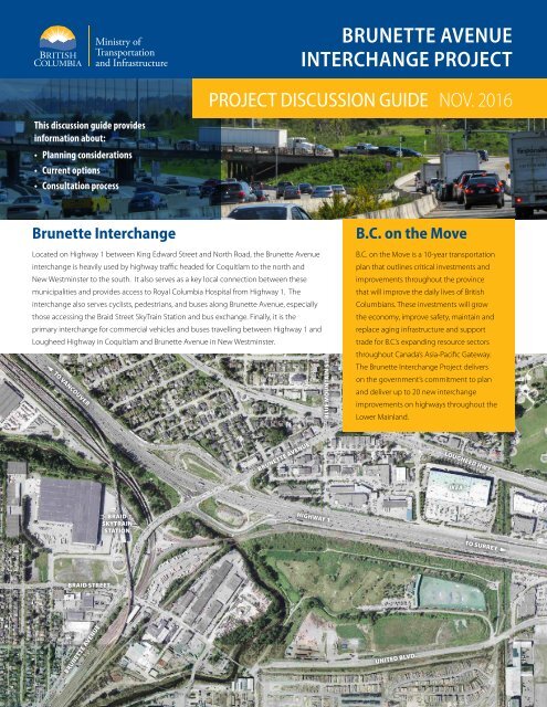
Brunette Interchange<br />
Located on Highway 1 between King Edward Street and North Road, the Brunette Avenue<br />
interchange is heavily used by highway traffic headed for Coquitlam to the north and<br />
New Westminster to the south. It also serves as a key local connection between these<br />
municipalities and provides access to Royal Columbia Hospital from Highway 1. The<br />
interchange also serves cyclists, pedestrians, and buses along Brunette Avenue, especially<br />
those accessing the Braid Street SkyTrain Station and bus exchange. Finally, it is the<br />
primary interchange for commercial vehicles and buses travelling between Highway 1 and<br />
Lougheed Highway in Coquitlam and Brunette Avenue in New Westminster.<br />
~ to Vancouver<br />
Blue <strong>Mountain</strong> St.<br />
B.C. on the Move<br />
B.C. on the Move is a 10-year transportation<br />
plan that outlines critical investments and<br />
improvements throughout the province<br />
that will improve the daily lives of British<br />
Columbians. These investments will grow<br />
the economy, improve safety, maintain and<br />
replace aging infrastructure and support<br />
trade for B.C.’s expanding resource sectors<br />
throughout Canada’s Asia-Pacific Gateway.<br />
The Brunette Interchange Project delivers<br />
on the government’s commitment to plan<br />
and deliver up to 20 new interchange<br />
improvements on highways throughout the<br />
Lower Mainland.<br />
Brunette Avenue<br />
Lougheed Hwy.<br />
IKEA<br />
Braid<br />
SKYTRAIN<br />
STATION<br />
Highway 1<br />
To surrey /<br />
Braid Street<br />
Brunette Avenue<br />
United blvd.
Brunette Avenue Interchange Project Project Discussion Guide: NOV. 2016<br />
The Need for<br />
Improvements<br />
Traffic Safety: Originally constructed<br />
in the1960s, the interchange ramps can<br />
be difficult to negotiate, particularly for<br />
large trucks. The Brunette Interchange<br />
is the most crash prone location within<br />
Coquitlam and accounts for 10% of all<br />
crashes in the City.<br />
Congestion: Due to the limited capacity<br />
of the ramps, traffic is frequently backed<br />
up during peak periods. Connections<br />
to the municipal network are very close<br />
to the interchange itself, causing large<br />
volumes of lane-changing over a short<br />
distance and can cause significant<br />
congestion.<br />
Regional Goods and People<br />
Movement: Congestion at the<br />
interchange is an impediment to the flow<br />
of goods and truck traffic throughout<br />
the region. In addition, there are many<br />
at-grade rail crossings that hamper the<br />
efficiency of the adjacent rail network,<br />
which is an important economic driver for<br />
the entire region.<br />
Project Benefits<br />
The Ministry of Transportation and<br />
Infrastructure is considering options to<br />
improve the Brunette Avenue Interchange.<br />
The new interchange will be designed to:<br />
Consultation Process<br />
We are here<br />
Previous<br />
studies<br />
Municipal<br />
ENGAGEMENT<br />
Stakeholder<br />
ENGAGEMENT<br />
Develop<br />
Conceptual Ideas<br />
Public Consultation<br />
on Options<br />
Public Consultation<br />
Summary Report (Early 2017)<br />
Further Technical<br />
Analysis (if required)<br />
Further Consultation<br />
(if required)<br />
Identify<br />
Preferred Option<br />
• Traffic analysis<br />
• Technical analysis<br />
• Environmental analysis<br />
Ongoing consultation and planning<br />
with City of Coquitlam staff and City of<br />
New Westminster staff.<br />
Ongoing consultation with TransLink,<br />
Royal Columbian Hospital and future<br />
developments.<br />
Project Goals<br />
The following goals were developed based on technical analysis of traffic patterns, stakeholder feedback and local, regional and<br />
provincial transportation needs.<br />
Relieve Congestion<br />
m Relieve congestion on Highway 1<br />
m Enable more efficient access to Highway 1 and local arterial roads<br />
m Improve reliability, congestion and reduce travel times<br />
Improve Traffic Safety<br />
m Reduce incidents by simplifying traffic movements and reducing<br />
lane changes<br />
m Enhance safety for all modes by modernizing interchange design<br />
m Reduce vehicle / rail conflicts<br />
Value<br />
m Manage project costs to deliver best value<br />
Royal Columbian Hospital<br />
m Improve regional access to Royal Columbian Hospital<br />
m Protect access for emergency vehicles, employees, patients and<br />
visitors.<br />
Cyclists and Pedestrians<br />
m Support cyclists and pedestrians crossing the highway<br />
m Improve access to Braid Street Skytrain station and between regional<br />
greenways<br />
Accommodate Transit Service<br />
m Accommodate current and proposed bus routes<br />
Support Community Planning<br />
m Accommodate existing community plans<br />
Connect Communities<br />
m Provide regional connectivity between adjacent communities,<br />
across the highway, for all modes of travel<br />
m Minimize impact to local traffic and roads.<br />
Regional Goods and People Movement<br />
m Improve truck access and goods movement between Highway 1<br />
and local arterial roads<br />
m Improve direct access through direct municipal connections<br />
m Improve rail efficiency by reducing vehicle / rail conflicts<br />
m Improve traffic safety for all modes<br />
m Reduce travel times<br />
m Facilitate the efficient movement of<br />
goods<br />
m Improve traffic flow at the interchange<br />
and along area arterial roads<br />
m Connect areas separated by the highway<br />
m Facilitate regional access to Royal<br />
Columbian Hospital<br />
m Improve pedestrian and cyclist access<br />
across Highway 1<br />
m Improve access to transit<br />
Currently the project is in the planning<br />
phase and the public consultation is<br />
aimed at soliciting information on the<br />
proposed options.<br />
2<br />
3
Brunette Avenue Interchange Project Project Discussion Guide: NOV. 2016<br />
Key Constraints<br />
Options to improve the Brunette Avenue Interchange are limited by a variety of physical constraints. These include: topography, existing<br />
and future developments, rail lines, SkyTrain guideway and stations, a variety of utilities, and sensitive environmental features such as the<br />
Brunette River and previous land fill sites.<br />
Evaluation Criteria<br />
Based on the project goals and consultation to date, the following key comparative evaluation<br />
criteria have been identified for the Brunette Interchange project to assess the options and<br />
identify a preferred option:<br />
Coquitlam<br />
BLUE MOUNTAIN ST<br />
Travel Time Savings<br />
Based on the savings of reduced travel times through the interchange options and adjacent municipal roadways<br />
Traffic Safety<br />
Bernatchey<br />
Includes design standards and ease of navigation<br />
Planning Level Cost Estimate<br />
Developed as part of a planning study with enough detail to compare options. These include: utility relocations and<br />
greyhound<br />
station<br />
property acquisition. Investments requested from federal, provincial and municipal governments<br />
WOOLRIDGE ST<br />
Property Impacts<br />
The number of commercial, residential, and industrial properties that are affected<br />
New Westminster<br />
Rousseau St.<br />
Royal Columbian Hospital Access<br />
Based on ease of navigation and travel time within the region for private and emergency vehicles<br />
Cyclist and Pedestrian<br />
Level of accommodation for the cyclist and pedestrian movements across Highway 1 between the Braid SkyTrain<br />
Station and Coquitlam<br />
Canfor Ave.<br />
Coquitlam<br />
Accommodate Transit Service<br />
Keary<br />
Street<br />
Allen<br />
Street<br />
Proposed MIXED USE development<br />
“Sapperton Green”<br />
Old Terra Nova Landfill Site<br />
Royal Columbian Hospital<br />
Redevelopment<br />
Pump station<br />
Level of accommodation of existing and proposed bus routes servicing the Braid Skytrain Station<br />
Environmental Impact<br />
Including potential disruption of natural land and waterways<br />
Support Community Planning<br />
Spruce St<br />
Key Traffic Intersection<br />
Railway right-of-way<br />
Skytrain Line<br />
River<br />
Based on the compatibility and consistency with existing community plans<br />
Regional Goods and People Movement<br />
Removal of at-grade rail crossings in New Westminster. More efficient regional truck movement<br />
OVERHEAD BC HYDRO TRANSMISSION LINE<br />
Cumberland St<br />
REGIONAL TRUNK SEWER<br />
REGIONAL WATER TRANSMISSION PIPE<br />
RIPARIaN AREA<br />
4<br />
5
Brunette Avenue Interchange Project Project Discussion Guide: NOV. 2016<br />
Local Planning<br />
Local transportation improvements and initiatives documented in the official community plans and transportation plans of the adjacent communities<br />
were considered in the development of the options for the new interchange. Both municipalities have been involved at the technical level. The<br />
Ministry of Transportation and Infrastructure understands that these plans are being updated and will actively accommodate revisions as is feasible.<br />
Key elements and initiatives relevant to the interchange study area have been summarized below.<br />
City of Coquitlam<br />
The City of Coquitlam has been one of the fastest growing municipalities<br />
in British Columbia over the last 20 years and is expected to add another<br />
100,000 people by 2041. The recent and anticipated rapid growth rate<br />
will place significant pressure on the transportation system in the years<br />
ahead.<br />
Any future improvements to the Brunette Interchange will need to<br />
consider the goals and principles of the Citywide Official Community<br />
Plan (OCP) in relation to the Maillardville Neighbourhood Plan (MNP)<br />
such as supporting commercial, residential and employment living land<br />
uses in the Maillardville Neighbourhood Centre. Key goals of the MNP<br />
also include maintaining the Service Commercial, Industrial, and Civic<br />
and Major Institutional land use designations for the Lougheed Brunette<br />
Area and fostering a revitalized commercial main street along Brunette<br />
Avenue that provides a variety of pedestrian friendly neighbourhoodserving<br />
commercial services.<br />
In addition, the City’s Strategic Transportation Plan (STP) presents a<br />
vision for each of the primary modes of travel. The Brunette Avenue<br />
Interchange Project is relevant to several goals of the STP including:<br />
m<br />
A Vital Economy. Move people and goods efficiently and safely.<br />
m<br />
Strategic Transportation Choices. Prioritize walking, cycling, transit,<br />
and other sustainable modes of transportation.<br />
m<br />
Meeting Changing Community Service and Infrastructure<br />
Needs. Manage the transportation system efficiently as the community<br />
evolves.<br />
Specifically, the STP identifies as a transportation priority a new<br />
pedestrian/cyclist crossing of Highway 1 to connect Maillardville with the<br />
Braid Street Skytrain Station.<br />
As the improvement options get more defined, the City of Coquitlam will<br />
be expecting an evaluation on how each option addresses Maillardville<br />
values and goals contained in the OCP and STP. As well, as part of this<br />
process the City of Coquitlam expects that the Province addresses the<br />
need for improved goods and transportation connectivity west of the<br />
United Boulevard.<br />
City of New Westminster<br />
The City of New Westminster is also planning to grow, and expects<br />
another 40,000 residents by the 2041. The City does not support any<br />
options that require added capacity onto New Westminster roads,<br />
including Brunette Avenue. The Master Transportation Plan and the<br />
Official Community Plan have the following objective:<br />
“Work towards the principle of no new added capacity in the Transportation System for<br />
vehicles passing through New Westminster between other municipalities. In order to minimize<br />
congestion, it is desirable to avoid attracting more regional traffic to New Westminster.”<br />
The city’s Master Transportation Plan provides long-term direction that<br />
will guide transportation policies, priorities and investments within<br />
each element of the transportation network over the next 25 years and<br />
includes Goal 6: Sustainable Transportation System: To manage the<br />
impacts of the transportation system.<br />
m<br />
Prioritize walking, cycling, transit, carpooling, and goods movement<br />
over the single occupant vehicle<br />
m<br />
Work with other agencies and neighbouring communities to provide<br />
multi-modal connections between New Westminster’s neighbourhoods<br />
and to neighbouring municipalities and regional destinations<br />
m<br />
Work with other agencies to encourage alternative modes of goods<br />
movement, including water and rail, and to develop alternative corridors<br />
outside of the city for the movement of goods not destined to the city<br />
m<br />
Manage the impacts of traffic moving through the city by limiting<br />
motor vehicle capacity while supporting local access and mobility<br />
m<br />
Support transportation demand management initiatives which<br />
promote shifts to sustainable transportation and a reduction in single<br />
occupancy vehicle trips<br />
Regional Planning and Rail Efficiency<br />
The Brunette Avenue Interchange provides critical connectivity between<br />
Highway 1 and other key regional routes. Maintaining and improving<br />
the efficiency of goods movement in the region is a key objective of<br />
the Ministry of Transportation and Infrastructure as well as TransLink.<br />
Currently, the interchange is an impediment to the flow of goods and<br />
truck traffic throughout the region. In addition to improving truck based<br />
goods movement, examining ways to improve rail efficiency in the region<br />
represents another key objective of these agencies. Closure of the atgrade<br />
crossings at Braid Street, Spruce Street, and Cumberland Street will:<br />
m<br />
Improve traffic safety<br />
m<br />
Reduce idling of vehicles at level crossings, energy use, and<br />
greenhouse gas emissions<br />
m<br />
Reduce or eliminate the necessity for train whistling<br />
m<br />
Enhance the efficiency and safety of rail operations<br />
m<br />
Accommodate the anticipated growth in trade-related traffic<br />
m<br />
Increase national trade competitiveness by increasing goods<br />
movement along the corridor<br />
m<br />
Support the Pacific Gateway Project<br />
TransLink<br />
TransLink is responsible for planning, financing and managing<br />
transportation modes and services in the Metro Vancouver region,<br />
including the Major Road Network (MRN), truck routes, and transit service.<br />
As the regional transportation authority, TransLink is working with the<br />
Ministry of Transportation and Infrastructure to ensure design options for<br />
the improved Brunette Avenue Interchange address regional transit and<br />
transportation needs.<br />
TransLink also owns and maintains several bridges in the region, including<br />
the Pattullo Bridge, Knight Street Bridge, Golden Ears Bridge, Westham<br />
Island Bridge, and Canada Line bicycle and pedestrian bridge.<br />
TransLink’s Regional Transportation Strategy (RTS) Strategic Framework,<br />
adopted in August 2013, sets out the vision, goals, principles, strategies<br />
and key initiatives to accommodate one million more people expected to<br />
live in the region by 2045, along with the resulting growth in demand on<br />
the transportation system. The RTS brings together strategies on investing<br />
in system expansion, managing demand, and coordinating land use in<br />
order to ensure that transportation decisions are affordable and that<br />
communities are livable with prosperous businesses, safe streets, clean air<br />
and thriving natural environments.<br />
The two main targets of the RTS are:<br />
1. Reduce average driving distances by 33%.<br />
2. Make half our trips by walking, cycling and transit.<br />
These targets are set to help the region reach the shared vision as<br />
one of the best places in the world to live because our transportation<br />
needs are met in a way that simultaneously improves the health of our<br />
communities, economy, and environment.<br />
6<br />
7
Brunette Avenue Interchange Project Project Discussion Guide: NOV. 2016<br />
Option A – Brunette Interchange with Separate Municipal Connections<br />
The main crossing of Highway 1 at the Brunette Avenue interchange is separated into two corridors: a two lane corridor for local traffic crossing Highway 1,<br />
and a four lane corridor for traffic entering or exiting Highway 1.<br />
highway exit/Entrance<br />
highway 1<br />
bridge/Overpass<br />
Railway<br />
Closed At-Grade<br />
Rail Crossing<br />
Municipal boundary<br />
Royal Columbian<br />
Hospital<br />
Traffic light<br />
the Braid Street<br />
Skytrain station<br />
Highway 1 to Vancouver<br />
1<br />
Bernatchey St.<br />
9<br />
6<br />
5<br />
6<br />
2<br />
3<br />
Bluemt.<br />
7<br />
4<br />
Tupper Ave.<br />
Brunette Ave.<br />
Lougheed Hwy.<br />
Ikea<br />
Woolridge St.<br />
Highway 1 to Surrey<br />
Key Features<br />
1 The local traffic corridor is based on the existing Brunette Avenue<br />
overpass structure that connects Brunette Avenue in Coquitlam<br />
with Braid Street in New Westminster, and primarily serves local New<br />
Westminster – Coquitlam traffic with no access to Highway 1.<br />
2 Inter-region traffic corridor connects Blue <strong>Mountain</strong> Street and<br />
Lougheed Highway in Coquitlam with Brunette Avenue in New<br />
Westminster, and handles most of the traffic interchanging with<br />
Highway 1.<br />
3 Highway 1 Eastbound traffic can directly access Blue <strong>Mountain</strong> Street<br />
/ Brunette Avenue southbound or Blue <strong>Mountain</strong> Street northbound.<br />
Traffic would not be able to access Brunette Avenue directly.<br />
4 Highway 1 Westbound traffic can directly access Brunette Avenue<br />
East, or Blue <strong>Mountain</strong> Street South.<br />
5 Blue <strong>Mountain</strong> Street Southbound traffic can directly access<br />
Highway 1 westbound, but cannot access Highway 1 eastbound.<br />
6 Brunette Avenue traffic can directly access Highway 1 westbound<br />
or eastbound.<br />
7 Lougheed Highway connects to Blue <strong>Mountain</strong> Street via a single<br />
at-grade intersection. This requires a grade separation between Blue<br />
<strong>Mountain</strong> Street and Brunette Avenue and between Brunette Avenue<br />
and Lougheed Highway. Lougheed Highway has access to Brunette<br />
Avenue via Bernatchey Street and Woolridge Street, and provides<br />
eastbound Highway 1 access for Coquitlam traffic.<br />
8 United Boulevard is extended to connect to Brunette Avenue.<br />
A local traffic connection continues from Brunette Avenue via<br />
Rousseau Street to Braid Street.<br />
9 Pedestrian and Cycling multi-use pathway is provided along the<br />
north side of Brunette Avenue and across Highway 1 connecting<br />
Coquitlam to the Braid SkyTrain Station.<br />
10 At-Grade Railroad Crossings are closed at Braid Street, Spruce<br />
Street, and Cumberland Street<br />
Note: All intersections located within the interchange along Brunette Avenue and Lougheed<br />
Highway will be signalized.<br />
Cumberland St.<br />
E Columbuia St.<br />
Keary St.<br />
Allen St.<br />
Brunette ave.<br />
Spruce St.<br />
Rousseau St.<br />
New<br />
Westminster<br />
Braid St.<br />
Capilano Way<br />
Edworthy Way<br />
8<br />
Canfor Ave.<br />
Braid St.<br />
3<br />
United Boulevard<br />
BRITISH<br />
COLUMBIA<br />
Ministry of Transportation<br />
5<br />
8 5<br />
6<br />
Coquitlam<br />
OPTION 3 C - SEGREGATED HIGHWAY CROSSING<br />
2<br />
7<br />
BRUNETTE AVENUE INTERCHANGE<br />
OPTION EVALUATION<br />
4<br />
EXHIBIT<br />
1<br />
Evaluation: Option A -<br />
Brunette Interchange with Separate Municipal Connections<br />
– Travel times moderately reduced in both morning and afternoon peak periods.<br />
– Smoother transitions on and off of Hwy 1 without traffic signals.<br />
– High amount of commercial properties impacted in Coquitlam and moderate amount of industrial properties impacted in New Westminster.<br />
– All routes to Royal Columbian Hospital have lower travel times.<br />
– Improved access across the Hwy 1 for pedestrians and cyclists with dedicated path.<br />
– Bus routes diverted to Woolridge Street due to lack of connection between Lougheed Hwy and Brunette Ave. Potentially shorter routes using<br />
United Blvd connection.<br />
– Environmental impacts are envisioned with two new bridges over the Brunette River.<br />
Planning Level<br />
Cost Estimate<br />
$530M<br />
Pedestrian and<br />
Cyclist access<br />
High<br />
Improvement<br />
o<br />
TRAVEL TIME SAVINGS<br />
Traffic<br />
(HOURS PER DAY)<br />
Safety<br />
High Improvement<br />
High<br />
2700 IMMEDIATE<br />
Improvement<br />
4000 Future (2045) BRITISH<br />
COLUMBIA<br />
Ministry of Transportation<br />
o<br />
Transit Services<br />
Impact<br />
Low<br />
impact<br />
o<br />
o<br />
Environment<br />
Impact<br />
Sensitive Lands<br />
o Low impact<br />
o Brunette River<br />
MEDIUM impact<br />
Property<br />
Impacts<br />
High<br />
IMPACT<br />
BRUNETTE AVENUE INTERCHANGE<br />
OPTION EVALUATION<br />
o<br />
OPTION 3 C - SEGREGATED HIGHWAY CROSSING<br />
SUPPORT Community<br />
PLANNING<br />
o Coquitlam<br />
MEDIUM impact<br />
o New West<br />
MEDIUM impact<br />
Royal columbian<br />
hospital Access<br />
High<br />
Improvement<br />
EXHIBIT<br />
1<br />
o<br />
Regional Goods<br />
and people<br />
Movement<br />
High Improvement<br />
o<br />
8<br />
9
Brunette Avenue Interchange Project Project Discussion Guide: NOV. 2016<br />
Option B – Blue <strong>Mountain</strong> Interchange with United Boulevard Connection<br />
This option is based on extending Blue <strong>Mountain</strong> Street over Highway 1 to United Boulevard. Intersection on the overpass would become<br />
the main access points to Highway 1, however some access to and from Brunette Avenue would be maintained.<br />
highway exit/Entrance<br />
highway 1<br />
bridge/Overpass<br />
Railway<br />
Closed At-Grade<br />
Rail Crossing<br />
Municipal boundary<br />
Royal Columbian<br />
Hospital<br />
Traffic light<br />
the Braid Street<br />
Skytrain station<br />
Allen St.<br />
Highway 1 to Vancouver<br />
Rousseau St.<br />
New<br />
Westminster<br />
Braid St.<br />
8<br />
Canfor Ave.<br />
3<br />
1<br />
6<br />
Braid St.<br />
6<br />
9<br />
Bernatchey St.<br />
4<br />
5<br />
2<br />
Bluemt.<br />
7<br />
2<br />
5<br />
4<br />
Tupper Ave<br />
6<br />
Brunette Ave.<br />
United Boulevard<br />
Ikea<br />
Woolridge St.<br />
Lougheed Hwy.<br />
Highway 1 to Surrey<br />
Coquitlam<br />
Key Features<br />
1<br />
The local traffic corridor is based on the existing Brunette Avenue<br />
corridor, which connects Brunette Avenue in Coquitlam with Brunette<br />
Avenue in New Westminster.<br />
2 Inter-region traffic corridor connects Blue <strong>Mountain</strong> Street<br />
in Coquitlam with United Boulevard and handles the majority of the<br />
Coquitlam originating or destined traffic interchanging with Highway 1.<br />
3 Highway 1 Eastbound traffic can directly access Brunette Avenue<br />
and travel to the north (left turn) or south (right turn), or continue<br />
through the intersection along the connecting ramp to Blue <strong>Mountain</strong><br />
Street to travel north (left turn) or south (right turn).<br />
4 Highway 1 Westbound traffic can directly access Blue <strong>Mountain</strong><br />
Street to travel north or south, or continue through the intersection<br />
along the connecting road to Brunette Avenue northbound. Access to<br />
Brunette Avenue southbound would be provided from a second offramp<br />
from Highway 1.<br />
5 Blue <strong>Mountain</strong> Street traffic can directly access Highway 1<br />
eastbound or Highway 1 westbound from the connecting ramp via a<br />
right turn at the north road terminal intersection and through the north<br />
Evaluation: Option B -<br />
ramp intersection and continuing through the intersection at Brunette<br />
Avenue to the highway.<br />
6 Brunette Avenue traffic can directly access Highway 1 westbound or<br />
eastbound.<br />
7 Lougheed Highway connects to Blue <strong>Mountain</strong> Street via a single<br />
at-grade intersection. This requires a grade separation between Blue<br />
<strong>Mountain</strong> Street and Brunette Avenue and between Brunette Avenue and<br />
Lougheed Highway. Lougheed Highway has access to Brunette Avenue<br />
via Bernatchey Street and Woolridge Street.<br />
8 United Boulevard is extended to Brunette Avenue, with only a<br />
westbound United Boulevard to southbound Brunette Avenue ramp and<br />
a northbound Brunette Avenue to eastbound United Boulevard ramp.<br />
9 Pedestrian and Cycling multi-use pathway is provided along<br />
the north side of Brunette Avenue and across Highway 1 connecting<br />
Coquitlam to the Braid SkyTrain Station.<br />
10 At-Grade Railroad Crossings are closed at Braid Street, Spruce<br />
Street, and Cumberland Street.<br />
Note: All intersections located within the interchange along Brunette Avenue and Lougheed Highway<br />
will be signalized.<br />
Blue <strong>Mountain</strong> Interchange with United Boulevard Connection<br />
– Travel times slightly reduced in both morning and afternoon peak periods.<br />
– Intersections to ramps on and off of Hwy 1 have traffic signals.<br />
– Moderate amount of commercial properties impacted in Coquitlam and moderate amount of industrial properties impacted in New Westminster.<br />
– All routes to Royal Columbian Hospital have lower travel times.<br />
– Access across Hwy 1 for pedestrians and cyclists with path crossing 2 highway ramps.<br />
– Bus routes diverted to Woolridge Street due to lack of connection between Lougheed Hwy and Brunette Ave.<br />
– Environmental impacts are envisioned with a new bridge over the Brunette River and some impact to the previous landfill.<br />
Cumberland St.<br />
E Columbia St.<br />
Keary St.<br />
Brunette Ave.<br />
Spruce St.<br />
Capilano Way<br />
Edworthy Way<br />
3<br />
6<br />
9<br />
6<br />
4<br />
2<br />
4<br />
Planning Level<br />
Cost Estimate<br />
$510M<br />
TRAVEL TIME SAVINGS<br />
(HOURS PER DAY)<br />
MEDIUM Improvement<br />
1500 IMMEDIATE<br />
2200 Future (2045)<br />
o<br />
Traffic<br />
Safety<br />
MEDIUM<br />
Improvement<br />
o<br />
Property<br />
Impacts<br />
MEDIUM<br />
IMPACT<br />
o<br />
Royal columbian<br />
hospital Access<br />
High<br />
Improvement<br />
o<br />
3<br />
5<br />
Pedestrian and<br />
Cyclist access<br />
MEDIUM<br />
Improvement<br />
o<br />
Transit Services<br />
Impact<br />
MEDIUM<br />
impact<br />
o<br />
Environment<br />
Impact<br />
Sensitive Lands<br />
o o MEDIUM-HIGH<br />
o Brunette River<br />
LOW impact<br />
SUPPORT Community<br />
PLANNING<br />
o Coquitlam<br />
MEDIUM impact<br />
o New West<br />
MEDIUM impact<br />
Regional Goods<br />
and people<br />
Movement<br />
High Improvement<br />
o<br />
10<br />
11
Brunette Avenue Interchange Project Project Discussion Guide: NOV. 2016<br />
Option C – Blue <strong>Mountain</strong> Interchange with Braid Industrial Area Connector<br />
Key Features<br />
Cumberland St.<br />
This option is similar to “B” and is centred on the “Blue <strong>Mountain</strong> Interchange” overpass. The direct connection between United Boulevard and<br />
Brunette Avenue is replaced by a two lane connection from Blue <strong>Mountain</strong> Street to Columbia Street via the Braid Industrial Area Connector (BIAC),<br />
and a tunnel under the rail lines and Brunette River.<br />
highway exit/Entrance<br />
highway 1<br />
bridge/Overpass<br />
Railway<br />
Closed At-Grade<br />
Rail Crossing<br />
Municipal boundary<br />
Royal Columbian<br />
Hospital<br />
Traffic light<br />
the Braid Street<br />
Skytrain station<br />
E Columbuia St.<br />
New<br />
Westminster<br />
Keary St.<br />
Allen St.<br />
Spruce St.<br />
Highway 1 to Vancouver<br />
Rousseau St.<br />
Brunette Ave.<br />
Braid St.<br />
Capilano Way<br />
Edworthy Way<br />
Canfor Ave.<br />
3<br />
Braid St.<br />
Braid Industrial area connector<br />
6<br />
3<br />
8<br />
1<br />
9<br />
6<br />
6<br />
9<br />
6<br />
Bernatchey St.<br />
5<br />
2<br />
4<br />
3<br />
Bluemt.<br />
7<br />
5<br />
Tupper Ave<br />
4<br />
Brunette Ave.<br />
United Boulevard<br />
4<br />
2<br />
Lougheed Hwy.<br />
Ikea<br />
Woolridge St.<br />
Highway 1 to Surrey<br />
Coquitlam<br />
4<br />
1<br />
The local traffic corridor is based on the existing Brunette Avenue<br />
corridor, which connects Brunette Avenue in Coquitlam with Brunette<br />
Avenue in New Westminster.<br />
2 Inter-region traffic corridor connects Blue <strong>Mountain</strong> Street in<br />
Coquitlam with United Boulevard and handles the majority of the<br />
Coquitlam originating or destined traffic interchanging with Highway 1.<br />
3 Highway 1 Eastbound traffic can directly access Brunette Avenue and<br />
travel to the north (left turn) or south (right turn), or continue through the<br />
intersection along the connecting ramp to Blue <strong>Mountain</strong> Street to travel<br />
north (left turn) or south (right turn).<br />
4 Highway 1 Westbound traffic can directly access Blue <strong>Mountain</strong> Street<br />
to travel north or south, or continue through the intersection along the<br />
connecting road to Brunette Avenue northbound. Access to Brunette Avenue<br />
southbound would be provided from a second off-ramp from Highway 1.<br />
5 Blue <strong>Mountain</strong> Street traffic can directly access Highway 1 eastbound<br />
or Highway 1 westbound from the connecting ramp via a right turn at the<br />
north road terminal intersection and through the north ramp intersection<br />
and continuing through the intersection at Brunette Avenue to the<br />
highway.<br />
Evaluation: Option C -<br />
6<br />
Brunette Avenue traffic can directly access Highway 1 westbound or<br />
eastbound.<br />
7 Lougheed Highway connects to Blue <strong>Mountain</strong> Street via a single<br />
at-grade intersection. This requires a grade separation between Blue<br />
<strong>Mountain</strong> Street and Brunette Avenue and between Brunette Avenue and<br />
Lougheed Highway. Lougheed Highway has access to Brunette Avenue<br />
via Bernatchey Street and Woolridge Street.<br />
8 Braid Industrial Area Connector consists of a four lane at-grade<br />
roadway to the south end of Edworthy Way, where the new roadway<br />
transitions to a two lane tunnel under the railway tracks and Brunette<br />
River. The connection at Columbia Street also includes a southbound<br />
Brunette Avenue to southbound Columbia Street ramp and a northbound<br />
Columbia Street to northbound Brunette Avenue ramp.<br />
9 Pedestrian and Cycling multi-use pathway is provided along<br />
the north side of Brunette Avenue and across Highway 1 connecting<br />
Coquitlam to the Braid SkyTrain Station.<br />
10 At-Grade Railroad Crossings are closed at Braid Street, Spruce<br />
Street, and Cumberland Street.<br />
Note: All intersections located within the interchange along Brunette Avenue and Lougheed Highway will be signalized.<br />
Blue <strong>Mountain</strong> Interchange with Braid Industrial Area Connector<br />
– Travel times very slightly reduced in both morning and afternoon peak periods.<br />
– Intersections to ramps on and off of Hwy 1 have traffic signals.<br />
– Moderate amount of commercial properties impacted in Coquitlam and high amount of industrial properties impacted in New Westminster.<br />
– Most routes to Royal Columbian Hospital have lower travel times. United Blvd has longer travel time.<br />
– Access across the Hwy 1 for pedestrians and cyclists with path crossing 2 highway ramps.<br />
– Bus routes diverted to Woolridge Street due to lack of connection between Lougheed Hwy and Brunette Ave.<br />
– High environmental impact on Brunette River with the construction of a cut and cover tunnel, and some impacts to previous landfill.<br />
Planning Level<br />
Cost Estimate<br />
$620M<br />
TRAVEL TIME SAVINGS<br />
(HOURS PER DAY)<br />
LOW Improvement<br />
1400 IMMEDIATE<br />
1600 Future (2045)<br />
o<br />
Traffic<br />
Safety<br />
MEDIUM<br />
Improvement<br />
o<br />
Property<br />
Impacts<br />
HIGH<br />
IMPACT<br />
o<br />
Royal columbian<br />
hospital Access<br />
MEDIUM<br />
Improvement<br />
o<br />
3<br />
5<br />
Pedestrian and<br />
Cyclist access<br />
MEDIUM<br />
Improvement<br />
o<br />
Transit Services<br />
Impact<br />
MEDIUM<br />
impact<br />
o<br />
Environment<br />
Impact<br />
Sensitive Lands<br />
o o MEDIUM-HIGHT<br />
o Brunette River<br />
HIGH impact<br />
SUPPORT Community<br />
PLANNING<br />
o Coquitlam<br />
MEDIUM impact<br />
o New West<br />
LOW impact<br />
Regional Goods<br />
and people<br />
Movement<br />
High Improvement<br />
o<br />
12<br />
13
Brunette Avenue Interchange Project Project Discussion Guide: NOV. 2016<br />
Evaluation Comparison<br />
Brunette Avenue Interchange: Present Day<br />
14<br />
CRITERIA OPTION A OPTION B OPTION C<br />
Planning Level<br />
Cost Estimate<br />
Weekday Travel<br />
Total Time Savings<br />
(Hours per day)<br />
Traffic Safety<br />
Property<br />
Impacts<br />
Royal Columbian<br />
Hospital Access<br />
Pedestrian and<br />
Cyclist Access<br />
Transit Service<br />
Impacts<br />
Potential<br />
Environmental<br />
Impacts<br />
Support<br />
Community<br />
Planning<br />
Regional Goods<br />
and People<br />
Movement<br />
$530M $510M<br />
$620M*<br />
o High Improvement o Medium Improvement o Low Improvement<br />
2700 Immediate<br />
4000 Future (2045)<br />
o High Improvement<br />
• Designed to modern standards<br />
• No ramp terminal intersections<br />
with conflicting movements<br />
o High Impact<br />
• High amount of commercial properties<br />
impacted in Coquitlam and moderate<br />
amount of industrial properties<br />
impacted in New Westminster<br />
o High Improvement<br />
• All routes to Royal Columbian<br />
Hospital have lower travel time<br />
o High Improvement<br />
• Separate path with no (0) ramp<br />
intersection conflicts<br />
o Low Impact<br />
• Bus routes diverted to Woolridge<br />
Street due to lack of connection<br />
between Lougheed Highway and<br />
Brunette Avenue<br />
• Provides potential for shorter routes<br />
using United Blvd Connection<br />
o Low Impact<br />
on Sensitive Lands<br />
• Does not impact the closed landfill<br />
o Medium Impact<br />
on Brunette River<br />
• Two Bridges over Brunette River<br />
o Medium Impact (Coquitlam)<br />
• Lougheed Highway Bridge over<br />
Brunette Avenue not consistent<br />
with City’s plans<br />
o Medium Impact<br />
(New Westminster)<br />
• United Boulevard Connection<br />
does not align with OCP or Master<br />
Transportation Plan<br />
o High Improvement<br />
• More efficient regional truck<br />
movement and at-grade rail<br />
crossings removed in<br />
New Westminster<br />
1500 Immediate<br />
2200 Future (2045)<br />
o Medium Improvement<br />
• Designed to modern standards<br />
• Four (4) ramp terminal<br />
intersections with conflicting<br />
movements<br />
o Medium Impact<br />
• Moderate amount of commercial<br />
properties impacted in Coquitlam<br />
and moderate amount of industrial<br />
properties impacted in New Westminster<br />
o High Improvement<br />
• All routes to Royal Columbian<br />
Hospital have lower travel time<br />
o Medium Improvement<br />
• Separate path with two (2) ramp<br />
intersection conflicts<br />
o Medium Impact<br />
• Bus routes diverted to Woolridge<br />
Street due to lack of connection<br />
between Lougheed Highway and<br />
Brunette Avenue<br />
• Provides no potential for shorter<br />
routes<br />
o o Medium to High Impacton<br />
Sensitive Lands<br />
• Does impact the closed landfill<br />
o Low Impact on Brunette River<br />
• Low impact on Brunette River<br />
• One bridge over Brunette River<br />
o Medium Impact (Coquitlam)<br />
• Blue <strong>Mountain</strong> connection<br />
generally compatible with City’s<br />
plans<br />
o Medium Impact<br />
(New Westminster)<br />
• United Boulevard Connection<br />
does not align with OCP or Master<br />
Transportation Plan<br />
o High Improvement<br />
• More efficient regional truck<br />
movement and at-grade rail<br />
crossings removed in<br />
New Westminster<br />
1400 Immediate<br />
1600 Future (2045)<br />
o Medium Improvement<br />
• Designed to modern standards<br />
• Four (4) ramp terminal intersections<br />
with conflicting movements<br />
o High Impact<br />
• Moderate amount of commercial<br />
properties impacted in Coquitlam and<br />
high amount of industrial properties<br />
impacted in New Westminster<br />
o Medium Improvement<br />
• Most routes to Royal Columbian<br />
Hospital have lower travel time<br />
• United Boulevard route has higher<br />
travel time<br />
o Medium Improvement<br />
• Separate path with two (2) ramp<br />
intersection conflicts<br />
o Medium Impact<br />
• Bus routes diverted to Woolridge<br />
Street due to lack of connection<br />
between Lougheed Highway and<br />
Brunette Avenue<br />
• Provides no potential for shorter<br />
routes<br />
o o Medium to High Impact<br />
on Sensitive Lands<br />
• Does impact the closed landfill<br />
o High Impact on Brunette River<br />
• High impact on Brunette River<br />
• Cut & cover tunnel under Brunette<br />
River<br />
o Medium Impact (Coquitlam)<br />
• United Boulevard Connection<br />
tie-in with BIAC does not align with<br />
City’s plans<br />
o Low Impact<br />
(New Westminster)<br />
• BIAC tunnel compatible with<br />
City’s truck tunnel concept<br />
o High Improvement<br />
• More efficient regional truck<br />
movement and at-grade rail<br />
crossings removed in<br />
New Westminster<br />
*This cost estimate is less certain due to the risks of tunnel construction.<br />
~ to Vancouver<br />
Feedback<br />
Brunette Avenue<br />
IKEA<br />
Highway 1<br />
1. Considering this list, which THREE goals are the most important to you for the Brunette Avenue ìnterchange:<br />
(Please check only three)<br />
N Relieve Congestion<br />
N Improve Traffic Safety<br />
N Value (managing project costs)<br />
N Access to Royal Columbian Hospital<br />
N Accommodate Cyclists and Pedestrians<br />
N Accomodate Transit Service<br />
N Support Community Planning<br />
N Connect Communities<br />
N Regional Goods and People Movement<br />
2. Considering this list, which THREE goals are the least important to you for the Brunette Avenue ìnterchange:<br />
(Please check only three)<br />
N Support Community Planning<br />
N Relieve Congestion<br />
N Access to Royal Columbian Hospital<br />
N Connect Communities<br />
N Improve Traffic Safety<br />
N Accommodate Cyclists and Pedestrians<br />
N Regional Goods and People Movement<br />
N Value (managing project costs) N Accomodate Transit Service<br />
3. If you have additional comments on the project goals, please provide them here:<br />
15
Brunette Avenue Interchange Project Project Discussion Guide: NOV. 2016<br />
4. Please indicate how important each of the following they are to you: 7. How would you rate Option A in terms of meeting your transportation needs?. (see pages 8 and 9 for more information)<br />
Extremely<br />
important<br />
Very<br />
important<br />
Travel Time Savings N N N N N<br />
Traffic Safety N N N N N<br />
Construction Costs N N N N N<br />
Neutral<br />
Not very<br />
important<br />
Not at all<br />
important<br />
Very<br />
good<br />
8. Why do you say that?<br />
(Please be specific.)<br />
Good Fair Poor Very<br />
poor<br />
N N N N N<br />
Property Impacts N N N N N<br />
Royal Columbian<br />
Hospital Access N N N N N<br />
Cyclists and Pedestrian N N N N N<br />
Accommodate Transit Service N N N N N<br />
Environmental Impact N N N N N<br />
Support Community<br />
Planning N N N N N<br />
9. If you have additional comments on the evaluation of Option A, please provide them here:<br />
Regional Goods and<br />
People Movement N N N N N<br />
5. Are there any evaluation criteria that you feel are missing and should be added?<br />
10. How would you rate Option B in terms of meeting your transportation needs? (see pages 10 and 11 for more information)<br />
N N N N N<br />
6. What impact, if any, do you feel this project may have on your community?<br />
11. Why do you say that?<br />
(Please be specific.)<br />
16<br />
17
Brunette Avenue Interchange Project Project Discussion Guide: NOV. 2016<br />
12. If you have additional comments on the evaluation of Option B, please provide them here:<br />
About you<br />
16. To help us understand where the people who are interested<br />
in this project to live, please provide your postal code. (Optional)<br />
17. In what City do you work/attend school? (Or, indicate your most common destination.)<br />
13. How would you rate Option C in terms of meeting your transportation needs? (see pages 12 and 13 for more information)<br />
Very<br />
good<br />
Good Fair Poor Very<br />
poor<br />
N N N N N<br />
18. On average, how often do you use the Brunette Interchange?<br />
(Please select one option.)<br />
N Everyday<br />
N A few times a week<br />
N At least once a week<br />
N Once a year or less<br />
14. Why do you say that?<br />
(Please be specific.)<br />
19.<br />
N At least once a month<br />
What is your most common mode of travel.<br />
(Please select one option)<br />
N Never<br />
N Car<br />
N Walk<br />
N Bus / transit<br />
N Other (Please specify) ______________________<br />
N Bike<br />
15. If you have any additional comments on the evaluation of Option C, please provide them here.<br />
Additional Information<br />
20. If you have additional comments on the Brunette Interchange Project, please provide them here:<br />
18<br />
19
Thank you for your input<br />
Personal information will only be used to provide you with updates on the Brunette Interchange Project and will not be shared.<br />
Please return your completed feedback form by December 23, 2016 through one of the following ways:<br />
Online survey: www.engage.gov.bc.ca/brunetteinterchange/<br />
Email: brunetteinterchange@gov.bc.ca<br />
Mail: Brunette Interchange Feedback<br />
c/o Ministry of Transportation<br />
310 – 1500 Woolridge St.<br />
Coquitlam, BC V3K0B8