

Royalties for RegionS Carbon Project - showcase
R4R%20Carbon%20Magazine%20Aug16
R4R%20Carbon%20Magazine%20Aug16

You also want an ePaper? Increase the reach of your titles
YUMPU automatically turns print PDFs into web optimized ePapers that Google loves.
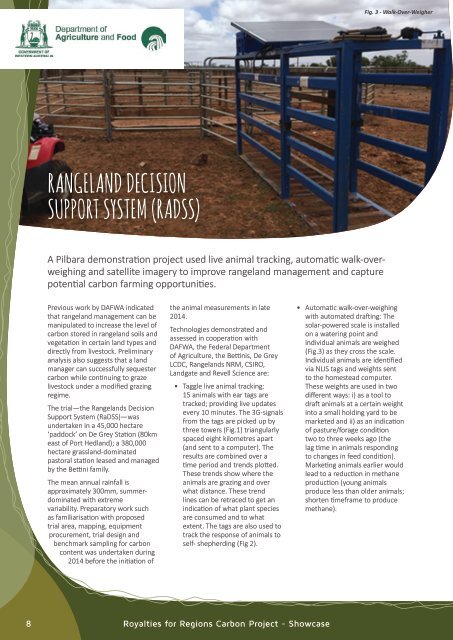
Fig. 3 - Walk-Over-Weigher<br />
Rangeland Decision<br />
Support System (RaDSS)<br />
A Pilbara demonstration project used live animal tracking, automatic walk-overweighing<br />
and satellite imagery to improve rangeland management and capture<br />
potential carbon farming opportunities.<br />
Previous work by DAFWA indicated<br />
that rangeland management can be<br />
manipulated to increase the level of<br />
carbon stored in rangeland soils and<br />
vegetation in certain land types and<br />
directly from livestock. Preliminary<br />
analysis also suggests that a land<br />
manager can successfully sequester<br />
carbon while continuing to graze<br />
livestock under a modified grazing<br />
regime.<br />
The trial—the Rangelands Decision<br />
Support System (RaDSS)—was<br />
undertaken in a 45,000 hectare<br />
‘paddock’ on De Grey Station (80km<br />
east of Port Hedland); a 380,000<br />
hectare grassland-dominated<br />
pastoral station leased and managed<br />
by the Bettini family.<br />
The mean annual rainfall is<br />
approximately 300mm, summerdominated<br />
with extreme<br />
variability. Preparatory work such<br />
as familiarisation with proposed<br />
trial area, mapping, equipment<br />
procurement, trial design and<br />
benchmark sampling <strong>for</strong> carbon<br />
content was undertaken during<br />
2014 be<strong>for</strong>e the initiation of<br />
the animal measurements in late<br />
2014.<br />
Technologies demonstrated and<br />
assessed in cooperation with<br />
DAFWA, the Federal Department<br />
of Agriculture, the Bettinis, De Grey<br />
LCDC, Rangelands NRM, CSIRO,<br />
Landgate and Revell Science are:<br />
• Taggle live animal tracking:<br />
15 animals with ear tags are<br />
tracked; providing live updates<br />
every 10 minutes. The 3G-signals<br />
from the tags are picked up by<br />
three towers (Fig.1) triangularly<br />
spaced eight kilometres apart<br />
(and sent to a computer). The<br />
results are combined over a<br />
time period and trends plotted.<br />
These trends show where the<br />
animals are grazing and over<br />
what distance. These trend<br />
lines can be retraced to get an<br />
indication of what plant species<br />
are consumed and to what<br />
extent. The tags are also used to<br />
track the response of animals to<br />
self- shepherding (Fig 2).<br />
• Automatic walk-over-weighing<br />
with automated drafting: The<br />
solar-powered scale is installed<br />
on a watering point and<br />
individual animals are weighed<br />
(Fig.3) as they cross the scale.<br />
Individual animals are identified<br />
via NLIS tags and weights sent<br />
to the homestead computer.<br />
These weights are used in two<br />
different ways: i) as a tool to<br />
draft animals at a certain weight<br />
into a small holding yard to be<br />
marketed and ii) as an indication<br />
of pasture/<strong>for</strong>age condition<br />
two to three weeks ago (the<br />
lag time in animals responding<br />
to changes in feed condition).<br />
Marketing animals earlier would<br />
lead to a reduction in methane<br />
production (young animals<br />
produce less than older animals;<br />
shorten timeframe to produce<br />
methane).<br />
8<br />
<strong>Royalties</strong> <strong>for</strong> Regions <strong>Carbon</strong> <strong>Project</strong> - Showcase