AR

You also want an ePaper? Increase the reach of your titles
YUMPU automatically turns print PDFs into web optimized ePapers that Google loves.
INSPIRE<br />
<strong>AR</strong>CHAEOLOGY FROM SPACE<br />
National Geographic explorers are using data from satellites hundreds of miles<br />
above the Earth along with other remote-sensing technology to improve detection<br />
of ancient hominid remains in Africa.<br />
Explorers-in-Residence Meave and Louise Leakey and National Geographic<br />
Fellow Sarah Parcak employed airborne hyperspectral lidar and multispectral satellite<br />
imagery to survey Kenya’s Turkana Basin. The area is fossil rich but difficult to work in<br />
because of challenges posed by both terrain and geological conditions. This project<br />
leveraged Parcak’s pioneering use of similar archaeological tools in Egypt.<br />
Lidar—which stands for light detection and ranging—uses a pulsed laser to generate<br />
precise, three-dimensional information about the shape and surface characteristics<br />
of the Earth. The team is overlaying the project map generated by lidar with soil<br />
data from satellites to create high-resolution 3-D landscape imaging that will be put<br />
into service in the field on iPads, creating virtual ground-survey guides.<br />
In addition to collecting project data, Parcak and the Leakeys will develop a field<br />
school in Kenya for remote sensing, GIS, and advanced surveying techniques. The<br />
school will take advantage of free online resources such as Google Earth and Esri’s<br />
GIS tools to build capacity among Kenyan anthropologists.<br />
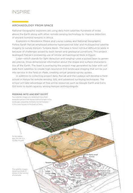
PEERING INTO ANCIENT EGYPT<br />
Two satellite images are combined into a highresolution<br />
picture that shows subtle changes in the<br />
landscape caused by shallowly buried features—<br />
in this case, houses in the town of Tanis.<br />
To the naked<br />
eye, the site is a<br />
muddy mound.<br />
PROTECTING THE OCEAN’S LAST WILD PLACES<br />
“We’re working to contribute to the largest ocean legacy in human history,” says<br />
Enric Sala, National Geographic Explorer-in-Residence and executive director of<br />
National Geographic’s Pristine Seas project. The exploration, research, and media<br />
initiative aims to permanently protect pristine places in the ocean, covering several<br />
million square kilometers of wild marine habitats by the year 2020. Pristine Seas<br />
expeditions produce key data that help make the case for conservation of the world’s<br />
most remote and unspoiled marine sites. Policy work and media outreach inspire<br />
communities and governments to protect these wild places from the harmful effects<br />
of overfishing, pollution, and habitat destruction.<br />
Sala’s team has already contributed to the protection of 400,000 square kilometers<br />
of ocean, an area the size of California. The team conducted nine expeditions to remote<br />
locations between 2009 and 2013. Three of the sites now have status as marine protected<br />
areas—the Pacific Remote Islands National Monument (U.S.), Seamounts Marine<br />
Managed Area (Costa Rica), and Motu Motiro Hiva Marine Park (Chile)—and we have a<br />
verbal commitment for a system of marine parks covering 20 percent of Gabon’s coastal<br />
waters. Five sites are in progress, among them three marine environments explored in<br />
2013: the Desventuradas Islands off the coast of Chile, Franz Josef Land in the Russian<br />
Arctic, and New Caledonia in the South Pacific. The team has an ambitious expedition<br />
schedule in the years ahead to help protect the last wild places in the ocean.<br />
To learn more, visit nationalgeographic.org/pristineseas.<br />
Early small<br />
homes<br />
Temple<br />
The satellite images<br />
reveal hundreds of<br />
homes in the vicinity<br />
of a temple.<br />
Large<br />
homes<br />
Large<br />
homes<br />
Medium and<br />
small homes<br />
Above left: A large lobster makes its home in the Desventuradas Islands. Right top: Explorer-in-<br />
Residence Enric Sala takes a sample of marine life. Right bottom: Fish cluster on a healthy reef<br />
in the Line Islands of Kiribati.<br />
2013 ANNUAL REPORT 11