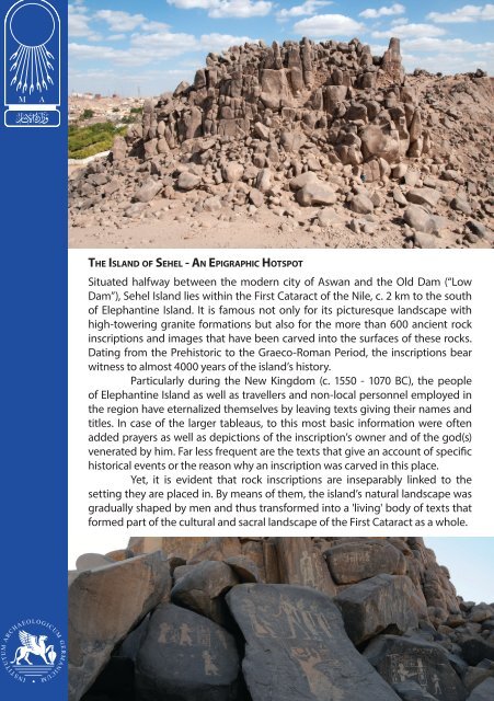
The Island Sehel - An Epigraphic Hotspot

Create successful ePaper yourself
Turn your PDF publications into a flip-book with our unique Google optimized e-Paper software.
<strong>The</strong> <strong>Island</strong> of <strong>Sehel</strong> - <strong>An</strong> <strong>Epigraphic</strong> <strong>Hotspot</strong><br />
Situated halfway between the modern city of Aswan and the Old Dam (“Low<br />
Dam”), <strong>Sehel</strong> <strong>Island</strong> lies within the First Cataract of the Nile, c. 2 km to the south<br />
of Elephantine <strong>Island</strong>. It is famous not only for its picturesque landscape with<br />
high-towering granite formations but also for the more than 600 ancient rock<br />
inscriptions and images that have been carved into the surfaces of these rocks.<br />
Dating from the Prehistoric to the Graeco-Roman Period, the inscriptions bear<br />
witness to almost 4000 years of the island’s history.<br />
Particularly during the New Kingdom (c. 1550 - 1070 BC), the people<br />
of Elephantine <strong>Island</strong> as well as travellers and non-local personnel employed in<br />
the region have eternalized themselves by leaving texts giving their names and<br />
titles. In case of the larger tableaus, to this most basic information were often<br />
added prayers as well as depictions of the inscription’s owner and of the god(s)<br />
venerated by him. Far less frequent are the texts that give an account of specific<br />
historical events or the reason why an inscription was carved in this place.<br />
Yet, it is evident that rock inscriptions are inseparably linked to the<br />
setting they are placed in. By means of them, the island’s natural landscape was<br />
gradually shaped by men and thus transformed into a 'living' body of texts that<br />
formed part of the cultural and sacral landscape of the First Cataract as a whole.
<strong>The</strong> Rocks of <strong>Sehel</strong> <strong>Island</strong> - Telling Witnesses to the History of the First Cataract<br />
Located on top of an intrusive granite-granodiorite pluton, the area of Aswan is<br />
characterized by large outcrops of igneous rocks such as pink granite, which are exposed<br />
along the Nile and form its First Cataract. Especially during the pharaonic era, the surfaces<br />
of these rocks were widely used for carving inscriptions and images. Thousands of these<br />
inscriptions can still be found throughout the city area and today represent an important<br />
and unique part of Aswan’s cultural heritage.<br />
Besides the specific geographical conditions, epigraphic usage of the landscape<br />
was also stimulated by the continuous strategic role as well as the economic, political and<br />
social importance of the First Cataract. For since the beginning of its colonization more<br />
than 5000 years ago, the region has always been a border area with mixed population,<br />
an important military base, a place of extensive granite and diorite quarries and a rich<br />
centre of trade between Egypt and Sub-Saharan Africa. That is why there has always been<br />
a continual coming and going of state officials, military personnel and (since the New<br />
Kingdom) priests, who belonged mainly to the administration of the great <strong>The</strong>ban temples<br />
and were sent to supervise the clergy of the provincial sanctuaries.<br />
Especially these non-local people often took the opportunity to leave a visual<br />
mark at prominent sites they had worked at, or they had visited, in order to participate in<br />
cult activities. For this reason it is fundamental to firstly study the titles mentioned in the<br />
texts and to determine the social composition of the persons represented. Secondly, one<br />
has to link this set of people and their memorial inscriptions to the topographical setting.<br />
By this means, in many cases the ancient landscape and its functional aspects can be<br />
reconstructed, and the question why a certain place was chosen can be answered.<br />
<strong>The</strong> by far largest group of rock inscriptions can be found in the southern part of<br />
<strong>Sehel</strong> <strong>Island</strong>. A close look at the profession and social status of the people eternalized here as<br />
well as the content of the texts reveals that the island had once been an important religious<br />
site within the First Cataract region. Most of the inscriptions are connected to the cult of<br />
the goddess <strong>An</strong>uket, the so-called lady of <strong>Sehel</strong>. <strong>The</strong> large tableaus, in particular, frequently<br />
show the inscription’s owner while venerating <strong>An</strong>uket, and she is also the one most often<br />
invoked in the prayers. From other sources it is known, that a sanctuary of <strong>An</strong>uket was<br />
situated on <strong>Sehel</strong> <strong>Island</strong>, and that her annual feast centered on a river procession, in which<br />
a cult image of the goddess travelled from Elephantine to <strong>Sehel</strong> and back. It was believed<br />
that by placing a rock inscription near the ritual place or the processional path one could<br />
participate eternally in this major local cult and its public festival(s).<br />
Scholars on <strong>Sehel</strong> <strong>Island</strong> - 200 Years of Studying the <strong>Island</strong>’s History<br />
<strong>The</strong> island of <strong>Sehel</strong> and its vast amount of rock inscriptions aroused scholarly interest as<br />
early as the beginning of the 19th century. Among the first European travellers visiting the<br />
First Cataract region was the British adventurer William John Bankes (1786-1855), whose<br />
folio of notes and drawings give an account of local monuments and other archaeological<br />
remnants, that are today largely destroyed or damaged. <strong>The</strong> first scientific studies in the<br />
area of Aswan were conducted by the Royal Prussian Expedition to Egypt and Sudan<br />
(1842-1845), led by Carl Richard Lepsius. <strong>The</strong> expedition’s team, which included scholars,<br />
geographers, architects and surveyors (e.g. Georg Gustav Erbkam; see an entry of his diary<br />
cited below), as well as artists, also copied some of the most prominent monumental<br />
inscriptions. This was followed by a series of epigraphic ventures carried out by Auguste<br />
Mariette (1867), Heinrich Brugsch (1884), and Jacques De Morgan (1893), who, with the help<br />
of his colleagues, recorded and published 230 of the island’s texts.<br />
In the 20th century, Labib Habachi (1906-1994) devoted a great deal of his time<br />
and research to the rock inscriptions of the Aswan area and, thereby, gained many in-depth<br />
insights into the meaning and significance of the epigraphic heritage of the First Cataract<br />
region. However, while revising the copies made by De Morgan and others, it became<br />
evident that the hitherto existing catalogue needed to be replaced by a new one that also<br />
incorporated new discoveries. Eventually, a large volume, covering more than 550 texts<br />
displayed on the rocks of <strong>Sehel</strong>, was released in 2007 by <strong>An</strong>nie Gasse and Vincent Rondot.<br />
Even after almost 200 years, research on the island’s history and the textual<br />
tradition of its inscriptions is still not completed and will require further investigation.<br />
Sunday 29th Sept(ember) 1844<br />
“My birthday and departure from Philae. [...]<br />
As for the continuation of our journey, navigating through the rapids and past the shallows called for<br />
our utmost attention [...]; We were on top of the boat’s roof watching the spectacle with keen interest,<br />
and gazed at the changing landscapes, while passing along the desert on the west bank and a great<br />
variety of towering rock islands. Later, we disembarked on the beautiful island of <strong>Sehel</strong>e, opposite<br />
another island called Senarti. On the former, we found the remains of ancient monuments and,<br />
covered in potsherds, large outcrops of rock featuring a multitude of stelae, which were 'exploited' by<br />
(Carl Richard) Lepsius and Max (Weidenbach); [...]”<br />
Georg Gustav Erbkam, Tagebuch meiner aegyptischen Reise (Diary of my Egyptian Journey)
How to explore the Rocks of <strong>Sehel</strong><br />
A Guide to the Pharaonic Rock Inscriptions and Archaeological Remains on the <strong>Island</strong><br />
01 Large Tableau belonging to the viceroy of Kush, Huy. During the New Kingdom,<br />
Kush was an Egyptian province in Lower Nubia that was governed by a viceroy, who<br />
was appointed by the Egyptian king. Huy, who lived in the 19th Dynasty and served<br />
under king Ramesses II (1279-1213 BCE), is shown in the lower part of the relief, his<br />
hands uplifted in adoration. In the upper part, his master, Ramesses II, offers wine<br />
to the local gods Khnum, Satet and <strong>An</strong>uket, who form the Triad of Elephantine. <strong>The</strong><br />
text underneath his elbow reads: “Giving wine to his father (i.e. Khnum)”.<br />
02 Most inscriptions’ owners have themselves depicted with insignia of office<br />
and rank. In this case, Payamen, with shaven head and short apron, carries an armshaped<br />
censer, in which he is burning incense grains in front of the cartouche of<br />
Amenophis II (18th Dynasty, 1428-1397 BCE). His handling of the ritual instrument<br />
as well as his dress both illustrate the titles of Payamen mentioned in the accompanying<br />
text. He was an 'offerer of Amun', 'scribe of the god’s offering' and 'bearer of<br />
the arm-shaped censer of this perfect god', all of which are priestly titles.<br />
01<br />
02<br />
05<br />
03<br />
06<br />
04<br />
03 <strong>An</strong>uket was the most revered goddess and the main recipient of the cult on<br />
<strong>Sehel</strong>. Hence, she is often depicted and appealed to in the local rock inscriptions.<br />
But only rarely is the adoration of a statue of <strong>An</strong>uket shown - e.g. in the tableau of<br />
the 'chief portrait sculptor in the Temple of Ra', Amenemipet (New Kingdom, 19th<br />
Dynasty). Here, the sculptor, who himself was responsible for the carving of temple<br />
statues, is adoring a statue of the island’s goddess, which is placed on a pedestal<br />
and holding a papyrus scepter (wadj-sign) as well as a symbol of life (ankh-sign).<br />
04 Unlike Amenemipet (03), who was probably from <strong>The</strong>bes and just inspecting<br />
the quarries of Aswan, Khnumemwesekhet was mayor of Elephantine and, thus, belonged<br />
to the administrative elite of the region. He and his wife Hener, a chant-euse<br />
of Khnum, the lord of Elephantine, are shown worshipping a seated statue of<br />
<strong>An</strong>uket. Furthermore, the inscription attests to the ancient practice of damnatio<br />
memoriae, i.e. the erasure of the name and the symbolic damaging of the face and<br />
hands of a person who has fallen from grace and should not be remembered.<br />
05 Throughout antiquity, Aswan was famous for its extensive red granite quarries,<br />
where many of Egypt’s great monuments such as obelisks were cut. In this context,<br />
a great number of officials who supervised works in the quarries commemorated<br />
themselves in rock inscriptions. One of them, Amenhotep, not only held the title<br />
of 'director of works in the great house of granite' during the reign of Hatshepsut<br />
(c. 1479-1458 BCE), but also was appointed high priest of <strong>An</strong>uket. That is why, in his<br />
tableau, he is wearing a leopard’s skin, which is part of the high priest’s sacred robe.<br />
06 Besides the Triad of Elephantine (Khnum, Satet and <strong>An</strong>uket), in<br />
Bakenkhons’ inscription also Amun, 'king of the gods' and main god<br />
of the New Kingdom, as well as Ramesses VI (20th Dynasty, c. 1142-<br />
1134 BCE) are venerated. Bakenkhons is known from the so-called<br />
Turin Indictment Papyrus (“Elephantine scandal”). <strong>The</strong>re it is reported<br />
that other priests had plotted to prevent him from being promoted<br />
to the position of high priest of Khnum by manipulating the oracle’s<br />
decision. But they failed and, eventually, their scheme was exposed.<br />
07 In front of Ramesses II (19th Dynasty, 1279-1213 BCE), one of his officials, Khnumemhab,<br />
is depicted on a smaller scale in the act of adoration. While his right hand is<br />
lifted, his left holds either a scribe’s palette or a papyrus roll. <strong>The</strong> attribute refers to<br />
his profession as a 'chief archivist in the two royal treasuries', 'chief scribe in the temple<br />
of Amun', and 'overseer of sealed goods in the southern foreign lands'. Particularly<br />
the latter title links Khnumemhab to the extraction and delivery of gold from<br />
Nubia’s eastern desert, which were, at this time, under the control of Amun’s temple.<br />
09 <strong>The</strong> epigraphic usage of <strong>Sehel</strong>’s landscape started already in the Old Kingdom.<br />
<strong>The</strong> Inscriptions of that period are concentrated especially near the southern bay<br />
and, for the most part, only give the name and title of the inscription’s owner. Lacking<br />
further information, it is difficult to determine why people commemorated<br />
themselves in this place. However, it can be assumed that <strong>Sehel</strong> played an important<br />
role in the control of the border region at the First Cataract. Furthermore, it is<br />
likely that already early in the island’s history it was viewed as a religious site.<br />
10 <strong>The</strong> prominent, high-lying rock features three inscriptions from different times.<br />
In the upper part, the viceroy of Kush Sethy is shown kneeling and adoring the cartouches<br />
of king Siptah (19th Dynasty, c. 1194-1186 BCE). Beneath it, the depiction<br />
and name of another viceroy, Usersatet (temp. Amenophis II, 1428-1397 BCE), who<br />
somehow must have fallen into disgrace, are partly erased. At his feet, three small<br />
male figures of varying colours probably represent the deities Petempamentes, Petensetis<br />
and Petensenis, who were venerated on <strong>Sehel</strong> <strong>Island</strong> in the Ptolemaic era.<br />
12 In ancient times, the First Cataract was considered the gateway to Nubia and<br />
in order to travel southwards, both trade expeditions as well as military troops had<br />
to pass through it. <strong>The</strong> importance of this route is illustrated by a group of texts<br />
located along the eastern hillside of Bibi Tagug. Among them, a tableau dating from<br />
the reign of Senwosret III (c. 1872-1853 BCE) commemorates the king’s campaign<br />
against Nubia and his command to clear out a navigation channel near <strong>Sehel</strong>, that<br />
was hence named “Beautiful are the ways of Khakaure (Senwosret III) eternally”.
© German Archaeological Institute,<br />
Department Cairo, 2015<br />
Text/Layout: Linda Borrmann<br />
Print: IFAO, Cairo<br />
German Archaeological Institute,<br />
Department Cairo<br />
31, Sh. Abu el-Feda<br />
11211 Cairo - Zamalek, Egypt<br />
Phone: +20-2-2735-1460<br />
Fax: +20-2-2737-0770<br />
sekretariat.kairo@dainst.de<br />
www.dainst.org<br />
Have a Safe <strong>Sehel</strong> Experience!<br />
Please stick to the footpaths and mind your step,<br />
as the rocky paths may be slippery.<br />
Don‘t climb the steep slopes and cliffs,<br />
as they are very unstable.<br />
Please do not drop litter and help us to keep the<br />
archaeological site tidy.
08<br />
<strong>The</strong> Shrine of <strong>An</strong>uket<br />
<strong>The</strong> Lady of <strong>Sehel</strong> and her Shrine at Hussein Tagug<br />
<strong>The</strong> main goddess venerated on <strong>Sehel</strong> <strong>Island</strong> was <strong>An</strong>uket, who was also commonly called<br />
the lady of <strong>Sehel</strong>. <strong>The</strong> site of her shrine was most probably located on a narrow terrace<br />
embedded within the eastern hillside of Hussein Tagug, where a broad niche had been<br />
cut into the face of the hill’s granite. Today no visible traces of the shrine’s architecture,<br />
however humble it may have been, are left, but there is strong evidence for the existence of<br />
a prominent ancient sanctuary in this area. First and foremost, the overwhelming number<br />
of dedicatory rock inscriptions assembled opposite and around the niche (see inscription<br />
of Kaemkemet cited below) attests to its religious importance (at least from the late Middle<br />
Kingdom onwards). In addition, two relief slabs made of sandstone were found at <strong>Sehel</strong>,<br />
of which one was later sold to the Brooklyn Museum in New York (see picture below). It<br />
displays two symmetrical offering scenes, in which king Sobekhotep (13th Dynasty, c.<br />
1744-1741 BCE) presents a vase to both female deities of the Triad of Elephantine, and it<br />
once formed part either of a small shrine or an altar dedicated to <strong>An</strong>uket.<br />
<strong>The</strong> situation is thus similar to other sanctuaries in the First Cataract region. As in<br />
the case of the temple of Satet at Elephantine, it is likely that also on <strong>Sehel</strong> <strong>Island</strong> the local<br />
goddess was believed to be immanent in a conspicuous feature of the natural landscape.<br />
Apparently, specific rock formations such as niches, exceptionally shaped boulders or large<br />
potholes were often considered as sacred and, as a result, used as ritual places.<br />
<strong>The</strong> relief of Sobekhotep III<br />
(13th Dynasty, c. 1744-1741<br />
BCE) shows the king offering<br />
a vessel each to the goddess<br />
Satet (left) and to the goddess<br />
<strong>An</strong>uket (right). It probably<br />
formed part of a shrine that<br />
housed the cult image of<br />
<strong>An</strong>uket on <strong>Sehel</strong> <strong>Island</strong>.<br />
(courtesy of the<br />
Brooklyn Museum,<br />
New York)<br />
Rock Inscription of Kaemkemet (see picture above)<br />
“<strong>An</strong> offering that the king gives (to) Khnum, Satet, <strong>An</strong>uket, and the gods, the lords of Elephantine.<br />
<strong>An</strong> offering that the king gives (to) <strong>An</strong>uket, the lady of <strong>Sehel</strong>,<br />
Osiris, foremost of the west, and <strong>An</strong>ubis, who is upon his hill,<br />
so that they may give<br />
a thousand of beer and bread, a thousand of flesh and fowl, a thousand of offerings,<br />
a thousand of incense and oil, as well as a thousand of every good and pure thing<br />
to the Ka (i.e. the soul of a deceased person) of the high priest of Satet, <strong>An</strong>uket, and the gods,<br />
the lords of Ta-seti (i.e. region to the south of Egypt), Ka(em)kemet.”<br />
Column 1-5 (Praying for Offerings)<br />
New Kingdom, 20th Dynasty (c. 1186-1070)<br />
“O living ones upon the earth,<br />
every priest, every god’s-father (i.e. a priest), every lector priest, every scribe,<br />
and everyone who knows his spell who may pass by this stela:<br />
the gods of your town shall favor you, you shall be loved (by) the king of your time,<br />
and shall bequeath your office to your children after old age,<br />
if you will say:<br />
'<strong>An</strong> offering that the king gives (to) Khnum, Satet, and <strong>An</strong>uket of all good and pure things to the Ka of<br />
the high priest of Khnum, Satet, and <strong>An</strong>uket, Kaemkemet!' “<br />
Column 6-12 (Appeal to the Living)
11<br />
<strong>The</strong> Famine Stela<br />
<strong>The</strong> Famine Stela - <strong>An</strong> Extraordinary Text and its Historical Background<br />
One of the most discussed and most intriguing inscriptions carved on the rocks of <strong>Sehel</strong><br />
<strong>Island</strong> is the so-called Famine Stela. <strong>The</strong> monumental stela, measuring 180 cm x 171 cm,<br />
is featured on the face of a large free-standing granite boulder on the summit of Bibi<br />
Tagug and facing in a south-eastern direction. When it was found in 1890 by the American<br />
archaeologist Charles Wilbour, the text instantly caused some puzzlement over its dating<br />
and authorship. For though language and phrasing clearly indicate that it is a work of the<br />
Ptolemaic era (304-30 BCE), the events described are stated to have taken place in the Old<br />
Kingdom, during the reign of king Djoser (c. 2665-2645 BCE).<br />
In 32 vertical lines (columns) the inscription recounts that one year the river Nile<br />
failed to rise high enough to flood the lands and that, hereupon, Egypt was afflicted by a<br />
severe seven-year-long famine. Distraught over the hardship his people are facing, Djoser,<br />
second king of the 3rd Dynasty, writes to the 'governor of the domains of the south', Mesir,<br />
who is probably stationed at Elephantine <strong>Island</strong>. <strong>The</strong> king tells him that he has consulted<br />
a wise lector-priest in order to obtain knowledge on the source of the Nile and how to<br />
influence its actions. From him he has learned that the god Khnum of Elephantine, like a<br />
divine doorkeeper, controls the coming of the Nile flood as it enters Egypt on its southern<br />
border. Later, Khnum appears to Djoser in a dream promising him to restore the inundation<br />
and, thus, to end the famine. Relieved and deeply grateful, the king now issues a decree.<br />
<strong>The</strong>rein, he donates the region of the Dodekaschoinos (“twelve mile land”, i.e. northern<br />
part of Lower Nubia, from the First Cataract to Takompso) as well as a 10 percent share<br />
each of the revenue derived from it and from Nubian trade to the temple of Khnum on<br />
Elephantine <strong>Island</strong>. Moreover, it is ordered that the temple shall be restored and its new<br />
resources shall be used as offerings to Khnum. Accordingly, right above the text of the<br />
stela, king Djoser is depicted, while burning incense for (i.e. offering to) Khnum-Ra, Satet,<br />
and <strong>An</strong>uket, which form the Triad of Elephantine.<br />
To this day, it is still uncertain who originally composed the text of the Famine Stela,<br />
and when it was cut into the stone. Although a few scholars believe it to originate from a<br />
genuine decree of the 3rd Dynasty, the majority of Egyptologists regard the inscription’s<br />
early date as fiction. Hence, it was argued that the clergy of the temple of Khnum had<br />
been responsible for setting up the stela, because, in the Ptolemaic era, the temples of the<br />
local deities such as Khnum were eventually overshadowed by the Isis temple of Philae that<br />
was greatly enhanced at that time. Possibly the priests of Khnum – rivalling those of Isis –<br />
wanted to strengthen their position and claims with the aid of a 'pious forgery'.<br />
<strong>The</strong> Famine Stela, Column 1-4 (<strong>The</strong> King’s Lament)<br />
“I was in mourning on my throne,<br />
Those of the palace were in grief,<br />
My heart was in great affliction,<br />
Because Hapy [i.e. the deified Nile]<br />
had failed to come in time<br />
In a period of seven years. [...]<br />
Courtiers were needy, temples were shut,<br />
Shrines covered in dust,<br />
Everyone was in distress.”<br />
Column 6-9 (Source of the Nile)<br />
“<strong>The</strong>re is a town in the midst of the deep,<br />
Surrounded by Hapy, Yebu by name; [...]<br />
Khnum is the god [who rules] there,<br />
[He is enthroned above the deep],<br />
His sandals resting on the flood;<br />
He holds the door bolt in his hand,<br />
Opens the gate as he wishes.<br />
He is eternal there as Shu [i.e. god of wind and air],<br />
Bounty-giver, Lord-of-fields, so his name is called.”<br />
Columns 18-22 (Khnum’s Revelation)<br />
“I am Khnum, your maker!<br />
My arms are around you,<br />
To steady your body, to safeguard your limbs.<br />
[...] <strong>The</strong> shrine I dwell in has two lips,<br />
When I open up the well,<br />
I know Hapy hugs the field,<br />
A hug that fills each nose with life,<br />
For when hugged the field is reborn! [...]<br />
Hearts will be happier than ever before!”<br />
Columns 22-23 (<strong>The</strong> King’s Donation)<br />
“I awoke with speeding heart.<br />
Freed of fatigue I made this decree<br />
On behalf of my father Khnum.<br />
A royal offering to Khnum,<br />
Lord of the cataract region and chief of Nubia [...]”<br />
(For full translation, see M. Lichtheim,<br />
<strong>An</strong>cient Egyptian Literature, 3:94-103.)
Unveiling the Secrets of <strong>Sehel</strong> - Ongoing <strong>Epigraphic</strong> Research<br />
For almost 30 years, the German Archaeological Institute, in close co-operation with the<br />
Egyptian Ministry of <strong>An</strong>tiquities, has been working on the epigraphic heritage of the Aswan<br />
region. Since 2014, the team has also been conducting field work on <strong>Sehel</strong>. Its aims are to<br />
check and revise already published copies of texts, to survey and protect the area, as well<br />
as to detect and to document so far unknown rock inscriptions and images. Additionally,<br />
all available information about the local landscape and the ancient environment is being<br />
gathered. Thus, the scholars try to answer crucial questions regarding the different<br />
functional aspects of the island and the chronology of its usage during Pharaonic times.<br />
Amongst others, until now more than 60 dynastic rock images, mostly standing<br />
male figures lacking an inscription, were newly discovered. <strong>The</strong>se figures can be<br />
considered as self-representations of a semi-literate or illiterate personnel employed on<br />
<strong>Sehel</strong> <strong>Island</strong> from the Old Kingdom onwards and seem to be connected rather to the<br />
island’s function as an important check point within the First Cataract than to the local<br />
cult of <strong>An</strong>uket. While controlling and monitoring the border area south of Aswan, these<br />
people seem to have depicted themselves and their professional routine in the immediate<br />
vicinity of their workplace. It can be expected that further research on those depictions<br />
may shed light on various aspects such as the economic function and the evolution of<br />
the epigraphic usage of the island of <strong>Sehel</strong>, which are not yet entirely understood.<br />
How to Get to <strong>Sehel</strong> <strong>Island</strong><br />
A 20 minute motor boat or felucca trip from Aswan Harbour<br />
upstream the Nile, will get you to <strong>Sehel</strong> <strong>Island</strong>. Also, it is possible to<br />
take the local public ferry, a rowing boat, which is signed from the<br />
road south of the Aswan Stadium. At the landing place, a path leads<br />
up from the river bank to the entrance of the archaeological site<br />
with its two large hills of Hussein Tagug and Bibi Tagug, which are<br />
now enclosed by a metal fence.