Askern History

You also want an ePaper? Increase the reach of your titles
YUMPU automatically turns print PDFs into web optimized ePapers that Google loves.
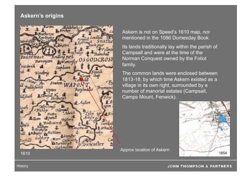
<strong>Askern</strong>’s origins<br />
<strong>Askern</strong> is not on Speed’s 1610 map, nor<br />
mentioned in the 1086 Domesday Book.<br />
Its lands traditionally lay within the parish of<br />
Campsall and were at the time of the<br />
Norman Conquest owned by the Foliot<br />
family.<br />
The common lands were enclosed between<br />
1813-18, by which time <strong>Askern</strong> existed as a<br />
village in its own right, surrounded by a<br />
number of manorial estates (Campsall,<br />
Camps Mount, Fenwick).<br />
1610<br />
Approx location of <strong>Askern</strong><br />
1854<br />
<strong>History</strong>
<strong>Askern</strong>’s heritage: under the ground<br />
At the end of the last Ice Age (12,000 years ago) the ice retreated, leaving an outcrop of<br />
Magnesium Limestone (<strong>Askern</strong> Hill) which overlooked a large inland sea called Lake Humber.<br />
(Origin of name: <strong>Askern</strong> (also sp. Askeron) from Saxon ‘sceron’ = cliff on dry land)<br />
Wetlands area<br />
<strong>Askern</strong> Lake and the surrounding wetland area has been a major feature of the district for<br />
centuries. A 14th century document mentions flooding along the north-south route (referred to at<br />
that time as ‘the King’s Highway’) due to <strong>Askern</strong> residents not looking after the pool properly.<br />
ASKERN<br />
Flooding in <strong>Askern</strong> 1932<br />
Digital elevation map showing<br />
area covered by Lake Humber<br />
1891 map showing<br />
proximity of road to lake<br />
Flooding in Sutton Common, 2000<br />
<strong>History</strong>
Archaeology at Sutton Common<br />
The nature of the local terrain led to the creation of an early Iron Age fort/enclosure at Sutton<br />
Common which used the surrounding marsh land as part of its defence. Excavations have<br />
discovered few remains of habitation so it may have been a symbolic or pagan religious<br />
enclosure (like Stonehenge).<br />
The most recent excavation work was<br />
carried out between 1997-2003 by the<br />
University of Exeter (Dept of<br />
Archaeology) and Hull (Wetlands<br />
Archaeology & Environment Research<br />
Centre) funded by English Heritage,<br />
Carstairs Countryside Trust & others<br />
2002 view of <strong>Askern</strong> & Sutton Common, showing the excavation<br />
trenches and the smaller enclosure under arable cultivation<br />
<strong>History</strong>
Sutton Common<br />
Artist’s impression<br />
from results of<br />
excavations<br />
showing what the<br />
Iron Age site might<br />
have looked like, if<br />
occupied. No<br />
evidence of<br />
inhabitation, only<br />
skulls from<br />
cemetery - marking<br />
entrance<br />
Diagram of Iron Age earthworks at<br />
Sutton Common<br />
1997 photo<br />
showing excavated<br />
corner post of the<br />
'portal’ at the<br />
entrance, rotted<br />
inside out due to<br />
drainage of site in<br />
the 1980s<br />
<strong>History</strong>
Connections: Roman Road<br />
<strong>Askern</strong> lies close to alternative Roman land<br />
route from Lincoln to York (Ermine Street<br />
crossed river Humber)<br />
Doncaster (Danum) was an important<br />
staging post - identified in 5th century<br />
Roman document; also garrison town - to<br />
control Brigantes tribe.<br />
Little evidence of Roman habitation in<br />
<strong>Askern</strong> area (probably too wet). Lands used<br />
for seasonal grazing & hunting.<br />
Roman coins have been found in the<br />
grounds of Camps Mount - possibly hidden<br />
by a Roman soldier - who never returned to<br />
claim them!<br />
ASKERN<br />
Camps Mount<br />
estate<br />
Maps showing<br />
alternative route from<br />
Lincoln to York in<br />
Roman days<br />
<strong>History</strong>
Leisure & recreation - Barnsdale<br />
Forest<br />
<strong>Askern</strong> lies near the former Barnsdale<br />
Forest - used in medieval days as a<br />
popular hunting ground by the nobility -<br />
also haunt of the outlaw Robin Hood in<br />
early ballads.<br />
There have been many attempts to<br />
identify the ‘real’ Robin Hood, also the<br />
knight in ‘A Lytell Geste of Robyn Hode’<br />
who was captured and later gave Robin<br />
Hood & his friends refuge in his castle.<br />
One possible candidate for the role of<br />
‘the gentlyll knyght, Syr Richard at the<br />
Lee’ is Richard Foliot (died 1299) who<br />
had lands in the <strong>Askern</strong> area (Norton &<br />
Fenwick) as well as Nottinghamshire.<br />
<strong>History</strong>
Campsall Hall, 1908, home of<br />
Bacon-Frank family<br />
Neighbouring<br />
manorial estates<br />
Camps Mount (formerly<br />
Brayton Hall), home of<br />
the Yarborough family<br />
Charabanc outing for the staff<br />
at Camps Mount, c 1910<br />
<strong>History</strong>
Connections: Turnpike Road & Railway<br />
<strong>Askern</strong> originated as a small farming community. Despite the 14th century reference to<br />
‘the king’s highway’ at <strong>Askern</strong> (maybe a track used by royalty when hunting in Barnsdale<br />
Forest), the village was not on a major route until the construction of a turnpike road in<br />
1834 from Doncaster to Tadcaster Cross. The railway arrived in the 1840s.<br />
1840s map showing location of <strong>Askern</strong> and surrounding settlements (Campsall, Norton, Fenwick)<br />
<strong>History</strong>
Spa Town surrounded by countryside<br />
The mix of limestone, sandstone, silts and clay<br />
gave the water of <strong>Askern</strong>’s springs their<br />
medicinal quality. Used locally by farmers to cure<br />
animals, it was mentioned in 1734 in ‘The<br />
Mineral Waters of Yorkshire’ by Dr Short.<br />
In 1786 Humphrey Osbaldeston (born Brookes)<br />
was Lord of the Manor at <strong>Askern</strong>. He decided to<br />
exploit several sulphur springs near the lake and<br />
erected a bathhouse at the water’s edge. This<br />
was replaced in 1815 by the larger Manor Baths<br />
- first cold, later heated.<br />
Manor Baths<br />
Mr Brewerton, a respected surgeon, wrote<br />
another treatise in 1818 and <strong>Askern</strong> gradually<br />
became known as an elegant spa town,<br />
surrounded by beautiful countryside, with plenty<br />
of recreational amenities for visitors.<br />
<strong>History</strong>
The Spa Town: By mid 19th century other bathing establishments had opened: Terrace<br />
Baths (1823), Charity Baths (1825), South Parade (1827) Madder Close Well (1828)<br />
Terrace Baths<br />
Manor Baths<br />
Charity Baths<br />
South Parade Baths<br />
<strong>History</strong>
1891<br />
<strong>Askern</strong> Hydropathic Hotel<br />
Built in 1826 by Dr Oxley, physician to<br />
the Charity Baths; wings used as<br />
lodging houses, Dr Oxley lived in central<br />
section. Later used as a College; in<br />
1894 became palatial Hydro<br />
Accommodation<br />
for visitors<br />
Cottages were turned<br />
into lodging houses<br />
and the first hotel was<br />
built in 1808. This<br />
later became a girls’<br />
school, finally the staff<br />
quarters for <strong>Askern</strong>’s<br />
Hydro<br />
1904<br />
Extent of Hydro<br />
grounds, c 1910<br />
<strong>History</strong>
The Swan Inn, rebuilt in 1817 and situated on <strong>Askern</strong>’s<br />
market place, was a major landmark of the town for nearly<br />
200 years until its recent demolition<br />
1891<br />
The Victorian Bridge: loss of another landmark<br />
<strong>History</strong>
Leisure & recreation: <strong>Askern</strong> Lake<br />
<strong>History</strong>
Leisure & recreation: health, hunting and entertainment<br />
The Badworth Hunt outside the Swan Hotel<br />
The Picture House (built c 1919), next to St Peter’s<br />
Church (built as a chapel by subscription in 1824,<br />
separate parish created 1852)<br />
The Hydro orchestra played daily concerts; there<br />
was also a band stand on an island in <strong>Askern</strong> Lake<br />
Inside the Hydro<br />
<strong>History</strong>
Connections: the Railway<br />
<strong>Askern</strong>’s reputation as a spa town was boosted by the opening of a station in June<br />
1847 - on Lancashire & Yorkshire Railway’s branch line to Knottingly - which linked<br />
with the Doncaster branch. <strong>Askern</strong> became a destination in its own right as well as a<br />
stopping point on the route to the north of England. (Closed Sept 1948)<br />
<strong>History</strong>
<strong>Askern</strong>’s growth: development along Moss Road<br />
1904<br />
1932<br />
<strong>History</strong>
Moss Road: mostly residential, with shops, hotel and boarding houses<br />
<strong>History</strong>
End of the Spa Town<br />
In 1908 a boring at Thorne<br />
proved the Barnsley seam of<br />
coal existed in an undivided<br />
bed between Doncaster and<br />
Goole.<br />
In March 1910 the <strong>Askern</strong> Spa<br />
Coal & Iron Company was<br />
formed (an agreement between<br />
Bestwood Coal & Iron Co,<br />
Nottingham & Blaina Colliery,<br />
Monmouthshire) to work the<br />
coal under the Campsall &<br />
Campsmount estates and<br />
adjoining lands.<br />
Over £250,000 was generated<br />
from private sources in support<br />
of the colliery - it was seen by<br />
some as a means of improving<br />
the local economy & amenities<br />
- by others as a blight on the<br />
surrounding countryside.<br />
1891 1932<br />
<strong>Askern</strong> Lake was drained when the pit was sunk as<br />
the springs were diverted. Spa attendance declined<br />
with the onset of World War I and by the end of the<br />
1920s <strong>Askern</strong> was known as a Colliery town.<br />
<strong>History</strong>
<strong>Askern</strong> Colliery<br />
The first sod was cut on 22<br />
February 1911, two shafts were<br />
sunk in May (21 ft in diameter).<br />
The Barnsley coal bed was<br />
reached at 568 yards in 9<br />
months. Output: up to 4,000<br />
tons per day. The railway was<br />
extended to serve the pit with a<br />
new bridge constructed over<br />
Campsall Road.<br />
<strong>History</strong>
<strong>Askern</strong> Colliery<br />
<strong>History</strong>
<strong>Askern</strong> Colliery<br />
<strong>History</strong>
Instoneville: a Model Village<br />
In 1920 Instoneville was built by <strong>Askern</strong> Garden City<br />
Association Ltd to house mine workers and their families.<br />
The design was inspired by the Garden City movement - with<br />
improved homes - gardens, inside water and baths; plus<br />
amenities: shops and recreation facilities. A hill was flattened<br />
on the Sutton side of <strong>Askern</strong> to create the estate. Sir Samuel<br />
Instone was the Chairman of <strong>Askern</strong> Coal & Iron Company.<br />
Location of Instoneville<br />
1925<br />
1932<br />
Sir Samuel Instone<br />
(1878-1937)<br />
<strong>History</strong>
Instoneville<br />
Paddling Pool built<br />
during the 1930s in<br />
<strong>Askern</strong>’s Welfare Park<br />
<strong>History</strong>
<strong>Askern</strong> High Street<br />
Stubbs Brothers shop<br />
There were shops along the<br />
Doncaster Road, adjacent to <strong>Askern</strong><br />
Lake, until the 1970s/80s when the<br />
road was widened: included a fish<br />
shop, a sweet shop and Stubbs the<br />
Grocers.<br />
1932 map showing location of<br />
High Street shops<br />
White Hart Hotel<br />
Houses backing on to<br />
<strong>Askern</strong> Lake from the<br />
High Street<br />
<strong>History</strong>
<strong>Askern</strong>’s Community Spirit<br />
<strong>Askern</strong> Women’s Support Group played a key role in the<br />
<strong>Askern</strong> miners’ fight to preserve their jobs, their community<br />
and their future during the Miners’ Strike (1984/5). The<br />
women organised a food kitchen, food parcels, fun days,<br />
childrens’ parties & a trip to the seaside. They also joined<br />
picket lines and and went on national rallies in support of the<br />
strike.<br />
<strong>Askern</strong> Women’s Support Group’s<br />
Christmas party<br />
Waiting for 4am bus during strike<br />
<strong>History</strong>
End of the Colliery Town<br />
On 5 March 1985 the strike was called off by the NUM and the <strong>Askern</strong> miners returned to<br />
work, along with the rest of the Yorkshire Coalfield. The workforce was quickly reduced<br />
from 1200 to 800. <strong>Askern</strong> Colliery finally closed in 1991.<br />
Demolition of <strong>Askern</strong><br />
colliery in 1992<br />
Cartoons from ‘The <strong>Askern</strong> Miner, the Rank & File newsletter ‘produced during the Miners Strike<br />
<strong>History</strong>
<strong>Askern</strong>’s other industries: Coalite &<br />
brickmaking<br />
The Coalite plant was established during the<br />
late 1920s. It closed in 1986 and was<br />
subsequently demolished.<br />
<strong>Askern</strong> Brick & Tile Co Ltd was situated to the<br />
north of the town. The chimney was the tallest<br />
in Yorkshire when it was first built.<br />
<strong>Askern</strong>’s<br />
brickfields<br />
Aerial of Coalite plant, at the end of Airstone<br />
Road, Instoneville<br />
<strong>History</strong>
<strong>Askern</strong> Saw Mills<br />
1891<br />
Started in 1947 as a small family business<br />
supplying timber to local coal pits. In the<br />
late 1960s it began manufacturing timber<br />
drums for the cable industry.<br />
The saw mills operated on the site of South<br />
Parade Baths, which remained until the<br />
1950s as a reminder of <strong>Askern</strong>’s spa town<br />
era, albeit with a variety of different uses: a<br />
carpet factory, a second hand shop and an<br />
Apostolic Church.<br />
South Parade Baths - a new well was sunk to<br />
supplement the water from the baths, the<br />
overflow formed a separate lake<br />
<strong>Askern</strong> saw<br />
mills, aerial<br />
in 1957<br />
<strong>History</strong>
<strong>History</strong><br />
<strong>Askern</strong>’s Changing Worlds
Assets for the future: heritage, countryside and community<br />
Aerial view of<br />
colliery, c 1911<br />
Aerial view of<br />
lake, c 1924<br />
“We need to say to people passing<br />
through – hang on! stop here and spend<br />
some time with us!”<br />
“Let’s celebrate our history, where we<br />
come from – after all, everyone’s got links<br />
with the past!”<br />
“Make the most of what we’ve got!”<br />
(from <strong>Askern</strong> Community Planning<br />
Weekend)<br />
Aerial view of <strong>Askern</strong> and surrounding countryside<br />
<strong>History</strong>
The past can become the future<br />
“When people get together to care for their heritage, amazing things<br />
happen. Suddenly the past seems to galvanize communities, to<br />
enrich the places they live in, to rediscover shared identity, to forge<br />
powerful partnerships between neighbours and between groups with<br />
different interests and experience.” (from Foreward to ‘The Marsh of Time, the<br />
Saving of Sutton Common’)<br />
Sources:<br />
An Account of <strong>Askern</strong> and Its Mineral Springs, Edwin Lankester, 1842<br />
Watering Places of England, Edwin Lee, 1859<br />
<strong>Askern</strong> Garden City Association, Ministry of Health, Housing Report, 1920<br />
<strong>Askern</strong> Miner, Rank & File Newsletters, 1984-5<br />
All the Fun of the Fight, Jane Thornton, 1987<br />
<strong>Askern</strong> in old picture postcards, David McKenna, 1988<br />
The English Spa 1560-1815, A Social <strong>History</strong>, Phyllis May Hembry, 1990<br />
Doncaster from the Scrivens Collection, Peter Tuffrey, 1996<br />
British Spas from 1815 to the Present: A Social <strong>History</strong>, Phyllis May Hembry,<br />
Leonard W. Cowie, Evelyn Elizabeth Cowie, 1997<br />
Images of England, <strong>Askern</strong>, Campsall and Norton, Peter Tuffrey, 1998<br />
The Marsh of Time, the saving of Sutton Common, ed Roly Smith, 2004<br />
Various websites, including Genuki, Wikipedia<br />
www.freewebs.com/yorkshiremain/askerncolliery.htm (<strong>Askern</strong> colliery photos)<br />
Barnscan: local history group for <strong>Askern</strong>, Campsall, Norton & Sutton<br />
<strong>Askern</strong> Gazette: Sid Roe’s blogspot (<strong>Askern</strong> colliery photos)<br />
Thanks to Howard Connell for scanned images<br />
<strong>History</strong>