
You also want an ePaper? Increase the reach of your titles
YUMPU automatically turns print PDFs into web optimized ePapers that Google loves.
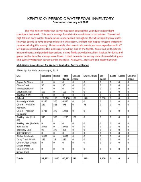
<strong>KENTUCKY</strong> <strong>PERIODIC</strong> <strong>WATERFOWL</strong> <strong>INVENTORY</strong><br />
Conducted January 4-9 2017<br />
The Mid-Winter Waterfowl survey has been delayed this year due to poor flight<br />
conditions last week. This year’s surveys found similar conditions to last winter. The record<br />
high fall and early winter temperatures experienced throughout the Mississippi Flyway states<br />
this year seems to have delayed migration this season, and left high hopes for good waterfowl<br />
numbers during this survey. Unfortunately, the recent rain events we have experienced in KY<br />
left birds scattered across the landscape for all but one of the flights. Moist soil units, beaver<br />
impoundments and ponded depressions in crop fields provided excellent habitat for ducks and<br />
geese on the days the surveys were flown. Listed below is the survey data obtained during our<br />
Mid-Winter Waterfowl Survey across the state. As always… stay safe and happy hunting!<br />
Mid-Winter Survey Report for Western Kentucky - Purchase Region<br />
Flown by: Pat Hahs on January 4, 2017<br />
Site Dabblers Divers Total<br />
Ducks<br />
Canada<br />
geese<br />
Snows/Blues WF<br />
Geese<br />
Coots Eagles Sandhill<br />
Crane<br />
Bayou De Chien 0 0 0 0 0 0 0 0 0<br />
Obion Creek 50 0 50 0 0 0 0 0 0<br />
Mississippi River 0 0 0 0 0 0 0 0 0<br />
Mayfield Creek 190 0 190 0 0 0 0 0 0<br />
Reelfoot NWR 0 0 0 0 0 0 0 0 0<br />
Ballard 22,300 150 22,450 120 140 2,200 0 0 0<br />
Boatwright WMA 4,270 300 4,570 0 0 0 0 0 0<br />
Ohio R. (Wickliffe- 150 325 475 0 75 0 0 0 0<br />
Paducah)<br />
Ohio R. (Paducah- 4,711 370 5,081 0 0 0 0 0 0<br />
Golconda)<br />
Barkley Lake (N of 915 360 1,295 150 0 0 0 0 0<br />
68)<br />
Barkley Lake (S of 68) 0 0 0 0 0 0 0 0 0<br />
duck Island 2,055 0 2,055 0 0 0 0 0 0<br />
Kentucky Lake 98 370 468 0 0 0 0 0 0<br />
Kaler Bottoms 0 0 0 0 0 0 0 0 0<br />
Birdsville Islands 3,888 0 3,888 0 0 0 0 0 0<br />
Doug Travis WMA 195 25 220 0 0 0 0 0 0<br />
Obion Creek (Travis 0 0 0 0 0 0 0 0 0<br />
Slough tract)<br />
Obion Creek (L.E.<br />
Schaaf tract)<br />
0 0 0 0 0 0 0 0 0<br />
Totals 38,822 1,900 40,722 270 215 2,200 0 0 0
Notes from Pat… Waterfowl observations were generally normal for this time of year. We have<br />
experienced some very odd weather prior to the survey date. Temperatures were normal for the<br />
season on survey day, but we have experienced temperatures both 15-20 degrees above normal and 15-<br />
20 degrees below normal for extended periods this winter. Habitat conditions were pretty good,<br />
although we have had minimal major rain events leaving the big rivers and tributaries in moderate flow<br />
at most. No flood conditions were noted during the survey and the majority of water holes likely have<br />
been pumped. Species distribution is roughly consistent with early January other than an unusually high<br />
percentage of green-winged teal that be using duck island for several weeks. Some species such as<br />
goldeneye and canvasback normally associated with colder, mid-Winter weather were not observed in<br />
significant numbers.<br />
Lower Ohio River & Western Coalfield<br />
Flown by: Thomas Young on January 9, 2017<br />
Site Dabblers Divers Total<br />
Ducks<br />
Canada<br />
geese<br />
Snows/Blues WF<br />
Geese<br />
Coots Eagles Sandhill<br />
Crane<br />
Ohio R. (Owensboro- 270 5 275 175 0 0 0 0 0<br />
Green River)<br />
Ohio R. (Green River- 12 0 12 0 0 0 0 0 0<br />
Henderson)<br />
Ohio R. (Henderson- 0 0 0 0 0 0 0 0 0<br />
Sloughs WMA)<br />
Sloughs WMA 14,410 525 14,935 1,851 400 8,123 200 3 0<br />
Ohio R. (GPPL & 27 39 66 50 0 0 0 3 0<br />
JHHC)<br />
Ohio R. (Uniontown- 25 0 25 0 0 0 0 1 0<br />
Shawneetown)<br />
Ohio R.<br />
(Shawneetown-<br />
Tradewater R.)<br />
0 0 0 25 0 0 0 0 0<br />
Ohio R. (Tradewater 0 0 0 0 0 0 0 0 0<br />
R.-E. end of<br />
Hurricane Isl.)<br />
Ohio R. (Hurricane 70 25 95 24 0 0 0 4 0<br />
Isl.-Golconda)<br />
Hovey Lake WMA 1,006 25 1,031 12 0 0 0 0 0<br />
(Indiana)<br />
Pond River-White 483 0 483 0 0 0 200 4 0<br />
City WMA<br />
Tradewater River 511 120 631 50 0 0 0 0 0<br />
Peabody Coal<br />
Property<br />
3,840 673 4,513 1,143 0 0 50 1 0<br />
Totals 20,654 1,412 22,066 3,330 400 8,123 450 16 0
Rough River – Yellowbank WMA<br />
Flown by: Thomas Young on January 5, 2016<br />
Site Dabblers Divers Total Canada Snows/Blues WF Coots Eagles Sandhill<br />
Ducks geese<br />
Geese<br />
Crane<br />
Rough River 25 40 65 45 0 0 0 2 0<br />
Yellowbank WMA 59 0 59 0 0 0 0 0 0<br />
Ohio R. (Brandenburg 469 0 469 36 0 0 0 2 0<br />
- Owensboro)<br />
Totals 553 40 593 81 0 0 0 4 0<br />
Notes from Thomas… The Ohio River was at normal pool. Below freezing conditions were present over<br />
the region for several consecutive days before the survey. All shallow water impoundments were<br />
covered in ice except a couple holes kept open by waterfowl on Hovey Lake, Slough's Refuge and<br />
Peabody Refuge.<br />
Mid-Winter Survey Report for Central and Easterm KY<br />
Flown by: Josh Lilpop & Wes Little on January 4, 2017<br />
Site Dabblers Divers Total<br />
Ducks<br />
Canada<br />
geese<br />
Snows<br />
Blues<br />
WF<br />
Geese<br />
Coots Eagles Sandhill<br />
Crane<br />
Herrington Lake 50 0 50 50 0 0 0 0 0<br />
Cedar Creek Lake 760 0 760 0 0 0 0 3 0<br />
Lake Cumberland 114 0 114 85 0 0 0 0 0<br />
Dale Hollow Lake 1,493 101 1,594 0 0 0 0 0 0<br />
Barren River Lake 0 0 0 0 0 0 0 0 250<br />
Green River Lake 4 0 0 0 0 0 0 0 0<br />
Taylorsville Lake 7 0 0 0 0 0 0 1 0<br />
Central Ohio 422 0 422 708 0 0 0 0 0<br />
River<br />
Blue Grass Army 210 52 262 130 0 0 50 0 0<br />
Depot<br />
Licking River 62 0 62 33 0 0 0 1 0<br />
(Southern)<br />
Cave Run Lake 0 6 6 35 0 0 0 2 0<br />
Grayson Lake 36 0 36 33 0 0 0 0 0<br />
Yatesville Lake 0 0 0 46 0 0 0 0 0<br />
Ohio River- 14 0 14 12 0 0 0 0 0<br />
(Ashland to<br />
Scioto R.)<br />
Scioto River 77 14 91 0 0 0 0 0 0
Site Dabblers Divers Total<br />
Ducks<br />
Canada<br />
geese<br />
Snows<br />
Blues<br />
WF<br />
Geese<br />
Coots Eagles Sandhill<br />
Crane<br />
Ohio River 733 32 765 1088 0 0 0 1 0<br />
(Scioto R. to<br />
Licking R.)<br />
Licking River 9 0 9 171 0 0 0 0 0<br />
(Northern)<br />
Campbell County 0 0 0 0 0 0 0 0 0<br />
Lake<br />
Kincade Lake 0 0 0 86 0 0 0 0 0<br />
Totals 3,991 205 4,185 2,477 0 0 50 8 250<br />
Notes from Terri… The Central survey was conducted with clear sunny skies and mild winds