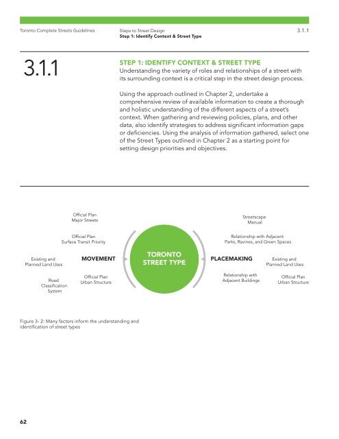
Toronto Complete Streets Guidelines Steps to Street Design Step 1: Identify Context & Street Type 3.1.1 3.1.1 STEP 1: IDENTIFY CONTEXT & STREET TYPE Understanding the variety of roles and relationships of a street with its surrounding context is a critical step in the street design process. Using the approach outlined in Chapter 2, undertake a comprehensive review of available information to create a thorough and holistic understanding of the different aspects of a street’s context. When gathering and reviewing policies, plans, and other data, also identify strategies to address significant information gaps or deficiencies. Using the analysis of information gathered, select one of the Street Types outlined in Chapter 2 as a starting point for setting design priorities and objectives. Official Plan Major Streets Streetscape Manual Official Plan Surface Transit Priority Relationship with Adjacent Parks, Ravines, and Green Spaces Existing and Planned Land Uses MOVEMENT TORONTO STREET TYPE PLACEMAKING Existing and Planned Land Uses Road Classification System Official Plan Urban Structure Relationship with Adjacent Buildings Official Plan Urban Structure Figure 3- 2: Many factors inform the understanding and identification of street types 62
Toronto Complete Streets Guidelines Steps to Street Design Step 1: Identify Context & Street Type 3.1.1 STEP 1: CHECKLISTS Identify the street’s “placemaking” context: Consult Official Plan policies and maps (eg, urban structure, land use designations, secondary plans or other area plans, heritage conservation plans, etc) Consult public realm and streetscape policies (e.g, Streetscape Manual, Vibrant Streets Guidelines, urban design guidelines, etc) Consult the Green Streets Technical Guidelines including policies, maps and the Low- Impact Design feature selection tool (eg, planting conditions, stormwater plans, tree canopy, etc). Identify grades, drainage, stormwater flow, catch basin locations, etc.) Is the street located in a Business Improvement Area (BIA) and are there streetscape or master plans? What are the street’s trip generators and destinations, e.g., schools, institutions, parks, etc.? Identify the past, present and future characteristics of the place and users of the street (e.g, cultural heritage, social history and new development). Research and identify any encroachment or easement agreements on the street segment. Identify the street’s “movement” context: Consult Official Plan policies, network plans and maps (e.g, rapid transit network, surface transit priority network, planned right-of-way widths, etc) Align with the City’s pedestrianrelated policies and obtain data, (e.g. existing and future volumes, trip generators, safety heat maps, walking conditions, OTM Book 15, etc.). Consult the Cycling Network Plan, OTM Book 18, and obtain data, e.g, existing and future volumes, trip generators, and safety conditions. Collect and review data (e.g. collisions, existing and future volumes, truck volumes, speed, and travel times) Identify curbside and operational uses (e.g. parking (on- and offstreet supply), deliveries, taxi stands, food trucks, bike parking, Bike Share stations, snow storage, etc). Review multimodal demand and connectivity. Consult Road Classification System. Identify existing street right-ofway widths and allocation of space. Identify profile of street users: Conduct site assessments and gather observational data What are the current and future demographics (e.g. seniors)? Who uses the street? Consider people of all ages, abilities and genders, and universal design. Identify activities and any permit holders (e.g, cafés, marketing displays, street vendors, food trucks, boulevard parking, filming, etc.). Consider all times of the day, different days of the week, and times of the year (all seasons) Consider anticipated routes for different users, and their desire lines (typical paths and destinations) Consider emergency services, operations and maintenance, and utilities (year-round, all times of day) Consider utilities and their location and placement, both above and below ground What consultation (e.g., public and stakeholder input and feedback) has been conducted on the above roles and users of the street, and the potential street type(s) that contribute to the street project’s objectives? Identify potential funders and maintenance partners. Identify street type(s): Which street type(s) are most similar to the aspirational role of the street (i.e., vision and goals)? 63