

Agro-climatic zonation for dry farming wheat in Zanjan Province, Iran
Abstract Climate knowledge and investigating in climatologic requirements of plants is considered as a most salient factor in cultivation. It can be determined the climatic potential conditions in the various regions and utilize them to a large extent by investigating in agro-meteorology. In this research, it has been applied the Geographic Information System to generate the climatic potential maps for Zanjan Province. To this purpose, the 30-year statistical records of climatology and synoptic stations have been used in the province of Zanjan. It was determined the date of cultivation for each section of the province after obtaining the beginning date of autumn precipitations for each part of the province. In the next step, the rainfall element was used for producing the isohyets climatic maps of annual rainfall, rainfall in the germination, blossoming, and ripe periods. The isotherm climatic maps of germination’s suitable temperature, thermal tensions during the blossoming, ripe periods were provided for the whole province. In the long run, the climatic potential regionalization map of dry-farming wheat was produced through overlying the relevant maps by GIS. The outputs showed the major suitable regions for dry-farming of wheat are in the South and Central areas of the province. In contrast, the regions located in the North of the province – upland and sharp steep regions of Alburz mountain chain - hold ordinary and feeble conditions in the light of wheat cultivation.
Abstract
Climate knowledge and investigating in climatologic requirements of plants is considered as a most salient factor in cultivation. It can be determined the climatic potential conditions in the various regions and utilize them to a large extent by investigating in agro-meteorology. In this research, it has been applied the Geographic Information System to generate the climatic potential maps for Zanjan Province. To this purpose, the 30-year statistical records of climatology and synoptic stations have been used in the province of Zanjan. It was determined the date of cultivation for each section of the province after obtaining the beginning date of autumn precipitations for each part of the province. In the next step, the rainfall element was used for producing the
isohyets climatic maps of annual rainfall, rainfall in the germination, blossoming, and ripe periods. The isotherm climatic maps of germination’s suitable temperature, thermal tensions during the blossoming, ripe periods were provided for the whole province. In the long run, the climatic potential regionalization map of dry-farming wheat was produced through overlying the relevant maps by GIS. The outputs showed the major suitable regions for
dry-farming of wheat are in the South and Central areas of the province. In contrast, the regions located in the North of the province – upland and sharp steep regions of Alburz mountain chain - hold ordinary and feeble conditions in the light of wheat cultivation.

You also want an ePaper? Increase the reach of your titles
YUMPU automatically turns print PDFs into web optimized ePapers that Google loves.
precipitations, and germ<strong>in</strong>at<strong>in</strong>g/bloom<strong>in</strong>g/full-grown<br />
precipitations), as well as temperature variables<br />
(proper temperature of germ<strong>in</strong>at<strong>in</strong>g, temperatures<br />
less than 9 o C <strong>in</strong> bloom<strong>in</strong>g, temperatures more than<br />
25 o C <strong>in</strong> bloom<strong>in</strong>g period, and temperatures less than<br />
9 o C <strong>in</strong> full-grown, and temperatures more than 30 o C<br />
<strong>in</strong> full-grown period). Appropriate condition <strong>for</strong><br />
w<strong>in</strong>tertime <strong>wheat</strong> cultivation is depend<strong>in</strong>g on two<br />
variables of precipitation and temperature. Because of<br />
be<strong>in</strong>g <strong>in</strong> a good condition the appropriate<br />
temperature <strong>for</strong> germ<strong>in</strong>at<strong>in</strong>g, <strong>in</strong> this paper we mostly<br />
emphasize on precipitation element and temperature<br />
is considered as a second factor.<br />
more than 5mm taken place <strong>for</strong> one or two<br />
consecutive days with a probability of 75% <strong>in</strong> fall<br />
season. As well as, proper temperatures <strong>for</strong> this<br />
period also were determ<strong>in</strong>ed between 12 o C to 20 o C. In<br />
cont<strong>in</strong>uation, concern<strong>in</strong>g the thermal requirements of<br />
<strong>wheat</strong> dur<strong>in</strong>g various grow<strong>in</strong>g phases, it was<br />
determ<strong>in</strong>ed the beg<strong>in</strong>n<strong>in</strong>g and end<strong>in</strong>g time of growth<br />
sensitive steps (germ<strong>in</strong>at<strong>in</strong>g/ bloom<strong>in</strong>g/ full-grown).<br />
Because the annual precipitation and its distribution<br />
is considered as the most important <strong>climatic</strong> variable<br />
<strong>in</strong> <strong>dry</strong>-<strong>farm<strong>in</strong>g</strong> <strong>wheat</strong>, the amount of annual<br />
precipitation of the prov<strong>in</strong>ce and its distribution <strong>in</strong><br />
different seasons and its value dur<strong>in</strong>g phases of<br />
germ<strong>in</strong>at<strong>in</strong>g/ bloom<strong>in</strong>g/ full-grown <strong>in</strong> the region was<br />
determ<strong>in</strong>ed by us<strong>in</strong>g GIS.<br />
Fig.5. Distribution of w<strong>in</strong>tertime precipitation’s<br />
ratio.<br />
Fig. 7. Average precipitation <strong>in</strong> the phase of<br />
bloom<strong>in</strong>g.<br />
Fig. 6. Average precipitation <strong>in</strong> the phase of<br />
germ<strong>in</strong>at<strong>in</strong>g.<br />
At the present research, as regards the region and<br />
importance of precipitation <strong>in</strong> <strong>dry</strong>-<strong>farm<strong>in</strong>g</strong>, the<br />
follow<strong>in</strong>g def<strong>in</strong>ition was applied to compute the date<br />
of cultivation: the first date of ra<strong>in</strong>fall occurrence and<br />
Hanafi et al.<br />
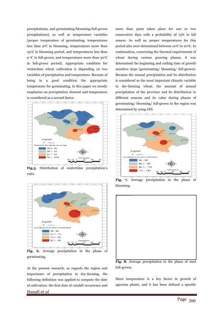
Fig. 8. Average precipitation <strong>in</strong> the phase of seed<br />
full-grown.<br />
S<strong>in</strong>ce temperature is a key factor <strong>in</strong> growth of<br />
agrarian plants, and it has been def<strong>in</strong>ed a specific<br />
Page 200

![Review on: impact of seed rates and method of sowing on yield and yield related traits of Teff [Eragrostis teff (Zucc.) Trotter] | IJAAR @yumpu](https://documents.yumpu.com/000/066/025/853/c0a2f1eefa2ed71422e741fbc2b37a5fd6200cb1/6b7767675149533469736965546e4c6a4e57325054773d3d/4f6e6531383245617a537a49397878747846574858513d3d.jpg?AWSAccessKeyId=AKIAICNEWSPSEKTJ5M3Q&Expires=1716944400&Signature=TpYn6jTuKH2Fe0KE%2BEdIDAnsnso%3D)


