

Agro-climatic zonation for dry farming wheat in Zanjan Province, Iran
Abstract Climate knowledge and investigating in climatologic requirements of plants is considered as a most salient factor in cultivation. It can be determined the climatic potential conditions in the various regions and utilize them to a large extent by investigating in agro-meteorology. In this research, it has been applied the Geographic Information System to generate the climatic potential maps for Zanjan Province. To this purpose, the 30-year statistical records of climatology and synoptic stations have been used in the province of Zanjan. It was determined the date of cultivation for each section of the province after obtaining the beginning date of autumn precipitations for each part of the province. In the next step, the rainfall element was used for producing the isohyets climatic maps of annual rainfall, rainfall in the germination, blossoming, and ripe periods. The isotherm climatic maps of germination’s suitable temperature, thermal tensions during the blossoming, ripe periods were provided for the whole province. In the long run, the climatic potential regionalization map of dry-farming wheat was produced through overlying the relevant maps by GIS. The outputs showed the major suitable regions for dry-farming of wheat are in the South and Central areas of the province. In contrast, the regions located in the North of the province – upland and sharp steep regions of Alburz mountain chain - hold ordinary and feeble conditions in the light of wheat cultivation.
Abstract
Climate knowledge and investigating in climatologic requirements of plants is considered as a most salient factor in cultivation. It can be determined the climatic potential conditions in the various regions and utilize them to a large extent by investigating in agro-meteorology. In this research, it has been applied the Geographic Information System to generate the climatic potential maps for Zanjan Province. To this purpose, the 30-year statistical records of climatology and synoptic stations have been used in the province of Zanjan. It was determined the date of cultivation for each section of the province after obtaining the beginning date of autumn precipitations for each part of the province. In the next step, the rainfall element was used for producing the
isohyets climatic maps of annual rainfall, rainfall in the germination, blossoming, and ripe periods. The isotherm climatic maps of germination’s suitable temperature, thermal tensions during the blossoming, ripe periods were provided for the whole province. In the long run, the climatic potential regionalization map of dry-farming wheat was produced through overlying the relevant maps by GIS. The outputs showed the major suitable regions for
dry-farming of wheat are in the South and Central areas of the province. In contrast, the regions located in the North of the province – upland and sharp steep regions of Alburz mountain chain - hold ordinary and feeble conditions in the light of wheat cultivation.

Create successful ePaper yourself
Turn your PDF publications into a flip-book with our unique Google optimized e-Paper software.
Fig. 13. Temperatures more than 30 o C <strong>in</strong> the phase<br />
of full-grown.<br />
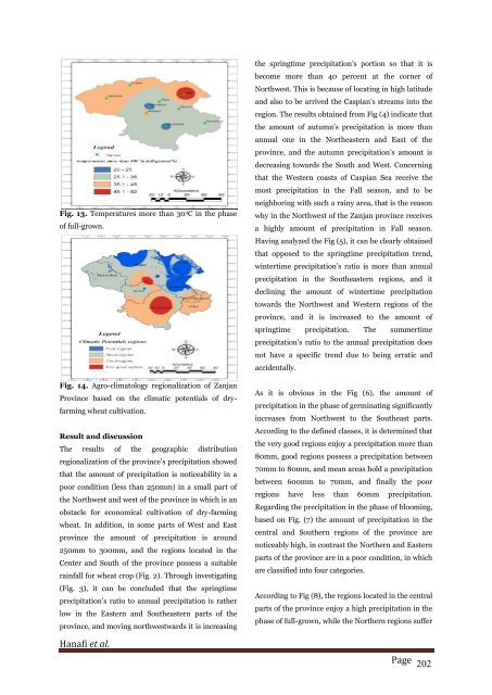
Fig. 14. <strong>Agro</strong>-climatology regionalization of <strong>Zanjan</strong><br />
Prov<strong>in</strong>ce based on the <strong>climatic</strong> potentials of <strong>dry</strong><strong>farm<strong>in</strong>g</strong><br />
<strong>wheat</strong> cultivation.<br />
Result and discussion<br />
The results of the geographic distribution<br />
regionalization of the prov<strong>in</strong>ce’s precipitation showed<br />
that the amount of precipitation is noticeability <strong>in</strong> a<br />
poor condition (less than 250mm) <strong>in</strong> a small part of<br />
the Northwest and west of the prov<strong>in</strong>ce <strong>in</strong> which is an<br />
obstacle <strong>for</strong> economical cultivation of <strong>dry</strong>-<strong>farm<strong>in</strong>g</strong><br />
<strong>wheat</strong>. In addition, <strong>in</strong> some parts of West and East<br />
prov<strong>in</strong>ce the amount of precipitation is around<br />
250mm to 300mm, and the regions located <strong>in</strong> the<br />
Center and South of the prov<strong>in</strong>ce possess a suitable<br />
ra<strong>in</strong>fall <strong>for</strong> <strong>wheat</strong> crop (Fig. 2). Through <strong>in</strong>vestigat<strong>in</strong>g<br />
(Fig. 3), it can be concluded that the spr<strong>in</strong>gtime<br />
precipitation’s ratio to annual precipitation is rather<br />
low <strong>in</strong> the Eastern and Southeastern parts of the<br />
prov<strong>in</strong>ce, and mov<strong>in</strong>g northwestwards it is <strong>in</strong>creas<strong>in</strong>g<br />
the spr<strong>in</strong>gtime precipitation’s portion so that it is<br />
become more than 40 percent at the corner of<br />
Northwest. This is because of locat<strong>in</strong>g <strong>in</strong> high latitude<br />
and also to be arrived the Caspian’s streams <strong>in</strong>to the<br />
region. The results obta<strong>in</strong>ed from Fig (4) <strong>in</strong>dicate that<br />
the amount of autumn’s precipitation is more than<br />
annual one <strong>in</strong> the Northeastern and East of the<br />
prov<strong>in</strong>ce, and the autumn precipitation’s amount is<br />
decreas<strong>in</strong>g towards the South and West. Concern<strong>in</strong>g<br />
that the Western coasts of Caspian Sea receive the<br />
most precipitation <strong>in</strong> the Fall season, and to be<br />
neighbor<strong>in</strong>g with such a ra<strong>in</strong>y area, that is the reason<br />
why <strong>in</strong> the Northwest of the <strong>Zanjan</strong> prov<strong>in</strong>ce receives<br />
a highly amount of precipitation <strong>in</strong> Fall season.<br />
Hav<strong>in</strong>g analyzed the Fig (5), it can be clearly obta<strong>in</strong>ed<br />
that opposed to the spr<strong>in</strong>gtime precipitation trend,<br />
w<strong>in</strong>tertime precipitation’s ratio is more than annual<br />
precipitation <strong>in</strong> the Southeastern regions, and it<br />
decl<strong>in</strong><strong>in</strong>g the amount of w<strong>in</strong>tertime precipitation<br />
towards the Northwest and Western regions of the<br />
prov<strong>in</strong>ce, and it is <strong>in</strong>creased to the amount of<br />
spr<strong>in</strong>gtime precipitation. The summertime<br />
precipitation’s ratio to the annual precipitation does<br />
not have a specific trend due to be<strong>in</strong>g erratic and<br />
accidentally.<br />
As it is obvious <strong>in</strong> the Fig (6), the amount of<br />
precipitation <strong>in</strong> the phase of germ<strong>in</strong>at<strong>in</strong>g significantly<br />
<strong>in</strong>creases from Northwest to the Southeast parts.<br />
Accord<strong>in</strong>g to the def<strong>in</strong>ed classes, it is determ<strong>in</strong>ed that<br />
the very good regions enjoy a precipitation more than<br />
80mm, good regions possess a precipitation between<br />
70mm to 80mm, and mean areas hold a precipitation<br />
between 600mm to 70mm, and f<strong>in</strong>ally the poor<br />
regions have less than 60mm precipitation.<br />
Regard<strong>in</strong>g the precipitation <strong>in</strong> the phase of bloom<strong>in</strong>g,<br />
based on Fig. (7) the amount of precipitation <strong>in</strong> the<br />
central and Southern regions of the prov<strong>in</strong>ce are<br />
noticeably high, <strong>in</strong> contrast the Northern and Eastern<br />
parts of the prov<strong>in</strong>ce are <strong>in</strong> a poor condition, <strong>in</strong> which<br />
are classified <strong>in</strong>to four categories.<br />
Accord<strong>in</strong>g to Fig (8), the regions located <strong>in</strong> the central<br />
parts of the prov<strong>in</strong>ce enjoy a high precipitation <strong>in</strong> the<br />
phase of full-grown, while the Northern regions suffer<br />
Hanafi et al.<br />
Page 202

![Review on: impact of seed rates and method of sowing on yield and yield related traits of Teff [Eragrostis teff (Zucc.) Trotter] | IJAAR @yumpu](https://documents.yumpu.com/000/066/025/853/c0a2f1eefa2ed71422e741fbc2b37a5fd6200cb1/6b7767675149533469736965546e4c6a4e57325054773d3d/4f6e6531383245617a537a49397878747846574858513d3d.jpg?AWSAccessKeyId=AKIAICNEWSPSEKTJ5M3Q&Expires=1716944400&Signature=TpYn6jTuKH2Fe0KE%2BEdIDAnsnso%3D)


