1.3 MB - Instituto de Ciencias de la Tierra Jaume Almera
1.3 MB - Instituto de Ciencias de la Tierra Jaume Almera
1.3 MB - Instituto de Ciencias de la Tierra Jaume Almera

Create successful ePaper yourself
Turn your PDF publications into a flip-book with our unique Google optimized e-Paper software.
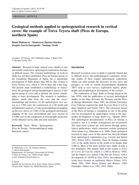
Carbonates Evaporites (2011) 26:29–40<br />
DOI 10.1007/s13146-011-0052-7<br />
ORIGINAL ARTICLE<br />
Geological methods applied to speleogenetical research in vertical<br />
caves: the example of Torca Teyera shaft (Picos <strong>de</strong> Europa,<br />
northern Spain)<br />
Daniel Ballesteros • Montserrat Jiménez-Sánchez •<br />
Joaquín García-Sansegundo • Santiago Giralt<br />
Accepted: 19 February 2011 / Published online: 5 March 2011<br />
Ó Springer-Ver<strong>la</strong>g 2011<br />
Abstract Research in <strong>la</strong>rge vertical caves (shafts) is rare<br />
and usually restricted to speleological explorations because<br />
of difficult access. The systemic methodology of work in<br />
shafts has not been established. Picos <strong>de</strong> Europa massif, in<br />
the Cantabrian Mountains of Spain, has a spectacu<strong>la</strong>r<br />
<strong>de</strong>velopment of shafts <strong>de</strong>eper than 500 m. One of them is<br />
Torca Teyera cave, which is 738 m <strong>de</strong>ep and 4 km long.<br />
The present study established a methodology to characterize<br />
the geological and geomorphological aspects of this<br />
special group of caves and to i<strong>de</strong>ntify the factors contributing<br />
to karst <strong>de</strong>velopment. The research is multidisciplinary,<br />
needs data from the cave and the caves’<br />
surroundings and involves (1) the speleological cave survey<br />
at a 1:500 scale: the construction of a 3D mo<strong>de</strong>l and<br />
morphometric analyses; (2) the geomorphological mapping<br />
on the cave survey at 1:500; (3) the geological and fracture<br />
mapping of the cave environment and cross section at<br />
1:5.000; and (4) the comparison in stereographic projection<br />
of the obtained survey data and joint measures.<br />
Keywords Karst Shafts Speleogenesis<br />
Picos <strong>de</strong> Europa Geomorphological maps<br />
Structural control<br />
D. Ballesteros (&) M. Jiménez-Sánchez<br />
J. García-Sansegundo<br />
Departamento <strong>de</strong> Geología, Universidad <strong>de</strong> Oviedo,<br />
C/Arias <strong>de</strong> Ve<strong>la</strong>sco s/n, 33005 Oviedo, Spain<br />
e-mail: ballesteros@geol.uniovi.es<br />
S. Giralt<br />
<strong>Instituto</strong> <strong>de</strong> <strong>la</strong>s <strong>Ciencias</strong> <strong>de</strong> <strong>la</strong> <strong>Tierra</strong> <strong>Jaume</strong> <strong>Almera</strong> (CSIC),<br />
C/Lluís Solé i Sabarís s/n, 08028 Barcelona, Spain<br />
Introduction<br />
Research in vertical caves or shafts is typically limited due<br />
to difficult access and methodological constraints. Scientific<br />
studies of these require speleological exploration,<br />
which can often inclu<strong>de</strong> the discovery of new caves and<br />
passages, as well as careful documentation (Kambesis<br />
2007) such as cave surveys, exploration reports, photographs<br />
and morphological <strong>de</strong>scriptions of the cavities.<br />
The exploration of <strong>la</strong>rge shafts in Europe began in the<br />
<strong>la</strong>te 1970s with the publication of several speleological<br />
studies on the Alps, Slovenia, the Pyrenees and the Picos<br />
<strong>de</strong> Europa Mountains. Since 1981, the Oxford University<br />
Cave Club has explored the shaft Pozu <strong>de</strong>l H.itu (1,135 m<br />
<strong>de</strong>ep; Singleton and Naylor 1981). The calcareous massif<br />
of the Picos <strong>de</strong> Europa is consi<strong>de</strong>red as one of the prime<br />
sites for investigation by speleologists owing to the spectacu<strong>la</strong>r<br />
<strong>de</strong>velopment of <strong>la</strong>rge shafts (e.g., Ogando 2007).<br />
The speleological documentation in Picos <strong>de</strong> Europa is<br />
extensive, but it is neither systematized nor inventoried.<br />
The main karst systems are well known through speleological<br />
publications, which sometimes inclu<strong>de</strong> geological<br />
observations (e.g., Erhey<strong>de</strong>n et al. 2008). Some geological<br />
research in <strong>la</strong>rge caves of this massif has been <strong>de</strong>veloped<br />
from speleological explorations (e.g., Laverty and Senior<br />
1981; Senior 1987). Currently, Picos <strong>de</strong> Europa contains<br />
13% of the shafts known in the world to be <strong>de</strong>eper than<br />
1,000 m. Most of the karst systems have shafts of only a<br />
few kilometers. The <strong>de</strong>epest shaft in this system is Torca<br />
<strong>de</strong>l Cerro <strong>de</strong>l Cuevón, which is 1,589 m (Estévez 1998),<br />
and the <strong>la</strong>rgest cave system is the Red <strong>de</strong>l Toneyu, with a<br />
<strong>de</strong>velopment of 18,970 m (Gea 1991). Nevertheless, few<br />
works have focused on endokarsts (Hoyos Gómez 1979;<br />
Smart 1984, 1986; Hoyos Gómez and Herrero, 1989;<br />
Fernán<strong>de</strong>z- Gibert et al. 1992, 1994, 2000).<br />
123
30 Carbonates Evaporites (2011) 26:29–40<br />
The present study documents a methodological<br />
approach useful for the geological and geomorphological<br />
characterization of these special environments and discusses<br />
the conditioning of karst <strong>de</strong>velopment.<br />
Setting<br />
Torca Teyera is a <strong>la</strong>rge shaft, 738 m <strong>de</strong>ep, located on<br />
the northern part of the Picos <strong>de</strong> Europa (Fig. 1), a<br />
mountain massif located in the Cantabrian Mountains of<br />
northern Spain. From the structural standpoint, Picos <strong>de</strong><br />
Europa belongs to the Cantabrian Zone of the Varisci<strong>de</strong>s<br />
domain (Lotze 1945; Julivert et al. 1972; Alonso et al.<br />
2009). The bedrock consists mainly of 1,200 m of carboniferous<br />
limestone affected by E–W to NW–SE and<br />
south-directed imbricate variscan system thrust (Fig. 2).<br />
The décollement level of the structures is above silicic<strong>la</strong>stic<br />
rocks from the Pisuerga-Carrión province (Pérez-<br />
Estaún et al. 1988; Marquínez 1989; Farias and Heredia<br />
1994; Bahamon<strong>de</strong> et al. 2007; Merino-Tomé et al. 2009).<br />
During the Alpine orogeny, some of these thrusts were<br />
reactivated, causing the rotation of some thrust sheets<br />
Fig. 1 Situation map of the<br />
Picos <strong>de</strong> Europa massif. The<br />
locations of the cave of study<br />
(Torca Teyera, Fig. 5) are also<br />
shown<br />
123<br />
and leading to the formation of the main relief<br />
(Alonso et al. 1996; Pulgar et al. 1999; Gal<strong>la</strong>stegui<br />
Suárez 2000).<br />
Picos <strong>de</strong> Europa is characterized by a rough and calcareous<br />
relief with peaks exceeding 2,500 m above sea<br />
level (asl) and by the presence of narrow canyons, such as<br />
the Cares Gorge. Canyons up to 2,000-m <strong>de</strong>ep evi<strong>de</strong>nce the<br />
important fluvial incision <strong>de</strong>rived from uplifting. The karst<br />
forms dominate the <strong>la</strong>ndscape (Hoyos Gómez 1979; Smart<br />
1984, 1986; Hoyos Gómez and Herrero 1989; Santos<br />
Alonso and Marquínez García, 2005), although g<strong>la</strong>cial and<br />
perig<strong>la</strong>cial features are preserved (Alonso 1991; González<br />
Suárez and Alonso 1994; Gale and Hoare 1997; Alonso<br />
1998; Jiménez-Sánchez and Farias Arquer 2002; González<br />
Trueba 2006, 2007; Moreno et al. 2009; Serrano Cañadas<br />
and González Trueba 2004). Moreover, nival, gravity and<br />
fluviotorrential processes also control the geomorphological<br />
evolution of the <strong>la</strong>ndscape.<br />
Torca Teyera shaft was discovered, explored and surveyed<br />
by the Groupe Spéléo du Doubs, the Société Suisse<br />
<strong>de</strong> Spéléo-Section <strong>de</strong> Genève, the Société <strong>de</strong>s Amateurs <strong>de</strong>s<br />
Caverns and the Spéléo Club of Nyon between 1979<br />
and 1982 (Borreguero 1986). During these explorations,
Carbonates Evaporites (2011) 26:29–40 31<br />
Fig. 2 Geological map of Picos <strong>de</strong> Europa (after Martínez García and Rodríguez Fernán<strong>de</strong>z 1984; Marquínez 1989; Merino-Tomé et al. 2009).<br />
Location of Torca Teyera (Fig. 5) is shown<br />
Borreguero (1986) prepared the first karst research presenting<br />
the structural control and cave <strong>de</strong>velopment. From<br />
2007 to 2009, 2,700 m of new cave passages were<br />
discovered by the Asociación Deportiva GEMA. At the<br />
present, Torca Teyera has 4 km of known passages<br />
reaching a <strong>de</strong>pth of 738 m.<br />
123
32 Carbonates Evaporites (2011) 26:29–40<br />
Methodology<br />
The present methodology inclu<strong>de</strong>s multidisciplinary<br />
observations to obtain both surficial data and data from the<br />
un<strong>de</strong>rground of the cave. The method is adapted to attain<br />
access to the shaft, which is difficult, and is based on speleological<br />
(Butcher 1950), geomorphological and structural<br />
geology techniques (Alonso et al. 1999; Jiménez-Sánchez<br />
et al. 2004, 2005, 2006). The method inclu<strong>de</strong>s the <strong>de</strong>finition<br />
of an area of 12 km 2 (Figs. 1, 2) including the cave<br />
and its surroundings: (1) the speleological survey at a 1:500<br />
scale; (2) the geomorphological mapping of the cave at a<br />
scale of 1:500 and surrounding of the cavity at a 1:5,000<br />
scale; and (3) the structural study that inclu<strong>de</strong>s the geological<br />
and fracture mapping at a 1:5,000 scale, the cross<br />
section, rose diagram analyses and the <strong>de</strong>finition of the<br />
joints families on stereographic projection.<br />
Cave survey and morphometric analyses<br />
The cave survey that corresponds to the Torca Teyera shaft<br />
is the cave projection in a horizontal p<strong>la</strong>ne. The survey was<br />
mapped using the speleological c<strong>la</strong>ssical method at a 1:500<br />
scale where successive stations were <strong>de</strong>fined in the passages.<br />
Distances, orientation and dip data were measured<br />
between stations using a tape measure or <strong>la</strong>ser, a ruler and a<br />
clinometer, respectively. The cavity survey was ma<strong>de</strong> by<br />
consi<strong>de</strong>ring a reference level between 30 cm and 1.5 m<br />
above the cave floor. The collected data were managed<br />
using the VisualTopo.503 software program (David 2009)<br />
to <strong>de</strong>fine the survey line (a line connecting the stations).<br />
The survey is conducted over the survey line consulting the<br />
sketches ma<strong>de</strong> during the data collection phase. The<br />
VisualTopo.503 software produces a 3D mo<strong>de</strong>l approximating<br />
the passages by an octagonal conduit, the axes of<br />
which are the height and width of the passages.<br />
The morphometric analyses consist of the representation<br />
of the survey data on stereographic projection, a common<br />
structural technique applied to compile figures on the<br />
direction and dip of the cave passages. The orientation and<br />
inclination data are represented on the plot per meter of<br />
surveyed cave. Afterward, a <strong>de</strong>nsity analysis is ma<strong>de</strong> and<br />
the main groups of passages established according to this<br />
direction and dip.<br />
Geomorphological research<br />
The geomorphological research inclu<strong>de</strong>s geomorphological<br />
mapping of both cave and cavity surroundings. Cave geomorphological<br />
mapping was carried out at a 1:500 scale,<br />
taking the cave survey as a topographical basis. Cavity<br />
features were inventoried and c<strong>la</strong>ssified according to<br />
genetic, morphological and sedimentary criteria (Jiménez-<br />
123<br />
Sánchez et al. 2006; Ford and Williams 2007). Sometimes,<br />
the geomorphological mapping and the survey were performed<br />
simultaneously. The limits of the different features<br />
were established and projected on the survey map. Some of<br />
the geomorphological elements located in the cave walls<br />
could not be represented by projecting them on the survey,<br />
since the survey had to be ma<strong>de</strong> at different heights above<br />
the ground. This problem was due to the difficulties in<br />
establishing objectively the boundary between the floor and<br />
the wall of the cave. Therefore, the geomorphological<br />
elements are shown schematically on the outsi<strong>de</strong> contour of<br />
the passages to minimize these problems. These elements<br />
were brought down on the walls along an axis located on<br />
the edge of the passages.<br />
A geomorphologic mapping of the cave surroundings<br />
was charted at a 1,500 scale using field observations and<br />
photo interpretation. This map covers a surface of 12 km 2<br />
and inclu<strong>de</strong>s different <strong>la</strong>ndscape features that are c<strong>la</strong>ssified<br />
according to genetic criteria (Martín-Serrano et al. 2004) in<br />
karstic, g<strong>la</strong>cial, snow, perig<strong>la</strong>cial, gravity and mixed forms.<br />
This map also inclu<strong>de</strong>s the entrances of the caves and the<br />
projection of their passages that have been explored by the<br />
speleologists (Borreguero 1986; Carbajal Rodríguez and<br />
Saiz Barreda 2003); Carbajal et al. 2008; Ballesteros et al.<br />
2009, 2010).<br />
Geological mapping and structural analyses<br />
The geological and fracture maps, covering a combined<br />
total surface of 12 km 2 (Fig. 2), were produced at a<br />
1:5,000 scale by means of field work and photo interpretation.<br />
Three geological cross sections were also prepared.<br />
The cavity study and others were projected over<br />
the maps and over the geological cross sections. Rose<br />
diagram from the data of the fracture map was prepared to<br />
compare with a rose diagram obtained from the orientation<br />
of the cave passages. Furthermore, 157 joint data<br />
measures (dip and direction) were taken on the surface<br />
(124) and in the shaft (33). These data were represented<br />
on stereographic projection and a <strong>de</strong>nsity analysis was<br />
ma<strong>de</strong>. The analysis of <strong>de</strong>nsities allows the establishment<br />
of joint families in which the median p<strong>la</strong>ne is illustrated<br />
in the plot with the bedding. Afterward, the <strong>de</strong>nsity plot of<br />
the orientation and dip of the passages were represented<br />
on the stereographic projection to compare the control of<br />
the joints and the bedding with the direction and inclination<br />
of the passages.<br />
Results and discussion<br />
The application of the methods <strong>de</strong>scribed above obtained<br />
the following results.
Carbonates Evaporites (2011) 26:29–40 33<br />
Cave survey and morphometric analyses<br />
The cave survey and the 3D mo<strong>de</strong>l are shown in Fig. 3.<br />
The cavity consists of three levels of galleries (horizontal<br />
passages) and several pits (vertical passages). The galleries<br />
represent 72% of the <strong>de</strong>velopment of the cave and are<br />
narrow mean<strong>de</strong>rs up to 50 m that join as tributaries and<br />
converge to the NE. Thus, the cavity is a branchwork cave<br />
<strong>de</strong>fined by Palmer (1991). The passages follow the NW–SE<br />
and NE–SW direction in the northern part of the cavity and<br />
the N–S and E–O trend in the southern area.<br />
The groups of passages according to their orientation<br />
and dip were <strong>de</strong>terminate by the representation of the<br />
survey data on stereographic projection. This approximation<br />
is sufficient for passages, but not fully a<strong>de</strong>quate for<br />
shafts because the survey <strong>de</strong>pends on the track of the<br />
speleologists. Therefore, a part of the subvertical measures<br />
does not represent subvertical passages. This fact has been<br />
taken into account for the interpretation of data. Four<br />
groups of passages were established and the median value<br />
of the direction and dip are: (1) subvertical, (2) N10°W/<br />
20°NW, (3) N45°E/20°NE and (4) N125°E/0°.<br />
Cave geomorphological mapping<br />
A selected portion of the geomorphological map of the<br />
southern sector of the shaft is illustrated in Fig. 4. The<br />
legend of the map is divi<strong>de</strong>d into three parts: issues re<strong>la</strong>ted<br />
to (1) the survey, (2) geomorphological features and (3)<br />
geological aspects. The first group inclu<strong>de</strong>s morphometric<br />
data re<strong>la</strong>ted to the passages: contour (using the upper and<br />
lower contour when there is an over<strong>la</strong>p), scarps and pits,<br />
presence of rivers or <strong>la</strong>kes, the slope of the ground and the<br />
value of altitu<strong>de</strong> and <strong>de</strong>pth from the cave entrance at<br />
several points. The position of possible continuations of<br />
Fig. 3 a The cave survey and<br />
b the 3D mo<strong>de</strong>l of Torca<br />
Teyera. The study location<br />
<strong>de</strong>scribed in Fig. 4 is shown<br />
cave passages is also shown. The group of geomorphological<br />
features inclu<strong>de</strong>s (1) speleothems, (2) fluviokarst<br />
and (3) gravity forms. Speleothems are c<strong>la</strong>ssified into<br />
dripstones, flowstones, and mixed and other forms. Dripstone<br />
forms inclu<strong>de</strong> sta<strong>la</strong>gmites, sta<strong>la</strong>ctites and columns.<br />
The flowstones present as casca<strong>de</strong>s and <strong>la</strong>minar forms. The<br />
mixed forms inclu<strong>de</strong> sta<strong>la</strong>gmite masses that originated by<br />
drip and flow of water (Fig. 4a). Other peculiar forms such<br />
as pool <strong>de</strong>posits or col<strong>la</strong>roids forms are noted. The fluviokarst<br />
forms are c<strong>la</strong>ssified as erosive forms or sedimentation<br />
forms. The erosive forms inclu<strong>de</strong> scallops, roof<br />
pendants, corrosion notches, solution runnels, potholes and<br />
relict channels. The erosive forms are mostly located in<br />
active and canyon shaped passages, shafts and at higher<br />
levels, such as relict forms (Fig. 4b). The fluvial <strong>de</strong>posits<br />
are divi<strong>de</strong>d into <strong>de</strong>posits of the active stream channel and<br />
the fluvial terrace (Fig. 4c). These <strong>de</strong>posits have been<br />
c<strong>la</strong>ssified according to the grain size as pebbles, sand and<br />
pebbles, sand, and c<strong>la</strong>y and mud. Finally, the gravity forms<br />
are <strong>de</strong>bris <strong>de</strong>posits, fallen boul<strong>de</strong>rs and single pebbles and<br />
gravel that have been shed by rockfall processes (Varnes<br />
1978). The breakdown <strong>de</strong>posits cover or are covered by<br />
other fluvial and precipitation <strong>de</strong>posits. The geomorphological<br />
map also inclu<strong>de</strong>s other remarkable geological<br />
aspects: quartz, galena and ma<strong>la</strong>chite mineralizations,<br />
altered substrate, structural data and volcanic rocks.<br />
Geomorphological mapping of the cave surrounding<br />
Torca Teyera is located un<strong>de</strong>r a free and half-exposed<br />
karren, dominated by karstic, g<strong>la</strong>cial and nival activity. The<br />
geomorphologic map of the cave surroundings is shown in<br />
Fig. 5a. The distribution of the geomorphological features<br />
is uneven. The <strong>de</strong>posits represent 27.3% of the area of<br />
study and are mainly situated in the valleys. The erosive<br />
123
34 Carbonates Evaporites (2011) 26:29–40<br />
Fig. 4 Details from a selected<br />
portion of the cave<br />
geomorphology map, its legend<br />
and pictures of different<br />
passages. Inset a represents a<br />
gallery shaped like a canyon,<br />
b a sta<strong>la</strong>gmite mass and<br />
c terrace <strong>de</strong>posits formed by<br />
levels of mud and sand<br />
123
Carbonates Evaporites (2011) 26:29–40 35<br />
Fig. 5 a Geomorphological<br />
map, b geological map and<br />
c fracture map of Torca Teyera<br />
area. The shaft is projected on<br />
maps and cross section of<br />
Fig. 6a. The data of the caves<br />
are from Borreguero (1986),<br />
Carbajal Rodríguez and Saiz<br />
Barreda (2003), Carbajal et al.<br />
(2008), Ballesteros et al. (2009,<br />
2010)<br />
forms have been i<strong>de</strong>ntified at the hillsi<strong>de</strong> and the peaks.<br />
The closed <strong>de</strong>pressions occupy 5.0% and are <strong>de</strong>veloped on<br />
slopes up to 40°.<br />
Karstic, snow, g<strong>la</strong>cial, perig<strong>la</strong>cial and gravity forms<br />
were mapped. The former inclu<strong>de</strong>s karstic <strong>de</strong>posits,<br />
dolines, g<strong>la</strong>ciokarst <strong>de</strong>pressions, caves and cave passages<br />
projections. The karst <strong>de</strong>posits are situated in the areas<br />
without slope and are mainly formed by mud that comes<br />
from the dissolution of the limestone. The sinkholes are<br />
<strong>de</strong>pressions of 5- to 20-m wi<strong>de</strong> and 1- to 5-m <strong>de</strong>pth and<br />
associated with gravitational <strong>de</strong>posits. The dolines are<br />
closed and dominated by breakdown processes; thus, they<br />
are mostly col<strong>la</strong>psed sinkholes. The g<strong>la</strong>ciokarst <strong>de</strong>pressions<br />
are closed hollows of 600-m wi<strong>de</strong> and 70-m <strong>de</strong>pth located<br />
123
36 Carbonates Evaporites (2011) 26:29–40<br />
at the valley bottom. The <strong>de</strong>pressions originated from<br />
g<strong>la</strong>cial, karstical and snow activity (Smart 1986; Alonso<br />
1998). The entrances of caves are mainly situated in<br />
sinkholes or g<strong>la</strong>ciokarst <strong>de</strong>pression and represent cave<br />
passages truncated by erosion. Torca Teyera is located<br />
un<strong>de</strong>r a free karren with a lot of closed <strong>de</strong>pressions, gravity<br />
<strong>de</strong>posits and some g<strong>la</strong>cier cirques.<br />
The nivation forms inclu<strong>de</strong> one moraine and some cirques<br />
originated by snow activity. The nivation cirques are<br />
observed in some walls of dolines and in scarps oriented to<br />
the NE or SW. The snow moraine is located un<strong>de</strong>r one<br />
nival cirque. G<strong>la</strong>cial forms cover till <strong>de</strong>posits, horns, arête,<br />
cirques and moraines. A g<strong>la</strong>cial valley is observed in the<br />
NW of Torca Teyera shaft. Till <strong>de</strong>posits, mainly formed by<br />
limestone pebbles and boul<strong>de</strong>rs, sand and mud, are found<br />
in this valley. In some cases, boul<strong>de</strong>rs of limestone in<br />
certain facies are found on the bedrock of limestone with<br />
other facies. The till is often presented in moraines of 1- to<br />
6-m wi<strong>de</strong> and 50- to 60-m long. The horns are <strong>de</strong>gra<strong>de</strong>d<br />
and are situated in the peaks where some arêtes converge.<br />
The cirques are greatly <strong>de</strong>gra<strong>de</strong>d by karstification and their<br />
size is between 100 and 300 m. The only perig<strong>la</strong>cial evi<strong>de</strong>nce<br />
is a rock g<strong>la</strong>cier shown on the eastern part of the<br />
map. The <strong>de</strong>posit is formed by limestone gravels and<br />
boul<strong>de</strong>rs, and presents some transverse and longitudinal<br />
ridges and furrows.<br />
Gravitational forms inclu<strong>de</strong> <strong>de</strong>bris fall, talus <strong>de</strong>posits<br />
and rock ava<strong>la</strong>nches and are situated un<strong>de</strong>r scarps and in<br />
sinkholes. The <strong>de</strong>bris fall generally consists of angu<strong>la</strong>r<br />
pebbles and gravels of limestone. The talus <strong>de</strong>posits are<br />
mostly formed of limestone pebbles and gravel, sand and<br />
mud; these are usually vegetated. The rock ava<strong>la</strong>nches are<br />
formed from disorganization of angu<strong>la</strong>r boul<strong>de</strong>rs and<br />
pebbles of limestone in the NE of the map.<br />
Some geomorphological features (till, closed <strong>de</strong>pressions,<br />
cirques, arêtes, gravity <strong>de</strong>posits and the rock g<strong>la</strong>cier)<br />
are mainly orientated following the NW–SE and NE–SW<br />
directions. This trend represents the orientation of the<br />
bedding, thrusts and the main faults.<br />
Geologic mapping and structural research<br />
The cavity surrounding of the geological map was formed<br />
by both the cave <strong>de</strong>velopment and the tectonics (Fig. 5b).<br />
The surroundings of Torca Teyera were formed by 1,000 m<br />
of limestone of the Val<strong>de</strong>teja and Picos <strong>de</strong> Europa Formations<br />
stacked vertically. The limestone is divi<strong>de</strong>d into<br />
three strata domain as <strong>de</strong>fined by Bahamon<strong>de</strong> et al. (2007):<br />
(1) toe of slope and basin facies, (2) slopes facies and (3)<br />
p<strong>la</strong>tform top facies. The toe of slope and basin facies<br />
inclu<strong>de</strong> well-stratified coarse-grained beds formed by<br />
breccias, bioc<strong>la</strong>stic pack to grainstone limestone, chert and<br />
shales. The slopes facies consist of massive limestone,<br />
123<br />
breccias and boundstone with botryoidal cement fans. The<br />
p<strong>la</strong>tform top facies inclu<strong>de</strong> stratification rocks, mainly<br />
formed by skeletal pack, to grainstone limestone and pink<br />
fossil-rich limestone. Moreover, an an<strong>de</strong>sitic dyke is recognized<br />
in the western middle part of the geological map.<br />
The cavity studied is <strong>de</strong>veloped on limestone affected by<br />
an NW–SE trending, subvertical and SW-directed thrusts<br />
and other faults, the direction of which is SE–NW, SW–NE<br />
or N–S (Figs. 5b, 6a). Two sequences of thrusts have been<br />
recognized based on their geometric re<strong>la</strong>tionships. The first<br />
sequence dips 50–70 NE and is interrupted by an out-ofsequence<br />
anomaly, which dips by 80–90° NE.<br />
Figure 5a shows 2,367 fractures in the study area; these<br />
are represented in a rose diagram (Fig. 6b). The plot shows<br />
three groups of fractures with directions: (1) NE–SW, (2)<br />
N–S and (3) NW–SE. The first group represents 45% of the<br />
total fractures and the second group represents another 17%.<br />
The direction of the cave passages are analyzed by another<br />
rose diagram (Fig. 6c). On comparing both (fracture and<br />
cave direction) rose diagrams, the first structural control of<br />
the orientation can be semiqualitatively established. The<br />
dispersion of values of the shaft orientation is greater than<br />
the fracture data, although the NW–SE direction of the cave<br />
is noted. The group consi<strong>de</strong>red as Fracture 1 is the most<br />
abundant collection, but its influence on the cavity <strong>de</strong>velopment<br />
is less than the group consi<strong>de</strong>red as Fracture 2. This<br />
method does not consi<strong>de</strong>r the influence of the bedding and<br />
the intersection between discontinuities; consequently, it is<br />
only a first approximation to the structural factor.<br />
Seven families of joints have been established on the<br />
stereographic projection. The average p<strong>la</strong>ne of each family<br />
is represented in Fig. 7a. The families J2, J3 and J5 correspond<br />
to the fractures already recognized in a previous<br />
work (Borreguero 1986). The <strong>de</strong>nsity plot of the orientation<br />
and dip of the passages has been shown in gray scale on the<br />
stereographic projection (Fig. 7a) to compare the main<br />
orientations and dips of the joints, the bedding and the cave<br />
passages. Figure 7a highlights that subvertical cave passages<br />
(Group 1 of galleries) are conditioned by the joint<br />
families J1, J3, J4 and J6, as well as their intersections. The<br />
galleries belonging to Group 2 (N10°W/20°N) are mainly<br />
controlled by the intersection between the families J5 and<br />
J6. The passages dipping down 20° to the NE (Group 3)<br />
are ruled by the intersection between family J1, J2, J5 and<br />
J7. The <strong>la</strong>tter group of passages consists of horizontal<br />
galleries in the direction N125°E and follows the bedding<br />
(Fig. 7b).<br />
Conclusions<br />
The use of a multidisciplinary methodology including the<br />
speleological cave survey, geomorphological mapping and
Carbonates Evaporites (2011) 26:29–40 37<br />
Fig. 6 a One of the three cross<br />
sections prepared, the position<br />
of which is shown in Fig. 5b.<br />
b Rose diagram of the fracture<br />
direction and c of the orientation<br />
of Torca Teyera passages<br />
structural techniques is a<strong>de</strong>quate to <strong>de</strong>velop reliable geomorphological<br />
assumptions for a cave with difficult access.<br />
Also, this multidisciplinary methodology allows the <strong>de</strong>finition<br />
of factors controlling karst <strong>de</strong>velopment, especially<br />
the quantitative evaluation of the structural influence on<br />
endokarst.<br />
The speleological cave survey is a graphical document<br />
that is useful to plot geological and geomorphological<br />
information. However, its <strong>de</strong>velopment is complex due to<br />
the adversity of the environment and the subjective criteria<br />
of the researcher who has to inclu<strong>de</strong> different elements<br />
located at inconstant heights above the floor. The 3D mo<strong>de</strong>l<br />
approximates the geometry of the endokarst system as a<br />
whole. In the scale of the passage, the approximation is not<br />
correct because the irregu<strong>la</strong>rities of the passage walls are<br />
not seen. When a section of a gallery or a shaft is not<br />
subcircu<strong>la</strong>r, the mo<strong>de</strong>l does not properly represent the shape<br />
of the passage because the software uses an octagonal<br />
section to approximate the shape of the section. Where the<br />
galleries disp<strong>la</strong>y a canyon morphology, mo<strong>de</strong>ling results are<br />
not accurate because, in the mo<strong>de</strong>l, the value of passage<br />
widths <strong>de</strong>creases with the distance to the floor and the roof.<br />
After mo<strong>de</strong>ling, further analyzing the cave survey data with<br />
stereographic projection is useful to quantitatively c<strong>la</strong>ssify<br />
the cavity passage according to the direction and dip.<br />
Cave geomorphologic mapping indicates the different<br />
forms and their spatial distribution. The map informs about<br />
the genetic processes and their spatial and temporal re<strong>la</strong>tionships.<br />
These aspects are the base of the speleogenetical<br />
mo<strong>de</strong>l of the shaft. Some limitations of the method are<br />
conditioned by the precision of the cave survey. In the wall<br />
of the passages, several interesting forms are present;<br />
nevertheless, these forms cannot be represented on the cave<br />
survey because the plot is only a horizontal projection. If<br />
the forms on the walls are projected over the survey, all of<br />
them are situated in the same p<strong>la</strong>ce. The imprecision of<br />
information on walls can be solved by projecting down the<br />
forms on the cave limits.<br />
123
38 Carbonates Evaporites (2011) 26:29–40<br />
Fig. 7 a Stereographic<br />
projection of the orientation and<br />
dip of the passages showing the<br />
position of the p<strong>la</strong>nes that<br />
represent the main families of<br />
joints and the bedding; b a cave<br />
passage that has been controlled<br />
by the bending; and c the<br />
structural control of each group<br />
of galleries<br />
The geological and fracture mapping of the cave surrounding<br />
and the cross section with the shaft projection<br />
<strong>de</strong>termine the qualitative structural control of the cave. The<br />
comparison between the fracture direction and the orientation<br />
of the cavity passage allows a first hypothesis about<br />
the structural control. This comparison does not consi<strong>de</strong>r<br />
the bending, dip or the hypothetical intersection between<br />
the discontinuities. These limitations can be resolved using<br />
stereographic projection, where the dip and the direction of<br />
joints, bedding and cave passages are represented. This plot<br />
that inclu<strong>de</strong>s survey data together with structural data<br />
evaluates quantitatively the re<strong>la</strong>tionship between the<br />
structure and the endokarst.<br />
Acknowledgments This research has been fun<strong>de</strong>d through the<br />
CONTRACT project (CN-06-177) provi<strong>de</strong>d by ASTURIAS<br />
GOVERNMENT-OVIEDO UNIVERSITY, CALIBRE project<br />
(CAVECAL) (CGL2006-13327-C04/CLI) provi<strong>de</strong>d by Ministerio <strong>de</strong><br />
Educación y Cultura and GRACCIE project (CONSOLIDER<br />
PROGRAM) (CSD2007-00067) provi<strong>de</strong>d by Centro <strong>de</strong> Investigación<br />
Científica y Tecnológica. We acknowledge Dr. Juan Bahamon<strong>de</strong>,<br />
Dr. Óscar Merino, Gemma Sendra, Irene <strong>de</strong> Felipe, Asociación<br />
Deportiva Gema, Grupo Espeleológico Polifemo and GES Montañeiros<br />
Celtas for their help.<br />
References<br />
Alonso V (1991) Geomorfología <strong>de</strong> <strong>la</strong>s cabeceras <strong>de</strong> los ríos Narcea,<br />
Navia y Sil y <strong>de</strong>l Parque Nacional <strong>de</strong> <strong>la</strong> Montaña <strong>de</strong> Covadonga<br />
(NO <strong>de</strong> <strong>la</strong> Penínsu<strong>la</strong> Ibérica). Ph D thesis. Universidad <strong>de</strong><br />
Oviedo. Oviedo. Spain<br />
123<br />
Alonso V (1998) Covadonga National Park (Western Massif of Picos<br />
<strong>de</strong> Europa, NW Spain): a calcareous <strong>de</strong>g<strong>la</strong>ciated area. Trabajos<br />
<strong>de</strong> Geología., vol 20. Universidad <strong>de</strong> Oviedo, pp 167–181. http://<br />
www.geol.uniovi.es/TDG/Volumen20/TG20-06.PDF (Febraury)<br />
2009<br />
Alonso JL, Pulgar JA, García-Ramos JC, Barba P (1996) Tertiary<br />
basins and Alpine tectonics in the Cantabrian Mountain (NW<br />
Spain). In: Friend P, Dabrio C (eds) Tertiary basins of Spain.<br />
Cambridge University Press, Cambridge, pp 19–22<br />
Alonso JL, García-Ramos JC, Gutiérrez-C<strong>la</strong>verol M (1999) Control<br />
estructural <strong>de</strong> <strong>la</strong> cavidad kárstica ‘‘La Cuevona’’ (Riba<strong>de</strong>sel<strong>la</strong>,<br />
Asturias). In: Andreo B, Carrasco F, Duran JJ (eds) Contribución<br />
<strong>de</strong>l estudio científico <strong>de</strong> <strong>la</strong>s cavida<strong>de</strong>s kársticas al conocimiento<br />
geológico. Patronato <strong>de</strong> <strong>la</strong> Cueva <strong>de</strong> Nerja, Nerja, pp 65–76<br />
Alonso JL, Marcos A, Suárez A (2009) Paleogeographic inversion<br />
resulting from <strong>la</strong>rge out of sequence breaching thrusts: The León<br />
Fault (Cantabrian Zone, NW Iberia). A new picture of the<br />
external Variscan Thrust Belt in the Ibero-Armorican Arc.<br />
Geologica Acta 7(4):451–473<br />
Bahamon<strong>de</strong> JR, Merino-Tomé OA, Heredia N (2007) A Pennsylvanian<br />
microbial boundstone-dominated carbonate shelf in a distal<br />
fore<strong>la</strong>nd margin (Picos <strong>de</strong> Europa Province, NW Spain).<br />
Sediment. Geology 198:167–193<br />
Ballesteros D, Caldueño García MA, Cañón Salgado G, Estrada<br />
González S, <strong>de</strong> Felipe Pitcairn J, Fernán<strong>de</strong>z González R,<br />
Fernán<strong>de</strong>z Valencia R, Martínez Muñiz R, Puerta Elorza EA<br />
(2009) Semuñón 2009, Exploración espeleológica en Peña<br />
Jascal, Picos <strong>de</strong> Europa, NO <strong>de</strong> España. Oviedo, Spian.<br />
Unpublished, 41p<br />
Ballesteros D, Puerta Elorza EA, Fernán<strong>de</strong>z Valencia R, <strong>de</strong> Felipe<br />
Pitcairn J (2010) Torca Teyera. Subterránea. Fe<strong>de</strong>ración Españo<strong>la</strong><br />
<strong>de</strong> Espeleología 30:24–26<br />
Borreguero M (1986) Special Picos: Puertos <strong>de</strong> Ondón. Neuchâtel,<br />
Suisse. Unpublished, 118 p<br />
Butcher AL (1950) Cave survey. Publication of the Cave Resarch<br />
group of Great Britain 3, 40 p
Carbonates Evaporites (2011) 26:29–40 39<br />
Carbajal JA, Saiz JR, Ballesteros D (2008) Campaña Espeleológica<br />
Puertos <strong>de</strong> Ondón 2004-2007. Asociación Deportiva GEMA.<br />
Gijón, Spain. Unpublished, 28 p<br />
Carbajal Rodríguez JA, Saiz Barreda JR (2003) Campaña Espeleológica<br />
Puertos <strong>de</strong> Ondón 2003. Asociación Deportiva GEMA.<br />
Gijón, Spain. Unpublished,16 p<br />
David E (2009) Visual Topo. http://vtopo.Free.fr (November 2009)<br />
Durán JJ, Vallejo M, López-Martínez J (2000) Propuesta <strong>de</strong> una<br />
nueva c<strong>la</strong>sificación <strong>de</strong> espeleotemas. V Congreso Geólógico <strong>de</strong><br />
España Sociedad Geológica <strong>de</strong> España. Alicante. Geotemas<br />
1(3):337–340<br />
Erhey<strong>de</strong>n S, Faverjon M, Borchers, N, Charavel R, Cholin A, Sánchez<br />
N, Scipioni M, Gillet R, De<strong>la</strong>bu S (2008) La sima Thesaurus<br />
Fragilis. Exploraciones 2006 y 2007 Vega Huerta, macizo <strong>de</strong><br />
Cornión, Picos <strong>de</strong> Europa. Subterránea, vol 28. Madrid,<br />
pp 34–31. http://www.alexandri.cat/pdf/subterranea/sub28_4sima_<br />
thesaurus.pdf<br />
Estévez JA (1998) 1.589 m Récord <strong>de</strong> España en <strong>la</strong> Torca <strong>de</strong>l Cerro<br />
<strong>de</strong>l Cuevón. Subterránea 10:20–29<br />
Farias P, Heredia N (1994) Geometría y cinemática <strong>de</strong> los dúplex <strong>de</strong><br />
Pambuches (Unidad <strong>de</strong> Picos <strong>de</strong> Europa, Zona Cantábrica, NO<br />
<strong>de</strong> España). Revista Sociedad Geológica <strong>de</strong> España 7(1-2)<br />
113-120. http://www.sociedadgeologica.es/archivos/REV/7(1-2)/<br />
Art08.pdf (October 2009)<br />
Fernán<strong>de</strong>z-Gibert E, Rossi C, Ortiz I (1992) Espeleogénesis y<br />
proce<strong>de</strong>ncia <strong>de</strong> los sedimentos kársticos en el Pozo <strong>de</strong>l L<strong>la</strong>stral<br />
(Unidad Frontal, Macizo <strong>de</strong>l Cornión, Picos <strong>de</strong> Europa). In:<br />
Actas 58 Congreso Español <strong>de</strong> Espeleología. Españo<strong>la</strong> <strong>de</strong><br />
Espeleología, Madrid, Spain, pp 416–425<br />
Fernán<strong>de</strong>z-Gibert E, Palomarès M, Rossi C, Tortosa A (1994)<br />
Análisis <strong>de</strong> proce<strong>de</strong>ncia en arenas kársticas: evi<strong>de</strong>ncia <strong>de</strong> una<br />
cobertera permotriásica erosionada en el macizo occi<strong>de</strong>ntal <strong>de</strong><br />
Picos <strong>de</strong> Europa. In: Fe<strong>de</strong>ración Asturiana <strong>de</strong> Espeleología (ed)<br />
Actas <strong>de</strong>l 1 congreso internacional sobre Picos <strong>de</strong> Europa.<br />
Oviedo, Spain, pp 1–14<br />
Fernán<strong>de</strong>z-Gilbert E, Ca<strong>la</strong>forra JM, Rossi C (2000) Speleogenesis in<br />
the Picos <strong>de</strong> Europa Massif, Northern Spain. In: Limchouk AB,<br />
Ford DC, Palmer AN, Dreybrodt W (eds) Speleogenesis.<br />
Evolution of karst Aquifers. Natl. Speleological Society,<br />
pp 352–357<br />
Ford DC, Williams P W (2007) Karst hydrogeology and geomorphology.<br />
Wiley, Ltd, Chichester, 562p<br />
Gale SJ, Hoare P (1997) The g<strong>la</strong>cial history of the northwest Picos <strong>de</strong><br />
Europa of northern Spain. Z. für Geomorphologie 41:81–96<br />
Gal<strong>la</strong>stegui Suárez J (2000) Estructura cortical <strong>de</strong> <strong>la</strong> cordillera y<br />
margen continental cantábrico: perfiles ESCI-N. Trabajos <strong>de</strong><br />
Geología. vol 22. Universidad <strong>de</strong> Oviedo. pp 9–234. http://www.<br />
geol.uniovi.es/TDG/Volumen22/TG22.PDF (June 2009)<br />
Gea P (1991) Red <strong>de</strong>l Toneyo-Picos <strong>de</strong> Europa Spèlèo Club l’Au<strong>de</strong>.<br />
Unpublished<br />
González Suárez JJ, Alonso V (1994) G<strong>la</strong>ciers in Picos <strong>de</strong> Europa,<br />
Cordillera Cantábrica, northwest Spain. J G<strong>la</strong>ciol 40(134):<br />
198–99<br />
González Trueba JJ (2006) Topoclimatical factors and very small<br />
g<strong>la</strong>ciers in At<strong>la</strong>ntic Mountain of SW Europe: Little Ice Age<br />
g<strong>la</strong>cier advance in Picos <strong>de</strong> Europa (NW Spain). Z für<br />
Gletscherkun<strong>de</strong> und G<strong>la</strong>zialgeologie 39:115–125<br />
González Trueba JJ (2007) El Macizo Central <strong>de</strong> los Picos <strong>de</strong> Europa:<br />
geomorfología y sus implicaciones geoecológicas en <strong>la</strong> alta<br />
montaña cantábrica. Ph D thesis. Universidad <strong>de</strong> Cantabria,<br />
Spain, 819 p. www.tesisenred.net/TDR-0327107-134858<br />
Hoyos Gómez M (1979) El karst en Asturias durante el Pleistoceno<br />
superior y Holoceno. PhD thesis. Universidad Complutense <strong>de</strong><br />
Madrid, Madrid<br />
Hoyos Gómez M, Herrero N (1989) El karst en <strong>la</strong> Cornisa Cantábrica.<br />
In: Duran Valsero JJ, López Martínez L (eds) El Karst en<br />
España. Monografía 4 <strong>de</strong> <strong>la</strong> Sociedad Españo<strong>la</strong> <strong>de</strong> Geomorfología,<br />
pp 109–120<br />
Jiménez-Sánchez M, Farias Arquer P (2002) New radiometric and<br />
geomorphologic evi<strong>de</strong>nces of a <strong>la</strong>st g<strong>la</strong>cial maximum ol<strong>de</strong>r than<br />
18 ka in SW European mountains: the example of Re<strong>de</strong>s Natural<br />
Park (Cantabrian Mountains, NW Spain). Geodinamica Acta<br />
15:93–101<br />
Jiménez-Sánchez M, Anadón Ruiz S, Farias P, García-Sansegundo J,<br />
Canto Toimil N (2004) geomorfología <strong>de</strong> <strong>la</strong> Cueva <strong>de</strong> Tito<br />
Buestillo y <strong>de</strong>l macizo kárstico <strong>de</strong> Ardines (Riba<strong>de</strong>sel<strong>la</strong>, costa<br />
cantábrica, Norte <strong>de</strong> España). Boletín geológico y Minero <strong>de</strong><br />
España 115(2):257–264<br />
Jiménez-Sánchez M, Aranburu A, Martos E, Domínguez-Cuesta MJ<br />
(2005) Geomorphological maps in caves: a research in Cantabrian<br />
Coast, Northern Spain. In: Abstracts volume of the sixth<br />
international conference on geomorphology. International Association<br />
of Geomorphologists. Zaragoza, p 2006<br />
Jiménez-Sánchez M, Aranburu A, Martos E, Domínguez-Cuesta M J<br />
(2006) Cuevas prehistóricas como Patrimonio Geológico en<br />
Asturias: métodos <strong>de</strong> trabajo en <strong>la</strong> cueva <strong>de</strong> Tito Bustillo. In:<br />
Trabajos <strong>de</strong> Geología, vol 26. Universidad <strong>de</strong> Oviedo,:pp<br />
163–174<br />
Julivert M, Fontboté JM, Ribeiro A, Nabais-Con<strong>de</strong> LE (1972) Mapa<br />
tectónico <strong>de</strong> <strong>la</strong> Penínsu<strong>la</strong> Ibérica y Baleares a esca<strong>la</strong> 1:1.000.000.<br />
<strong>Instituto</strong> Geológico y Minero <strong>de</strong> España, Madrid<br />
Kambesis P (2007) The importance of cave exploration to scientific<br />
research. J Cave Karst Stud Natl Speleol Soc 69:46–58<br />
http://www.caves.org/pub/journal/PDF/v69/cave-69-01-46.pdf<br />
(July 2009)<br />
Laverty M, Senior KJ (1981) Geology of the Ario area and cave<br />
<strong>de</strong>velopment in Pozu <strong>de</strong>l Xitu. In: Proceedings of the Oxford<br />
University Cave Club Oxford vol 10, pp 41–50 http://www.<br />
oucc.org.uk/procs/proc10/geology.htm (November 2009)<br />
Lotze F (1945) Zur Glie<strong>de</strong>rung <strong>de</strong>r Variszi<strong>de</strong>n <strong>de</strong>r Iberischen Meseta.<br />
Geotek Forsch 6:78–92<br />
Marquínez J (1989) Mapa geológico <strong>de</strong> <strong>la</strong> Región <strong>de</strong>l Cuera y Picos<br />
<strong>de</strong> Europa (Cordillera Cantábrica, NW <strong>de</strong> España). In: Trabajos<br />
<strong>de</strong> Geología. vol 18. Universidad <strong>de</strong> Oviedo, pp 137–144. http://<br />
www.geol.uniovi.es/TDG/Volumen18/TG18-12.PDF (January<br />
2009)<br />
Martínez García E (1983) El Pérmico <strong>de</strong> <strong>la</strong> Cordillera Cantábrica. In:<br />
Martínez Díaz C (ed) X Congreso Internacional <strong>de</strong> estratigrafíay<br />
geología <strong>de</strong>l Carbonífero. <strong>Instituto</strong> Geológico y Minero <strong>de</strong><br />
España, pp 106–115<br />
Martínez García E, Rodríguez Fernán<strong>de</strong>z LR (1984) Memoria y Mapa<br />
Geológico <strong>de</strong> España a esca<strong>la</strong> 1:50.000 hoja 56 Carreña-<br />
Cabrales. <strong>Instituto</strong> Geológico y Minero <strong>de</strong> España, 45p<br />
Martín-Serrano A, Sa<strong>la</strong>zar A, Nozal F, Suárez A (2004) Mapa<br />
Geomorfológico <strong>de</strong> España a esca<strong>la</strong> 1: 50.000. Guía para su<br />
e<strong>la</strong>boración. <strong>Instituto</strong> Geológico y Minero <strong>de</strong> España, Madrid<br />
Merino-Tomé OA, Bahamon<strong>de</strong> JR, Colmenero JR, Heredia N, Farias<br />
P, Vil<strong>la</strong> E (2009) Emp<strong>la</strong>cement of the Cuera and Picos <strong>de</strong><br />
Europa imbrícate system at the core of Iberian-Armorican arc<br />
(Cantabrian zona, north Spain): New precisions concerning the<br />
timing of the arc clousure. Geol Soc Am 121(5–6):729–751<br />
Miotke F D (1968) Karstmorphologische Studien in <strong>de</strong>r g<strong>la</strong>cial<br />
überformten Höhenstufe <strong>de</strong>r Picos <strong>de</strong> Europa, Nordspanien.<br />
Jahrbuch <strong>de</strong>r Geographischen Gesellschaft zu Hannover. Arbeiten<br />
aus <strong>de</strong>n Geographischen Institut <strong>de</strong>r Technischen Universität<br />
Hannover. Son<strong>de</strong>rheft 4. Selbstver<strong>la</strong>g <strong>de</strong>r Geographischen<br />
Gesellschaft Hannover<br />
Moreno A, Valero-Gracés B L, Jiménez-Sánchez M, Domínguez-<br />
Cuesta MJ, Mata P, Navas A, González-Sampériz P, Stoll H,<br />
Farias P, Morellón M, Corel<strong>la</strong> J P, Rico M (2009) The <strong>la</strong>st<br />
<strong>de</strong>g<strong>la</strong>ciation in the Picos <strong>de</strong> Europa National Park (Cantabrian<br />
Mountains, northern Spain). J Quat Sci. doi:10.1002/jqs.1265<br />
123
40 Carbonates Evaporites (2011) 26:29–40<br />
Ogando E (2007) Picos <strong>de</strong> Europa. Exploraciones Verticales. Boletín<br />
Cántabro <strong>de</strong> Espeleología. Fe<strong>de</strong>ración Cántabra <strong>de</strong> Espeleología<br />
16:43–51<br />
Palmer AN (1991) Origin and morphology of limestone caves. Geol<br />
Soc Am Bull 103:1–21<br />
Pérez-Estaún A, Bastida F, Alonso JL, Marquínez J, Aller J, Álvarez-<br />
Marrón J, Marcos A, Pulgar JA (1988) A thin-skinned tectonics<br />
mo<strong>de</strong>l for an arcuate fold and thrust belt: the Cantabrian Zone<br />
(Variscan Ibero-Armorican Arc). Tectonics 7(3):517–537<br />
Pulgar JA, Alonso JL, Espina RG, Marín JA (1999) La <strong>de</strong>formación<br />
alpina en el basamento varisco <strong>de</strong> <strong>la</strong> Zona Cantábrica. Trabajos<br />
<strong>de</strong> Geología. vol 21. Universidad <strong>de</strong> Oviedo, pp 283–294. http://<br />
www.geol.uniovi.es/TDG/Volumen21/TG21-21.PDF (March 2009)<br />
Santos Alonso R, Marquínez García J (2005) Las formas <strong>de</strong>l <strong>la</strong>piaz en<br />
el sector Norte <strong>de</strong>l Macizo <strong>de</strong>l Cornión, Picos <strong>de</strong> Europa.<br />
Cuaternario y geomorfología Cuaternario y geomorfología 19(1-2):<br />
35–47. http://tierra.rediris.es/CuaternarioyGeomorfologia/images/<br />
vol19_1_2/Cuaternario19(1-2)_03.pdf (September 2009)<br />
Senior KJ (1987) Geology and Speleogenesis of the M2 Cave System,<br />
Western Massif, Picos <strong>de</strong> Europa, Northern Spain. Cave Sci<br />
123<br />
British Cave Res Assoc 14(3):93–103 http://www.picos.yucpc.<br />
org.uk/pdf/cs14n3.pdf (November 2009)<br />
Serrano Cañadas E, González Trueba JJ (2004) Morfodinámica<br />
perig<strong>la</strong>ciar en el grupo Peña Vieja (Macizo Central <strong>de</strong> los Picos<br />
<strong>de</strong> Europa-Cantabria). Cuaternario y geomorfología 18(3-4):<br />
73–88. http://tierra.rediris.es/CuaternarioyGeomorfologia/images/<br />
vol18_3_4/Cuaternario18(3-4)_05.pdf (January 2009)<br />
Singleton J, Naylor G (1981) Pozu <strong>de</strong>l Xitu. Proceedings of the<br />
Oxford University Cave Club, 10<br />
Smart PL (1984) Geology, geomorphology and speleogenesis of the<br />
eastern massif, Picos <strong>de</strong> Europa, Spain. Cave Science. British<br />
Cave Res Assoc 11(4):238–245<br />
Smart PL (1986) Origin and <strong>de</strong>velopment of g<strong>la</strong>cio-karst closed<br />
<strong>de</strong>pressions in the Picos <strong>de</strong> Europa, Spain. Z für Geomorphologie<br />
30:423–443<br />
Varnes DJ (1978) Slope movement types and processes. Landsli<strong>de</strong>s:<br />
analysis and control. Transportation Research Board. Natl Acad<br />
Sci Washington Spec Rep 176:11–33