1.3 MB - Instituto de Ciencias de la Tierra Jaume Almera
1.3 MB - Instituto de Ciencias de la Tierra Jaume Almera
1.3 MB - Instituto de Ciencias de la Tierra Jaume Almera

You also want an ePaper? Increase the reach of your titles
YUMPU automatically turns print PDFs into web optimized ePapers that Google loves.
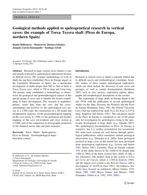
Carbonates Evaporites (2011) 26:29–40<br />
DOI 10.1007/s13146-011-0052-7<br />
ORIGINAL ARTICLE<br />
Geological methods applied to speleogenetical research in vertical<br />
caves: the example of Torca Teyera shaft (Picos <strong>de</strong> Europa,<br />
northern Spain)<br />
Daniel Ballesteros • Montserrat Jiménez-Sánchez •<br />
Joaquín García-Sansegundo • Santiago Giralt<br />
Accepted: 19 February 2011 / Published online: 5 March 2011<br />
Ó Springer-Ver<strong>la</strong>g 2011<br />
Abstract Research in <strong>la</strong>rge vertical caves (shafts) is rare<br />
and usually restricted to speleological explorations because<br />
of difficult access. The systemic methodology of work in<br />
shafts has not been established. Picos <strong>de</strong> Europa massif, in<br />
the Cantabrian Mountains of Spain, has a spectacu<strong>la</strong>r<br />
<strong>de</strong>velopment of shafts <strong>de</strong>eper than 500 m. One of them is<br />
Torca Teyera cave, which is 738 m <strong>de</strong>ep and 4 km long.<br />
The present study established a methodology to characterize<br />
the geological and geomorphological aspects of this<br />
special group of caves and to i<strong>de</strong>ntify the factors contributing<br />
to karst <strong>de</strong>velopment. The research is multidisciplinary,<br />
needs data from the cave and the caves’<br />
surroundings and involves (1) the speleological cave survey<br />
at a 1:500 scale: the construction of a 3D mo<strong>de</strong>l and<br />
morphometric analyses; (2) the geomorphological mapping<br />
on the cave survey at 1:500; (3) the geological and fracture<br />
mapping of the cave environment and cross section at<br />
1:5.000; and (4) the comparison in stereographic projection<br />
of the obtained survey data and joint measures.<br />
Keywords Karst Shafts Speleogenesis<br />
Picos <strong>de</strong> Europa Geomorphological maps<br />
Structural control<br />
D. Ballesteros (&) M. Jiménez-Sánchez<br />
J. García-Sansegundo<br />
Departamento <strong>de</strong> Geología, Universidad <strong>de</strong> Oviedo,<br />
C/Arias <strong>de</strong> Ve<strong>la</strong>sco s/n, 33005 Oviedo, Spain<br />
e-mail: ballesteros@geol.uniovi.es<br />
S. Giralt<br />
<strong>Instituto</strong> <strong>de</strong> <strong>la</strong>s <strong>Ciencias</strong> <strong>de</strong> <strong>la</strong> <strong>Tierra</strong> <strong>Jaume</strong> <strong>Almera</strong> (CSIC),<br />
C/Lluís Solé i Sabarís s/n, 08028 Barcelona, Spain<br />
Introduction<br />
Research in vertical caves or shafts is typically limited due<br />
to difficult access and methodological constraints. Scientific<br />
studies of these require speleological exploration,<br />
which can often inclu<strong>de</strong> the discovery of new caves and<br />
passages, as well as careful documentation (Kambesis<br />
2007) such as cave surveys, exploration reports, photographs<br />
and morphological <strong>de</strong>scriptions of the cavities.<br />
The exploration of <strong>la</strong>rge shafts in Europe began in the<br />
<strong>la</strong>te 1970s with the publication of several speleological<br />
studies on the Alps, Slovenia, the Pyrenees and the Picos<br />
<strong>de</strong> Europa Mountains. Since 1981, the Oxford University<br />
Cave Club has explored the shaft Pozu <strong>de</strong>l H.itu (1,135 m<br />
<strong>de</strong>ep; Singleton and Naylor 1981). The calcareous massif<br />
of the Picos <strong>de</strong> Europa is consi<strong>de</strong>red as one of the prime<br />
sites for investigation by speleologists owing to the spectacu<strong>la</strong>r<br />
<strong>de</strong>velopment of <strong>la</strong>rge shafts (e.g., Ogando 2007).<br />
The speleological documentation in Picos <strong>de</strong> Europa is<br />
extensive, but it is neither systematized nor inventoried.<br />
The main karst systems are well known through speleological<br />
publications, which sometimes inclu<strong>de</strong> geological<br />
observations (e.g., Erhey<strong>de</strong>n et al. 2008). Some geological<br />
research in <strong>la</strong>rge caves of this massif has been <strong>de</strong>veloped<br />
from speleological explorations (e.g., Laverty and Senior<br />
1981; Senior 1987). Currently, Picos <strong>de</strong> Europa contains<br />
13% of the shafts known in the world to be <strong>de</strong>eper than<br />
1,000 m. Most of the karst systems have shafts of only a<br />
few kilometers. The <strong>de</strong>epest shaft in this system is Torca<br />
<strong>de</strong>l Cerro <strong>de</strong>l Cuevón, which is 1,589 m (Estévez 1998),<br />
and the <strong>la</strong>rgest cave system is the Red <strong>de</strong>l Toneyu, with a<br />
<strong>de</strong>velopment of 18,970 m (Gea 1991). Nevertheless, few<br />
works have focused on endokarsts (Hoyos Gómez 1979;<br />
Smart 1984, 1986; Hoyos Gómez and Herrero, 1989;<br />
Fernán<strong>de</strong>z- Gibert et al. 1992, 1994, 2000).<br />
123
30 Carbonates Evaporites (2011) 26:29–40<br />
The present study documents a methodological<br />
approach useful for the geological and geomorphological<br />
characterization of these special environments and discusses<br />
the conditioning of karst <strong>de</strong>velopment.<br />
Setting<br />
Torca Teyera is a <strong>la</strong>rge shaft, 738 m <strong>de</strong>ep, located on<br />
the northern part of the Picos <strong>de</strong> Europa (Fig. 1), a<br />
mountain massif located in the Cantabrian Mountains of<br />
northern Spain. From the structural standpoint, Picos <strong>de</strong><br />
Europa belongs to the Cantabrian Zone of the Varisci<strong>de</strong>s<br />
domain (Lotze 1945; Julivert et al. 1972; Alonso et al.<br />
2009). The bedrock consists mainly of 1,200 m of carboniferous<br />
limestone affected by E–W to NW–SE and<br />
south-directed imbricate variscan system thrust (Fig. 2).<br />
The décollement level of the structures is above silicic<strong>la</strong>stic<br />
rocks from the Pisuerga-Carrión province (Pérez-<br />
Estaún et al. 1988; Marquínez 1989; Farias and Heredia<br />
1994; Bahamon<strong>de</strong> et al. 2007; Merino-Tomé et al. 2009).<br />
During the Alpine orogeny, some of these thrusts were<br />
reactivated, causing the rotation of some thrust sheets<br />
Fig. 1 Situation map of the<br />
Picos <strong>de</strong> Europa massif. The<br />
locations of the cave of study<br />
(Torca Teyera, Fig. 5) are also<br />
shown<br />
123<br />
and leading to the formation of the main relief<br />
(Alonso et al. 1996; Pulgar et al. 1999; Gal<strong>la</strong>stegui<br />
Suárez 2000).<br />
Picos <strong>de</strong> Europa is characterized by a rough and calcareous<br />
relief with peaks exceeding 2,500 m above sea<br />
level (asl) and by the presence of narrow canyons, such as<br />
the Cares Gorge. Canyons up to 2,000-m <strong>de</strong>ep evi<strong>de</strong>nce the<br />
important fluvial incision <strong>de</strong>rived from uplifting. The karst<br />
forms dominate the <strong>la</strong>ndscape (Hoyos Gómez 1979; Smart<br />
1984, 1986; Hoyos Gómez and Herrero 1989; Santos<br />
Alonso and Marquínez García, 2005), although g<strong>la</strong>cial and<br />
perig<strong>la</strong>cial features are preserved (Alonso 1991; González<br />
Suárez and Alonso 1994; Gale and Hoare 1997; Alonso<br />
1998; Jiménez-Sánchez and Farias Arquer 2002; González<br />
Trueba 2006, 2007; Moreno et al. 2009; Serrano Cañadas<br />
and González Trueba 2004). Moreover, nival, gravity and<br />
fluviotorrential processes also control the geomorphological<br />
evolution of the <strong>la</strong>ndscape.<br />
Torca Teyera shaft was discovered, explored and surveyed<br />
by the Groupe Spéléo du Doubs, the Société Suisse<br />
<strong>de</strong> Spéléo-Section <strong>de</strong> Genève, the Société <strong>de</strong>s Amateurs <strong>de</strong>s<br />
Caverns and the Spéléo Club of Nyon between 1979<br />
and 1982 (Borreguero 1986). During these explorations,
Carbonates Evaporites (2011) 26:29–40 31<br />
Fig. 2 Geological map of Picos <strong>de</strong> Europa (after Martínez García and Rodríguez Fernán<strong>de</strong>z 1984; Marquínez 1989; Merino-Tomé et al. 2009).<br />
Location of Torca Teyera (Fig. 5) is shown<br />
Borreguero (1986) prepared the first karst research presenting<br />
the structural control and cave <strong>de</strong>velopment. From<br />
2007 to 2009, 2,700 m of new cave passages were<br />
discovered by the Asociación Deportiva GEMA. At the<br />
present, Torca Teyera has 4 km of known passages<br />
reaching a <strong>de</strong>pth of 738 m.<br />
123
32 Carbonates Evaporites (2011) 26:29–40<br />
Methodology<br />
The present methodology inclu<strong>de</strong>s multidisciplinary<br />
observations to obtain both surficial data and data from the<br />
un<strong>de</strong>rground of the cave. The method is adapted to attain<br />
access to the shaft, which is difficult, and is based on speleological<br />
(Butcher 1950), geomorphological and structural<br />
geology techniques (Alonso et al. 1999; Jiménez-Sánchez<br />
et al. 2004, 2005, 2006). The method inclu<strong>de</strong>s the <strong>de</strong>finition<br />
of an area of 12 km 2 (Figs. 1, 2) including the cave<br />
and its surroundings: (1) the speleological survey at a 1:500<br />
scale; (2) the geomorphological mapping of the cave at a<br />
scale of 1:500 and surrounding of the cavity at a 1:5,000<br />
scale; and (3) the structural study that inclu<strong>de</strong>s the geological<br />
and fracture mapping at a 1:5,000 scale, the cross<br />
section, rose diagram analyses and the <strong>de</strong>finition of the<br />
joints families on stereographic projection.<br />
Cave survey and morphometric analyses<br />
The cave survey that corresponds to the Torca Teyera shaft<br />
is the cave projection in a horizontal p<strong>la</strong>ne. The survey was<br />
mapped using the speleological c<strong>la</strong>ssical method at a 1:500<br />
scale where successive stations were <strong>de</strong>fined in the passages.<br />
Distances, orientation and dip data were measured<br />
between stations using a tape measure or <strong>la</strong>ser, a ruler and a<br />
clinometer, respectively. The cavity survey was ma<strong>de</strong> by<br />
consi<strong>de</strong>ring a reference level between 30 cm and 1.5 m<br />
above the cave floor. The collected data were managed<br />
using the VisualTopo.503 software program (David 2009)<br />
to <strong>de</strong>fine the survey line (a line connecting the stations).<br />
The survey is conducted over the survey line consulting the<br />
sketches ma<strong>de</strong> during the data collection phase. The<br />
VisualTopo.503 software produces a 3D mo<strong>de</strong>l approximating<br />
the passages by an octagonal conduit, the axes of<br />
which are the height and width of the passages.<br />
The morphometric analyses consist of the representation<br />
of the survey data on stereographic projection, a common<br />
structural technique applied to compile figures on the<br />
direction and dip of the cave passages. The orientation and<br />
inclination data are represented on the plot per meter of<br />
surveyed cave. Afterward, a <strong>de</strong>nsity analysis is ma<strong>de</strong> and<br />
the main groups of passages established according to this<br />
direction and dip.<br />
Geomorphological research<br />
The geomorphological research inclu<strong>de</strong>s geomorphological<br />
mapping of both cave and cavity surroundings. Cave geomorphological<br />
mapping was carried out at a 1:500 scale,<br />
taking the cave survey as a topographical basis. Cavity<br />
features were inventoried and c<strong>la</strong>ssified according to<br />
genetic, morphological and sedimentary criteria (Jiménez-<br />
123<br />
Sánchez et al. 2006; Ford and Williams 2007). Sometimes,<br />
the geomorphological mapping and the survey were performed<br />
simultaneously. The limits of the different features<br />
were established and projected on the survey map. Some of<br />
the geomorphological elements located in the cave walls<br />
could not be represented by projecting them on the survey,<br />
since the survey had to be ma<strong>de</strong> at different heights above<br />
the ground. This problem was due to the difficulties in<br />
establishing objectively the boundary between the floor and<br />
the wall of the cave. Therefore, the geomorphological<br />
elements are shown schematically on the outsi<strong>de</strong> contour of<br />
the passages to minimize these problems. These elements<br />
were brought down on the walls along an axis located on<br />
the edge of the passages.<br />
A geomorphologic mapping of the cave surroundings<br />
was charted at a 1,500 scale using field observations and<br />
photo interpretation. This map covers a surface of 12 km 2<br />
and inclu<strong>de</strong>s different <strong>la</strong>ndscape features that are c<strong>la</strong>ssified<br />
according to genetic criteria (Martín-Serrano et al. 2004) in<br />
karstic, g<strong>la</strong>cial, snow, perig<strong>la</strong>cial, gravity and mixed forms.<br />
This map also inclu<strong>de</strong>s the entrances of the caves and the<br />
projection of their passages that have been explored by the<br />
speleologists (Borreguero 1986; Carbajal Rodríguez and<br />
Saiz Barreda 2003); Carbajal et al. 2008; Ballesteros et al.<br />
2009, 2010).<br />
Geological mapping and structural analyses<br />
The geological and fracture maps, covering a combined<br />
total surface of 12 km 2 (Fig. 2), were produced at a<br />
1:5,000 scale by means of field work and photo interpretation.<br />
Three geological cross sections were also prepared.<br />
The cavity study and others were projected over<br />
the maps and over the geological cross sections. Rose<br />
diagram from the data of the fracture map was prepared to<br />
compare with a rose diagram obtained from the orientation<br />
of the cave passages. Furthermore, 157 joint data<br />
measures (dip and direction) were taken on the surface<br />
(124) and in the shaft (33). These data were represented<br />
on stereographic projection and a <strong>de</strong>nsity analysis was<br />
ma<strong>de</strong>. The analysis of <strong>de</strong>nsities allows the establishment<br />
of joint families in which the median p<strong>la</strong>ne is illustrated<br />
in the plot with the bedding. Afterward, the <strong>de</strong>nsity plot of<br />
the orientation and dip of the passages were represented<br />
on the stereographic projection to compare the control of<br />
the joints and the bedding with the direction and inclination<br />
of the passages.<br />
Results and discussion<br />
The application of the methods <strong>de</strong>scribed above obtained<br />
the following results.
Carbonates Evaporites (2011) 26:29–40 33<br />
Cave survey and morphometric analyses<br />
The cave survey and the 3D mo<strong>de</strong>l are shown in Fig. 3.<br />
The cavity consists of three levels of galleries (horizontal<br />
passages) and several pits (vertical passages). The galleries<br />
represent 72% of the <strong>de</strong>velopment of the cave and are<br />
narrow mean<strong>de</strong>rs up to 50 m that join as tributaries and<br />
converge to the NE. Thus, the cavity is a branchwork cave<br />
<strong>de</strong>fined by Palmer (1991). The passages follow the NW–SE<br />
and NE–SW direction in the northern part of the cavity and<br />
the N–S and E–O trend in the southern area.<br />
The groups of passages according to their orientation<br />
and dip were <strong>de</strong>terminate by the representation of the<br />
survey data on stereographic projection. This approximation<br />
is sufficient for passages, but not fully a<strong>de</strong>quate for<br />
shafts because the survey <strong>de</strong>pends on the track of the<br />
speleologists. Therefore, a part of the subvertical measures<br />
does not represent subvertical passages. This fact has been<br />
taken into account for the interpretation of data. Four<br />
groups of passages were established and the median value<br />
of the direction and dip are: (1) subvertical, (2) N10°W/<br />
20°NW, (3) N45°E/20°NE and (4) N125°E/0°.<br />
Cave geomorphological mapping<br />
A selected portion of the geomorphological map of the<br />
southern sector of the shaft is illustrated in Fig. 4. The<br />
legend of the map is divi<strong>de</strong>d into three parts: issues re<strong>la</strong>ted<br />
to (1) the survey, (2) geomorphological features and (3)<br />
geological aspects. The first group inclu<strong>de</strong>s morphometric<br />
data re<strong>la</strong>ted to the passages: contour (using the upper and<br />
lower contour when there is an over<strong>la</strong>p), scarps and pits,<br />
presence of rivers or <strong>la</strong>kes, the slope of the ground and the<br />
value of altitu<strong>de</strong> and <strong>de</strong>pth from the cave entrance at<br />
several points. The position of possible continuations of<br />
Fig. 3 a The cave survey and<br />
b the 3D mo<strong>de</strong>l of Torca<br />
Teyera. The study location<br />
<strong>de</strong>scribed in Fig. 4 is shown<br />
cave passages is also shown. The group of geomorphological<br />
features inclu<strong>de</strong>s (1) speleothems, (2) fluviokarst<br />
and (3) gravity forms. Speleothems are c<strong>la</strong>ssified into<br />
dripstones, flowstones, and mixed and other forms. Dripstone<br />
forms inclu<strong>de</strong> sta<strong>la</strong>gmites, sta<strong>la</strong>ctites and columns.<br />
The flowstones present as casca<strong>de</strong>s and <strong>la</strong>minar forms. The<br />
mixed forms inclu<strong>de</strong> sta<strong>la</strong>gmite masses that originated by<br />
drip and flow of water (Fig. 4a). Other peculiar forms such<br />
as pool <strong>de</strong>posits or col<strong>la</strong>roids forms are noted. The fluviokarst<br />
forms are c<strong>la</strong>ssified as erosive forms or sedimentation<br />
forms. The erosive forms inclu<strong>de</strong> scallops, roof<br />
pendants, corrosion notches, solution runnels, potholes and<br />
relict channels. The erosive forms are mostly located in<br />
active and canyon shaped passages, shafts and at higher<br />
levels, such as relict forms (Fig. 4b). The fluvial <strong>de</strong>posits<br />
are divi<strong>de</strong>d into <strong>de</strong>posits of the active stream channel and<br />
the fluvial terrace (Fig. 4c). These <strong>de</strong>posits have been<br />
c<strong>la</strong>ssified according to the grain size as pebbles, sand and<br />
pebbles, sand, and c<strong>la</strong>y and mud. Finally, the gravity forms<br />
are <strong>de</strong>bris <strong>de</strong>posits, fallen boul<strong>de</strong>rs and single pebbles and<br />
gravel that have been shed by rockfall processes (Varnes<br />
1978). The breakdown <strong>de</strong>posits cover or are covered by<br />
other fluvial and precipitation <strong>de</strong>posits. The geomorphological<br />
map also inclu<strong>de</strong>s other remarkable geological<br />
aspects: quartz, galena and ma<strong>la</strong>chite mineralizations,<br />
altered substrate, structural data and volcanic rocks.<br />
Geomorphological mapping of the cave surrounding<br />
Torca Teyera is located un<strong>de</strong>r a free and half-exposed<br />
karren, dominated by karstic, g<strong>la</strong>cial and nival activity. The<br />
geomorphologic map of the cave surroundings is shown in<br />
Fig. 5a. The distribution of the geomorphological features<br />
is uneven. The <strong>de</strong>posits represent 27.3% of the area of<br />
study and are mainly situated in the valleys. The erosive<br />
123
34 Carbonates Evaporites (2011) 26:29–40<br />
Fig. 4 Details from a selected<br />
portion of the cave<br />
geomorphology map, its legend<br />
and pictures of different<br />
passages. Inset a represents a<br />
gallery shaped like a canyon,<br />
b a sta<strong>la</strong>gmite mass and<br />
c terrace <strong>de</strong>posits formed by<br />
levels of mud and sand<br />
123
Carbonates Evaporites (2011) 26:29–40 35<br />
Fig. 5 a Geomorphological<br />
map, b geological map and<br />
c fracture map of Torca Teyera<br />
area. The shaft is projected on<br />
maps and cross section of<br />
Fig. 6a. The data of the caves<br />
are from Borreguero (1986),<br />
Carbajal Rodríguez and Saiz<br />
Barreda (2003), Carbajal et al.<br />
(2008), Ballesteros et al. (2009,<br />
2010)<br />
forms have been i<strong>de</strong>ntified at the hillsi<strong>de</strong> and the peaks.<br />
The closed <strong>de</strong>pressions occupy 5.0% and are <strong>de</strong>veloped on<br />
slopes up to 40°.<br />
Karstic, snow, g<strong>la</strong>cial, perig<strong>la</strong>cial and gravity forms<br />
were mapped. The former inclu<strong>de</strong>s karstic <strong>de</strong>posits,<br />
dolines, g<strong>la</strong>ciokarst <strong>de</strong>pressions, caves and cave passages<br />
projections. The karst <strong>de</strong>posits are situated in the areas<br />
without slope and are mainly formed by mud that comes<br />
from the dissolution of the limestone. The sinkholes are<br />
<strong>de</strong>pressions of 5- to 20-m wi<strong>de</strong> and 1- to 5-m <strong>de</strong>pth and<br />
associated with gravitational <strong>de</strong>posits. The dolines are<br />
closed and dominated by breakdown processes; thus, they<br />
are mostly col<strong>la</strong>psed sinkholes. The g<strong>la</strong>ciokarst <strong>de</strong>pressions<br />
are closed hollows of 600-m wi<strong>de</strong> and 70-m <strong>de</strong>pth located<br />
123
36 Carbonates Evaporites (2011) 26:29–40<br />
at the valley bottom. The <strong>de</strong>pressions originated from<br />
g<strong>la</strong>cial, karstical and snow activity (Smart 1986; Alonso<br />
1998). The entrances of caves are mainly situated in<br />
sinkholes or g<strong>la</strong>ciokarst <strong>de</strong>pression and represent cave<br />
passages truncated by erosion. Torca Teyera is located<br />
un<strong>de</strong>r a free karren with a lot of closed <strong>de</strong>pressions, gravity<br />
<strong>de</strong>posits and some g<strong>la</strong>cier cirques.<br />
The nivation forms inclu<strong>de</strong> one moraine and some cirques<br />
originated by snow activity. The nivation cirques are<br />
observed in some walls of dolines and in scarps oriented to<br />
the NE or SW. The snow moraine is located un<strong>de</strong>r one<br />
nival cirque. G<strong>la</strong>cial forms cover till <strong>de</strong>posits, horns, arête,<br />
cirques and moraines. A g<strong>la</strong>cial valley is observed in the<br />
NW of Torca Teyera shaft. Till <strong>de</strong>posits, mainly formed by<br />
limestone pebbles and boul<strong>de</strong>rs, sand and mud, are found<br />
in this valley. In some cases, boul<strong>de</strong>rs of limestone in<br />
certain facies are found on the bedrock of limestone with<br />
other facies. The till is often presented in moraines of 1- to<br />
6-m wi<strong>de</strong> and 50- to 60-m long. The horns are <strong>de</strong>gra<strong>de</strong>d<br />
and are situated in the peaks where some arêtes converge.<br />
The cirques are greatly <strong>de</strong>gra<strong>de</strong>d by karstification and their<br />
size is between 100 and 300 m. The only perig<strong>la</strong>cial evi<strong>de</strong>nce<br />
is a rock g<strong>la</strong>cier shown on the eastern part of the<br />
map. The <strong>de</strong>posit is formed by limestone gravels and<br />
boul<strong>de</strong>rs, and presents some transverse and longitudinal<br />
ridges and furrows.<br />
Gravitational forms inclu<strong>de</strong> <strong>de</strong>bris fall, talus <strong>de</strong>posits<br />
and rock ava<strong>la</strong>nches and are situated un<strong>de</strong>r scarps and in<br />
sinkholes. The <strong>de</strong>bris fall generally consists of angu<strong>la</strong>r<br />
pebbles and gravels of limestone. The talus <strong>de</strong>posits are<br />
mostly formed of limestone pebbles and gravel, sand and<br />
mud; these are usually vegetated. The rock ava<strong>la</strong>nches are<br />
formed from disorganization of angu<strong>la</strong>r boul<strong>de</strong>rs and<br />
pebbles of limestone in the NE of the map.<br />
Some geomorphological features (till, closed <strong>de</strong>pressions,<br />
cirques, arêtes, gravity <strong>de</strong>posits and the rock g<strong>la</strong>cier)<br />
are mainly orientated following the NW–SE and NE–SW<br />
directions. This trend represents the orientation of the<br />
bedding, thrusts and the main faults.<br />
Geologic mapping and structural research<br />
The cavity surrounding of the geological map was formed<br />
by both the cave <strong>de</strong>velopment and the tectonics (Fig. 5b).<br />
The surroundings of Torca Teyera were formed by 1,000 m<br />
of limestone of the Val<strong>de</strong>teja and Picos <strong>de</strong> Europa Formations<br />
stacked vertically. The limestone is divi<strong>de</strong>d into<br />
three strata domain as <strong>de</strong>fined by Bahamon<strong>de</strong> et al. (2007):<br />
(1) toe of slope and basin facies, (2) slopes facies and (3)<br />
p<strong>la</strong>tform top facies. The toe of slope and basin facies<br />
inclu<strong>de</strong> well-stratified coarse-grained beds formed by<br />
breccias, bioc<strong>la</strong>stic pack to grainstone limestone, chert and<br />
shales. The slopes facies consist of massive limestone,<br />
123<br />
breccias and boundstone with botryoidal cement fans. The<br />
p<strong>la</strong>tform top facies inclu<strong>de</strong> stratification rocks, mainly<br />
formed by skeletal pack, to grainstone limestone and pink<br />
fossil-rich limestone. Moreover, an an<strong>de</strong>sitic dyke is recognized<br />
in the western middle part of the geological map.<br />
The cavity studied is <strong>de</strong>veloped on limestone affected by<br />
an NW–SE trending, subvertical and SW-directed thrusts<br />
and other faults, the direction of which is SE–NW, SW–NE<br />
or N–S (Figs. 5b, 6a). Two sequences of thrusts have been<br />
recognized based on their geometric re<strong>la</strong>tionships. The first<br />
sequence dips 50–70 NE and is interrupted by an out-ofsequence<br />
anomaly, which dips by 80–90° NE.<br />
Figure 5a shows 2,367 fractures in the study area; these<br />
are represented in a rose diagram (Fig. 6b). The plot shows<br />
three groups of fractures with directions: (1) NE–SW, (2)<br />
N–S and (3) NW–SE. The first group represents 45% of the<br />
total fractures and the second group represents another 17%.<br />
The direction of the cave passages are analyzed by another<br />
rose diagram (Fig. 6c). On comparing both (fracture and<br />
cave direction) rose diagrams, the first structural control of<br />
the orientation can be semiqualitatively established. The<br />
dispersion of values of the shaft orientation is greater than<br />
the fracture data, although the NW–SE direction of the cave<br />
is noted. The group consi<strong>de</strong>red as Fracture 1 is the most<br />
abundant collection, but its influence on the cavity <strong>de</strong>velopment<br />
is less than the group consi<strong>de</strong>red as Fracture 2. This<br />
method does not consi<strong>de</strong>r the influence of the bedding and<br />
the intersection between discontinuities; consequently, it is<br />
only a first approximation to the structural factor.<br />
Seven families of joints have been established on the<br />
stereographic projection. The average p<strong>la</strong>ne of each family<br />
is represented in Fig. 7a. The families J2, J3 and J5 correspond<br />
to the fractures already recognized in a previous<br />
work (Borreguero 1986). The <strong>de</strong>nsity plot of the orientation<br />
and dip of the passages has been shown in gray scale on the<br />
stereographic projection (Fig. 7a) to compare the main<br />
orientations and dips of the joints, the bedding and the cave<br />
passages. Figure 7a highlights that subvertical cave passages<br />
(Group 1 of galleries) are conditioned by the joint<br />
families J1, J3, J4 and J6, as well as their intersections. The<br />
galleries belonging to Group 2 (N10°W/20°N) are mainly<br />
controlled by the intersection between the families J5 and<br />
J6. The passages dipping down 20° to the NE (Group 3)<br />
are ruled by the intersection between family J1, J2, J5 and<br />
J7. The <strong>la</strong>tter group of passages consists of horizontal<br />
galleries in the direction N125°E and follows the bedding<br />
(Fig. 7b).<br />
Conclusions<br />
The use of a multidisciplinary methodology including the<br />
speleological cave survey, geomorphological mapping and
Carbonates Evaporites (2011) 26:29–40 37<br />
Fig. 6 a One of the three cross<br />
sections prepared, the position<br />
of which is shown in Fig. 5b.<br />
b Rose diagram of the fracture<br />
direction and c of the orientation<br />
of Torca Teyera passages<br />
structural techniques is a<strong>de</strong>quate to <strong>de</strong>velop reliable geomorphological<br />
assumptions for a cave with difficult access.<br />
Also, this multidisciplinary methodology allows the <strong>de</strong>finition<br />
of factors controlling karst <strong>de</strong>velopment, especially<br />
the quantitative evaluation of the structural influence on<br />
endokarst.<br />
The speleological cave survey is a graphical document<br />
that is useful to plot geological and geomorphological<br />
information. However, its <strong>de</strong>velopment is complex due to<br />
the adversity of the environment and the subjective criteria<br />
of the researcher who has to inclu<strong>de</strong> different elements<br />
located at inconstant heights above the floor. The 3D mo<strong>de</strong>l<br />
approximates the geometry of the endokarst system as a<br />
whole. In the scale of the passage, the approximation is not<br />
correct because the irregu<strong>la</strong>rities of the passage walls are<br />
not seen. When a section of a gallery or a shaft is not<br />
subcircu<strong>la</strong>r, the mo<strong>de</strong>l does not properly represent the shape<br />
of the passage because the software uses an octagonal<br />
section to approximate the shape of the section. Where the<br />
galleries disp<strong>la</strong>y a canyon morphology, mo<strong>de</strong>ling results are<br />
not accurate because, in the mo<strong>de</strong>l, the value of passage<br />
widths <strong>de</strong>creases with the distance to the floor and the roof.<br />
After mo<strong>de</strong>ling, further analyzing the cave survey data with<br />
stereographic projection is useful to quantitatively c<strong>la</strong>ssify<br />
the cavity passage according to the direction and dip.<br />
Cave geomorphologic mapping indicates the different<br />
forms and their spatial distribution. The map informs about<br />
the genetic processes and their spatial and temporal re<strong>la</strong>tionships.<br />
These aspects are the base of the speleogenetical<br />
mo<strong>de</strong>l of the shaft. Some limitations of the method are<br />
conditioned by the precision of the cave survey. In the wall<br />
of the passages, several interesting forms are present;<br />
nevertheless, these forms cannot be represented on the cave<br />
survey because the plot is only a horizontal projection. If<br />
the forms on the walls are projected over the survey, all of<br />
them are situated in the same p<strong>la</strong>ce. The imprecision of<br />
information on walls can be solved by projecting down the<br />
forms on the cave limits.<br />
123
38 Carbonates Evaporites (2011) 26:29–40<br />
Fig. 7 a Stereographic<br />
projection of the orientation and<br />
dip of the passages showing the<br />
position of the p<strong>la</strong>nes that<br />
represent the main families of<br />
joints and the bedding; b a cave<br />
passage that has been controlled<br />
by the bending; and c the<br />
structural control of each group<br />
of galleries<br />
The geological and fracture mapping of the cave surrounding<br />
and the cross section with the shaft projection<br />
<strong>de</strong>termine the qualitative structural control of the cave. The<br />
comparison between the fracture direction and the orientation<br />
of the cavity passage allows a first hypothesis about<br />
the structural control. This comparison does not consi<strong>de</strong>r<br />
the bending, dip or the hypothetical intersection between<br />
the discontinuities. These limitations can be resolved using<br />
stereographic projection, where the dip and the direction of<br />
joints, bedding and cave passages are represented. This plot<br />
that inclu<strong>de</strong>s survey data together with structural data<br />
evaluates quantitatively the re<strong>la</strong>tionship between the<br />
structure and the endokarst.<br />
Acknowledgments This research has been fun<strong>de</strong>d through the<br />
CONTRACT project (CN-06-177) provi<strong>de</strong>d by ASTURIAS<br />
GOVERNMENT-OVIEDO UNIVERSITY, CALIBRE project<br />
(CAVECAL) (CGL2006-13327-C04/CLI) provi<strong>de</strong>d by Ministerio <strong>de</strong><br />
Educación y Cultura and GRACCIE project (CONSOLIDER<br />
PROGRAM) (CSD2007-00067) provi<strong>de</strong>d by Centro <strong>de</strong> Investigación<br />
Científica y Tecnológica. We acknowledge Dr. Juan Bahamon<strong>de</strong>,<br />
Dr. Óscar Merino, Gemma Sendra, Irene <strong>de</strong> Felipe, Asociación<br />
Deportiva Gema, Grupo Espeleológico Polifemo and GES Montañeiros<br />
Celtas for their help.<br />
References<br />
Alonso V (1991) Geomorfología <strong>de</strong> <strong>la</strong>s cabeceras <strong>de</strong> los ríos Narcea,<br />
Navia y Sil y <strong>de</strong>l Parque Nacional <strong>de</strong> <strong>la</strong> Montaña <strong>de</strong> Covadonga<br />
(NO <strong>de</strong> <strong>la</strong> Penínsu<strong>la</strong> Ibérica). Ph D thesis. Universidad <strong>de</strong><br />
Oviedo. Oviedo. Spain<br />
123<br />
Alonso V (1998) Covadonga National Park (Western Massif of Picos<br />
<strong>de</strong> Europa, NW Spain): a calcareous <strong>de</strong>g<strong>la</strong>ciated area. Trabajos<br />
<strong>de</strong> Geología., vol 20. Universidad <strong>de</strong> Oviedo, pp 167–181. http://<br />
www.geol.uniovi.es/TDG/Volumen20/TG20-06.PDF (Febraury)<br />
2009<br />
Alonso JL, Pulgar JA, García-Ramos JC, Barba P (1996) Tertiary<br />
basins and Alpine tectonics in the Cantabrian Mountain (NW<br />
Spain). In: Friend P, Dabrio C (eds) Tertiary basins of Spain.<br />
Cambridge University Press, Cambridge, pp 19–22<br />
Alonso JL, García-Ramos JC, Gutiérrez-C<strong>la</strong>verol M (1999) Control<br />
estructural <strong>de</strong> <strong>la</strong> cavidad kárstica ‘‘La Cuevona’’ (Riba<strong>de</strong>sel<strong>la</strong>,<br />
Asturias). In: Andreo B, Carrasco F, Duran JJ (eds) Contribución<br />
<strong>de</strong>l estudio científico <strong>de</strong> <strong>la</strong>s cavida<strong>de</strong>s kársticas al conocimiento<br />
geológico. Patronato <strong>de</strong> <strong>la</strong> Cueva <strong>de</strong> Nerja, Nerja, pp 65–76<br />
Alonso JL, Marcos A, Suárez A (2009) Paleogeographic inversion<br />
resulting from <strong>la</strong>rge out of sequence breaching thrusts: The León<br />
Fault (Cantabrian Zone, NW Iberia). A new picture of the<br />
external Variscan Thrust Belt in the Ibero-Armorican Arc.<br />
Geologica Acta 7(4):451–473<br />
Bahamon<strong>de</strong> JR, Merino-Tomé OA, Heredia N (2007) A Pennsylvanian<br />
microbial boundstone-dominated carbonate shelf in a distal<br />
fore<strong>la</strong>nd margin (Picos <strong>de</strong> Europa Province, NW Spain).<br />
Sediment. Geology 198:167–193<br />
Ballesteros D, Caldueño García MA, Cañón Salgado G, Estrada<br />
González S, <strong>de</strong> Felipe Pitcairn J, Fernán<strong>de</strong>z González R,<br />
Fernán<strong>de</strong>z Valencia R, Martínez Muñiz R, Puerta Elorza EA<br />
(2009) Semuñón 2009, Exploración espeleológica en Peña<br />
Jascal, Picos <strong>de</strong> Europa, NO <strong>de</strong> España. Oviedo, Spian.<br />
Unpublished, 41p<br />
Ballesteros D, Puerta Elorza EA, Fernán<strong>de</strong>z Valencia R, <strong>de</strong> Felipe<br />
Pitcairn J (2010) Torca Teyera. Subterránea. Fe<strong>de</strong>ración Españo<strong>la</strong><br />
<strong>de</strong> Espeleología 30:24–26<br />
Borreguero M (1986) Special Picos: Puertos <strong>de</strong> Ondón. Neuchâtel,<br />
Suisse. Unpublished, 118 p<br />
Butcher AL (1950) Cave survey. Publication of the Cave Resarch<br />
group of Great Britain 3, 40 p
Carbonates Evaporites (2011) 26:29–40 39<br />
Carbajal JA, Saiz JR, Ballesteros D (2008) Campaña Espeleológica<br />
Puertos <strong>de</strong> Ondón 2004-2007. Asociación Deportiva GEMA.<br />
Gijón, Spain. Unpublished, 28 p<br />
Carbajal Rodríguez JA, Saiz Barreda JR (2003) Campaña Espeleológica<br />
Puertos <strong>de</strong> Ondón 2003. Asociación Deportiva GEMA.<br />
Gijón, Spain. Unpublished,16 p<br />
David E (2009) Visual Topo. http://vtopo.Free.fr (November 2009)<br />
Durán JJ, Vallejo M, López-Martínez J (2000) Propuesta <strong>de</strong> una<br />
nueva c<strong>la</strong>sificación <strong>de</strong> espeleotemas. V Congreso Geólógico <strong>de</strong><br />
España Sociedad Geológica <strong>de</strong> España. Alicante. Geotemas<br />
1(3):337–340<br />
Erhey<strong>de</strong>n S, Faverjon M, Borchers, N, Charavel R, Cholin A, Sánchez<br />
N, Scipioni M, Gillet R, De<strong>la</strong>bu S (2008) La sima Thesaurus<br />
Fragilis. Exploraciones 2006 y 2007 Vega Huerta, macizo <strong>de</strong><br />
Cornión, Picos <strong>de</strong> Europa. Subterránea, vol 28. Madrid,<br />
pp 34–31. http://www.alexandri.cat/pdf/subterranea/sub28_4sima_<br />
thesaurus.pdf<br />
Estévez JA (1998) 1.589 m Récord <strong>de</strong> España en <strong>la</strong> Torca <strong>de</strong>l Cerro<br />
<strong>de</strong>l Cuevón. Subterránea 10:20–29<br />
Farias P, Heredia N (1994) Geometría y cinemática <strong>de</strong> los dúplex <strong>de</strong><br />
Pambuches (Unidad <strong>de</strong> Picos <strong>de</strong> Europa, Zona Cantábrica, NO<br />
<strong>de</strong> España). Revista Sociedad Geológica <strong>de</strong> España 7(1-2)<br />
113-120. http://www.sociedadgeologica.es/archivos/REV/7(1-2)/<br />
Art08.pdf (October 2009)<br />
Fernán<strong>de</strong>z-Gibert E, Rossi C, Ortiz I (1992) Espeleogénesis y<br />
proce<strong>de</strong>ncia <strong>de</strong> los sedimentos kársticos en el Pozo <strong>de</strong>l L<strong>la</strong>stral<br />
(Unidad Frontal, Macizo <strong>de</strong>l Cornión, Picos <strong>de</strong> Europa). In:<br />
Actas 58 Congreso Español <strong>de</strong> Espeleología. Españo<strong>la</strong> <strong>de</strong><br />
Espeleología, Madrid, Spain, pp 416–425<br />
Fernán<strong>de</strong>z-Gibert E, Palomarès M, Rossi C, Tortosa A (1994)<br />
Análisis <strong>de</strong> proce<strong>de</strong>ncia en arenas kársticas: evi<strong>de</strong>ncia <strong>de</strong> una<br />
cobertera permotriásica erosionada en el macizo occi<strong>de</strong>ntal <strong>de</strong><br />
Picos <strong>de</strong> Europa. In: Fe<strong>de</strong>ración Asturiana <strong>de</strong> Espeleología (ed)<br />
Actas <strong>de</strong>l 1 congreso internacional sobre Picos <strong>de</strong> Europa.<br />
Oviedo, Spain, pp 1–14<br />
Fernán<strong>de</strong>z-Gilbert E, Ca<strong>la</strong>forra JM, Rossi C (2000) Speleogenesis in<br />
the Picos <strong>de</strong> Europa Massif, Northern Spain. In: Limchouk AB,<br />
Ford DC, Palmer AN, Dreybrodt W (eds) Speleogenesis.<br />
Evolution of karst Aquifers. Natl. Speleological Society,<br />
pp 352–357<br />
Ford DC, Williams P W (2007) Karst hydrogeology and geomorphology.<br />
Wiley, Ltd, Chichester, 562p<br />
Gale SJ, Hoare P (1997) The g<strong>la</strong>cial history of the northwest Picos <strong>de</strong><br />
Europa of northern Spain. Z. für Geomorphologie 41:81–96<br />
Gal<strong>la</strong>stegui Suárez J (2000) Estructura cortical <strong>de</strong> <strong>la</strong> cordillera y<br />
margen continental cantábrico: perfiles ESCI-N. Trabajos <strong>de</strong><br />
Geología. vol 22. Universidad <strong>de</strong> Oviedo. pp 9–234. http://www.<br />
geol.uniovi.es/TDG/Volumen22/TG22.PDF (June 2009)<br />
Gea P (1991) Red <strong>de</strong>l Toneyo-Picos <strong>de</strong> Europa Spèlèo Club l’Au<strong>de</strong>.<br />
Unpublished<br />
González Suárez JJ, Alonso V (1994) G<strong>la</strong>ciers in Picos <strong>de</strong> Europa,<br />
Cordillera Cantábrica, northwest Spain. J G<strong>la</strong>ciol 40(134):<br />
198–99<br />
González Trueba JJ (2006) Topoclimatical factors and very small<br />
g<strong>la</strong>ciers in At<strong>la</strong>ntic Mountain of SW Europe: Little Ice Age<br />
g<strong>la</strong>cier advance in Picos <strong>de</strong> Europa (NW Spain). Z für<br />
Gletscherkun<strong>de</strong> und G<strong>la</strong>zialgeologie 39:115–125<br />
González Trueba JJ (2007) El Macizo Central <strong>de</strong> los Picos <strong>de</strong> Europa:<br />
geomorfología y sus implicaciones geoecológicas en <strong>la</strong> alta<br />
montaña cantábrica. Ph D thesis. Universidad <strong>de</strong> Cantabria,<br />
Spain, 819 p. www.tesisenred.net/TDR-0327107-134858<br />
Hoyos Gómez M (1979) El karst en Asturias durante el Pleistoceno<br />
superior y Holoceno. PhD thesis. Universidad Complutense <strong>de</strong><br />
Madrid, Madrid<br />
Hoyos Gómez M, Herrero N (1989) El karst en <strong>la</strong> Cornisa Cantábrica.<br />
In: Duran Valsero JJ, López Martínez L (eds) El Karst en<br />
España. Monografía 4 <strong>de</strong> <strong>la</strong> Sociedad Españo<strong>la</strong> <strong>de</strong> Geomorfología,<br />
pp 109–120<br />
Jiménez-Sánchez M, Farias Arquer P (2002) New radiometric and<br />
geomorphologic evi<strong>de</strong>nces of a <strong>la</strong>st g<strong>la</strong>cial maximum ol<strong>de</strong>r than<br />
18 ka in SW European mountains: the example of Re<strong>de</strong>s Natural<br />
Park (Cantabrian Mountains, NW Spain). Geodinamica Acta<br />
15:93–101<br />
Jiménez-Sánchez M, Anadón Ruiz S, Farias P, García-Sansegundo J,<br />
Canto Toimil N (2004) geomorfología <strong>de</strong> <strong>la</strong> Cueva <strong>de</strong> Tito<br />
Buestillo y <strong>de</strong>l macizo kárstico <strong>de</strong> Ardines (Riba<strong>de</strong>sel<strong>la</strong>, costa<br />
cantábrica, Norte <strong>de</strong> España). Boletín geológico y Minero <strong>de</strong><br />
España 115(2):257–264<br />
Jiménez-Sánchez M, Aranburu A, Martos E, Domínguez-Cuesta MJ<br />
(2005) Geomorphological maps in caves: a research in Cantabrian<br />
Coast, Northern Spain. In: Abstracts volume of the sixth<br />
international conference on geomorphology. International Association<br />
of Geomorphologists. Zaragoza, p 2006<br />
Jiménez-Sánchez M, Aranburu A, Martos E, Domínguez-Cuesta M J<br />
(2006) Cuevas prehistóricas como Patrimonio Geológico en<br />
Asturias: métodos <strong>de</strong> trabajo en <strong>la</strong> cueva <strong>de</strong> Tito Bustillo. In:<br />
Trabajos <strong>de</strong> Geología, vol 26. Universidad <strong>de</strong> Oviedo,:pp<br />
163–174<br />
Julivert M, Fontboté JM, Ribeiro A, Nabais-Con<strong>de</strong> LE (1972) Mapa<br />
tectónico <strong>de</strong> <strong>la</strong> Penínsu<strong>la</strong> Ibérica y Baleares a esca<strong>la</strong> 1:1.000.000.<br />
<strong>Instituto</strong> Geológico y Minero <strong>de</strong> España, Madrid<br />
Kambesis P (2007) The importance of cave exploration to scientific<br />
research. J Cave Karst Stud Natl Speleol Soc 69:46–58<br />
http://www.caves.org/pub/journal/PDF/v69/cave-69-01-46.pdf<br />
(July 2009)<br />
Laverty M, Senior KJ (1981) Geology of the Ario area and cave<br />
<strong>de</strong>velopment in Pozu <strong>de</strong>l Xitu. In: Proceedings of the Oxford<br />
University Cave Club Oxford vol 10, pp 41–50 http://www.<br />
oucc.org.uk/procs/proc10/geology.htm (November 2009)<br />
Lotze F (1945) Zur Glie<strong>de</strong>rung <strong>de</strong>r Variszi<strong>de</strong>n <strong>de</strong>r Iberischen Meseta.<br />
Geotek Forsch 6:78–92<br />
Marquínez J (1989) Mapa geológico <strong>de</strong> <strong>la</strong> Región <strong>de</strong>l Cuera y Picos<br />
<strong>de</strong> Europa (Cordillera Cantábrica, NW <strong>de</strong> España). In: Trabajos<br />
<strong>de</strong> Geología. vol 18. Universidad <strong>de</strong> Oviedo, pp 137–144. http://<br />
www.geol.uniovi.es/TDG/Volumen18/TG18-12.PDF (January<br />
2009)<br />
Martínez García E (1983) El Pérmico <strong>de</strong> <strong>la</strong> Cordillera Cantábrica. In:<br />
Martínez Díaz C (ed) X Congreso Internacional <strong>de</strong> estratigrafíay<br />
geología <strong>de</strong>l Carbonífero. <strong>Instituto</strong> Geológico y Minero <strong>de</strong><br />
España, pp 106–115<br />
Martínez García E, Rodríguez Fernán<strong>de</strong>z LR (1984) Memoria y Mapa<br />
Geológico <strong>de</strong> España a esca<strong>la</strong> 1:50.000 hoja 56 Carreña-<br />
Cabrales. <strong>Instituto</strong> Geológico y Minero <strong>de</strong> España, 45p<br />
Martín-Serrano A, Sa<strong>la</strong>zar A, Nozal F, Suárez A (2004) Mapa<br />
Geomorfológico <strong>de</strong> España a esca<strong>la</strong> 1: 50.000. Guía para su<br />
e<strong>la</strong>boración. <strong>Instituto</strong> Geológico y Minero <strong>de</strong> España, Madrid<br />
Merino-Tomé OA, Bahamon<strong>de</strong> JR, Colmenero JR, Heredia N, Farias<br />
P, Vil<strong>la</strong> E (2009) Emp<strong>la</strong>cement of the Cuera and Picos <strong>de</strong><br />
Europa imbrícate system at the core of Iberian-Armorican arc<br />
(Cantabrian zona, north Spain): New precisions concerning the<br />
timing of the arc clousure. Geol Soc Am 121(5–6):729–751<br />
Miotke F D (1968) Karstmorphologische Studien in <strong>de</strong>r g<strong>la</strong>cial<br />
überformten Höhenstufe <strong>de</strong>r Picos <strong>de</strong> Europa, Nordspanien.<br />
Jahrbuch <strong>de</strong>r Geographischen Gesellschaft zu Hannover. Arbeiten<br />
aus <strong>de</strong>n Geographischen Institut <strong>de</strong>r Technischen Universität<br />
Hannover. Son<strong>de</strong>rheft 4. Selbstver<strong>la</strong>g <strong>de</strong>r Geographischen<br />
Gesellschaft Hannover<br />
Moreno A, Valero-Gracés B L, Jiménez-Sánchez M, Domínguez-<br />
Cuesta MJ, Mata P, Navas A, González-Sampériz P, Stoll H,<br />
Farias P, Morellón M, Corel<strong>la</strong> J P, Rico M (2009) The <strong>la</strong>st<br />
<strong>de</strong>g<strong>la</strong>ciation in the Picos <strong>de</strong> Europa National Park (Cantabrian<br />
Mountains, northern Spain). J Quat Sci. doi:10.1002/jqs.1265<br />
123
40 Carbonates Evaporites (2011) 26:29–40<br />
Ogando E (2007) Picos <strong>de</strong> Europa. Exploraciones Verticales. Boletín<br />
Cántabro <strong>de</strong> Espeleología. Fe<strong>de</strong>ración Cántabra <strong>de</strong> Espeleología<br />
16:43–51<br />
Palmer AN (1991) Origin and morphology of limestone caves. Geol<br />
Soc Am Bull 103:1–21<br />
Pérez-Estaún A, Bastida F, Alonso JL, Marquínez J, Aller J, Álvarez-<br />
Marrón J, Marcos A, Pulgar JA (1988) A thin-skinned tectonics<br />
mo<strong>de</strong>l for an arcuate fold and thrust belt: the Cantabrian Zone<br />
(Variscan Ibero-Armorican Arc). Tectonics 7(3):517–537<br />
Pulgar JA, Alonso JL, Espina RG, Marín JA (1999) La <strong>de</strong>formación<br />
alpina en el basamento varisco <strong>de</strong> <strong>la</strong> Zona Cantábrica. Trabajos<br />
<strong>de</strong> Geología. vol 21. Universidad <strong>de</strong> Oviedo, pp 283–294. http://<br />
www.geol.uniovi.es/TDG/Volumen21/TG21-21.PDF (March 2009)<br />
Santos Alonso R, Marquínez García J (2005) Las formas <strong>de</strong>l <strong>la</strong>piaz en<br />
el sector Norte <strong>de</strong>l Macizo <strong>de</strong>l Cornión, Picos <strong>de</strong> Europa.<br />
Cuaternario y geomorfología Cuaternario y geomorfología 19(1-2):<br />
35–47. http://tierra.rediris.es/CuaternarioyGeomorfologia/images/<br />
vol19_1_2/Cuaternario19(1-2)_03.pdf (September 2009)<br />
Senior KJ (1987) Geology and Speleogenesis of the M2 Cave System,<br />
Western Massif, Picos <strong>de</strong> Europa, Northern Spain. Cave Sci<br />
123<br />
British Cave Res Assoc 14(3):93–103 http://www.picos.yucpc.<br />
org.uk/pdf/cs14n3.pdf (November 2009)<br />
Serrano Cañadas E, González Trueba JJ (2004) Morfodinámica<br />
perig<strong>la</strong>ciar en el grupo Peña Vieja (Macizo Central <strong>de</strong> los Picos<br />
<strong>de</strong> Europa-Cantabria). Cuaternario y geomorfología 18(3-4):<br />
73–88. http://tierra.rediris.es/CuaternarioyGeomorfologia/images/<br />
vol18_3_4/Cuaternario18(3-4)_05.pdf (January 2009)<br />
Singleton J, Naylor G (1981) Pozu <strong>de</strong>l Xitu. Proceedings of the<br />
Oxford University Cave Club, 10<br />
Smart PL (1984) Geology, geomorphology and speleogenesis of the<br />
eastern massif, Picos <strong>de</strong> Europa, Spain. Cave Science. British<br />
Cave Res Assoc 11(4):238–245<br />
Smart PL (1986) Origin and <strong>de</strong>velopment of g<strong>la</strong>cio-karst closed<br />
<strong>de</strong>pressions in the Picos <strong>de</strong> Europa, Spain. Z für Geomorphologie<br />
30:423–443<br />
Varnes DJ (1978) Slope movement types and processes. Landsli<strong>de</strong>s:<br />
analysis and control. Transportation Research Board. Natl Acad<br />
Sci Washington Spec Rep 176:11–33