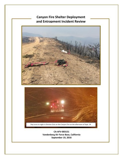
Canyon Fire Shelter Deployment and Entrapment Incident Review
Canyon_Fire_Review
Canyon_Fire_Review

You also want an ePaper? Increase the reach of your titles
YUMPU automatically turns print PDFs into web optimized ePapers that Google loves.
<strong>Canyon</strong> <strong>Fire</strong> <strong>Shelter</strong> <strong>Deployment</strong><br />
<strong>and</strong> <strong>Entrapment</strong> <strong>Incident</strong> <strong>Review</strong><br />
Day turns to night in Division Zulu on the <strong>Canyon</strong> <strong>Fire</strong> on the afternoon of Sept. 19.<br />
CA-AFV-003151<br />
V<strong>and</strong>enberg Air Force Base, California<br />
September 19, 2016<br />
1
From the first time the Division Supervisor directed<br />
resources to head to the safety zone until the sky turned<br />
black <strong>and</strong> the main fire whirl overtook resources was<br />
approximately 4-8 minutes.<br />
* * * *<br />
When asked “How scared were you on a scale of 1 to<br />
10?” multiple crew members replied “9” <strong>and</strong> “10.” Their<br />
escape was approximately 600 to 700 yards.<br />
* * * *<br />
Does it take more “guts” to stop the action, or to<br />
continue what you’re doing even though you have<br />
concerns? How much weight do you give “the worst<br />
case scenario” in your risk assessment?<br />
Excerpts from Section 4 “Considerations, Questions, <strong>and</strong> Discussion Topics”<br />
NWCG Definition of “<strong>Entrapment</strong>”:<br />
A situation where personnel are unexpectedly caught in a fire behavior-related, lifethreatening<br />
position where planned escape routes or safety zones are absent, inadequate, or<br />
compromised. An entrapment may or may not include deployment of a fire shelter for its<br />
intended purpose. These situations may or may not result in injury.<br />
They include "near misses."<br />
Contents<br />
1. Executive Summary…………………………………………………………………………………………. 3<br />
2. Background……………………………………………………………………………………………………… 4<br />
3. <strong>Incident</strong> Narrative……………………………………………………………………………………………. 9<br />
4. Considerations, Questions, <strong>and</strong> Discussion Topics……………………….…………….…….. 17<br />
5. Key Observations <strong>and</strong> Actions………………….……………………….…………………….……….. 24<br />
6. Closing Thoughts…………………………………………….……………………………………………….. 25<br />
7. <strong>Canyon</strong> <strong>Fire</strong> <strong>Shelter</strong> <strong>Deployment</strong> <strong>and</strong> <strong>Entrapment</strong> <strong>Incident</strong> <strong>Review</strong> Team………… 26<br />
8. Appendices<br />
Appendix A – Equipment Report…………………………………………………………….. 27<br />
Appendix B – Map of Safety Zone, Dozer Line Construction,<br />
<strong>and</strong> <strong>Deployment</strong> Sites………..………………………………………...….. 30<br />
Appendix C – <strong>Canyon</strong> <strong>Fire</strong> Weather Summary…………………………………….….. 31<br />
2
1. Executive Summary<br />
The BLM was able to explain that the goal (of this report) was to treat this as<br />
a “lessons learned” opportunity <strong>and</strong> less like a strict <strong>and</strong> formal investigation.<br />
The people involved in this incident were eager to share their video, photos,<br />
<strong>and</strong> their stories so that the rest of the wildl<strong>and</strong> fire community<br />
could learn from what occurred.<br />
At approximately 1730 hours on September 17, 2016, the <strong>Canyon</strong> <strong>Fire</strong> erupted on V<strong>and</strong>enberg Air Force<br />
Base in southern California. With live fuel moisture levels at their lowest of the year, coupled with<br />
drought-stressed vegetation, the fire quickly grew <strong>and</strong> threatened many rocket launch sites, nearby<br />
homes, <strong>and</strong> other critical infrastructure.<br />
By September 18, the fire had grown to 4,528 acres with zero percent containment, prompting the<br />
request for a Type 2 <strong>Incident</strong> Management Team (IMT). The Central Sierra IMT officially took over<br />
management of the <strong>Canyon</strong> <strong>Fire</strong> on Monday, September 19 at 0600.<br />
By 1600 on September 19, the fire had blown up in several areas. This prompted several crews to retreat<br />
to their safety zone. Two firefighters were sent to the hospital with smoke inhalation. It was later<br />
learned that these two firefighters had both dropped their packs <strong>and</strong> removed their fire shelters, with<br />
one of the firefighters actually deploying.<br />
Goal: Make this a Lessons Learned Opportunity<br />
As fire managers were informed of this incident’s severity, notifications were made. After it was learned<br />
that one of the injured firefighters was a Bureau of L<strong>and</strong> Management (BLM) employee, the request was<br />
made by the BLM to conduct a <strong>Shelter</strong> <strong>Deployment</strong> <strong>and</strong> <strong>Entrapment</strong> <strong>Incident</strong> <strong>Review</strong>.<br />
Although led by BLM with this agency’s subject matter expert (SME) support, the U.S. Forest Service was<br />
requested to provide additional support to this follow-up effort. Because it took time for the details of<br />
this event to come to the surface, the team did not officially meet until the evening of September 22—<br />
three days after the event occurred.<br />
Members of the team met with the South Central Sierra IMT <strong>and</strong> cooperators on Friday morning,<br />
September 23, to discuss process <strong>and</strong> what the team hoped to accomplish. There was a great deal of<br />
concern involving the use of the word “Investigation.” However, after meeting with IMT <strong>and</strong> local<br />
cooperator personnel, the BLM was able to explain that the goal was to treat this as a “lessons learned”<br />
opportunity <strong>and</strong> less like a strict <strong>and</strong> formal investigation.<br />
The team’s goal was to meet with the modules <strong>and</strong> individuals assigned that day <strong>and</strong> hear their stories.<br />
It became very clear that had this been a formal <strong>and</strong> “traditional” accident investigation—coupled with<br />
the time that had passed—it would have been almost impossible to get anyone involved to want to talk<br />
about what had happened.<br />
Fortunately, <strong>and</strong> thanks to the explanation of mere semantics, the people involved in this incident were<br />
eager to share their video, photos, <strong>and</strong> their stories so that the rest of the wildl<strong>and</strong> fire community<br />
could learn from what occurred.<br />
3
2. Background<br />
Area History<br />
The history of the surrounding area is provided here to help paint this incident’s overall picture.<br />
The <strong>Canyon</strong> <strong>Fire</strong>’s location has had some level of occupation dating back 7,000 years. During a majority<br />
of this time, the Chumash Indians lived here. Today, there are four known sites that would have had<br />
annual occupation. The Chumash regularly burned these sites, possibly on an annual basis.<br />
There are no historical accounts of a devastating event for this area. The hypothesis is that during the<br />
past three millennia, there have been multiple interruptions in the area’s fuels management.<br />
In the late 1700s, the area was settled by the Spanish missionaries, who remained until 1850 when<br />
California became a part of the United States. Ranching would then become a mainstay in this area until<br />
1941 when Camp Cooke was established as a training camp for the U.S. Army. In 1958, Camp Cooke<br />
became V<strong>and</strong>enberg Air Force Base, which currently serves as this country’s primary launch site for<br />
orbiting satellites.<br />
Topography<br />
The <strong>Canyon</strong> <strong>Fire</strong> footprint is located<br />
within the Santa Ynez Mountain<br />
Range, which runs east to west. The<br />
Tranquillon Ridge, located within<br />
this range, is considered the<br />
backbone of South V<strong>and</strong>enberg.<br />
The southern slopes of the<br />
Tranquillon Ridge are deep <strong>and</strong><br />
narrow. This vertical, steep terrain is<br />
covered in grass from its midway<br />
elevation down to the ocean. This grass component has resulted from grazing <strong>and</strong> fire prescriptions by<br />
ranchers to encourage water shed to the creeks for livestock.<br />
Honda <strong>Canyon</strong>, bordered by Avery Ridge to the north <strong>and</strong> Tranquillon Ridge to the south, is the<br />
centerpiece <strong>and</strong> most significant canyon of South V<strong>and</strong>enberg. This canyon transitions from a deep “U”<br />
shape to a “V” shape as it reaches the ocean. Continuing to the north is a 1,000-foot ridge—locally<br />
known as “Target Ridge”—that Avery Road runs along that curves westward to the Lompoc Hills.<br />
Along the six-mile Honda <strong>Canyon</strong>, these<br />
two steep ridges (Tranquillon <strong>and</strong> Target)<br />
create hundreds of radically inclined ridges<br />
<strong>and</strong> ravines that lead down to the canyon’s<br />
bottom.<br />
The area of operation where the<br />
entrapment incident occurred was an inlet<br />
from the main Honda <strong>Canyon</strong> that formed<br />
a narrow box canyon. This box canyon is<br />
estimated to have a base elevation of 400<br />
feet up to the ridge elevation of 1,050 feet,<br />
4
sloping to the west. The box canyon’s steepness ranges<br />
from 31 to 36 degrees at the inlets to 27 degrees at the<br />
drainage.<br />
From Target Ridge to Tranquillon Ridge is approximately<br />
2.5 miles. The slope from the Tranquillon Ridge to Honda<br />
<strong>Canyon</strong> is estimated at 50 degrees.<br />
Fuels<br />
The main fuel type for this area is chaparral, a fireadapted<br />
vegetation type that is dependent on fire to<br />
stimulate germination. Most chaparral is on a 40 to 60-<br />
year regeneration cycle. Maritime chaparral (as defined<br />
from its geographical location as compared to transition<br />
or interior) is influenced by more summer cloud cover<br />
Maritime Chaparral. Photo courtesy California<br />
Chaparral Institute.<br />
<strong>and</strong> cooler summer temperatures. Maritime chaparral has to respond to a complex set of climatic<br />
factors due to its influence from the Pacific Ocean. In coastal lowl<strong>and</strong>s, the cool <strong>and</strong> moist conditions of<br />
the summer marine layer reduce evaporative dem<strong>and</strong> <strong>and</strong> likely supplement moisture availability that<br />
offsets water deficits due to low annual rainfall.<br />
The maritime influence is complex in central California, involving dimensions of mild temperatures<br />
associated with the summer marine layer, enhanced summer water availability, increased annual rainfall<br />
on coastal upl<strong>and</strong>s, <strong>and</strong> reduced vulnerability to winter freeze events near the coast.<br />
While fire regimes vary among the chaparral zones, maritime chaparral may be favored for moderately<br />
long fire return intervals that have a more intense burn. This evolution has taken place over millions of<br />
years with the natural process being interrupted with the human settlement to the area, as previously<br />
discussed.<br />
Around the early 1900s, when the area came under military occupation, the management of the fuels<br />
would not be done on a broad l<strong>and</strong>scape basis. This would set up the area’s continuous vegetation cover.<br />
Drought History<br />
Honda <strong>Canyon</strong> contains manzanita, chamise, <strong>and</strong> scrub oak. Bear <strong>Canyon</strong> is filled with sagebrush, juniper,<br />
<strong>and</strong> light grasses. The coastal areas here contain non-native st<strong>and</strong>s of Monterey cypress <strong>and</strong> chaparral.<br />
A process known as “salt pruning” is believed to affect the vegetation along the coast. The theory is that<br />
wind <strong>and</strong> fog send salt particles inl<strong>and</strong> <strong>and</strong> prune the chaparral <strong>and</strong> sage on the windward side of the<br />
vegetation, making it look dark <strong>and</strong> diseased.<br />
Due to the December 1977 catastrophic Honda <strong>Canyon</strong> <strong>Fire</strong>—that entrapped <strong>and</strong> killed four people—<strong>and</strong><br />
that year’s subsequent drought ending winter, the fuels here had almost 40 years of uninterrupted<br />
growth.<br />
Since 1977, there have been three recorded droughts: 1992; 2007-2009; <strong>and</strong> the current drought which<br />
started when there was a lower than average rain season during the 2012/2013 season.<br />
The vegetation in Honda <strong>Canyon</strong> was reported as continuous extremely compact brush ranging from 3<br />
to 10 feet in height. While the out leaf color may have suggested a very low fuel moisture during the<br />
<strong>Canyon</strong> <strong>Fire</strong>, the interior was at critical levels—if not completely dead—as growth had been choked out<br />
by other plants. The best description would be an impenetrable shrub that would have been easier to<br />
walk on than through.<br />
5
<strong>Fire</strong> Behavior<br />
Based on the predicted weather generated from a<br />
spot weather forecast on September 18, the second<br />
day of the <strong>Canyon</strong> <strong>Fire</strong>, fire spread models were<br />
developed based on the assumptions of live<br />
herbaceous moisture set at 30 percent <strong>and</strong> the live<br />
woody moisture at 80 percent, the probability of<br />
ignition (POI) was at 100 percent. The expected fire<br />
behavior when wind <strong>and</strong> topography would be in<br />
optimal alignment would have been as follows:<br />
GS2 Fuel Model (moderate load dry climate grassshrub)<br />
Forward rates of spread would be 17-35 feet per<br />
minute—moderate ROS (rate of spread).<br />
Flame lengths 5-8 feet—up to 11 feet during gusts.<br />
Fuel Model 4 (chaparral)<br />
Forward rates of spread 70-114 feet per minute—<br />
dangerous ROS.<br />
Flame lengths 20-24 feet—up to 31 feet during<br />
gusts.<br />
Fuel Model 6 (dormant brush, hardwood slash)<br />
Forward rates of spread 35-53 feet per minute.<br />
Flame lengths 6-8 feet—up to 10 feet during gusts.<br />
Resources Used for This <strong>Review</strong><br />
While developing the inputs for this review, it<br />
became apparent that the fire behavior on the<br />
<strong>Canyon</strong> <strong>Fire</strong> was very similar to fire behavior on<br />
the December 1977 Honda <strong>Canyon</strong> <strong>Fire</strong>, that<br />
entrapped <strong>and</strong> claimed four lives. Several articles<br />
<strong>and</strong> accounts were published on the Honda<br />
<strong>Canyon</strong> <strong>Fire</strong>, including the book Beyond<br />
Tranquillon Ridge by Joseph N. Valencia. This<br />
publication provides a significant amount of<br />
history <strong>and</strong> descriptions of the South V<strong>and</strong>enberg<br />
area. Valencia’s observations <strong>and</strong> accounts<br />
proved to be helpful background material for the<br />
team.<br />
In addition, the historical accounts of the<br />
Chumash Indians was provided during a phone<br />
conversation with a Chumash cultural<br />
representative from the tribe.<br />
Much of the data about the fuels was generated<br />
from an open access article, Ecology <strong>and</strong><br />
Evolution, published by John Wiley & Sons Ltd.<br />
Why the <strong>Canyon</strong> <strong>Fire</strong> Exceeded <strong>Fire</strong> Model Analysis<br />
The actual occurrence, based on reports from crews on the incident as well as video <strong>and</strong> photo<br />
documentation, exceeds the fire model analysis. There are a number of factors to help explain this<br />
occurrence.<br />
First, the effects of a five-year drought have been adversely skewing fire behavior models. The current<br />
burning conditions statewide are proving to be much more volatile than what current models are<br />
predicting. This area is also much more reactive to the subtle changes in the weather, especially a<br />
moderate relative humidity level, where thresholds for a higher burning intensity is approximately 40<br />
percent.<br />
Second, the forecasted weather called for a slope/valley wind to be southwest to west 4-8 mph with<br />
gusts up to 13 mph, <strong>and</strong> ridgetop winds to be west at 6-10 mph with gusts up to 15 mph. The conditions<br />
at the fire site were more of a northerly influence in Honda <strong>Canyon</strong>, with the test burns being pulled<br />
south into the fire, <strong>and</strong> the active fire on the opposing north ridge backing down the canyon. Based on<br />
weather observations, the pattern would not rotate from a northerly influence to a southerly influence<br />
until 1500 on September 19, when it is believed the southern wind took hold.<br />
Third, Honda <strong>Canyon</strong> sets up to create extreme fire behavior based on its steep canyon <strong>and</strong> numerous<br />
ravines <strong>and</strong> box coves within the ridge lines. This canyon topography encourages wind eddies, which<br />
would help developing whirl winds as the air mass moves through the fire-heated area. As this air<br />
preheats the upper-elevation fuels, the fire would be able consume receptive fuels at a higher rate of<br />
spread with high flame lengths.<br />
6
At some point during this timeframe, the fire pushed back up<br />
Tranquillon Ridge, re-burning any fuels that had not previously<br />
been consumed. This event produced a convection column with<br />
enough intensity to create a black-out over the line of operation<br />
that lasted approximately one hour.<br />
<strong>Fire</strong> Behavior in Box <strong>Canyon</strong> Where <strong>Entrapment</strong> <strong>Incident</strong> Occurred<br />
The <strong>Canyon</strong> <strong>Fire</strong>’s behavior, based on photo <strong>and</strong> video evidence, seems to be in line with the higher<br />
limits of modeled fire behavior outputs produced for this review.<br />
Photos taken around 1025 on September 19 show that the fire on Tranquillon Ridge was about 1/3 of<br />
the way down the ridge, backing into the Honda <strong>Canyon</strong> drainage. This line of fire extended across a<br />
majority of the ridge, crawling through the live canopy component <strong>and</strong> the dead under-mix.<br />
On the east side of the box canyon in which the entrapment incident occurred, there are two step<br />
ridges. The fire line on the farthest step (closest to the Honda <strong>Canyon</strong> drainage) looked to be at a slow to<br />
moderate rate of spread with 5 to 8-foot flame lengths, with torching heights looking to be near 15 feet.<br />
The smoke column was well pronounced <strong>and</strong> was developing a convection component.<br />
Increased Levels of <strong>Fire</strong> Behavior<br />
The Firing Boss reports were that the test burn had good consumption with 2 to 3-foot flame lengths<br />
<strong>and</strong> 6-foot flame lengths when heavy pockets of fuel were introduced. There is a video—time stamped<br />
at 1035—of a firing operation being introduced around the safety zone working west that was displaying<br />
increased levels of fire behavior. Flame lengths were overhead with fire whirls pulling fire 20-feet plus.<br />
As this firing operation progressed, the head fire that was being produced was pushing the fire down<br />
canyon 30 feet with 6-foot flame lengths. At approximately 1400, the fire on the second ridge of the<br />
entrapment incident box canyon began to outpace the controlled firing moving west. At approximately<br />
1430, the winds became calm. The column stood up <strong>and</strong> then for 10 to 15 minutes it laid over Avery<br />
Road, on which the resource personnel were operating <strong>and</strong> driving.<br />
This fire event that was happening in the micro environment of the box canyon was most likely<br />
happening on a much gr<strong>and</strong>er scale within Honda <strong>Canyon</strong>. At approximately 1500, a spot was identified<br />
<strong>and</strong> picked up on the north side of Avery Road. <strong>Fire</strong> intensity at this point went to extreme levels.<br />
Strong down-canyon winds were observed in the box canyon, followed by the fire sheeting up the box<br />
canyon’s south face. It is believed that this observed canyon wind was not an isolated phenomenon but<br />
part of the totality of the weather that was affecting Honda <strong>Canyon</strong>. In fact, based on post-fire analysis<br />
of near complete consumption of fuels in both canyons during this 1430-1530 window, the entire<br />
canyon was contributing to the fire production.<br />
Critical Rates of Spread<br />
The fire line that was previously backing down canyon would have been pulled into the drainage with<br />
critical rates of spread with flame impingement sheeting well ahead of the main fire. During this run,<br />
spot fires would have had 100 percent probability of ignition. As such, spot fires quickly burned<br />
together, or, more likely, mass area ignition was occurring.<br />
At some point during this timeframe, the fire pushed back up Tranquillon Ridge, re-burning any fuels<br />
that had not previously been consumed. This event produced a convection column with enough<br />
intensity to create a black-out over the line of operation that lasted approximately one hour.<br />
7
Next, when this column collapsed, the fire quickly re-established a convection column until the fire<br />
progressed out of Honda <strong>Canyon</strong>, moving north into Spring <strong>and</strong> Bear canyons with slightly decreased<br />
intensity.<br />
That night, the overnight temperatures dropped <strong>and</strong> fog rolled inl<strong>and</strong> to the level where resources had<br />
to cease operations due to lack of visibility.<br />
Triggering Factor: Significant Wind<br />
This is the second known occurrence of a fire event in Honda <strong>Canyon</strong> that resulted in extreme fire<br />
behavior that was heavily influenced by the fuels <strong>and</strong> topography. The fuels were in their 40 th year of<br />
growth in the midst of a recorded drought.<br />
These fuels were intermixed with a heavy dead fuel component mixed into the critically dry live<br />
component. The canyon, with its steep ravines <strong>and</strong> multiple ridges that open to the Pacific Ocean,<br />
increases the opportunity for fire whirls <strong>and</strong> major convections to develop—even in the absence of a<br />
significant wind. It is possible that the regeneration cycle was being triggered.<br />
A hypothesis for a triggering factor would be the introduction of a significant wind. The fatal 1977 Honda<br />
<strong>Canyon</strong> <strong>Fire</strong> occurred during a significant southerly wind. This 2016 event occurred during a south wind<br />
that was predicted at a much lower intensity. However, the winds that were reported on September 19<br />
were more in line with the event that transpired in 1977.<br />
8
The <strong>Canyon</strong> <strong>Fire</strong> burning behind the Atlas 5 Rocket Pad on V<strong>and</strong>enberg Air Force Base on Monday, Sept. 18, the day<br />
before the entrapment incident. Photo courtesy Santa Barbara County <strong>Fire</strong> Department.<br />
3. <strong>Incident</strong> Narrative<br />
On September 19 at 0600 the Type 2 Central<br />
Sierra <strong>Incident</strong> Management Team (IMT) took<br />
over the <strong>Canyon</strong> <strong>Fire</strong> on V<strong>and</strong>enberg Air Force<br />
Base.<br />
That morning’s <strong>Canyon</strong> <strong>Fire</strong> operational briefing<br />
had the following resources assigned to Division<br />
Zulu:<br />
One 20-person H<strong>and</strong> Crew consisting of 3<br />
Helitack Crews (who had been told during<br />
the previous operational period of their<br />
assignment);<br />
One local government Strike Team of<br />
Type 3 Engines (S/T 1279) with a Strike<br />
Team Leader (STLD), 3 additional County<br />
Engines (331, 321, 351), a Dozer Strike<br />
Team (9360L), 2 additional County Dozers<br />
(Dozers 1 <strong>and</strong> 2);<br />
One tactical Water Tender (WT 22); <strong>and</strong><br />
One Division Supervisor (DIVS).<br />
VIDEO<br />
Using photos <strong>and</strong> videos from personnel who were working<br />
in Division Zulu, Missoula Smokejumper Mark Pieper, Visual<br />
Information SME, has developed this excellent,<br />
informative video:<br />
https://youtu.be/4yY-cFoIYfM<br />
9
The Initial<br />
Work Assignment<br />
From the night Division<br />
Group Supervisor the<br />
objective was to try <strong>and</strong><br />
keep the fire from getting<br />
North of Avery Road.<br />
Division directions from<br />
the <strong>Incident</strong> Action Plan<br />
(IAP) were to: “Secure the<br />
perimeter on Division Zulu;<br />
Suppress active fire within<br />
Division Zulu; Mop-up 200-<br />
feet in.” In addition,<br />
special instructions were<br />
to: “Be aware of<br />
unexploded ordinances.<br />
Locate, flag area <strong>and</strong> stay<br />
out.”<br />
Saddle Where <strong>Fire</strong><br />
Activity Increased.<br />
<strong>Deployment</strong> Sites.<br />
Looking west from the safety zone at Avery Road running along the top of the ridge.<br />
After the Division Zulu Supervisor took some time to get oriented <strong>and</strong> discussed the viability of “going<br />
direct” it was decided that with the resources on the Division <strong>and</strong> a “long line of fire as far as the eye<br />
could see” there was too much line to be constructed to go direct.<br />
Therefore, the decision was made for the Dozer Strike Team (9360L) to continue line construction down<br />
the ridge <strong>and</strong> that fire would be used to keep the fire “square” as the dozers progressed. The other two<br />
dozers were to stay on the ridge <strong>and</strong> assist in picking up any spot fires. Avery Road is located on a 1,250-<br />
foot ridgetop that prominently runs east-west toward the ocean (see photo above).<br />
Change in Priorities<br />
The Division Supervisor contacted Operations <strong>and</strong> let him know about this new plan. After contact with<br />
Operations, neighboring Divisions were notified that Division Zulu would be putting fire on the ground.<br />
After the approval from Operations, the Division Supervisor briefed Zulu resources of the plan at the<br />
safety zone.<br />
No qualified Firing Boss (FIRB) was identified (as one was not needed because this was not a prescribed<br />
fire). However, an individual from the 20-person Helitack Crew was to run the operation <strong>and</strong> will be<br />
identified as the FIRB(t). Knowing that one of the Engine Captains from the Strike Team was a FIRB(t),<br />
the Strike Team Leader (STLD) asked that Engine Captain 253 be involved in the firing operation solely as<br />
an observer. In addition, a Holding Boss was identified from the Helitack Crew.<br />
Weather Discussion <strong>and</strong> Briefing<br />
The weather for September 19 in the <strong>Incident</strong> Action Plan was developed from a 1632 Sunday<br />
September 18 forecast:<br />
A weak offshore influence has brought a low <strong>and</strong> strong marine inversion to the region that was<br />
currently around 500-feet deep. A very warm <strong>and</strong> dry air mass will continue above this shallow<br />
marine inversion. While there was good humidity recoveries at the lowest elevations of the fire,<br />
the forecast was for poor humidity recoveries to continue above the marine inversion.<br />
10
This September 19 weather briefing further informed:<br />
Onshore winds this afternoon <strong>and</strong> evening will eventually shift to south to southeast. Winds will<br />
also be associated with an influx of increasing mid-level subtropical moisture Monday afternoon<br />
into Monday night.<br />
Ridgetop winds will be south to southeast 5-9 mph with gusts to 12 mph, increasing to 8-14 mph<br />
with gusts to 20 mph in the afternoon. Transport winds are south to southeast 4-8 mph in the<br />
morning, becoming 10-15 mph in the afternoon.<br />
A very slight chance (around 10 percent probability) of thunderstorms with isolated dry lightning<br />
strikes <strong>and</strong> gusty erratic winds across the fire location late Monday afternoon into Monday<br />
night.<br />
The maximum temperature will be 80-85 above the marine layer. The relative humidity will be<br />
20-30 percent.<br />
Keep All Equipment in Safety Zone<br />
Beyond the weather at the Division Supervisor’s briefing, LCES was covered <strong>and</strong> all resources were told<br />
to have all equipment stay in the safety zone unless it was needed to help hold the road. Holders were<br />
to only progress with the firing operation: “Holders needed to be behind the burn.” No questions or<br />
concerns about the operations were raised during this briefing.<br />
Operations<br />
Initially, the intention of the firing<br />
operation was to burn a short piece of<br />
the line from the safety zone about<br />
1,000 feet to the west along Avery Road<br />
to improve the size of the safety zone<br />
<strong>and</strong> widen the line along the ridge <strong>and</strong><br />
keep the fire to the south of Avery Road.<br />
While they were to keep pace with the<br />
forward progress of the fire <strong>and</strong> not let<br />
it get out in front of them <strong>and</strong> cross the<br />
primary line, the firefighting resources<br />
say “there was no real spot to hang the<br />
burn up at.”<br />
A small test burn was conducted around<br />
0945. Once it had been determined that<br />
the test fire was successful, one lighter<br />
began “dot firing” from the safety zone<br />
<strong>and</strong> working west. Discussion with the<br />
dozers pushing down the ridge<br />
estimated that line construction would<br />
be complete in about six hours.<br />
Initially, a FFT1(t) with a qualified FFT1<br />
from the Helitack Crew were assigned as<br />
lookouts. They were to be positioned on top of the ridge to the east to look for spots in the green.<br />
Another Helitack Crew member was taking weather. And there was also a lookout posted at a high point<br />
on top of the ridge to the west.<br />
11
Dozers 1 <strong>and</strong> 2 were to widen the ridgetop road <strong>and</strong> be available to assist picking up any spots if<br />
needed. The remaining resources were to assist with the holding operation—minus one engine off of<br />
S/T 1279 that was working its way east from the safety zone mopping-up.<br />
As the firing operation progressed west, burning conditions were favorable with smoke staying to the<br />
south of the ridge. With these favorable conditions, the firing group wanted to increase the progress of<br />
the burn to the west. The Division Supervisor expressed his concern with this plan because the dozers<br />
were out in the green constructing line, informing: “No, we’re gonna just keep it square.”<br />
Helicopter Support<br />
Around 1400, the Division Zulu Supervisor<br />
requested helicopter support to do some bucket<br />
work to slow fire progression. <strong>Fire</strong> had begun<br />
actively backing. He wanted to prevent this<br />
backing fire from becoming established down<br />
below <strong>and</strong> running back up at resources along the<br />
ridge.<br />
Two helicopters made multiple drops. Once the<br />
fire behavior was moderated, these helicopters left the Division. The firing operation had progressed<br />
approximately 0.25 miles with Strike Team <strong>and</strong> County Engines succeeding along with the burn facing<br />
away from the safety zone. About 30 minutes later, the Dozer Strike Team completed line construction<br />
to the west—three hours ahead of their initial estimate. In addition, the Holding Boss requested that the<br />
lookouts to the east move in front of the firing operation <strong>and</strong> find a better lookout spot.<br />
Engine Captain 331 talked with the Division Supervisor <strong>and</strong> the Helitack Crew Boss<br />
about the 1977 Honda <strong>Canyon</strong> <strong>Fire</strong>. Captain 331 explained that the four entrapment<br />
fatalities on this fire had occurred close to where they were currently working.<br />
The Saddle<br />
The firing operation had advanced approximately 0.34 mile <strong>and</strong> was into the saddle on the ridge <strong>and</strong><br />
keeping pace with the main fire’s progression—adding upward of 200 feet of black below Avery Road by<br />
1400-1415.<br />
Very shortly after, the Engine Captain from E-331, who had gone to validate the work that the Dozer<br />
Strike Team had completed, stopped to talk to the Division Supervisor, showing him their progress on<br />
the map. At this time, the wind began to change. It was now pushing smoke to the north over the ridge<br />
at about 5 mph.<br />
Additionally, Engine Captain 331 talked with the Division Supervisor <strong>and</strong> the Helitack Crew Boss about<br />
the 1977 Honda <strong>Canyon</strong> <strong>Fire</strong>. Captain 331 explained that the four entrapment fatalities on this fire had<br />
occurred close to where they were currently working. With the wind shift blowing embers over the line,<br />
one spot was identified <strong>and</strong> picked up easily. After about 10-15 minutes, conditions returned to being<br />
favorable.<br />
12
“All Division Zulu resources pull back to the safety zone.”<br />
Division Supervisor<br />
Dust Devils<br />
Around 1445-1450, Helitack Crew members noticed two dust devils run across the line from south to<br />
north <strong>and</strong> relayed this to the Holding Boss. The Division Supervisor, who was out in front of the fire,<br />
walked out along a ridge that provided the best vantage point down into Honda <strong>Canyon</strong>. He sees an<br />
“orange glow” but he can’t tell where it’s coming from.<br />
In case they needed to drive out, the Division Supervisor then called Operations <strong>and</strong> asked to have Avery<br />
Road shut down to restrict access coming into the area. He then called the Helitack Crew Boss over to<br />
meet him at his truck to “see what I’m seeing.” The Division Supervisor then called the Dozer Strike<br />
Team to learn their location. He was informed that they were down at Surf Road <strong>and</strong> Cable Road—“in a<br />
good location.”<br />
Once the Helitack Crew Boss arrived at the Division Supervisor’s truck, they walked back out to the<br />
vantage point where the fire had backed 150-200 feet in “maybe in three or four minutes.” The Division<br />
Supervisor <strong>and</strong> the Helitack Crew Boss started jogging back to Division Supervisor’s truck as he radioed<br />
over TAC: “All Division Zulu resources pull back to the safety zone.”<br />
The Helitack Crew Boss had the lighters fire off the remainder of the bowl.<br />
Photo taken from the cab of an engine on Avery Road in Division Zulu.<br />
Day Turns to Night<br />
Shortly after the Division Supervisor made the call for resources to head to the safety zone, the sky<br />
turned from “day to night” almost immediately.<br />
It took a few minutes for the 20-person Helitack Crew, who had divided down into their three “normal”<br />
crews for accountability, to be gathered-up <strong>and</strong> for the engine personnel to load-up <strong>and</strong> to maneuver<br />
their engines to head toward the safety zone.<br />
13
“We couldn’t see five feet in front of us.”<br />
Division Zulu <strong>Fire</strong>fighter<br />
As the fire became established in the bottom of the canyon, the consumption of fuels was audible on the<br />
ridge. Once again, the Division Supervisor repeated himself twice—each time “consecutively louder with<br />
brevity”—for all resources to get to the safety zone.<br />
Progress Moving to the Safety Zone is Slow<br />
With the necessary moving around of vehicles, progression to the safety zone was slow. Captain 253, whose<br />
engine was the farthest engine to the west, began walking east toward the safety zone to make sure the<br />
various resources had heard the Division Supervisor’s transmission to head to the safety zone.<br />
While the remainder of the resources were already heading toward the safety zone, the following personnel in<br />
a vehicle <strong>and</strong> a dozer, located near where the dozer line turned away from Avery Road, headed down the<br />
ridge: the Division Supervisor, one County Dozer, the Helitack Crew Boss, the Firing Boss Trainee, <strong>and</strong> one<br />
other Helitack Crewmember.<br />
The Division Supervisor then made another call for resources to hurry-up <strong>and</strong> get to the safety zone.<br />
The smoke column began to grow <strong>and</strong> blow smoke across the ridge <strong>and</strong> through the saddle, engulfing<br />
resources to the point “that we couldn’t see five feet in front of us.” <strong>Fire</strong>fighters explained how “large charcoal<br />
br<strong>and</strong>s the size of fists were pelting the apparatus.”<br />
Due to this thick smoke <strong>and</strong> poor visibility, even after all the engines had turned around, their progress to the<br />
safety zone was still slow. They could only move forward when they could see the road through the smoke<br />
<strong>and</strong> ensure that they would not run off of the road or over any personnel on foot.<br />
Two County Engines had made it to the safety zone when a Helitack Crewmember hit the side of the last<br />
County Engine (E-331) with his h<strong>and</strong> <strong>and</strong> asked to get inside to seek refuge from the smoke.<br />
“Large charcoal br<strong>and</strong>s the size of fists were pelting the apparatus.”<br />
<strong>Fire</strong> Whirl—Vertical Vortices<br />
As the Division Supervisor progressed into the saddle in his vehicle he saw a fire whirl “60 to 80 feet wide”<br />
start moving. He instructed the Helitack Crew Boss <strong>and</strong> the Firing Boss Trainee to get inside his truck. As<br />
they’re fumbling with their gear he tells them: “Hurry up! I don’t care how you do it, just don’t break the radio<br />
<strong>and</strong> don’t break the window.”<br />
The Division Supervisor told the third Helitack Crewmember to get into the machine with the County Dozer<br />
operator. Next, as the Division Supervisor progressed east toward the safety zone, his truck was hit with a<br />
vertical vortices which “felt like it lifted the truck <strong>and</strong> slammed it down.” Realizing that they would not be able<br />
to make it to the safety zone, he then backed up <strong>and</strong> turned around. Both the County Dozer <strong>and</strong> Division<br />
Supervisor continued to drive short distances back <strong>and</strong> forth along the ridge to avoid ember cast.<br />
Discarded Gear<br />
As the Helitack Crew continued their hike out, they began to hike faster, as one crewmember stated: “The<br />
whirls would blow by giving us a chance to breathe <strong>and</strong> clear our mouth <strong>and</strong> nose of smoke, dust, <strong>and</strong> ash.”<br />
Another crewmember was having an exceptionally difficult time breathing in the smoke. “I felt my body<br />
shutting down. I didn’t care about anything but trying to breath.”<br />
As the smoke became thicker, he could hardly see. He threw off his sunglasses <strong>and</strong> threw his tool <strong>and</strong> made<br />
the decision to pull out his fire shelter. He had difficulty getting his shelter out so he took off his<br />
14
pack <strong>and</strong> knelt down <strong>and</strong><br />
pulled out the fire shelter.<br />
As he finished pulling the<br />
plastic tab from around<br />
the shelter, another<br />
Helitack Crewmember<br />
hiking out passed by him<br />
<strong>and</strong> told him that they<br />
were close to the safety<br />
zone <strong>and</strong> they needed to<br />
go.<br />
The Helitack crewmember<br />
left his gear—but kept the fire shelter—<strong>and</strong> followed the other Helitack Crewmember.<br />
As E-331 progressed toward the safety zone, with the addition of the Helitack Crewmember onboard,<br />
they noticed line gear discarded on the north side of Avery Road that did not belong to this Helitack<br />
Crewmember who they had picked up.<br />
<strong>Shelter</strong> <strong>Deployment</strong><br />
During Engine Captain<br />
253’s progress on foot to<br />
the safety zone he noticed<br />
that the Helitack Crew’s<br />
pace picked up <strong>and</strong> he<br />
wasn’t able to keep up<br />
with them. Within 15-30<br />
seconds of following them,<br />
the plume shifted <strong>and</strong> he<br />
could barely see his feet: “I<br />
couldn’t believe what was<br />
happening.”<br />
As the wind picked up, his<br />
helmet was blown off <strong>and</strong><br />
away. As his pace<br />
increased, he began to<br />
take deeper breaths “just swallowing smoke.”<br />
Every breath <strong>and</strong> every step became more<br />
difficult. Realizing that this was a bad situation<br />
<strong>and</strong> not knowing how far he had to go to the<br />
safety zone, he dropped his tool <strong>and</strong> his gear<br />
<strong>and</strong> grabbed his shelter.<br />
“I knew it was a bad spot to deploy. There was<br />
a lot of green to the north <strong>and</strong> it was on the<br />
road,” the Engine Captain recalls.<br />
As he pulled out his shelter, he says “it felt like<br />
I’d done it a million times.” He pulled the tab,<br />
<strong>Fire</strong>fighter 1’s deployment site.<br />
<strong>Fire</strong>fighter 2’s webgear, tool, <strong>and</strong> equipment.<br />
Area around <strong>Fire</strong>fighter<br />
1’s equipment is flagged<br />
off.<br />
15
“I knew it was a bad spot to deploy. There was a lot of<br />
green to the north <strong>and</strong> it was on the road.”<br />
Engine Captain 253<br />
grabbed the h<strong>and</strong>les, shook it out, stepped inside, <strong>and</strong> got down onto his knees. While he was pulling<br />
the shelter over him, he saw people walking by <strong>and</strong> yelled for help. Two firefighters then assisted Engine<br />
Captain 253 into an engine that was still progressing toward the safety zone.<br />
Arrival at the Safety Zone<br />
Upon arrival at the safety zone, Engine Captain 253 began receiving treatment for smoke inhalation.<br />
Engine 253’s driver had attempted numerous times to contact Captain 253 over the radio during their<br />
egress with no success.<br />
It wasn’t until Engine 253 arrived at the safety zone that contact was made with Captain 253 while he<br />
was receiving treatment in the back seat of Engine 331.<br />
16
4. Considerations, Questions, <strong>and</strong> Discussion Topics –<br />
Regarding Personnel Health, Welfare, <strong>and</strong> Safety<br />
This section provides topics <strong>and</strong> discussion points that were brought to the attention of the team that<br />
pertain to personnel health, welfare, <strong>and</strong> safety.<br />
A. <strong>Fire</strong> Behavior, Column, <strong>and</strong> Smoke<br />
The fire behavior of the main fire on the opposing slope had low to moderate intensity as it<br />
backed toward the drainage with a slow rate of spread (ROS). The firing group easily kept up<br />
with it. The burnout backed downslope toward the main fire with smoke pulling toward the<br />
main fire.<br />
Around 1430, a column formed <strong>and</strong> stood straight up. The column then bent north over the line<br />
<strong>and</strong> started a spot. The column then returned to the south into the drainage toward the main<br />
fire. The sky above you is changing color, from grey to black. Now day has turned into night.<br />
The photo from helibase taken at 1536 shows plume-dominated fire behavior. Resources were<br />
entrapped around 1620. Visibility was poor on Division Zulu <strong>and</strong> resources may have been<br />
unaware of the large column near them or what it was doing.<br />
Just before the sky turned black there were “numerous fire whirls.” Engine 331 stated that the<br />
entire saddle turned into a huge vortices with baseball sized chunks flying around in it.<br />
There is no safety zone in front of you. Your safety zone is back through the black sky. The width<br />
of the line is approximately six dozer blades wide. There are personnel on foot, one dozer <strong>and</strong><br />
seven engines turning around <strong>and</strong> heading back through the black fire whirl to the safety zone.<br />
Discussion Points<br />
Given the benefit of hindsight, we know that the fire behavior on Division Z displayed extreme<br />
rates of spread, flame lengths, <strong>and</strong> consumption. <strong>Fire</strong> behavior training tells us that fire<br />
behavior will generally display indicators that things are changing. What indicators were<br />
present that indicated conditions were changing? How does recognition of changing<br />
conditions get relayed to resources when you notice them on a fire? How can we articulate<br />
concerns we may have when we aren’t the ones in charge?<br />
B. LCES (Lookouts, Communication, Escape route[s], <strong>and</strong> Safety zones)<br />
Lookouts<br />
There was a lookout taking weather observations from a high spot in the safety zone/staging<br />
area. The Holding Boss was in constant communication with the Division Supervisor, holding<br />
forces, <strong>and</strong> the firing group. He was essentially a lookout in the middle of the operation. The<br />
firing group had a trainee managing the firing operation. The Division Supervisor was on the<br />
west end of the operation in a lookout position looking toward the firing group’s progression in<br />
front of holding resources. He had communication with holding <strong>and</strong> firing personnel. There was<br />
another lookout there who was assigned to the Dozer Strike Team constructing line from Avery<br />
Road down the ridge toward the northwest to Surf Road. (See Appendix B for 9/19 planning<br />
map.)<br />
17
Discussion Points<br />
What challenges exist when lookouts cannot see the objective hazards <strong>and</strong> the crews doing<br />
work? Are there potential communication break downs when utilizing multiple short range<br />
lookouts <strong>and</strong> if so what can we do to minimize or eliminate them?<br />
Communication<br />
Line of sight communications on the tactical frequency was adequate. There were instances in<br />
which personnel in the middle of the saddle <strong>and</strong> the personnel at the west end (0.56 miles<br />
away) could not hear each other. Texts were utilized several times during the operation.<br />
Personnel could see each other as they moved from east to west along the ridge.<br />
<strong>Fire</strong> personnel were still on the local frequencies. The NIFC Radio Cache of repeaters had not yet<br />
arrived.<br />
Discussion Points<br />
What do you do when even short-range communication via radio becomes challenging? What<br />
do you do to ensure there are no mix-ups with radio frequencies <strong>and</strong> communications when<br />
fires are transitioning to teams?<br />
Escape Route<br />
The escape plan for resources on Division Z involved all resources traveling east along Avery<br />
Road to the pre-identified safety zone (also the initial briefing <strong>and</strong> staging area). There was a<br />
route down Avery road toward the west but that path took firefighters several miles into the<br />
green. Additionally, the Avery Road to the west was unimproved with several s<strong>and</strong>y areas that<br />
had the potential to get vehicles stuck.<br />
Discussion Points<br />
Training tells us that escape routes: should be the shortest distance to the safety zone, free<br />
from obstructions; we should avoid uphill escape routes when possible <strong>and</strong> that escape times<br />
should be timed. What other considerations should be taken when you are utilizing an escape<br />
route in a vehicle <strong>and</strong> not on foot? Is escaping in a vehicle always faster than escaping on<br />
foot? Why?<br />
Safety Zone(s)<br />
The identified safety zone was approximately 1½ acres before firing operations began. There<br />
was significant black underneath the safety zone to the east, south, <strong>and</strong> ultimately to the<br />
west of the safety zone once firing operations began. The clean black on three sides of the<br />
safety zone made it much larger than the 1½ acres.<br />
The flat dozed-off portion of the safety zone was adequate for staging, although equipment<br />
were bunched-up as they strung out following the firing operation. It was a good place unless<br />
fire crossed the road to the north—then there would be the potential of smoke/fire all along<br />
the north side of Avery Road from the safety zone back to Anguilla Blvd.<br />
After the entrapment <strong>and</strong> shelter deployment, fire was established on the north side of Avery<br />
Road. The decision was made to leave—not because of the fire, but because the area was<br />
heavily impacted by smoke <strong>and</strong> was miserable.<br />
18
Discussion Points<br />
We are taught to estimate safety zone size for what we predict to be the worst case scenario.<br />
In the case of the <strong>Canyon</strong> <strong>Fire</strong> entrapment, worst case involved significant impact of smoke<br />
<strong>and</strong> embers from <strong>and</strong> wind-driven fire run. How do we train firefighters to take into account<br />
the effects of smoke, wind, <strong>and</strong> embers when determining if a safety zone size will be<br />
adequate?<br />
Further Discussion<br />
Discuss the complexities of large incidents with major fire growth during the burn period.<br />
Consider:<br />
Is this situation really as simple as LCES? Put yourself in the firefighters' boots on Division<br />
Zulu. There are many links in the chain between the <strong>Canyon</strong> <strong>Fire</strong> <strong>Incident</strong> Comm<strong>and</strong>er <strong>and</strong><br />
you as a firefighter on the ground. One of these links, the Operations Section Chief, was likely<br />
overwhelmed by large fire growth on multiple divisions of the fire. Another link, Air Attack,<br />
may have been overwhelmed with requests. Finally, the lookout on your division was having<br />
a difficult time—due to smoke <strong>and</strong> terrain—being able to see the larger fire picture.<br />
If you add or remove any link in the chain, the outcome on Division Z may have been<br />
different. Discuss the complexities of a large fire while it's "blowing up" (on an Air Force Base,<br />
with unexploded ordinances, rocket launch sites, <strong>and</strong> extreme terrain) at every level, from IC<br />
to FFT2. Recognize the tendency we all have to convert past situational complexity into<br />
simple, binary decisions.<br />
Is saying LCES was inadequate, therefore they became entrapped, a factual statement? Maybe<br />
so, but delving into the nuances of the situation as a whole leads to many alternative<br />
considerations. What are some of them?<br />
C. Weather <strong>and</strong> <strong>Incident</strong> Meteorologist (IMET)<br />
The weather for September 19 in the <strong>Incident</strong> Action Plan (IAP) was developed from a 1632<br />
Sunday September 18 forecast. The weather discussion was: “A weak offshore influence has<br />
brought a low <strong>and</strong> strong marine inversion to the region (500-feet deep). A very warm <strong>and</strong> dry<br />
air mass will continue above this shallow marine layer. Onshore winds will occur this<br />
afternoon <strong>and</strong> evening, will eventually shift to south/southeast. The maximum temperature<br />
will be 80-85 above the marine layer. The Rh will be 20-30%. Ridgetop winds will be south to<br />
southeast 5-9 mph with gusts to 12 mph, increasing to 8-14 mph with gusts to 20 mph in the<br />
afternoon. Transport winds are south to southeast 4-8 mph in the morning, becoming 10-15<br />
mph in the afternoon.”<br />
The fire was on the south side of Avery Road. The wind was south 2-4 mph <strong>and</strong> downslope.<br />
There was a lookout taking weather observations each hour. The assignment was to squareup<br />
the fire, firing east to west.<br />
An <strong>Incident</strong> Meteorologist (IMET) arrived at the <strong>Incident</strong> Comm<strong>and</strong> Post the morning of<br />
September 19 <strong>and</strong> was directed to prepare weather information for the night operational<br />
period. The IMT took comm<strong>and</strong> of the fire that morning.<br />
19
Discussion Points<br />
There were several firefighters on the <strong>Canyon</strong> <strong>Fire</strong> who had “local knowledge” of the shifty<br />
<strong>and</strong> unpredictable winds in the area. What ideas do you have for making sure that local<br />
knowledge gets passed on to firefighters on the ground making decisions?<br />
D. Trainees<br />
Resources on Division Zulu assigned a Firing Boss Trainee [FIRB(t)] to the firing operation.<br />
They also had an Engine Captain (Captain 253) assigned to watch <strong>and</strong> learn from the firing<br />
operation. There was a Helitack Crewmember who had a FFT1(t) task book assigned as a<br />
weather observer, <strong>and</strong> a lookout stationed on the hill above the safety zone.<br />
Experience vs. Qualified VERSUS Skills vs. Ability<br />
Just because you can, doesn’t always mean you should<br />
We are firefighters. We are doers. We make things happen. It’s why we became firefighters. We<br />
are a “Can Do” group of people.<br />
So when someone asks us to do something, our first reaction is: “When? Where? How far? Let’s<br />
go!” Are we qualified? Do we have that on our Red Card? Am I a trainee? These are all common<br />
questions that run through our minds.<br />
But what happens when we are “qualified” to do a particular task—but, perhaps, haven’t<br />
performed that task very many times? Or, maybe you have, but it’s been a long time or in a<br />
different fuel type?<br />
Self-Reflection <strong>and</strong> Honesty<br />
<strong>Fire</strong> people don’t like to turn down assignments they are otherwise qualified to take. It takes<br />
some serious self-reflection <strong>and</strong> honesty to let that Division Supervisor know that maybe the<br />
assignment isn’t the best fit for you <strong>and</strong> your crew.<br />
It sometimes takes checking your ego to admit that maybe you might be biting-off more than<br />
you can chew. But the good news is there are ways to mitigate <strong>and</strong> really make it a win-win<br />
situation.<br />
For instance, maybe you can shadow for a couple of shifts before taking over the Division? How<br />
about watching that “C” Faller take out that monster snag? Or maybe ask if a couple of your<br />
folks can work with the firing crew to get an idea of how the fuels are burning?<br />
Just because you can, doesn’t always mean you should. Really being honest about the skills you<br />
<strong>and</strong> your crew bring to the fire takes confidence <strong>and</strong> professionalism.<br />
E. Medical Response <strong>and</strong> Extraction<br />
Engine 331 picked up a firefighter when he used his h<strong>and</strong> to smack the side window behind the<br />
driver. A few minutes later, a second firefighter was seen st<strong>and</strong>ing up with a fire shelter on his<br />
back. “If he hadn’t been st<strong>and</strong>ing up, we would have driven right past him,” said Engine 331<br />
personnel.<br />
Both of these firefighters were driven out to the safety zone. Engine personnel called <strong>and</strong><br />
requested an ambulance for smoke inhalation to transport personnel to the hospital. But due to<br />
the fire behavior, the ambulance could not get to the rendezvous point. Instead, personnel were<br />
20
transported in an engine to the V<strong>and</strong>enberg Training Center where they were transferred to an<br />
ambulance. An EMT-P rode in the ambulance with the affected personnel to the hospital.<br />
F. Personnel Accountability<br />
From the first time the Division Supervisor directed resources to head to the safety zone until<br />
the sky turned black <strong>and</strong> the main fire whirl overtook resources was approximately 4-8 minutes.<br />
He directed them two additional times within that timeframe to leave. Seven engines, one<br />
dozer, all of the ground personnel, <strong>and</strong> two pickup trucks all had to hear this order, recognize<br />
the situation, <strong>and</strong> travel back to the safety zone.<br />
The Division Supervisor plus two proceeded west in the Division Supervisor’s truck, along with<br />
one firefighter who rode in the dozer. Two firefighters on foot were picked up by an engine<br />
while the rest of the ground resources hiked to the safety zone.<br />
Engine 253 personnel were looking for their Captain who they eventually found at the safety<br />
zone. The mix of Helitack Crews moved out individually. Everyone was accounted for when they<br />
got to the safety zone, with the exception of the three crewmembers who escaped to the west.<br />
There was no communication back to Division personnel.<br />
G. Resources, Equipment, <strong>and</strong> the Assignment<br />
The following resources were assigned to Division Zulu at the 0600 morning operational briefing:<br />
One 20-person H<strong>and</strong> Crew consisting of three different Helitack Modules; Strike Team 1279 (5<br />
engines); County Engines 321, 331, 351; Dozer Strike Team 9360L; County Dozers 1 <strong>and</strong> 2;<br />
Tactical Water Tender WT-22; 1 Strike Team Leader; <strong>and</strong> the Division Supervisor.<br />
The work assignment was to: “Secure the perimeter on Div. Z; Suppress active fire within Div. Z;<br />
Mop-up 200 feet in.” The special instructions were to: “Be aware of unexploded ordinance.<br />
Locate, flag area <strong>and</strong> stay out.” There was a Helicopter Coordinator (HELCO) <strong>and</strong> two Type 2<br />
Helicopters assigned for support. A safety/tactical briefing was conducted at the safety<br />
zone/staging area prior to the firing operation. The objective was to square-up fire going from<br />
east to west <strong>and</strong> hold the line.<br />
Most of the day (Sept. 19), fire behavior was characterized with a low rate of spread—until, very<br />
rapidly, the fire started to outpace the firing operation <strong>and</strong> holding.<br />
A decision was made to fire ahead of the fire so it would not come to the line <strong>and</strong> out-flank<br />
them.<br />
H. <strong>Incident</strong> Management Team Notification<br />
This was the first operational period for the Type 2 <strong>Incident</strong> Management Team (IMT) <strong>and</strong> the<br />
incident was still on the local radio system. The IMT was notified that resources had to move<br />
back to a safety zone. They were also notified that two personnel needed an ambulance for<br />
smoke inhalation. Their <strong>Incident</strong> Within <strong>and</strong> <strong>Incident</strong> (IWI) process was initiated for this medical<br />
incident. However, it was several hours later (3+) before the <strong>Incident</strong> Comm<strong>and</strong>er (IC) <strong>and</strong><br />
Deputy IC were notified that there was a shelter deployment. The IMT did start Regional<br />
notification regarding the shelter deployment.<br />
21
Further Discussion<br />
A. Escape<br />
The escape was described by one of the Helitack crewmembers as “running on<br />
the razor’s edge.” When asked: “How scared were you on a scale of 1 to 10?”<br />
multiple crew members replied “9” <strong>and</strong> “10.” Their escape was approximately<br />
600 to 700 yards.<br />
Discussion Points<br />
What’s the difference between being scared <strong>and</strong> getting burned up?<br />
Luck. You are scared for very good reasons.<br />
Dropping gear <strong>and</strong> tools speed escape. <strong>Review</strong> <strong>and</strong> discuss the article on<br />
page 6 of The Wildl<strong>and</strong> <strong>Fire</strong>fighter Health <strong>and</strong> Safety Report:<br />
http://www.fs.fed.us/td/pubs/pdfpubs/pdf00512855/pdf00512855dpi72.pdf<br />
Dropping gear <strong>and</strong> tools is also discussed on page 4 of The New<br />
Generation <strong>Fire</strong> <strong>Shelter</strong> training booklet:<br />
http://www.nwcg.gov/sites/default/files/products/newshelt72.pdf<br />
Dropping a pack can be a difficult decision. Judging from not only this<br />
entrapment, but others in the past, it is rarely done.<br />
Screen grab from a firefighter’s<br />
video of a Helitack Module<br />
Crewmember running during<br />
the Division Zulu personnel’s<br />
escape to safety.<br />
• If you are anywhere close to a “9” or “10” on your “scared<br />
scale,” drop your pack, grab your shelter, <strong>and</strong> run. Contents of a pack are just “stuff.”<br />
Everything can be replaced. Your successful escape is paramount.<br />
The helitack personnel ran through heavy smoke <strong>and</strong> were mostly “9’s” <strong>and</strong> “10” out of “10” on<br />
the “panic meter.” There were seven large engines near them that also drove through heavy<br />
smoke. Take a step back <strong>and</strong> think about running versus riding in a vehicle in a situation like this.<br />
Do vehicles give firefighters a false sense of security? Take another step back <strong>and</strong> think about<br />
what could have happened driving a huge truck on a knife ridge with almost no visibility. Add to<br />
this the people on foot—near you—who are trying to escape, <strong>and</strong> you may realize this situation<br />
could have been much worse. Discuss the moment when it seems like you have no choice but to<br />
run or drive fast. Try to feel what it’s like to be in a panic <strong>and</strong> recognize how hard it is to make<br />
sound decisions. An overriding theme in shelter deployments is how fast they can happen. How<br />
can you prepare yourself for this moment?<br />
B. Safety Zone<br />
Before the burnout along the ridge, the area was dozed <strong>and</strong> the south <strong>and</strong> west (fire) sides of the safety<br />
zone was burned. Even though the dozed area was relatively small, including the burnout, the total size<br />
was very large—many acres.<br />
After escaping to the designated safety zone, some firefighters discussed the possibility of needing to<br />
deploy fire shelters. <strong>Fire</strong> started coming back toward the safety zone from the north (green) side, while<br />
smoke, heat, <strong>and</strong> embers were still coming into the safety zone from the west.<br />
Discussion Points<br />
Even with safety zone guidelines (old or new), the true effectiveness of a designated safety zone<br />
is not known until the fire proves it.<br />
22
If you believe fire shelters may be needed—keep your options open <strong>and</strong> be ready.<br />
C. Trigger Points<br />
Trigger points on Division Z were set <strong>and</strong> used. They were, however, set incorrectly. Resources on the<br />
Division were entrapped. Is this statement hindsight biased? Yes, it is. But, to expect firefighters to set<br />
trigger points perfectly every time is foolish. Just like safety zones, the true effectiveness of trigger<br />
points is unknown until the fire proves it.<br />
Discussion Points<br />
Do trigger points give firefighters a false sense of security? How do you know if your trigger<br />
points are correct?<br />
Can we set trigger points so that disengagement happens closer to the “first hint” instead of the<br />
“last fact”?<br />
Does it take more “guts” to stop the action, or to continue what you’re doing even though you<br />
have concerns?<br />
How much weight do you give “the worst case scenario” in your risk assessment?<br />
D. “Keeping Calm” versus “Keeping It Real”<br />
When the Division Supervisor picked up Helitack Module Crewmembers in his truck, he stated: “If this<br />
line of engines doesn’t get moving, we’re going to get burned over.” Meanwhile, with hot embers<br />
blowing over one of the engines, that driver states: “We’re OK.”<br />
Discussion Points<br />
Does trying to keep people calm give a false sense of security?<br />
Does trying to share reality expedite panic?<br />
E. Smoke Column<br />
The smoke column can tell you a lot about what your fire is doing <strong>and</strong> what it will likely do.<br />
Discussion Points<br />
Are you in contact with anyone who has the “big picture” of your column?<br />
Can you see what your column is doing if you are under it?<br />
• If you are under the column, is it time to disengage?<br />
23
5. Key Observations <strong>and</strong> Actions<br />
A. Observation: Escape Routes <strong>and</strong> Escape Times for Vehicles/Engine Modules<br />
There is an emphasis with h<strong>and</strong> crews to timing an escape route <strong>and</strong> making sure that escape times are<br />
known. If escape times become too long or the fire behavior conditions change, then: something has to<br />
be adjusted; identify new <strong>and</strong> closer safety zones; initiate a less aggressive level of engagement; or<br />
watch the fire until escape times will ensure a positive safety margin.<br />
But, do we take the same approach when we are driving in a vehicle? Is it a common practice for an<br />
engine holding behind a firing operation to time their escape route? Is the time it takes to turn a Strike<br />
Team of engines around factored into escape time?<br />
Know the escape time is necessary when developing valid trigger points. If your known escape time is<br />
long, then trigger points are adjusted <strong>and</strong> the decision to disengage will be made much sooner.<br />
ACTION<br />
<strong>Review</strong> the “<strong>Entrapment</strong> Avoidance, It’s Your Call” (Wildl<strong>and</strong> <strong>Fire</strong> Safety Office, U.S. Forest Service,<br />
March 2002) training package with your module. Discuss: the concepts of levels of engagement, positive<br />
safety margin, escape time, valid escape routes <strong>and</strong> valid safety zones.<br />
How do these concepts apply to your specific piece of equipment or module? How can you incorporate<br />
them into your daily firefighting <strong>and</strong> decision making?<br />
B. Observation: <strong>Entrapment</strong> Avoidance Concepts<br />
By all accounts, the decision to fire the dozer line was not made hastily. Alternatives were considered,<br />
line was scouted, <strong>and</strong> a plan was developed. Adequate holding resources were available.<br />
The firing operation was started from a safety zone, was anchored to black, <strong>and</strong> was working down the<br />
ridge (from high to low). In addition, wind conditions at the time were favorable.<br />
The firefighters in Division Zulu were positioned on the flank of the fire. When the wind shifted, the<br />
firefighters on this day had very little time to seek refuge in a safety zone.<br />
In the article “The Dead-Man Zone: A Neglected Area of <strong>Fire</strong>fighter Safety” (by Phil Cheney, Jim Gould,<br />
<strong>and</strong> Lachie McCaw), the authors write:<br />
“<strong>Fire</strong>fighters engaged in parallel or indirect attack are working in a ‘dead-man zone’ if they do not<br />
appreciate the time <strong>and</strong> space required to find a safe refuge. In this zone, if the wind direction changes,<br />
the fire can advance so rapidly that the firefighters have very little time to seek refuge in the burnt area<br />
behind a suppressed portion of line, or egress elsewhere, before the fire overwhelms them.”<br />
ACTION<br />
Read the “The Dead-Man Zone” article referenced above <strong>and</strong> watch the short video of the same name:<br />
https://www.youtube.com/watch?v=uMGuiv2SYeg. Are there similarities between the incident<br />
described in this report <strong>and</strong> the concepts described in the video? What mitigations can be made if you<br />
find yourself working in a similar situation? How will you apply the entrapment avoidance concepts in a<br />
similar situation?<br />
24
6. Closing Thoughts<br />
Never Forget – Always Remember<br />
Whenever we have a tragic loss of life or a serious event in the fire service, we often hear “Never<br />
Forget” or “Always Remember.”<br />
But how many times have you fought fire on a piece of dirt where something tragic happened <strong>and</strong> yet<br />
you never knew about it?<br />
Once you have your resource order in h<strong>and</strong>, do you pull up the weather or take a look at the pocket card<br />
for where you’re going?<br />
When you get to your assignment do you talk to the locals to get a feel for local weather factors or learn<br />
if there are any tragedy fires that have occurred in the area?<br />
By always being a student of fire history <strong>and</strong> remaining curious, we can do our part to “never forget <strong>and</strong><br />
always remember” <strong>and</strong> ensure that we honor those who have lost their lives.<br />
The four men who perished on the December 1977 Honda <strong>Canyon</strong> <strong>Fire</strong> (from left):<br />
Colonel Joseph Turner, <strong>Fire</strong> Chief Billy Bell, Assistant Chief Gene Cooper, <strong>and</strong> Dozer<br />
Operator Clarence McCauley.<br />
In December 1977 on the Honda <strong>Canyon</strong> <strong>Fire</strong>, four people were fatality overrun by fire. This tragedy<br />
occurred on the same ridge just 1.4 miles west of the Division Zulu safety zone on the <strong>Canyon</strong> <strong>Fire</strong>.<br />
Three men perished when the <strong>Fire</strong> Comm<strong>and</strong>er’s vehicle was overrun by fire: Colonel Joseph Turner,<br />
<strong>Fire</strong> Chief Billy Bell, <strong>and</strong> Assistant Chief Gene Cooper. Two weeks after being burned over <strong>and</strong><br />
hospitalized, Dozer Operator Clarence McCauley died of his burn injuries.<br />
25
7. <strong>Canyon</strong> <strong>Fire</strong> <strong>Shelter</strong> <strong>Deployment</strong> <strong>and</strong> <strong>Entrapment</strong> <strong>Incident</strong> <strong>Review</strong><br />
Team Members<br />
Glenn “Kipp” Morrill, Team Lead<br />
BLM California State Aviation Manager/State <strong>Fire</strong> Safety Lead<br />
California State Office<br />
Sacramento, California<br />
Pete Duncan, Facilitated Learning Analysis Coach<br />
<strong>Fire</strong> Operations Risk Management Officer<br />
Forest Service Pacific Southwest Region<br />
Vallejo, California<br />
Tom Johnston, Safety SME<br />
Washington Office<br />
National <strong>Incident</strong> Management Organization<br />
Boise, Idaho<br />
Lief Mathiesen, SME<br />
Superintendent, Kern Valley Interagency Hotshot Crew<br />
BLM Bakersfield Field Office<br />
Bakersfield, California<br />
Tony Petrilli, SME<br />
Equipment Specialist<br />
Missoula Technology Development Center<br />
Missoula, Montana<br />
Mark Pieper, Visual Information SME<br />
Missoula Smokejumpers<br />
Missoula, Montana<br />
Scott Jones, <strong>Fire</strong> Behavior Analyst<br />
Cal <strong>Fire</strong> Battalion Chief<br />
Butte Unit<br />
Chico, California<br />
Sara Billings, Writer-Editor/SME<br />
District Assistant <strong>Fire</strong> Management Officer-Fuels<br />
Plumas National Forest<br />
Blairsden, California<br />
26
8. Appendices<br />
Appendix A – Equipment Report<br />
<br />
<br />
<br />
<strong>Entrapment</strong>/<strong>Shelter</strong> <strong>Deployment</strong> Site<br />
Latitude x Longitude: 34°36'42.81"N x 120°35'55.66"W<br />
Elevation: 1,025 feet.<br />
Description: The deployment sites were directly adjacent to Avery Road, 388 <strong>and</strong> 524 feet from<br />
the safety zone. The dozer widened the road to use it as control line. The majority of the south<br />
side of the road was black from the earlier burning operation. The north side of the road was<br />
considered green with 2 to 10-foot tall brush <strong>and</strong> small trees. Because the fire spread direction<br />
was to the north, the site received mostly radiant heat. Locations of all equipment was marked<br />
by flagging.<br />
Engine Captain 253<br />
<strong>Fire</strong> <strong>Shelter</strong>: Manufacture Date – February 2014.<br />
o After the shelter was left at the deployment site, it was reported that the shelter was<br />
being tossed around by the wind. Dozer 2 was able to hold the shelter in place with its<br />
blade.<br />
o Structural Condition: A few spots of extreme heat are present. The spots were likely<br />
caused by hot embers.<br />
PVC Bag: The bag was found at the shelter deployment site, it was mostly melted.<br />
<strong>Fire</strong>line Pack: Padding cover melted.<br />
27
Escape – When directed to go back to the safety zone, Captain 253 wanted to ensure that all engines got<br />
the word. He stopped at every engine he came to <strong>and</strong> told them to turn around <strong>and</strong> get back to the<br />
safety zone. Smoke <strong>and</strong> embers hit him hard. He attempted to keep pace with the Helitack Crew. It felt<br />
like the whole smoke plume came down on him. The smoke was so thick, he couldn’t see his feet. The<br />
wind blew his helmet off. Keeping up with the Helitack Crew was unsuccessful.<br />
Decision to Deploy – It was hot <strong>and</strong> very smoky. He couldn’t see. He couldn’t breathe. His legs quit<br />
moving. He felt he had to use his last option: His fire shelter.<br />
Deploying <strong>Shelter</strong> – He dropped his pack <strong>and</strong> removed his fire shelter. He knew exactly what to do, he’d<br />
done it many times in training. He shook it out. It felt stiff compared to the practice shelter.<br />
He selected the dozed area between two areas where he didn’t want to be—the green <strong>and</strong> the road. He<br />
turned his back to the wind, put his feet into the shelter <strong>and</strong> began to lie down.<br />
As he was crawling into his shelter, he saw boots <strong>and</strong> yelled for help. Two Helitack Crewmembers picked<br />
him up. As an engine drove by, they pounded on the door, opened it, <strong>and</strong> pushed him into the cab.<br />
<br />
Helitack Crewmember<br />
<strong>Fire</strong> <strong>Shelter</strong>: The fire shelter was carried by the firefighter to the safety zone. It was mostly<br />
accordion folded.<br />
28
PVC Bag: The bag was found at the pack drop site, it was mostly melted.<br />
<strong>Fire</strong>line Pack: Numerous melt spots were present on the pack, most likely caused by hot ember<br />
contact during the entrapment.<br />
Escape – The Helitack Crewmember began to move quickly as soon as they were told to get back to the<br />
safety zone. At first, the blowing smoke <strong>and</strong> embers would come <strong>and</strong> go. It was possible to get a good<br />
solid breath of fresh air every so often. Soon the pockets of good air stopped returning. He felt he<br />
couldn’t see, so he tossed his sunglasses.<br />
Decision to Deploy – More heat, smoke <strong>and</strong> embers came. All he could see was black <strong>and</strong> orange. He<br />
felt he was suffocating <strong>and</strong> couldn’t continue to the safety zone. He tossed his tool, dropped his pack<br />
<strong>and</strong> grabbed his shelter. He didn’t care about his water bottles or radio.<br />
He selected the dozed area between the green <strong>and</strong> the road to deploy his shelter. He tore open the<br />
shelter’s PVC bag <strong>and</strong> grabbed the shelter, ready to deploy. Right then he saw another Helitack<br />
Crewmember hike by. With encouragement, the Helitack Crewmember once again began to run, this<br />
time with only his shelter. They then came upon Engine Captain 253 deploying his shelter <strong>and</strong> stopped<br />
to assist him with getting into an engine.<br />
29
Appendix B<br />
Map of Safety Zone, Dozer Line Construction, <strong>and</strong> <strong>Deployment</strong> Sites<br />
30
Appendix C<br />
31
32
33