Marc €- Setchko - Lane County Government
Marc €- Setchko - Lane County Government
Marc €- Setchko - Lane County Government
Create successful ePaper yourself
Turn your PDF publications into a flip-book with our unique Google optimized e-Paper software.
Jul 08 10 06:21~ Jim Just 541-258-6810 p.2<br />
<strong>Marc</strong> <strong>€</strong>- <strong>Setchko</strong><br />
CONSULTING FORESTER<br />
+ 870 Fox Glenn Avenue<br />
8&%~4kQ Eugene, Oregon 97405<br />
d+Yb- Phone: (541) 344-0473<br />
CP<br />
FAX: (541) 344-779 1<br />
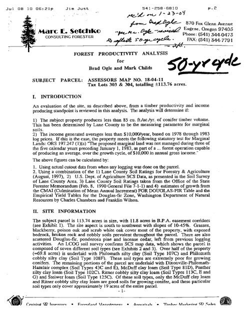
FOREST PRODUCTIVITY ANALYSIS . I<br />
for<br />
Brad Ogle and Mark Childs 5g-Y<br />
SUBJECT PARCEL: ASSESSORS MAP NO. 18-04-11<br />
Tax Lots 303 & 304, totalling k113.76 acres.<br />
I. INTRODUCTION<br />
An evaluation of the site. as described above, from a timber productivity and income<br />
producing standpoint is reviewed in this analysis. The analysis will determine if:<br />
1) The subject property produces less than 85 cu. ft./aclyr. of conifer timber volume.<br />
This has been determined by <strong>Lane</strong> <strong>County</strong> to be the measuring parameter for marginal<br />
soils.<br />
2) The income generated averases less than $lO,OOO/year, based on 1978 through 1983<br />
log prices. If this is the case, the property meets the following statutory test for Marginal<br />
Lands: ORS 197.247 (l)(a) "The proposed marginal land was not managed during three of<br />
the five calendar years preceding January 1, 1983, as part of a ... forest operation capable<br />
of producing an average. over the growth cycle, of $10,000 in annual gross income."<br />
The above figures can be calculated by:<br />
1. Using actual cutout data from when any logging was done on the parcel.<br />
2. Using a combination of the 1) <strong>Lane</strong> <strong>County</strong> Soil Ratings for Forestry & Agriculture<br />
(August, 1997), 2) U.S. Dept. of Agriculture SCS Data, as presented in the Soil Survey<br />
of <strong>Lane</strong> <strong>County</strong> Area. 3) <strong>Lane</strong> <strong>County</strong> Soil Ratings taken from the Office of the State<br />
Forester Memorandum (Feb. 8, 1990 General File 7-1-1) and 4) estimates of growth from<br />
the CMAI (CuIrnination of Mean Annual Increment) FOR DOUGLAS-FIR TabIe and the<br />
Empirical Yield Tables for the Douglas-fir Zone, Washington Department of Natural<br />
Resources by Charles Chambers and Franklin Wilson.<br />
It. SITE INFORMATION<br />
The subject parcel is 113.74 acres in size, with 11.8 acres in B.P.A. easement corridors<br />
(see exhibit 1). The site aspect is south to southwest with slopes of 10-45%. Grasses,<br />
blackberry, poison oak and scrub white oak cover most of the property, with exposed<br />
bedrock, broken rock and cobbly soils prevalent throughout the parcel. There are also<br />
scattered Douglas-fir. ponderosa pine and incense cedar, left from previous logging<br />
activities. An LCOG soil survey confirms SCS map data, which shows the parcel is<br />
composed of seven different soil types (see Exhibits 2 and 3). Over half of the property<br />
(~69.8 acres) is underlaid with Philomath silty clay (Soil Type 107C) and Philomath<br />
cobbly silty clay (Soil Type 10SF). These soil types are extremely poor for growing<br />
conifers. The remaining portions of the parcel are underlaid with Dixonville-Philomath-<br />
Hazelair complex (SoiI Types 43C and E), McDuff clay loam (Soil Type SlD), Panther<br />
silty clay loam (Soil Typr: 102C). Ritner cobbly silty clay loam (Soil Types 113C, E and<br />
G) and Steiwer loam (Soil Type 125C). Of these soil types, only the McDuff clay loam<br />
and Ritner cobbly silty clay loam are good soils for growing conifer, and these particular<br />
soil types only cover approximately 19 acres of the entire parcel.<br />
- 1-
Jul 08 10 06:22p Jim Just<br />
dii'iew.<br />
I<br />
<strong>Marc</strong> <strong>€</strong>. Setchka<br />
CONSULTING FORESTER<br />
870 Fbx Glenn Avenue<br />
The <strong>Lane</strong> <strong>County</strong> Soil Ratings for Forestry and Agriculture (see Exhibit 4) show a<br />
site class rating for only two of these soil types, the McDuff clay loam and the Ritner<br />
cobbly silty clay loam. A cu.ftlac./yr. figure is also shown for these two soil types; only<br />
a cu.ft./ac./yr. figure is shown for the Dixonville-Philomath-Hazelair complex, it doea not<br />
have a site class rating. The remaining soil types are very poor conifer growing soils and<br />
are not assigned any forestland site class rating, in the <strong>Lane</strong> <strong>County</strong> Soil Ratings. The<br />
cu-ft-facJyr. growth, for these soil types, was obtained from the soil ratings shown in the<br />
Office of the State Forester Memorandum (see Exhibit 5). All of these soils are incapable<br />
of producing 85 cu.ft./ac./yr., the parameter used by <strong>Lane</strong> <strong>County</strong> for determining<br />
marginal soils.<br />
CUBIC FEET PER YEAR PER ACRE GROWTH<br />
The parcel was logged over the last ten years, before the current owners purchased the<br />
property. They have no records of the amount of timber removed. Therefore, the<br />
calculations of gr'owth were taken from the tables cited above and the potential income<br />
calculated from theses figures. In order to obtain a yearly growth figure, in cu.ftlac. for<br />
the entire parcel, the production potential of the different soil types was first calculated for<br />
the acres within each soil type. This will give a weighted figure for each soil type and can<br />
then be divided by the total acres for an overall average. These calculations are shown<br />
below.<br />
SoiI Type<br />
43C Dkonville-Philomath-Hazelair complex<br />
43E Dixonviile-Philomath-Hazelair complex<br />
8 1D McDuff clay loam<br />
102C Panther silty clay loam<br />
107C Philomath silty clay<br />
108F Philomath cobbly silty clay<br />
113C, E & G Ritner cobbly silty clay loam<br />
125C Steiwer loam<br />
Totals<br />
Acres<br />
6.64<br />
-44<br />
5.60<br />
14.68<br />
39.61<br />
30.20<br />
13.38<br />
3.19<br />
113.74<br />
.. Average Growth Potential - 113.74 Acres + 7,162.45 Cu.Ft. = 62.97 Cu.Ft./Ac./Yr.<br />
: AVERAGE GROSS ANNUAL JNCOME GENERATED PER YEAR THROUGH A :<br />
COMPLETE ROTATION<br />
Since no cutout records are avaiIabIe, the Empirical Yield Tables were used to obtain total<br />
volume per acre in scribner board feet volume, the measurement needed in order to<br />
calculate income potential. These yield tables are calculated using King's 50 year site class<br />
index. Since the <strong>Lane</strong> <strong>County</strong> SoiI Ratings for Forestry and Agriculture are based on<br />
McArdle's 100 year site index rating, these ratings must be converted first. Using the 50<br />
year Site Index ratings, for each different soil type, the volume per acre for each soil type<br />
can be calculated. Adding all the soil types together will give a total for the entire parcel.<br />
A fifty year rotation (growth cycle to f d harvest) was used. This time span was adopted<br />
as the standard, by a consensus of the Board of Commissioners in <strong>Marc</strong>h 1997, and is<br />
included in the Supplement to the Marginal Lands Information Sheet.<br />
-2-
Jul 08 10 06:22p Jim Just<br />
<strong>Marc</strong> <strong>€</strong>. Setchka<br />
CONSULTING FORESTER<br />
870 Fox Glenn Avenue<br />
Eugene. Oregon 9 7405<br />
Phone: (541) 344-0473<br />
FAX: (541) 344-779 1<br />
Once a total volume at harvest age has been calculated, the average gross annual income can<br />
be found by dividing the total revenue at the time of harvest by the number of years in the<br />
rotation. Since the Empirical Yield Tables are based on Douglas-fir volumes, Douglas-fir<br />
log prices were used. This should also give the highest figure because Ponderosa pine has<br />
never been worth as much as Douglas-fir and incense cedar has only recently approached<br />
Douglas-fir prices.<br />
Using industry-recognized price information from the Oregon State Department of Forestry<br />
Quarterly Report of Douglas-fir log prices for 1983, the gross worth of a fully stocked<br />
stand on this parcel can be calculated, for the time period required by the Marginal Lands<br />
Statute ORS 197.247 (l)(a). By calculating a gross worth based on a fully stocked stand<br />
of Douglas-fir, a maximum gross woith scenario for the applicant can be shown.<br />
Site Index Ratings from Tables (see Exhibits 6,7 and 8)<br />
100 Year 50 Year<br />
Site Index Site Index<br />
McDuff clay loam<br />
Ritner cobbly silty clay loam<br />
Dixonville-Philomath-Hazelair complex - no Site Index given due to multiple soil types<br />
Panther silty clay loam - poorly suited for conifer growth, no Site Index given<br />
Philomath silty clay - poorly suited for conifer growth, no Site Index given<br />
Philomath cobbly silty clay - poorly suited for conifer growth, no Site Index given<br />
Ritner cobbly silty clay loam - poorly suited for conifer growth, no Site Index given<br />
Steiwer loam - poorly suited for conifer growth, no Site Index given<br />
The soil types above which have no Site Index given were assigned a Site Index in order to<br />
obtain a growth figure from the Empirical Yield Tables. This was accomplished by<br />
comparing the Cu.Ft./Ac./Yr. figures shown in the <strong>Lane</strong> <strong>County</strong> Soil Ratings for Forestry<br />
and Agriculture or the <strong>Lane</strong> <strong>County</strong> Soil Ratings taken from the Office of the State Forester<br />
Memorandum (see calculations shown in previous section) with the Cu.Ft/Ac./Yr. figures<br />
shown in the CMAl (Culmination of Mean Annual Increment) FOR DOUGLAS-FIR<br />
Tables. From these comparisons it can be seen that the Cu.FtfAcJYr. figures, for the five<br />
soil types not assigned a Site Index, do not even equal the figures shown for the lowest<br />
site class shown on the tables. Therefore, for the purposes of this analysis, the volume<br />
figures from the lowest site class shown on the tables, Site Class 70, will be used for these<br />
five soil types. This will actually show a higher volume projection than could be expected<br />
on the site, but will serve the purpose needed for this analysis. These calcuIations are<br />
shown below.<br />
McDuff clay loam - 5.6 acres @ 19,019 bd.ft./ac.* = 106,506 bd.ft.<br />
Ritner cobbly silty clay loam - 13.38 acres @ 17,591 bd.ftJac.* = 235,368 bd-ft.<br />
Remaining soil types - 94.76 acres @ 8,115 bd.ft./ac.* = 768.977 bd.ft.<br />
Total 1,110,851 bd.ft.<br />
*See Exhibit 9.
Jul 08 10 06322~ Jim Just 541-258-6810 P- 5<br />
'<br />
'<br />
<strong>Marc</strong> <strong>€</strong>. Setchka<br />
CONSULTING FORESTER<br />
870 Fox Glenn Avenue<br />
Eugene. Oregon 9 7405<br />
Phone : (54 1 ) 344-0473<br />
FAX: (541) 344-7791<br />
A 50 year old stand on this site should have approximately 40% 2 SAW, 50% 3 SAW and<br />
10% 4 SAW. If anything, these grade estimates err on fhe high side. In all probability<br />
there would be less 2 SAW and more 4 SAW. However, these figures are used to<br />
. represent the highest possible log price scenario for the applicant.<br />
Total Volume - 1,110.85 MF3F (thousand board feet)<br />
444.34 MBF of 2 SAW @ $255/MBF** $1 13,307<br />
555.43 MBF of 3 SAW @ $215/MBF** 1 19,4 17<br />
1 11 -08 MBF of 4 SAW @ $200/MBF** 22.2 16<br />
Total Projected Gross Revenue $254,940<br />
**See Exhibit 10.<br />
AVERAGE GROSS INCOME -- $254,940 + 50 YEARS = $5.099/YEAR<br />
IV. CONCLUSION<br />
The analysis presented shows conclusiveIy that this property will not support a<br />
merchantable stand of timber, of sufficient production capability, to meet or exceed the<br />
Marginal Lands Income test:<br />
1) The subject property produces less than 85 cu. Et./ac./yr. of conifer timber volume; only<br />
62.97 cubic feet. The above mentioned figure has been determined by <strong>Lane</strong> <strong>County</strong> to be<br />
measuring parameter for marginal soils.<br />
2) The estimated gross income based on a 50 year rotation for the 113.74 acre site would<br />
have been $254,940 in 1983. The average annual gross income would have been<br />
$5,099/year. Because $5,099 is less than $10,000/year, the property meets . ~ e<br />
statutory test for Marginal Lands: ORS 197.247 (l)(a) "The proposed marginal land was<br />
not managed during three of the five calendar years preceding January 1,1983, as part of a<br />
... forest operation capable of producing an average,'over the growth cycle, of $10,000 in<br />
annual gross income."<br />
following .<br />
. In summary, I find from the specific site conditions present, empirical yield tables, SCS<br />
data, <strong>Lane</strong> <strong>County</strong> Data and experience with similar lands, that this property is ill suited to<br />
the production of timber and use as'land for forestry purposes. It is my opinion that this<br />
parcel should be classified as marginal land.<br />
Sincerely,.
Jul 08 10 06:22p Jim Just<br />
I:<br />
.<strong>Marc</strong> <strong>€</strong>. Setchka<br />
CONSULTING FORESTER<br />
541-258-6810 pS6<br />
870 Fox Glenn Avenue<br />
Eugene. Oregon 97405<br />
Phone : (54 1) 344-0473<br />
FAX: (541) 344-779 1<br />
FOREST PRODUCTIVITY ANALYSIS . EXHIBIT P<br />
for FORESTER'S REPORT<br />
Brad Ogle and Mark Childs<br />
SUBJECT PARCEL: ASSESSORS MAP NO. 18-04-11<br />
Tax Lots 303 & 304, totalling<br />
I. INTRODUCTION<br />
An evaluation of the site, as described above, from a timber productivity and income<br />
producing standpoint is reviewed in this analysis. The analysis will determine if:<br />
1) The subject property produces less than 85 cu. ftJacJyr. of conifer timber volume.<br />
This has been determined by <strong>Lane</strong> <strong>County</strong> to be the measuring parameter for marginal<br />
soils.<br />
2) The income generated averages less than $10,00O/year, based on 1978 thfough 1983<br />
log prices. If this is the case, the property meets the following statutory test for Marginal<br />
Lands: ORS 197.247 (l)(a) "The proposed marginal land was not managed during three of<br />
the five calendar years preceding January 1, 1983, as part of a ... forestoperation capable<br />
of producing an average, over the growth cycle, of $10,000 in annual gross income."<br />
The above figures can be calculated by:<br />
1. Using actual- cutout data from when .any logging was done on the parcel.<br />
2. Using a combination of the 1) <strong>Lane</strong> Cowity Soil Ratings for Forestry & Agriculture<br />
(August, 1997), 2) - US. Dept. of Agriculture SCS Data, as presented in the Soil Survey<br />
of <strong>Lane</strong> <strong>County</strong> Area, 3) <strong>Lane</strong> <strong>County</strong> Soil Ratings taken from the Office of the State<br />
Forester Memorandum (Feb. 8,' 1990 General File 7-1-1) and 4) estimates of growth from<br />
the CMAI (Culmination of Mean Annual Increment) FOR DOUGLAS-rn Table and the<br />
Empirical Yield Tables for the Douglas-fir Zone, Washington Department of Natural<br />
Resources by Charles Chambers and Franklin Wilson.<br />
11. SITE. INFORMATION<br />
The subject parcel is 113.74 acres in size, with 11.8 acres in B.P.A. easement corridors<br />
(see Exhibit 1). The site aspect is south to southwest with slopes of 10-45%. Grasses,<br />
blackberry, poison oak and scrub white oak cover most of the property, with exposed<br />
bedrock, broken rock and cobbly soils prevalent throughout the parcel. There are also<br />
scattered Douglas-fir, ponderosa pine and incense cedar, left from previous logging<br />
activities. An LCOG soil survey confirms SCS map data, which shows the parcel is<br />
composed of seven different soil types (see Exhibits 2 and 3). Over half of the property<br />
(~69.8 acres) is underlaid with Philomath silty clay (Soil Type 107C) and Philomath<br />
cobbly silty clay (Soil Type 108F). These soil types are extremely poor for growing<br />
conifers. The remaining portions of the parcel are underlaid with Dixonville-Philomath-<br />
Hazelair complex (Soil Types 43C and E), McDuff clay loam (Soil Type 81D), Panther<br />
silty clay loam (Soil Type 102C), Ritner cobbly silty clay loam (Soil Types 1 13C, E and<br />
G) and Steiwer loam (Soil Type 125C). Of these soil types, only the McDuff clay loam<br />
and Ritner cobbly silty clay loam are good soils for growing conifer, and these particular<br />
soil types only cover approximately 19 acres of the entire parcel.<br />
- 1-<br />
Ct-uisi~~g r&. Inventory Forestland Management Appraisals Timber Marketing 22 Sales
Jul 08 10 06:22p Jim Just 541-259-6810<br />
<strong>Marc</strong> <strong>€</strong>* Setchke<br />
I The <strong>Lane</strong> <strong>County</strong> Soil Ratings for Forestry and Agriculture (see Exhibit 4) sh0w.a 100 vear<br />
site class rating for only two of these soil types, the McDuff clay loam and the Ritner<br />
cobbly silty clay loam. A cu.ft./acJyr. figure is also shown for these two soil types; only<br />
a cu.ft./ac./yr. figure is shown for the Dixonville-Philomath-Hazelair complex, it doea not<br />
have a site class rating. The remaining soil types are very poor conifer growing ws and<br />
are not assigned any forestland site class rating, in the <strong>Lane</strong> <strong>County</strong> Soil Ratings. The<br />
cu.ft.lacJyr. growth, for these soil types, was obtained from the soil ratings shown in the<br />
Office of the State Forester Memorandum (see Exhibit 5). AU of these soils are incapable<br />
of producing 85 cu.ft./ac./yr., the parameter used by <strong>Lane</strong> <strong>County</strong> for determining<br />
marginal soils.<br />
CUBIC FEET PER YEAR PER ACRE GROWTH<br />
The parcel was logged over the last ten years, before the current owners purchased the<br />
property. They have no records of the amount of timber removed. Therefore, the<br />
calculations of growth were taken from the tables cited above and the potential income<br />
calculated from thesea figures. In order to obtain a yearly growth figure, in cu-ftJac. for<br />
the entire parcel, the production potential of the different soil types was first dculated for<br />
the acres within each soil type. This wilI give a weighted fi,we for each soil type and can<br />
then be divided by the total acres for an overall average. These caIculations are shown<br />
below.<br />
Soil Tvpe<br />
43C Dixonville-Philomath-Hazelair complex<br />
43E Dixonville-PMomath-Hazel& complex<br />
81D McDuff clay loam<br />
102C Panther silty clay loam<br />
107C Philomath silty clay<br />
108F Philomath cobbly silty clay<br />
113C, E & G Ritner cobbly silty clay loam<br />
125C Steiwer loam<br />
Totals<br />
. Acres<br />
6.64<br />
-44<br />
5.60<br />
14.68<br />
39.61<br />
30.20<br />
13.38<br />
3.19<br />
113.74<br />
Average Growth ~6&tial - 1 13.74 Ace t 7,162.45 Cu.Ft. ',=" 62.97 .Cu.~t-/~c~r. .<br />
AVERAGE GROSS ANNUAL INCOME GENERATED PER .YEAR THROUGH A<br />
COMfLETE ROTATION* . .<br />
Since no cutout records are available, the Ernpiricd Yield ~ables were used to obtain tobl<br />
volume per acre in scribner board feet volume, the measurement needed in order to<br />
calculate income potential. These yield tables are calculated usirig King's 50 year site class<br />
index. Since the <strong>Lane</strong> <strong>County</strong> Soil Ratings for Forestry and Agricultme are based on<br />
McArdle's 100 year site index rating, these ratings must be converted fimt Using the 50<br />
year Site Index ratings, for each different soil type, the volume per acre for each soil type<br />
can be calculated. Adding all the soil types together will give a total for the entire parcel-<br />
A sixty year rotation (growth cycle to final harvest) was used, this time span being a<br />
reasonable rotation age on this site class, which is very poor. A 40 to 50 year rotation<br />
would be used on a better site class.<br />
- ,. 4 -<br />
. -<br />
Cruising 2 2 Inventow Forestland Management Appraisal3 . Timber Marketing Z?. Sales
Jul 08 10 06:23p Jim Just 541-258-6810 P-8<br />
<strong>Marc</strong> E. Setchka<br />
CONSULTING FORESTER.<br />
870 Fox Glenn Avenue<br />
Eugene. Orpgon 97405<br />
Phone: (541) 344-0473<br />
FAX: (541) 344-779 1<br />
I<br />
Once a total vo11.q~~ at harvest age has been calculated, .the average gross annual income can<br />
be found by dividing the total revenue at the time of harvest by the number of years in the<br />
rotation. Since the Empirical Yield Tables are based on Douglas-frr volumes, Douglas-fir<br />
log prices were used. This should also give the highest figure because Ponderosa pine has<br />
never been worth as much as Douglas-fir and incense cedar has only recently approached .<br />
Doughs-fir prices.<br />
Using industry-recognized price information from the Oregon State Department of Forestry<br />
Quarterly Report of Douglas-ftr log prices for 1983, the gross worth of a fully stocked<br />
stand on this parcel can be calculated, for the time period required by the Marginal b ds<br />
Statute ORS 197.247 (l)(a). By calculating a gross worth based on a fully stocked.stand<br />
of Douglas-fir, 'a maximum gross worth scenario for the applicant can be shown.<br />
CALCULATIONS:<br />
Site Index Ratings from Tables (see Exhibits 6,7 and 8)<br />
100 Year 50 Year<br />
Site Index Site Jndex<br />
McDuff clay loam<br />
'Ritner cobbly silty clay loam<br />
~ixdnville-philomath-~azelair complex - no Site Index given due to multiple soil types -<br />
Panther silty clay loam - poorly suited for conik growth, no Site Index given<br />
.<br />
Philomath silty clay - poorly suited for conifer growth, no Site Index given<br />
Philomath cobbly silty clay - poorly suited for conifer growth, no Site Index given<br />
Ritner cobbly silty clay loam - poorly suited for.conifer growth, no Site Index given .<br />
Stei.wer loam - poorly suited for conifer growth, no Site Index given<br />
The soil types above which have no .Site Index given were assigned a Site Index in order to<br />
obtain a growth figure from the Empirical Yield Tables. This was accomplished by<br />
comparing the Cu.Ft./AcJYr. figures shown in the <strong>Lane</strong> <strong>County</strong> Soil Ratings for Forestry<br />
and Agriculture or the <strong>Lane</strong> <strong>County</strong> Soil Ratings taken from the Office of the State Forester<br />
Memorandum (see calculations shown in previous section) with the Cu.FtJAc./Yr. figures<br />
shown in the CMAI (Culmination of Mean Annual Increment) FOR DOUGLAS-FIR<br />
Tables. From these comparisons it can be seen that the Cu.FtJAc./Yr. figures, for the five<br />
soil types not assigned a Site Index, do not even equal the figures shown for the lowest<br />
site class shown on the tables. Therefore, for the purposes of this analysis, the rolume<br />
figures from the lowest site class shown on the tables, Site Class 70, will be used for these<br />
five soil types. This will actually show a higher volume projection than could be expected<br />
on the site, but will serve the purpose needed for this analysis. These calculations are<br />
shown below.<br />
McDuff clay loam - 5.6 acres @ 27,953 bd.ft./ac.* = 156,537 bd-ft.<br />
Iiitner cobbly silty clay loam - 13.38 acres @ 26,012 bd.ftJac.* = 348,041 bd-ft.<br />
' Remaining soil types - 94.76 acres @ 12,572 bd.ftJac.* = 1.191.323 bd.ft.<br />
Total 1,695,901 bd-ft..<br />
*See Exhibit 9.<br />
Cruising 3 2 Inventory .Forestland Management * Appraisals Timber hiarketing a .Sales
Jul 08 10 06: 23p Jim Just 541-258-6810 . . . . . pa . . 9<br />
. . .. .<br />
. 870. F~x:G~& ,i\venue-<br />
~i~knkj<br />
. .<br />
<strong>Marc</strong> <strong>€</strong>. <strong>Setchko</strong><br />
.0regon' 97405 ' . '.<br />
-<br />
A 60 year old stand cin this site sh~u.ldI1~apprdximate1~40~ 2 SAW, 50% 3 SAW and .<br />
10% 4 SAW. If anything, thesee grade estimates em on the high side. -In all probability . .<br />
there would be less 2 SAW and more 4 SAW- However, these figures 'are used to<br />
'<br />
..-,<br />
represent the highest possible log price scenario for the applicant ,<br />
Total Volume - 1,695.90 MBF (thousand board feet) .<br />
678.36 MBF of 2 SAW @ $255/MBF* $172,982<br />
847.95 MBF of 3 SAW @ $215/MJ3F** 182,309<br />
169.59 MBF.of 4 SAW @ $200/MBF** . 33.918 :<br />
Total Projected - &oss Revenue<br />
$389,209 . .<br />
**See Exhibit 10.<br />
,Is i""<br />
:? J k U'<br />
AVERAGE GROSS INCOME - $389,209 + 60 YEARS = $6.487/YEAR 'ir % -><br />
-\fL ,L -<br />
IV. CONCLUSION<br />
The analysis presented shows 'conclusively'.that this property will'not support. a<br />
merchantable stand of timber, of sufficient production capability, to meet or exceed the. ..<br />
Marginal Lands Income teSt:<br />
1) The subjeck property produces less than 85 cu. ftjaclyr. of conifer timber volume; only<br />
62.97 cubic feet The abo,ve mentioned figure has been determined .by <strong>Lane</strong> <strong>County</strong>- to be<br />
. . .<br />
measuring parameter for marginal soils. .. .<br />
.<br />
2) The estimated gross ixikonie based on a 60 year rotation for the 113.74 acre site would<br />
have been $389,209 in -1983.. The 'ave-ge annual gross income would have .been<br />
$6,487/year.- Because $6,487 is less thaq $19,000/year, the property meets the.following - -<br />
statutory test for Marginal Lands: .ORS .197.247 (l)(a) "The proposed marginal land was<br />
not managed during three of the five calendar years~preceding January 1,1983, as part of a<br />
...' forest operation capable of producing an average, over the growth cycle, of $10,000 iriannual<br />
gross income." . ' . . .<br />
In summary, I find from the specific site conditions present, empirical yield table, SCS<br />
data, <strong>Lane</strong> <strong>County</strong> Data and experience with similar lands, that this property is ill suited to<br />
the production of timber and use as land for forestry purposes. It is my opinion that tbis<br />
parcel. should be classified as marginal land.<br />
. .<br />
Sincerely,<br />
. . .<br />
Chising 22 Inventory ~or&tland Management * Appraisals ~imbe;.~ark=tin~'Z<br />
Sales<br />
. .<br />
. .<br />
.. .<br />
:fC


