Helsinki City Plan
esite-2017-1-en
esite-2017-1-en

You also want an ePaper? Increase the reach of your titles
YUMPU automatically turns print PDFs into web optimized ePapers that Google loves.
<strong>City</strong> of <strong>Helsinki</strong><br />
<strong>Helsinki</strong><br />
<strong>City</strong> <strong>Plan</strong><br />
<strong>Helsinki</strong> is<br />
growing<br />
sustainably
How to read<br />
the <strong>City</strong> <strong>Plan</strong><br />
The <strong>City</strong> <strong>Plan</strong> provides the<br />
basis for urban planning in<br />
<strong>Helsinki</strong>.<br />
The <strong>City</strong> <strong>Plan</strong> does not clearly delineate the<br />
boundaries for land use allocation. The <strong>City</strong><br />
<strong>Plan</strong> map consists of squares of one hectare, or<br />
100 x 100 metres, each. Each square is marked<br />
according to its primary use.<br />
The land use of adjacent squares may also<br />
be planned by taking into consideration the<br />
primary uses of both squares. Any demarcation<br />
issues will be resolved in detailed<br />
planning. Areas that are primarily residential<br />
are shown in different shades of brown. In<br />
addition to housing, these areas contain parks,<br />
businesses, services, recreational areas and<br />
streets.<br />
The density of primarily<br />
residential areas<br />
In the <strong>City</strong> <strong>Plan</strong>, areas that are primarily residential<br />
are shown in four different shades of brown.<br />
The darker the brown, the denser the areas will<br />
become and the greater the potential amount of<br />
construction in the area. The volume of construction<br />
is expressed as block density, which is the<br />
relationship between the floor area of buildings<br />
in the block and the block’s overall area.<br />
Primarily residential area<br />
A1. Block density over<br />
1.8. Current districts<br />
with comparable density<br />
include Kallio, Ruoholahti<br />
and Töölö.<br />
Primarily residential area<br />
A2. Block density 1.0–2.0.<br />
Current districts with<br />
comparable density<br />
include Arabianranta,<br />
Katajanokka and<br />
Herttoniemenranta.<br />
Primarily residential area<br />
A3. Block density 0.4–1.2.<br />
Can be compared to<br />
many areas built in the<br />
1950s–1970s that feature<br />
blocks of flats, such as<br />
Lauttasaari, Ruskeasuo<br />
and Haaga.<br />
Primarily residential area<br />
A4. Block density under<br />
0.4. Current districts<br />
with comparable density<br />
include Pakila, Oulunkylä<br />
and Tuomarinkylä areas<br />
dominated by detached<br />
houses.<br />
2 <strong>City</strong> <strong>Plan</strong>ning Department
<strong>Helsinki</strong> <strong>City</strong> <strong>Plan</strong><br />
Contents<br />
5 <strong>Helsinki</strong> is growing sustainably<br />
6 The <strong>City</strong> <strong>Plan</strong> 2050 in a nutshell<br />
10 Densifying urban <strong>Helsinki</strong><br />
11 Expanding the city centre<br />
12 New living and working along boulevards<br />
15 Suburban centres<br />
16 A Network <strong>City</strong> of rail traffic<br />
17 Malmi airfield to be developed into a new city district<br />
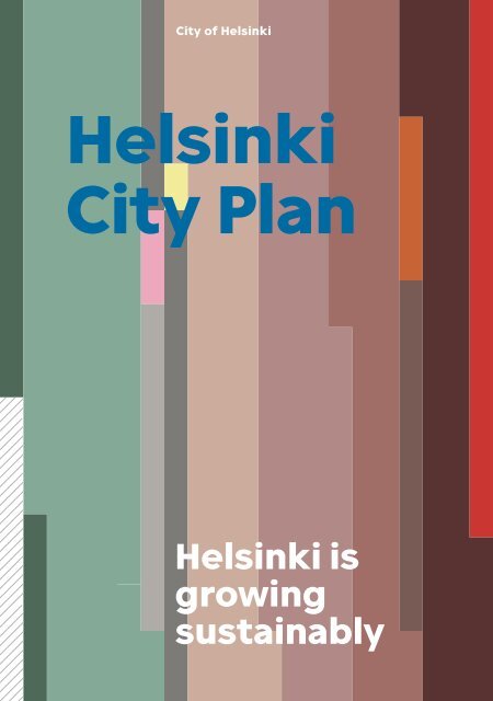
The cover shows<br />
proportional land use<br />
according to primary<br />
purpose as specified<br />
in the city plan. The areas<br />
are predominantly<br />
residential areas shown<br />
in brown. These cover<br />
nearly half of the land<br />
area. Recreational and<br />
green areas form over<br />
a quarter of the overall<br />
area. The city plan map<br />
included explanations<br />
for the colours.<br />
18 Life in a growing <strong>Helsinki</strong><br />
19 The <strong>City</strong> <strong>Plan</strong> increases the housing supply<br />
20 A city-by-the-sea<br />
21 A network of green areas<br />
22 A <strong>City</strong> of diverse business premises<br />
23 An urban city of culture<br />
26 Urban development themes in <strong>Helsinki</strong><br />
27 Global <strong>Helsinki</strong><br />
28 Economies of agglomeration in a denser city<br />
29 Towards a carbon neutral <strong>Helsinki</strong><br />
30 <strong>Plan</strong>ning process and decision-making<br />
31 Interactive planning process<br />
33 <strong>City</strong> Council decision on the <strong>City</strong> <strong>Plan</strong><br />
34 More information about the planning of <strong>Helsinki</strong><br />
34 Publication information<br />
3
A mural on Hämeentie in<br />
Arabianranta.<br />
4 <strong>City</strong> <strong>Plan</strong>ning Department
<strong>Helsinki</strong> is growing<br />
sustainably<br />
The new <strong>Helsinki</strong> <strong>City</strong> <strong>Plan</strong><br />
sets the direction for the<br />
city’s growth over the next<br />
30 or so years. The <strong>Plan</strong><br />
makes it possible to have<br />
approximately 860,000 inhabitants<br />
and 560,000 jobs in<br />
<strong>Helsinki</strong> in 2050. <strong>Helsinki</strong> will<br />
become a denser city than it<br />
is today, with several district<br />
centres connected by public<br />
transport. The city centre will<br />
expand northwards, alongside<br />
motorway-like areas transformed<br />
into city boulevards.<br />
Of the new construction activities, roughly one<br />
third is located in the central city expanding<br />
alongside the city boulevards, one third is<br />
implemented as as infill development in the<br />
new regeneration areas of older estates and<br />
one third in new construction areas, such as<br />
the decommissioned Malmi airfield and in rail<br />
traffic hubs.<br />
Sustainable modes of transport are part<br />
of the <strong>Helsinki</strong> of the future. The aim is to<br />
ensure that every part of the city can be easily<br />
reached by public transport. Walking and<br />
cycling will be given top priority among the<br />
different modes of transport. The urban structure<br />
must be such that everyday services can<br />
be obtained nearby. A dense urban structure<br />
and sustainable transport play a key role in<br />
<strong>Helsinki</strong>’s pursuit of significant reductions in<br />
carbon dioxide emissions. <strong>Helsinki</strong>’s goal is to<br />
be a carbon neutral city by 2050.<br />
Good urban life requires adequate recreational<br />
areas and the opportunity to enjoy<br />
nature. The <strong>Helsinki</strong> of the future will continue<br />
to be a green city whose strengths include<br />
extensive unfragmented green areas, city<br />
forests and valuable cultural environments.<br />
The city’s residents need parks, squares and<br />
marketplaces that serve as meeting places and<br />
event locations. The sea is a strong element<br />
of <strong>Helsinki</strong>’s cityscape, and the city has a long<br />
coastline. This is something we can all continue<br />
to enjoy in the future.<br />
There is high demand for urban housing.<br />
The <strong>City</strong> <strong>Plan</strong> provides the opportunity to<br />
increase the urban housing supply by expanding<br />
the city centre to benefit those who<br />
value urban living. At the same time, the <strong>Plan</strong><br />
ensures that the <strong>Helsinki</strong> of the future will also<br />
include green and natural living environments<br />
for those who value living close to nature.<br />
Mikko Aho<br />
Executive Director,<br />
Urban Environment,<br />
<strong>City</strong> of <strong>Helsinki</strong><br />
<strong>Helsinki</strong> <strong>City</strong> <strong>Plan</strong> 5
The <strong>City</strong> <strong>Plan</strong><br />
in a nutshell<br />
The <strong>City</strong> <strong>Plan</strong> is a long-term<br />
strategic land-use plan used<br />
to guide the development of<br />
<strong>Helsinki</strong>’s city structure. The<br />
<strong>City</strong> <strong>Plan</strong> sets out <strong>Helsinki</strong>’s<br />
path for growing into a city<br />
of some 860,000 inhabitants<br />
by 2050.<br />
The key themes of<br />
the <strong>City</strong> <strong>Plan</strong> are:<br />
Densifying the urban structure. One third<br />
of the residential development outlined in the<br />
<strong>City</strong> <strong>Plan</strong> consists of infill development in existing<br />
districts, mainly the older housing areas.<br />
This means that existing infrastructure can be<br />
utilised, which represents sustainable and economically<br />
sensible urban development.<br />
Expanding the city centre. Central <strong>Helsinki</strong><br />
will continue to be an attractive hub of business,<br />
retail, services, travel and culture in<br />
Finland and the metropolitan area. The aim is to<br />
intensify the density of the areas on the fringes<br />
of the downtown northwards. In addition to the<br />
traditional city centre, another strong business<br />
centre is evolving in eastern central <strong>Helsinki</strong>.<br />
Rail network. The traffic network in the <strong>City</strong><br />
<strong>Plan</strong> is based on a light rail network. Two new<br />
transverse lines east to west will connect the<br />
radial lines to make <strong>Helsinki</strong> into a ‘network city’.<br />
<strong>City</strong> boulevards. The <strong>City</strong> <strong>Plan</strong> proposes that<br />
existing motorway-like traffic routes on the<br />
outskirts of the city be turned into urban city<br />
boulevards with urban areas of living and working<br />
built around these new boulevards.<br />
A Network of Green areas. Recreational and<br />
green areas form an interconnected network.<br />
Transverse green corridors link the main green<br />
areas, creating a ‘green fingers’ structure for<br />
the city.<br />
Local, District and Regional centres. The<br />
aim is to create lively local centres. Important<br />
centres include the district centre of Malmi<br />
and the regional centre in Itäkeskus. Herttoniemi<br />
and Kannelmäki represent key local<br />
centres.<br />
6 <strong>City</strong> <strong>Plan</strong>ning Department
The urban plan divides <strong>Helsinki</strong> into<br />
one-hectare squares, with the primary<br />
intended purpose of land use presented<br />
for each.<br />
<strong>Helsinki</strong>’s population<br />
growth 1900–2010 and<br />
forecast* until 2050<br />
* Rapid growth scenario<br />
800 000<br />
600 000<br />
400 000<br />
200 000<br />
1900<br />
1910<br />
1920<br />
1930<br />
1940<br />
1950<br />
1960<br />
1970<br />
1980<br />
1990<br />
2000<br />
2010<br />
2020<br />
2030<br />
2040<br />
2050<br />
A <strong>City</strong>-by-the-sea. The <strong>City</strong> <strong>Plan</strong> presents new<br />
opportunities for strengthening <strong>Helsinki</strong>’s maritime<br />
character. A seaside trail follows <strong>Helsinki</strong>’s<br />
coastline. In the archipelago, new opportunities are<br />
created by the Vallisaari, Kuninkaansaari, Kuivasaari<br />
and Isosaari islands opening up for the public,<br />
having previously been in military use.<br />
New districts. The Malmi airfield area is the<br />
largest entirely new development site for residential<br />
construction. It will become a neighbourhood<br />
for as many as 25,000 residents.<br />
Office parks and light industrial estate. Examples<br />
of important commercial zones include<br />
Herttoniemi and Pitäjänmäki. Mixed-use areas in<br />
the city centre also hold significant potential for<br />
business activity.<br />
Platform of Urban<br />
Development<br />
The <strong>City</strong> <strong>Plan</strong> points strongly towards<br />
the densification of the urban<br />
structure and the development of<br />
transverse rail lines. It also ensures<br />
that <strong>Helsinki</strong> will continue to have<br />
extensive unfragmented green areas<br />
in the future.<br />
The <strong>City</strong> <strong>Plan</strong> is a plan that a wide<br />
variety of parties can use as a starting<br />
point for planning and discussion. In<br />
addition to the <strong>City</strong> of <strong>Helsinki</strong> itself,<br />
its potential users include other public<br />
sector agencies, city planning experts,<br />
commercial operators and local<br />
residents.<br />
<strong>Helsinki</strong> <strong>City</strong> <strong>Plan</strong><br />
7
Summer activities at Aurinkolahti<br />
beach in Vuosaari.<br />
8<br />
<strong>City</strong> <strong>Plan</strong>ning Department
<strong>Helsinki</strong> <strong>City</strong> <strong>Plan</strong><br />
9
Densifying<br />
the urban<br />
<strong>Helsinki</strong><br />
The <strong>Helsinki</strong> of tomorrow will<br />
be a denser city than it is today.<br />
Transverse rail lines will be<br />
developed to complement the<br />
existing radial lines leading into<br />
the city centre. Stations will<br />
become important traffic hubs<br />
and the urban structure around<br />
them will become denser. The <strong>City</strong><br />
<strong>Plan</strong> presents the opportunity to transform motorwaylike<br />
entry routes into city boulevards and build the<br />
urban environment along them. The largest entirely<br />
new area for new construction is the former Malmi<br />
airfield, which can be developed to provide housing<br />
for 25,000 residents.<br />
10 <strong>City</strong> <strong>Plan</strong>ning Department
An impressive tower area is being planned in<br />
central Pasila north of <strong>Helsinki</strong> city centre.<br />
Expanding the city centre<br />
The <strong>City</strong> <strong>Plan</strong> presents the<br />
opportunity to develop a<br />
strong new business<br />
district in eastern central<br />
<strong>Helsinki</strong>.<br />
The Pasila–Vallila–Kalasatama axis, which<br />
follows Teollisuuskatu, will become a significant<br />
business district comparable to the<br />
current city centre. Teollisuuskatu will become<br />
the main street of eastern central <strong>Helsinki</strong>,<br />
connecting the new centres of Pasila and Kalasatama.<br />
Along the axis there lie the business<br />
districts of Vallila and Tukkutori, Sörnäinen<br />
Metro station, the Konepaja area and Suvilahti<br />
cultural centre, surrounded by densely-built<br />
residential neighbourhoods. From Pasila, the<br />
densely built city centre expands to the north<br />
and further in the direction of Käpylä.<br />
The <strong>City</strong> <strong>Plan</strong> also supports supplementary<br />
construction in many of central seaside areas,<br />
such as Hakaniemenranta and the south-eastern<br />
shore of Katajanokka. In Katajanokka, it is<br />
possible to obtain new residential space for<br />
slightly more than 2,000 inhabitants by-thesea<br />
by rearranging the existing thoroughfares<br />
and parking lots in the harbour. Hakaniemi will<br />
become an important public transport node<br />
once the Laajasalo tram line is completed, possibly<br />
to be complemented later by the Pisararata<br />
rail line. Development in the area will be<br />
boosted by the overhaul of Hakaniemi bridge.<br />
This will facilitate supplementary construction<br />
and enable the development of shoreline<br />
areas. In the city centre, densification of the<br />
urban structure will also include supplementary<br />
construction inside city blocks.<br />
<strong>Helsinki</strong> <strong>City</strong> <strong>Plan</strong> 11
New districts along<br />
boulevards<br />
One of the major land use solutions in the<br />
<strong>City</strong> <strong>Plan</strong> is the opportunity to transform<br />
motorway-like thoroughfares into city<br />
boulevards inside Ring I.<br />
The development of city boulevards is primarily<br />
about the extension of central <strong>Helsinki</strong>.<br />
Valuable green areas can be preserved by<br />
using the protective zones of motorway-like<br />
areas for construction. The city boulevards will<br />
constitute new urban districts that will feature<br />
a mixed urban structure consisting of housing,<br />
jobs and services.<br />
The transformation of motorway-like<br />
thoroughfares into boulevards requires<br />
investments in public transport and solutions<br />
for increasing the popularity of walking and<br />
cycling. They must be presented as genuine<br />
alternatives for getting around the city. There<br />
will also be space left for those who need to<br />
drive their own cars. The aim is to develop a<br />
functional and safe traffic system that emphasises<br />
sustainable modes of transport rather<br />
than forcing private cars out of <strong>Helsinki</strong>.<br />
The character of the existing motorway-like<br />
thoroughfares will be changed by their<br />
transformation into boulevards for living and<br />
working. They will evolve from routes conveying<br />
fast automobile traffic into streets that serve<br />
multiple modes of transport. <strong>City</strong> boulevards<br />
will serve public transport, pedestrians and<br />
cyclists, as well as motorists. <strong>Helsinki</strong> also has<br />
main streets resembling city boulevards, such<br />
as Mannerheimintie and Mäkelänkatu.<br />
Speed limits on the city boulevards will be<br />
lower than on the existing entry routes. Some<br />
multi-level junctions will be replaced by level<br />
intersections. To ensure smooth traffic flow,<br />
it is important, however, to be able to utilise<br />
multi-level junctions at certain points where<br />
the traffic is particularly heavy. Likewise,<br />
smooth crossings must be implemented at<br />
points where light rail lines and bicycle paths<br />
intersect with city boulevards.<br />
All entry routes to <strong>Helsinki</strong> inside Ring I<br />
can be transformed into city boulevards in the<br />
future. The Vihdintie and Itäväylä city boulevards<br />
will extend to the city border, as they<br />
are already quite street-like. In addition to the<br />
entry routes, Laajasalontie is designated a city<br />
boulevard in the <strong>City</strong> <strong>Plan</strong>.<br />
Dense block along future urban boulevard.<br />
12 <strong>City</strong> <strong>Plan</strong>ning Department
An image of the<br />
northern part of<br />
Pikku Huopalahti.<br />
A view along<br />
Mannerheimintie.<br />
Motorway-like entry routes in <strong>Helsinki</strong><br />
Amount of vehicles year 2014<br />
Highway<br />
Vihdintie<br />
28 000 vehicles/<br />
weekday<br />
Highway<br />
Hämeenlinnanväylä<br />
48 000 vehicles/<br />
weekday<br />
Highway<br />
Tuusulanväylä<br />
30 000 vehicles/<br />
weekday<br />
Highway<br />
Lahdenväylä<br />
56 000 vehicles/<br />
weekday<br />
<br />
<br />
<br />
<br />
<br />
Highway Turunväylä<br />
38 000 vehicles/<br />
weekday<br />
<br />
<br />
<br />
Highway Länsiväylä<br />
69 000 vehicles/<br />
weekday<br />
Highway Itäväylä<br />
49 000 vehicles/<br />
weekday<br />
Street Laajasalontie<br />
23 000 vehicles/<br />
weekday<br />
13
Developing Local, District and Regional<br />
centres in <strong>Helsinki</strong><br />
The Oulunkylä<br />
station area and<br />
the area along<br />
Käskynhaltijantie<br />
will be densified.<br />
Raide-Jokeri tranversal<br />
light-rail line<br />
will make Oulunkylä<br />
station a rail transport<br />
junction.<br />
The centre of Malmi<br />
will be developed<br />
into the centre of<br />
north-eastern <strong>Helsinki</strong>.<br />
The objectives<br />
for the development<br />
include creating<br />
more lively urban<br />
space as well as<br />
better streets, and<br />
attracting residents,<br />
services and jobs<br />
into the centres,<br />
close to the stations.<br />
The Kannelmäki<br />
station area will be<br />
condensed further<br />
and its functional<br />
link with the Kaari<br />
shopping centre<br />
will be improved.<br />
The Pitäjänmäki<br />
station area will<br />
be condensed and<br />
new residential<br />
construction will be<br />
introduced at the<br />
public transport<br />
junction.<br />
The centre of<br />
Hertto niemi<br />
around the Metro<br />
station will develop<br />
into a diverse<br />
hub of housing,<br />
services and jobs.<br />
The Herttoniemi<br />
business district will<br />
remain primarily in<br />
commercial use.<br />
A new commercial<br />
centre will be built<br />
next to the current<br />
one. Later, Laajasa<br />
lontie will be<br />
transformed into a<br />
city boulevard, with a<br />
significant amount of<br />
supplementary construction<br />
along it.<br />
14 <strong>City</strong> <strong>Plan</strong>ning Department
Construction is<br />
planned for the centre<br />
of Viikki, along<br />
the Rail-Jokeri light<br />
rail line. The aim is to<br />
better connect the<br />
surrounding districts<br />
with each other.<br />
The centre of<br />
Kontula will be<br />
developed as a<br />
hub of commercial<br />
services, offices and<br />
housing.<br />
The development of<br />
Myllypuro, which is<br />
already well underway,<br />
will continue.<br />
The campus of the<br />
Metropolia University<br />
of Applied Sciences<br />
will be completed<br />
next to the Metro<br />
station. The future<br />
introduction of the<br />
Science Tram will<br />
link Myllypuro to the<br />
network of higher<br />
education institutes.<br />
The centre of<br />
Vuosaari will grow<br />
denser and become<br />
more multifunctional.<br />
The centre of Vuosaari<br />
and Vuosaari<br />
Harbour will be<br />
connected by rail.<br />
The potential for<br />
supplementary<br />
construction in<br />
Itäkeskus amounts<br />
to as much as one<br />
million square<br />
metres of floor<br />
space.<br />
Local, District and<br />
Regional centres<br />
The <strong>City</strong> <strong>Plan</strong> offers <strong>Helsinki</strong> the<br />
opportunity to develop active and<br />
vibrant centres in suburban areas<br />
as well.<br />
Local and district centres can only develop if they have a sufficiently<br />
large population base. An adequate number of residents<br />
in a sufficiently dense environment creates the conditions for the<br />
availability of diverse services. The local, district and regional centres<br />
will have a mixed urban structure with streetside businesses.<br />
Itäkeskus is an important regional centre, whereas Malmi is a major<br />
district centre. Local centres such as Herttoniemi and Kannelmäki<br />
play a key role for its residents.<br />
Itäkeskus has been growing continuously and is already now a<br />
very lively hub. The <strong>City</strong> <strong>Plan</strong> allocates significant new construction<br />
potential to Itäkeskus. According to a sketch proposal prepared for<br />
the area, the supplementary construction potential for both residential<br />
and business premises in Itäkeskus amounts to one million<br />
square metres of floor area.<br />
Malmi is a district centre in the north-east of <strong>Helsinki</strong> and is<br />
an important junction in the urban rail network. Malmi has great<br />
growth potential and may become a major business and administration<br />
centre as rail connections gain importance and the area<br />
becomes more accessible with the arrival of the new transversal<br />
light-rail line Jokeri 2. The development of the Malmi airfield area<br />
will expand the population base of the area.<br />
Kannelmäki is an important local centre in western <strong>Helsinki</strong>. The<br />
<strong>City</strong> <strong>Plan</strong> strengthens the position of the neighbourhood around the<br />
Kannelmäki station, giving it the status of a large business and service<br />
centre. In this way, the consumer goods retail services away from the<br />
area around the station can be better tied to the station centre.<br />
<strong>Plan</strong>s have already been prepared for the centre of Herttoniemi,<br />
where the business and residential building base will expand<br />
significantly. Herttoniemi is a local centre for the south-eastern<br />
suburbs. Some 100,000 people live in its impact area. The centre of<br />
Herttoniemi can be extended towards the city centre by covering<br />
portions of Itäväylä and Metro.<br />
The main objectives for the development of these centres include<br />
creating more lively urban space as well as better streets, attracting<br />
new inhabitants and jobs to the immediate vicinity of the stations.<br />
<strong>Helsinki</strong> <strong>City</strong> <strong>Plan</strong> 15
A Network city<br />
In order to function, a densely built city<br />
requires an efficient public transport system.<br />
As the population grows, so does the number<br />
of journeys made. <strong>Helsinki</strong> wants to promote<br />
sustainable modes of transport, such as walking,<br />
cycling and public transport, as genuinely<br />
competitive alternatives to the extensive use<br />
of private cars. The traffic network in the <strong>City</strong><br />
<strong>Plan</strong> is based on a light rail network. Preparations<br />
are also made for the expansion of the<br />
Metro and railway system.<br />
The light rail lines will extend radially from<br />
the city centre to at least Ring I, primarily along<br />
boulevard corridors. Some of the lines will go on<br />
as far as the city border. Transverse lines connect<br />
the radial lines into a traffic network. The current<br />
cross-town bus lines Jokeri 1 and 2 will be transferred<br />
onto light-rails, significantly improving<br />
transverse connections. A new archipelago tram<br />
route via Laajasalo to Vartiosaari and thence via<br />
Ramsinniemi towards Meri-Rastila in the district<br />
of Vuosaari, some 14 kilometres to the east,<br />
would render the seaside areas of the city better<br />
accessibility by public transport.<br />
A new street connection linking Mäkelänkatu<br />
and Hämeentie streets is to be opened solely<br />
for public transport in Vallilanlaakso, just north<br />
of the city centre. The new public transport<br />
street enables more efficient use of the existing<br />
public transport lines and the setting up of new<br />
connections. The new connection will be utilised<br />
by the so-called science tram line which links<br />
Meilahti and Otaniemi (in Espoo) with Kumpula<br />
and possibly Myllypuro in the east of the city.<br />
The metro and Raide-<br />
Jokeri are essential<br />
elements of future railway<br />
traffic in <strong>Helsinki</strong>.<br />
16 <strong>City</strong> <strong>Plan</strong>ning Department
Malmi airfield to be developed<br />
into a new city district<br />
The Malmi airfield is the<br />
largest new construction<br />
area in the <strong>City</strong> <strong>Plan</strong>.<br />
With potential to build homes for 25,000 <strong>Helsinki</strong><br />
residents, the total floor area target is 1.2<br />
million square metres, of which 100,000 square<br />
metres would be allocated to business premises<br />
and services. Once this area is developed,<br />
it will have a significant impact on the district<br />
centre of Malmi and the entire north-eastern<br />
<strong>Helsinki</strong>. The aim is to create a new district with<br />
a strong local centre of its own.<br />
There are tram lines planned to serve the<br />
Malmi airfield area. In future, the area will be<br />
a junction for the transverse Raide-Jokeri 2<br />
light-rail line and a line that goes from the city<br />
centre north via Viikki and through the airfield<br />
area. On the main Lahdenväylä motorway in the<br />
north-east of the city and across Lahdenväylä<br />
in Kivikko, the planned new Tattarisilta junction<br />
will also provide the area with a better connection<br />
to the street network of eastern <strong>Helsinki</strong>.<br />
The planned area will be a high-quality<br />
district with a diverse population structure and<br />
wide range of housing options. The plans include<br />
preparations for locating some 2,000 jobs<br />
in the area. The planning of the Malmi area takes<br />
into consideration the local strengths, such as<br />
echoes of the airfield’s old runways, open spaces<br />
and far away views. The green network in the<br />
area is intended to be connected to the Kivikko<br />
recreational park by a bridge built over Lahdenväylä.<br />
A continuous circular outdoor recreation<br />
trail is also part of the plans for the area.<br />
<strong>Helsinki</strong> <strong>City</strong> <strong>Plan</strong> 17
Life in a<br />
growing<br />
<strong>Helsinki</strong><br />
The <strong>City</strong> <strong>Plan</strong> is<br />
necessary for<br />
<strong>Helsinki</strong> to respond<br />
to housing demand<br />
in the coming years.<br />
Housing prices have<br />
risen rapidly due to<br />
supply not being<br />
able to keep up with<br />
demand. At the same time, the growth of<br />
the amount of living space per person has<br />
stalled. People in <strong>Helsinki</strong> live in closer<br />
quarters than the rest of Finland and pay<br />
more for housing. The <strong>City</strong> <strong>Plan</strong> also aims to<br />
ensure that as it grows and becomes denser,<br />
<strong>Helsinki</strong> will remain a pleasant maritime city<br />
that is close to nature, a city that provides<br />
good conditions for business activity and<br />
has a thriving urban culture.<br />
18 <strong>City</strong> <strong>Plan</strong>ning Department
The <strong>City</strong> <strong>Plan</strong> increases<br />
the housing supply<br />
<strong>Helsinki</strong>’s growth and the<br />
high demand for housing<br />
have led to a significant<br />
increase in housing costs.<br />
Living space in <strong>Helsinki</strong><br />
1985–2014<br />
m²/person<br />
35<br />
The <strong>City</strong> <strong>Plan</strong> presents the opportunity to increase<br />
the housing supply. This is intended to influence<br />
the development of prices. The construction programme<br />
set out by the <strong>City</strong> <strong>Plan</strong> will substantially<br />
diversify the housing supply in different districts.<br />
Housing prices have increased quite sharply<br />
in the city centre. This indicates that the housing<br />
supply in the urban environment has not been<br />
adequate. The <strong>City</strong> <strong>Plan</strong> aims to change this. Going<br />
forward, <strong>Helsinki</strong> will be better equipped to<br />
build housing in a dense urban environment.<br />
The amount of living space per person in<br />
<strong>Helsinki</strong> grew rapidly from the 1960s to the late<br />
1980s as income levels increased and housing<br />
production was relatively high. Since then, and<br />
particularly since the latter half of the 1990s,<br />
this trend slowed down significantly. In recent<br />
years, the amount of living space per person in<br />
<strong>Helsinki</strong> has even turned to a slight decline.<br />
The supplementary construction proposed<br />
in the <strong>City</strong> <strong>Plan</strong> is also aimed at minimising the<br />
30<br />
25<br />
1985<br />
1990<br />
1995<br />
2000<br />
2005<br />
2010<br />
2014<br />
segregation of residential areas. Districts can<br />
evolve with their own independent characteristics<br />
within the city. Investments can ensure the<br />
vitality of districts and improve their image.<br />
The <strong>City</strong> has a long history of housing policy<br />
in which social sustainability is a key principle.<br />
This means that different kinds of local residents<br />
and groups have the opportunity to find housing<br />
that suits their needs and financial standing.<br />
<strong>Helsinki</strong> will be developed in such a way that new<br />
areas will become districts with their own unique<br />
charac ter and a diverse population structure.<br />
<strong>Helsinki</strong> <strong>City</strong> <strong>Plan</strong> 19
A <strong>City</strong> by-the-sea<br />
The sea has a strong<br />
presence in <strong>Helsinki</strong>. The<br />
city’s marine character is one<br />
of its major strengths.<br />
<strong>Helsinki</strong> offers the opportunity for seaside living<br />
as well as taking advantage of the sea in both economic<br />
activities and in recreation. The sea plays a<br />
significant role in the <strong>City</strong> <strong>Plan</strong>. One of the theme<br />
maps of the <strong>City</strong> <strong>Plan</strong> shows the beaches and islands<br />
allocated for recreational use, for in s tance.<br />
It also shows the seaside trail which significantly<br />
improves the accessibility of the sho reline to pedest<br />
rians and cyclists. You can get to the shore<br />
almost anywhere in <strong>Helsinki</strong>, and the majority of<br />
the shoreline is accessible to the public.<br />
The islands off <strong>Helsinki</strong> also present new<br />
op por tunities. Islands previously used by the defence<br />
administration have already been released<br />
for civilian use, with more to follow in the future.<br />
Such islands include Vallisaari, Kuninkaansaari,<br />
Kuivasaari and Isosaari. The aim is to open up<br />
the islands for recreational use. Vallisaari and<br />
Kuninkaansaari islands are located only a few<br />
kilometres from the city centre of <strong>Helsinki</strong> and<br />
from the new Jätkäsaari, Kalasatama and Kruunuvuorenranta<br />
areas under construction.<br />
The development of Vallisaari, Kuninkaansaari,<br />
Kuivasaari and Isosaari will be carried out<br />
in a manner that will respect the islands’ cultural<br />
and military history as well as their wild nature.<br />
In Isosaari, the existing infrastructure – roads,<br />
harbours, power lines, sanitation and a wastewater<br />
treatment plant – makes possible the imp lemen<br />
tation of other facilities, such as an oil spill<br />
response centre, on the island.<br />
The city’s location by the sea opens many<br />
de velopment opportunities for <strong>Helsinki</strong>: from<br />
general tourism, wilderness safaris and recreational<br />
fishing to improving the maritime infrastructure<br />
and accessibility of the archipelago.<br />
Islands for recreational use<br />
off the coast of <strong>Helsinki</strong><br />
Vallisaari<br />
Kuninkaansaari<br />
Kuivasaari<br />
Isosaari<br />
Image of Vallisaari.<br />
20 <strong>City</strong> <strong>Plan</strong>ning Department
Network of Green areas<br />
Recreational and green areas form an<br />
interconnected network in the <strong>City</strong> <strong>Plan</strong>.<br />
Its trunk comprises the ‘green fingers’<br />
extending into the larger metropolitan<br />
region, other park areas and transverse<br />
green corridors.<br />
In the <strong>City</strong> <strong>Plan</strong>, transverse green corridors connect the broader<br />
radial green areas and recreational areas, known as ‘green fingers’.<br />
The interconnecting corridors may vary from man-made structures to<br />
natural wooded areas. Where necessary, green overpasses or underpasses<br />
will be built.<br />
The green and recreational network as well as the urban nature net <br />
work along with the related objectives are presented in the theme maps.<br />
The ‘recreational network’ theme map presents the objectives for developing<br />
a recreational entity comprised of large continuous re creational<br />
areas, transverse green corridors between neighbourhood parks, river<br />
banks, city centre green areas, the seaside trail and landlocked bays.<br />
The ‘urban nature’ theme map presents nature conservation areas,<br />
Natura network areas, the areas currently included in <strong>Helsinki</strong>’s nature<br />
conservation programme, the woodland network, the meadowland<br />
network and the core areas of urban nature.<br />
*Theme maps are published at the <strong>City</strong> <strong>Plan</strong> website www.yleiskaava.fi 21
A <strong>City</strong> of diverse<br />
business premises<br />
A mixed urban structure<br />
is often a good operating<br />
environment for businesses,<br />
but commercial zones have<br />
their advantages.<br />
The economic activities in such areas will<br />
include businesses that cannot be situated<br />
in a mixed urban structure because of<br />
accessibility requirements, because their<br />
production processes cause great inconvenience<br />
to people or because businesses<br />
benefit from proximity to each other.<br />
Commercial zones need to be large<br />
enough and allow for growth of the companies.<br />
In <strong>Helsinki</strong>, there are two largescale<br />
commercial zones outside the city<br />
core which are easily accessible by public<br />
transport. These are Pitäjänmäki and<br />
Herttoniemi–Roihupelto.<br />
Business areas in <strong>Helsinki</strong><br />
Tapanila<br />
Suutarila<br />
Heikinlaakso<br />
Malmi<br />
Metsälä<br />
The area along<br />
Vihdintie in<br />
Konala<br />
Tattarisuo<br />
Tattariharju<br />
Kivikko<br />
Reimarla<br />
Kurkimäki<br />
Pitäjänmäki<br />
Viikki<br />
Vallila<br />
industrial zone<br />
The Tukkutori<br />
area in<br />
Kalasatama<br />
Herttoniemi<br />
22 <strong>City</strong> <strong>Plan</strong>ning Department
An urban city<br />
of culture<br />
The <strong>Helsinki</strong> of 2050 is<br />
a boldly urban city. The<br />
successful cities of the future<br />
are cities that residents<br />
enjoy and people elsewhere<br />
want to move to.<br />
A work of art<br />
entitled Unelma<br />
(“Dream”) at<br />
Sitra square in<br />
Kannelmäki.<br />
<strong>Helsinki</strong> is already a fascinating stage of urban<br />
culture. A wide variety of events take place in<br />
<strong>Helsinki</strong>’s districts. Well-known events such as<br />
the Restaurant Day and Cleaning Day started<br />
this way, along with various small and large<br />
events and phenomena that arise from the<br />
community spirit among local residents.<br />
A more urban <strong>Helsinki</strong> means more<br />
street-level shops in blocks of flats, bicycle<br />
lanes, the clatter of trams, coffee at the market<br />
place, international flavour, urban productivity,<br />
seaside saunas and district festivals. The<br />
higher population and workplace density<br />
enable easy access to local services. Intertwining<br />
housing, jobs and services more closely<br />
with each other will enable the development<br />
of vibrant urban environments, even outside<br />
the city centre.<br />
<strong>Helsinki</strong> <strong>City</strong> <strong>Plan</strong> 23
24 <strong>City</strong> <strong>Plan</strong>ning Department
<strong>Helsinki</strong> <strong>City</strong> <strong>Plan</strong> 25
Urban<br />
development<br />
themes in<br />
<strong>Helsinki</strong><br />
The <strong>Helsinki</strong> of the future<br />
is a city that is successful<br />
in the international<br />
competition between<br />
cities. It is a city that offers<br />
good connections to the<br />
world and is an attractive<br />
location for businesses. A<br />
denser city offers economies of agglomeration<br />
to businesses along with an effective job<br />
market. <strong>Helsinki</strong> will also ensure that it operates<br />
in line with the principles of sustainable<br />
development. <strong>Helsinki</strong>’s goal is to be a carbon<br />
neutral city by 2050.<br />
26 <strong>City</strong> <strong>Plan</strong>ning Department
Direct scheduled flight<br />
destinations from <strong>Helsinki</strong>-<br />
Vantaa Airport in 2015<br />
Number of passengers<br />
at <strong>Helsinki</strong>-Vantaa<br />
Airport 1995–2015<br />
millions of passengers<br />
4<br />
North<br />
America<br />
114 17<br />
Europe and<br />
the Middle East<br />
Asia<br />
15<br />
10<br />
5<br />
0<br />
1995 2000 2005 2010 2015<br />
Global<br />
<strong>Helsinki</strong><br />
The 15 <strong>Helsinki</strong> city region is<br />
the engine that powers<br />
10<br />
development throughout<br />
Finland. International<br />
5<br />
connections are essential for<br />
the region’s vitality.<br />
0<br />
Without 1995effective 2000 connections, 2005 2010 <strong>Helsinki</strong> 2015 cannot<br />
serve businesses that operate in the global<br />
markets, attract international labour and students,<br />
or be an appealing tourist destination.<br />
The <strong>City</strong> <strong>Plan</strong> helps ensure that <strong>Helsinki</strong> has<br />
the necessary conditions in place for international<br />
connections and their development.<br />
15<br />
In maritime transport, traffic between Tallinn<br />
and 10 <strong>Helsinki</strong> will grow rapidly in the coming<br />
decades in terms of passenger traffic as well as<br />
cargo and cars. The <strong>City</strong> <strong>Plan</strong> ensures that the<br />
Port 5 of <strong>Helsinki</strong> continues to have the necessary<br />
conditions for effective operation of its<br />
harbours in the city centre and in Vuosaari.<br />
0<br />
Finland’s location in the northernmost part<br />
2011 2012 2013 2014<br />
of Europe makes air traffic particularly signi<br />
15<br />
10<br />
5<br />
0<br />
2011 2012 2013 2014<br />
ficant. <strong>Helsinki</strong> has developed into a strong<br />
hub for air traffic between Europe and Asia.<br />
No other city in Northern Europe offers the<br />
range of direct flights to Asian metropolises<br />
that <strong>Helsinki</strong> does. The <strong>City</strong> <strong>Plan</strong> supports the<br />
development of connections between <strong>Helsinki</strong>’s<br />
city centre and the international airport,<br />
as well as the supply of business premises.<br />
<strong>Helsinki</strong>-Vantaa Airport is currently implementing<br />
a significant investment programme that<br />
enables the growth of passenger volume.<br />
<strong>Helsinki</strong>’s city centre is the international<br />
display window of the metropolitan area. Tourists<br />
are an important target group and <strong>Helsinki</strong><br />
wants to build itself a profile as an attractive<br />
travel destination. Cruise ships bring significant<br />
tourist flows right into the heart of the city.<br />
<strong>Helsinki</strong> <strong>City</strong> <strong>Plan</strong> 27
Economies of agglomeration<br />
in a denser city<br />
<strong>Helsinki</strong> city centre is the most important<br />
commercial centre in Finland.<br />
It is comprised of multiple historical<br />
layers and is highly acces sible. The<br />
<strong>City</strong> <strong>Plan</strong> aims to ensure that the<br />
city centre will maintain its strong<br />
position in the future.<br />
Measured by productivity, the city centre is one of the top<br />
areas in the country. Keeping the city centre vibrant is important<br />
for the entire Finnish economy. The economies of agglomeration<br />
is an important concept for urban productivity.<br />
As firms in related fields of business cluster together, they<br />
will have greater specialisation and division of labour, resulting in<br />
a significant increase in productivity. The conditions for an effective<br />
labour market are better when there is a higher ava i lability<br />
of labour, a sufficient pool of skilled and competent people and<br />
opportunities for specialisation. This development also presents<br />
opportunities to the members of the labour for ce. The growing<br />
number of businesses creates more diverse opportunities to<br />
find a job that suits one’s needs, education and experience. The<br />
growing number of businesses also leads to gre ater division of<br />
work between them, while competition leads to costs remaining<br />
under control, higher quality and increased productivity.<br />
The <strong>City</strong> <strong>Plan</strong> ensures that the land use-related conditions<br />
for the economies of agglomeration are in place. The city<br />
plan ners of <strong>Helsinki</strong> have been aiming to strengthen the city’s<br />
densely built centre for a long time. For years, the city centre<br />
has been growing inwards. New business premises have been<br />
built in courtyards and below street level. This has enabled the<br />
expansion of the existing central business district. Opportunities<br />
for such developments, along with investments in the city<br />
centre, will continue to be available in the future.<br />
In the <strong>City</strong> <strong>Plan</strong>, the city centre is developed as a functionally<br />
mixed area of metropolitan uses, housing, commercial and public<br />
services, offices, administration, parks, recreational and outdoor<br />
services and urban culture. Ground floor premises and premises<br />
that open into the street should be preferably designated as retail<br />
or office space. Sustainable modes of transport, particularly<br />
pedestrian and bicycle traffic, will be favoured.<br />
The development<br />
of rents for office<br />
premises in <strong>Helsinki</strong>’s<br />
city centre<br />
rent index, 1993 = 100<br />
175<br />
150<br />
125<br />
100<br />
1993<br />
1998<br />
2003<br />
2008<br />
Source: <strong>Helsinki</strong> Region Trends/KTI<br />
Property Information<br />
2013<br />
2016<br />
28 <strong>City</strong> <strong>Plan</strong>ning Department
<strong>Helsinki</strong>’s greenhouse<br />
gas emissions are<br />
declining: emissions<br />
in <strong>Helsinki</strong> 1990–2015<br />
1000 tonnes CO ² -eq., source: HSY<br />
4000<br />
3000<br />
2000<br />
1000<br />
0<br />
1990<br />
2000<br />
2010<br />
2015<br />
Towards a carbon<br />
neutral <strong>Helsinki</strong><br />
<strong>Helsinki</strong> is committed to<br />
significantly reducing<br />
climate emissions.<br />
<strong>Helsinki</strong> aims to achieve a 30% reduction in<br />
climate emissions by 2020 and carbon neutrality<br />
by 2050. The <strong>City</strong> <strong>Plan</strong> is one of the key instruments<br />
for achieving this goal.<br />
Land use planning is directly linked to traffic<br />
emissions. The more fragmented the community<br />
structure, the higher the emissions. The<br />
<strong>City</strong> <strong>Plan</strong> sets out a path towards a denser urban<br />
structure, with population growth allocated<br />
to areas that are effectively served by public<br />
transport. This substantially reduces traffic-related<br />
climate emissions compared to alternative<br />
growth scenarios. The alternative would be for<br />
the region’s population growth to be dispersed<br />
over an increasingly large geographical area of<br />
urban sprawl, which would increase the need for<br />
more journeys between the outer regional areas<br />
and the city, and, in particular, private car traffic,<br />
which in turn, would increase emissions.<br />
Besides traffic, <strong>Helsinki</strong>’s other significant<br />
sources of greenhouse gas emissions include<br />
the production and consumption of energy. With<br />
respect to emissions reduction methods related<br />
to the energy system, the <strong>City</strong> <strong>Plan</strong> plays a role<br />
in facilitating various low-emission solutions<br />
and development paths. Achieving emissions<br />
reduction targets will require a multidisciplinary<br />
strategic planning effort, to which the <strong>City</strong> <strong>Plan</strong><br />
will introduce the land use planning perspective.<br />
<strong>Helsinki</strong> <strong>City</strong> <strong>Plan</strong> 29
<strong>Plan</strong>ning<br />
process and<br />
decisionmaking<br />
The making of the <strong>City</strong><br />
<strong>Plan</strong> has been an open<br />
and interactive process<br />
that has taken more than<br />
four years. A large amount<br />
of experience-based<br />
information has been<br />
collected from citizens.<br />
This is important, as the<br />
<strong>City</strong> <strong>Plan</strong> will have a very long-term impact on<br />
the city’s development. The process has been<br />
made more challenging by the fact that the<br />
<strong>City</strong> <strong>Plan</strong> represents a new kind of strategic<br />
<strong>Plan</strong>. On the one hand, the wider city centre<br />
area now becomes an inclusive area defined<br />
as ‘metropolitan mixed-uses’, and on the other<br />
hand, the outer suburbs are more loosely<br />
described as land-uses. The <strong>City</strong> <strong>Plan</strong> divides<br />
<strong>Helsinki</strong> into one-hectare squares, with the<br />
primary intended purpose of land<br />
use presented for each.<br />
30 <strong>City</strong> <strong>Plan</strong>ning Department
Interactive planning process<br />
The <strong>City</strong> <strong>Plan</strong> has been made in an open and<br />
interactive manner. The process has included a<br />
large number of various events, the process and<br />
the <strong>City</strong> <strong>Plan</strong> materials have been extensively<br />
published on the web, an online survey was<br />
conducted on <strong>Helsinki</strong> residents, blogs have<br />
served as a platform for discussion, young people<br />
have had their own events tailored to their<br />
interests, city planners have actively participated<br />
in events organised by various associations,<br />
and the <strong>City</strong> <strong>Plan</strong> has been the subject of active<br />
discussion and debate on various social media<br />
platforms. A very broad range of various interactive<br />
methods have been employed during the<br />
planning process to ensure that citizens can be<br />
closely involved in many ways.<br />
2013<br />
Vision seminars. The vision for the <strong>City</strong><br />
<strong>Plan</strong> was drafted in 2013. The <strong>City</strong> <strong>Plan</strong>’s<br />
themes and background phenomena,<br />
including some that are quite complex,<br />
were communicated to local residents<br />
by arranging a series of theme seminars.<br />
A total of 10 events were held in Laituri,<br />
<strong>Helsinki</strong>’s <strong>City</strong> <strong>Plan</strong>ning department’s own<br />
exhibition and workshop space, with some<br />
1,000 citizens participating. The themes of<br />
the seminars included the growth of the<br />
city, housing, traffic, recreation and urban<br />
culture, business and competitiveness,<br />
climate change and services.<br />
Map survey. The city planners wanted to hear<br />
the views of as many citizens as possible to<br />
serve as the foundation for drafting the <strong>City</strong><br />
<strong>Plan</strong>. To this end, the <strong>Helsinki</strong> 2050 map survey<br />
was imple mented in late 2013 in the form of an<br />
online inter-active opportunity for residents to<br />
get involved. Visitors to the website could mark<br />
the online map with references to good construction<br />
locations, areas where not to build,<br />
important green areas or new traffic solutions,<br />
for example. A total of approximately 4,700 people<br />
participa ted in the survey and made more<br />
than 33,000 entries in the map. The survey<br />
materials have been carefully analysed and all<br />
of the material has also been published as open<br />
data. The material represents a comprehensive<br />
and internationally unique database of citizens’<br />
views on their city’s future development.<br />
2013<br />
autumn<br />
<strong>Helsinki</strong> <strong>City</strong> <strong>Plan</strong> 31
2014<br />
spring<br />
Spend a moment as a city planner. A series<br />
of workshops titled Spend a moment as a<br />
city planner were arranged in spring 2014.<br />
The purpose of the workshops was to work<br />
together with local residents to think about<br />
what <strong>Helsinki</strong> should be like in 2050. The aim<br />
was to obtain good ideas from <strong>Helsinki</strong> residents<br />
to support the planning process. The<br />
workshops were attended by 250 participants<br />
who prepared 27 plans, which were then<br />
made available to the public via the <strong>City</strong> <strong>Plan</strong><br />
website and in Laituri exhibition space. The<br />
workshop outcomes were also published on<br />
the <strong>City</strong> <strong>Plan</strong> website blog, where they have<br />
been read by nearly 2,000 local residents.<br />
<strong>City</strong> <strong>Plan</strong>ning Safaris. The <strong>City</strong> <strong>Plan</strong>ning<br />
Safaris in January–April 2014 were aimed at<br />
determining the opinions of young people<br />
regarding <strong>Helsinki</strong>’s future and the city<br />
planners’ vision. A total of 167 students from<br />
seven upper secondary schools participated.<br />
Four weekend workshops were held to think<br />
about the <strong>Helsinki</strong> of the future and identify<br />
solutions to urban planning challenges. The<br />
workshops particularly focused on generating<br />
ideas related to the future of Siilitie,<br />
Pakila, Malmi and Mäkelänkatu. A total of 33<br />
young people participated in the weekend<br />
workshops.<br />
2014<br />
January–<br />
April<br />
2015<br />
January<br />
Spend a moment as a critic. Four Spend a<br />
moment as a critic events were organised in<br />
Laituri in January 2015. The events introduced<br />
the key contents of the <strong>City</strong> <strong>Plan</strong> to<br />
those in attendance. The participants had<br />
the opportunity to talk to the city planners<br />
next to maps related to their particular<br />
areas of interest. Each event had approximately<br />
10 map stations with city planners in<br />
attendance. The four events attracted a total<br />
of some 350 local residents. The matters<br />
discussed at the events were largely related<br />
to the regional land use changes facilitated<br />
by the <strong>City</strong> <strong>Plan</strong>.<br />
32 <strong>City</strong> <strong>Plan</strong>ning Department
2016<br />
October<br />
<strong>City</strong> <strong>Plan</strong><br />
decision<br />
made by the<br />
<strong>City</strong> Council<br />
of <strong>Helsinki</strong><br />
The <strong>City</strong> Council approved <strong>Helsinki</strong>’s new<br />
<strong>City</strong> <strong>Plan</strong> at its meeting on 29 October 2016<br />
after extended debate and several votes on<br />
key issues. Proposals to redraft the <strong>City</strong> <strong>Plan</strong><br />
were voted down by a clear margin. A proposal<br />
to exclude minor changes to a fringe area of<br />
Central Park from the new <strong>City</strong> <strong>Plan</strong> was voted<br />
down 55–30 and other counter-proposals were<br />
voted down by even larger margins. Nearly 150<br />
statements by politicians were made during<br />
the debate, which lasted over six hours. The<br />
aspects that aroused the most discussion were<br />
the fate of Central Park changes and the Malmi<br />
airfield, as well as the transformation of motorway-like<br />
entry routes into boulevards.<br />
<strong>Helsinki</strong> <strong>City</strong> <strong>Plan</strong> 33
More information<br />
about the planning<br />
of <strong>Helsinki</strong><br />
Follow <strong>Helsinki</strong>’s planning in social media<br />
/helsinkisuunnittelee<br />
/ksvhelsinki<br />
/helsinkisuunnittelee<br />
Websites related to the <strong>City</strong> <strong>Plan</strong><br />
www.yleiskaava.fi<br />
official city plan website<br />
yleiskaava.maptionnaire.com/fi/ the results of the city plan map survey<br />
Publication information<br />
This publication provides condensed information on <strong>Helsinki</strong>’s new <strong>City</strong><br />
<strong>Plan</strong> 2050. The <strong>City</strong> <strong>Plan</strong> was approved by the <strong>City</strong> Council of <strong>Helsinki</strong> on<br />
26 October 2016.<br />
Brochure text<br />
<strong>Helsinki</strong> <strong>City</strong> <strong>Plan</strong>ning Department<br />
Visual design of the publication<br />
series<br />
Kokoro & Moi<br />
Graphical implementation of<br />
the publication<br />
Lagom<br />
<strong>Helsinki</strong> <strong>Plan</strong>s 2017:1<br />
ISSN 0787-9075<br />
Printing<br />
Fram, Vaasa<br />
Photos<br />
S. 2 KSV; s. 4 Pertti Nisonen; s. 5 KSV; s. 8–9 Simo Karisalo; s. 11 3D Render;<br />
s. 10, 18, 26, 30 Jari Miranda; s. 12–13 Serum Arkkitehdit; s. 14 Simo<br />
Karisalo, Kimmo Brandt; s. 16 WSP Finland, Jyrki Heinonen; s. 17 KSV;<br />
s. 19 Roni Rekomaa; s. 20 Roni Rekomaa, Tuomo Häyrinen; s. 23 Roni<br />
Rekomaa, Simo Karisalo; s. 24–25 Roni Rekomaa; s. 27 Kimmo Brandt;<br />
s. 28 Roni Rekomaa; s. 29 Jussi Hellsten; s. 31 KSV; s. 32 KSV, Anu Hämäläinen;<br />
s. 33 Pertti Nisonen.<br />
Appendix<br />
<strong>City</strong> <strong>Plan</strong> Map<br />
34 <strong>City</strong> <strong>Plan</strong>ning Department
<strong>City</strong> of <strong>Helsinki</strong><br />
<strong>City</strong> <strong>Plan</strong>ning Department<br />
Visiting address<br />
Kansakoulukatu 3<br />
00100 <strong>Helsinki</strong><br />
Mailing address<br />
P.O. Box 2100<br />
00099 <strong>City</strong> of <strong>Helsinki</strong><br />
Tel.<br />
09 310 1673<br />
www.hel.fi/ksv
<strong>Helsinki</strong><br />
<strong>City</strong> <strong>Plan</strong><br />
In the entire planning area<br />
The areas comprised of squares reflect the primary<br />
land use. The areas are not strictly delineated by<br />
boundaries. The land use of adjacent areas subject<br />
to different plan regulations will be matched with<br />
each other to create a functional and effective<br />
urban structure. The continuity of green fingers<br />
as well as other regional green areas and the local<br />
green area network must be ensured.<br />
In the planning of all areas covered by the city<br />
plan, functionality, economy, ecological sustainability,<br />
health, safety, housing needs and business<br />
needs will be taken into consideration, along with<br />
the accessibility of services, making use of the<br />
existing community structure.<br />
The conditions for pedestrians and cyclists will<br />
be improved throughout the city, as will accessibility<br />
by public transport.<br />
Landscapes of national value and built cultural<br />
environments of national significance must be<br />
taken into account, with legal effect, based on the<br />
Cultural Environments theme map. <strong>Plan</strong>ning must<br />
also take into account regionally and locally significant<br />
landscape areas and cultural environments and<br />
their particular characteristics, as well as sites protected<br />
under the Finnish Antiquities Act. <strong>Plan</strong>ning<br />
must reconcile the land uses indicated in the plan<br />
with landscape and cultural environment values.<br />
Natura 2000 network areas, nature conservation<br />
areas and areas designated for protection in<br />
the <strong>City</strong> of <strong>Helsinki</strong> Nature Protection Programme<br />
2015–2024 must be taken into account, with legal<br />
effect, based on the Urban Nature theme map. Recreational<br />
and ecosystem services will be developed.<br />
<strong>Plan</strong>ning must take into account areas that hold<br />
significant value for nature conservation and biodiversity,<br />
and such value must be preserved.<br />
Large-scale consumer goods retail units must<br />
not be built outside centres.<br />
Premises and equipment that serve technical<br />
maintenance in the community can be located in<br />
any type of area. The city centre can include large<br />
energy production facilities. The area reservations<br />
for areas to be built and areas that have already<br />
been built include regional energy and water supply<br />
networks and related facilities along with their<br />
protective zones.<br />
The shoreline is indicative. The shorelines will<br />
be planned as public areas in the new construction<br />
areas.<br />
Precautions for flooding must be taken into<br />
account in plans for areas that are close to the sea<br />
or other waterways. <strong>Plan</strong>ning must take stormwater<br />
management into account. A stormwater management<br />
system must be drafted in conjunction with<br />
land use changes that involve significant impacts.<br />
This <strong>City</strong> <strong>Plan</strong> does not replace the existing local<br />
plans for Jätkäsaari, Central Pasila, Sörnäistenranta<br />
and Hermanninranta, Kuninkaantammi, the eastern<br />
part of northern Haaga and Kruunuvuorenranta,<br />
nor does it replace the local plans for Vartiosaari,<br />
the western shore of Meri-Rastila, Koivusaari and<br />
Hernasaari, provided that the local plans in question<br />
become valid before this <strong>City</strong> <strong>Plan</strong>.<br />
The underground <strong>City</strong> <strong>Plan</strong>, with legal effect, is<br />
valid for the areas covered by the <strong>City</strong> <strong>Plan</strong> except<br />
the Katajaharju tunnel, Heli track, Merikannontie–Mechelininkatu<br />
tunnel, Kalasatama tunnel,<br />
Maratontie tunnel, Pitäjänmäenkaari tunnel and<br />
Paceliuksenkatu–Nordenskiöldinkatu tunnel.<br />
The interpretation of the <strong>City</strong> <strong>Plan</strong> is presented<br />
in the Written Statement for the <strong>Plan</strong>*.<br />
*Theme maps are published at the <strong>City</strong> <strong>Plan</strong> website<br />
www.yleiskaava.fi<br />
Primarily residential area A1<br />
The area is developed for housing, commercial<br />
and public services, business premises, parks,<br />
recreational services and outdoor services. The<br />
block density will primarily exceed 1.8. Along<br />
key streets in the area, the street-level floors of<br />
buildings must feature retail space and other<br />
business premises. At least 60% of the total<br />
area is arranged into blocks.<br />
and green areas. The aim is to preserve the<br />
forest-like character of the network.<br />
Seaside recreation and tourism area<br />
The area will be developed as a significant area<br />
for recreation, outdoor activity, sports, nature<br />
and culture, connected to recreational and<br />
green zones on the mainland. Includes areas<br />
designated for holiday homes and tourism.<br />
Business and service centre C1<br />
A business, retail and service centre developed<br />
as a functionally mixed area of commercial<br />
and public services, offices, administration,<br />
housing, parks, recreational and outdoor<br />
services and urban culture. Ground floor<br />
premises and premises that open into the<br />
street should be primarily designated as retail<br />
space. The area is pedestrian-dominated. The<br />
area stands out from its environment as more<br />
dense and functionally diverse. The total<br />
amount of retail and office space should not,<br />
as a rule, be reduced. Changes to the uses of<br />
buildings or their parts must ensure that they<br />
preserve the functionally diverse and mixed<br />
structure that is characteristic of the centre.<br />
Changes to intended uses must include an<br />
area assessment.<br />
<strong>City</strong> centre C2<br />
Developed as a functionally mixed area of<br />
housing, commercial and public services,<br />
offices, administration, parks, recreational<br />
and outdoor services and urban culture.<br />
Ground floor premises and premises that<br />
open into the street should be preferably<br />
designated as retail or office space. Changes<br />
to the uses of buildings or their parts must<br />
ensure that they preserve the functionally<br />
diverse and mixed structure that is characteristic<br />
of the city centre, as well as the sufficient<br />
availability of retail and office space.<br />
Changes to intended uses must include<br />
an area assessment. Sustainable modes of<br />
transport, particularly pedestrian and bicycle<br />
traffic, will be favoured. In the areas bordering<br />
on city boulevards, the block density<br />
should primarily exceed 1.8 and, along key<br />
streets, ground floor premises and premises<br />
that open into the street should be primarily<br />
designated as retail or office space.<br />
Local centre C3<br />
A centre developed as a functionally mixed<br />
area of commercial and public services,<br />
offices, administration, housing, parks,<br />
recreational and outdoor services and urban<br />
culture. Centrally located ground floor premises<br />
and premises that open into the street<br />
should be primarily designated as retail or<br />
office space. The area is pedestrian-dominated.<br />
The area stands out from its environment<br />
as more dense and diverse. Regionally<br />
significant retail stores must not be located<br />
in local centres. This does not, however, refer<br />
to complexes comprised of shops on the<br />
street-level floors of buildings.<br />
In all types of centres<br />
The centres will be densified and developed<br />
as urban city structure. In planning centres,<br />
special attention must be paid to the pedestrian<br />
scale as well as the effectiveness of the<br />
arrangements made for pedestrians, cyclists,<br />
parking, maintenance traffic and public<br />
transport. Parking spaces must be primarily<br />
located in parking facilities and along streets.<br />
In more detailed planning, adequate areas<br />
must be allocated to ensure appropriate<br />
public transport transfer locations and park<br />
and ride facilities.<br />
Large retail units must be integrated with<br />
housing, services or other such functions,<br />
and the street-level floors of buildings must<br />
open up to the street. Large units must be<br />
supported by public transport trunk connections.<br />
The scaling of large consumer goods<br />
retail units must be based on local demand.<br />
The number of parking spaces will be limited.<br />
Primarily residential area A2<br />
The area will be developed primarily for<br />
housing, parks, recreational and outdoor services,<br />
and local services. The block density is<br />
primarily 1.0–2.0. Block density may be even<br />
higher where justified. The development<br />
of retail space and other business premises<br />
must be enabled along key streets in the<br />
area. An average of 60% or more of the total<br />
area is arranged into blocks.<br />
Primarily residential area A3<br />
The area will be developed primarily for<br />
housing, parks, recreational and outdoor services,<br />
and local services. The block density is<br />
primarily 1.0–2.0. Block density may be even<br />
higher where justified. An average of 60% or<br />
more of the total area is arranged into blocks.<br />
Primarily residential area A4<br />
The area will be developed primarily for<br />
housing, parks, recreational and outdoor services,<br />
and local services. The block density<br />
is primarily under 0.4. An average of 70% or<br />
more of the total area is arranged into blocks.<br />
Suomenlinna<br />
This UNESCO World Heritage Site shall be<br />
managed and developed for housing, commercial<br />
and public services, business premises,<br />
parks, recreational services and outdoor<br />
services, tourism and the defence forces in<br />
such a way as to ensure that the site’s world<br />
heritage value is not compromised.<br />
Areas reserved for business and office use<br />
The area will be primarily developed for<br />
business premises, industrial production,<br />
warehou sing, harbour operations, public<br />
services, education and recreation. In Roihupelto<br />
–Herttoniemi, Konala and Suutarila, the<br />
detailed plans for the areas designated for<br />
this purpose can include regionally significant<br />
large-scale retail units that, taking the<br />
nature of their retail operations into account,<br />
could also justifiably be located outside the<br />
central area. Large-scale consumer goods retail<br />
units are not allowed. The conditions for<br />
business activity will be ensured by allocating<br />
a sufficient number of plots for business<br />
premises in the detailed plans for areas<br />
reserved for commercial and office use.<br />
Technical maintenance area<br />
The area will be developed for technical<br />
maintenance, data communications and traffic.<br />
The premises and equipment necessary<br />
for traffic management and technical maintenance<br />
may be built in the area.<br />
Port<br />
The area will be developed for harbour operations,<br />
jobs and services. The premises and<br />
equipment necessary for harbour operations<br />
and technical maintenance may be built in the<br />
area.<br />
Defence forces area<br />
Used by the defence forces, the area will<br />
be developed for housing, commercial and<br />
public services, business premises, parks, recreational<br />
services and outdoor services if the<br />
defence forces’ activities in the area are relocated.<br />
The restrictions concerning the area<br />
affected by the noise from shooting activities<br />
in Santahamina must be taken into account in<br />
accordance with the Uusimaa regional plan.<br />
Recreational and green area<br />
The area will be developed as a significant<br />
area for recreation, outdoor activity, sports,<br />
nature and culture, connected to the<br />
regional green network and seaside recreational<br />
zones. The forest network presented<br />
in the <strong>City</strong> <strong>Plan</strong> theme map will be taken<br />
into account in developing the recreational<br />
For both recreation and green areas and<br />
seaside recreation and tourism areas:<br />
<strong>Plan</strong>s must ensure the preservation of cultural,<br />
historical and landscape values, as well<br />
as take into account areas that are significant<br />
with respect to biodiversity, ecosystem service<br />
development, nature conservation, the<br />
ecological network and the forest network.<br />
Green corridor<br />
A corridor, green axis or series of parks between<br />
large recreational areas whose location<br />
is indicative and which serve as recreational<br />
and/or ecological connections. In planning<br />
areas, green corridors must be interconnected<br />
in a natural way. The preservation of<br />
cultural, landscape and natural values must be<br />
taken into account, along with the coherence,<br />
continuity and ecological connectedness<br />
of the green corridors. The interconnecting<br />
corridors may vary from man-made structures<br />
to natural wooded areas. Where necessary,<br />
green overpasses or underpasses will be built.<br />
Seaside trail<br />
A seaside trail that covers the entire city<br />
along the shoreline and continues out to the<br />
other parts of the region.<br />
Water area<br />
Railway and stations<br />
The locations shown for the rail tunnel to Tallinn<br />
and the direct airport rail line are indicative.<br />
Metro and stations<br />
Trunk rail traffic connection<br />
Implemented as Metro or light railway.<br />
The location is indicative.<br />
Light rail<br />
Fast public transport trunk connection<br />
that can be implemented as a bus service.<br />
The location is indicative.<br />
Rail traffic connection requirement<br />
The connection can be implemented as a light<br />
rail line, Metro or a railway. A more detailed<br />
specification requires an assessment of land<br />
use and traffic.<br />
Nationally/regionally important road or<br />
street with multi-level junctions<br />
<strong>City</strong> boulevard<br />
A traffic route developed as a part of a<br />
high-quality urban environment in the<br />
increasingly dense urban structure. The city<br />
boulevard serves drivers, public transport,<br />
pedestrians and cyclists. The length and<br />
junction solutions will be determined as part<br />
of more detailed planning.<br />
Main street<br />
An underground or covered section of a<br />
nationally or regionally important road,<br />
street, city boulevard or main street<br />
The location and length are indicative.<br />
Baana network<br />
A high-speed trunk network for bicycle traffic.<br />
The location is indicative.<br />
Line is drawn 30 metres outside the area<br />
that the decision concerns. The <strong>City</strong> <strong>Plan</strong><br />
covers the <strong>City</strong>’s administrative area excluding<br />
Östersundom.<br />
Scale 1 : 60 000<br />
Scale of original urban plan map is 1:30 000<br />
0 1 2 3 km