

Cobb_et_al

Create successful ePaper yourself
Turn your PDF publications into a flip-book with our unique Google optimized e-Paper software.
(Proposed cover art)
1<br />
2<br />
3<br />
4<br />
5<br />
6<br />
7<br />
8<br />
9<br />
10<br />
11<br />
12<br />
13<br />
14<br />
15<br />
16<br />
17<br />
18<br />
19<br />
20<br />
21<br />
22<br />
23<br />
24<br />
25<br />
26<br />
27<br />
28<br />
29<br />
30<br />
31<br />
32<br />
33<br />
34<br />
35<br />
36<br />
37<br />
38<br />
39<br />
40<br />
41<br />
42<br />
43<br />
44<br />
45<br />
46<br />
47<br />
48<br />
49<br />
50<br />
51<br />
52<br />
53<br />
54<br />
55<br />
56<br />
57<br />
58<br />
59<br />
60<br />
61<br />
62<br />
This manuscript (PNAS MS#2017-01090R) has been accepted with minor revisions by<br />
Proceedings of the Nation<strong>al</strong> Academy of Sciences of the United States of America.<br />
How tempor<strong>al</strong> patterns in rainf<strong>al</strong>l d<strong>et</strong>ermine the<br />
geomorphology and carbon fluxes of tropic<strong>al</strong><br />
peatlands<br />
Alexander R. <strong>Cobb</strong> a,1 , Alison Hoyt b , Laure Gandois c , Jangarun Eri d , René Dommain e,f , Kamariah Abu S<strong>al</strong>im g , Fuu Ming<br />
Kai a,2 , Nur S<strong>al</strong>ihah Haji Su’ut h , and Charles F. Harvey a,b<br />
a Center for Environment<strong>al</strong> Sensing and Modeling, Singapore-MIT Alliance for Research and Technology, 138602 Singapore; b Department of Civil and Environment<strong>al</strong><br />
Engineering, Massachus<strong>et</strong>ts Institute of Technology, Cambridge, Massachus<strong>et</strong>ts, 02139 USA; c EcoLab (Laboratoire Écologie fonctionnelle <strong>et</strong> Environnement), Université de<br />
Toulouse, CNRS, INPT, UPS, Avenue de l’Agrobiopôle, F-31326 Castan<strong>et</strong>-Tolosan, France; d Forestry Department, Ministry of Industry and Primary Resources, J<strong>al</strong>an Menteri<br />
Besar, Bandar Seri Begawan BB3910, Brunei Daruss<strong>al</strong>am; e Department of Anthropology, Smithsonian Institution, Nation<strong>al</strong> Museum of Natur<strong>al</strong> History, Washington, District of<br />
Columbia, 20560 USA; f Institute of Earth and Environment<strong>al</strong> Science, University of Potsdam, 14476 Potsdam, Germany; g Biology Programme, Universiti Brunei Daruss<strong>al</strong>am,<br />
Bandar Seri Begawan BE1410, Brunei Daruss<strong>al</strong>am; h Brunei Daruss<strong>al</strong>am Heart of Borneo Centre, Ministry of Industry and Primary Resources, J<strong>al</strong>an Menteri Besar, Bandar<br />
Seri Begawan BB3910, Brunei Daruss<strong>al</strong>am; 2 Present address: Nation<strong>al</strong> M<strong>et</strong>rology Centre, Agency for Science, Technology and Research, 118221 Singapore.<br />
This manuscript was compiled on April 13, 2017<br />
Tropic<strong>al</strong> peatlands now emit hundreds of megatons of carbon dioxide<br />
per year because of human disruption of the feedbacks that link<br />
peat accumulation and groundwater hydrology. However, no quantitative<br />
theory has existed for how patterns of carbon storage and<br />
release accompanying growth and subsidence of tropic<strong>al</strong> peatlands<br />
are affected by climate and disturbance. Using comprehensive data<br />
from a pristine peatland in Brunei Daruss<strong>al</strong>am, we show how rainf<strong>al</strong>l<br />
and groundwater flow d<strong>et</strong>ermine a shape param<strong>et</strong>er (the Laplacian<br />
of the peat surface elevation) that specifies, under a given rainf<strong>al</strong>l<br />
regime, the ultimate, stable morphology, and hence carbon storage,<br />
of a tropic<strong>al</strong> peatland within a n<strong>et</strong>work of rivers or can<strong>al</strong>s. We find<br />
that peatlands reach their ultimate shape first at the edges of peat<br />
domes where they are bounded by rivers, so that the rate of carbon<br />
uptake accompanying their growth is proportion<strong>al</strong> to the area of the<br />
still-growing dome interior. We use this model to study how tropic<strong>al</strong><br />
peatland carbon storage and fluxes are controlled by changes in<br />
climate, sea level, and drainage n<strong>et</strong>works. We find that fluctuations<br />
in n<strong>et</strong> precipitation on time sc<strong>al</strong>es from hours to years can reduce<br />
long-term peat accumulation. Our mathematic<strong>al</strong> and numeric<strong>al</strong> models<br />
can be used to predict long-term effects of changes in tempor<strong>al</strong><br />
rainf<strong>al</strong>l patterns and drainage n<strong>et</strong>works on tropic<strong>al</strong> peatland geomorphology<br />
and carbon storage.<br />
tropic<strong>al</strong> peatlands | peatland geomorphology | peatland hydrology |<br />
peatland carbon storage<br />
Tropic<strong>al</strong> peatlands store gigatons of carbon in peat domes,<br />
gently mounded land forms kilom<strong>et</strong>ers across and ten or<br />
more m<strong>et</strong>ers high (1). The carbon stored as peat in these<br />
domes has been sequestered by photosynthesis of peat swamp<br />
trees (2) and preserved for thousands of years by waterlogging,<br />
which suppresses decomposition. Human disturbance<br />
of tropic<strong>al</strong> peatlands by fire and drainage for agriculture is<br />
now causing re-emission of that carbon at rates of hundreds<br />
of megatons per year (2–5): emissions from Southeast Asian<br />
peatlands <strong>al</strong>one are equiv<strong>al</strong>ent to about 2% of glob<strong>al</strong> fossil fuel<br />
emissions or 20% of glob<strong>al</strong> land use and land cover change<br />
emissions (6, 7). Because peat is mostly organic carbon, a<br />
description of the growth and subsidence of tropic<strong>al</strong> peatlands<br />
<strong>al</strong>so quantifies fluxes of carbon dioxide (1, 4, 8). Evidence<br />
from a range of studies establishes that accumulation and loss<br />
of tropic<strong>al</strong> peat are controlled by water table dynamics (4, 9).<br />
When the water table is low, aerobic decomposition occurs,<br />
releasing carbon dioxide; when the water table is high, aerobic<br />
decomposition is inhibited by lack of oxygen, production of<br />
peat exceeds its decay, and peat accumulates. In this way,<br />
the rate of peat accumulation is d<strong>et</strong>ermined by the fraction of<br />
time that peat is exposed by a low water table (Fig. 1).<br />
The water table rises and f<strong>al</strong>ls in a peatland according to the<br />
b<strong>al</strong>ance b<strong>et</strong>ween rainf<strong>al</strong>l, evapotranspiration, and groundwater<br />
flow. Water flows downslope towards the edge of each peat<br />
dome, where it is bounded by rivers. This flow occurs at a<br />
rate limited by the hydraulic transmissivity of the peat—the<br />
e ciency with which it conducts later<strong>al</strong> flow—and follows the<br />
gradient in the water table. The gradient in the water table<br />
is slightly steeper near dome boundaries where the flow of<br />
water is faster. A steeper gradient near boundaries implies<br />
a domed shape in the water table, or groundwater mound,<br />
corresponding to the domed shape of the peat surface. The<br />
doming of the peat surface is very subtle: gradients are about<br />
one m<strong>et</strong>er per kilom<strong>et</strong>er (1). Non<strong>et</strong>heless, it is the dome’s<br />
gentle curvature that accounts for the carbon storage within<br />
the drainage boundary.<br />
Once the peatland surface is su ciently domed, water is<br />
DRAFT<br />
Significance Statement<br />
A datas<strong>et</strong> from one of the last protected tropic<strong>al</strong> peat swamps<br />
in Southeast Asia reve<strong>al</strong>s how fluctuations in rainf<strong>al</strong>l on yearly<br />
and shorter timesc<strong>al</strong>es affect the growth and subsidence of<br />
tropic<strong>al</strong> peatlands over thousands of years. The pattern of<br />
rainf<strong>al</strong>l and the permeability of the peat tog<strong>et</strong>her d<strong>et</strong>ermine a<br />
particular curvature of the peat surface that defines the amount<br />
of natur<strong>al</strong>ly sequestered carbon stored in the peatland over<br />
time. This principle can be used to c<strong>al</strong>culate the long-term<br />
carbon dioxide emissions driven by changes in climate and<br />
tropic<strong>al</strong> peatland drainage. The results suggest that greater<br />
season<strong>al</strong>ity projected by climate models could lead to carbon<br />
dioxide emissions, instead of sequestration, from otherwise<br />
undisturbed peat swamps.<br />
A.R.C. and J.E. established the site and inst<strong>al</strong>led the sensors; A.R.C., L.G., J.E., R.D., K.A.S.,<br />
K.F.M., N.S.H.S., and C.F.H. collected peat cores; A.H., L.G., and J.E. compl<strong>et</strong>ed the peat surface<br />
elevation survey; A.R.C., A.H., and C.F.H. an<strong>al</strong>yzed data; A.R.C. wrote the simulation code;<br />
A.R.C. and C.F.H. designed the study and wrote the paper. All authors discussed the results and<br />
commented on the manuscript.<br />
The authors declare no conflict of interest.<br />
1 To whom correspondence should be addressed. E-mail: <strong>al</strong>ex.cobb@smart.mit.edu<br />
63<br />
64<br />
65<br />
66<br />
67<br />
68<br />
69<br />
70<br />
71<br />
72<br />
73<br />
74<br />
75<br />
76<br />
77<br />
78<br />
79<br />
80<br />
81<br />
82<br />
83<br />
84<br />
85<br />
86<br />
87<br />
88<br />
89<br />
90<br />
91<br />
92<br />
93<br />
94<br />
95<br />
96<br />
97<br />
98<br />
99<br />
100<br />
101<br />
102<br />
103<br />
104<br />
105<br />
106<br />
107<br />
108<br />
109<br />
110<br />
111<br />
112<br />
113<br />
114<br />
115<br />
116<br />
117<br />
118<br />
119<br />
120<br />
121<br />
122<br />
123<br />
124<br />
www.pnas.org/cgi/doi/10.1073/pnas.XXXXXXXXXX<br />
PNAS | April 13, 2017 | vol. XXX | no. XX | 1–10
125<br />
126<br />
127<br />
128<br />
129<br />
130<br />
131<br />
132<br />
133<br />
134<br />
135<br />
136<br />
137<br />
138<br />
139<br />
140<br />
141<br />
142<br />
143<br />
144<br />
145<br />
146<br />
147<br />
148<br />
149<br />
150<br />
151<br />
152<br />
153<br />
154<br />
155<br />
156<br />
157<br />
158<br />
159<br />
160<br />
161<br />
162<br />
163<br />
164<br />
165<br />
166<br />
167<br />
168<br />
169<br />
170<br />
171<br />
172<br />
173<br />
174<br />
175<br />
176<br />
177<br />
178<br />
179<br />
180<br />
181<br />
182<br />
183<br />
184<br />
185<br />
186<br />
rain and<br />
evapotranspiration<br />
groundwater<br />
flow<br />
govern<br />
and<br />
topography and<br />
transmissivity<br />
control<br />
creates<br />
water<br />
table<br />
d<strong>et</strong>ermines<br />
peat<br />
accumulation<br />
Fig. 1. Ecosystem feedback leading to peat accumulation. Peat accumulation<br />
occurs because of waterlogging of plant remains, and is therefore d<strong>et</strong>ermined by the<br />
proportion of time that peat is protected from aerobic decomposition by a high water<br />
table. Over time, peat builds up into gently mounded land forms, or domes, bounded<br />
by rivers. The slopes in a peat dome, though very sm<strong>al</strong>l, govern groundwater flow<br />
towards bounding rivers at rates limited by the transmissivity of the peat.<br />
shed so rapidly that no more organic matter can be waterlogged<br />
within the confines of the drainage n<strong>et</strong>work, and peat<br />
accumulation stops (10). This maxim<strong>al</strong>ly domed shape s<strong>et</strong>s<br />
a limit on how much carbon a peat dome can sequester and<br />
preserve under a given rainf<strong>al</strong>l regime (11). If the peat dome<br />
is flatter than its stable shape for the current climate, it will<br />
sequester carbon and grow; if it is more domed than its stable<br />
shape, it will release carbon and subside as peat decomposes.<br />
(In the tropic<strong>al</strong> peat literature, “subsidence” is used for a<br />
decline in the peat surface elevation, regardless of mechanism<br />
(5).) The volume of this stable shape times the average carbon<br />
density of the peat defines a capacity for storage of carbon as<br />
peat within the drainage boundary.<br />
If we can predict the stable shapes of peat domes and how<br />
they evolve over time in a given climate, we can d<strong>et</strong>ermine<br />
how peatland carbon storage capacity and carbon fluxes are<br />
a ected by changes in rainf<strong>al</strong>l regime, drainage n<strong>et</strong>work, and<br />
sea level. However, when predicting the stable shapes of peat<br />
domes and their evolution towards these shapes, there are two<br />
complicating factors: (1) the boundaries imposed by drainage<br />
n<strong>et</strong>works have complex shapes, and (2) rainf<strong>al</strong>l is intermittent<br />
and variable. The water table rises during rainstorms, and<br />
f<strong>al</strong>ls during dry periods, even when the peat surface is stable.<br />
These fluctuations in the water table seem to be important<br />
because it is widely believed that season<strong>al</strong>ity of rainf<strong>al</strong>l a ects<br />
tropic<strong>al</strong> peat accumulation (12, 13). But how should we take<br />
these fluctuations into account to predict the slow development<br />
and stable shapes of peat domes? Understanding the glob<strong>al</strong><br />
impact of changes in rainf<strong>al</strong>l amount and variability, drainage<br />
n<strong>et</strong>works, and sea level on tropic<strong>al</strong> peatland carbon storage and<br />
fluxes requires a theory that can accommodate the complicated<br />
drainage n<strong>et</strong>works and intermittent rainf<strong>al</strong>l of the re<strong>al</strong> world.<br />
Ingram (10) made the first prediction of the limiting shape<br />
of a temperate peat dome imposed by the b<strong>al</strong>ance b<strong>et</strong>ween<br />
rainf<strong>al</strong>l and groundwater flow. Assuming constant rainf<strong>al</strong>l,<br />
he computed the steady-state shape of a peat dome with<br />
uniform permeability b<strong>et</strong>ween par<strong>al</strong>lel rivers. Clymo (14) later<br />
developed a simple dynamic model for accumulation of peat at<br />
a single point in the landscape. Clymo’s model assumed that<br />
the thickness of peat above the water table would not change,<br />
and focused on anaerobic decomposition in deeper waterlogged<br />
peat. Hilbert <strong>et</strong> <strong>al</strong>. (15) later built on Clymo’s model to<br />
<strong>al</strong>low a varying thickness of peat above the water table via a<br />
simple water b<strong>al</strong>ance whereby drainage increases linearly with<br />
peat surface elevation. Hilbert’s model inspired a series of<br />
a<br />
5° N<br />
0°<br />
5° S<br />
500 km<br />
4° N<br />
100° E 110° E 120° E<br />
1 km<br />
Sumatra<br />
DRAFT<br />
c<br />
d<br />
Borneo<br />
b<br />
b<br />
5° N<br />
N<br />
d<br />
500 m<br />
e<br />
30 m<br />
30 km<br />
c<br />
Brunei<br />
c<br />
114° E 115° E<br />
e<br />
Sarawak<br />
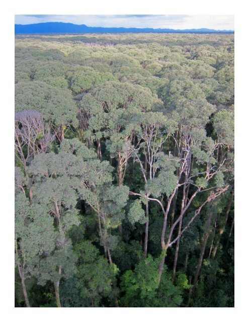
Fig. 2. Site of field data collection in Brunei Daruss<strong>al</strong>am. a, Distribution of<br />
peatlands in Borneo, Sumatra and Peninsular M<strong>al</strong>aysia. b, Field site in Brunei<br />
Daruss<strong>al</strong>am, on Borneo island. c, Contour map of study area from airborne LiDAR<br />
data, showing radiocarbon-dated peat cores (points) at primary site (Mendaram,<br />
south) and degraded site (Damit, north), and the boundaries of the flow tube used<br />
for hydrologic simulations (blue). d, Piezom<strong>et</strong>ers (triangles) at the Mendaram site. e,<br />
Survey points in microtopography transect (see Fig. 3b).<br />
increasingly sophisticated models for veg<strong>et</strong>ation dynamics and<br />
peat accumulation at a point. The most recent of these point<br />
models computes water table depth from monthly rainf<strong>al</strong>l<br />
using a site-specific model (16). Meanwhile, numeric<strong>al</strong> models<br />
have been used to simulate peat accumulation under constant<br />
rainf<strong>al</strong>l (17, 18). Although these subsequent works simulate the<br />
dynamics of peat production and decomposition in increasing<br />
d<strong>et</strong>ail, a strength of Ingram’s model was that it provided<br />
quantitative intuition for how peat dome morphology depends<br />
on peat hydrologic properties and average rainf<strong>al</strong>l. Could a<br />
principle like Ingram’s exist that describes peatland dynamics<br />
as well as statics, and remains applicable with re<strong>al</strong>istic drainage<br />
n<strong>et</strong>works and rainf<strong>al</strong>l regimes?<br />
We established a field site in one of the last pristine peat<br />
swamp forests in Southeast Asia, then used measurements<br />
from this site to develop a new mathematic<strong>al</strong> model for the<br />
geomorphic evolution of tropic<strong>al</strong> peatlands that is simpler, y<strong>et</strong><br />
more gener<strong>al</strong> than Ingram’s model for high-latitude peatlands.<br />
Our model makes it possible to predict e ects of changes in<br />
rainf<strong>al</strong>l regime and drainage n<strong>et</strong>works on carbon storage and<br />
fluxes in tropic<strong>al</strong> peatlands. The model predicted, perhaps<br />
surprisingly, that surface peat would be older near dome margins.<br />
We tested these predictions by radiocarbon-dating core<br />
samples and comparing the age of each sample to the simulated<br />
age at its location and depth. Fin<strong>al</strong>ly, we explored the future<br />
of tropic<strong>al</strong> peatlands under climate projections by simulating<br />
the geomorphic evolution of an ide<strong>al</strong>ized peat dome under<br />
projected changes in rainf<strong>al</strong>l patterns and drainage.<br />
187<br />
188<br />
189<br />
190<br />
191<br />
192<br />
193<br />
194<br />
195<br />
196<br />
197<br />
198<br />
199<br />
200<br />
201<br />
202<br />
203<br />
204<br />
205<br />
206<br />
207<br />
208<br />
209<br />
210<br />
211<br />
212<br />
213<br />
214<br />
215<br />
216<br />
217<br />
218<br />
219<br />
220<br />
221<br />
222<br />
223<br />
224<br />
225<br />
226<br />
227<br />
228<br />
229<br />
230<br />
231<br />
232<br />
233<br />
234<br />
235<br />
236<br />
237<br />
238<br />
239<br />
240<br />
241<br />
242<br />
243<br />
244<br />
245<br />
246<br />
247<br />
248<br />
2 | www.pnas.org/cgi/doi/10.1073/pnas.XXXXXXXXXX<br />
<strong>Cobb</strong> <strong>et</strong> <strong>al</strong>.
249<br />
250<br />
251<br />
252<br />
253<br />
254<br />
255<br />
256<br />
257<br />
258<br />
259<br />
260<br />
261<br />
262<br />
263<br />
264<br />
265<br />
266<br />
267<br />
268<br />
269<br />
270<br />
271<br />
272<br />
273<br />
274<br />
275<br />
276<br />
277<br />
278<br />
279<br />
280<br />
281<br />
282<br />
283<br />
284<br />
285<br />
286<br />
287<br />
288<br />
289<br />
290<br />
291<br />
292<br />
293<br />
294<br />
295<br />
296<br />
297<br />
298<br />
299<br />
300<br />
301<br />
302<br />
303<br />
304<br />
305<br />
306<br />
307<br />
308<br />
309<br />
310<br />
a<br />
Elevation, m a.s.l.<br />
8 decay<br />
6<br />
4<br />
2<br />
litter<br />
peat<br />
b 5.50<br />
Elevation, m a.s.l.<br />
5.25<br />
5.00<br />
pool<br />
0 50 100 150<br />
Position <strong>al</strong>ong transect, m<br />
DRAFT<br />
Height above<br />
land surface, cm<br />
20 c<br />
0<br />
-20<br />
2012-09 2012-10<br />
Fig. 3. Microtopography and water table dynamics in a tropic<strong>al</strong> peatland. a, Cartoon of tropic<strong>al</strong> peat cross-section showing variables: ˜p, the peat surface; p, the “land<br />
surface,” a smooth surface fit through loc<strong>al</strong> minima in ˜p; H, water table elevation; ’, water table height relative to the land surface, ’ = H ≠ p. The peat surface ˜p is irregular<br />
on a spati<strong>al</strong> sc<strong>al</strong>e of m<strong>et</strong>ers, with higher areas (hummocks) separating loc<strong>al</strong> depressions (hollows) that are not connected into channels. b, Tot<strong>al</strong> station survey of peat elevation<br />
˜p (black circles) <strong>al</strong>ong a transect, and the land surface p (dashed black line). The minimum, median, and maximum water table elevation H from each of 12 piezom<strong>et</strong>ers <strong>al</strong>ong<br />
the transect are <strong>al</strong>so shown (dashed blue lines). The absolute elevation of the survey points comes from matching loc<strong>al</strong> minima among survey points within 20 m x 20 m squares<br />
(white diamonds) with loc<strong>al</strong> minima in LiDAR last r<strong>et</strong>urn data within the same squares (red diamonds). The land surface p is represented by the dashed horizont<strong>al</strong> black line. c,<br />
Water table dynamics <strong>al</strong>ong survey transect (d) in late 2012, relative to the land surface p. What appears to be a single blue line is superimposed data from the 12 piezom<strong>et</strong>ers<br />
shown in (d). Also shown are the average minimum, median, and maximum water table elevation above the land surface during the same time period for <strong>al</strong>l 12 piezom<strong>et</strong>ers.<br />
M<strong>et</strong>hods Summary<br />
Field measurements. We established a field site in pristine<br />
peat forest in Brunei Daruss<strong>al</strong>am (Borneo) to study a peat<br />
dome where current processes a ecting peat accumulation<br />
are essenti<strong>al</strong>ly similar to those during its long-term development<br />
(Fig. 2). At the site, we inst<strong>al</strong>led 5 piezom<strong>et</strong>ers <strong>al</strong>ong<br />
a 2.5 km trail, 12 piezom<strong>et</strong>ers <strong>al</strong>ong a 180 m transect, and 3<br />
throughf<strong>al</strong>l gauges. We compl<strong>et</strong>ed a tot<strong>al</strong> station survey of<br />
peat surface elevation <strong>al</strong>ong the transect to characterize peat<br />
surface microtopography. To characterize large-sc<strong>al</strong>e peatland<br />
morphology, we <strong>al</strong>so obtained LiDAR data for the entire study<br />
area. To study peat dome development, we collected 9 peat<br />
cores from which we obtained 37 radiocarbon dates. To test<br />
wh<strong>et</strong>her our undisturbed site behaved similarly to sites studied<br />
by other groups, we inst<strong>al</strong>led 4 soil respiration chambers and<br />
a piezom<strong>et</strong>er at a nearby logged but undrained site.<br />
Morphology vs. microtopography. Superimposed on the gross<br />
morphology of a peat dome is a fine microtopography of m<strong>et</strong>ersc<strong>al</strong>e<br />
depressions, or hollows, separated by higher areas, or<br />
hummocks (19, 20). The hummocks consist of partly decomposed<br />
logs, branches, and leaves lodged among living<br />
buttresses, stilt roots, pneumatophores, and giant rhizomes.<br />
Whereas the microtopography in high-latitude peat bogs may<br />
have regular and oriented patterns (21), surveys by Lampela<br />
<strong>et</strong> <strong>al</strong>. (20) in a tropic<strong>al</strong> peat swamp in Centr<strong>al</strong> K<strong>al</strong>imantan<br />
showed no orientation or regularity. Similarly, our microtopography<br />
survey and other observations reve<strong>al</strong>ed no regular<br />
patterns or channels in peat dome microtopography.<br />
In describing the evolution of peat dome morphology, we<br />
would like to capture the e ects of the hummock-and-hollow<br />
microtopography without explicitly simulating its d<strong>et</strong>ails. Measurements<br />
from the 12 piezom<strong>et</strong>ers <strong>al</strong>ong our microtopography<br />
transect showed that the water table is relatively smooth, even<br />
though the peat surface is highly irregular on a spati<strong>al</strong> sc<strong>al</strong>e<br />
of centim<strong>et</strong>ers to m<strong>et</strong>ers (Fig. 3). We therefore represent the<br />
peat surface by a reference surface p, smooth like the water<br />
table, that underlies the actu<strong>al</strong> peat surface ˜p. We refer to<br />
this reference surface p as the “land surface.” The peat surface<br />
˜p is a “texture” that sits on the smooth land surface p. The<br />
bottoms of hollows provide the most readily identifiable loc<strong>al</strong><br />
reference elevation (20), so we define the land surface p as a<br />
smooth surface fit through the bottoms of hollows (loc<strong>al</strong> minima<br />
in the peat surface ˜p). On the basis of this definition, we<br />
d<strong>et</strong>ermined the current land surface at our site by smoothing a<br />
raster map obtained from loc<strong>al</strong> minima in LiDAR last-r<strong>et</strong>urn<br />
points. We <strong>al</strong>so used the transect survey and piezom<strong>et</strong>er data<br />
to find the land surface p <strong>al</strong>ong the microtopography survey<br />
transect (SI Text).<br />
Groundwater flow. We model the dynamics of the water table<br />
H subject to n<strong>et</strong> precipitation q n (rainf<strong>al</strong>l intensity R minus<br />
evapotranspiration ET) using Boussinesq’s equation for<br />
essenti<strong>al</strong>ly horizont<strong>al</strong> groundwater flow<br />
ˆH<br />
S y = qn + Ò · (T ÒH) [1]<br />
ˆt<br />
where the specific yield S y is the amount of water required<br />
for a di erenti<strong>al</strong> increment in water table elevation, and transmissivity<br />
T is the volum<strong>et</strong>ric flow per perim<strong>et</strong>er driven by<br />
a particular head gradient ÒH. Boussinesq’s equation is a<br />
standard groundwater modeling equation for flow domains like<br />
peatlands that are much wider than they are thick.<br />
At high water tables, hollows become flooded from saturation<br />
of the peat below, forming sm<strong>al</strong>l pools. These pools<br />
are not connected into channels (20), and therefore do not<br />
<strong>al</strong>low open-channel flow on a large sc<strong>al</strong>e in the peatland. Instead,<br />
flow through the peatland is limited by flow through<br />
the porous matrix of the hummocks b<strong>et</strong>ween these isolated<br />
pools. We apply Boussinesq’s equation at sc<strong>al</strong>es much larger<br />
than hummocks and hollows (tens of m<strong>et</strong>ers) and refer to<br />
the flow of water through the peatland as “groundwater flow”<br />
even though some flow occurs above the loc<strong>al</strong> peat surface, in<br />
hollows, during w<strong>et</strong> periods. Boussinesq’s equation requires<br />
only that later<strong>al</strong> flow is proportion<strong>al</strong> to the head gradient,<br />
which is the case if the over<strong>al</strong>l flow is limited by laminar flow<br />
through hummocks. We never observed ephemer<strong>al</strong> channels<br />
connecting hollows within the peatland in our six years at the<br />
site. In addition, if flow were non-laminar, we would expect<br />
di erent loc<strong>al</strong> flow behavior at the same water table height in<br />
areas with di erent water table gradients, but instead water<br />
table behavior is uniform (Results and Discussion).<br />
Loc<strong>al</strong> carbon b<strong>al</strong>ance. A broad range of studies demonstrates<br />
that the thickness of peat exposed above the water table d<strong>et</strong>ermines<br />
the rate of peat accumulation or loss (4, 22). Like<br />
others (4, 22), we modeled the dynamics of peat accumulation<br />
311<br />
312<br />
313<br />
314<br />
315<br />
316<br />
317<br />
318<br />
319<br />
320<br />
321<br />
322<br />
323<br />
324<br />
325<br />
326<br />
327<br />
328<br />
329<br />
330<br />
331<br />
332<br />
333<br />
334<br />
335<br />
336<br />
337<br />
338<br />
339<br />
340<br />
341<br />
342<br />
343<br />
344<br />
345<br />
346<br />
347<br />
348<br />
349<br />
350<br />
351<br />
352<br />
353<br />
354<br />
355<br />
356<br />
357<br />
358<br />
359<br />
360<br />
361<br />
362<br />
363<br />
364<br />
365<br />
366<br />
367<br />
368<br />
369<br />
370<br />
371<br />
372<br />
<strong>Cobb</strong><br />
<strong>et</strong> <strong>al</strong>.<br />
PNAS | April 13, 2017 | vol. XXX | no. XX | 3
373<br />
374<br />
375<br />
376<br />
377<br />
378<br />
379<br />
380<br />
381<br />
382<br />
383<br />
384<br />
385<br />
386<br />
387<br />
388<br />
389<br />
390<br />
391<br />
392<br />
393<br />
394<br />
395<br />
396<br />
397<br />
398<br />
399<br />
400<br />
401<br />
402<br />
403<br />
404<br />
405<br />
406<br />
407<br />
408<br />
409<br />
410<br />
411<br />
412<br />
413<br />
414<br />
415<br />
416<br />
417<br />
418<br />
419<br />
420<br />
421<br />
422<br />
423<br />
424<br />
425<br />
426<br />
427<br />
428<br />
429<br />
430<br />
431<br />
432<br />
433<br />
434<br />
Water table height , cm<br />
a 20<br />
0<br />
−20<br />
−40<br />
−60<br />
−80<br />
Land surface p<br />
(bottoms of hollows)<br />
−6 −4 −2 0<br />
Peat accumulation (+)<br />
or loss (−) , cm / y<br />
b<br />
0 2 4<br />
Soil surface CO 2 flux,<br />
µmol m -2 s -1<br />
Fig. 4. Peat accumulation and CO 2 flux vs. water table height in tropic<strong>al</strong> peatlands.<br />
Peat accumulation (a) represents the b<strong>al</strong>ance b<strong>et</strong>ween peat production and<br />
decomposition. Aerobic decomposition is one of the two main sources of peat surface<br />
CO 2 flux (b); the other is root respiration. a, Peat accumulation or loss vs. water<br />
table height from model c<strong>al</strong>ibration (solid line) and from literature subsidence data<br />
(circles: (4); squares: (22)). The straight line was not fit to these data, but rather, arose<br />
natur<strong>al</strong>ly from c<strong>al</strong>ibration to match the modern surface of the Mendaram peat dome<br />
(Figure 7). b, Soil surface CO 2 flux vs. water table height at our site in Brunei Daruss<strong>al</strong>am<br />
(white circles) was very similar to fluxes in other tropic<strong>al</strong> peatlands (squares<br />
(23), diamonds (19), triangles (24); pentagons (9); hexagons (25)).<br />
or loss ˆp/ˆt as the di erence b<strong>et</strong>ween the rate of peat production<br />
f p when the water table is at the land surface, and<br />
the rate of peat loss by decomposition (p ≠ H)–, which is the<br />
thickness p ≠ H of peat exposed above the water table times<br />
a decomposition rate constant –<br />
ˆp<br />
= fp ≠ (p ≠ H)– [2]<br />
ˆt<br />
(Fig. 4). The peat surface is stable, neither growing nor<br />
subsiding Ȉp/ˆtÍ =0wherever the water table fluctuates in<br />
such a way that peat production is b<strong>al</strong>anced by decomposition<br />
over time<br />
f p = Èp ≠ HÍ –, [3]<br />
where angle brack<strong>et</strong>s È·Í indicate a time average.<br />
Sever<strong>al</strong> other studies have shown a leveling-o of soil CO 2<br />
e ux at very low water tables (25, 26), and it is <strong>al</strong>so likely<br />
that very high water tables ultimately limit n<strong>et</strong> carbon uptake<br />
by trees (primary production) (16). However, including these<br />
e ects did not a ect simulations because these extreme water<br />
table heights and depths were neither observed at our site<br />
nor predicted by simulations of our site. We <strong>al</strong>so did not<br />
include anaerobic decomposition below the water table because<br />
an<strong>al</strong>ysis of peat cores from tropic<strong>al</strong> sites in Asia (2), including<br />
our site (27), do not show d<strong>et</strong>ectable loss of waterlogged peat<br />
from anaerobic decomposition.<br />
Numeric<strong>al</strong> simulations. We built a numeric<strong>al</strong> model of waterlogging<br />
and peat accumulation based on Eqn. 1 and Eqn. 2<br />
to simulate peat dome geomorphogenesis and carbon fluxes.<br />
These two equations are coupled by the water table elevation<br />
H and the peat surface elevation p, both of which vary in<br />
time and space. The equations require four param<strong>et</strong>ers: (1)<br />
a specific yield function S y, (2) a transmissivity function T ,<br />
(3) a rate of peat production f p, and (4) a decomposition rate<br />
constant –. The model employs a finite volume scheme with<br />
speci<strong>al</strong> features designed to handle the severe nonlinearity of<br />
the transmissivity function T (SI Text).<br />
We d<strong>et</strong>ermined the specific yield and transmissivity functions<br />
S y,T from the response of the water table to heavy<br />
rain and dry spells (Results and Discussion). We then fit<br />
the param<strong>et</strong>ers for peat accumulation f p, – by simulating the<br />
2700-year evolution of a peat dome at our field site in Brunei,<br />
and matching the simulated modern peat surface to the peat<br />
surface measured by LiDAR. We tested our model against radiocarbon<br />
dates from peat cores extracted from the peatland,<br />
then used the model to answer gener<strong>al</strong> questions about carbon<br />
fluxes from tropic<strong>al</strong> peatlands after perturbation by climate<br />
change and drainage.<br />
Limitations of modeling approach. Our go<strong>al</strong> was to build the<br />
simplest model that can make reasonable quantitative predictions<br />
of tropic<strong>al</strong> peat dome dynamics. In most Southeast Asian<br />
peatland complexes, every area b<strong>et</strong>ween rivers is occupied by a<br />
peat dome, so it is not apparent how any peat dome could now<br />
expand to fill a larger area. However, domes tend to be larger<br />
in older peatlands, suggesting a long-term process of dome<br />
co<strong>al</strong>escence. We did not attempt to model these long-term<br />
changes in river n<strong>et</strong>works. We <strong>al</strong>so did not consider changes in<br />
hydraulic conductivity near the surface caused by compaction<br />
or changes in microtopography under agriculture.<br />
Results and Discussion<br />
Carbon storage capacity of tropic<strong>al</strong> peatlands.<br />
Loc<strong>al</strong> water b<strong>al</strong>ance is dominated by flows near the surface. Eighteen<br />
months of data on water table height in five piezom<strong>et</strong>ers<br />
<strong>al</strong>ong a 2.5 km transect (Fig. 5) show two distinctive features<br />
of water table behavior in tropic<strong>al</strong> peatlands. First, when the<br />
water table is high, it f<strong>al</strong>ls very rapidly; and second, the water<br />
table height relative to the land surface remains approximately<br />
uniform in <strong>al</strong>l piezom<strong>et</strong>ers as the water table rises and f<strong>al</strong>ls,<br />
as observed elsewhere by Hooijer (28). In what follows, we<br />
use “water table height” ’ = H ≠ p to refer to the water<br />
table height relative to the land surface, as distinct from the<br />
water table elevation H above mean sea level. Because the<br />
water table height ’ is approximately uniform, the water table<br />
behavior can be summarized by a pair of curves describing<br />
the uniform rise of the water table during heavy rain, and<br />
the uniform decline of the water table during dry interv<strong>al</strong>s<br />
b<strong>et</strong>ween rains (Fig. 5e,f). During heavy rain, the e ects of<br />
evapotranspiration and outward flow are negligible, and the<br />
rainf<strong>al</strong>l intensity vs. rate of increase in water table height<br />
gives the specific yield. B<strong>et</strong>ween rain events, the water table<br />
DRAFT<br />
declines because of evapotranspiration and the divergence of<br />
groundwater flow.<br />
Transmissivity T is a function of water table height ’ and<br />
controls the divergence of groundwater flow Ò · (T ÒH). We<br />
d<strong>et</strong>ermined the e ect of water table height on transmissivity<br />
using our water table data. The water table declines during<br />
dry interv<strong>al</strong>s because of a combination of evapotranspiration<br />
and the divergence of groundwater flow; however, the two are<br />
easily distinguished at low water tables because evapotranspiration<br />
ceases at night (Fig. 5d). Therefore, we can obtain<br />
the divergence of groundwater flow from the declining water<br />
table during dry interv<strong>al</strong>s after accounting for evapotranspiration<br />
((28, 29); further d<strong>et</strong>ails in SI Text). We find that<br />
transmissivity increases exponenti<strong>al</strong>ly at high water tables,<br />
when water rises into hollows and flows through hummocks,<br />
but decreases dramatic<strong>al</strong>ly at low water tables when water<br />
flows through fine pores in the peat matrix (Fig. 5c). Very<br />
high permeability near the peat surface is consistent with our<br />
observations of more void space higher in the peat profile, and<br />
435<br />
436<br />
437<br />
438<br />
439<br />
440<br />
441<br />
442<br />
443<br />
444<br />
445<br />
446<br />
447<br />
448<br />
449<br />
450<br />
451<br />
452<br />
453<br />
454<br />
455<br />
456<br />
457<br />
458<br />
459<br />
460<br />
461<br />
462<br />
463<br />
464<br />
465<br />
466<br />
467<br />
468<br />
469<br />
470<br />
471<br />
472<br />
473<br />
474<br />
475<br />
476<br />
477<br />
478<br />
479<br />
480<br />
481<br />
482<br />
483<br />
484<br />
485<br />
486<br />
487<br />
488<br />
489<br />
490<br />
491<br />
492<br />
493<br />
494<br />
495<br />
496<br />
4 | www.pnas.org/cgi/doi/10.1073/pnas.XXXXXXXXXX<br />
<strong>Cobb</strong> <strong>et</strong> <strong>al</strong>.
497<br />
498<br />
499<br />
500<br />
501<br />
502<br />
503<br />
504<br />
505<br />
506<br />
507<br />
508<br />
509<br />
510<br />
511<br />
512<br />
513<br />
514<br />
515<br />
516<br />
517<br />
518<br />
519<br />
520<br />
521<br />
522<br />
523<br />
524<br />
525<br />
526<br />
527<br />
528<br />
529<br />
530<br />
531<br />
532<br />
533<br />
534<br />
535<br />
536<br />
537<br />
538<br />
539<br />
540<br />
541<br />
542<br />
543<br />
544<br />
545<br />
546<br />
547<br />
548<br />
549<br />
550<br />
551<br />
552<br />
553<br />
554<br />
555<br />
556<br />
557<br />
558<br />
Water table height , cm<br />
Water table height , cm<br />
20<br />
0<br />
−20<br />
20<br />
0<br />
−20<br />
a<br />
(Maximum loc<strong>al</strong> peat surface height in transect)<br />
2012-02 2012-04 2012-06 2012-08 2012-10 2012-12<br />
d<br />
Heavy rain<br />
Time<br />
No rain<br />
e<br />
Heavy rain<br />
0 10<br />
Rainf<strong>al</strong>l depth P, cm<br />
f Bog plain<br />
piezom<strong>et</strong>er<br />
Rainf<strong>al</strong>l intensity R, cm / h<br />
DRAFT<br />
10<br />
5<br />
0<br />
Water table height , cm<br />
20<br />
−20<br />
b<br />
0 0.25 0.5 10 2 10 4<br />
Specific yield S y ,<br />
cm / cm<br />
Transmissivity T,<br />
m 2 d -1<br />
No rain<br />
0 10 20 30<br />
Time since rain stopped, d<br />
Fig. 5. Site hydrology and c<strong>al</strong>ibration. a, Superimposed water table height (jagged blue lines) from five piezom<strong>et</strong>ers spanning 2.5 km and rainf<strong>al</strong>l intensity (vertic<strong>al</strong> lines)<br />
from three automated rain gauges over a 10-month interv<strong>al</strong>. The piezom<strong>et</strong>er farthest from the river (red) lies in a region with a different surface Laplacian (the “bog plain”),<br />
corresponding to an area of current peat accumulation (Fig. 6). Also shown are the minimum, median, and maximum loc<strong>al</strong> peat surface elevation (dashed horizont<strong>al</strong> lines) from<br />
a 180 m microtopography survey transect (Fig. 3). b, c, Hillslope-sc<strong>al</strong>e specific yield and transmissivity curves for field site, d<strong>et</strong>ermined from recharge and recession curves (e,<br />
f). d, Short interv<strong>al</strong> of water table data from a single piezom<strong>et</strong>er selected from (a). Ins<strong>et</strong> shows declining water tables during day (unshaded) and steady water tables at night<br />
(shaded) driven by diurn<strong>al</strong> cycles of evapotranspiration. e, f, Master recharge curve (e) and recession curve (f) assembled from interv<strong>al</strong>s of heavy rain and no rain, respectively,<br />
by <strong>al</strong>ignment of sequences with overlapping water table depth. During heavy rain, n<strong>et</strong> precipitation intensity q n = R ≠ ET is dominated by rainf<strong>al</strong>l intensity R (e); with no rain,<br />
n<strong>et</strong> precipitation consists only of evapotranspiration ET (f). Dashed black lines in (e) and (f) show water table response computed from specific yield and transmissivity (b,c),<br />
blue translucent lines are assembled from field data in (a). As in (a), the red curve is from the piezom<strong>et</strong>er in the flatter bog plain region (Fig. 6).<br />
<strong>al</strong>so with recent data from other tropic<strong>al</strong> peatlands (30). The<br />
water table curves (Fig. 5e,f) indicate that the near-surface<br />
permeability is so great that the tot<strong>al</strong> thickness of deeper peat<br />
is unimportant for groundwater flow. Therefore, transmissivity<br />
is approximately independent of peat depth, and depends only<br />
on the water table height ’, which is uniform in space (though<br />
highly variable in time).<br />
Morphology of peat surface explains uniform water table behavior.<br />
According to Boussinesq’s equation, uniform transmissivity<br />
is not, by itself, enough to explain the uniform fluctuation of<br />
the water table. Even in hydrologic systems where hydraulic<br />
properties are uniform, the water table can behave di erently<br />
at di erent locations because of topography. For example, in<br />
most hydrologic systems a rainstorm drives a di erent water<br />
table response at a topographic divide than it does near where<br />
groundwater discharges to a river.<br />
To understand the uniform water table behavior in peatlands,<br />
we refer back to Boussinesq’s equation (Eqn. 1). If both<br />
the specific yield S y and the transmissivity T depend only on<br />
the loc<strong>al</strong> water table height relative to the surface and not on<br />
position within the peatland, uniform water table movement<br />
occurs if the divergence of the peat surface gradient, or the<br />
peat surface Laplacian Ò 2 p, is uniform (Fig. S4c–e). (The<br />
“Laplacian of the peat surface” Ò 2 p, or just “Laplacian,” is<br />
the sc<strong>al</strong>ar result of applying the Laplacian operator Ò 2 to the<br />
land surface elevation p.) To see why a uniform land surface<br />
Laplacian explains uniform water table behavior, we re-write<br />
Boussinesq’s equation (Eqn. 1) in terms of the water table<br />
height relative to the land surface (’ = H ≠ p), instead of the<br />
water table elevation H:<br />
S y<br />
ˆ(p + ’)<br />
ˆt<br />
= q n + Ò · [T Ò(p + ’)] . [4]<br />
0<br />
We observe that water table height is uniform (Ò’ = 0). If<br />
transmissivity T is <strong>al</strong>so spati<strong>al</strong>ly uniform, the groundwater<br />
divergence term simplifies to the transmissivity times the<br />
peat surface Laplacian (Ò · [T Ò(p + ’)] = T Ò 2 p). The time<br />
derivative ˆp/ˆt of the land surface elevation is negligible<br />
because peat accumulation or loss is much slower than rise<br />
or f<strong>al</strong>l of the water table, so the term p can be dropped from<br />
the time derivative. We observe that the fluctuations in water<br />
table height ˆ’/ˆt are uniform, as is n<strong>et</strong> precipitation q n,so<br />
the groundwater divergence term T Ò 2 p must <strong>al</strong>so be spati<strong>al</strong>ly<br />
uniform. Thus, Boussinesq’s equation simplifies to an ordinary<br />
di erenti<strong>al</strong> equation (ODE) describing the uniform fluctuation<br />
of the water table relative to the peat surface<br />
S y<br />
d’<br />
dt = qn + T Ò2 p [5]<br />
where the peat surface Laplacian Ò 2 p is uniform.<br />
The peat surface Laplacian describes the curvature of the<br />
peat surface: it is equ<strong>al</strong> to the sum of the second derivatives of<br />
the surface elevation in two perpendicular horizont<strong>al</strong> directions<br />
(Ò 2 p = ˆ2p/ˆx 2 + ˆ2p/ˆy 2 ). Thus, an<strong>al</strong>ysis of water table<br />
dynamics predicts uniform curvature of the peat surface where<br />
water table fluctuations are uniform. This uniformity of surface<br />
elevation curvature can be tested against elevation maps.<br />
Maps of the peat surface Laplacian are highly sensitive to<br />
microtopographic noise in the surface elevation map because<br />
the Laplacian uses the second derivative of the surface elevation.<br />
However, by the Divergence Theorem, the average<br />
Laplacian within any closed contour is equ<strong>al</strong> to the integr<strong>al</strong> of<br />
the norm<strong>al</strong> gradient <strong>al</strong>ong the contour divided by the enclosed<br />
area. Therefore, we can examine the uniformity of the surface<br />
Laplacian by studying the slope of a regression b<strong>et</strong>ween the<br />
c<br />
559<br />
560<br />
561<br />
562<br />
563<br />
564<br />
565<br />
566<br />
567<br />
568<br />
569<br />
570<br />
571<br />
572<br />
573<br />
574<br />
575<br />
576<br />
577<br />
578<br />
579<br />
580<br />
581<br />
582<br />
583<br />
584<br />
585<br />
586<br />
587<br />
588<br />
589<br />
590<br />
591<br />
592<br />
593<br />
594<br />
595<br />
596<br />
597<br />
598<br />
599<br />
600<br />
601<br />
602<br />
603<br />
604<br />
605<br />
606<br />
607<br />
608<br />
609<br />
610<br />
611<br />
612<br />
613<br />
614<br />
615<br />
616<br />
617<br />
618<br />
619<br />
620<br />
<strong>Cobb</strong><br />
<strong>et</strong> <strong>al</strong>.<br />
PNAS | April 13, 2017 | vol. XXX | no. XX | 5
621<br />
622<br />
623<br />
624<br />
625<br />
626<br />
627<br />
628<br />
629<br />
630<br />
631<br />
632<br />
633<br />
634<br />
635<br />
636<br />
637<br />
638<br />
639<br />
640<br />
641<br />
642<br />
643<br />
644<br />
645<br />
646<br />
647<br />
648<br />
649<br />
650<br />
651<br />
652<br />
653<br />
654<br />
655<br />
656<br />
657<br />
658<br />
659<br />
660<br />
661<br />
662<br />
663<br />
664<br />
665<br />
666<br />
667<br />
668<br />
669<br />
670<br />
671<br />
672<br />
673<br />
674<br />
675<br />
676<br />
677<br />
678<br />
679<br />
680<br />
681<br />
682<br />
b<br />
Land surface<br />
elevation p, m<br />
c<br />
Integrated<br />
norm<strong>al</strong> gradient, m<br />
a<br />
6<br />
4<br />
2<br />
4<br />
Bog plain<br />
piezom<strong>et</strong>er<br />
Bog plain<br />
Bog plain<br />
Bog plain piezom<strong>et</strong>er<br />
Bog plain<br />
2 0<br />
Distance from river, km<br />
Enclosed area, km 2<br />
Stable<br />
Stable<br />
(uniform surface<br />
Laplacian)<br />
Stable<br />
River flooding<br />
influence<br />
River<br />
flooding<br />
influence<br />
River flooding<br />
influence<br />
Fig. 6. Estimation of peat surface Laplacian. a, Regions of different morphology<br />
and water table behavior within the flow tube used for field site simulations, and<br />
locations of piezom<strong>et</strong>ers (triangles). Furthest from the river, the land surface is<br />
relatively flat (“bog plain”), next there is a region in which the Laplacian of the land<br />
surface elevation is uniform (“stable”) and fin<strong>al</strong>ly a narrow region near the river where<br />
hydrologic processes and peat accumulation are affected by the rise and f<strong>al</strong>l of the<br />
bounding river (“river flooding influence”). b, Profile of LiDAR land surface elevation<br />
from (a), showing piezom<strong>et</strong>er locations (vertic<strong>al</strong> dashed lines). c, Norm<strong>al</strong> gradient<br />
driving efflux, integrated <strong>al</strong>ong contours, vs. enclosed area. The slope in the “stable”<br />
region gives the average land surface Laplacian of the land surface there and was<br />
used for c<strong>al</strong>ibration of hydrologic param<strong>et</strong>ers.<br />
integrated norm<strong>al</strong> gradient and the enclosed area (Fig. 6).<br />
Indeed, we find a linear relationship b<strong>et</strong>ween the integrated<br />
norm<strong>al</strong> gradient <strong>al</strong>ong each contour and the area enclosed by<br />
the contour in our LiDAR-derived peat surface elevation map,<br />
indicating a uniform surface Laplacian in the region of uniform<br />
water table behavior (Fig. 6). In contrast, outside the region<br />
of uniform Laplacian, the water table behaves di erently (‘bog<br />
plain piezom<strong>et</strong>er’ in Figs. 5,6).<br />
Uniform surface Laplacian d<strong>et</strong>ermines stable tropic<strong>al</strong> peatland morphology.<br />
The uniform peat surface Laplacian provides a remarkably<br />
simple way to compute a stable morphology for a tropic<strong>al</strong><br />
peat dome. By “stable morphology,” we mean a morphology<br />
in which the peat surface and water table continue to fluctuate<br />
with the vagaries of climate, but there is no long-term average<br />
change in the peat surface or water table elevation (they are<br />
stationary; Ȉp/ˆtÍ =0, ȈH/ˆtÍ =0). Uniform water table<br />
height is the simplest behavior that could make an entire<br />
peatland stable, because if the water table height is spati<strong>al</strong>ly<br />
uniform, the loc<strong>al</strong> rate of peat accumulation is <strong>al</strong>so uniform.<br />
In a stable peatland, there is no long-term change in the water<br />
table height, so any water added by n<strong>et</strong> precipitation must<br />
eventu<strong>al</strong>ly be removed by groundwater flow<br />
e f<br />
d’<br />
0= S y = Èq nÍ + ÈT ÍÒ 2 p Œ. [6]<br />
dt<br />
Thus the Laplacian Ò 2 p Œ of the stable peatland surface p Œ<br />
is minus the average n<strong>et</strong> precipitation divided by the average<br />
transmissivity<br />
Ò 2 p Œ = ≠ ÈqnÍ<br />
ÈT Í . [7]<br />
We can compute the stable topography of any tropic<strong>al</strong><br />
peatland by solving Poisson’s equation (Eqn. 7) for the stable<br />
peat surface morphology p Πusing the appropriate Laplacian<br />
v<strong>al</strong>ue for that climate. The average transmissivity ÈT Í is a<br />
complicated function of the tempor<strong>al</strong> pattern of rainf<strong>al</strong>l and<br />
the hydrologic-biologic<strong>al</strong> system. However, for any rainf<strong>al</strong>l<br />
regime, one can find the stable surface Laplacian Ò 2 p Œ by<br />
repeatedly simulating water table fluctuations (Eqn. 5) with a<br />
tri<strong>al</strong> Laplacian Ò 2 p, and adjusting the Laplacian v<strong>al</strong>ue until<br />
peat production b<strong>al</strong>ances decomposition (Eqn. 3) everywhere<br />
in the peatland (SI Text). In this way, one finds a shape<br />
param<strong>et</strong>er (Ò 2 p Œ) that describes stable peatland morphology<br />
under a given rainf<strong>al</strong>l regime in any drainage n<strong>et</strong>work.<br />
Climate and drainage n<strong>et</strong>work d<strong>et</strong>ermine tropic<strong>al</strong> peatland carbon<br />
storage capacity. By specifying the stable peatland topography,<br />
the uniform Laplacian principle gives the peat carbon storage<br />
capacity inside any drainage boundary and in any given<br />
climate. The volume under the surface satisfying Poisson’s<br />
equation times the mean carbon density of the peat gives the<br />
carbon storage capacity of the peatland. For example, the<br />
peat dome at our primary site currently has a mean peat<br />
depth of 3.88 m (max 4.92), and stores about 1535 t C ha ≠1 ;<br />
however, if the climate remains similar to the climate during<br />
its 2300-year development, we predict that in about 2500 y it<br />
will reach a stable shape with a mean peat depth of 4.54 m<br />
(max 7.10 m) and store 1800 t C ha ≠1 (Fig. S3; simulations of<br />
dynamics are described in the next section).<br />
The uniformity of the stable peat surface Laplacian is an<br />
approximation that requires that (1) peat accumulation rate<br />
ˆp/ˆt is a non-decreasing function of water table height; (2)<br />
flow of water is proportion<strong>al</strong> to water table gradient (Boussinesq’s<br />
equation); and (3) transmissivity is independent of location<br />
because flow through deep peat is negligible compared to<br />
DRAFT<br />
near-surface flow. In re<strong>al</strong>ity, groundwater flow through deeper<br />
peat will result in a deviation of the stable peat dome surface<br />
from the uniform Laplacian shape in very large peat domes.<br />
Specific<strong>al</strong>ly, groundwater flow through deep, low-permeability<br />
peat will tend to flatten the dome center, because of slow<br />
infiltration of water into the deep peat, and steepen the dome<br />
margin, because of exfiltration of water back into the high permeability<br />
near-surface peat near the boundary. Deep groundwater<br />
flow should be manifested as a downward (dome center)<br />
or upward (dome margin) trend in the water table during<br />
nights without rain when the water table is low; no such trend<br />
is apparent in our piezom<strong>et</strong>er data (Fig. 5d), suggesting that<br />
deep groundwater flow is sm<strong>al</strong>l. A sm<strong>al</strong>l deep groundwater flow<br />
term is further supported by radiocarbon dating of porewater<br />
DOC at our site (31), which suggests a maximum downward<br />
velocity of water of about one m<strong>et</strong>er per year, or at most a<br />
1.4 mm water table decline during a single twelve-hour night,<br />
one-sixteenth of the 22 mm water table decline from evapotranspiration<br />
during the day (Fig. 5). (Evapotranspirative<br />
683<br />
684<br />
685<br />
686<br />
687<br />
688<br />
689<br />
690<br />
691<br />
692<br />
693<br />
694<br />
695<br />
696<br />
697<br />
698<br />
699<br />
700<br />
701<br />
702<br />
703<br />
704<br />
705<br />
706<br />
707<br />
708<br />
709<br />
710<br />
711<br />
712<br />
713<br />
714<br />
715<br />
716<br />
717<br />
718<br />
719<br />
720<br />
721<br />
722<br />
723<br />
724<br />
725<br />
726<br />
727<br />
728<br />
729<br />
730<br />
731<br />
732<br />
733<br />
734<br />
735<br />
736<br />
737<br />
738<br />
739<br />
740<br />
741<br />
742<br />
743<br />
744<br />
6 | www.pnas.org/cgi/doi/10.1073/pnas.XXXXXXXXXX<br />
<strong>Cobb</strong> <strong>et</strong> <strong>al</strong>.
745<br />
746<br />
747<br />
748<br />
749<br />
750<br />
751<br />
752<br />
753<br />
754<br />
755<br />
756<br />
757<br />
758<br />
759<br />
760<br />
761<br />
762<br />
763<br />
764<br />
765<br />
766<br />
767<br />
768<br />
769<br />
770<br />
771<br />
772<br />
773<br />
774<br />
775<br />
776<br />
777<br />
778<br />
779<br />
780<br />
781<br />
782<br />
783<br />
784<br />
785<br />
786<br />
787<br />
788<br />
789<br />
790<br />
791<br />
792<br />
793<br />
794<br />
795<br />
796<br />
797<br />
798<br />
799<br />
800<br />
801<br />
802<br />
803<br />
804<br />
805<br />
806<br />
Land surface elevation p, m<br />
a<br />
b<br />
Simulated peat age,<br />
c<strong>al</strong> y BP × 1000<br />
6<br />
3<br />
0 Clay<br />
2<br />
1<br />
4<br />
0<br />
0<br />
1 2<br />
Peat sample age, c<strong>al</strong> y BP × 1000<br />
Modern peat surface (LiDAR)<br />
2 0<br />
Distance from river, km<br />
Age at 25–67 cm depth,<br />
c<strong>al</strong> y BP × 1000<br />
c<br />
1.0<br />
0.5<br />
0<br />
Simulated peat surface vs time<br />
Primary site<br />
Deforested site<br />
Radiocarbon-dated<br />
core sample<br />
River<br />
3 2 1 0<br />
Distance from river, km<br />
Fig. 7. Morphogenesis of Mendaram peat dome. a, Shape of peat dome over time,<br />
including modeled peat surface (contours), modern peat surface from LiDAR (dashed<br />
black line), and c<strong>al</strong>ibrated radiocarbon dates from peat core samples (colored points).<br />
The deepest peat layers prior to 2250 c<strong>al</strong> y BP represent a uniformly deposited<br />
mangrove peat on a gently sloping clay plain (27). b, Simulated age of peat vs.<br />
c<strong>al</strong>ibrated radiocarbon ages from samples in the Mendaram peat dome. c, Age of<br />
sh<strong>al</strong>low peat samples (25 cm–65 cm depth) vs. distance from river at primary site<br />
(solid markers) and a nearby deforested site (open markers). Note the old peat near<br />
the surface close to the river as predicted by the model.<br />
flux is about one-tenth of the rate of decline of the water table<br />
from evapotranspiration because about one tenth of the deep<br />
peat cross-section is available for water flow; see specific yield<br />
curve, Fig. 5b.)<br />
A shape param<strong>et</strong>er related to our stable peatland Laplacian<br />
(Eqn. 7) appeared in Ingram’s model for temperate peatland<br />
morphology (10) assuming constant precipitation, uniform<br />
hydraulic conductivity, and simple river geom<strong>et</strong>ry (Ingram’s<br />
param<strong>et</strong>er is n<strong>et</strong> precipitation divided by hydraulic conductivity,<br />
instead of average transmissivity). Our result is more<br />
gener<strong>al</strong>, because it handles varying rainf<strong>al</strong>l and arbitrary landscapes,<br />
but is <strong>al</strong>so mathematic<strong>al</strong>ly simpler, because of our<br />
finding that transmissivity in tropic<strong>al</strong> peatlands is approximately<br />
independent of peat depth.<br />
Dynamics of tropic<strong>al</strong> peatland topography and carbon fluxes.<br />
Peat accumulation param<strong>et</strong>ers regulate dome dynamics. Our an<strong>al</strong>ysis<br />
shows how the rate of peat production f p and decomposition<br />
rate constant – a ect both the stable morphology and the<br />
dynamics of tropic<strong>al</strong> peat domes. These param<strong>et</strong>ers of the<br />
peat accumulation function (Eqn. 2) have an indirect but<br />
strong e ect on the stable peat surface Laplacian and hence<br />
peatland carbon storage capacity via the mean transmissivity<br />
ÈT Í (Eqn. 7) because the mean water table depth must be<br />
equ<strong>al</strong> to the ratio of the peat production rate to the decomposition<br />
rate constant (f p/–; Eqn. 3). A higher decomposition<br />
rate constant implies a higher mean water table in stable<br />
peat domes, meaning a higher transmissivity, a sm<strong>al</strong>ler stable<br />
surface Laplacian, and less carbon storage. If both peat<br />
production f p and the decomposition rate constant – increase<br />
tog<strong>et</strong>her, carbon storage capacity does not change, but peat<br />
dome dynamics are faster.<br />
Fit param<strong>et</strong>ers match literature data. Peat accumulation param<strong>et</strong>ers<br />
fit to the topography of a peat dome at our Brunei field<br />
site agree with published data from other sites, and <strong>al</strong>so with<br />
our other field data (see next section). We obtained peat<br />
accumulation param<strong>et</strong>ers f p, – by simulating the evolution of<br />
the dome (Fig. 7) and minimizing the least-squared di erence<br />
b<strong>et</strong>ween the simulated peat surface and the modern peat surface<br />
measured by LiDAR. We then compared our c<strong>al</strong>ibrated<br />
peat accumulation function to literature data on subsidence<br />
in drained, veg<strong>et</strong>ated peat swamps (4, 22). Our linear peat<br />
accumulation function was not c<strong>al</strong>ibrated to these subsidence<br />
data from the literature—only to the modern peat surface—<br />
but non<strong>et</strong>heless matched the subsidence data <strong>al</strong>most exactly<br />
(Fig. 4a; f p =1.46 mm y ≠1 , – =1.80 d ≠1 ). Our soil CO 2<br />
chamber measurements were <strong>al</strong>so very similar to those from<br />
other sites, suggesting that the e ect of water table on fluxes<br />
is similar at our site and in other tropic<strong>al</strong> peatlands (Fig. 4b).<br />
The uniform Laplacian principle predicts a centr<strong>al</strong> bog plain, and old<br />
peat near the surface at bog margins. We find that a tropic<strong>al</strong> peat<br />
dome reaches its stable shape first at its boundaries, because<br />
the stable dome surface is lowest there (Fig. 7,8,S4). Meanwhile,<br />
the interior of the peat dome continues growing at an<br />
approximately uniform rate, forming a relatively flat (sm<strong>al</strong>ler<br />
magnitude Laplacian) centr<strong>al</strong> “bog plain.” The veg<strong>et</strong>ation of<br />
tropic<strong>al</strong> bog plains may not be distinct (1), unlike the unforested<br />
bog plains of high-latitude peatlands (21); instead,<br />
we define the bog plain of a tropic<strong>al</strong> peat dome as the centr<strong>al</strong><br />
region that has not y<strong>et</strong> reached its stable Laplacian. While<br />
the dome center continues to accumulate peat and sequester<br />
carbon, the margin has reached its stable shape and stopped<br />
growing, so peat near the surface is older there.<br />
Older peat near dome margins had not been predicted<br />
before, so we collected 21 addition<strong>al</strong> radiocarbon dates from<br />
bas<strong>al</strong> and near-surface peat samples to test this prediction.<br />
These radiocarbon dates confirmed that near-surface peat was<br />
older near dome margins than at the same depths towards<br />
the interior of the same domes (Fig. 7c). We <strong>al</strong>so compared<br />
radiocarbon dates in deeper peat to simulated ages at the<br />
same locations and depths, excluding bas<strong>al</strong> samples from the<br />
mangrove peat prior to the establishment of the peat swamp<br />
forest (Fig. 7, SI Text; (1, 27)). Radiocarbon dates and<br />
simulated ages at the same locations and depths matched<br />
well (Fig. 7b). We did not expect radiocarbon dates from<br />
cores to match simulated peat ages exactly because (1) the<br />
drainage n<strong>et</strong>work may have shifted during the 2300 years of<br />
dome growth; (2) tree root growth may inject young carbon<br />
into peat below the surface; and (3) tree f<strong>al</strong>ls in peat swamp<br />
forests remove older peat to form tip-up pools which then fill<br />
with younger peat. In an earlier study, we estimated that<br />
replacement of older peat by younger peat in tip-up pools<br />
would bias radiocarbon dates of deep peat to about 500 years<br />
later than when materi<strong>al</strong> was first deposited in that stratum<br />
(Fig. 11 in (27)), consistent with the o s<strong>et</strong> b<strong>et</strong>ween measured<br />
radiocarbon dates and ages simulated by our model (Fig. 7b).<br />
DRAFT<br />
Carbon sequestration rate is proportion<strong>al</strong> to bog plain area. The centrip<strong>et</strong><strong>al</strong><br />
pattern of dome development makes the rate of carbon<br />
sequestration roughly proportion<strong>al</strong> to the area of the centr<strong>al</strong><br />
807<br />
808<br />
809<br />
810<br />
811<br />
812<br />
813<br />
814<br />
815<br />
816<br />
817<br />
818<br />
819<br />
820<br />
821<br />
822<br />
823<br />
824<br />
825<br />
826<br />
827<br />
828<br />
829<br />
830<br />
831<br />
832<br />
833<br />
834<br />
835<br />
836<br />
837<br />
838<br />
839<br />
840<br />
841<br />
842<br />
843<br />
844<br />
845<br />
846<br />
847<br />
848<br />
849<br />
850<br />
851<br />
852<br />
853<br />
854<br />
855<br />
856<br />
857<br />
858<br />
859<br />
860<br />
861<br />
862<br />
863<br />
864<br />
865<br />
866<br />
867<br />
868<br />
<strong>Cobb</strong><br />
<strong>et</strong> <strong>al</strong>.<br />
PNAS | April 13, 2017 | vol. XXX | no. XX | 7
869<br />
870<br />
871<br />
872<br />
873<br />
874<br />
875<br />
876<br />
877<br />
878<br />
879<br />
880<br />
881<br />
882<br />
883<br />
884<br />
885<br />
886<br />
887<br />
888<br />
889<br />
890<br />
891<br />
892<br />
893<br />
894<br />
895<br />
896<br />
897<br />
898<br />
899<br />
900<br />
901<br />
902<br />
903<br />
904<br />
905<br />
906<br />
907<br />
908<br />
909<br />
910<br />
911<br />
912<br />
913<br />
914<br />
915<br />
916<br />
917<br />
918<br />
919<br />
920<br />
921<br />
922<br />
923<br />
924<br />
925<br />
926<br />
927<br />
928<br />
929<br />
930<br />
approx.<br />
5 m<br />
Effect of peat depth<br />
on transmissivity<br />
is negligible<br />
Prediction of ultimate<br />
CO 2 sequestration<br />
from boundary and climate<br />
growing<br />
rain - ET<br />
stable<br />
approx. 10 km<br />
Centrip<strong>et</strong><strong>al</strong><br />
convergence<br />
to stable shape<br />
CO 2 sequestration rate<br />
proportion<strong>al</strong> to area<br />
of centr<strong>al</strong> bog plain<br />
Fig. 8. Model of tropic<strong>al</strong> peat dome development. The surface p of a tropic<strong>al</strong> peat<br />
dome evolves towards a shape compl<strong>et</strong>ely described by a uniform surface Laplacian<br />
Ò 2 p Œ given by the ratio of average n<strong>et</strong> precipitation Èq nÍ to average hydraulic<br />
transmissivity ÈT Í. The surface Laplacian Ò 2 p Œ defines the stable shape and<br />
carbon storage capacity of a peat dome inside any drainage boundary. When the<br />
dome surface has a uniform Laplacian, the water table height fluctuates uniformly,<br />
and peat production is b<strong>al</strong>anced by decomposition everywhere in the dome. When<br />
a peat dome is growing, it sequesters carbon at a rate proportion<strong>al</strong> to the area of a<br />
flatter (sm<strong>al</strong>ler-magnitude surface Laplacian) area in the middle, the centr<strong>al</strong> bog plain.<br />
Gray boxes, established results; black boxes, findings presented here.<br />
bog plain (Fig. 8). Under a given climate, the rate of sequestration<br />
decreases as the dome approaches its stable shape and the<br />
centr<strong>al</strong> region of peat accumulation—the bog plain—shrinks in<br />
area. For example, our simulations imply that the current rate<br />
of CO 2 sequestration at our site (0.80 t ha ≠1 y ≠1 ,100-year<br />
average) is less than a quarter of its initi<strong>al</strong> rate about 2300<br />
years ago (3.81 t ha ≠1 y ≠1 ), and CO 2 sequestration is more<br />
than five times faster at the dome interior (1.89 t ha ≠1 y ≠1 ,<br />
6.37 km from river) than at its edge (0.36 t ha ≠1 y ≠1 ,1km<br />
from river; Fig. S3). The mechanism of tropic<strong>al</strong> peat dome<br />
development that we describe therefore creates landscape-sc<strong>al</strong>e<br />
patterns in loc<strong>al</strong> carbon fluxes and radiocarbon date profiles.<br />
Loc<strong>al</strong> measurements of carbon fluxes or radiocarbon dates cannot<br />
be upsc<strong>al</strong>ed to region<strong>al</strong> fluxes without considering dome<br />
morphology because the flatter interior of each peat dome<br />
sequesters carbon while the margins do not (Fig. 8). Old peat<br />
near the peatland surface (2), <strong>al</strong>though in some cases caused<br />
by loc<strong>al</strong> climate change or disturbance, <strong>al</strong>so can be expected<br />
at the margin of any peat dome.<br />
Future effects of changes in drainage n<strong>et</strong>works and climate.<br />
Our an<strong>al</strong>ysis provides a simple way of predicting long-term<br />
change in peat dome morphology and carbon storage in response<br />
to changes in drainage n<strong>et</strong>work, climate or sea level<br />
because the stable peat surface Laplacian compl<strong>et</strong>ely specifies<br />
the stable peat topography with given drainage boundary<br />
conditions. If the drainage n<strong>et</strong>work changes, we can solve<br />
Poisson’s equation in the new drainage boundary to compute<br />
the gain or loss of peat, and the n<strong>et</strong> carbon emissions, as the<br />
peat surface approaches its new stable topography. If the<br />
climate changes, we can compute a new stable Laplacian v<strong>al</strong>ue<br />
for the new climatic conditions, and d<strong>et</strong>ermine how much a<br />
currently stable peatland will grow or subside.<br />
Subdivision of a peatland by drainage can<strong>al</strong>s reduces carbon storage.<br />
The average surface elevation of a stable peat dome is<br />
proportion<strong>al</strong> to the area of the dome because of the uniform<br />
Laplacian principle. If we sc<strong>al</strong>e the area of a peat dome by<br />
some factor k by multiplying both x and y coordinates by Ô k,<br />
the surface elevation p must increase by the same factor k<br />
to keep the same Laplacian. Therefore, the carbon storage<br />
capacity of a peat dome sc<strong>al</strong>es with its area. For example, a<br />
peat dome that is cut into h<strong>al</strong>ves of approximately the same<br />
shape as the origin<strong>al</strong> dome will have one-h<strong>al</strong>f the carbon storage<br />
capacity (h<strong>al</strong>f the mean stable peat depth) of the origin<strong>al</strong><br />
dome. This provides a straightforward way to estimate the<br />
long-term impacts of artifici<strong>al</strong> drainage n<strong>et</strong>works that are now<br />
a ecting over 50% of the peatlands of Southeast Asia (32)<br />
and from which a robust quantification of carbon emissions is<br />
urgently needed (6).<br />
The dynamic response of a peat dome to changes in rainf<strong>al</strong>l<br />
and sea level <strong>al</strong>so depends on its area because of the centrip<strong>et</strong><strong>al</strong><br />
pattern of dome development (Fig. 8). Because of their higher<br />
stable mean depth, larger-area domes reach their stable shape<br />
more slowly than sm<strong>al</strong>ler-area domes.<br />
Relative effects of climate change on carbon storage capacity are independent<br />
of drainage n<strong>et</strong>work. Although peatland drainage n<strong>et</strong>works<br />
play a centr<strong>al</strong> role in d<strong>et</strong>ermining absolute carbon storage<br />
and dynamics, we can c<strong>al</strong>culate the proportion<strong>al</strong> e ect of<br />
climate change on long-term carbon storage of a tropic<strong>al</strong> peatland<br />
independent of the drainage n<strong>et</strong>work. Poisson’s equation<br />
(Eqn. 7) must be solved in each drainage boundary to obtain<br />
the topography of the stable peat surface. However, we can<br />
then predict the e ects of changes in climate independent of<br />
the drainage n<strong>et</strong>work because of the linearity of the Laplacian<br />
operator. By the definition of linearity for a mathematic<strong>al</strong><br />
operator, a peat surface Laplacian that is larger by some factor<br />
k corresponds to a peat surface that is vertic<strong>al</strong>ly str<strong>et</strong>ched<br />
by the same factor (kÒ 2 p = Ò 2 kp), and which therefore has<br />
a mean peat depth that is larger by the same factor. Thus,<br />
carbon storage capacity per area ¯p Œ is proportion<strong>al</strong> to the<br />
stable peat surface Laplacian ¯p Œ ÃÒ 2 p Œ.<br />
DRAFT<br />
Dynamic simulations converge to new stable morphologies after<br />
changes in conditions. Our simulations of peat dome dynamics<br />
demonstrate the convergence of initi<strong>al</strong>ly stable domes to<br />
new, stable, uniform-Laplacian morphologies after perturbations<br />
(Fig. 9). The simulations show the e ect of increased<br />
tot<strong>al</strong> rainf<strong>al</strong>l (Fig. 9a,e), which is a recognized climate feedback<br />
for tropic<strong>al</strong> peatlands (12), and <strong>al</strong>so show that artifici<strong>al</strong><br />
drainage for agriculture (Fig. 9d) can dominate <strong>al</strong>l natur<strong>al</strong><br />
feedbacks if not curtailed (4, 16). In addition, our simulations<br />
demonstrate a third feedback: the increase in rainf<strong>al</strong>l variability<br />
from warming climates (33) can cause peat loss if not<br />
compensated by an increase in tot<strong>al</strong> rainf<strong>al</strong>l (Fig. 9c,f). For<br />
these simulations, we generated new rainf<strong>al</strong>l time series as similar<br />
to current rainf<strong>al</strong>l as possible but with larger annu<strong>al</strong> and<br />
El Niño–Southern Oscillation (ENSO) fluctuations (Fig S1a,b;<br />
SI Text). Either greater season<strong>al</strong>ity or a stronger ENSO decreased<br />
peatland carbon storage capacity, but an increase in<br />
season<strong>al</strong>ity had a larger maximum e ect, partly because the<br />
magnitude of the ENSO fluctuation is sm<strong>al</strong>ler. In contrast, sea<br />
level rise could drive peat accumulation in the long term by<br />
elevating the tid<strong>al</strong> rivers draining most peat domes (Fig. 9b,e).<br />
In gener<strong>al</strong>, losses can be much more rapid than accumulation<br />
931<br />
932<br />
933<br />
934<br />
935<br />
936<br />
937<br />
938<br />
939<br />
940<br />
941<br />
942<br />
943<br />
944<br />
945<br />
946<br />
947<br />
948<br />
949<br />
950<br />
951<br />
952<br />
953<br />
954<br />
955<br />
956<br />
957<br />
958<br />
959<br />
960<br />
961<br />
962<br />
963<br />
964<br />
965<br />
966<br />
967<br />
968<br />
969<br />
970<br />
971<br />
972<br />
973<br />
974<br />
975<br />
976<br />
977<br />
978<br />
979<br />
980<br />
981<br />
982<br />
983<br />
984<br />
985<br />
986<br />
987<br />
988<br />
989<br />
990<br />
991<br />
992<br />
8 | www.pnas.org/cgi/doi/10.1073/pnas.XXXXXXXXXX<br />
<strong>Cobb</strong> <strong>et</strong> <strong>al</strong>.
993<br />
994<br />
995<br />
996<br />
997<br />
998<br />
999<br />
1000<br />
1001<br />
1002<br />
1003<br />
1004<br />
1005<br />
1006<br />
1007<br />
1008<br />
1009<br />
1010<br />
1011<br />
1012<br />
1013<br />
1014<br />
1015<br />
1016<br />
1017<br />
1018<br />
1019<br />
1020<br />
1021<br />
1022<br />
1023<br />
1024<br />
1025<br />
1026<br />
1027<br />
1028<br />
1029<br />
1030<br />
1031<br />
1032<br />
1033<br />
1034<br />
1035<br />
1036<br />
1037<br />
1038<br />
1039<br />
1040<br />
1041<br />
1042<br />
1043<br />
1044<br />
1045<br />
1046<br />
1047<br />
1048<br />
1049<br />
1050<br />
1051<br />
1052<br />
1053<br />
1054<br />
a<br />
c<br />
e<br />
Average peat<br />
depth , m<br />
f<br />
0<br />
CO 2 flux,<br />
t ha -1 y -1<br />
1.0<br />
0.5<br />
0.0<br />
2<br />
0<br />
-2<br />
Response of peat topography to perturbations<br />
sea level rise<br />
more rain<br />
b<br />
initi<strong>al</strong> stable surface<br />
increased season<strong>al</strong>ity<br />
drainage<br />
300<br />
sea level rise<br />
drainage<br />
increased season<strong>al</strong>ity<br />
sea level rise<br />
Time, y<br />
more rain<br />
increased season<strong>al</strong>ity<br />
0 200 400<br />
Time, y<br />
d<br />
drainage<br />
600 900<br />
Fig. 9. Dynamic effects of climate change on carbon storage in tropic<strong>al</strong> peatlands.<br />
a–d, Simulated peat surface elevation vs. time of an initi<strong>al</strong>ly stable peat dome<br />
after different perturbations. The dashed line indicates the stable morphology for the<br />
peat dome b<strong>et</strong>ween two par<strong>al</strong>lel rivers, colored lines give the peat dome morphology<br />
at subsequent time steps. a, Annu<strong>al</strong> rainf<strong>al</strong>l increase from 2237 to 2430 mm / y<br />
causes peat accumulation until the peat dome reaches a new stable morphology.<br />
b, Sea level rise of 0.5 m leads to an upward shift in peat surface elevation as tid<strong>al</strong><br />
rivers bounding the peat dome rise. c, Increase in season<strong>al</strong> fluctuation in rainf<strong>al</strong>l<br />
from 902 to 1095 mm / y causes loss of peat. d, Sustained drainage to a depth<br />
of 50 cm drives rapid peat loss from aerobic decomposition. e, Spati<strong>al</strong>ly-averaged<br />
peat depth vs. time for simulations with more rain (a, long dashes), sea level rise (b,<br />
dot-dash), increased season<strong>al</strong>ity (c, dot-dot-dash) drainage (d, short dashes), or with<br />
no change in conditions (solid) or increased ENSO sign<strong>al</strong> (long dot-dash). f, Average<br />
CO 2 emission (negative) or sequestration (positive) vs. time for simulations as in (e).<br />
Because peat is mostly organic carbon, peat accumulation or loss causes uptake or<br />
release of carbon, respectively. The initi<strong>al</strong> CO 2 emission for the drainage scenario is<br />
off the chart at ≠24 t ha ≠1 y ≠1 .<br />
(Fig. 9e), because subsidence of drained peatlands can be far<br />
faster than typic<strong>al</strong> accumulation rates (4). For example, the<br />
estimated area-averaged current CO 2 sequestration rate at our<br />
site is 0.80 t ha ≠1 y ≠1 , whereas Hooijer <strong>et</strong> <strong>al</strong>. estimated CO 2<br />
emissions of at least 73 t ha ≠1 y ≠1 from tropic<strong>al</strong> peatlands<br />
under plantation agriculture (5).<br />
Intermittency of rainf<strong>al</strong>l reduces tropic<strong>al</strong> peatland carbon storage.<br />
We find that fluctuations in n<strong>et</strong> precipitation on time sc<strong>al</strong>es<br />
from hours to years can reduce long-term peat accumulation.<br />
We further explored the e ects of variability in rainf<strong>al</strong>l seen<br />
in our dynamic simulations (Fig. 9) by computing the e ect<br />
of interstorm arriv<strong>al</strong> time, annu<strong>al</strong> and ENSO fluctuations on<br />
peatland carbon storage capacity (Fig. 10). The simulations<br />
demonstrate that long-term peat accumulation is controlled<br />
by variation in rainf<strong>al</strong>l, not only by mean rainf<strong>al</strong>l, because<br />
fluctuations in the water table cause exponenti<strong>al</strong> changes in<br />
groundwater flow. The high outward flow during peak water<br />
tables is not compensated by low flow rates after the water<br />
table declines. For example, a steady drizzle at the same<br />
average intensity as the intermittent rainf<strong>al</strong>l actu<strong>al</strong>ly observed<br />
at our site would sustain more than 10 times more long-term<br />
carbon storage (19.5 kt ha ≠1 vs. 1.80 kt ha ≠1 ; Fig. S1d,e).<br />
The intermittency of tropic<strong>al</strong> convective storms significantly<br />
a ects long-term carbon storage: carbon storage capacity can<br />
a<br />
320<br />
Mean annu<strong>al</strong> rainf<strong>al</strong>l, cm<br />
240<br />
160<br />
Norm<strong>al</strong>ized carbon<br />
storage capacity<br />
b 4<br />
Annu<strong>al</strong> amplitude, mm d -1<br />
0<br />
0.4 0.8 1.2 0.0 0.5 1.0<br />
Interstorm arriv<strong>al</strong> time, d ENSO amplitude, mm d -1<br />
DRAFT<br />
2<br />
Norm<strong>al</strong>ized carbon<br />
storage capacity<br />
increased<br />
season<strong>al</strong>ity<br />
Fig. 10. Effects of climate change on carbon storage capacity of tropic<strong>al</strong> peatlands.<br />
a, Simulated carbon storage capacity (contours) versus time-averaged rainf<strong>al</strong>l<br />
and interv<strong>al</strong> b<strong>et</strong>ween storms in a simple rainf<strong>al</strong>l model (Poisson process for storm<br />
incidents, exponenti<strong>al</strong>ly distributed rain depth per storm). The b<strong>al</strong>ance b<strong>et</strong>ween<br />
rainf<strong>al</strong>l and groundwater flow s<strong>et</strong>s a limit on the curvature of the peat surface, and<br />
therefore limits the amount of carbon that can be stored as peat in a peatland. This<br />
carbon storage capacity is proportion<strong>al</strong> to the Laplacian of the stable peat surface<br />
elevation (Results and Discussion), so the relative effect of changes in rainf<strong>al</strong>l patterns<br />
on carbon storage capacity can be c<strong>al</strong>culated independent of the drainage n<strong>et</strong>work.<br />
Higher rainf<strong>al</strong>l increases carbon storage capacity, whereas increased time b<strong>et</strong>ween<br />
storms reduces it. b, Carbon storage capacity (contours) as in (a), but driven by<br />
rainf<strong>al</strong>l at our site (diamond), or with a weakened or strengthened annu<strong>al</strong> or El Niño-<br />
Southern Oscillation fluctuation in rainf<strong>al</strong>l. The vertic<strong>al</strong> shift to lower carbon storage<br />
with increased annu<strong>al</strong> variation in rainf<strong>al</strong>l (up arrow) corresponds to the simulated<br />
effect of increased season<strong>al</strong>ity in Fig. 9.<br />
decrease by a third depending on wh<strong>et</strong>her convective storms<br />
arrive every fourteen hours on average, as at our site, or every<br />
twenty four hours, with the same mean rainf<strong>al</strong>l (Fig. 10a).<br />
Our simulations with smoothed rainf<strong>al</strong>l intensity and evapotranspiration<br />
show that models must consider the e ects<br />
of subdiurn<strong>al</strong> fluctuations in rainf<strong>al</strong>l to correctly predict the<br />
long-term evolution and carbon storage of tropic<strong>al</strong> peatlands.<br />
The exact d<strong>et</strong>ails of the fluctuations in rainf<strong>al</strong>l are not important,<br />
in the sense that many distinct rainf<strong>al</strong>l time series<br />
can give the same stable surface Laplacian, and the same<br />
carbon storage capacity. However, carbon storage capacity<br />
can be severely overestimated by simulations that entirely<br />
ignore the e ects of fluctuations in rainf<strong>al</strong>l. We explored the<br />
e ects of neglecting fluctuations in rainf<strong>al</strong>l by computing the<br />
stable surface Laplacian after averaging n<strong>et</strong> precipitation on<br />
hourly and longer interv<strong>al</strong>s. Treating rainf<strong>al</strong>l intensity and<br />
evapotranspiration as constant each hour, instead of every 20<br />
minutes, increased the simulated stable surface Laplacian by<br />
a few percent, but averaging over a day led to an overestimate<br />
by 20%, a week 100%, a month 400%, and a year more than<br />
1000% (Fig. S1d,e).<br />
Conclusions<br />
The mathematic<strong>al</strong> and numeric<strong>al</strong> models presented here predict<br />
the long-term e ects of changes in rainf<strong>al</strong>l regimes and<br />
drainage n<strong>et</strong>works on the morphology of tropic<strong>al</strong> peat domes.<br />
Because tropic<strong>al</strong> peat domes are mostly organic carbon, these<br />
predictions of peat dome morphogenesis <strong>al</strong>so quantify peat<br />
dome carbon storage capacity and carbon fluxes. Our approach<br />
shows that tropic<strong>al</strong> peatlands approach a limiting shape in<br />
which the Laplacian of the land surface is uniform. This stable<br />
peatland surface Laplacian can be computed from any rainf<strong>al</strong>l<br />
time series, and compl<strong>et</strong>ely summarizes the e ects of the rain-<br />
1055<br />
1056<br />
1057<br />
1058<br />
1059<br />
1060<br />
1061<br />
1062<br />
1063<br />
1064<br />
1065<br />
1066<br />
1067<br />
1068<br />
1069<br />
1070<br />
1071<br />
1072<br />
1073<br />
1074<br />
1075<br />
1076<br />
1077<br />
1078<br />
1079<br />
1080<br />
1081<br />
1082<br />
1083<br />
1084<br />
1085<br />
1086<br />
1087<br />
1088<br />
1089<br />
1090<br />
1091<br />
1092<br />
1093<br />
1094<br />
1095<br />
1096<br />
1097<br />
1098<br />
1099<br />
1100<br />
1101<br />
1102<br />
1103<br />
1104<br />
1105<br />
1106<br />
1107<br />
1108<br />
1109<br />
1110<br />
1111<br />
1112<br />
1113<br />
1114<br />
1115<br />
1116<br />
<strong>Cobb</strong><br />
<strong>et</strong> <strong>al</strong>.<br />
PNAS | April 13, 2017 | vol. XXX | no. XX | 9
1117<br />
1118<br />
1119<br />
1120<br />
1121<br />
1122<br />
1123<br />
1124<br />
1125<br />
1126<br />
1127<br />
1128<br />
1129<br />
1130<br />
1131<br />
1132<br />
1133<br />
1134<br />
1135<br />
1136<br />
1137<br />
1138<br />
1139<br />
1140<br />
1141<br />
1142<br />
1143<br />
1144<br />
1145<br />
1146<br />
1147<br />
1148<br />
1149<br />
1150<br />
1151<br />
1152<br />
1153<br />
1154<br />
1155<br />
1156<br />
1157<br />
1158<br />
1159<br />
1160<br />
1161<br />
1162<br />
1163<br />
1164<br />
1165<br />
1166<br />
1167<br />
1168<br />
1169<br />
1170<br />
1171<br />
1172<br />
1173<br />
1174<br />
1175<br />
1176<br />
1177<br />
1178<br />
f<strong>al</strong>l pattern on the stable morphology and storage capacity of<br />
carbon within the peatland drainage boundary.<br />
The uniform Laplacian principle is supported by a range of<br />
observations: (1) the peat surface Laplacian is approximately<br />
uniform in a region near the dome edge (Fig. 6c); (2) water<br />
table behavior is uniform where the surface Laplacian is uniform,<br />
and is di erent in the dome interior (Fig. 5a); (3) water<br />
table behavior is the same in areas with di ering gradients<br />
within the uniform-Laplacian region (Fig. 5a); (4) transmissivity<br />
increases exponenti<strong>al</strong>ly at high water tables, so that loc<strong>al</strong><br />
water b<strong>al</strong>ance is dominated by flow near the surface (Fig. 5c);<br />
and (5) peat accumulation param<strong>et</strong>ers match literature data,<br />
even though those data were not used for c<strong>al</strong>ibration (Fig. 4a).<br />
Our an<strong>al</strong>ysis underscores the importance of considering<br />
geomorphology when measuring and modeling carbon fluxes<br />
in tropic<strong>al</strong> peatlands. On a growing peat dome, the perim<strong>et</strong>er<br />
of the dome reaches a steady elevation first while centr<strong>al</strong><br />
areas continue to accumulate carbon (Fig. 8). This pattern<br />
of dome morphogenesis implies that the locations of groundtruth<br />
carbon flux measurements within tropic<strong>al</strong> peat domes<br />
are important considerations for earth system models (34).<br />
For example, measurements of carbon flux in the center of a<br />
growing dome overestimate the average flux for the whole dome,<br />
because peat accumulation is fastest in the center (Figs. 8,S3).<br />
The distribution of peat dome areas within a peatland complex<br />
1. Anderson JAR (1964) The structure and development of the peat swamps of Sarawak and<br />
Brunei. Journ<strong>al</strong> of Tropic<strong>al</strong> Geography 18:7–16.<br />
2. Dommain R, Couwenberg J, Joosten H (2011) Development and carbon sequestration of<br />
tropic<strong>al</strong> peat domes in south-east Asia: links to post-glaci<strong>al</strong> sea-level changes and Holocene<br />
climate variability. Quaternary Science Reviews 30:999–1010.<br />
3. Page SE, <strong>et</strong> <strong>al</strong>. (2002) The amount of carbon released from peat and forest fires in Indonesia<br />
during 1997. Nature 420:61–65.<br />
4. Couwenberg J, Dommain R, Joosten H (2010) Greenhouse gas fluxes from tropic<strong>al</strong> peatlands<br />
in Southeast Asia. Glob<strong>al</strong> Change Biology 16:1715–1732.<br />
5. Hooijer A, <strong>et</strong> <strong>al</strong>. (2012) Subsidence and carbon loss in drained tropic<strong>al</strong> peatlands. Biogeosciences<br />
9:1053–1071.<br />
6. C<strong>al</strong>le L, <strong>et</strong> <strong>al</strong>. (2016) Region<strong>al</strong> carbon fluxes from land use and land cover change in Asia,<br />
1980–2009. Environment<strong>al</strong> Research L<strong>et</strong>ters 074011:1–12.<br />
7. Page S, Hooijer A (2016) In the line of fire: the peatlands of Southeast Asia. Philosophic<strong>al</strong><br />
Transactions of the Roy<strong>al</strong> Soci<strong>et</strong>y B 371:20150176.<br />
8. Winston RB (1994) Models of the geomorphology, hydrology, and development of domed<br />
peat bodies. Geologic<strong>al</strong> Soci<strong>et</strong>y of America Bull<strong>et</strong>in 106:1594–1604.<br />
9. Hirano T, Jauhiainen J, Inoue T, Takahashi H (2009) Controls on the carbon b<strong>al</strong>ance of tropic<strong>al</strong><br />
peatlands. Ecosystems 12(6):873–887.<br />
10. Ingram HAP (1982) Size and shape in raised mire ecosystems - a geophysic<strong>al</strong> model. Nature<br />
297:300–303.<br />
11. Glaser PH, Hansen BCS, Siegel DI, Reeve AS, Morin PJ (2004) Rates, pathways and drivers<br />
for peatland development in the Hudson Bay Lowlands, northern Ontario, Canada. Journ<strong>al</strong><br />
of Ecology 92:1036–1053.<br />
12. Lottes AL, Ziegler AM (1994) World peat occurrence and the season<strong>al</strong>ity of climate and veg<strong>et</strong>ation.<br />
P<strong>al</strong>aeogeography, P<strong>al</strong>aeoclimatology, P<strong>al</strong>aeoecology 106:23–37.<br />
13. Gast<strong>al</strong>do RA (2010) Peat or no peat: Why do the Rajang and Mahakam Deltas differ? Internation<strong>al</strong><br />
Journ<strong>al</strong> of Co<strong>al</strong> Geology 83:162–172.<br />
14. Clymo RS (1984) The limits to peat bog growth. Philosophic<strong>al</strong> Transactions of the Roy<strong>al</strong><br />
Soci<strong>et</strong>y of London Series B-Biologic<strong>al</strong> Sciences 303:605–654.<br />
15. Hilbert D, Roul<strong>et</strong> N, Moore T (2000) Modelling and an<strong>al</strong>ysis of peatlands as dynamic<strong>al</strong> systems.<br />
Journ<strong>al</strong> of Ecology 88:230–242.<br />
16. Kurnianto S, <strong>et</strong> <strong>al</strong>. (2015) Carbon accumulation of tropic<strong>al</strong> peatlands over millennia: a modeling<br />
approach. Glob<strong>al</strong> Change Biology 21(1):431–444.<br />
17. Morris PJ, Baird AJ, Belyea LR (2012) The DigiBog peatland development model 2: ecohydrologic<strong>al</strong><br />
simulations in 2D. Ecohydrology 5:256–268.<br />
18. Baird AJ, Morris PJ, Belyea LR (2012) The DigiBog peatland development model 1: ration<strong>al</strong>e,<br />
conceptu<strong>al</strong> model, and hydrologic<strong>al</strong> basis. Ecohydrology 5:242–255.<br />
19. Jauhiainen J, Takahashi H, Heikkinen JEP, Martikainen PJ, Vasanders H (2005) Carbon<br />
fluxes from a tropic<strong>al</strong> peat swamp forest floor. Glob<strong>al</strong> Change Biology 11:1788–1797.<br />
20. Lampela M, <strong>et</strong> <strong>al</strong>. (2016) Ground surface microtopography and veg<strong>et</strong>ation patterns in a tropic<strong>al</strong><br />
peat swamp forest. Catena 139:127–136.<br />
21. Glaser PH, Janssens JA (1986) Raised bogs in eastern North America: transitions in landforms<br />
and gross stratigraphy. Canadian Journ<strong>al</strong> of Botany 64:395–415.<br />
22. Carlson KM, Goodman LK, May-Tobin CC (2015) Modeling relationships b<strong>et</strong>ween water table<br />
depth and peat soil carbon loss in Southeast Asian plantations. Environment<strong>al</strong> Research<br />
L<strong>et</strong>ters 10:074006.<br />
is <strong>al</strong>so important, because sm<strong>al</strong>ler domes reach their stable<br />
shapes faster after a change in conditions. Improved earth<br />
system models could use the uniform Laplacian principle to<br />
e ciently account for the e ects of changing rainf<strong>al</strong>l, sea level,<br />
and drainage on tropic<strong>al</strong> peat carbon storage given a re<strong>al</strong>istic<br />
distribution of peat dome sizes. The approach outlined here<br />
<strong>al</strong>so provides a framework for including the e ects of other<br />
long-term processes that remain understudied, such as shifts<br />
in river n<strong>et</strong>works, changes in tree community composition and<br />
s<strong>al</strong>t water intrusion from rising sea levels.<br />
ACKNOWLEDGMENTS. We thank Mahmud Yussof of Brunei<br />
Daruss<strong>al</strong>am Heart of Borneo Centre and the Brunei Daruss<strong>al</strong>am<br />
Ministry of Industry and Primary Resources for their support of<br />
this project; Hajah Jamilah J<strong>al</strong>il and Jo re Ali Ahmad of the<br />
Brunei Daruss<strong>al</strong>am Forestry Department for facilitation of field<br />
work and release of sta ;AmyChuaforlogistic<strong>al</strong>support;and<br />
Bernard Jun Long Ng, Rahayu Sukmaria binti Haji Sukri, Watu bin<br />
Awok, Azlan Pandai, Rosaidi Mureh, Muhammad Wafiuddin Zain<strong>al</strong><br />
Ari nandSylvainFerrantforfieldassistance.We<strong>al</strong>sothankPaul<br />
Glaser and two anonymous reviewers for their d<strong>et</strong>ailed comments<br />
on the manuscript. This research was supported by the Nation<strong>al</strong><br />
Research Foundation Singapore through the Singapore-MIT Alliance<br />
for Research and Technology’s Center for Environment<strong>al</strong> Sensing<br />
and Modeling interdisciplinary research program and by the USA<br />
Nation<strong>al</strong> Science Foundation under Grant Nos. 1114155 and 1114161<br />
to C.F.H.<br />
DRAFT<br />
23. Melling L, Hatano R, Goh KJ (2005) Soil CO 2 flux from three ecosystems in tropic<strong>al</strong> peatland<br />
of Sarawak, M<strong>al</strong>aysia. Tellus 57B:1–11.<br />
24. Ali M, Taylor D, Inubushi K (2006) Effects of environment<strong>al</strong> variations on CO 2 efflux from a<br />
tropic<strong>al</strong> peatland in eastern Sumatra. W<strong>et</strong>lands 26(2):612–618.<br />
25. Jauhiainen J, Hooijer A, Page SE (2012) Carbon dioxide emissions from an Acacia plantation<br />
on peatland in Sumatra, Indonesia. Biogeosciences 9:617–630.<br />
26. Hirano T, <strong>et</strong> <strong>al</strong>. (2012) Effects of disturbances on the carbon b<strong>al</strong>ance of tropic<strong>al</strong> peat swamp<br />
forests. Glob<strong>al</strong> Change Biology 18:3410–3422.<br />
27. Dommain R, <strong>et</strong> <strong>al</strong>. (2015) Forest dynamics and tip-up pools drive pulses of high carbon accumulation<br />
rates in a tropic<strong>al</strong> peat dome in Borneo (Southeast Asia). Journ<strong>al</strong> of Geophysic<strong>al</strong><br />
Research: Biogeosciences 120(4):617–640.<br />
28. Hooijer A (2005) Hydrology of tropic<strong>al</strong> w<strong>et</strong>land forests: recent research results from Sarawak<br />
peatswamps in Forests, Water and People in the Humid Tropics, eds. Bonell M, Bruijnzeel LA.<br />
(Cambridge University Press, Cambridge, UK), pp. 447–461.<br />
29. Dolan TJ, Hermann AJ, Bayley SE, Zoltek, Jr. J (1984) Evapotranspiration of a Florida, U.S.A.,<br />
freshwater w<strong>et</strong>land. Journ<strong>al</strong> of Hydrology 74:355–371.<br />
30. Baird AJ, <strong>et</strong> <strong>al</strong>. (2017) High permeability explains the vulnerability of the carbon store in<br />
drained tropic<strong>al</strong> peatlands. Geophysic<strong>al</strong> Research L<strong>et</strong>ters 44.<br />
31. Gandois L, <strong>et</strong> <strong>al</strong>. (2014) Origin, composition, and transformation of dissolved organic matter<br />
in tropic<strong>al</strong> peatlands. Geochimica <strong>et</strong> Cosmochimica Acta 137:35–47.<br />
32. Mi<strong>et</strong>tinen J, Shi C, Liew SC (2016) Land cover distribution in the peatlands of Peninsular<br />
M<strong>al</strong>aysia, Sumatra and Borneo in 2015 with changes since 1990. Glob<strong>al</strong> Ecology and Conservation<br />
6:67–78.<br />
33. Huang P, Xie SP, Hu K, Huang G, Huang R (2013) Patterns of the season<strong>al</strong> response of<br />
tropic<strong>al</strong> rainf<strong>al</strong>l to glob<strong>al</strong> warming. Nature Geoscience 6:357–361.<br />
34. Quéré CL, <strong>et</strong> <strong>al</strong>. (2009) Trends in the sources and sinks of carbon dioxide. Nature Geoscience<br />
2:831–836.<br />
35. Moore ID, Grayson RB (1991) Terrain-based catchment partitioning and runoff prediction<br />
using vector elevation data. Water Resources Research 27(6):1177–1191.<br />
36. Stuiver M, Reimer PJ (1993) Extended 14 C data base and revised CALIB 3.0 14 C age<br />
c<strong>al</strong>ibration program. Radiocarbon 35(1):215–230.<br />
37. Reimer PJ, <strong>et</strong> <strong>al</strong>. (2013) IntC<strong>al</strong>13 and MARINE13 radiocarbon age c<strong>al</strong>ibration curves 0–50000<br />
years c<strong>al</strong> BP. Radiocarbon 55(4):1869–1887.<br />
38. Ferziger JH, Perić M (1999) Computation<strong>al</strong> M<strong>et</strong>hods for Fluid Dynamics. (Springer-Verlag,<br />
Berlin, Germany), 2nd edition.<br />
39. Patankar SV (1980) Numeric<strong>al</strong> Heat Transfer and Fluid Flow. (Taylor & Francis, Boca Raton,<br />
FL, USA).<br />
40. Moerman JW, <strong>et</strong> <strong>al</strong>. (2013) Diurn<strong>al</strong> to interannu<strong>al</strong> rainf<strong>al</strong>l ” 18 O variations in northern Borneo<br />
driven by region<strong>al</strong> hydrology. Earth and Plan<strong>et</strong>ary Science L<strong>et</strong>ters 369–370:108–119.<br />
41. Partin JW, <strong>Cobb</strong> KM, Adkins JF, Clark B, Fernandez DP (2007) Millenni<strong>al</strong>-sc<strong>al</strong>e trends in west<br />
Pacific warm pool hydrology since the Last Glaci<strong>al</strong> Maximum. Nature 449:25–30.<br />
42. Moore JC, Grinsted A, Zwinger T, Jevrejeva S (2013) Semiempiric<strong>al</strong> and process-based<br />
glob<strong>al</strong> sea level projections. Reviews of Geophysics 51:484–522.<br />
43. Roundtable on Sustainable P<strong>al</strong>m Oil (2013) Principles and criteria for the production of sustainable<br />
p<strong>al</strong>m oil (http://www.rspo.org/file/PnC_RSPO_Rev1.pdf).<br />
1179<br />
1180<br />
1181<br />
1182<br />
1183<br />
1184<br />
1185<br />
1186<br />
1187<br />
1188<br />
1189<br />
1190<br />
1191<br />
1192<br />
1193<br />
1194<br />
1195<br />
1196<br />
1197<br />
1198<br />
1199<br />
1200<br />
1201<br />
1202<br />
1203<br />
1204<br />
1205<br />
1206<br />
1207<br />
1208<br />
1209<br />
1210<br />
1211<br />
1212<br />
1213<br />
1214<br />
1215<br />
1216<br />
1217<br />
1218<br />
1219<br />
1220<br />
1221<br />
1222<br />
1223<br />
1224<br />
1225<br />
1226<br />
1227<br />
1228<br />
1229<br />
1230<br />
1231<br />
1232<br />
1233<br />
1234<br />
1235<br />
1236<br />
1237<br />
1238<br />
1239<br />
1240<br />
10 | www.pnas.org/cgi/doi/10.1073/pnas.XXXXXXXXXX<br />
<strong>Cobb</strong> <strong>et</strong> <strong>al</strong>.
1<br />
2<br />
3<br />
4<br />
5<br />
6<br />
7<br />
8<br />
9<br />
10<br />
11<br />
12<br />
13<br />
14<br />
15<br />
16<br />
17<br />
18<br />
19<br />
20<br />
21<br />
22<br />
23<br />
24<br />
25<br />
26<br />
27<br />
28<br />
29<br />
30<br />
31<br />
32<br />
33<br />
34<br />
35<br />
36<br />
37<br />
38<br />
39<br />
40<br />
41<br />
42<br />
43<br />
44<br />
45<br />
46<br />
47<br />
48<br />
49<br />
50<br />
51<br />
52<br />
53<br />
54<br />
55<br />
56<br />
57<br />
58<br />
59<br />
60<br />
61<br />
62<br />
SI Text<br />
S1. Extended Materi<strong>al</strong>s and M<strong>et</strong>hods<br />
Field data collection. Field data were collected in the Ulu<br />
Mendaram Conservation Area of the Belait District in Brunei<br />
Daruss<strong>al</strong>am (4.359863 N, 114.352252 E; Fig. 2). The site<br />
is described in more d<strong>et</strong>ail in Dommain <strong>et</strong> <strong>al</strong> (2015) (27).<br />
Average rainf<strong>al</strong>l at the nearby Seria and Ku<strong>al</strong>a Belait weather<br />
stations is 2880 mm / y (1947 through 2004). The area has<br />
never been logged in recorded history, <strong>al</strong>though commonly<br />
domesticated tree species planted <strong>al</strong>ong the river suggest that<br />
there were s<strong>et</strong>tlements there some decades ago. The peat dome<br />
shows a typic<strong>al</strong> north-west Borneo peat swamp catena (1),<br />
with mixed swamp forest at the river’s edge, followed by <strong>al</strong>an<br />
batu community (scattered, t<strong>al</strong>l Shorea <strong>al</strong>bida in upper canopy,<br />
large gaps mostly dominated by Pandanus andersonii), and<br />
then <strong>al</strong>an bunga community furthest from the river (closed<br />
upper canopy of Shorea <strong>al</strong>bida 50 m t<strong>al</strong>l). The forest floor is<br />
a dense tangle of buttresses, Pandanus rhizomes and woody<br />
debris, with no clearly defined channels for the flow of water<br />
(Fig. 3). Data are archived at the Dryad Digit<strong>al</strong> Repository,<br />
http://datadryad.org/.<br />
Soil respiration. Soil respiration measurements were made with<br />
an automated dynamic chamber system (LI-8100 with LI-<br />
8150 multiplexer, LI-COR Biosciences, Lincoln, NE, USA),<br />
in which carbon dioxide concentrations were measured after<br />
periodic closure of four chambers connected to an infrared gas<br />
an<strong>al</strong>yzer via a gas multiplexer. Each chambers was closed for<br />
6 minutes and a flux computed every hour using instrument<br />
software (LI-8100 software version 2.0.0). Chambers were<br />
supported 30 cm above the peat by four two-inch PVC pipes,<br />
1 m long, to avoid submergence of the chambers. Although<br />
temperature a ected individu<strong>al</strong> flux measurements around<br />
the diurn<strong>al</strong> cycle, the e ect of temperature on daily mean<br />
fluxes was negligible. Water table height was simultaneously<br />
monitored using a logging pressure transducer as described<br />
below (Piezom<strong>et</strong>ers).<br />
Microtopography transect. We used a tot<strong>al</strong> station (TC-GTS-<br />
105N (60536) 5" Tot<strong>al</strong>station, B.L. Makepeace, Inc.) to survey<br />
peat microtopography and 12 piezom<strong>et</strong>ers <strong>al</strong>ong a 180 m transect<br />
at the field site in August 2012 (Fig. 2d,e). We refer<br />
to the piezom<strong>et</strong>ers in this transect as “transect piezom<strong>et</strong>ers”<br />
to distinguish them from the 5 “trail piezom<strong>et</strong>ers” <strong>al</strong>ong the<br />
2.5 km trail. We located the transect survey points in geographic<br />
space by rotating the points to match the compass<br />
orientation b<strong>et</strong>ween the first two piezom<strong>et</strong>ers, then shifting<br />
the rotated points so that the position of the first piezom<strong>et</strong>er<br />
matched its GPS coordinates (Fig. 2e).<br />
To obtain the elevation of the survey points above mean<br />
sea level, we matched the survey data to the LiDAR data.<br />
The LiDAR DEM was defined by finding loc<strong>al</strong> minima in<br />
last-r<strong>et</strong>urn elevations on a 20 m x 20 m grid. Therefore, we<br />
found loc<strong>al</strong> minima in surveyed peat surface points on the<br />
same grid, and then <strong>al</strong>igned the (arbitrary) vertic<strong>al</strong> coordinate<br />
of the minim<strong>al</strong> survey points and the DEM elevation in the<br />
corresponding grid cell (Fig. 3b).<br />
We then defined a reference land surface p in the transect<br />
as follows. First, we fit a line to survey points by orthogon<strong>al</strong><br />
distance regression, then projected <strong>al</strong>l points on to that line.<br />
To find the water table elevation in each piezom<strong>et</strong>er, we subtracted<br />
the water table depth (Solinst Model 101 Water Level<br />
M<strong>et</strong>er, Solinst Canada, Georg<strong>et</strong>own, Ontario, Canada) from<br />
the elevation of the piezom<strong>et</strong>er casing. We then found the<br />
c<strong>al</strong>ibrated water table elevation vs. time in the piezom<strong>et</strong>er by<br />
matching the measured water table elevation to the piezom<strong>et</strong>er<br />
output at the time of measurement (Fig. 3b,c). We defined<br />
the land surface p in the microtopography transect as a linear<br />
interpolant of the average water table in each piezom<strong>et</strong>er,<br />
shifted up to <strong>al</strong>ign with the loc<strong>al</strong> minima in the surveyed peat<br />
surface points (Fig. 3b). By this definition, the land surface p<br />
is smooth because its shape comes from the water table, and<br />
it passes through the bottom of hollows because it is shifted<br />
to the loc<strong>al</strong> minima in the peat surface.<br />
We next used the transect hydrologic and microtopographic<br />
data to define the land surface at each trail piezom<strong>et</strong>er. Our<br />
definition of the land surface p as a smooth surface fit through<br />
the bottom of hollows makes it easy to estimate the loc<strong>al</strong> land<br />
surface elevation by looking at a nearby hollow. However,<br />
because this reference land surface is smoothed, we cannot<br />
easily find the exact height of trail piezom<strong>et</strong>ers relative to<br />
the land surface. The trail piezom<strong>et</strong>er nearest the transect<br />
piezom<strong>et</strong>ers (80 m to 130 m away) had <strong>al</strong>most identic<strong>al</strong> water<br />
table behavior to the transect piezom<strong>et</strong>ers during the time<br />
interv<strong>al</strong> of the transect piezom<strong>et</strong>er data (Fig. 3c,5a). Therefore<br />
to find the land surface elevation for each trail piezom<strong>et</strong>er,<br />
we first found the land surface for this nearest piezom<strong>et</strong>er by<br />
matching the data on the overlapping time interv<strong>al</strong>. Because<br />
the behavior of the water table was so similar in <strong>al</strong>l trail<br />
piezom<strong>et</strong>ers except the bog plain piezom<strong>et</strong>er, for plotting in<br />
Fig. 5 we simply matched the water table height ’ = H ≠ p<br />
for these piezom<strong>et</strong>ers to that of the piezom<strong>et</strong>er nearest the<br />
transect by subtracting the di erence in mean. Although this<br />
may introduce some error for the piezom<strong>et</strong>er outside the area<br />
of uniform water table behavior (the “bog plain piezom<strong>et</strong>er”),<br />
we did not use that piezom<strong>et</strong>er to d<strong>et</strong>ermine the specific yield<br />
and transmissivity functions for simulations.<br />
LiDAR data and topography. LiDAR data were obtained from the<br />
Brunei Survey Department from a 2009 aeri<strong>al</strong> mission. We<br />
constructed a digit<strong>al</strong> terrain model (DTM) from the LiDAR<br />
data by taking the minimum last-r<strong>et</strong>urn elevation within 20 m<br />
◊ 20 m grid cells, and then smoothing the resulting surface,<br />
corresponding to our definition of a reference land surface p as<br />
a smooth surface fit through hollows (loc<strong>al</strong> minima in ˜p). We<br />
then created a contour vector map from the DTM (GRASS<br />
GIS 6.4.3, http://grass.osgeo.org/) and outlined a flow tube<br />
containing our piezom<strong>et</strong>er and cores by constructing boundary<br />
flow lines from contours using the TAPES-C <strong>al</strong>gorithm (35),<br />
tracing back to an estimated location of the groundwater<br />
divide on the M<strong>al</strong>aysian side of the border (Fig. 2c). Although<br />
the groundwater divide is on the M<strong>al</strong>aysian side of the border<br />
where LiDAR data are unavailable, the tapered shape of the<br />
flowtube ensures that the simulations are insensitive to the<br />
precise location of the divide (Fig. 6).<br />
We sampled the magnitude of the gradient <strong>al</strong>ong<br />
each contour using a spati<strong>al</strong> database (SpatiaLite 4.2.0,<br />
http://www.gaia-gis.it/gaia-sins/). By the Divergence Theorem,<br />
the average Laplacian of surface elevation within an<br />
enclosed region is equ<strong>al</strong> to the norm<strong>al</strong> surface gradient integrated<br />
around its boundary divided by the enclosed area. We<br />
estimated the Laplacian in the region around the piezom<strong>et</strong>er<br />
DRAFT<br />
63<br />
64<br />
65<br />
66<br />
67<br />
68<br />
69<br />
70<br />
71<br />
72<br />
73<br />
74<br />
75<br />
76<br />
77<br />
78<br />
79<br />
80<br />
81<br />
82<br />
83<br />
84<br />
85<br />
86<br />
87<br />
88<br />
89<br />
90<br />
91<br />
92<br />
93<br />
94<br />
95<br />
96<br />
97<br />
98<br />
99<br />
100<br />
101<br />
102<br />
103<br />
104<br />
105<br />
106<br />
107<br />
108<br />
109<br />
110<br />
111<br />
112<br />
113<br />
114<br />
115<br />
116<br />
117<br />
118<br />
119<br />
120<br />
121<br />
122<br />
123<br />
124<br />
PNAS | April 13, 2017 | vol. XXX | no. XX | 1
125<br />
126<br />
127<br />
128<br />
129<br />
130<br />
131<br />
132<br />
133<br />
134<br />
135<br />
136<br />
137<br />
138<br />
139<br />
140<br />
141<br />
142<br />
143<br />
144<br />
145<br />
146<br />
147<br />
148<br />
149<br />
150<br />
151<br />
152<br />
153<br />
154<br />
155<br />
156<br />
157<br />
158<br />
159<br />
160<br />
161<br />
162<br />
163<br />
164<br />
165<br />
166<br />
167<br />
168<br />
169<br />
170<br />
171<br />
172<br />
173<br />
174<br />
175<br />
176<br />
177<br />
178<br />
179<br />
180<br />
181<br />
182<br />
183<br />
184<br />
185<br />
186<br />
by linear regression of the integrated norm<strong>al</strong> gradient against<br />
the enclosed area in the four piezom<strong>et</strong>ers nearest the river,<br />
where the slope was approximately uniform (Fig. 6).<br />
Peat cores. M<strong>et</strong>hods for the two peat cores and 15 samples taken<br />
for radiocarbon dating with a modified Livingstone corer are<br />
available in Dommain <strong>et</strong> <strong>al</strong> (2015) (27), and for the seven peat<br />
cores and 22 radiocarbon samples taken with a Russian peat<br />
sampler in Gandois <strong>et</strong> <strong>al</strong> (2014) (31). Median c<strong>al</strong>endar ages<br />
were estimated from radiocarbon ages using C<strong>al</strong>ib 7.1.0 with<br />
the IntC<strong>al</strong>13 c<strong>al</strong>ibration curve (36, 37). Because cores were<br />
taken in hollows, the top of each core corresponds roughly to<br />
the reference land surface p, which is fit through the bottoms<br />
of hollows.<br />
Piezom<strong>et</strong>ers. Water table height was recorded every 20 minutes<br />
at each of 5 piezom<strong>et</strong>ers <strong>al</strong>ong a 2.5 km transect using logging<br />
pressure transducers (Solinst Levelogger Edge 3001, Solinst<br />
Canada, Georg<strong>et</strong>own, Ontario, Canada; Fig. 2c). Transducer<br />
measurements were corrected for barom<strong>et</strong>ric fluctuations using<br />
a barom<strong>et</strong>er (Solinst Barologger Gold 3001). Each transducer<br />
was suspended on a steel cable inside a 2” PVC pipe 1.5 m<br />
in length inst<strong>al</strong>led to 1.4 m depth and screened at 1.3–1.45 m<br />
below the top of the piezom<strong>et</strong>er casing. Piezom<strong>et</strong>er locations<br />
were d<strong>et</strong>ermined with a GPS (GPSmap 60csx, Garmin Ltd.,<br />
Olathe, Kansas, USA).<br />
An addition<strong>al</strong> 12 piezom<strong>et</strong>ers were inst<strong>al</strong>led <strong>al</strong>ong an 180<br />
m transect 1 km from the river (Fig. 2d,e; Microtopography<br />
transect). These piezom<strong>et</strong>ers were screened from 1 m below the<br />
peat to 5 cm above the peat and were attached to 2” PVC pipes<br />
anchored in the underlying clay. Data from these piezom<strong>et</strong>ers<br />
were recorded from 2012-08-17 through 2012-11-03.<br />
Throughf<strong>al</strong>l measurement. Three siphoning tipping-buck<strong>et</strong> rain<br />
gauges (Texas Electronics TR-525S, D<strong>al</strong>las, Texas, USA) were<br />
inst<strong>al</strong>led <strong>al</strong>ong the microtopography transect to record throughf<strong>al</strong>l<br />
in the forest understory. Each gauge was mounted on an<br />
acrylic plate supported 50 cm above the peat surface on a 2”<br />
PVC tube pushed into the peat. Large fronds of understory<br />
plants (mostly Pandanus andersonii) were cleared from above<br />
gauges to reduce the spati<strong>al</strong> variability in measurements. Tip<br />
events were recorded by a switch closure event logger (UA-<br />
003-64, Ons<strong>et</strong> Computer Corp, Bourne, MA, USA) enclosed<br />
in a sm<strong>al</strong>l PVC case attached to each gauge.<br />
C<strong>al</strong>culation of stable peat dome topography. We found<br />
the stable peat surface Laplacian for a given rainf<strong>al</strong>l<br />
regime by a one-dimension<strong>al</strong> search as follows. The<br />
water table in a stable peatland can be simulated efficiently<br />
using an integrating ODE solver (SUNDIALS,<br />
http://computation.llnl.gov/projects/sundi<strong>al</strong>s). These simulations<br />
are fast because the water table behaves the same<br />
everywhere, so there is only one variable to simulate (Eqn. 5).<br />
Initi<strong>al</strong>ly, we do not know the Laplacian of the stable peat<br />
surface Ò 2 p Œ for the ODE. However, by taking a guess at the<br />
surface Laplacian and simulating the water table using the<br />
ODE, we can d<strong>et</strong>ermine wh<strong>et</strong>her we have the correct Laplacian<br />
v<strong>al</strong>ue. If our guess of the surface Laplacian is too large in<br />
magnitude, the average water table height will be too low,<br />
and decomposition will exceed peat production; if our guess<br />
of the surface Laplacian is too sm<strong>al</strong>l, peat production will<br />
exceed decomposition. Thus, we find the stable peat surface<br />
Laplacian by simulating the water table (Eqn. 5) and checking<br />
for b<strong>al</strong>ance b<strong>et</strong>ween peat production and decomposition over<br />
time (Eqn. 3), successively refining our guess until we have the<br />
stable surface Laplacian for the given rainf<strong>al</strong>l regime (Brent’s<br />
m<strong>et</strong>hod).<br />
Dynamic model of peat dome development. We solved loc<strong>al</strong><br />
peat accumulation and groundwater flow equations numeric<strong>al</strong>ly<br />
to simulate development of peat domes. We simulated the<br />
dynamics of groundwater flow (Eqn. 1) and the dynamics<br />
of peat accumulation (Eqn. 2) using a finite volume scheme<br />
in one horizont<strong>al</strong> dimension representing a flow tube on the<br />
peat surface (Fig. S2, S3, Expanded description of peat dome<br />
simulation). Simulating tropic<strong>al</strong> peat swamp hydrology is<br />
di cult because both transmissivity and specific yield depend<br />
strongly on the water table elevation relative to the surface.<br />
We avoided the numeric<strong>al</strong> issues that arise from the severe<br />
nonlinearity of the flow problem by expressing Boussinesq’s<br />
equation in conservation form (38) via a change of variables<br />
from the water table elevation to the loc<strong>al</strong> water storage<br />
(volume per area). The switch to conservation form made it<br />
feasible to simulate storm responses over thousands of years<br />
with time steps of minutes.<br />
We first split the water table elevation H into the surface<br />
elevation p and the water table elevation relative to the surface<br />
’ = H ≠ p. Evolution of the peat surface is extremely slow<br />
relative to movement of the water table, so we treated the<br />
peat surface as quasi-steady while simulating changes in the<br />
water table, and re-wrote Boussinesq’s equation (Eqn. 1) in<br />
terms of the water elevation above the surface ’<br />
ˆ’<br />
S y = qn + Ò · (T Ò’)+Ò · (T Òp) . [8]<br />
ˆt<br />
A di erenti<strong>al</strong> change in water storage W at a point in the<br />
landscape is related to a change in water table via the specific<br />
yield, dW = S y dH, so we can express the water table elevation<br />
relative to the surface in terms of a water storage above the<br />
land surface, or “sh<strong>al</strong>low storage” W s<br />
’ =<br />
⁄ Ws<br />
DRAFT<br />
W Õ =0<br />
S ≠1<br />
y (W Õ )dW Õ [9]<br />
where W Õ is a dummy variable of integration. Because the<br />
specific yield function S y(W ) is not a function of time, we can<br />
then re-write the groundwater flow equation in conservation<br />
form<br />
ˆW s<br />
= q n + Ò · (DÒW s)+Ò · (T Òp) [10]<br />
ˆt<br />
where the aquifer di usivity D is defined convention<strong>al</strong>ly as<br />
transmissivity divided by specific yield D = T/S y. We then<br />
discr<strong>et</strong>ized time and space following standard m<strong>et</strong>hods and<br />
solved the discr<strong>et</strong>ized form of the water conservation equation<br />
(Eqn. 10) using a Crank-Nicolson scheme with a no-flow boundary<br />
at the groundwater divide and specified surface and water<br />
table elevation dynamics at the other boundary (S3, Expanded<br />
description of peat dome simulation). For each hydrologic time<br />
step, multiple intern<strong>al</strong> steps might be taken for stability and<br />
accuracy based on a standard stability heuristic (39). After<br />
each hydrologic time step, the surface was incremented by<br />
straightforward use of equation 1, and the change in water<br />
storage below the surface was c<strong>al</strong>culated and deducted from<br />
the sh<strong>al</strong>low storage W s for conservation of water volume.<br />
Model c<strong>al</strong>ibration.<br />
187<br />
188<br />
189<br />
190<br />
191<br />
192<br />
193<br />
194<br />
195<br />
196<br />
197<br />
198<br />
199<br />
200<br />
201<br />
202<br />
203<br />
204<br />
205<br />
206<br />
207<br />
208<br />
209<br />
210<br />
211<br />
212<br />
213<br />
214<br />
215<br />
216<br />
217<br />
218<br />
219<br />
220<br />
221<br />
222<br />
223<br />
224<br />
225<br />
226<br />
227<br />
228<br />
229<br />
230<br />
231<br />
232<br />
233<br />
234<br />
235<br />
236<br />
237<br />
238<br />
239<br />
240<br />
241<br />
242<br />
243<br />
244<br />
245<br />
246<br />
247<br />
248<br />
2 |
249<br />
250<br />
251<br />
252<br />
253<br />
254<br />
255<br />
256<br />
257<br />
258<br />
259<br />
260<br />
261<br />
262<br />
263<br />
264<br />
265<br />
266<br />
267<br />
268<br />
269<br />
270<br />
271<br />
272<br />
273<br />
274<br />
275<br />
276<br />
277<br />
278<br />
279<br />
280<br />
281<br />
282<br />
283<br />
284<br />
285<br />
286<br />
287<br />
288<br />
289<br />
290<br />
291<br />
292<br />
293<br />
294<br />
295<br />
296<br />
297<br />
298<br />
299<br />
300<br />
301<br />
302<br />
303<br />
304<br />
305<br />
306<br />
307<br />
308<br />
309<br />
310<br />
Master recharge and recession curves. The master recharge and<br />
recession curves were computed based on the uniform water<br />
table behavior among the four piezom<strong>et</strong>ers nearest the river.<br />
A related approach, without the assembly of master curves<br />
but using the division of water table time series into periods<br />
of heavy rain, days without precipitation, and nights without<br />
precipitation, has been used previously in other studies<br />
of w<strong>et</strong>land hydrology (28, 29). Under very heavy rain the<br />
groundwater divergence term Ò · (T ÒH) in the groundwater<br />
flow equation (Eqn. 1) becomes negligible<br />
S y<br />
ˆH<br />
ˆt<br />
¥ qr, [11]<br />
and because specific yield S y is a function of water table<br />
relative to the surface ’ only, an integr<strong>al</strong> form of the simplified<br />
di erenti<strong>al</strong> equation<br />
⁄<br />
P =<br />
S y d’ + constant [12]<br />
corresponds to the master recharge curve, giving the cumulative<br />
rainf<strong>al</strong>l depth P driving a change in water table height.<br />
During dry interv<strong>al</strong>s, “n<strong>et</strong> precipitation” consists entirely of<br />
evapotranspiration, and taking evapotranspiration as constant<br />
and equ<strong>al</strong> to its average through the diurn<strong>al</strong> cycle q <strong>et</strong> (nonnegative)<br />
yields a simplified di erenti<strong>al</strong> equation without rain<br />
S y<br />
d’<br />
dt = ≠q<strong>et</strong> + T Ò2 p [13]<br />
which, in its integr<strong>al</strong> form,<br />
⁄<br />
S y(’)<br />
t =<br />
d’ + constant [14]<br />
≠q <strong>et</strong> + T Ò 2 p<br />
is equiv<strong>al</strong>ent to the master recession curve (Fig. 5f) turned on<br />
its side. The Laplacian Ò 2 p was obtained from topographic<br />
data as described above (“LiDAR data and topography”).<br />
We assembled the master recharge and recession curves<br />
by using throughf<strong>al</strong>l data (above) to identify interv<strong>al</strong>s of the<br />
time series either with no rain, or with heavy rain (rainf<strong>al</strong>l<br />
intensity greater than 4 mm / h). Within each interv<strong>al</strong>, we resampled<br />
a spline of the head versus time data to yield time on<br />
a uniform grid of water table height. We then found an o s<strong>et</strong><br />
in time or rain depth for each interv<strong>al</strong> to minimize the leastsquares<br />
di erence b<strong>et</strong>ween overlapping interv<strong>al</strong>s, creating the<br />
master recharge and recession curves (S4, Master recession and<br />
recharge curve assembly). At low water tables, the water table<br />
was nearly constant at night and decreased linearly during the<br />
day (Fig. 5f), so we estimated evapotranspiration as 2.246 mm<br />
/ d using the slope of the daytime decrease in water table and<br />
specific yield obtained from the master recharge curve.<br />
We estimated param<strong>et</strong>ric functions for the specific yield<br />
(cubic spline) and transmissivity (piecewise-linear logarithm of<br />
hydraulic conductivity) by simultaneously fitting the recharge<br />
and recession curves to model results (Levenberg-Marquardt,<br />
http://www.pesthomepage.org). We simulated recharge (water<br />
table height vs. cumulative rainf<strong>al</strong>l depth ’(P )) or recession<br />
(water table height vs. time since rain ’(t)) bysolving<br />
the relevant di erenti<strong>al</strong> equation (Eqn. 12 for recharge,<br />
Eqn. 14 for recession) using an integrating solver (SUNDI-<br />
ALS, http://computation.llnl.gov/projects/sundi<strong>al</strong>s) with the<br />
current param<strong>et</strong>er estimates. Although the data provide no<br />
information on how conductivity is distributed in the peat<br />
below the lowest excursion of the water table, the dynamics<br />
of the water table are <strong>al</strong>ways dominated by other factors,<br />
either the conductivity of peat higher in the soil profile or<br />
evapotranspiration.<br />
C<strong>al</strong>ibration for peat surface evolution param<strong>et</strong>ers. After estimation<br />
of hydrologic param<strong>et</strong>ers T,S y, we estimated the peat accumulation<br />
param<strong>et</strong>ers f p, – by fitting the simulated shape<br />
of our peat dome to the LiDAR surface using a nonlinear<br />
least-squares optimization routine (Levenberg-Marquardt,<br />
http://www.pesthomepage.org). The coast<strong>al</strong> peat swamp<br />
forests of Brunei Daruss<strong>al</strong>am are underlain by a broad, very<br />
gently sloped mangrove clay (1, 27), so as the initi<strong>al</strong> condition<br />
we used a flat, sloped surface corresponding to a gradient in<br />
the elevation of bas<strong>al</strong> peat in our peat cores (Fig. 7a).<br />
We drove our simulation of the peat dome using a precipitation<br />
time series derived from our own throughf<strong>al</strong>l data,<br />
m<strong>et</strong>eorologic<strong>al</strong> data, and nearby speleothem ” 18 O records using<br />
an approach similar to that of Kurnianto <strong>et</strong> <strong>al</strong>. (16). Our<br />
go<strong>al</strong> was not to reconstruct the actu<strong>al</strong> rainf<strong>al</strong>l at our site<br />
over the last 3000 years, but to reasonably approximate the<br />
fluctuation in rainf<strong>al</strong>l at sub-annu<strong>al</strong>, decad<strong>al</strong>, and millenni<strong>al</strong><br />
time sc<strong>al</strong>es. For sub-annu<strong>al</strong> rainf<strong>al</strong>l, we cycled through field<br />
throughf<strong>al</strong>l intensity data from 2012 on a 20-minute grid from<br />
our site. We then sc<strong>al</strong>ed throughf<strong>al</strong>l intensities by a factor<br />
specific to each simulation year and month as follows. First,<br />
we followed the approach of Moerman <strong>et</strong> <strong>al</strong>. (40) and c<strong>al</strong>culated<br />
a regression of two-month rainf<strong>al</strong>l means at a nearby<br />
m<strong>et</strong>eorologic<strong>al</strong> station (Brunei Internation<strong>al</strong> Airport (BWN),<br />
90 km north-east of our site) against ” 18 O at Gunung Mulu airport,<br />
61 km south-east of our site, from August 2006 through<br />
April 2011 (P =2.53006 mm / d ≠ ” 18 O ◊ 1.00825 mm / d,<br />
R 2 =0.208513). We then used this regression to compute<br />
mean rainf<strong>al</strong>l intensities for each decad<strong>al</strong> to centenni<strong>al</strong> interv<strong>al</strong><br />
captured by the speleothems at Mulu, which are believed to<br />
characterize region<strong>al</strong> patterns of rainf<strong>al</strong>l (40, 41). We then<br />
repeated 44 years of monthly precipitation tot<strong>al</strong>s from the<br />
m<strong>et</strong>eorologic<strong>al</strong> station (1966–2009, mean annu<strong>al</strong> rainf<strong>al</strong>l 2.90<br />
m) for 3000 years, adjusting monthly means to match the linearly<br />
interpolated precipitation averages from the speleothem<br />
data regression. Fin<strong>al</strong>ly, we sc<strong>al</strong>ed 20-minute intensities in<br />
each month of the 3000 year time series to match the month<br />
precipitation tot<strong>al</strong> d<strong>et</strong>ermined by the m<strong>et</strong>eorologic<strong>al</strong> data<br />
DRAFT<br />
and speleothem record, sc<strong>al</strong>ed by a constant for <strong>al</strong>l months<br />
and years so that precipitation in the measured year (2012)<br />
matched throughf<strong>al</strong>l at our site. Evapotranspiration was modeled<br />
as zero at night and constant by day, equ<strong>al</strong> to e ective<br />
evapotranspiration estimated from piezom<strong>et</strong>er data as described<br />
above. Because the d<strong>et</strong>ails of changes in river stage<br />
over the last 3000 years are unknown, we used dates in the<br />
core closest to the river to drive the gradu<strong>al</strong>ly shifting surface<br />
elevation and assumed that average river stage remained in<br />
the same position relative to the surface at the boundary.<br />
Sensitivity to environment<strong>al</strong> and anthropogenic change. We<br />
explored the e ects of fluctuations in rainf<strong>al</strong>l by using a very<br />
simple model for rainf<strong>al</strong>l (Poisson process, exponenti<strong>al</strong> depth<br />
distribution with two param<strong>et</strong>ers: average storm depth and<br />
average inter-storm arriv<strong>al</strong> time. Because rain storms are<br />
instantaneous in this simple model, we computed the increase<br />
in head from each storm by numeric<strong>al</strong> integration of S y(’),<br />
then found the recession of head using an ODE solver as when<br />
311<br />
312<br />
313<br />
314<br />
315<br />
316<br />
317<br />
318<br />
319<br />
320<br />
321<br />
322<br />
323<br />
324<br />
325<br />
326<br />
327<br />
328<br />
329<br />
330<br />
331<br />
332<br />
333<br />
334<br />
335<br />
336<br />
337<br />
338<br />
339<br />
340<br />
341<br />
342<br />
343<br />
344<br />
345<br />
346<br />
347<br />
348<br />
349<br />
350<br />
351<br />
352<br />
353<br />
354<br />
355<br />
356<br />
357<br />
358<br />
359<br />
360<br />
361<br />
362<br />
363<br />
364<br />
365<br />
366<br />
367<br />
368<br />
369<br />
370<br />
371<br />
372<br />
PNAS | April 13, 2017 | vol. XXX | no. XX | 3
373<br />
374<br />
375<br />
376<br />
377<br />
378<br />
379<br />
380<br />
381<br />
382<br />
383<br />
384<br />
385<br />
386<br />
387<br />
388<br />
389<br />
390<br />
391<br />
392<br />
393<br />
394<br />
395<br />
396<br />
397<br />
398<br />
399<br />
400<br />
401<br />
402<br />
403<br />
404<br />
405<br />
406<br />
407<br />
408<br />
409<br />
410<br />
411<br />
412<br />
413<br />
414<br />
415<br />
416<br />
417<br />
418<br />
419<br />
420<br />
421<br />
422<br />
423<br />
424<br />
425<br />
426<br />
427<br />
428<br />
429<br />
430<br />
431<br />
432<br />
433<br />
434<br />
c<strong>al</strong>ibrating to the master recession curves (Model c<strong>al</strong>ibration,<br />
above). We then found the stable Laplacian for each n<strong>et</strong><br />
precipitation time series by root-finding as described above<br />
(C<strong>al</strong>culation of stable peat topography). As a point of reference<br />
for intermittency of rainf<strong>al</strong>l, we c<strong>al</strong>culated the average<br />
inter-storm arriv<strong>al</strong> time at our site as the average duration of<br />
contiguous sequences of 20-minute interv<strong>al</strong>s without rain.<br />
In a second s<strong>et</strong> of simulations, we changed the amplitudes<br />
of annu<strong>al</strong> and El Niño Southern Oscillation (ENSO) fluctuations<br />
in simulated rainf<strong>al</strong>l time series. We first created a<br />
reference rainf<strong>al</strong>l time series by superimposing the 44-year<br />
variation in monthly mean rainf<strong>al</strong>l from m<strong>et</strong>eorologic<strong>al</strong> data<br />
on our throughf<strong>al</strong>l rainf<strong>al</strong>l intensities (as in C<strong>al</strong>ibration for<br />
peat surface evolution param<strong>et</strong>ers, above, but without superimposing<br />
the speleothem sign<strong>al</strong>). We define the amplitudes<br />
of the annu<strong>al</strong> and ENSO fluctuations as the amplitudes of<br />
sinusoids with arbitrary phases fit to daily rainf<strong>al</strong>l intensities<br />
by least-squares. For each desired combination of annu<strong>al</strong> and<br />
ENSO amplitudes, we then found the rain time series with<br />
the same mean rainf<strong>al</strong>l and desired amplitudes at annu<strong>al</strong> and<br />
ENSO periods that was least-squares closest to this reference<br />
rainf<strong>al</strong>l time series, while requiring that rainf<strong>al</strong>l intensity was<br />
positive or zero and the pattern of storms was the same, using<br />
a quadratic programming solver (S6, S<strong>et</strong>ting annu<strong>al</strong> and<br />
ENSO amplitudes of rainf<strong>al</strong>l).<br />
We simulated the e ects of environment<strong>al</strong> and anthropogenic<br />
change in the future by imposing di erent forcing<br />
and boundary conditions on simulations starting with an ide<strong>al</strong>ized<br />
peat ridge b<strong>et</strong>ween two par<strong>al</strong>lel rivers. We generated<br />
the ridge with the simulated precipitation time series used<br />
for model c<strong>al</strong>ibration, and chose the breadth of the ridge so<br />
that it would be approximately stable at the end of the time<br />
series (2308 years). The base case for the projections was<br />
the reference rainf<strong>al</strong>l time series described above. Current climate<br />
projections indicate increased average rainf<strong>al</strong>l, increased<br />
season<strong>al</strong>ity of rainf<strong>al</strong>l, and probably both in the tropics (33).<br />
Therefore, we performed simulations with a stronger season<strong>al</strong><br />
sign<strong>al</strong>, and sc<strong>al</strong>ed the rainf<strong>al</strong>l time series to explore the effects<br />
of higher average rainf<strong>al</strong>l. In the first perturbation, we<br />
increased the season<strong>al</strong> fluctuations to 3.0 mm / d to match<br />
projections for average fluctuations at Brunei’s latitude (4 N)<br />
during 2081–2100 (33) (increase of 0.52866 mm / d). In a<br />
second projection, we increased mean rainf<strong>al</strong>l by the same<br />
amount. The tid<strong>al</strong> rivers draining coast<strong>al</strong> tropic<strong>al</strong> peatlands<br />
will be directly a ected by sea level changes, so in a third<br />
perturbation, we increased the boundary water level by 50 cm<br />
over an interv<strong>al</strong> of 100 y to mimic the e ect of sea level rise<br />
(42). (Isostatic subsidence or uplift, such as the postglaci<strong>al</strong><br />
rebound important in many northern peatlands (11), could<br />
be accommodated by the model in the same way.) Fin<strong>al</strong>ly, we<br />
simulated the e ects on dome shape of drainage to a constant<br />
50 cm below the peat surface, the recommended best practice<br />
of the Roundtable for Sustainable P<strong>al</strong>m Oil (43), to model the<br />
e ects of conversion to agriculture on dome shape and carbon<br />
e ux.<br />
S2. Hydrologic budg<strong>et</strong> for our site<br />
We can use water table and throughf<strong>al</strong>l measurements to c<strong>al</strong>culate<br />
an estimated water budg<strong>et</strong> for our site (28). Evapotranspiration<br />
and divergence of groundwater flow can be distinguished<br />
in the decline of the water table b<strong>et</strong>ween rain events because<br />
at low water tables, when divergence of groundwater flow is<br />
sm<strong>al</strong>l, evapotranspiration creates a distinct diurn<strong>al</strong> pattern of<br />
steady water tables at night and declining water tables during<br />
the day (Fig. 5d). Therefore, after estimating specific yield<br />
from the ascending curve (Fig. 5e), we can estimate evapotranspiration<br />
from the daytime decline in the water table when<br />
the water table is low (Fig. 5f). Based on this estimate of<br />
evapotranspiration and our throughf<strong>al</strong>l gauge data, there was<br />
307 cm of throughf<strong>al</strong>l to the peat at our site in 2012, of which<br />
82 cm was lost as evapotranspiration from the peat. Over<strong>al</strong>l<br />
precipitation f<strong>al</strong>ling on the peat forest, and evapotranspiration<br />
from the forest, are higher because some rain is intercepted by<br />
the canopy and evaporates before it reaches the peat surface.<br />
The increase in stored water in the peatland over the year,<br />
or recharge, was about 4 mm: the water table was 1.3 cm<br />
higher at the end of the data interv<strong>al</strong> (2013-01-20) than at the<br />
beginning (2012-02-06), and the specific yield in that water<br />
table height range (5.2 cm to 6.5 cm) averages 0.3 (Fig. 5).<br />
Because the recharge term was only 4 mm, nearly <strong>al</strong>l of the n<strong>et</strong><br />
precipitation (225 cm) was lost via divergence of groundwater<br />
flow.<br />
S3. Expanded description of peat dome simulation<br />
Implementation of numeric<strong>al</strong> model. The water table in a tropic<strong>al</strong><br />
peatland can rise by centim<strong>et</strong>ers in a matter of hours in<br />
response to intense convective rainstorms, and fluctuations<br />
on these short time-sc<strong>al</strong>es a ect the changes in the landscape<br />
over millennia (Fig. S1d,e). Therefore simulations required an<br />
extremely large number of steps. Two practic<strong>al</strong> consequences<br />
of this are that simulations are too large to fit in physic<strong>al</strong> memory<br />
on a current mid-range hardware, and there is a risk of<br />
numeric<strong>al</strong> losses in computing cumulants to verify water conservation<br />
by the model. To overcome these two issues, we stored<br />
forcing data and simulations in Hierarchic<strong>al</strong> Data Format<br />
(http://www.hdfgroup.org/HDF5), periodic<strong>al</strong>ly pref<strong>et</strong>ching<br />
data from disk to construct interpolants of n<strong>et</strong> precipitation<br />
intensity, and computed cumulants using exact arithm<strong>et</strong>ic (H<strong>et</strong>tinger’s<br />
lsum, http://code.activestate.com/recipes/393090/).<br />
The over<strong>al</strong>l simulation driver was implemented in Python<br />
(version 2.7.5; http://www.python.org); rate-limiting c<strong>al</strong>culations<br />
were implemented in Cython (version 0.21.1;<br />
http://cython.org).<br />
DRAFT<br />
Flow line coordinate system. Simulations of groundwater flow<br />
and peat accumulation used a flow line coordinate system.<br />
Flow lines, contours, and elevation on the peat dome form<br />
an approximately orthogon<strong>al</strong> coordinate system: streamlines<br />
and contours are <strong>al</strong>ways orthogon<strong>al</strong>, and elevation is nearly<br />
orthogon<strong>al</strong> to the plane of the surface because gradients are<br />
very sm<strong>al</strong>l. In gener<strong>al</strong>, in orthogon<strong>al</strong> curvilinear coordinates<br />
with three coordinates (r 1,r 2,r 3) and unit vectors e 1, e 2, e 3,<br />
there is <strong>al</strong>so an arc length param<strong>et</strong>er associated with each<br />
coordinate, h 1,h 2,h 3. In Cartesian coordinates, <strong>al</strong>l three arc<br />
length param<strong>et</strong>ers are identic<strong>al</strong>ly 1, but in gener<strong>al</strong> they can<br />
be functions of the coordinates. The gradient operator in<br />
orthogon<strong>al</strong> curvilinear coordinates is<br />
ÒV = 1 h 1<br />
ˆV<br />
ˆr 1<br />
e 1 + 1 h 2<br />
ˆV<br />
ˆr 2<br />
e 2 + 1 h 3<br />
ˆV<br />
ˆr 3<br />
e 3 [15]<br />
435<br />
436<br />
437<br />
438<br />
439<br />
440<br />
441<br />
442<br />
443<br />
444<br />
445<br />
446<br />
447<br />
448<br />
449<br />
450<br />
451<br />
452<br />
453<br />
454<br />
455<br />
456<br />
457<br />
458<br />
459<br />
460<br />
461<br />
462<br />
463<br />
464<br />
465<br />
466<br />
467<br />
468<br />
469<br />
470<br />
471<br />
472<br />
473<br />
474<br />
475<br />
476<br />
477<br />
478<br />
479<br />
480<br />
481<br />
482<br />
483<br />
484<br />
485<br />
486<br />
487<br />
488<br />
489<br />
490<br />
491<br />
492<br />
493<br />
494<br />
495<br />
496<br />
4 |
497<br />
498<br />
499<br />
500<br />
501<br />
502<br />
503<br />
504<br />
505<br />
506<br />
507<br />
508<br />
509<br />
510<br />
511<br />
512<br />
513<br />
514<br />
515<br />
516<br />
517<br />
518<br />
519<br />
520<br />
521<br />
522<br />
523<br />
524<br />
525<br />
526<br />
527<br />
528<br />
529<br />
530<br />
531<br />
532<br />
533<br />
534<br />
535<br />
536<br />
537<br />
538<br />
539<br />
540<br />
541<br />
542<br />
543<br />
544<br />
545<br />
546<br />
547<br />
548<br />
549<br />
550<br />
551<br />
552<br />
553<br />
554<br />
555<br />
556<br />
557<br />
558<br />
and the divergence operator is<br />
Ò · F =<br />
Ë<br />
1 ˆ<br />
(h 2h 3F 1)<br />
h 1h 2h 3 ˆr 1<br />
+ ˆ (h 3h 1F 2)<br />
ˆr 2<br />
+ ˆ È<br />
(h 1h 2F 3)<br />
ˆr 3<br />
[16]<br />
We worked in a 2-dimension<strong>al</strong> coordinate system of streamlines<br />
and contours, consistent with the use of the essenti<strong>al</strong>ly<br />
horizont<strong>al</strong> flow approximation for hydrologic c<strong>al</strong>culations, and<br />
considered elevation z approximately constant. The gradient<br />
operator is defined with reference to a streamline arc length<br />
param<strong>et</strong>er h s relating a di erenti<strong>al</strong> change in that coordinate<br />
to geom<strong>et</strong>ric distance<br />
ÒH = 1 ˆH<br />
es. [17]<br />
h s ˆs<br />
The divergence operator depends on both the streamline arc<br />
length param<strong>et</strong>er and an an<strong>al</strong>ogous contour arc length param<strong>et</strong>er<br />
h „ (s) describing the distance associated with a di erenti<strong>al</strong><br />
change in a coordinate „ <strong>al</strong>ong a contour,<br />
Ò · T ÒH = 1<br />
h sh „<br />
ˆ<br />
ˆs<br />
1<br />
h„<br />
T ˆH<br />
h s ˆs<br />
2<br />
. [18]<br />
In the speci<strong>al</strong> cases of Cartesian coordinates the arc lengths<br />
param<strong>et</strong>ers are both identic<strong>al</strong>ly 1, whereas for cylindric<strong>al</strong> polar<br />
coordinates the contour arc length param<strong>et</strong>er is equ<strong>al</strong> to the<br />
radi<strong>al</strong> position h „ = r.<br />
Along the reference streamline, the streamline arc length<br />
param<strong>et</strong>er is 1 by definition, and we approximated the contour<br />
arc length param<strong>et</strong>er h „ as the ratio of the arc length ¸(s)<br />
<strong>al</strong>ong that contour to an adjacent streamline relative to the<br />
distance ¸(s ú) to that neighboring streamline at the boundary<br />
h „ (s) = ¸(s)<br />
¸(s ú) . [19]<br />
Then in flow tube coordinates, the groundwater flow equation,<br />
rewritten in terms of sh<strong>al</strong>low storage W s (Eqn. 9) and surface<br />
elevation p, becomes<br />
ˆW s<br />
ˆt<br />
= q n + 1¸<br />
1<br />
ˆ<br />
ˆs<br />
¸T ˆH<br />
ˆs<br />
2<br />
+ 1¸<br />
1<br />
ˆ<br />
¸D ˆp 2<br />
. [20]<br />
ˆs ˆs<br />
Discr<strong>et</strong>ization of groundwater flow equations. We discr<strong>et</strong>ized the<br />
groundwater flow problem in flow tube coordinates (Eqn. 20)<br />
using a standard one-dimension<strong>al</strong> finite-volume scheme (39),<br />
with a Neumann boundary condition at the origin (zero gradient<br />
at groundwater divide) and a Dirichl<strong>et</strong> condition at the<br />
drainage boundary. We use n as an index for time, written<br />
as a superscript, and j as an index for space, written as a<br />
subscript. By integrating through the cell j and dividing by<br />
its area A j, we discr<strong>et</strong>ize the volume-conservation equation<br />
(Eqn. 20)<br />
ˆW s<br />
ˆt<br />
= q n + 1 Ë È<br />
¸ D ˆWs s2j<br />
+ 1 Ë<br />
¸T ˆp È s2j<br />
. [21]<br />
A j ˆs s 2j≠1<br />
A j ˆs s 2j≠1<br />
E ectively, we have decomposed the flux in and out of the<br />
cell into a component associated with the gradient in the loc<strong>al</strong><br />
water table elevation relative to the surface, and another component<br />
for the gradient in the surface itself. As a mnemonic,<br />
we c<strong>al</strong>l these components the sh<strong>al</strong>low flux Q s and the deep<br />
flux Q o, <strong>al</strong>though this has nothing to do with where in the<br />
soil profile the water transport occurs.<br />
We approximate the gradients with finite di erences, and<br />
find fluxes through the cell faces. Geom<strong>et</strong>ry is handled in<br />
much the same way in both cases. The sh<strong>al</strong>low fluxes are<br />
approximated as<br />
Q s;1,j ¥ (Ê 2,j≠1D j≠1 + Ê 1,jD j)(W s;j ≠ W s;j≠1) [22]<br />
Q s;2,j ¥ (Ê 2,jD j + Ê 1,jD j+1)(W s;j+1 ≠ W s;j) [23]<br />
and the deep fluxes as<br />
Q o;1,j ¥ (Ê 2,j≠1T j≠1 + Ê 1,jT j)(p j ≠ p j≠1) [24]<br />
Q o;2,j ¥ (Ê 2,jT j + Ê 1,jT j+1)(p j+1 ≠ p j) [25]<br />
where Ê is a dimensionless aspect ratio, accounting for both<br />
the ratio of cell flow line segment length to the length of the<br />
face b<strong>et</strong>ween cells ¸ and the position of the face <strong>al</strong>ong the<br />
distance b<strong>et</strong>ween nodes<br />
Ê 1,j =<br />
DRAFT<br />
¸2,j≠1(s1,j ≠ s2,j≠1)<br />
(s 1,j ≠ s 1,j≠1) 2 [26]<br />
and<br />
¸2,j(s2,j ≠ s1,j)<br />
Ê 2,j =<br />
(s 1,j+1 ≠ s . [27]<br />
1,j) 2<br />
This approach ensures that the downstream flow Q 2,j out of<br />
acellj equ<strong>al</strong>s the upstream flow Q 1,j+1 into its downstream<br />
neighbor j +1for volume conservation.<br />
After integrating with respect to time, the discr<strong>et</strong>ized problem<br />
for interior points j œ {2, 3,...,J ≠ 1} has equation<br />
W n+1<br />
s;j ≠ W n s;j = P n + a s;2,j (W s;j+1 ≠ W s;j)<br />
≠ a s;1,j (W s;j ≠ W s;j≠1)<br />
+ a o;2,j (p j+1 ≠ p j)<br />
≠ a o;2,j (p j ≠ p j≠1)<br />
in which coe cients a s = – s t for sh<strong>al</strong>low fluxes<br />
and a o = – o<br />
[28]<br />
– s;1,j = — 1,jD j≠1 + — 2,jD j<br />
– s;2,j = — 3,jD j + — 4,jD j+1<br />
[29]<br />
t for deep fluxes<br />
– o;1,j = — 1,jT j≠1 + — 2,jT j<br />
– o;2,j = — 3,jT j + — 4,jT j+1<br />
[30]<br />
depend on computed v<strong>al</strong>ues of transmissivity and specific yield<br />
and on a geom<strong>et</strong>ric param<strong>et</strong>er — that summarizes <strong>al</strong>l spati<strong>al</strong><br />
information in the problem<br />
— 1j = Ê 2,j≠1 A ≠1<br />
j<br />
— 2j = Ê 1,j A ≠1<br />
j<br />
— 3j = Ê 2,j A ≠1<br />
j<br />
— 4j = Ê 1,j+1 A ≠1<br />
j<br />
.<br />
[31]<br />
The Neumann condition (zero flux) at the origin and the<br />
Dirichl<strong>et</strong> condition (specified sh<strong>al</strong>low storage and surface elevation)<br />
at the right boundary are implemented in the standard<br />
way (39), so that the matrices describing the sh<strong>al</strong>low flux A n s<br />
are constructed as<br />
S<br />
W<br />
U<br />
– s n 2,1 ≠– s n 2,1<br />
≠– s n 1,2 – s n 1,2 + – s n 2,2 ≠– s n 2,2<br />
. .. . .. . ..<br />
X<br />
≠– s n 1,J≠1 – s n 1,J≠1 + – s n 2,J≠1 ≠– s n V<br />
2,J≠1<br />
0<br />
[32]<br />
T<br />
559<br />
560<br />
561<br />
562<br />
563<br />
564<br />
565<br />
566<br />
567<br />
568<br />
569<br />
570<br />
571<br />
572<br />
573<br />
574<br />
575<br />
576<br />
577<br />
578<br />
579<br />
580<br />
581<br />
582<br />
583<br />
584<br />
585<br />
586<br />
587<br />
588<br />
589<br />
590<br />
591<br />
592<br />
593<br />
594<br />
595<br />
596<br />
597<br />
598<br />
599<br />
600<br />
601<br />
602<br />
603<br />
604<br />
605<br />
606<br />
607<br />
608<br />
609<br />
610<br />
611<br />
612<br />
613<br />
614<br />
615<br />
616<br />
617<br />
618<br />
619<br />
620<br />
PNAS | April 13, 2017 | vol. XXX | no. XX | 5
621<br />
622<br />
623<br />
624<br />
625<br />
626<br />
627<br />
628<br />
629<br />
630<br />
631<br />
632<br />
633<br />
634<br />
635<br />
636<br />
637<br />
638<br />
639<br />
640<br />
641<br />
642<br />
643<br />
644<br />
645<br />
646<br />
647<br />
648<br />
649<br />
650<br />
651<br />
652<br />
653<br />
654<br />
655<br />
656<br />
657<br />
658<br />
659<br />
660<br />
661<br />
662<br />
663<br />
664<br />
665<br />
666<br />
667<br />
668<br />
669<br />
670<br />
671<br />
672<br />
673<br />
674<br />
675<br />
676<br />
677<br />
678<br />
679<br />
680<br />
681<br />
682<br />
and an<strong>al</strong>ogously the matrices describing the deep flux A n o are<br />
S<br />
T<br />
– o n 2,1 ≠– o n 2,1<br />
≠– o n 1,2 – o n 1,2 + – o n 2,2 ≠– o n 2,2<br />
.<br />
W<br />
.. . .. . ..<br />
X<br />
U<br />
≠– o n 1,J≠1 – o n 1,J≠1 + – o n 2,J≠1 ≠– o n V<br />
2,J≠1<br />
0<br />
[33]<br />
Avector÷ represents changes in storage with the time step<br />
forced either by n<strong>et</strong> surface-atmosphere flux q n or by boundary<br />
conditions<br />
;<br />
÷ n+ P n , j œ {1, 2,...J ≠ 1}<br />
j =<br />
W n+1<br />
J<br />
≠ WJ n [34]<br />
, j = J.<br />
where<br />
Then the system of equations to be solved is<br />
B n s W n+1<br />
s + B n o p n = C n s W n s + C n o p n + ÷ n [35]<br />
B n s = I + f n tA n+1<br />
s<br />
B n o = I + f n tA n+1<br />
o<br />
C n s = I +(1≠ f n ) tA n+1<br />
s<br />
C n s = I +(1≠ f n ) tA n+1<br />
o<br />
[36]<br />
and f represents a weighting for explicit and implicit steps;<br />
a Crank-Nicolson scheme (f = 1/2) was used for <strong>al</strong>l c<strong>al</strong>culations.<br />
Solution of the system was first attempted using<br />
Picard iteration; if that approach failed, the system<br />
was solved using Powell’s m<strong>et</strong>hod (GNU Scientific Library,<br />
https://www.gnu.org/software/gsl). If Powell’s m<strong>et</strong>hod <strong>al</strong>so<br />
failed, the step size was h<strong>al</strong>ved and Picard’s m<strong>et</strong>hod tried<br />
again. The convergence criterion for both Picard and Powell<br />
solvers was reduction of the L 2 norm of the residu<strong>al</strong> error by<br />
5 orders of magnitude (38).<br />
We chose the time step conservatively for stability by requiring<br />
that the diagon<strong>al</strong>s of the explicit coe cient matrix for<br />
sh<strong>al</strong>low fluxes C s and for deep fluxes C o be kept positive (39),<br />
that is,<br />
! #<br />
t Æ min min (–s 1,j + – s 2,j) ≠1 ,<br />
jœ2,3,...,J≠1<br />
(– o 1,j + – ≠1$" [37]<br />
o 2,j) .<br />
Strictly speaking, this is a heuristic for the stability of explicit<br />
steps, and can be exceeded when using the Crank-Nicolson<br />
approach adopted here. However, because the nonlinear solvers<br />
som<strong>et</strong>imes failed to converge with large step sizes because of<br />
the very strong nonlinearity of the problem, in practice it was<br />
most e cient to choose time steps exceeding this heuristic<br />
maximum by no more than a sm<strong>al</strong>l factor (e.g., 2).<br />
S4. Master recession and recharge curve assembly<br />
We assembled the master recession curve and master recharge<br />
curve by least-squares <strong>al</strong>ignment of short water table time<br />
series representing interv<strong>al</strong>s of either intense rain or no rain.<br />
We describe first the procedure for the master recession curve,<br />
which is slightly simpler. The head versus time sequence is<br />
split into J inter-storm series sorted by initi<strong>al</strong> head so that<br />
the lowest series index has the lowest initi<strong>al</strong> head. For each<br />
series, the head versus time data were interpolated with a<br />
cubic spline and resampled to give time versus head data with<br />
head v<strong>al</strong>ues integer multiples of a uniform step size H. In<br />
gener<strong>al</strong>, a series may hit the same head at multiple times<br />
because of measurement noise and near-constant heads low in<br />
the peat at night. The equations are nearly the same, except<br />
for weighting, if those times are replaced by their mean, so<br />
that each series j has no more than one time t ij for each head<br />
i: for each head v<strong>al</strong>ue in each short series, <strong>al</strong>l distinct times<br />
t at a particular head were replaced with their average ¯t to<br />
give distinct v<strong>al</strong>ues (k, j, ¯t) where k is the head as an integer<br />
multiple of the head step size and j is the series index.<br />
S<strong>et</strong>s of time-versus-head series can be assembled into a<br />
recession curve if one can navigate from the lowest to the<br />
highest head via regions of overlap b<strong>et</strong>ween series. In most<br />
cases, there were some short sequences at the very highest and<br />
very lowest heads where a subs<strong>et</strong> of series did not overlap with<br />
the rest. These sm<strong>al</strong>l subs<strong>et</strong>s of series were eliminated, leaving<br />
a single large connected component of time-versus head series.<br />
We <strong>al</strong>so removed heads at which there was only one series<br />
because these contribute no information when finding time<br />
o s<strong>et</strong>s.<br />
We then solved for a time o s<strong>et</strong> t j for each series by<br />
minimizing the mean squared di erence in <strong>al</strong>l times at the<br />
same heads, as follows. Ide<strong>al</strong>ly, after the o s<strong>et</strong> for a series t j<br />
has been applied, the time t ij of that series equ<strong>al</strong>s the mean<br />
time at that head of <strong>al</strong>l J(i) series with a v<strong>al</strong>ue at that head i:<br />
A<br />
t ij + t j = 1<br />
J(i)<br />
B<br />
ÿ<br />
t j + t ij [38]<br />
J(i)<br />
j=1<br />
so at each discr<strong>et</strong>e water level i, for each series j we have a<br />
single equation with an unknown time o s<strong>et</strong> t j<br />
A<br />
B<br />
J(i)<br />
1 ÿ<br />
t j ≠ t j = t ij ≠ 1<br />
J(i)<br />
ÿ<br />
t ij [39]<br />
J(i)<br />
J(i)<br />
#<br />
1<br />
J(i)<br />
j=1<br />
1<br />
...<br />
J(i)<br />
1<br />
≠ 1 ... 1<br />
J(i) J(i)<br />
DRAFT<br />
$<br />
W<br />
U<br />
j=1<br />
which can be re-written in matrix form with typic<strong>al</strong> row<br />
S<br />
t 1<br />
T<br />
t 2 X<br />
=<br />
C<br />
t ij ≠ 1<br />
J(i)<br />
.<br />
t j<br />
.<br />
t J≠1<br />
A ÿJ(i)<br />
BD<br />
t ij .<br />
j=1<br />
X<br />
V [40]<br />
The prior elimination of disconnected series ensures that there<br />
is an equation at each head, and the remov<strong>al</strong> of heads with only<br />
one series ensures that there are no trivi<strong>al</strong> equations. Note<br />
that we have excluded a reference series J from the unknown<br />
vector; its o s<strong>et</strong> is fixed to 0 to make the problem non-singular.<br />
After least-squares solution of this system of equations (LU<br />
decomposition), the solution vector contains the time o s<strong>et</strong>s<br />
t for the corresponding series.<br />
We constructed master recharge curves using an approach<br />
similar to that used for master recession curves, based on<br />
the idea that when rain is intense, discharge is negligible by<br />
comparison<br />
dH<br />
S y ¥ qr [41]<br />
dt<br />
with q r the rainf<strong>al</strong>l. We c<strong>al</strong>culated the cumulative tot<strong>al</strong> rain<br />
depth as a function of time for each interv<strong>al</strong> of heavy rain, then<br />
683<br />
684<br />
685<br />
686<br />
687<br />
688<br />
689<br />
690<br />
691<br />
692<br />
693<br />
694<br />
695<br />
696<br />
697<br />
698<br />
699<br />
700<br />
701<br />
702<br />
703<br />
704<br />
705<br />
706<br />
707<br />
708<br />
709<br />
710<br />
711<br />
712<br />
713<br />
714<br />
715<br />
716<br />
717<br />
718<br />
719<br />
720<br />
721<br />
722<br />
723<br />
724<br />
725<br />
726<br />
727<br />
728<br />
729<br />
730<br />
731<br />
732<br />
733<br />
734<br />
735<br />
736<br />
737<br />
738<br />
739<br />
740<br />
741<br />
742<br />
743<br />
744<br />
6 |
745<br />
746<br />
747<br />
748<br />
749<br />
750<br />
751<br />
752<br />
753<br />
754<br />
755<br />
756<br />
757<br />
758<br />
759<br />
760<br />
761<br />
762<br />
763<br />
764<br />
765<br />
766<br />
767<br />
768<br />
769<br />
770<br />
771<br />
772<br />
773<br />
774<br />
775<br />
776<br />
777<br />
778<br />
779<br />
780<br />
781<br />
782<br />
783<br />
784<br />
785<br />
786<br />
787<br />
788<br />
789<br />
790<br />
791<br />
792<br />
793<br />
794<br />
795<br />
796<br />
797<br />
798<br />
799<br />
800<br />
801<br />
802<br />
803<br />
804<br />
805<br />
806<br />
found the rain depth o s<strong>et</strong> for each series using the master<br />
recession curve least-squares approach. The resulting master<br />
recharge curve represents head as a function of cumulative<br />
rain depth, and is equiv<strong>al</strong>ent to the integr<strong>al</strong> of specific yield<br />
s<br />
Sy dH across <strong>al</strong>l heads H.<br />
Rain storms did not arrive simultaneously at throughf<strong>al</strong>l<br />
gauges and <strong>al</strong>l piezom<strong>et</strong>ers, so it was necessary to match<br />
storms as recorded at throughf<strong>al</strong>l gauges to the time of the<br />
storm’s arriv<strong>al</strong> at each piezom<strong>et</strong>er. We treated each contiguous<br />
interv<strong>al</strong> of rapidly increasing head as a storm, then searched<br />
the throughf<strong>al</strong>l time series for the corresponding record of<br />
that storm, considering that it might be slightly o s<strong>et</strong> in time.<br />
Usu<strong>al</strong>ly there was only one heavy rain that overlapped with the<br />
increasing head interv<strong>al</strong>; in rare cases, there were two. In those<br />
cases we chose the storm with the higher tot<strong>al</strong> depth, assuming<br />
that it would be more likely to cause the rapid increase in<br />
head. If the time o s<strong>et</strong> for ons<strong>et</strong> of the storm di ered greatly<br />
(by more than 1 h), the candidate storm was discarded.<br />
Evapotranspiration estimated from the master recession<br />
curve represents loss from the connected porewater and surface<br />
water, not the tot<strong>al</strong> evapotranspiration from the forest. Tot<strong>al</strong><br />
evapotranspiration <strong>al</strong>so includes water intercepted by live<br />
foliage and water perched on the abundant leaf litter suspended<br />
above the peat surface, and is probably considerably higher<br />
(28).<br />
S5. Effects of rainf<strong>al</strong>l aggregation time<br />
We explored the importance of short-term fluctuation in rainf<strong>al</strong>l<br />
on long-term simulations of peat accumulation by experimenting<br />
with di erent time grids. In our simulations,<br />
we represented rainf<strong>al</strong>l intensity and evapotranspiration as<br />
piecewise-constant on 20-minute interv<strong>al</strong>s. Most models represent<br />
rainf<strong>al</strong>l on a coarser time grid, making rainf<strong>al</strong>l constant<br />
on time sc<strong>al</strong>es of months, years or centuries, but we chose<br />
a much finer grid to represent rainf<strong>al</strong>l intensity because our<br />
results showed that short-term fluctuations in rainf<strong>al</strong>l can have<br />
a significant e ect on the simulated long-term evolution of peat<br />
domes. We started with our 20-minute time grid, on which<br />
rainf<strong>al</strong>l is modeled as piecewise-constant on each consecutive<br />
time interv<strong>al</strong>:<br />
R(t) =R i,tœ [t i,t i+1), iœ {1, 2,...,n≠ 1}. [42]<br />
We then computed new representations of rainf<strong>al</strong>l intensity<br />
and evapotranspiration such that the rainf<strong>al</strong>l intensity on<br />
a piecewise-constant interv<strong>al</strong> in the output is equ<strong>al</strong> to the<br />
average intensity on the same interv<strong>al</strong> in the input:<br />
Rj Õ 1<br />
=<br />
t Õ j+1 ≠ tÕ j<br />
⁄ t<br />
Õ<br />
j+1<br />
t=t Õ j<br />
R(t)dt, j œ {1, 2,...n Õ ≠ 1} [43]<br />
where the over<strong>al</strong>l time span is the same (t Õ 1 = t 1,t Õ nÕ = tn) but<br />
there are fewer tot<strong>al</strong> time steps (n Õ
869<br />
870<br />
871<br />
872<br />
873<br />
874<br />
875<br />
876<br />
877<br />
878<br />
879<br />
880<br />
881<br />
882<br />
883<br />
884<br />
885<br />
886<br />
887<br />
888<br />
889<br />
890<br />
891<br />
892<br />
893<br />
894<br />
895<br />
896<br />
897<br />
898<br />
899<br />
900<br />
901<br />
902<br />
903<br />
904<br />
905<br />
906<br />
907<br />
908<br />
909<br />
910<br />
911<br />
912<br />
913<br />
914<br />
915<br />
916<br />
917<br />
918<br />
919<br />
920<br />
921<br />
922<br />
923<br />
924<br />
925<br />
926<br />
927<br />
928<br />
929<br />
930<br />
To ensure that the new rainf<strong>al</strong>l intensity vector ˆr has the same<br />
mean µ and the specified harmonic content a, b we therefore<br />
require<br />
S T<br />
C +ˆr = U â<br />
ˆb V [49]<br />
ˆ“<br />
where C + is the Moore-Penrose pseudoinverse of C. Subtracting<br />
the equation defining the harmonic content of the origin<strong>al</strong><br />
rainf<strong>al</strong>l intensity vector C + r = [a, b, “] T , the constraint is<br />
equiv<strong>al</strong>ently expressed in terms of the di erence b<strong>et</strong>ween the<br />
new and old rainf<strong>al</strong>l time series x = ˆr ≠ r<br />
C +ˆx =<br />
S<br />
U â ≠ a<br />
ˆb ≠ b<br />
ˆ“ ≠ “<br />
T<br />
V . [50]<br />
Now that we have written the constraints as linear equ<strong>al</strong>ity<br />
constraints and box constraints, the over<strong>al</strong>l problem of finding<br />
the new rainf<strong>al</strong>l intensity vector ˆr can be written as the<br />
quadratic program<br />
minimize<br />
subject to<br />
1<br />
2 xT x<br />
Gx ∞ h<br />
Ax = b<br />
[51]<br />
where h is an m-vector consisting of the non-zero entries of r,<br />
G is a m ◊ n matrix defined by<br />
;<br />
≠1, ri ”= 0,i= j<br />
g ij =<br />
[52]<br />
0, otherwise<br />
and A is a block matrix enforcing the linear equ<strong>al</strong>ity constraints:<br />
that zero entries remain zero, that the mean is the<br />
same, and that amplitudes at the chosen frequencies are as<br />
specified in the new time series:<br />
5 6<br />
F<br />
C +<br />
and<br />
A =<br />
S<br />
W<br />
b = U<br />
0<br />
â ≠ a<br />
ˆb ≠ b<br />
ˆ“ ≠ “<br />
T<br />
[53]<br />
X<br />
V [54]<br />
with F an (n ≠ m) ◊ n matrix that keeps the zero entries equ<strong>al</strong><br />
to zero<br />
;<br />
1, ri =0,i= j<br />
f ij =<br />
. [55]<br />
0, otherwise<br />
The quadratic program (Eqn. 51) was then solved using a<br />
sparse QP solver (CVXOPT, http://cvxopt.org).<br />
DRAFT<br />
931<br />
932<br />
933<br />
934<br />
935<br />
936<br />
937<br />
938<br />
939<br />
940<br />
941<br />
942<br />
943<br />
944<br />
945<br />
946<br />
947<br />
948<br />
949<br />
950<br />
951<br />
952<br />
953<br />
954<br />
955<br />
956<br />
957<br />
958<br />
959<br />
960<br />
961<br />
962<br />
963<br />
964<br />
965<br />
966<br />
967<br />
968<br />
969<br />
970<br />
971<br />
972<br />
973<br />
974<br />
975<br />
976<br />
977<br />
978<br />
979<br />
980<br />
981<br />
982<br />
983<br />
984<br />
985<br />
986<br />
987<br />
988<br />
989<br />
990<br />
991<br />
992<br />
8 |
993<br />
994<br />
995<br />
996<br />
997<br />
998<br />
999<br />
1000<br />
1001<br />
1002<br />
1003<br />
1004<br />
1005<br />
1006<br />
1007<br />
1008<br />
1009<br />
1010<br />
1011<br />
1012<br />
1013<br />
1014<br />
1015<br />
1016<br />
1017<br />
1018<br />
1019<br />
1020<br />
1021<br />
1022<br />
1023<br />
1024<br />
1025<br />
1026<br />
1027<br />
1028<br />
1029<br />
1030<br />
1031<br />
1032<br />
1033<br />
1034<br />
1035<br />
1036<br />
1037<br />
1038<br />
1039<br />
1040<br />
1041<br />
1042<br />
1043<br />
1044<br />
1045<br />
1046<br />
1047<br />
1048<br />
1049<br />
1050<br />
1051<br />
1052<br />
1053<br />
1054<br />
SI Figure Legends<br />
Figure S1 | Rainf<strong>al</strong>l intensity data used to drive simulations.<br />
a, Annu<strong>al</strong> mean rainf<strong>al</strong>l intensity from Brunei Airport (BWN)<br />
m<strong>et</strong>eorologic<strong>al</strong> station after correction to match throughf<strong>al</strong>l<br />
(black) and with stronger ENSO sign<strong>al</strong> added (gray). b,<br />
Monthly mean rainf<strong>al</strong>l intensity from BWN, resc<strong>al</strong>ed to match<br />
throughf<strong>al</strong>l at site as used in base simulation (black) and<br />
with stronger season<strong>al</strong> sign<strong>al</strong> (gray), showing medians, upper<br />
and lower quartiles, outliers (+) and means. c, Rainf<strong>al</strong>l<br />
intensity used for simulations of past peat dome evolution.<br />
Oxygen isotope data from speleothem data at Mulu Park,<br />
Sarawak (Partin <strong>et</strong> <strong>al</strong> 2007, Moerman <strong>et</strong> <strong>al</strong> 2013) was used to<br />
approximate fluctuations in past rainf<strong>al</strong>l (SI Text, Sensitivity<br />
to environment<strong>al</strong> and anthropogenic change). d,e, Bias in<br />
stable surface Laplacian as a function of rainf<strong>al</strong>l averaging<br />
time. Using a coarser grid for rainf<strong>al</strong>l time series results in<br />
overestimation of the stable Laplacian of the surface because<br />
re<strong>al</strong> fluctuations in the water table driven by intermittent rain<br />
increase the average transmissivity, reducing long-term peat<br />
accumulation.<br />
Figure S2 | Flow tube discr<strong>et</strong>ization used for peat growth and<br />
hydrologic c<strong>al</strong>culations. a, Discr<strong>et</strong>ization of flow tube for finite<br />
volume hydrologic simulation. b, Piecewise-constant and<br />
piecewise-linear approximations of variables for hydrologic<br />
simulation.<br />
Figure S3 | Simulated past and future morphology and fluxes<br />
of Mendaram peat dome. a, Simulated past and future development<br />
of Mendaram peat dome towards its stable shape with<br />
uniform Laplacian (dashed line). b, Current modeled CO 2<br />
sequestration rate vs. distance from groundwater divide at<br />
Mendaram peat dome. c, Modeled CO 2 sequestration rate<br />
vs. position and time at Mendaram peat dome. d, Spati<strong>al</strong><br />
average of modeled CO 2 sequestration rate of Mendaram peat<br />
dome vs. time.<br />
Figure S4 | Convergence to uniform surface Laplacian. a,<br />
Simulated development of a peat ridge growing on an initi<strong>al</strong>ly<br />
flat substrate under simulated precipitation (average n<strong>et</strong><br />
precipitation 1477 mm / y, solid lines) or under constant n<strong>et</strong><br />
precipitation that yields the same stable shape, only 190 mm<br />
/ y (dashed lines), and their convergence to a surface with a<br />
uniform Laplacian (dotted line). The factor-of-eight di erence<br />
in mean rainf<strong>al</strong>l required to generate the same peat dome<br />
morphology with steady (dashed) and intermittent (solid) precipitation<br />
illustrates the strong e ect of fluctuations in rainf<strong>al</strong>l<br />
on long-term peat accumulation. Colors from time color bar,<br />
bottom. b, Laplacian from (a); with simulated rainf<strong>al</strong>l (solid)<br />
and with constant n<strong>et</strong> precipitation (dashed), and convergence<br />
to ultimate Laplacian (horizont<strong>al</strong> dotted line). c, Surface with<br />
a uniform negative Laplacian (dashed) and with a positive<br />
Laplacian (solid). d,e, Simulated water table at three points<br />
on surfaces from (c): uniform negative Laplacian (d) and<br />
positive Laplacian (e). The water table behaves the same at<br />
<strong>al</strong>l three locations shown in (c) with a uniform negative land<br />
surface Laplacian (d), but behaves di erently at the three<br />
locations if the surface Laplacian is positive (e).<br />
DRAFT<br />
1055<br />
1056<br />
1057<br />
1058<br />
1059<br />
1060<br />
1061<br />
1062<br />
1063<br />
1064<br />
1065<br />
1066<br />
1067<br />
1068<br />
1069<br />
1070<br />
1071<br />
1072<br />
1073<br />
1074<br />
1075<br />
1076<br />
1077<br />
1078<br />
1079<br />
1080<br />
1081<br />
1082<br />
1083<br />
1084<br />
1085<br />
1086<br />
1087<br />
1088<br />
1089<br />
1090<br />
1091<br />
1092<br />
1093<br />
1094<br />
1095<br />
1096<br />
1097<br />
1098<br />
1099<br />
1100<br />
1101<br />
1102<br />
1103<br />
1104<br />
1105<br />
1106<br />
1107<br />
1108<br />
1109<br />
1110<br />
1111<br />
1112<br />
1113<br />
1114<br />
1115<br />
1116<br />
PNAS | April 13, 2017 | vol. XXX | no. XX | 9
a<br />
Rainf<strong>al</strong>l intensity<br />
R, mm / d<br />
c<br />
Rainf<strong>al</strong>l intensity<br />
R, mm / d<br />
Year<br />
b<br />
Rainf<strong>al</strong>l intensity R, mm / d<br />
d<br />
Year<br />
e
a<br />
b<br />
node<br />
face
a<br />
Land surface<br />
elevation p, m<br />
b<br />
Current CO 2 flux,<br />
t ha -1 y -1<br />
12<br />
8<br />
4<br />
0<br />
1.5<br />
1.0<br />
0.5<br />
0.0<br />
Time, y<br />
-2000 0<br />
2000 4000 6000<br />
6 4 2<br />
0<br />
Distance from river, km<br />
Distance from<br />
river, km<br />
Average CO 2 flux,<br />
t ha -1 y -1<br />
CO 2 flux, t ha -1 y -1<br />
0 2<br />
4<br />
c<br />
6<br />
4<br />
2<br />
0<br />
d<br />
3.0<br />
1.5<br />
0<br />
0 2500 5000<br />
Time, y
Land surface elevation p, m<br />
a<br />
b<br />
Laplacian of land surface<br />
elevation , km -1 x 1000<br />
1.2<br />
0.8<br />
0.4<br />
0<br />
0<br />
−5<br />
−10<br />
1000<br />
750<br />
500 250<br />
0<br />
Distance from river, m<br />
Land surface elevation p, m<br />
Water table height , cm<br />
c<br />
1.2<br />
0.8<br />
0.4<br />
0<br />
1000 750<br />
500<br />
250<br />
0<br />
Distance from river, m<br />
20<br />
0<br />
−20<br />
20<br />
d<br />
e<br />
0<br />
−20<br />
0 30 60 90<br />
Elapsed time, d<br />
−3000<br />
−2000<br />
Time, y<br />
−1000<br />
0