

Site suitability evaluation for ecotourism using MCDM methods and GIS: Case study- Lorestan province, Iran
Abstract On based environment, ecotourism led to preserve the environment and on based economic, ecotourism led to dynamical economic in local association by creating a labor and an income. On this base, recognize the sufficiency and procedures of development the nature in different geographic regions were important. This study compared the two methods of GIS-based Analytic Hierarchy Process (AHP) and Fuzzy Analytic Hierarchy Process (FAHP) in evaluation of the ecotourism potential in Khorram-Abad country. First, in this process the criteria and sub-criteria were determined and by using the Delphi technique and expert's knowledge the weights of criteria were appointed. Then, required maps were produced and integrated with corresponding weights and ecotourism potential map of study area was produced in both methods of AHP and FAHP. The result of study showed that study area have high potential for ecotourism and in each produced map from two methods of AHP and FAHP, more than 45 percentage of study area had excellent and good classes potential.
Abstract
On based environment, ecotourism led to preserve the environment and on based economic, ecotourism led to dynamical economic in local association by creating a labor and an income. On this base, recognize the sufficiency and procedures of development the nature in different geographic regions were important. This study compared the two methods of GIS-based Analytic Hierarchy Process (AHP) and Fuzzy Analytic Hierarchy Process (FAHP) in evaluation of the ecotourism potential in Khorram-Abad country. First, in this process the criteria and sub-criteria were determined and by using the Delphi technique and expert's knowledge the weights of criteria were appointed. Then, required maps were produced and integrated with corresponding weights and ecotourism potential map of study area was produced in both methods of AHP and FAHP. The result of study showed that study area have high potential for ecotourism and in each produced map from two methods of AHP and FAHP, more than 45 percentage of study area had excellent and good classes potential.

You also want an ePaper? Increase the reach of your titles
YUMPU automatically turns print PDFs into web optimized ePapers that Google loves.
Suitability<strong>evaluation</strong> <strong>for</strong><br />
<strong>ecotourism</strong> development<br />
J. Bio. & Env. Sci. 2014<br />
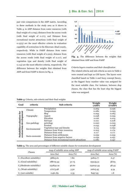
pair wise comparisons in the AHP matrix. According<br />
to these <strong>methods</strong> in the <strong>study</strong> area as it shows in<br />
Table 4, in AHP distance from water resources (with<br />
final weight of 0.1795), distance from the access roods<br />
(with final weight of 0.171), <strong>and</strong> Distance from<br />
recreational tourist attractions (with final weight of<br />
0.1375) are the most effective criteria in <strong>evaluation</strong><br />
capability of <strong>ecotourism</strong> in the Khorram-Abad county,<br />
respectively. While in FAHP distance from water<br />
resources (with final weight of 0.205), distance from<br />
the access roods (with final weight of 0.117), <strong>and</strong><br />
vegetation type <strong>and</strong> density (with final weight of<br />
0.114) are the most effective criteria, respectively. The<br />
difference between the weights that obtained from<br />
AHP <strong>and</strong> from FAHP is shown in Fig. 4.<br />
Fig. 4. The difference between the weights that<br />
obtained from AHP <strong>and</strong> from FAHP<br />
Criteria layers creation <strong>and</strong> their classification<br />
The related criteria <strong>and</strong> sub-criteria as seen in Table 2<br />
were created <strong>and</strong> kept as <strong>GIS</strong> layers. The layers were<br />
classified based on Table 2 <strong>and</strong> fuzzy concept theory,<br />
as the biggest fuzzy number value was assigned <strong>for</strong><br />
the most suitable class. For instance, between slop<br />
classes, the class that has the least slop the biggest<br />
value was assigned.<br />
Table 4. Criteria, sub-criteria <strong>and</strong> their final weights<br />
Goal criteria Sub-criteria<br />
Climate<br />
Topography<br />
Geo-pedology<br />
Environmental<br />
Socio-economic<br />
Weight<br />
(AHP)<br />
Weight<br />
(FAHP)<br />
Precipitation 0.064 0.026<br />
Temperature 0.082 0.093<br />
Slop 0.094 0.063<br />
Aspect 0.058 0.053<br />
Elevation 0.016 0.014<br />
Soil type 0.021 0.018<br />
petrology 0.020 0.029<br />
Erosion 0.035 0.038<br />
Vegetation type <strong>and</strong> density 0.114 0.092<br />
Distance from Water resources 0.205 0.179<br />
Distance from rood 0.117 0.171<br />
Distance from settlements 0.059 0.035<br />
Distance from negative factors 0.039 0.051<br />
Distance from recreational tourist attractions 0.080 0.137<br />
Table 5. The area <strong>and</strong> percentages of different suitable classes <strong>for</strong> <strong>ecotourism</strong> development<br />
Classes<br />
map of suitable areas <strong>using</strong> AHP map of suitable areas <strong>using</strong> FAHP<br />
Area (ha) Area (%) Area (ha) Area (%)<br />
C1 (Excellent <strong>suitability</strong>) 38823.61 7.80 32819.77 6.57<br />
C2 (Good <strong>suitability</strong>) 188719.44 37.75 193145.51 38.65<br />
C3(Moderate <strong>suitability</strong>) 232832.19 46.60 242031.44 48.44<br />
C4 (Weak <strong>suitability</strong>) 27275.98 5.50 22615.45 4.54<br />
C5 (not-suitable) 11461.89 2.35 8497.95 1.8<br />
432 | Mahdavi <strong>and</strong> Niknejad

![Review on: impact of seed rates and method of sowing on yield and yield related traits of Teff [Eragrostis teff (Zucc.) Trotter] | IJAAR @yumpu](https://documents.yumpu.com/000/066/025/853/c0a2f1eefa2ed71422e741fbc2b37a5fd6200cb1/6b7767675149533469736965546e4c6a4e57325054773d3d/4f6e6531383245617a537a49397878747846574858513d3d.jpg?AWSAccessKeyId=AKIAICNEWSPSEKTJ5M3Q&Expires=1716487200&Signature=NBqdU64Bkmb%2B6JgRcbfm5nrhy8w%3D)


