
Create successful ePaper yourself
Turn your PDF publications into a flip-book with our unique Google optimized e-Paper software.
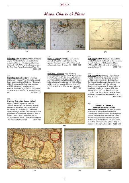
373<br />
373<br />
Irish Map: Camden (Wm.) Hiberniae Ireland<br />
Anglis. Yverdon Brittanis Erin incolis. Ierna<br />
... Ioyernia Ptol, c. 1610. approx. 28.5cms x<br />
36cms, (11¼” x 14”), hand coloured, engd.<br />
by Wm. Hole. Framed. Attractive Map. (1)<br />
€380 - 450<br />
374<br />
Irish Map: Orteluis (A.) Eryn Hiberniae<br />
Brittannicae Insulae Nova Descriptio. Irlandt.<br />
From a Latin edition of Ortelius - ‘Theatrum<br />
Orbis Terrarum’ published in Amsterdam<br />
c. 1603. Attractively hand coloured,<br />
approx. 37cms x 49cms (14½” x 19½), worn<br />
somewhat at centre fold, in hogarth frame.<br />
(1) €1000 - 1500<br />
375<br />
Irish Sea Chart: Van Keulen (Johan)<br />
Nieuve Pascaert vande suyt syde van<br />
Yrlandt, Beginnende van Blasques totande<br />
Hoeck van Waterfoort, Met Al syn diepten<br />
en Droochten,... Large engd. chart with<br />
attractive engd. & hand coloured cartouche,<br />
published in Amsterdam, approx. 51cms x<br />
58cms (19½” x 22¾”), framed. Rare. (1)<br />
* Covers the Southern Coast of Ireland from<br />
The Blaskets to Waterford. €350 - 450<br />
M ealy’s<br />
E s t a b l i s h e d 1 9 3 4<br />
Maps, Charts & Plans<br />
376<br />
Irish Sea Chart: Collins (G.) The Channel<br />
and City of Dublin, engd. chart c. 1775,<br />
approx. 46cms x 54cms (18” x 21¼”), hand<br />
coloured, in hogarth frame. (1) €200 - 320<br />
377<br />
Irish Map - Fisheries: Map of Ireland,<br />
Showing the Districts into which the Coast has<br />
been Divided and the Principal Lakes, Rivers<br />
and Fishery Stations, Published by Standidge<br />
& Co. Lithographers London, c. 1860, all hd.<br />
cold. in outline, approx. 69cms x 53cms (27”<br />
x 21”), in gilt frame. A Scarce Map, v. good.<br />
(1) €220 - 320<br />
380<br />
4<br />
375<br />
376<br />
378<br />
Irish Map: Griffith (Richard) The Southern<br />
Coast of Ireland, form Mouth of the Shannon<br />
to Cork Harbour, c. 1839, approx. 61cms<br />
x 74cms (24” x 29”), hd. cold. in outline, in<br />
hogarth frame. (1) €100 - 150<br />
379<br />
Irish Map: Moll (Herman) A New Map of<br />
Ireland, Divided into Provinces, Counties<br />
and Baronies, wherein are distinguished<br />
the Bishopricks, Boroughs, Barracks, Bogs,<br />
Passes Bridges etc., with the principal<br />
Roads, and the common Reputed Miles. A<br />
very large engd. map, approx. 150cms x<br />
65cms (59” x 25½”), published London c.<br />
1714, hd. cold. in outline, somewhat faded<br />
and worn. Framed, but not glazed. As a<br />
map, w.a.f. (1) €350 - 500<br />
380<br />
The Bogs in Tipperary,<br />
Kilkenny & Queens County<br />
Aher (David) Surveyor, The Bogs of District<br />
8, Situated in the Counties of Tipperary,<br />
Kilkenny and Queens County, including areas<br />
around Templetuohy, Templemore, up to<br />
Roscrea, to Borris-in-Ossory and down to<br />
Rathdowney. Printed Lond. 1814, hd. cold.<br />
in outline, 52cms x 64cms (20½” x 25”), in<br />
black wooden frame. Good. (1) €250 - 350<br />
374 377<br />
379