Yosemite High Country (Tom Harrison Maps)
Yosemite High Country (Tom Harrison Maps)
Yosemite High Country (Tom Harrison Maps)

You also want an ePaper? Increase the reach of your titles
YUMPU automatically turns print PDFs into web optimized ePapers that Google loves.
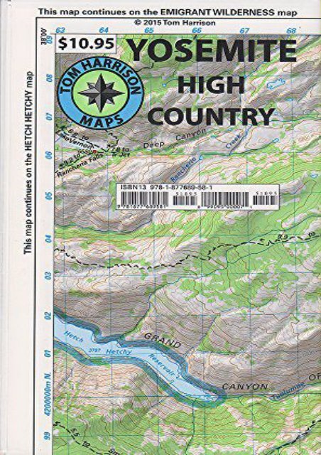
<strong>Yosemite</strong> <strong>High</strong> <strong>Country</strong> (<strong>Tom</strong> <strong>Harrison</strong> <strong>Maps</strong>) (<strong>Tom</strong> <strong>Harrison</strong>) Explore the <strong>Yosemite</strong> high country with this detailed topographic map, which gives contours, trails and other information for campers, hikers, and outdoor enthusiasts.Within this map is;Merced Lake * Wawona * Ten Lakes * Tuolumne Meadows * Tioga Pass * Vogolsang * Bridesveil Creek GPS compatible! Complete UTM Grid. Beautifully design over the USGS topographic quads, enhanced with shaded relief.<br />
<strong>Yosemite</strong> <strong>High</strong> <strong>Country</strong> (<strong>Tom</strong> <strong>Harrison</strong> <strong>Maps</strong>)
Product details<br />
●<br />
●<br />
●<br />
●<br />
●<br />
●<br />
Author : <strong>Tom</strong> <strong>Harrison</strong><br />
Pages : 1 pages<br />
Publisher : <strong>Tom</strong> <strong>Harrison</strong> <strong>Maps</strong> 2014-01-01<br />
Language : English<br />
ISBN-10 : 1877689580<br />
ISBN-13 : 9781877689581
<strong>Yosemite</strong> <strong>High</strong> <strong>Country</strong> (<strong>Tom</strong> <strong>Harrison</strong> <strong>Maps</strong>)
![United States Explorer [Tubed] (National Geographic Reference Map)](https://img.yumpu.com/59273430/1/184x260/united-states-explorer-tubed-national-geographic-reference-map.jpg?quality=85)

![Italy Classic [Tubed] (National Geographic Reference Map)](https://img.yumpu.com/59273374/1/184x260/italy-classic-tubed-national-geographic-reference-map.jpg?quality=85)