Lake George, Great Sacandaga: Adirondack Park (National Geographic Trails Illustrated Map)
Lake George, Great Sacandaga: Adirondack Park (National Geographic Trails Illustrated Map)
Lake George, Great Sacandaga: Adirondack Park (National Geographic Trails Illustrated Map)

Create successful ePaper yourself
Turn your PDF publications into a flip-book with our unique Google optimized e-Paper software.
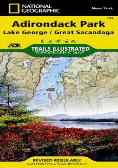
<strong>Lake</strong> <strong>George</strong>, <strong>Great</strong> <strong>Sacandaga</strong>: <strong>Adirondack</strong> <strong>Park</strong> (<strong>National</strong> <strong>Geographic</strong> <strong>Trails</strong> <strong>Illustrated</strong> <strong>Map</strong>) (<strong>National</strong> <strong>Geographic</strong> <strong>Map</strong>s - <strong>Trails</strong> <strong>Illustrated</strong>) • Waterproof • Tear-Resistant • Topographic <strong>Map</strong><strong>National</strong> <strong>Geographic</strong>’s <strong>Trails</strong> <strong>Illustrated</strong> map of <strong>Adirondack</strong> <strong>Park</strong>, <strong>Lake</strong> <strong>George</strong> / <strong>Great</strong> <strong>Sacandaga</strong> combines unmatched detail with helpful information to offer an invaluable tool for making the most of your visit to this scenic region. Expertly researched and created in partnership with local land management agencies including the <strong>Adirondack</strong> Mountain Club, this map features key points of interest including <strong>Lake</strong> <strong>George</strong>, Hammond Pond, and Wilcox <strong>Lake</strong> wild forests; <strong>Great</strong> <strong>Sacandaga</strong> <strong>Lake</strong>; Moreau <strong>Lake</strong> State <strong>Park</strong>; Pharoah <strong>Lake</strong> and Hoffman Notch wilderness areas; and <strong>Lake</strong> Luzerne. This map can guide you off the beaten path and back again with miles of mapped trails complete with mileage between intersections. A trail chart with locations, mileage, and designated use will help you choose a trail that’s right for your activity level, whether you’re hiking, horseback riding, biking, cross country skiing, snowshoeing, or snowmobiling. The map base includes contour lines and elevations for summits and many lakes. Some of the many recreation features noted include ski areas, boat launches, fishing and swimming areas, interpretive trails, campgrounds, and rock and ice climbing<br />
areas. A variety of helpful safety information is included as well. Every <strong>Trails</strong> <strong>Illustrated</strong> map is printed on "Backcountry Tough" waterproof, tear-resistant paper. A full UTM grid is printed on the map to aid with GPS navigation.Other features found on this map include: Baldhead Mountain, Black Spruce Mountain, Brant <strong>Lake</strong>, <strong>Great</strong> <strong>Sacandaga</strong> <strong>Lake</strong>, Kayaderosseras Range, <strong>Lake</strong> <strong>George</strong>, Luzerne Mountains, Pharaoh Mountain, <strong>Sacandaga</strong> River, Saratoga Springs, Schroon <strong>Lake</strong>, Tongue Mountain Range, Wilton.<strong>Map</strong> Scale = 1:75,000Sheet Size = 25.5" x 37.75"Folded Size = 4.25" x 9.25"<br />
<strong>Lake</strong> <strong>George</strong>, <strong>Great</strong> <strong>Sacandaga</strong>: <strong>Adirondack</strong> <strong>Park</strong> (<strong>National</strong><br />
<strong>Geographic</strong> <strong>Trails</strong> <strong>Illustrated</strong> <strong>Map</strong>)
Product details<br />
● Author : <strong>National</strong> <strong>Geographic</strong> <strong>Map</strong>s - <strong>Trails</strong><br />
<strong>Illustrated</strong><br />
●<br />
Pages : 2 pages<br />
● Publisher : <strong>National</strong> <strong>Geographic</strong> <strong>Map</strong>s 2012-<br />
01-01<br />
●<br />
●<br />
●<br />
Language : English<br />
ISBN-10 : 1566953634<br />
ISBN-13 : 9781566953634
<strong>Lake</strong> <strong>George</strong>, <strong>Great</strong> <strong>Sacandaga</strong>: <strong>Adirondack</strong> <strong>Park</strong><br />
(<strong>National</strong> <strong>Geographic</strong> <strong>Trails</strong> <strong>Illustrated</strong> <strong>Map</strong>)


![China Classic [Tubed] (National Geographic Reference Map)](https://img.yumpu.com/59274719/1/184x260/china-classic-tubed-national-geographic-reference-map.jpg?quality=85)