Stratigraphy well correlation.pdf - GNS Science
Stratigraphy well correlation.pdf - GNS Science
Stratigraphy well correlation.pdf - GNS Science

You also want an ePaper? Increase the reach of your titles
YUMPU automatically turns print PDFs into web optimized ePapers that Google loves.
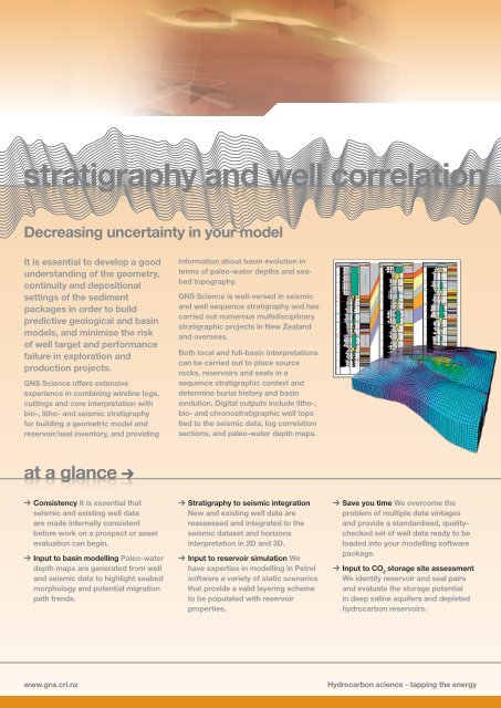
stratigraphy and <strong>well</strong> <strong>correlation</strong><br />
Decreasing uncertainty in your model<br />
It is essential to develop a good<br />
understanding of the geometry,<br />
continuity and depositional<br />
settings of the sediment<br />
packages in order to build<br />
predictive geological and basin<br />
models, and minimise the risk<br />
of <strong>well</strong> target and performance<br />
failure in exploration and<br />
production projects.<br />
<strong>GNS</strong> <strong>Science</strong> offers extensive<br />
experience in combining wireline logs,<br />
cuttings and core interpretation with<br />
bio-, litho- and seismic stratigraphy<br />
for building a geometric model and<br />
reservoir/seal inventory, and providing<br />
at a glance<br />
Consistency It is essential that<br />
seismic and existing <strong>well</strong> data<br />
are made internally consistent<br />
before work on a prospect or asset<br />
evaluation can begin.<br />
Input to basin modelling Paleo-water<br />
depth maps are generated from <strong>well</strong><br />
and seismic data to highlight seabed<br />
morphology and potential migration<br />
path trends.<br />
www.gns.cri.nz<br />
information about basin evolution in<br />
terms of paleo-water depths and seabed<br />
topography.<br />
<strong>GNS</strong> <strong>Science</strong> is <strong>well</strong>-versed in seismic<br />
and <strong>well</strong> sequence stratigraphy and has<br />
carried out numerous multidisciplinary<br />
stratigraphic projects in New Zealand<br />
and overseas.<br />
Both local and full-basin interpretations<br />
can be carried out to place source<br />
rocks, reservoirs and seals in a<br />
sequence stratigraphic context and<br />
determine burial history and basin<br />
evolution. Digital outputs include litho-,<br />
bio- and chronostratigraphic <strong>well</strong> tops<br />
tied to the seismic data, log <strong>correlation</strong><br />
sections, and paleo-water depth maps.<br />
<strong>Stratigraphy</strong> to seismic integration<br />
New and existing <strong>well</strong> data are<br />
reassessed and integrated to the<br />
seismic dataset and horizons<br />
interpretation in 2D and 3D.<br />
Input to reservoir simulation We<br />
have expertise in modelling in Petrel<br />
software a variety of static scenarios<br />
that provide a valid layering scheme<br />
to be populated with reservoir<br />
properties.<br />
Save you time We overcome the<br />
problem of multiple data vintages<br />
and provide a standardised, qualitychecked<br />
set of <strong>well</strong> data ready to be<br />
loaded into your modelling software<br />
package.<br />
Input to CO 2 storage site assessment<br />
We identify reservoir and seal pairs<br />
and evaluate the storage potential<br />
in deep saline aquifers and depleted<br />
hydrocarbon reservoirs.<br />
Hydrocarbon science - tapping the energy
<strong>Stratigraphy</strong> and <strong>well</strong> <strong>correlation</strong><br />
projects<br />
recent projects<br />
recent<br />
A review of litho-, biostratigraphy<br />
and paleobathymetry based on <strong>well</strong><br />
data from central Taranaki Basin (Tui,<br />
Maui and Maari petroleum fields) has<br />
been carried out to reassess existing<br />
stratigraphic framework and seismicto-<strong>well</strong><br />
ties. New stratigraphic dataset<br />
and <strong>well</strong> <strong>correlation</strong> sections have been<br />
created. The data are compatible with<br />
seismic mapping in Geoframe/SeisWare,<br />
static geo-modelling in Petrel and basin<br />
modelling in PetroMod.<br />
about us<br />
about us<br />
<strong>GNS</strong> <strong>Science</strong> has been conducting leading edge research in hydrocarbon exploration for over 30 years and more recently in CO2 storage. With a team of over 60 staff in the Natural Resources Group, we apply experience in satisfying client requirements to<br />
provide a seamless link between scientific research and end-user needs in all aspects of exploration.<br />
contact us<br />
contact us<br />
Please contact us for no-obligation<br />
technical advice on how basin modelling<br />
will bring new understanding to your<br />
exploration area.<br />
We developed a comprehensive <strong>well</strong><br />
summary sheet database for Taranaki<br />
and New Zealand frontier basins,<br />
identifying reservoirs and seals. The<br />
database links multiple vintages of<br />
drilling operations, acquisitions and<br />
post-<strong>well</strong> study data and currently<br />
includes 110 exploration and appraisal<br />
<strong>well</strong>s.<br />
VISIT www.gns.cri.nz/hydrocarbons<br />
CALL +64-4-570 4683<br />
+64-4-570 4550<br />
EMAIL hydrocarbons@gns.cri.nz<br />
An integrated workflow has been<br />
applied to characterise clastic<br />
reservoirs in the Kupe region, southern<br />
Taranaki Basin. The methodology uses<br />
simultaneous integration of geological<br />
and geophysical data in 3D to define the<br />
distribution of source rocks, reservoirs<br />
and seals; extract facies from seismic<br />
attributes; build a static geo-model<br />
on a regional scale and construct<br />
a 4D petroleum system model of<br />
hydrocarbons generation and migration.<br />
<strong>GNS</strong> <strong>Science</strong><br />
1 Fairway Drive, Avalon<br />
Lower Hutt 5010<br />
PO Box 30368<br />
Lower Hutt 5040<br />
New Zealand<br />
T +64-4-570 1444<br />
F +64-4-570 4600<br />
www.gns.cri.nz Hydrocarbon science - tapping the energy