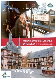

Create successful ePaper yourself
Turn your PDF publications into a flip-book with our unique Google optimized e-Paper software.
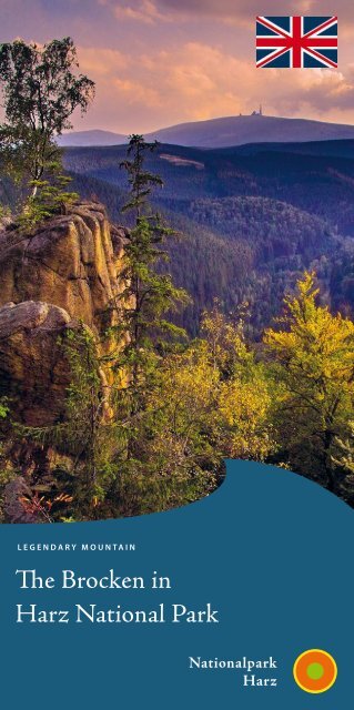
Legendary <strong>Mountain</strong><br />
The <strong>Brocken</strong> in<br />
Harz National Park
The <strong>Brocken</strong> I 1<br />
Dear National Park guests<br />
Do you want to know why <strong>the</strong> spruce on <strong>Brocken</strong> are barely<br />
taller than 5 metres, when <strong>the</strong> <strong>Brocken</strong> Railway first reached<br />
<strong>the</strong> mountain top, or when <strong>the</strong> National Park was established?<br />
Then this brochure should accompany you during your visit to<br />
<strong>the</strong> highest mountain in nor<strong>the</strong>rn Germany.<br />
Even if you have chosen one of <strong>the</strong> more than 300 foggy days<br />
in <strong>the</strong> year, <strong>the</strong> approximately 1.6 km long circular walk offers<br />
much to see. On a clear, dry day <strong>the</strong> maximum visibility is at<br />
least 230 km.<br />
Numbers guide you along <strong>the</strong> path and<br />
through this booklet (on <strong>the</strong> walk, look for<br />
white numerals on a dark wooden sign).<br />
For a plan of <strong>the</strong> <strong>Brocken</strong>, see page 12.<br />
Please contact us if you want to know more <strong>about</strong> Harz National<br />
Park and <strong>Brocken</strong>. Meet us on top of <strong>the</strong> <strong>Brocken</strong> or on<br />
<strong>the</strong> paths <strong>the</strong>re.<br />
Of course you can also join our guided walks on <strong>the</strong> <strong>Brocken</strong>,<br />
which start every day at 11:00 and 13:00 (May to October) at<br />
<strong>the</strong> entrance of <strong>the</strong> wea<strong>the</strong>r station or at 12:00 (November to<br />
April) at <strong>the</strong> entrance of <strong>the</strong> <strong>Brocken</strong>haus.<br />
Your National Park Rangers<br />
1 Views of <strong>the</strong> Harz foothills<br />
From board 1 you see lying in front of you not only Renneckenberg,<br />
Hohnekamm and Jägerkopf, but also Wernigerode<br />
Castle (13 km) and Halberstadt (32 km).<br />
When you look closely you will notice that <strong>the</strong> Harz foothills<br />
are characterized by intensive industrial and agricultural use,<br />
while forestry predominates in <strong>the</strong> Harz. Ordered, equalheight<br />
treetops in geometric areas show where natural forests<br />
were converted into managed spruce forests long before <strong>the</strong><br />
designation of <strong>the</strong> National Park. However, original nature<br />
could survive where <strong>the</strong> economic activities of man could not,<br />
especially at high altitudes or on <strong>the</strong> steep slopes of <strong>the</strong> valleys.<br />
2 <strong>Brocken</strong> Railway<br />
As early as 1899 <strong>the</strong> 100 cm gauge <strong>Brocken</strong> Railway<br />
was laid from Drei Annen Hohne via Schierke to <strong>the</strong> <strong>Brocken</strong>.<br />
It negotiates an ascent of 588 metres on <strong>the</strong> 16 km route.<br />
From 1961 only supply trains of <strong>the</strong> GDR border troops<br />
reached <strong>the</strong> summit.<br />
Since 1991, steam locomotives have been rolling again carrying<br />
holiday traffic to <strong>the</strong> <strong>Brocken</strong>. Thus, <strong>the</strong> railway could be<br />
integrated into <strong>the</strong> concept of visitor guidance to <strong>the</strong> <strong>Brocken</strong><br />
through <strong>the</strong> Harz National Park. Since <strong>the</strong> train track passes<br />
<strong>Brocken</strong> profile<br />
• At 1,141 metres above sea level, <strong>the</strong> highest mountain<br />
in nor<strong>the</strong>rn Germany<br />
• The only German central mountain peak with a natural<br />
forest line<br />
• Heath vegetation probably since <strong>the</strong> Ice Age<br />
• Climate like <strong>the</strong> Alps at 1,800-2,500 metres above sea<br />
level<br />
• Annual average temperature is <strong>about</strong> 4°C<br />
• Mystic mountain: scene of Walpurgis Night in<br />
Goe<strong>the</strong>‘s „Faust“.
2 I <strong>the</strong> <strong>Brocken</strong> The <strong>Brocken</strong> I 3<br />
6<br />
1 Osterwieck (20 km)<br />
2 Ilsenburg (9 km)<br />
3 Huy (32 km)<br />
4 Magdeburg (79 km)<br />
5 Halberstadt (32 km)<br />
6 Wernigerode (13 km)<br />
7 Hakel (37 km)<br />
8 Quedlinburg (36 km)<br />
9 Elbingerode (13 km)<br />
10 Halle (100 km)<br />
11 Eisleben (71 km),<br />
Harzgerode (41 km)
4 I <strong>the</strong> <strong>Brocken</strong> The <strong>Brocken</strong> I 5<br />
through some of <strong>the</strong><br />
most sensitive areas<br />
of <strong>the</strong> National<br />
Park, <strong>the</strong> National<br />
Park Authority is<br />
committed to close<br />
cooperation with<br />
<strong>the</strong> <strong>Brocken</strong> Railway<br />
for an environmentally<br />
friendly<br />
operation. Only by acting toge<strong>the</strong>r can potential damage to<br />
natural resources be averted.<br />
3 <strong>Brocken</strong> Garden<br />
The show and experimental garden on <strong>the</strong> <strong>Brocken</strong> was founded<br />
in 1890 by Prof. Dr. Albert Peter, at that time Director of<br />
<strong>the</strong> Botanical Garden of <strong>the</strong> Georg August University of Göttingen.<br />
Until 1949, Göttingen University was responsible for<br />
<strong>the</strong> Garden, <strong>the</strong>n Martin Lu<strong>the</strong>r University Halle-Wittenberg,<br />
and finally, after 1990, <strong>the</strong> National Park.<br />
<strong>Brocken</strong> Garden has always fulfilled conservation and research<br />
tasks, served educational purposes and been made available<br />
to <strong>Brocken</strong> visitors. To achieve <strong>the</strong>se tasks and objectives, <strong>the</strong><br />
Garden was divided into experimental and show plots. The<br />
show part of <strong>the</strong> garden is hard to see from <strong>the</strong> circular path.<br />
You are <strong>the</strong>refore cordially invited to a garden tour, which<br />
starts on weekdays at <strong>the</strong> entrance of <strong>the</strong> meteorological station<br />
at 11:30 and 14:00 (mid-May to mid-October). On weekends<br />
and public holidays, a visit is only possible in combination<br />
with circular walks guided by a Ranger, beginning at 11:00<br />
and 13:00. In <strong>the</strong> Garden <strong>the</strong>re are garden plants introduced<br />
from <strong>the</strong> high mountain regions of <strong>the</strong> world, among o<strong>the</strong>rs. If<br />
you would like to know more, <strong>the</strong>n you can get a booklet called<br />
„<strong>Brocken</strong> Garden in <strong>the</strong> Harz“ from <strong>Brocken</strong>haus.<br />
In board 2 you can<br />
see <strong>the</strong> natural part<br />
of <strong>the</strong> experimental<br />
plot. Studies on <strong>the</strong><br />
restoration of <strong>the</strong><br />
<strong>Brocken</strong> plateau<br />
mainly take place<br />
here.<br />
The splendour of<br />
<strong>the</strong> present <strong>Brocken</strong><br />
Garden is only<br />
possible through intensive<br />
professional<br />
maintenance. Since<br />
<strong>the</strong> beginning, <strong>the</strong>re<br />
were several periods<br />
when <strong>Brocken</strong> Garden<br />
was not at all or<br />
only very irregularly<br />
maintained. This<br />
meant that at <strong>the</strong><br />
start of work by<br />
<strong>the</strong> National Park<br />
in 1990, only 97 of<br />
<strong>the</strong> formerly 1,400<br />
cultivated species<br />
were detected. Today,<br />
visitors to <strong>the</strong><br />
garden can marvel<br />
at more than 1,500<br />
plant species from<br />
<strong>the</strong> high mountain<br />
regions of <strong>the</strong> world. Restoration of <strong>the</strong> <strong>Brocken</strong> summit<br />
and public relations work are essential tasks of this botanical<br />
garden.
6 I <strong>the</strong> <strong>Brocken</strong> The <strong>Brocken</strong> I 7<br />
3<br />
1 Elbingerode (13 km)<br />
2 Kyffhäuser (57 km)<br />
3 Wurmberg (5 km)<br />
4 Großer Inselsberg (106 km)<br />
5 Wartburg (95 km)<br />
6 Ravensberg (21 km),<br />
Stöberhai (17 km)<br />
7 Bad Lauterberg (22 km)<br />
8 Achtermannshöhe (5 km)<br />
9 Großer Knollen (20 km)<br />
10 Meißner (85 km)<br />
11 Kahler Asten (163 km)
8 I <strong>the</strong> <strong>Brocken</strong> The <strong>Brocken</strong> I 9<br />
4 Devil’s Pulpit and Witches Altar<br />
5 Dwarf shrub heath<br />
Inspired by <strong>the</strong> impressions of his first ascent of <strong>Brocken</strong> in<br />
winter 1777, Johann Wolfgang Goe<strong>the</strong> wrote <strong>the</strong> Walpurgis<br />
scene for „Faust“. On Walpurgis Night, <strong>the</strong> night of April<br />
30th, according to tradition witches meet on „Blocksberg“ (<strong>the</strong><br />
<strong>Brocken</strong>) at <strong>the</strong> Devil‘s Pulpit and <strong>the</strong> Witches Altar, where<br />
<strong>the</strong>y wildly sweep away <strong>the</strong> last snow of <strong>the</strong> <strong>Brocken</strong> with <strong>the</strong>ir<br />
brooms. In <strong>the</strong> late 19th century this event became a kind of<br />
festival. In 1896 <strong>the</strong> Bad Harzburg Walpurgisnacht society<br />
celebrated on <strong>the</strong> <strong>Brocken</strong> for <strong>the</strong> first time. Since 1901 <strong>the</strong>re<br />
have been special Walpurgis trains of <strong>the</strong> <strong>Brocken</strong> railway. In<br />
<strong>the</strong> following years, Count Christian Ernst of Stolberg-Wernigerode<br />
banned <strong>the</strong> Walpurgis celebrations because of <strong>the</strong><br />
„hellish noise and rough horseplay“.<br />
Today, Walpurgis Night is celebrated in communities in <strong>the</strong><br />
National Park, such as Ilsenburg, Bad Harzburg, Schierke,<br />
Sankt Andreasberg, Braunlage and Elend.<br />
The granite cliffs facing you remain unmolested by dancing<br />
witches and over <strong>the</strong> decades have become covered with <strong>the</strong><br />
sensitive map lichen.<br />
On a clear day you have <strong>the</strong> good view shown in board 4.<br />
Above <strong>the</strong> natural tree line on <strong>the</strong> <strong>Brocken</strong> <strong>the</strong>re are <strong>the</strong> remnants<br />
of <strong>the</strong> once large-scale dwarf shrub heath. The formation<br />
of a closed forest after <strong>the</strong> last ice age was prevented here by<br />
thin, nutrient-poor<br />
soils, a harsh climate,<br />
and especially by<br />
<strong>the</strong> wind – conditions<br />
for <strong>the</strong> natural<br />
occurrence of <strong>the</strong>se<br />
heathland communities.<br />
Typical species<br />
which grow on <strong>the</strong><br />
<strong>Brocken</strong> are <strong>Brocken</strong><br />
anemone, <strong>Brocken</strong> hawkweed and Alpine hawkweed. The<br />
presence of <strong>the</strong>se light-demanding species is an indication of <strong>the</strong><br />
lack of forest cover on <strong>the</strong> <strong>Brocken</strong> plateau since <strong>the</strong> end of <strong>the</strong><br />
last ice age <strong>about</strong> 10,000 years ago.<br />
The existing heathlands were strongly influenced over time<br />
by human use on <strong>the</strong> plateau. Over <strong>the</strong> centuries, grazing and<br />
tourism have encouraged <strong>the</strong> spread of dwarf shrubs such as<br />
hea<strong>the</strong>r, bilberry and cranberry and changed <strong>the</strong> character of<br />
<strong>the</strong> <strong>Brocken</strong>. Although as a result of large-scale restoration<br />
<strong>the</strong> number of potential locations for <strong>Brocken</strong> anemone and<br />
<strong>Brocken</strong> hawkweed have increased again (both occur only here<br />
in Germany), <strong>the</strong>y are highly endangered.<br />
Previously picked for „<strong>Brocken</strong> bouquets“, <strong>the</strong> natural heathland<br />
vegetation is being threatened today because <strong>the</strong> nutrients<br />
contained in precipitation (e.g. 60 kg of nitrogen per hectare per<br />
year on <strong>Brocken</strong> summit) favour <strong>the</strong> spread of highly competitive<br />
grasses such as Tufted Hairgrass and Hairy Reed Grass.
10 I <strong>the</strong> <strong>Brocken</strong> The <strong>Brocken</strong> I 11<br />
1 Ravensberg (21 km),<br />
Stöberhai (17 km)<br />
2 Achtermannshöhe (5 km)<br />
3 Meißner (85 km), Gleichen<br />
(54 km), Königsberg / Goe<strong>the</strong>moor<br />
(2,5 km)<br />
4 Kassel (98 km), Göttingen<br />
(56 km)<br />
5 Hoher Hagen (69 km),<br />
Sonnenberg (8 km)<br />
6 Clausthal-Zellerfeld (19 km)<br />
7 Abbenstein (4 km)<br />
8 Langelsheim (25 km),<br />
Rammelsberg (16 km)
12 I <strong>the</strong> The <strong>Brocken</strong> The <strong>Brocken</strong> I 13<br />
8<br />
9<br />
7<br />
10<br />
6<br />
5<br />
11<br />
4<br />
1<br />
2<br />
3
14 I <strong>the</strong> <strong>Brocken</strong> The <strong>Brocken</strong> I 15<br />
6 Harz National Park – legendary mountain wilderness<br />
7 Natural forest line<br />
We associate <strong>the</strong> term „National Park“ with exotic animals and<br />
immense rainforests in Africa or America. And indeed <strong>the</strong> national<br />
park idea comes from America where, in 1872, Yellowstone<br />
National Park became <strong>the</strong> first of its kind to protect its natural<br />
beauty. Since <strong>the</strong>n <strong>about</strong> 5,000 precious natural landscapes worldwide<br />
have been protected with this highest distinction. In 1990<br />
approximately 60 km 2 of Saxony-Anhalt was given National Park<br />
status – Harz National Park with <strong>the</strong> <strong>Brocken</strong>. When looking to<br />
<strong>the</strong> west from board 6 you can see <strong>the</strong> TV towers on Torfhaus.<br />
Here is <strong>the</strong> approximately 158 km 2 Lower Saxony Harz National<br />
Park, added in 1994. With an 89 km 2 extension of <strong>the</strong> Upper<br />
Harz National Park in 2001 and <strong>the</strong> merger of <strong>the</strong> two Parks<br />
in 2006, we have today’s Harz National Park, at approximately<br />
247 km 2 .<br />
Many rare animal<br />
and plant species<br />
live in <strong>the</strong> mountain<br />
spruce, beech and<br />
mixed deciduous<br />
forests, <strong>the</strong> bogs,<br />
mountain streams,<br />
granite cliffs, and <strong>the</strong><br />
dwarf shrub heath of<br />
<strong>the</strong> National Park.<br />
The most pristine habitats are protected in natural dynamics zone.<br />
Here no intervention takes place. In <strong>the</strong> natural development<br />
zone <strong>the</strong>re are areas of spruce that were once planted for forestry<br />
purposes; <strong>the</strong>se are now being turned back into natural forest by<br />
adding deciduous trees and opening <strong>the</strong>m up to more light. These<br />
human activities will continue for some years. The <strong>Brocken</strong> summit<br />
itself is in <strong>the</strong> utilization zone of <strong>the</strong> National Park.<br />
The aim of <strong>the</strong> Harz National Park is to stop human intervention<br />
in at least 75% of <strong>the</strong> National Park, in accordance with <strong>the</strong> motto<br />
„let nature be nature“.<br />
The closed spruce forest on <strong>the</strong> <strong>Brocken</strong> has a natural forest<br />
line at <strong>about</strong> 1,100 metres above sea level. This nor<strong>the</strong>rnmost<br />
natural forest line in Central Europe is particularly valuable<br />
for nature conservation. It is caused by <strong>the</strong> special climatic<br />
conditions here on <strong>the</strong> highest Harz mountain. Among <strong>the</strong> limiting<br />
factors <strong>the</strong> wind is especially important, preventing <strong>the</strong><br />
creation of a closed forest on <strong>Brocken</strong> plateau and so creating<br />
space for <strong>the</strong> dwarf shrub heath.<br />
As <strong>the</strong> windiest place in Germany (on 24.11.1984 a wind<br />
speed of 263 km/h was measured), <strong>the</strong> <strong>Brocken</strong> is <strong>the</strong> only<br />
naturally forest-free part of <strong>the</strong> central German uplands. The<br />
climatic conditions (approximately 4°C mean annual temperature,<br />
1,800 mm annual rainfall and <strong>about</strong> 300 foggy days) and<br />
<strong>the</strong> ecological conditions at 1,141 metres on <strong>the</strong> <strong>Brocken</strong> are<br />
comparable to those at <strong>about</strong> 2,000 metres above sea level in<br />
<strong>the</strong> Alps. The reason for this is <strong>the</strong> exposed, nor<strong>the</strong>rn location<br />
of <strong>the</strong> Harz. The mountain stands as an insurmountable<br />
obstacle in <strong>the</strong> North German Plain. Therefore, it is always exposed<br />
to <strong>the</strong> winds and storms which predominantly transport<br />
humid air masses from <strong>the</strong> southwest.
16 I <strong>the</strong> <strong>Brocken</strong> The <strong>Brocken</strong> I 17<br />
8 Hirtenstieg / Heinrich Heine Way<br />
9 Boulder field<br />
Coming from <strong>the</strong> north you can reach <strong>the</strong> <strong>Brocken</strong> on <strong>the</strong><br />
Hirtenstieg (following <strong>the</strong> same course as <strong>the</strong> Harz border<br />
path along <strong>the</strong> Green Belt). Alongside <strong>the</strong> <strong>Brocken</strong> Street and<br />
<strong>the</strong> Eckerloch Stieg from <strong>the</strong> sou<strong>the</strong>ast and <strong>the</strong> Goe<strong>the</strong>weg<br />
from <strong>the</strong> west, it is <strong>the</strong> only access for walkers to <strong>the</strong> <strong>Brocken</strong><br />
plateau. For 3.4 km it follows a partly concrete-paved former<br />
patrol road to Scharfenstein<br />
Ranger Station,<br />
which is a popular<br />
hiking destination with<br />
its daily-open rest hut.<br />
On 20 September<br />
1824 <strong>the</strong> poet Heinrich<br />
Heine hiked<br />
from Harzburg to <strong>the</strong><br />
<strong>Brocken</strong>. The descent continued to Ilsenburg in <strong>the</strong> north. In<br />
his honour, <strong>the</strong> name Heinrich Heine Way is also used for <strong>the</strong><br />
Hirtenstieg, which was possibly previously used by shepherds<br />
driving <strong>the</strong>ir livestock to pasture on <strong>the</strong> <strong>Brocken</strong>. The ascent<br />
from Ilsenburg onto <strong>the</strong> <strong>Brocken</strong> is considered <strong>the</strong> most<br />
beautiful.<br />
Heine transformed his impressions of <strong>the</strong> ascent into words<br />
in his „Harz Journey“: „The higher we ascend, so much <strong>the</strong><br />
shorter and more dwarf-like do <strong>the</strong> fir-trees become, shrinking<br />
up, as it were, within <strong>the</strong>mselves, until finally only whortleberries,<br />
bilberries, and mountain herbs remain. It is also sensibly<br />
colder. ... for it is a road which is to <strong>the</strong> last degree exhausting,<br />
and I was glad enough when I at last beheld <strong>the</strong> long-desired<br />
<strong>Brocken</strong> house.“<br />
You can visit <strong>the</strong> new <strong>Brocken</strong>haus if you climb <strong>the</strong> stairs to<br />
<strong>the</strong> entrance on board 9. There you will find a modern exhibition<br />
on <strong>the</strong> subjects of geopark, witches, German history,<br />
The geological history of <strong>the</strong> <strong>Brocken</strong> area reaches far back<br />
into <strong>the</strong> Paleozoic. In <strong>the</strong> Devonian, where <strong>the</strong> Upper Harz today<br />
lies, sediments were deposited in a primordial sea. About<br />
300 million years ago, in <strong>the</strong> Carboniferous, <strong>the</strong>se were folded<br />
by plate tectonics into <strong>the</strong> ancient Harz. Then hot magma<br />
from <strong>the</strong> deeper regions of <strong>the</strong> earth rose up; however, it did<br />
not reach <strong>the</strong> surface but cooled slowly at a depth of more<br />
than 2,000 metres. The result is a so-called pluton, consisting<br />
of coarse-grained granite which is composed of <strong>the</strong> minerals<br />
feldspar, quartz and mica.<br />
With <strong>the</strong> magma pushing upward, <strong>the</strong> surrounding rocks<br />
undergo contact metamorphism at almost 1,000 °C and<br />
transform into hard and splintery hornfels. For almost 100<br />
million years ago, during <strong>the</strong> Cretaceous and <strong>the</strong> Tertiary, <strong>the</strong><br />
entire Harz was lifted as what is known as a ‘half-horse’ during<br />
alpidic orogeny. This ‘horse’ rises uniformly from <strong>the</strong> south and<br />
is cut off in <strong>the</strong> north. At <strong>the</strong> same time erosion increased on<br />
<strong>the</strong> surface. The granite<br />
was exposed and <strong>the</strong><br />
<strong>Brocken</strong> literally etched<br />
into <strong>the</strong> relief from<br />
<strong>the</strong> Harz plateau. The<br />
granite itself was wea<strong>the</strong>red<br />
into shape by <strong>the</strong><br />
so-called woolsack wea<strong>the</strong>ring.<br />
The resulting<br />
cliffs crumbled into boulder fields and are found everywhere<br />
in <strong>the</strong> Harz, especially here on <strong>the</strong> <strong>Brocken</strong>. They are home to<br />
many rare lichens, club mosses and mosses; <strong>the</strong>refore <strong>the</strong>y may<br />
not be accessed.<br />
The boulder fields are a designated „National Geotope“ within<br />
<strong>the</strong> National GeoPark „Harz Braunschweiger Land Ostfalen“.<br />
famous <strong>Brocken</strong> visitors and nature in <strong>the</strong> National Park. In<br />
addition, <strong>the</strong>re is a multi-media show and a cafeteria for you.
18 I <strong>the</strong> <strong>Brocken</strong> The <strong>Brocken</strong> I 19<br />
5<br />
1 Bad Harzburg (10 km)<br />
2 Großer Fallstein (25 km)<br />
3 Osterwieck (20 km)<br />
4 Schöppenstedt/<br />
Elm (40 km)<br />
5 Ilsenburg (9 km)<br />
6 Tangermünde (124 km)<br />
7 Huy, Huysburg (32 km)<br />
8 Magdeburg (79 km)<br />
9 Derenburg (22 km),<br />
Wernigerode (13 km)<br />
10 Halberstadt (32 km)
20 I I The <strong>the</strong> <strong>Brocken</strong><br />
The <strong>Brocken</strong> I 21<br />
<strong>Brocken</strong> summit<br />
in 1983<br />
10 Bog<br />
Bogs are very sensitive habitats in which numerous specialists<br />
of <strong>the</strong> plant and animal kingdom are at home. Small-scale slope<br />
bogs, as at this location, are spread in a mosaic among <strong>the</strong><br />
mountain spruce forest of <strong>the</strong> <strong>Brocken</strong>. Slope bogs are mostly<br />
young, always lying on slopes, and relatively low nutrient,<br />
acidic ground water flowing through <strong>the</strong>m. A water confining<br />
ground layer at a shallow depth (here <strong>the</strong> granite) and large<br />
amounts of precipitation are <strong>the</strong> conditions for <strong>the</strong>ir creation.<br />
Particularly striking are <strong>the</strong> white seed heads of common<br />
cottongrass in summer. On closer inspection one can also recognize<br />
cranberry, bog bilberry, bog rosemary and crowberry that<br />
occur in drier areas such as <strong>the</strong> edges of <strong>the</strong> slope bog. Particularly<br />
difficult to discover is <strong>the</strong> round-leaved sundew which<br />
is hiding among <strong>the</strong> sphagnum moss. In intact bogs <strong>the</strong> main<br />
plant species are sphagnum mosses, which have an enormous<br />
water storage capacity. There are <strong>about</strong> 25 different species of<br />
<strong>the</strong>m in <strong>the</strong> Harz <strong>Mountain</strong>s.<br />
In <strong>the</strong> National Park <strong>the</strong> bogs are growing even today. For<br />
<strong>the</strong>ir protection it is particularly important to only walk on <strong>the</strong><br />
signposted paths.<br />
11 Building development on <strong>the</strong> <strong>Brocken</strong><br />
The history of <strong>the</strong> <strong>Brocken</strong> is particularly reflected in its<br />
building development. Erected in 1736, for a long time Clouds<br />
Hut was <strong>the</strong> only shelter for tired walkers. In 1800, <strong>the</strong> first<br />
inn came into operation on <strong>the</strong> summit, and thus <strong>the</strong> tradition<br />
of <strong>the</strong> <strong>Brocken</strong> hosts began, and an observation tower was<br />
built. The inn was gradually converted into <strong>the</strong> <strong>Brocken</strong> Hotel,<br />
but this was destroyed by a US air strike in 1945. In addition<br />
to <strong>Brocken</strong> Garden, founded in 1890, <strong>the</strong> <strong>Brocken</strong> summit is<br />
home to <strong>the</strong> oldest German wea<strong>the</strong>r station (1895) and one of<br />
<strong>the</strong> first television towers in Germany (1938). The proportion<br />
of built-up area grew continuously to its 1990 level. Thus <strong>the</strong><br />
sealed area increased from 120 m 2 in 1800 to 53,000 m 2 .<br />
In terms of buildings, <strong>the</strong>re was a 3.60-metre-high concrete<br />
wall around <strong>the</strong> <strong>Brocken</strong> and in particular <strong>the</strong> limestone rubble<br />
from <strong>the</strong> roads and barrack areas, of which <strong>about</strong> 20,000 t was<br />
removed in 1990.<br />
With <strong>the</strong> establishment of <strong>the</strong> National Park and its programme<br />
for <strong>the</strong> restoration of <strong>the</strong> <strong>Brocken</strong>, <strong>the</strong> constructed area was<br />
reduced to <strong>about</strong> 10,000 m 2 . The <strong>Brocken</strong> wall and military<br />
barracks have been removed and <strong>the</strong> <strong>Brocken</strong> flora has taken<br />
hold again.<br />
At <strong>the</strong> highest point of <strong>the</strong> mountain you will find <strong>the</strong> „<strong>Brocken</strong>uhr“,<br />
a 30 m in diameter ring consisting of 48 bronze signs<br />
around a rock made of six granite boulders.
22 I <strong>the</strong> <strong>Brocken</strong> The <strong>Brocken</strong> I 23<br />
Your route to <strong>the</strong> <strong>Brocken</strong><br />
Walkers can reach <strong>the</strong> <strong>Brocken</strong> on three main routes. They<br />
differ in <strong>the</strong> length, but also in <strong>the</strong> ascent to be overcome. You<br />
should make sure you are in good physical condition and you<br />
have sturdy footwear as well as wea<strong>the</strong>rproof clothing; <strong>the</strong><br />
summit is a few degrees colder than at <strong>the</strong> starting point of<br />
your hike and <strong>the</strong> wea<strong>the</strong>r can suddenly change.<br />
Distances are indicated in kilometres in each direction on <strong>the</strong><br />
paths.<br />
The shortest route:<br />
From Schierke via Eckerloch to <strong>Brocken</strong><br />
About 5 km / approx 500 metres of ascent<br />
Even though <strong>the</strong> route via Eckerloch is <strong>the</strong> shortest route to<br />
<strong>the</strong> <strong>Brocken</strong>, it still requires that walkers are in good physical<br />
condition and have<br />
especially good shoes,<br />
because <strong>the</strong> road is<br />
sometimes steep, rocky<br />
and covered with roots.<br />
<strong>Information</strong> <strong>about</strong><br />
alternative routes from<br />
Schierke to <strong>Brocken</strong> is<br />
available at <strong>the</strong> starting<br />
point of <strong>the</strong> walk, Schierke National Park House.<br />
Starting point, fur<strong>the</strong>r information, walk leaflet:<br />
Schierke National Park House on <strong>Brocken</strong> Street, Tel. 03 94<br />
55 /4 77<br />
The least ascent:<br />
From Torfhaus to <strong>Brocken</strong> on <strong>the</strong> Goe<strong>the</strong>weg<br />
About 9 km / <strong>about</strong> 360 metres of ascent<br />
Even Johann Wolfgang Goe<strong>the</strong> started his first ascent of <strong>Brocken</strong><br />
in Torfhaus in December 1777. Which route he <strong>the</strong>n embarked<br />
on through <strong>the</strong> rough terrain and deep snow, we cannot<br />
say exactly. Today, <strong>the</strong><br />
path leads past <strong>the</strong><br />
Great Torfhausmoor<br />
along Abbegrabens,<br />
crosses <strong>the</strong> „Green Belt“<br />
at Eckersprung, <strong>the</strong>n<br />
follows a newly built<br />
section of <strong>the</strong> <strong>Brocken</strong><br />
Railway. The final climb<br />
to <strong>the</strong> summit is via <strong>Brocken</strong> Street.<br />
Starting point, fur<strong>the</strong>r information, walk leaflet:<br />
TorfHaus National Park Visitor Centre at <strong>the</strong> large car park in<br />
Torfhaus, Tel. 0 53 20/33 17 90, www.torfhaus.info<br />
Only for well trained hikers:<br />
From Ilsenburg to <strong>the</strong> <strong>Brocken</strong> on <strong>the</strong> Heinrich Heine Way<br />
About 10 km / <strong>about</strong> 860 metres of ascent<br />
Heinrich Heine wandered down this route in 1824 from <strong>the</strong><br />
<strong>Brocken</strong>; he climbed from Bad Harzburg and spent <strong>the</strong> night<br />
on <strong>the</strong> <strong>Brocken</strong>. Today, you also first of all follow <strong>the</strong> romantic<br />
valley of <strong>the</strong> Ilse from Ilsenburg. Passing <strong>the</strong> Bremer Hut<br />
and Stempelsbuche<br />
you finally get to <strong>the</strong><br />
Hirtenstieg. On this<br />
<strong>the</strong> steepest part of<br />
<strong>the</strong> path <strong>the</strong> gradient<br />
is sometimes up to<br />
20%, following <strong>the</strong> old<br />
paved path of <strong>the</strong> GDR<br />
Border Troops to reach<br />
<strong>the</strong> summit of <strong>Brocken</strong>.<br />
Starting point, fur<strong>the</strong>r information:<br />
Ilsetal National Park House near <strong>the</strong> large car park at <strong>the</strong><br />
bottom of Ilsetal, Tel. 03 94 52 / 8 94 94
24 I <strong>the</strong> The <strong>Brocken</strong> The <strong>Brocken</strong> I 25<br />
Welcome to <strong>Brocken</strong>haus<br />
Awaiting you are three exciting floors of exhibition space and<br />
<strong>the</strong> climb into our dome right up to <strong>the</strong> roof terrace!<br />
Start your journey through <strong>the</strong> diversity of <strong>the</strong> mountain<br />
with <strong>the</strong> virtual flight as a witch and let us take you into <strong>the</strong><br />
world of myths and legends. Experience <strong>the</strong> exciting stories of<br />
famous <strong>Brocken</strong> visitors who have written <strong>about</strong> <strong>Brocken</strong> history<br />
for over two hundred years. Join Hermann Löns with his<br />
ride on his Harz narrow gauge railway. Marvel at <strong>the</strong> tourist<br />
infrastructure on <strong>the</strong> <strong>Brocken</strong> which was already well-developed<br />
in <strong>the</strong> early twentieth century. Explore <strong>the</strong> development of<br />
<strong>the</strong> restricted military area around <strong>the</strong> <strong>Brocken</strong> and <strong>the</strong> construction<br />
of <strong>Brocken</strong> fortress at <strong>the</strong> height of <strong>the</strong> Cold War.<br />
The fascinating insights into <strong>the</strong> large and small wonders of<br />
<strong>the</strong> Harz National Park have <strong>the</strong>ir own dedicated floor in<br />
<strong>the</strong> House. Here you can learn all <strong>about</strong> <strong>the</strong> history, flora and<br />
fauna and <strong>the</strong> many special features of <strong>the</strong> Harz National<br />
Park. Germany‘s only trans-state National Park has a lot of<br />
exciting stories <strong>about</strong> his fascinating habitats for you. Flowing<br />
waters, mountain spruce forests and boulder piles present <strong>the</strong>ir<br />
residents and <strong>the</strong>ir living habits.<br />
The newest section of <strong>the</strong> exhibition in <strong>Brocken</strong>haus is dedicated<br />
to <strong>the</strong> signs of climate change in <strong>the</strong> Harz. Here you can<br />
understand – sometimes even touch – what climate change<br />
means for <strong>the</strong> Harz forest in <strong>the</strong> course of <strong>the</strong> Earth‘s history.<br />
And what would <strong>the</strong> <strong>Brocken</strong> be without its climatic characteristics<br />
and <strong>the</strong> typical <strong>Brocken</strong> wea<strong>the</strong>r conditions? Everything<br />
<strong>about</strong> <strong>the</strong> wea<strong>the</strong>r extremes of <strong>the</strong> mountain – <strong>the</strong> wind, <strong>the</strong><br />
fog and <strong>the</strong> snow, as well as its wea<strong>the</strong>r records – can be found<br />
on our third floor.<br />
German radio and television history was made on <strong>the</strong> <strong>Brocken</strong>.<br />
In <strong>Brocken</strong>haus you can learn interesting facts from <strong>the</strong><br />
early days of motion pictures and can have a look at one of <strong>the</strong><br />
oldest TV towers in Germany.<br />
Before being served in our cosy Hexenflug cafeteria, do not<br />
miss <strong>the</strong> spiral staircase to get into our dome. Here you can see<br />
<strong>the</strong> imposing antennas and parabolic mirrors which <strong>the</strong> GDR<br />
Ministry of State Security used for bugging Western radio<br />
traffic at <strong>the</strong> height of <strong>the</strong> Cold War. Radiotelephones of leading<br />
politicians were <strong>the</strong> focus of <strong>the</strong> monitoring service on <strong>the</strong><br />
<strong>Brocken</strong>, and with <strong>the</strong> latest technology <strong>the</strong>y were in a position<br />
to even intercept calls from across <strong>the</strong> English Channel.<br />
Opening hours:<br />
Daily 9.30 – 17.00<br />
Entrance fees (as of January 2016):<br />
Adults € 5.00 (discounts for children, seniors, groups and<br />
families)<br />
Do you have a HarzCard? Then you have free entry to <strong>Brocken</strong>haus.<br />
Tel. 039455 50005<br />
<strong>Brocken</strong>haus@t-online.de<br />
www.nationalpark-<strong>Brocken</strong>haus.de
Regulations<br />
Due to several million visitors each year, some basic rules for this<br />
nature paradise have to be set in order to guarantee that o<strong>the</strong>rs<br />
will be able to enjoy <strong>the</strong> unimpaired mountain wilderness in<br />
<strong>the</strong> future. Please visit one of our information centres in order to<br />
obtain detailed information on this matter. Please note that we<br />
consider major violations against <strong>the</strong> National Park‘s rules as an<br />
offence which will be punished accordingly.<br />
More than 1,000 bags of litter have to be collected each year<br />
alongside <strong>the</strong> routes in <strong>the</strong> National Park. Please use <strong>the</strong> rubbish<br />
and recycling bins at <strong>the</strong> end of your trip.<br />
Do not remove anything from <strong>the</strong> Park. Each animal and each<br />
plant has its place in <strong>the</strong> nutrient cycle of <strong>the</strong> nature reserve. This<br />
particularly applies to berries and mushrooms.<br />
Do not light fires in <strong>the</strong> National Park! Fire will spread rapidly even<br />
in colder wea<strong>the</strong>r conditions. Each year precious areas are destroyed<br />
by fire.<br />
Please keep your dog on a leash. Your loyal companion may be<br />
tempted if it smells a young deer or lynx. Spare <strong>the</strong> animals <strong>the</strong><br />
stress and your dog <strong>the</strong> danger of disappearing in a deep granite<br />
chasm.<br />
In order to avoid forest fires, please do not smoke in <strong>the</strong> Park<br />
between 15 February and 31 October.<br />
There are access laws in <strong>the</strong> National Park. Please stay on <strong>the</strong> signposted<br />
routes. The Park has 560 kilometres of <strong>the</strong>se routes, which<br />
lead to <strong>the</strong> most fascinating lookout points.<br />
Cycling is allowed on all paths. On a few paths it is restricted.<br />
Please note: hikers have priority.<br />
Horse-riding is permitted only on select routes.<br />
Imprint<br />
Nationalpark Harz, Lindenallee 35, 38855 Wernigerode<br />
Tel. 0 39 43 / 55 02 - 0, Fax 0 39 43 / 55 02 - 37<br />
poststelle@nationalpark-harz.de, www.nationalpark-harz.de<br />
Text: Dr. G. Karste, F. Steingaß<br />
Translation: Mark Sixsmith, Environmental English<br />
Photos: National Park archive, E. Borzym, Dr. T. Hintze, D. Mendzigall, H. Möller,<br />
F. Müller, Dr. G. Karste, Dr. U. Krynitz, C. Lampert, H. Papies, I. Nörenberg,<br />
W. Störmer, J. Wernecke, C. Wiesel, W. Wimmer<br />
Map: eckedesign, Berlin - Potsdam<br />
Diagrams: SIGNA Graphic Design Atelier Fischer, Quedlinburg<br />
6. Auflage, 2014