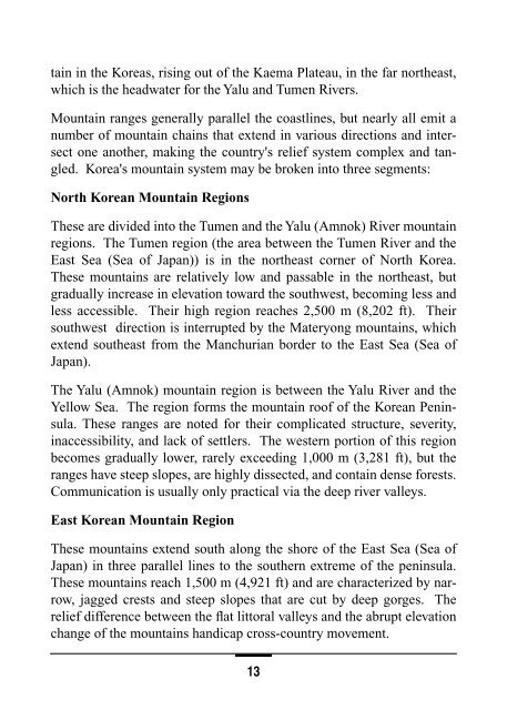
- Page 1 and 2: MCIA-2630-NK-016-97 DEPARTMENT OF D
- Page 3 and 4: MEMORANDUM FOR DISTRIBUTION SUBJECT
- Page 5 and 6: Contents (Continued) Climate . . .
- Page 7 and 8: Contents (Continued) Counterattack.
- Page 9 and 10: Contents (Continued) Division and R
- Page 11 and 12: Contents (Continued) Division 122/1
- Page 13 and 14: Contents (Continued) ZPU-4 Heavy AA
- Page 15 and 16: Contents (Continued) K-61 Tracked A
- Page 17 and 18: Contents (Continued) SOHUNG PTG . .
- Page 19 and 20: North Korea—Political and Economi
- Page 21 and 22: will likely cling to its outmoded s
- Page 23 and 24: PYONGYANG Yellow Sea South Korea Ma
- Page 25 and 26: heavy rolling stock, scarcity of he
- Page 27 and 28: Chinese characters were used before
- Page 29: ROK governments hold that the MDL i
- Page 33 and 34: Major Rivers Name Length Navigable
- Page 35 and 36: one travels. Observation in the nor
- Page 37 and 38: PUSAN, South Korea 35 o 10'N 129 o
- Page 39 and 40: TAEJON, South Korea 36 o 27'N 127 o
- Page 41 and 42: PYONGYANG, North Korea 39 o 01'N 12
- Page 43 and 44: YANGDOK, North Korea 39 o 10'N 127
- Page 45 and 46: Thunderstorms usually occur about 2
- Page 47 and 48: agents at this time, dispersion pat
- Page 49 and 50: Effects of Vegetation on Military O
- Page 51 and 52: The DPRK enforces a mandatory consc
- Page 53 and 54: The North Korean Air Force (NKAF) T
- Page 55 and 56: The transport fleet has some 1950s-
- Page 57 and 58: The DPRK's attack submarine invento
- Page 59 and 60: to hinder a CFC counterattack. Pers
- Page 61 and 62: The primary strength that the DPRK
- Page 63 and 64: 3. Overwhelming Firepower: Employ c
- Page 65 and 66: coastal, rear area, or capital defe
- Page 67 and 68: large quantities of armored personn
- Page 69 and 70: KAESONG-MUNSAN CHORWON VALLEY EAST
- Page 71 and 72: ■ Close combat fires: Designed to
- Page 73 and 74: The NKA uses two primary tactical f
- Page 75 and 76: KILOMETERS 10 8 6 4 2 0 RECON UNIT
- Page 77 and 78: NKA Attack Formation NKA combat org
- Page 79 and 80: NKA Tactical Frontages and Depths i
- Page 81 and 82:
KILOMETERS 7 6 5 4 3 2 1 0 I Regime
- Page 83 and 84:
KILOMETERS 12 11 10 9 8 7 6 5 4 3 2
- Page 85 and 86:
the main force is committed under t
- Page 87 and 88:
attack, it can also take place in t
- Page 89 and 90:
Infiltration I I Force LT (Rear Are
- Page 91 and 92:
Night Attack The NKA views night op
- Page 93 and 94:
NKA armor and infantry forces are e
- Page 95 and 96:
The combined-arms theory of the NKA
- Page 97 and 98:
The supporting artillery unit or ar
- Page 99 and 100:
Air Defense Support to Offensive Op
- Page 101 and 102:
assets at the service and national
- Page 103 and 104:
Generally, when in the defense, the
- Page 105 and 106:
deployed here. NKA reserves will be
- Page 107 and 108:
1.5 - 2.5 KM REGIMENT ARTILLERY CLO
- Page 109 and 110:
Positional Defense Positional defen
- Page 111 and 112:
KILOMETERS 10 8 6 4 2 0 Regimental
- Page 113 and 114:
Counterattack A counterattack would
- Page 115 and 116:
sions of repelling CFC attacks and
- Page 117 and 118:
Engineer Support to Defensive Opera
- Page 119 and 120:
■ Employment of land-based antish
- Page 121 and 122:
circumstances (language capabilitie
- Page 123 and 124:
Tunnel Constructed by the North Und
- Page 125 and 126:
ARMY Private Private First Class Co
- Page 127 and 128:
Winter Full Dress Uniform (Generals
- Page 129 and 130:
Captain North Korean Navy Rank Insi
- Page 131 and 132:
North Korean Air Force Rank Insigni
- Page 133 and 134:
Artillery Tanker Finance Transporta
- Page 135 and 136:
Armored Corps Forward Army Corps* 1
- Page 137 and 138:
C & S X REAR SVC X I I I I I I I I
- Page 139 and 140:
I HQ INFANTRY DIVISION T-54/55 M198
- Page 141 and 142:
HQ Infantry Battalion I INFANTRY BA
- Page 143 and 144:
I HHC Field Hospital HQ Chemical Ba
- Page 145 and 146:
I ATGM BATTALION UAZ-69 ATGM AT-1 A
- Page 147 and 148:
I Command & Control SAM (SA-3) Regi
- Page 149 and 150:
I HHC RIVER-CROSSING BRIGADE K-61 T
- Page 151 and 152:
I Command & Met SCUD BATTALION SCUD
- Page 153 and 154:
I HQ 170 170 170 170 170 170 X I I
- Page 155 and 156:
H&S Division 122/152mm Towed Artill
- Page 157 and 158:
I HQ I I ARMOR BRIGADE T-62 VTT-323
- Page 159 and 160:
RECONNAISSANCE BATTALION I HQ RECON
- Page 161 and 162:
I HQ I MECHANIZED INFANTRY BRIGADE
- Page 163 and 164:
SECTION 5 MEDICAL ASSESSMENT Key Ju
- Page 165 and 166:
Typhus. Typhus includes any of seve
- Page 167 and 168:
ness. Water and air pollution are w
- Page 169 and 170:
der are classified as highly hazard
- Page 171 and 172:
■ Keep as dry as possible. Many d
- Page 173 and 174:
APPENDIX A: Equipment Recognition B
- Page 175 and 176:
Type: BTR-60PA/PB Amphibious, armor
- Page 177 and 178:
Type: BTR-40 4-wheel drive command
- Page 179 and 180:
MODEL 531A Type: Chinese, amphibiou
- Page 181 and 182:
TYPE 85 ATGM CARRIER Type: ATGM car
- Page 183 and 184:
LINE DIAGRAM UNAVAILABLE M1992 Type
- Page 185 and 186:
TYPE-62 LIGHT TANK Type: Light tank
- Page 187 and 188:
LINE DIAGRAM UNAVAILABLE PT-85 (TYP
- Page 189 and 190:
T-54 Type: Medium tank Armament: 10
- Page 191 and 192:
TYPE-59 Type: Medium tank Armament:
- Page 193 and 194:
SU-100 Type: Assault tank Armament:
- Page 195 and 196:
M-1942 (ZIS-3) Type: Antitank gun C
- Page 197 and 198:
D-48 Type: Antitank gun Caliber: 85
- Page 199 and 200:
AT-1/SNAPPER The AT-1 is a MCLOS AT
- Page 201 and 202:
AT-4/SPIGOT The AT-4 is a SACLOS gu
- Page 203 and 204:
RPG-7 Type: 85mm warhead, 40mm laun
- Page 205 and 206:
B-10 RCL Type: 82mm smoothbore anti
- Page 207 and 208:
OTHER ARTILLERY EQUIPMENT The follo
- Page 209 and 210:
A-19 (M-1937) Type: 122mm towed gun
- Page 211 and 212:
D-20 Type: 152mm towed howitzer Max
- Page 213 and 214:
M-1978 (KOKSAN) Type: 170mm self pr
- Page 215 and 216:
BM-21 Type: 122mm multiple rocket l
- Page 217 and 218:
BMD-20 Type: 200mm multiple rocket
- Page 219 and 220:
LINE DIAGRAM UNAVAILABLE FROG-5 Typ
- Page 221 and 222:
M-38/46 DSHK Type: 12.7x108mm heavy
- Page 223 and 224:
ZPU-2 Type: 14.5x114mm twin heavy A
- Page 225 and 226:
LINE DIAGRAM UNAVAILABLE M-1983 Typ
- Page 227 and 228:
M-1939 Type: 37mm automatic cannon
- Page 229 and 230:
Type-74 Type: 37mm twin automatic c
- Page 231 and 232:
S-60 Type: 57mm automatic AA gun Ta
- Page 233 and 234:
LINE DIAGRAM UNAVAILABLE TWIN 57MM
- Page 235 and 236:
KS-19 Type: 100mm single shot AA gu
- Page 237 and 238:
SA-3 GOA The SA-3 B/C is a somewhat
- Page 239 and 240:
SA-7B The SA-7B is a short range, m
- Page 241 and 242:
SA-16 The SA-16 is an improvement o
- Page 243 and 244:
CSA-3A PGLM No data is available on
- Page 245 and 246:
TOKAREV TT-33 7.62MM PISTOL The Tok
- Page 247 and 248:
AK-47 ASSAULT RIFLE The AK-47 is a
- Page 249 and 250:
TYPE-68 (AKM) ASSAULT RIFLE The Typ
- Page 251 and 252:
PPSH 1943 SUBMACHINEGUN (TYPE-50 CH
- Page 253 and 254:
DRAGUNOV SNIPER RIFLE (SVD) The Dra
- Page 255 and 256:
RPK LIGHT MACHINEGUN The RPK is a g
- Page 257 and 258:
RP-46 LIGHT MACHINEGUN The RP-46 is
- Page 259 and 260:
DSHK 38/46 HEAVY MACHINEGUN The DSh
- Page 261 and 262:
AGS-17 AUTOMATIC GRENADE LAUNCHER T
- Page 263 and 264:
120MM M-1943 MORTAR The Soviet M-19
- Page 265 and 266:
F-1 FRAGMENTATION HAND GRENADE The
- Page 267 and 268:
RGD-5 FRAGMENTATION HAND GRENADE Th
- Page 269 and 270:
UNKNOWN FRAGMENTATION HAND GRENADE
- Page 271 and 272:
RDG-2 SMOKE HAND GRENADE The RDG-2
- Page 273 and 274:
LACRIMATORY HAND GRENADE The grenad
- Page 275 and 276:
RKG-3 ANTITANK HAND GRENADE The RKG
- Page 277 and 278:
TMD-B ANTITANK MINE The TMD-B is an
- Page 279 and 280:
TM-46 AND TMN-46 ANTITANK MINE The
- Page 281 and 282:
POMZ-2 ANTIPERSONNEL MINE The POMZ-
- Page 283 and 284:
Main Charge Propelling Charge OZM-3
- Page 285 and 286:
BTM HIGH SPEED DITCHING MACHINE The
- Page 287 and 288:
MDK-2 TRENCH DIGGING MACHINE The MD
- Page 289 and 290:
BLG-60 ARMORED VEHICLE-LAUNCHED BRI
- Page 291 and 292:
MT-55 TANK-LAUNCHED BRIDGE The MT-5
- Page 293 and 294:
GROUND TRANSPORTATION VEHICLES The
- Page 295 and 296:
UAZ-469 The Russian designed UAZ-46
- Page 297 and 298:
FIGHT 66 (TUJAENG) The Fight 66 (TU
- Page 299 and 300:
ISUZU TWD25 This 6x6 2.5 ton cargo
- Page 301 and 302:
NISSAN TZA52PP This 6x6 30 ton Japa
- Page 303 and 304:
KRAZ-260 This Russian produced vehi
- Page 305 and 306:
INDEPENDENCE 82 (CHAJU 82) The Inde
- Page 307 and 308:
ARS-12U TRUCK-MOUNTED DECONTAMINATI
- Page 309 and 310:
MODEL DP-62 LIGHTWEIGHT SURVEY METE
- Page 311 and 312:
2 1 6 8 5 7 11 9 1. Case 2. Case li
- Page 313 and 314:
MI-4 HOUND The Mi-4 is a multirole
- Page 315 and 316:
MI-17 HIP The Mi-17 has an airframe
- Page 317 and 318:
F-5 (MIG-17) FRESCO A/B/C/D The DPR
- Page 319 and 320:
MIG-21 FISHBED D/F/J The DPRK has a
- Page 321 and 322:
MIG-29 FULCRUM A/B The DPRK has abo
- Page 323 and 324:
SU-25 FROGFOOT A The DPRK has about
- Page 325 and 326:
Y-5 (AN-2 COLT) The DPRK has about
- Page 327 and 328:
IL-18 COOT The DPRK has 2 of these
- Page 329 and 330:
BAR LOCK Name: P-35/37 Type: EW Fre
- Page 331 and 332:
FLAT FACE Name: P-15 Type: EW/ACQ F
- Page 333 and 334:
LOW BLOW Type: FC Trk/FC Guid Freqe
- Page 335 and 336:
SPOON REST A/C/D Name: P-12 Type: A
- Page 337 and 338:
TALL KING Name: P-14 Type: BW Freqe
- Page 339 and 340:
LINE DIAGRAM UNAVAILABLE SOHO FF LO
- Page 341 and 342:
d.c. 25mm 53cm TT (pt, stbd) Radar
- Page 343 and 344:
CHAHO PB LOA/Beam/Draft: 85.3x19x6.
- Page 345 and 346:
Ammo housing/ loading ramp for MRL
- Page 347 and 348:
37mm 37mm MGs (pt, stbd) K-48 PC LO
- Page 349 and 350:
37mm 25mm (pt, stbd) Latticed tripo
- Page 351 and 352:
LINE DIAGRAM UNAVAILABLE MAYANG PG
- Page 353 and 354:
14.5mm Folding mast 14.5cm (pt, stb
- Page 355 and 356:
14.5mm 53cm TT (pt, stbd) Folding m
- Page 357 and 358:
Latticed tripod mast 88mm (pt, stbd
- Page 359 and 360:
SSM (pt, stbd) Tripod mast SOHUNG P
- Page 361 and 362:
14.5mm (to stbd) Latticed mast NAMP
- Page 363 and 364:
LINE DIAGRAM UNAVAILABLE HANTAE LCU
- Page 365 and 366:
ROMEO SS LOA/Beam/Draft: 252x23x20
- Page 367 and 368:
THE NAVAL MINE THREAT TO AMPHIBIOUS
- Page 369 and 370:
PDM-1M SHALLOW WATER MINE The PDM-1
- Page 371 and 372:
CSS-N-1 SCRUBBRUSH The CSS-N-1 is t
- Page 373 and 374:
CSSC-3 SEERSUCKER The Chinese SEERS
- Page 375 and 376:
APPENDIX C: Conversion Charts When
- Page 377 and 378:
Heat Wave A Hot Summer Day A Warm W
- Page 379 and 380:
Vowels a-father = a a-had = ae ya-y
- Page 381 and 382:
Questions What is your name? ee-rum
- Page 383 and 384:
Do you have weapons? moo-gee ee-so-
- Page 385 and 386:
Food/Shelter What food is there? mo
- Page 387 and 388:
Air Force kong-goon Alley gol-mok A
- Page 389 and 390:
Crash (aircraft) choo-rak-hae-yo Cu
- Page 391 and 392:
Height no-pee Help do-oom Here yo-g
- Page 393 and 394:
Name ee-rum Navy hae-goon NCO ha-sa
- Page 395 and 396:
Sign pyo-jee/gan-pan Sink chim-mol-
- Page 397 and 398:
Why we Width nol-bee Woman yo-ja Ya
- Page 399 and 400:
APPENDIX E: Individual Protective M
- Page 401 and 402:
■ ■ ■ ■ ■ ■ ■ ■ Do
- Page 403 and 404:
Protective Measures Against the For
- Page 405 and 406:
■ ■ ■ current I.D. card must
- Page 407 and 408:
APPENDIX F: FIRST AID/HOT AND COLD
- Page 409 and 410:
Arm-Lift Method. If mouth to mouth
- Page 411 and 412:
BLEEDING External bleeding falls in
- Page 413 and 414:
6. Have the casualty lie on the inj
- Page 415 and 416:
10. Splint fractures of the lower a
- Page 417 and 418:
■ Do not allow your thirst to be
- Page 419 and 420:
WIND SPEED KNOTS MPH TEMPERATURE (
- Page 421 and 422:
increased warmth, and a sensation o
- Page 423 and 424:
■ Drink plenty of fluids, at leas
- Page 425 and 426:
many other factors. The normal reac
- Page 427 and 428:
the frozen part - MEDEVAC immediate
- Page 429:
FOR OFFICIAL USE ONLY FOR OFFICIAL


