Milestones
The story of a milestone by the road side
The story of a milestone by the road side

You also want an ePaper? Increase the reach of your titles
YUMPU automatically turns print PDFs into web optimized ePapers that Google loves.
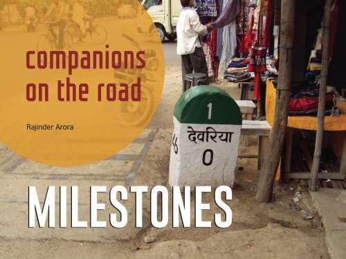
companions<br />
on the road<br />
Rajinder Arora<br />
MILESTONES
One of the finest<br />
references to<br />
milestones also<br />
appears in Asterix<br />
and the Chariot<br />
Race. And<br />
herebelow Obelix<br />
is chiseling by a<br />
menhir describing<br />
the condition of<br />
roads leading to<br />
Rome.<br />
The Milliarium Aureum (above), or the Golden Milestone (Italian: Miliario Aureo) was a monument,<br />
probably of marble or gilded bronze, erected by the Emperor Caesar Augustus near the Temple of<br />
Saturn in the Central Forum of Ancient Rome. All roads were considered to begin at this monument and<br />
all distances in the Roman Empire were measured relative to it. On it, perhaps, were listed all the major<br />
cities in the empire and distances to them, though the monument’s precise location and inscription<br />
remain matters of debate among historians. Wikipedia<br />
© Astreix Comic series<br />
2
ilestones were originally stone obelisks –<br />
made from granite, marble, or other<br />
Mlocally available stone – and later these<br />
were made as concrete posts. These were widely<br />
used by Roman Empire road builders and were an<br />
important part of any Roman road network: the<br />
distance travelled per day was only a few miles in<br />
some cases.<br />
Many Roman milestones only record the name of<br />
the reigning emperor without giving any place<br />
names or distances. The first Roman milestones<br />
appeared on the Appian way. At the centre of<br />
Rome, the “Golden Milestone” was erected to<br />
mark the presumed centre of the empire: this<br />
milestone has since been lost. From approx 123<br />
BC, milestones were erected every 1000 paces<br />
(known as the Roman mile). As the road network<br />
expanded, man started to travel for trade, for<br />
exploration and for learning and in this pursuit a<br />
milestone provided much needed reassurance to<br />
the travelers that they are moving in right path<br />
and direction with fixed idea of reaching a certain<br />
place in fixed time, meeting people on the way,<br />
making friends and trade-partners. These<br />
milestones are a tribute to our history when maps<br />
were rare and the only mode of transport was<br />
either by foot or on horse-back.<br />
Roman milestone XXIX on Via Romana XVIII – the road linking the Iberian cities<br />
of Bracara Augusta and Asturica Augusta.<br />
markers<br />
of<br />
history laxehy 3<br />
<strong>Milestones</strong> have a fascinating history to tell.
You can safely say that the history<br />
of roads (and thus history of the<br />
direction/distance markers) is as<br />
old as the history of man on earth. The<br />
pre-historic group of men would have<br />
carved a narrow way by constantly<br />
going in a certain direction, to hunt for<br />
food. Many a times they would have lost<br />
their way because of not being able to<br />
come back in day light, or the rain and<br />
storm could have destroyed their foot<br />
prints, or sheer depletion of light would<br />
not let them recognise other signs of<br />
getting back to their caves. This is when<br />
the ancient man started marking trees,<br />
etching boulders enroute or leaving<br />
other physical signs to trace their way<br />
back home. In hilly and high altitude<br />
mountainous region, even today, we find<br />
‘cairns’ as the direction markers over<br />
several routes. These were all precursor<br />
to milestones of modern times. [Cairns<br />
are carefully placed piles of rocks built<br />
by mountain travellers or trail guides to<br />
mark trails and help hikers each the<br />
desired destination].<br />
The initial narrow way was a footpath or<br />
pathway. This rough pathway can be<br />
considered as the first road marks. The<br />
utility and necessity of pathway must<br />
have gradually developed with the<br />
coming of wheeled carts. These<br />
pathway must have been widened into a<br />
roadway which was the beginning of<br />
road as a means of travel, exploration,<br />
communication and transport.<br />
Road development in the Indian<br />
subcontinent can be traced back to<br />
approximately 2800 BC from the<br />
ancient cities of Harrapa and<br />
Mohenjodaro of the Indus Valley<br />
Civilization which had a well designed<br />
network of ‘paved’ streets, pathways<br />
and roads. Ruling emperors of ancient<br />
India had constructed roads to connect<br />
the towns and cities. The Rig Veda<br />
mentions ‘Mahapaths’ as a means of<br />
communication during the Aryan<br />
period.<br />
4<br />
King Ashoka (riding a cahriot) visits Ramagrama, to take relics of the Buddha from the Nagas, but in vain. Southern gateway, Stupa 1, Sanchi. Photo: Wikipedia.
A ‘pucca road’ was built in Rajgir town built roads, and alongside these roads <strong>Milestones</strong> are installed to provide<br />
of Patna district in Bihar by king were places for night halts, provision for reference points along the road. This<br />
Bimbisara in 600 B.C. This road was 6 to cooking, source of water and stables for can be used to reassure travellers that<br />
7 m wide and was made of stones. The horses. Some of these charged the the proper path is being followed, and<br />
road exists till date. travellers for their stay. These places to indicate the remaining distance to a<br />
called caravan-sarais, were also used as destination. Such references are also<br />
In the record of his travel, the famous watch towers and information gathering used by road maintenance staff and<br />
Chinese traveler, Fahien speaks very points for the kings men. Fruit trees emergency services to direct them to<br />
highly of the roads in India during the were planted along these roads and specific points where their presence is<br />
time of Emperor Ashoka of Maurayn over a period of time the keepers of required. This term is sometimes used<br />
Dynasty (3rd century BC). If we look a these sarais also started growing to denote a location on a road even if<br />
the archeological evidence of that era vegetables and grain around them. no physical sign is present. This is<br />
we are sure that chariots were very Along these caravan-sarais tall imposing useful for accident reporting and other<br />
common in that period which confirms structures called Kos Minars were built. record keeping (e.g., “an accident<br />
that there must have been cobbled or These Minars where made at fixed occurred at the 13 mile mark” even if<br />
paved roads to run these chariots. distance of 3 kos, or 2 kms. These were the road is only marked with a stone<br />
the first milestones of India.<br />
once every 10 miles). In the city of<br />
While there were roads going in all<br />
Gurgaon in Haryana, a particular<br />
directions to various towns ruled by A milestone is one of a series of highway restaurant is popularly known<br />
these empires, there was no signage numbered stones placed along a road as 32nd Milestone.<br />
indicating the town they were going to at intervals of one mile or multiple of<br />
or the distance between any two points. miles. They are typically located at the The historical term milestone is still<br />
The Roman empire was presumably the side of the road. Some of these also used today, even though the “stones”<br />
first one to use large obelisks marking have another number painted on the are typically metal highway location<br />
direction, distance and the names of side which indicates their number in a markers and in most countries use<br />
towns/cities. series on that road. They are kilometres and metres rather miles and<br />
alternatively known as mile markers,<br />
In the Indian sub-continent, milestones mileposts, mile posts of miliarium.<br />
were introduced by the earliest Mughals Mileage is the distance along the road<br />
traveling from the Central-Asian Great from a fixed commencement point.<br />
Steppes through Afghanistan and<br />
<strong>Milestones</strong> were originally stone<br />
entering India having crossed the Indus obelisks – made from granite, marble,<br />
river. Mughal warriors were great at or whatever local stone was available<br />
horse riding and travelled long distance without any inscriptions – and later<br />
every day. Having settled in India they concrete posts.<br />
5
yards. Also found today are similar with bricks and plastered over with the<br />
looking signs indicating the position of lime. Though not architecturally very Mediterranean.<br />
buried high voltage cables and even impressive, they were an important Christian in<br />
compressed natural gas pipes. part of communication and travel in a nature, it was<br />
large empire.<br />
perennially at<br />
Roman Empire<br />
war with the<br />
<strong>Milestones</strong> were widely used by Kos is an ancient Indian unit of Muslims,<br />
Roman Empire road builders and were distance. It can represent either a Flourishing<br />
an important part of any Roman road distance of approximately 1.8 during the reign<br />
network though the distance travelled kilometres (1.1 mi) or 3.2 kilometres of the<br />
per day was only a few miles in some (2.0 mi). Minar is a Persian word for Macedonian<br />
cases. Many Roman milestones only tower. Abul Fazl recorded in Akbar emperors, its<br />
record the name of the reigning Nama that in the year 1575 AD, Akbar demise was the consequence of<br />
emperor without giving any place- issued an order that at every kos on attacks by Seljuk Turks, Crusaders, and<br />
names or distances. The first Roman the way from Agra to Ajmer, a pillar or Ottoman Turks.<br />
milestones appeared on the Appian a minar should be erected for the<br />
Way. At the centre of Rome, the comfort of the travelers. Post-Medieval Europe<br />
“Golden Milestone” was erected to<br />
The British built many milestones on<br />
mark the presumed centre of the Byzantine Empire<br />
the island of Malta. They consisted of<br />
empire: the original milestone has A mile-marker monument, the Milion, large slabs of local hard rock and were<br />
since been lost.<br />
was erected in the early 4th Century engraved with the distance to or from<br />
AD in Constantinople. It served as the a particular location. Many of these<br />
India<br />
starting point for measurement of were defaced in World War II to<br />
The Kos Minars (Mughal milestones) or distances for all the roads leading to disorientate forces in a potential<br />
Mile Pillars are medieval milestones the cities of the Byzantine Empire, and invasion.<br />
that were ordered to be erected by had the same function as the<br />
the 16th-century Afghan Ruler Sher Milliarium Aureum of Ancient Rome. In the USA<br />
Shah Suri and later added to by other The Milion survived intact until at least The Golden Milestone of Rome<br />
Mughal emperors. These Minars were the late 15th century. Its fragments inspired the Zero Milestone in<br />
erected on main highways across the were discovered again in the late Washington, D.C., intended as the<br />
empire to mark the distance. 1960s. point from which all road distances in<br />
the United States should be reckoned.<br />
A Kos Minar is a solid round pillar, The Byzantine Empire was the Odometers were used to measure the<br />
around 30 feet (9.1 m) in height that continuation of the Roman Empire in Roman milestone spacing, most likely<br />
stands on a masonry platform built the Greek-speaking, eastern part of based on Ancient Greek Technology.<br />
6
While stepping out of the house today, when there no means of transport besides direction and getting closer to their<br />
how assured you feel, weather on a drive being on foot or probably riding a horse destination with every step. These markers<br />
around your own city or on a long inter- cart, when travel was fraught with danger or solitary sentinels around mud tracks<br />
state drive with a GPS installed in your car of being looted or killed by thugs, the were called milestones, sangmeel or<br />
or connected to Google Maps guiding you danger of ferocious animals, when there meelpathar.<br />
through the journey; which road to take, no places for night halts, not even a<br />
The word Sangmeel is a Persian conjoined<br />
where to turn and keep on the right<br />
chance of finding food or water enroute,<br />
word. Sang means stone and Meel is the<br />
course to reach your destination. Not just when the evening or night meant to stop,<br />
measure of distance. Thus Sangmeel<br />
the road, today we even have the luxury of climb a tree or hide in a cave, if at<br />
means milestone. Like Sang-marmar, the<br />
knowing how far is the next petrol pump or all...when there were no street lights but<br />
smooth, or soft silky stone, and similarly<br />
a way side eatery, a washroom or a place for the moonlight and the guiding stars,<br />
the Hindi word Meel Pathar.<br />
to relax or spend the night.<br />
only if you knew how to read them.<br />
If you find any old milestones along the<br />
But think of the times when the GPS or And of course, there were no road signs.<br />
road side, please stop and look at them,<br />
digital way-finders where not around, of But more than 2200 years back there were<br />
admire them, think of the people who<br />
the times when even the physical paper some parts of the world where, markers by<br />
thought of placing or erecting them at<br />
maps were also not mass produced and the side of the road, reassured travellers<br />
designated points only to help and assure<br />
were rare, when roads were not paved, that they were heading in the right<br />
you that you are on the right path.<br />
COLOUR CODES FOR MILESTONES ON INDIAN HIGHWAYS/ROADS<br />
NATIONAL HIGHWAY<br />
STATE HIGHWAY<br />
CITY ROADS<br />
RURAL ROADS<br />
YELLOW<br />
GREEN<br />
BLACK<br />
ORANGE<br />
NH 8<br />
10<br />
fnYyh<br />
112<br />
DELHI<br />
iq.ks<br />
87<br />
PUNE<br />
jksfg.kh<br />
9<br />
ROHINI<br />
lho.k<br />
5<br />
SIVAN<br />
7
8<br />
A Kos Minar outside the Delhi Zoo and facing Purana Qila.
Kos Minar<br />
dksl ehukj<br />
Much before the milestones were used on pucca<br />
carried the name of area they were built in. Over the<br />
/tarred roads in Asia, imposing and tall structures<br />
years most of the Kos Minars have fallen to vagaries of<br />
called Kos Minars were seen in India. The Kos Minars or weather and development or have been destroyed by<br />
Mile Pillars are medieval milestones that were made by land grabbers. However, recent efforts by the<br />
the 16th-century Afghan Ruler Sher Shah Suri and later archeological department has ensured that some of<br />
on added by Mughal emperors.<br />
these have been restored and are now protected<br />
monuments both in India and Pakistan.<br />
Sher Shah Suri had them built on one of Grand Trunk<br />
Road (GT Road), from Chittagong (now in Bangladesh) Kos is an ancient Indian unit of distance. It can<br />
to Kabul in Afghanistan, the earliest and longest well- represent either a distance of approximately 1.8<br />
organised road in Asia (can be called a highway in<br />
kilometres (1.1 mi) or 3.2 kilometres (2.0 mi). Minar is a<br />
contemporary times) which linked Indian subcontinent Persian word for tower. Abul Fazl recorded in Akbar<br />
with other Asian countries.<br />
Nama that in the year 1575 AD, Akbar issued an order<br />
that at every Kos on the way from Agra to Ajmer, a pillar<br />
The length of GT Road is approx 2,500 km. Kos Minars or a minar should be erected for the comfort of the<br />
were erected by the Mughal Emperors on the main travelers.<br />
highways across the empire to mark the distance.<br />
Around these Minars were also the Caravan Sarais and<br />
stables for horses. A Kos Minar is a solid round pillar,<br />
around 30 feet (9.1 m) high with a bottom<br />
circumference of about 4 mt that stands on a masonry<br />
platform built with bricks and plastered over with lime.<br />
Though not architecturally very impressive, being<br />
milestones, they were an important part of<br />
communication and travel in a large empire. Some of<br />
these Minars also carried the names of the ruling kings, A Kos Minar on<br />
and the year they were built in while some others<br />
Agra highway<br />
9
A road sign on Mall Road (part of Grand Trunk Road)<br />
in Rawalpindi, Pakistan<br />
A Kos Minar<br />
on GT Road<br />
in Punjab<br />
A Kos Minar<br />
along GT Road<br />
at Taraori in<br />
Karnal, Haryana<br />
10
Part of the original 16th Century cobbled GT Road in Kabul, Afghanistan with portion of the Kos Minar<br />
11
<strong>Milestones</strong> on Delhi-Lahore Grand Trunk Road<br />
These pre-Independence era milestones on GT Road between<br />
Delhi and Lahore still exist at a few locations between Delhi and<br />
Lahore. One each is known to have survived in Delhi, Ludhiana,<br />
Ferozepur, Amritsar and Lahore.<br />
12
Some old Indian milestones<br />
Located at a tri-junction and next to the MPTDC Tourist<br />
Lodge in Piparia, this milestone has inscriptions on<br />
three of the four faces. The inscriptions are on arched<br />
marbele plaques and record distance in miles and<br />
heights in feats. The milestone looks more like a<br />
miniature temple and has inscriptions on three side.<br />
The inscription is on arched marble plaques. Two sides<br />
contains distances in miles from nearby destinations.<br />
The third side contains names of places along with<br />
their altitude in feet.<br />
13
Zero Mile Stones<br />
Zero Mile Stones are those<br />
milestones in a city from<br />
where all further distances<br />
are measured. For<br />
example, the Zero<br />
milestone in Delhi (below)<br />
is at Rajghat, the place<br />
where Mahatma Gandhi’s<br />
samadhi is there. It is from<br />
this point in Delhi that all<br />
distance going in different<br />
directions are measure<br />
and given. Similarly when<br />
you are coming in to Delhi,<br />
the distance given on<br />
various milestones are<br />
given up to this point.<br />
The Zero Mile Stone in<br />
Nagpur, Maharashtra is a<br />
monument built by the<br />
British during Great<br />
Trigonometrical Survey of<br />
India in 1907. The Zero Mile<br />
Stone pillar is made of<br />
sandstone and another<br />
small stone representing<br />
the GTS Standard Bench<br />
Mark. The four stucco<br />
horses next to it were<br />
added later. Contrary to the<br />
popular belief, there is no<br />
verifiable evidence that it is<br />
a monument locating the<br />
geographical centre of<br />
colonial India or that the<br />
Zero Mile Stone was erected<br />
by the British to use this<br />
point to measure all the<br />
distances.<br />
14
Hertiage lost and found<br />
<strong>Milestones</strong> of British era<br />
recently found in Mumbai<br />
Workers of the Brihanmumbai<br />
Municipal Corporation<br />
recently found and restored<br />
British era milestones around<br />
Parel area. These milestones<br />
are of pre-motored vehicles<br />
times and are a part of<br />
Mumbai’s heritage.<br />
The '0' milestone was located<br />
at St Thomas Cathedral at<br />
Horniman Circle. Five<br />
milestones were located<br />
nearly buried in the footpath.<br />
A Mumbai resident, Vinayak<br />
Talwar, stands beside the V<br />
milestone located inside<br />
Colaba’s Badhwar Park Colony<br />
15
16<br />
Some ancient milestones from other parts of the world
Children helping restore a heritage milestone in<br />
England. A great way of learning your past.<br />
17
Distance / territory markers – unlike milestones<br />
Boundary or distance markers for Bhutan, Myanmar and<br />
Bangladesh<br />
Distance and<br />
altitude marker<br />
built by BRO<br />
18
Road signs in 21st Century<br />
Traditional style milestones are fast<br />
vanishing. With the expansion of road<br />
network and multi-lane highways a new style<br />
of distance indicators are evolving in the<br />
form of Gantries. These are large overhead<br />
signs, placed high above the road, in direct<br />
gaze of the driver so these can be seen<br />
from a distance. These are visible even at<br />
night as they are made of reflective colour<br />
film which doesn’t need external source of<br />
lighting. Multiple languages on these help<br />
local drivers identify their route easily.<br />
19
20<br />
<strong>Milestones</strong> from various parts of the country
Though these markers are called milestones, the distance given on them is in kilometeres and not miles.<br />
21
22
Check these out<br />
By the side of a road but not alone<br />
23
These signs along the roads These are Umling La (19,300 ft); Dungri La, also known<br />
are technically not milestones as Mana Pass (18,406 ft); Khardung La (17,882 ft)<br />
but they serve an equally [wrongly mentioned as 18,380 ft and also as the<br />
Humorous good purpose of breaking the Highest motorable pass]; Tanglang La (17,480 ft) and<br />
Road Signs monotony of long tiresome Chang La (17,586 ft). ‘La’ means a mountain pass. The<br />
by BRO<br />
journey through the desolate, hardy men of BRO quickly clear landslides, avalanches<br />
barren, dangerous and<br />
and snow block on the routes maintained by them and<br />
sometime desolate areas of facilitate uninterrupted movement of traffic in all<br />
the Indian Himalayas.<br />
weathers. Border Road Organisation has its own<br />
construction wing known as Road Construction<br />
Reading these hilarious and Companies (RCCs). The BRO also played a vital role in<br />
thought provoking signs provide much needed caution reconstruction work in the aftermath of the devastating<br />
and relief while driving on treacherous stretches. Some 2004 tsunami in Tamil Nadu, the 2005 Kashmir<br />
of these depict great sense of humour.<br />
earthquake, and the 2010 Ladakh flash floods.<br />
Roads in hilly, mountainous and also dense jungle<br />
regions of India, specially around Indian borders with<br />
countries, like China, Nepal, Pakistan, Mayanmar,<br />
Bhutan and Bangladesh are mostly maintained by<br />
Border Road Organisation (BRO) through General<br />
Reserve Engineering Force of the Indian Army. These<br />
signs, erected by BRO, not only add colour to the<br />
muted surroundings but also send an alert signal to<br />
weary drivers. The BRO manages its jobs through its<br />
Task Forces, mentioned on these signs as TF.<br />
753 Task Force<br />
Altitude or height from<br />
Mean Sea Level<br />
51 Road Construction<br />
Company<br />
Some of these Task Forces are named as Arunank,<br />
Beacon, Brahmank, Chetak etc. The BRO operates and<br />
maintains thousands of kilometres of roads, bridges,<br />
tunnels and many an airfields in the country. In India,<br />
some of the roads run-over the highest motorable<br />
mountain passes in the world.<br />
24
25
High mountain pass signs in the Himalayas<br />
In India, some of the roads run over the highest motorable mountain passes in the world.<br />
Umling La (19,300 ft); Dungri La or Mana Pass (18,406 ft); Khardung La (17,882 ft)<br />
[wrongly mentioned as 18,380 ft and also as the highest motorable pass); Tanglang La<br />
(17,480 ft) and Chang La (17,586 ft). A La means a mountain Pass.<br />
26
ut then<br />
‘Life isn’t a matter of milestones,<br />
but of moments’<br />
Rose Kennedy<br />
‘Justice ∞ (infinte) km’, a<br />
milestone used as a prop<br />
by Lakshya, theatre group<br />
of Kamla Nehru College,<br />
Delhi while performing the<br />
play Justice Abhi Far Hai<br />
at JNU in Delhi, as a<br />
tribute to Safdar Hashmi.<br />
BUSINESS AS USUAL<br />
BY UNNY<br />
Dharavi in Mumbai is possibly<br />
the largest slum in the world.<br />
The milestone here proudly<br />
displays what it is known for.<br />
April 2018<br />
Renowned cartoonist Unny<br />
uses a milestone as a mark<br />
of respect to those killed in<br />
Gujarat violence in 2002<br />
after the Supreme Court<br />
acquitted all suspects.<br />
The message<br />
a milestone<br />
gives is that<br />
you are<br />
never alone.<br />
27
A war destroys everything in its path, even a milestone has to bear its brunt. Look at this bullet ridden<br />
milestone (left) after the 1965 India-Pakistan war. “Lahore 14.2 Bloody Miles” The word Bloody here is<br />
actually painted in red. The one on right is of the same period in Khemkaran sector of Punjab which saw<br />
one of the fiercest tank battle.<br />
28<br />
The last milestone in Jammu,<br />
at the India-Pakistan border.<br />
Asia Highway 1 (AH1) milestone on India-Pakistan border at Wagha,<br />
Panjab. AH1 is the longest route of the Asian Highway Network, running<br />
20,557 km from Tokyo, Japan to the west of Istanbul where it joins with<br />
European route E80.
One of the<br />
largest<br />
milestones in<br />
the world is<br />
in Ecuador<br />
marking the<br />
line of<br />
Equator,<br />
Latitude<br />
0-0-0,<br />
Above: Pole marker at North Pole, Arctic.<br />
Below: the one at South Pole, Antarctic.<br />
On the right is<br />
the milestone<br />
plaque on 45th<br />
Parallel which<br />
is equidistant<br />
from North<br />
Pole and the<br />
Equator<br />
Trust me, even if you want you cannot lose your way here. This sign<br />
(not a milestone) is less than 5km before the Everest Base Camp<br />
(see Mt Everest in the backdrop). There is no other track you can<br />
follow but the semi-glacial boulder strewn wilderness to the base of<br />
the peak at Khumbu Glacier at 17,600 feet.<br />
Popularly known as<br />
White Desert, the<br />
stunning white<br />
sands of the Great<br />
Rann of Kuchh is a<br />
salt marsh located<br />
in Kuchh district of<br />
Gujarat. It is a part<br />
of the Thar Desert,<br />
just 6km from the<br />
village of Dhordo.<br />
29
Road expansion, repair and unregulated carpeting of<br />
roads, heaps upon heaps of more and more bitumen<br />
over the existing surface is not only raising the road<br />
levels in all cities but is also eating up the heritage<br />
structures and milestones in the process. The so called<br />
development and encroachment of road or footpath<br />
spaces is yet another reason where encroachers uproot<br />
the milestones and use the space to set up shacks<br />
along road sides.<br />
Look at the picture of this Chennai Zero milestone<br />
which is slowly being swallowed by the rising level of<br />
road. In less than a decade only one fifth of the<br />
milestone is left visible. In the last picture don't miss the<br />
height of the pavement which is most difficult to climb<br />
even by youngsters, for the elderly or the infirm it is<br />
impossible to step on to this 14 inch high pavement.<br />
Language row: Bearing the brunt of ‘language<br />
supremacy fight’, milestones and local sign boards have<br />
come under severe defacement and destruction at the<br />
hands of people who are contesting the use of their<br />
local language vis-vis the imposition of Hindi in non-<br />
Hindi speaking areas. Rightfully so, the milestones and<br />
signs must carry the local language first and then<br />
English and/or Hindi for the benefit of other people.<br />
30
An Ode to Terminus<br />
(the God of boundary stones - in turn milestones)<br />
When night has passed, let the god be celebrated<br />
With customary honour, who separates the fields with his sign.<br />
Terminus, whether a stone or a stump buried in the earth,<br />
You have been a god since ancient times.<br />
You are crowned from either side by two landowners,<br />
Who bring two garlands and two cakes in offering.<br />
An altar’s made: here the farmer’s wife herself<br />
Brings coals from the warm hearth on a broken pot.<br />
The old man cuts wood and piles the logs with skill,<br />
And works at setting branches in the solid earth.<br />
Then he nurses the first flames with dry bark,<br />
While a boy stands by and holds the wide basket.<br />
When he’s thrown grain three times into the fire<br />
The little daughter offers the sliced honeycombs.<br />
Others carry wine: part of each is offered to the flames:<br />
The crowd, dressed in white, watch silently.<br />
Terminus, at the boundary, is sprinkled with lamb’s blood,<br />
And doesn’t grumble when a sucking pig is granted him.<br />
Neighbours gather sincerely, and hold a feast,<br />
And sing your praises, sacred Terminus:<br />
‘You set bounds to peoples, cities, great kingdoms:<br />
Without you every field would be disputed.<br />
You curry no favour: you aren't bribed with gold,<br />
Guarding the land entrusted to you in good faith.<br />
If you'd once marked the bounds of Thyrean lands,<br />
Three hundred men would not have died,<br />
Nor Othryades' name be seen on the pile of weapons.<br />
O how he made his fatherland bleed!<br />
What happened when the new Capitol was built?<br />
The whole throng of gods yielded to Jupiter and made room:<br />
But as the ancients tell, Terminus remained in the shrine.<br />
From Fasti – book II by Ovid, the Roman poet 43 BCE<br />
‘The Feast Before the Altar of Terminus’ an engraving by Giovanni<br />
Benedetto Castiglione (1609–1644), the Italian Baroque artist,<br />
painter, printmaker and draftsman best known now for his<br />
elaborate engravings.<br />
Terminus (on the pedastal) is the god of boundary<br />
stones and markers (in turn milestones). According to<br />
a Roman tradition, a new temple was being built to<br />
Jupiter on land dedicated to several gods and<br />
goddesses. Terminus and Iuventas were the only<br />
ones who refused to vacate the site. His statue was<br />
merely a stone or post stuck in the ground to<br />
distinguish between properties.<br />
31
8<br />
DELHI<br />
KABUL<br />
Almost all pictures used in this not-forprofit<br />
book have been taken from<br />
various web sites or blog pages. The<br />
editor/author DOES NOT claim any<br />
rights to these and the copyright to<br />
these belong to respective owner/<br />
photographers. Indebted to one and all<br />
who found it important to photo a<br />
milestone as a memory of their journey<br />
or a documentation of these silent<br />
sentinels.