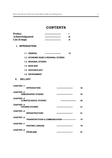
CONTENTS - Bellary District
CONTENTS - Bellary District
CONTENTS - Bellary District

You also want an ePaper? Increase the reach of your titles
YUMPU automatically turns print PDFs into web optimized ePapers that Google loves.
Master Plan (Revision-I)-2021 (Provisional) <strong>Bellary</strong>-Sandur Llocal Planning Area<br />
<strong>CONTENTS</strong><br />
Preface -------------------------- I<br />
Acknowledgement -------------------------- III<br />
List of maps -------------------------- IV<br />
I. INTRODUCTION<br />
II. BELLARY<br />
CHAPTER –1.<br />
1.1 GENERAL -------------------------- 12<br />
1.2 ECONOMIC BASE & REGIONAL STUDIES<br />
1.3 REGIONAL STUDIES<br />
1.4 BASE MAP<br />
1.5 ARCHAEOLOGY<br />
1.6 ENVIRONMENT<br />
INTRODUCTION -------------------------- 42<br />
CHAPTER –2<br />
DEMOGRAPHIC STUDIES -------------------------- 44<br />
CHAPTER –3<br />
CLIMATOLOGICAL STUDIES ------------------------- 50<br />
CHAPTER –4.<br />
HOUSING STUDIES -------------------------- 51<br />
CHAPTER –5.<br />
CHAPTER –6.<br />
CHAPTER –7<br />
CHAPTER –8<br />
INFRASTRUCTURE -------------------------- 61<br />
TRANSPORTATION & COMMUNICATION ---------------------- 74<br />
EXISTING LANDUSE -------------------------- 78<br />
PROBLEMS -------------------------- 81<br />
1
Master Plan (Revision-I)-2021 (Provisional) <strong>Bellary</strong>-Sandur Llocal Planning Area<br />
CHAPTER –9<br />
CHAPTER –10<br />
III SANDUR<br />
CHAPTER –1.<br />
PROPOSALS LANDUSE -------------------------- 84<br />
LIST OF CHANGE OF LAND USE -------------------------- 88<br />
INTRODUCTION -------------------------- 92<br />
CHAPTER –2.<br />
DEMOGRAPHIC STUDIES -------------------------- 94<br />
CHAPTER –3.<br />
CLIMATOLOGICAL STUDIES -------------------------- 99<br />
CHAPTER –4.<br />
HOUSING STUDIES ------------------------- 100<br />
CHAPTER –5.<br />
CHAPTER –6.<br />
CHAPTER –7<br />
CHAPTER –8.<br />
CHAPTER –9<br />
INFRASTRUCTURE -------------------------- 104<br />
TRANSPORTATION & COMMUNICATION ---------------------- 108<br />
EXISTING LANDUSE - 2006 -------------------------- 109<br />
PROBLEMS -------------------------- 111<br />
PROPOSALS -------------------------- 114<br />
CHAPTER –10<br />
LIST OF CHANGE OF LAND USE -------------------------- 118<br />
IV.KUDITINI & TORANAGALLU<br />
CHAPTER –1.<br />
CHAPTER –2.<br />
CHAPTER –3.<br />
INTRODUCTION -------------------------- 119<br />
POPULATION PROJECTION -------------------------- 121<br />
INFRASTRUCTURE ------------------------- 131<br />
2
Master Plan (Revision-I)-2021 (Provisional) <strong>Bellary</strong>-Sandur Llocal Planning Area<br />
CHAPTER –4.<br />
CHAPTER –5.<br />
CHAPTER –6.<br />
STRATEGY FOR DEVELOPMENT -------------------------- 132<br />
KUDITINI -------------------------- 133<br />
TORANAGALLU -------------------------- 140<br />
V. IMPLEMENTATION --------------- 150<br />
VI. PHASING AND FINANCE -------------------------- 152<br />
ZONAL REGULATIONS -------------------------- 158<br />
ANNEXURE -------------------------- 202<br />
3
Master Plan (Revision-I)-2021 (Provisional) <strong>Bellary</strong>-Sandur Llocal Planning Area<br />
1.1 GENERAL<br />
a. Local Planning Area<br />
The local planning area for erstwhile Vijayanagar Steel Planning Authority was<br />
declared vide G.O.No:HMA/156/71 dated 11/5/1971 under section 4(a) of<br />
Karnataka Town and Country Planning Act 1961 on 27/4/1973 the planning area<br />
comprised of about 1080 Sq.Km. The outline development plan for Vijayanagar<br />
Steel Planning area has been approved by Govt. vide G.O.No:HD/30/TTP/84,<br />
dated 24/02/1984.<br />
The <strong>Bellary</strong> Urban Development Authority started functioning with effect from<br />
18/6/1988, subsequently <strong>Bellary</strong> Urban Development Authority prepared a<br />
Comprehensive development plan for Vijayanagar Steel Planning Area. Govt. has<br />
accorded approval Vide G.O.No:Vanae/S24/TTP/92, dated 9/10/1995.<br />
Subsequent to this under sec.4 (a) (3) of KTCP act 1961 Government bifurcated<br />
Vijayanagar Steel Planning Area in to two. Vide notification No:<br />
VaNaEe/164/TTP/93, dated 27/7/1993 namely.<br />
i) <strong>Bellary</strong>-Sandur local planning area comprising of 17 villages of <strong>Bellary</strong> taluk<br />
and 27 villages of Sandur.<br />
ii) Hospet local Planning area comprising of 38 villages of Hospet taluk.<br />
Consequently Government under section 3(1) of Karnataka Urban Development<br />
Authority Act-1987 it constituted Hospet Urban Development Authority for Hospet<br />
local planning area vide Notification No: VaNaEe/164/TTP/93 dated 21/5/1996.<br />
4
Master Plan (Revision-I)-2021 (Provisional) <strong>Bellary</strong>-Sandur Llocal Planning Area<br />
List of Villages included in the BELLARY-SANDUR LOCAL PLANNING AREA is<br />
given in the table below.<br />
Table – 1<br />
Sl.<br />
No<br />
Name of the village<br />
/city<br />
Area<br />
hect.<br />
in Population<br />
2001<br />
Remarks<br />
a. <strong>Bellary</strong> Taluk<br />
01.<br />
<strong>Bellary</strong> kasaba including<br />
<strong>Bellary</strong><br />
02.<br />
03.<br />
Mundrigi<br />
Patrabudihalu<br />
906.38<br />
511.67<br />
317500<br />
..do..<br />
..do..<br />
04. Andralu 484.20 ..do..<br />
05. Gonalu 491.04 ..do..<br />
06. Haladahalli 518.03<br />
,,do..<br />
07. Honnahalli 1382.96 2465 ,,do..<br />
08. Thimmalapura 1582.44 1958 ..do..<br />
09. Kuditini 7833.00 12247 ..do..<br />
10. Veniveerapura 2521.77 1728 ..do..<br />
11. Haraginadoni 2090.49 2028 ..do..<br />
12. Janikunta 1807.46 1540 ..do..<br />
13. Belagallu 3712.57 4575 ..do..<br />
14. Kolagallu 5074.28 10001 ..do..<br />
15. Bisalahalli 589.74 535 ..do..<br />
16. Haddingundu 707.42 Un-inhabitated ..do..<br />
17. Sanganakallu 1031.36 6802 ..do..<br />
18 Halakundi 1938.72 3068 ..do..<br />
19. Kakkabevinahalli 434.49 2133 ..do..<br />
20. Bevinahalli 506.19 1337 ..do..<br />
21. Mincheri 1135.22 2716 ..do..<br />
22. Sanjivarayanakote 2802.80 3126 ..do..<br />
TOTAL (A) 40753.30 373759<br />
2691.07 Entire village<br />
5
Master Plan (Revision-I)-2021 (Provisional) <strong>Bellary</strong>-Sandur Llocal Planning Area<br />
b. Sandur Taluk<br />
01. Sandur Kasaba 739.04 Entire village<br />
02. Lakshmipura 434.47 27600 ..do..<br />
03. Dharmapura 336.01<br />
..do..<br />
04. Basapura 881.33 1371 ..do..<br />
05. Kurekuppa 2165.70 10817 ..do..<br />
06. Daroji 3973.66 8861 ..do..<br />
07. Torangallu 2505.47 6324 ..do..<br />
08. Vaddu 1300.71 5652 ..do..<br />
09. Taluru 1361.01 3371 ..do..<br />
10. Joga 2337.04 1390 ..do..<br />
11. Nagalapura 454.13 1538 ..do..<br />
12. Bannihatti 765.72 1528 ..do..<br />
13. Gangalapura 289.77 460 ..do..<br />
14. Gouripura 235.81 01 ..do..<br />
15. Muraripura 293.50 1138 ..do..<br />
16. Doulatpura 890.95 2178 ..do..<br />
17. Krishnanagara 583.44 4160 ..do..<br />
18. Sankarapura 100.64 Un-inhabitated ..do..<br />
19. Taranagar 983.67 5377 ..do..<br />
20. Hulikunte 2202.63 1261 ..do..<br />
21. Bhujanganagar 625.94 4672 ..do..<br />
22. Ranjitpura 209.69 874 ..do..<br />
23. Narasingapura 137.60 1733 ..do..<br />
24. Kodalu 2138.03 1616 ..do..<br />
25. Chikkantapura 1437.37 1094 ..do..<br />
26. Yerabanahalli 1251.78 488 ..do..<br />
27. Murenayakanahalli. 305.95 Un-inhabitated ..do..<br />
TOTAL (B) 28941.06 93504<br />
Local Planning Area = (A) + (B) = 40753.30 + 28941.06 = 69694.36 hect.<br />
= 696.94 Sq.km.<br />
The Total Local Planning Area is 69694.36 Hectares. The total population in<br />
local planning area is 467083 persons in 2001 A.D. as per <strong>District</strong> census of hand<br />
book. Out of which 345100 persons i.e., 73.90 % of population is residing in urban<br />
areas (<strong>Bellary</strong> & Sandur) and the rest 121983 persons i.e., 26.10 % of the<br />
population are residing in villages.<br />
6
Master Plan (Revision-I)-2021 (Provisional) <strong>Bellary</strong>-Sandur Llocal Planning Area<br />
b. Regional Importance<br />
<strong>Bellary</strong> <strong>District</strong> is bounded on the North by Raichur & Koppal district, on the West<br />
by Gadag & Davangere district, South by the Chitradurga district (all these district<br />
being part of Karnataka State) & on the East by the Ananthapur & Kurnool district<br />
of Andhra Pradesh.<br />
This region is one of those regions in India where the archaeological exploration<br />
carried on have shown that the evolution of man’s history has passed through all<br />
stages of culture starting from stone age to iron age. Early history goes back to<br />
400 B.C with a peak period of Vijayanagar Kingdom during 1336 to 1565 A.D. The<br />
construction of Tungabhadra Project, introduction & popularization of new method<br />
& practices in respect of Agriculture & mining activities in the area is a remarkable<br />
development in the region as well as in the planning area which imparted special<br />
significance in the economic life of the people & contributed a considerable<br />
increase in %age of the total income of the State.<br />
c. Physical Setting<br />
The sandur hills, the most noticeable physical feature of the district. They begin<br />
at Mallapura (submerged village), on the bank of Tungabhadra & run South-East<br />
for over 48 Kms. With only one break at the two beautiful gorges of the Narihalla.<br />
About six miles east of the Sandur hills are aligned roughly parallel to them from<br />
Northwest to Southeast is the copper mountain range. This mountain range is also<br />
called suggammadevi-betta. It runs from the Daroji tank South-East for 26 miles to<br />
with in about 4 miles West of the Hagari river. The highest point in the ridge is<br />
3285 feet above M.S.L. The foot of the Suggamma Devi betta forms part of the<br />
LPA boundry of <strong>Bellary</strong>-Sandur local planning Area.<br />
The <strong>Bellary</strong>-Sandur local planning area has distinct features compared to<br />
neighbouring area in terms of density of population, existing network system,<br />
natural resources etc., There is a general gradual slope towards north due to<br />
existence of Narihalla river, Hagari river & Nallas in the east & western side of<br />
planning area flowing in the direction from south to north. Daroji tank is in the<br />
western part of planning area. Intensive agricultural pockets on the northern &<br />
western part and the existence of seasonal nalas and perennial water sources &<br />
hill ranges on the south as well as on the north is contributing a lot magnifying the<br />
area with its said natural features. The planning area has unique natural beauty<br />
with a picturesque landscape.<br />
7
Master Plan (Revision-I)-2021 (Provisional) <strong>Bellary</strong>-Sandur Llocal Planning Area<br />
d. Soil<br />
The most prevalent soil of the area as well in the region is black cotton soil<br />
which is the result of disintegration of Horne-blend schist which are the derivations<br />
of old volcanic flows of metamorphic lava. However, sandy, light grey, reddish &<br />
brown soil also occur in the area. Major portion of the area is with black & red soil.<br />
The soil is rich in calcium & poor in Nitrogen phosphate & potash. The excessive<br />
salt content in the soil has led the area into poor yield & not suitable for good<br />
irrigation.<br />
e. Ground Water<br />
The department of mines and geology ground water division is monitoring<br />
ground water level. Office is situated at <strong>Bellary</strong>.<br />
i. <strong>Bellary</strong><br />
3 no of ground water study wells have been established in <strong>Bellary</strong> Taluka.<br />
Average ground water level details are given in the table below.<br />
Sl.<br />
No<br />
Village /<br />
city<br />
Table 2<br />
Ground water level in mtr<br />
1997 1998 1999 2000 2001 2002 2003 2004 2005<br />
1 <strong>Bellary</strong> 3.60 4.10 3.88 4.05 3.83 3.65 4.37 4.83 4.17<br />
2 Kuditini 9.05 10.63 11.45 8.20 11.10 7.45 14.59 16.82 16.99<br />
3 Aladahalli 6.43 6.75 6.45 ---- ---- 5.11 7.71 9.72 6.63<br />
Source: Geology dept, <strong>Bellary</strong>.<br />
<strong>Bellary</strong> has witnessed moderate depletion in ground water level from 3.60m<br />
during 1997 to 4.17m in 2005. Situation in kuditini village is critical & it has<br />
witnessed severe depletion in ground water level from 9.05m during 1997 to<br />
16.99m in 2005. Where as in Aladahalli village which is in proximity of <strong>Bellary</strong> city<br />
has recorded not much variation in ground water level. It was 6.43 m during 1997<br />
and 6.63m in 2005.<br />
8
Master Plan (Revision-I)-2021 (Provisional) <strong>Bellary</strong>-Sandur Llocal Planning Area<br />
Sl.<br />
No<br />
ii. Sandur<br />
4 no of Ground water study wells have been established in sandur taluka<br />
Average ground water level details are given in the table below.<br />
Village /<br />
town<br />
Table 3<br />
Ground water level in mtr<br />
1997 1998 1999 2000 2001 2002 2003 2004 2005<br />
1 Sandur 17.20 17.90 17.98 17.90 17.78 18.86 18.92 1929 17.73<br />
2 Taranagar 3.38 5.83 2.29 1.99 2.25 2.51 5.63 8.82 8.20<br />
3 Torangallu 4.95 4.73 3.93 3.07 3.35 2.68 3.68 3.83 2.88<br />
4 Daroji 7.63 7.88 9.03 9.77 9.13 9.95 10.54 9.56 8.45<br />
Source: Geology dept, <strong>Bellary</strong>.<br />
Sandur Town has not witnessed major change in ground water level from 17.70m<br />
during 1997 to 17.73 in 2005. In Taranagar situation is very critical and it has<br />
witnessed severe depletion in ground water level from 3.36m during 1997 to 8.20m<br />
in 2005. Where as in Torangallu the ground water level has improved over the last<br />
decade. During 1997 it was 4.95m and 2.88m in 2005. Daroji village has also<br />
witnessed moderate depletion of ground water level from 7.63m during 1997 to<br />
8.45m in 2005.<br />
The situation clearly indicates that as we move further towards east of LPA<br />
ground water availability is more, when compared to the area around Kuditini. Hence<br />
necessary action need to be taken to rejuvenate or recharge the ground water level<br />
adapting various Methods like rain water harvesting, construction of new tanks,<br />
check dams etc.<br />
f. Geology<br />
Geological formations are of achean origin occurring in elongated bands of<br />
dharwar formation, which is source for rich minerals wealth. The economic minerals<br />
associated with this formation are haematitic iron ore, red oxide of iron, manganese<br />
ore, white clay and soap stone etc., content of iron in the ore available in this region<br />
ranges from 65% to 70%.<br />
9
Master Plan (Revision-I)-2021 (Provisional) <strong>Bellary</strong>-Sandur Llocal Planning Area<br />
g. Seismic Zone<br />
The varying geology at different location in the country implies that the<br />
likelihood of damaging earthquakes taking place on different locations is different.<br />
Thus a seismic zone map is required to indentify these regions. The Bureau of<br />
Indian standards provided first seismic zone map in 1962 which was later revised in<br />
1967 & again in 1970 in the modified Mercalli (MM) of seismic shaking expected in<br />
this zone is VI.<br />
The seismic hazard map of India was updated in 2000(3) by the Bureau of Indian<br />
Standards (BIS). According to the new map the state of Karnataka lies in zone II &<br />
III. Interestingly, the <strong>Bellary</strong> region, which experienced a strong earthquake in<br />
1840’s has been down graded to zone II the 1984 BIS zoning map has placed<br />
<strong>Bellary</strong> region in zone III.<br />
<strong>Bellary</strong> region which falls in zone II seismic zone is referred to as low damage<br />
risk zone the probable intensity in MM<br />
10
Master Plan (Revision-I)-2021 (Provisional) <strong>Bellary</strong>-Sandur Llocal Planning Area<br />
1.2 ECONOMIC BASE & REGIONAL STUDIES<br />
I. Economic Base<br />
a. History<br />
The <strong>Bellary</strong> district which is in the centre of the peninsula, is known for the<br />
exports & imports of agricultural & mineral produce. The principal trade related to<br />
cereals & millets are largely grown in the area. The black cotton soil in the eastern<br />
part of the district accounts for the growth of cotton trade & bulk of this goes do the<br />
Adoni market which has a large number of cotton-ginning factories. Other<br />
Agricultural produces like cotton groundnut, carpets, blankets, jaggery & iron and<br />
manganese ores are exported.<br />
A pre-requisite for a successful & efficient trade is good provision of transport.<br />
With the Development of a network of roads, railway lines & construction of bridges<br />
across the rivers the progress in trade could be achieved. The introduction of the<br />
railway line in 1871 connecting <strong>Bellary</strong>-Hospet with Guntakal on the east and Hubli<br />
on the West marked the development of trade & commerce in the district. And the<br />
trunk road from Madras to Bombay which pass through <strong>Bellary</strong> & Hospet, the<br />
Railway lines connecting <strong>Bellary</strong> with Rayadurga, which was opened in 1905,<br />
another linking Hospet with kottur which was also opened in 1905 have made the<br />
district commercially important. There is a steady & large movement of goods from<br />
heighbouring districts of Andhra Pradesh & Karnataka.<br />
Trading and Commercial activities are of considerable economic importance.<br />
<strong>Bellary</strong> city is a renowned marketing centre from early times it enjoys central location<br />
with reference to several other large trade centres such as Davangere, Hospet,<br />
Adoni, Anantapur, Guntakal etc., with which it has developed traditional trade links.<br />
Railways have undoubtedly been playing an importance role in the economy of the<br />
district.<br />
To sum up, the economy of the region is sustained primarily by the intensive use<br />
of agricultural land, exploitation of Mineral wealth & the agro based industries<br />
besides spurt in establishment of steel manufacturing related large scale industries.<br />
Trading and Commercial activities have had a stabilising effect on the economy of<br />
the region which now has the advantages of good transport & communication<br />
system. Development of infrastructure is very essential for economic development of<br />
the region to embark on the path of greater enonomic progress.<br />
With the growth of irrigation facilities for the cultivation of sugarcane, cotton,<br />
paddy and oil seeds in the Tungabhadra project area, the Sugar mill in Hospet and<br />
oil, cotton and rice mills in bellary have given added importance to the place.<br />
11
Master Plan (Revision-I)-2021 (Provisional) <strong>Bellary</strong>-Sandur Llocal Planning Area<br />
b. Chamber Of Commerce<br />
<strong>District</strong> chamber of commerce occupies an important position in the mercantile<br />
world since it meets a widely-felt need for guidance & advice. The need to have a<br />
chamber of commerce was felt to promote the interests of traders & businessman &<br />
for the economic betterment of the area & <strong>Bellary</strong> district chamber of commerce was<br />
established at <strong>Bellary</strong> in 1954. It aim for encouraging mutual help & co-operation<br />
among the business community, promoting & producting trade & commerce,<br />
industry, mining, banking insurance, transport etc.,<br />
c. Mining<br />
The region is fortunate to have the deposits of minerals such as copper, iron,<br />
Manganese, galena, gypsum, magnesite quartz, soap stone & decorate building<br />
stones. The chief among all these are the iron & manganese ores. Captain New-<br />
bold back in the year 1838 first discovered the existance of manganese ore in the<br />
threshold of the planning area at Sandur. Even though the first prospecting license<br />
seems to have been issued in the year 1906, the Sandur manganese ore is known<br />
for its excellent mechanical & chemical composition as well as its low phosphorus<br />
content. Exploitation of iron ore also started as early as in 1906-07 and the mining<br />
license was held by G.S.M. Company till 1953.<br />
The bands of haematitic iron ore of high grade which occur cresting the synclined<br />
folds of the Dharwar schists contain rich iron content & are considered among the<br />
world’s richest iron ores. The ore reserves are estimated to be of the order of 1250<br />
million tones associated as it is with haematitic iron ore, red oxide of iron to occur<br />
mostly in the region around Sandur. Pulverising mills have been set up at Hospet &<br />
<strong>Bellary</strong> & the resultant product is supplied to the paint industry in different parts of<br />
the country manganese ore too occurs extensively in the region around Sandur and<br />
is being exploited on a large scale since more than a century.<br />
Numerous bands or banded haematitic iron ore bridgh grade occur cresling the<br />
synclinal folds of the Dharwar bands, especially the “Sandur Synclines” these beds<br />
of haematitic ore contain very rich Fe. Content and ore ranges from 65-68% of Fe.<br />
Following are the some of the important localities where iron ore occurs.<br />
1. South-west of Kummatharuvu village forming kumaraswamy plateau.<br />
2. On the west and eastern flanks of devadrigudda, South of Sandur town.<br />
3. The Donimalai range south-east of Sandur Town.<br />
4. Ettinahalli-Ubbalagundi range parallel to the east of Donimalai range.<br />
5. Ramamadurga range North-west of Sandur Town.<br />
6. Halakundi-Belagal range South-west of <strong>Bellary</strong> city.<br />
12
Master Plan (Revision-I)-2021 (Provisional) <strong>Bellary</strong>-Sandur Llocal Planning Area<br />
The High grade haematitic reserves in the region are estimated to about 1250<br />
million tones.The productions of iron ore in the region is mainly exported through the<br />
ports of Madras, Karwar, Mangalore and Goa.<br />
The <strong>Bellary</strong> <strong>District</strong> Mine-Owners Association, Hospet.<br />
The <strong>Bellary</strong> district mine owners association, Hospet was established in 1953<br />
with an initial membership of 42. Many individual found it difficult & were unable to<br />
represent properly to the State & Central Government in the matter of getting the<br />
requisite facilities & co-operation to go head with the mining operation. Hence the<br />
association was formed.<br />
The National Mineral Development Corporation (NMDC), the Mysore Minerals<br />
Ltd., (MML) M/s. Sandur Manganese & Iron ore Ltd & other agencies & Individuals<br />
are engaged in mining operating on a large scale in the region. The Mineral exports<br />
are being channelled on more economic lines through Minerals & Metals trading<br />
corporation of India (MMTC), which has a regional office at <strong>Bellary</strong>.<br />
Statement Showing Despatch Of Mineral In <strong>Bellary</strong> And Sandur Region During<br />
The Year 2005-06.<br />
a. Iron ore<br />
i. Sandur Taluk<br />
Sl<br />
N<br />
o<br />
Name of the<br />
Lessee<br />
1 Chowgule & Co<br />
2<br />
Balaji Mines &<br />
Minerals Pvt Ltd.<br />
3 Accosiated Mining Co.<br />
4<br />
NMDC<br />
5 Veeyam (P) Ltd.<br />
6<br />
NMDC<br />
7 MML<br />
8 S.B. Minerals<br />
9<br />
The Sandur Manganese<br />
& Iron ores Ltd.,<br />
Table-4<br />
Mineral Location Extent Dispatch<br />
IRON ORE<br />
I.O Fines<br />
IRON ORE<br />
I.O Fines<br />
IRON ORE<br />
I.O Fines<br />
IRON ORE<br />
I.O Fines<br />
IRON ORE<br />
I.O Fines<br />
IRON ORE<br />
I.O Fines<br />
IRON ORE<br />
I.O Fines<br />
IRON ORE<br />
I.O Fines<br />
IRON ORE<br />
I.O Fines<br />
Bevihalli 1190/2419 45.532<br />
301.834<br />
Jaisingapura 131 96.241<br />
100546<br />
R.M. Block 625/2434 94.498<br />
R.M. Block<br />
168446<br />
Donimalai 2396 1914486<br />
4158713<br />
NEB- Range 20.23 Ha. 24.072.00<br />
Kumaraswamy 647.50 Ha. 123.032<br />
38.248<br />
Ubbalagundi 80.94 Ha. 5.000<br />
2.000<br />
Ramghad 40.47 Ha. 294.172<br />
874.499<br />
Devagiri 7511.04 239945<br />
Ha. 412486<br />
207.811<br />
13
Master Plan (Revision-I)-2021 (Provisional) <strong>Bellary</strong>-Sandur Llocal Planning Area<br />
10 S.B Minerals<br />
11 N. Manzoor Ahmed<br />
12 K. M. Parvathamma<br />
13 S.V. Srinivasulu<br />
14<br />
Trident Mining Co. Pvt,<br />
Ltd.,<br />
15 G.G. Brothers<br />
16 Lakshminarayana,<br />
Mining Co.<br />
17 RMMPL<br />
18<br />
P.Balasubba Setty &<br />
Son<br />
19 MML<br />
20<br />
21<br />
Nidhi Mining Pvt.,<br />
LTd.,<br />
Deccan Mining<br />
Syndicate (P)<br />
22 GG Brothers<br />
23 Santhipriya Minerals<br />
24<br />
Zeenath Transport Co.,<br />
25 Zeenath Transport Co.,<br />
26 Sri. Kumarswamy<br />
27 H G Rangana Goud,<br />
28 Veerabhadrappa<br />
Sangappa & Co.<br />
29 J.M M Vrishbhendraiah<br />
30 P. Abubakar<br />
31<br />
Bharath Mines &<br />
Minerals<br />
32 H. R. Gaviyappa.<br />
33 A.M. Minerals<br />
34 V. S. Lad & Sons<br />
35 Veerabhadrappa<br />
Sangappa & Co.<br />
IRON ORE<br />
I.O Fines<br />
IRON ORE<br />
I.O Fines<br />
IRON ORE<br />
I.O Fines<br />
IRON ORE<br />
I.O Fines<br />
IRON ORE<br />
I.O Fines<br />
IRON ORE<br />
I.O Fines<br />
IRON ORE<br />
I.O Fines<br />
IRON ORE<br />
I.O Fines<br />
IRON ORE<br />
I.O Fines<br />
IRON ORE<br />
I.O Fines<br />
IRON ORE<br />
I.O Fines<br />
IRON ORE<br />
I.O Fines<br />
IRON ORE<br />
I.O Fines<br />
IRON ORE<br />
I.O Fines<br />
IRON ORE<br />
I.O Fines<br />
IRON ORE<br />
I.O Fines<br />
IRON ORE<br />
I.O Fines<br />
IRON ORE<br />
I.O Fines<br />
IRON ORE<br />
I.O Fines<br />
IRON ORE<br />
I.O Fines<br />
IRON ORE<br />
I.O Fines<br />
IRON ORE<br />
I.O Fines<br />
IRON ORE<br />
I.O Fines<br />
IRON ORE<br />
I.O Fines<br />
NEB-Range 44.52 Ha. 64.759<br />
276.357<br />
NEB-Range 15.97 Ha. 50.187<br />
11.666<br />
Rajapura 24.91 Ha. 12.754<br />
21.961<br />
Jaisingapura 149.73 Ha. 244.439<br />
6.129<br />
NEB Range 5.26 Ha. 53.764<br />
34.497<br />
NE Block 18.21 Ha. 853<br />
Karadikolla 175.63 Ha. 387.991<br />
983.453<br />
Venkatagiri 24.27 Ha. 280000<br />
691201<br />
Karadikolla 44.11 Ha. 181.236<br />
268.272<br />
Thimmappagudi 621.59 Ha. 230.446<br />
863.433<br />
Ubbalagundi 31.835 Ha. 23.179<br />
96.355<br />
Kammathur 20.23 Ha. 178.076<br />
797.644<br />
NE Block 42.90 Ha. 8.860<br />
174.020<br />
7.060<br />
RM Block 80.94 Ha. 103.255<br />
225.020<br />
Ramghad 36.42 Ha. 47.340<br />
96.670<br />
Ramghad 42.28 Ha. 141.576<br />
455.973<br />
Y. Nagar 82.55 Ha. 416.576<br />
1133558<br />
Dharmapura 60.70 Ha. 435.100<br />
451.350<br />
279.682<br />
R.M. Durga 51.00 Ha. 67.179<br />
111.573<br />
Ramaghad 3.36 Ha. 39.882<br />
69.943<br />
Siddapura 14.0 Ha. 111.187<br />
181.958<br />
Nandihalli 26.20 Ha. 240.663<br />
422.261<br />
Navalati 34.00 Ha. 105.139<br />
73.651<br />
RM Block 2.02 Ha. -<br />
IRON ORE S.J. Haravu 105.06 Ha. 495.312<br />
I.O Fines<br />
1.496.951<br />
IRON ORE RMB Range 18.62 Ha. 151.716<br />
14
Master Plan (Revision-I)-2021 (Provisional) <strong>Bellary</strong>-Sandur Llocal Planning Area<br />
Sangappa & Co. I.O Fines 251.185<br />
36 Hothur Traders<br />
IRON ORE<br />
I.O Fines<br />
Hothur Traders 21.11 Ha. 407.822<br />
678.674<br />
37 Trident Minerals<br />
IRON ORE<br />
I.O Fines<br />
Trident Minerals 32.27 Ha. 132.771<br />
200.831<br />
38 Mineral Syndicate<br />
IRON ORE<br />
I.O Fines<br />
NEB Range 2.12 Ha. 6.070<br />
39 Mimeer Enterprises<br />
IRON ORE<br />
I.O Fines<br />
NEB Range 36.42 Ha. 69.025<br />
385.290<br />
40 Ambika Ghorpade<br />
IRON ORE<br />
I.O Fines<br />
Mommathur 4.95 Ha. 35.107<br />
139.919<br />
41 M M L<br />
IRON ORE<br />
I.O Fines<br />
Subbaravavanahal 80.93 Ha. 591.043<br />
973.974<br />
987.773<br />
42<br />
Tungabhadra Minerals<br />
Pvt Ltd.<br />
IRON ORE<br />
I.O Fines<br />
Taranagar 125.58 Ha. 131.958<br />
375.972<br />
43<br />
Tungabhadra Minerals<br />
Pv Ltd.<br />
IRON ORE<br />
I.O Fines<br />
Taranagar 33.97 Ha. 109.999<br />
292.677<br />
44<br />
Aswathnarayana Singth<br />
& Co.<br />
IRON ORE<br />
I.O Fines<br />
Jaisingapura 129.49 Ha. 34.006<br />
45<br />
Mahabbob Transport<br />
Co.<br />
IRON ORE<br />
I.O Fines<br />
Vittalapura 16.19 Ha. 18.653<br />
42.065<br />
46<br />
P. Venganna Setty &<br />
Bros.<br />
IRON ORE<br />
I.O Fines<br />
NEB Range 123.84 Ha. 236.471<br />
44.919<br />
47 RMMPL (Lyli)<br />
IRON ORE<br />
I.O Fines<br />
RM Block 20.23 Ha. 257.858<br />
60.874<br />
48 S.A. Thawab<br />
IRON ORE<br />
I.O Fines<br />
Ramanadurga 31.6 Ha. -<br />
49 Adarsh Enterprises<br />
IRON ORE<br />
I.O Fines<br />
Ramaghad 20.91 Ha. 14.366<br />
4.493<br />
50 M. Hanumantha Rao<br />
IRON ORE<br />
I.O Fines<br />
Narayanapura 40.42 Ha. -<br />
51 B. Kumara Gowda<br />
IRON ORE<br />
I.O Fines<br />
S. M. Block 80.26 Ha. -<br />
52 M. Onkaramma<br />
IRON ORE<br />
I.O Fines<br />
Tonsigere. 16.19 Ha. 656.00<br />
53<br />
Gadigi Mineral Mining<br />
Co.<br />
IRON ORE<br />
I.O Fines<br />
Yarramanahalli 104.21 Ha. 7014.00<br />
54 Marwa Mining Co.<br />
IRON ORE<br />
I.O Fines<br />
Jiginihalli 22.45 Ha. -<br />
55<br />
The Sandur Manganese<br />
& Iron ore Ltd.,<br />
IRON ORE<br />
I.O Fines<br />
Devagiri 378.00 Ha. 8923.00<br />
56 J.M Vrishabendraiah<br />
IRON ORE<br />
I.O Fines<br />
Yarranahalli 4.85 Ha. 1365.00<br />
Total 17,958<br />
ii. <strong>Bellary</strong> Taluk<br />
15
Master Plan (Revision-I)-2021 (Provisional) <strong>Bellary</strong>-Sandur Llocal Planning Area<br />
Table-5<br />
Sl No Name of the Lessee Mineral Location Extent Dispatch<br />
1 M/s Vbhthi Gudda Fines Pvt., Ltd Belagallu 134.75 2469<br />
2 Tippins Charities Pvt., Ltd Haragina doni 472.32 2293<br />
3 Minaral Finar & Traders. Janikunte 114.00 2185 A<br />
4 Sri. Alla Prashanth Haragina doni 172.00 2276<br />
5 Sir. Alla Prashanth Haragina doni 172.00 2352<br />
6 Sri. Alla Prashanth Haragina doni 106.00 2289<br />
7 Suggalamma Gudda Fining co., Belagallu 25.00 1083<br />
8 <strong>Bellary</strong> Mining Corporation Halakundi 40.00 1586<br />
9 Vi. Venkateshlu Janikunte 140.20 2268<br />
b. Quarry Leases<br />
i. Sandur Taluk<br />
Sl No Mineral<br />
Table 6<br />
Nos. Extent Ha. Despatch<br />
1 2 3 4 5<br />
1 Building<br />
Stone<br />
13 9.56 1695<br />
ii. <strong>Bellary</strong> Taluk<br />
Table 7<br />
Sl<br />
No<br />
Name Mineral Location Extent Ha. Dispatch<br />
1 Galaxy Mineral Quartz Havinamagudu 3.84 Ha. 2.600<br />
2<br />
Vankateshwara<br />
Enterprises<br />
Quartz D.Mallapura 3.24 Ha. 5.200<br />
3 B.V. Arasuru Quartz Mallapura 8.09 Ha.<br />
4 V.S. Padmavathi Quartz Appalapura 6.75 Ha.<br />
5 R. Balaramudu Quartz Appalapura 0.64 Ha.<br />
Source: Mines and geology dept, <strong>Bellary</strong> and Hospet.<br />
Building stone quarries are predominantly located at Mallapura and<br />
16
Master Plan (Revision-I)-2021 (Provisional) <strong>Bellary</strong>-Sandur Llocal Planning Area<br />
Appalapura village limits of <strong>Bellary</strong> taluk. Details in the above tables clearly indicate<br />
the availability and rich natural resource in the region, which is driving factor of the<br />
economic growth and development.<br />
c. Industry<br />
The Steel plant in the planning Area is favorably situated in regard to the<br />
availability of raw-materials required for the development of industries. Two<br />
significant factors during the recent decades have made the area to step into<br />
industrial expansion. First one is the improvement in the communication facilities by<br />
connecting the district head quarters and out side cities like Bombay, Vijayawada,<br />
Madras, etc., similarly the important cities within the state like Bangalore and Hubli.<br />
Both railway and roads are contributing in this regard. Secondly the mighty<br />
Tungabhadra project and the resultant agricultural development has added impact<br />
on the economic developments of the area.<br />
Some key industries especially agro based industries like Sugar factory, Ginning,<br />
Oil extraction etc., have started coming up. There is ample scope for further<br />
diversification and expansion of industries by pragramatic exploitation of the<br />
available raw materials like iron ore, Manganese.<br />
The cultivation of cotton on extensive scale especially high brid varieties has<br />
given raise to number of pressing and ginning industry. There is a spinning and<br />
weaving mill in <strong>Bellary</strong>, is stated to be the second important center in the entire<br />
Karnataka state, for the manufacture of ready-made garments. There are more than<br />
80 readymade garment-making units in <strong>Bellary</strong>. Besides, the textile industry,<br />
handloom weaving is an important ancient industry, which has survived mostly in<br />
rural areas.<br />
Industrial development in the region is being very rapid during past 5 years.<br />
Some of the major industries (Steel, Sponge iron and Ancilliary industries), which<br />
have come up in the region, are listed below.<br />
i. Heavy Industries<br />
17
Master Plan (Revision-I)-2021 (Provisional) <strong>Bellary</strong>-Sandur Llocal Planning Area<br />
Datils of Sponge Iron & Allied Projects in the Region is given in the table below<br />
Sl<br />
No<br />
Table 8.<br />
Name of the unit Location<br />
M/s Benaka Sponge Iron<br />
Pvt Ltd.,<br />
Area..<br />
Acres<br />
Installe<br />
d<br />
Capacit<br />
y<br />
Inve<br />
stm<br />
ents<br />
In<br />
lacs<br />
Rs<br />
18<br />
Empl<br />
oyme<br />
nt<br />
Provi<br />
ded<br />
1 2 3 4 5 6 7<br />
1 M/s Kariganuru Iron &<br />
Steel, Pvt, Ltd.,<br />
JVSLAnciallary 30 750 2500 81<br />
2 M/s K.R. Alloys Ltd.,<br />
Moonahalli Bly, Tq<br />
Sy. No 84/p<br />
20 500 1000 60<br />
3 M/s Hothur Steels<br />
Halakundi Village<br />
Sy. No. 288. 289<br />
10 1000 859 75<br />
4<br />
M/s Benaka Sponge Iron<br />
Pvt Ltd.,<br />
Belagallu Village<br />
Sy. No. 138 A/2<br />
8.61 1000.00 951 75<br />
5<br />
M/s Jomdistam Calcined<br />
Metals Pvt. Ltd.,<br />
Jani Kunte Village<br />
Sy. No. 310-312, 315.<br />
317.319<br />
40 1000.00 1040 74<br />
6 M/s Janaki Corporation<br />
Sidiginamola Village Sy.<br />
No 95 ABCD, 97<br />
21.05<br />
47.27<br />
2500 4600<br />
132<br />
155<br />
7 M/s Rangineni Steel<br />
Halakundi<br />
286/0/B<br />
15 380 1410 35<br />
8<br />
M/s Mastek Steels. Pvt.<br />
Ltd.,<br />
Halakundi<br />
Sy.No. 278<br />
8 200 326 50<br />
9<br />
M/s Balaji swamy Premium<br />
Steels Pvt Ltd.,<br />
Halakundi<br />
Sy.No. 249P.277A<br />
5.5 350 680 70<br />
10<br />
M/s Mahesh Sponge Iron &<br />
Power. Ltd.,<br />
Belagallu<br />
Sy.No. 42<br />
21.43 750 1300 38<br />
11<br />
M/s Sajjala Iron & Steels<br />
Pvt Ltd.,<br />
Belagallu<br />
Sy. No . 42<br />
25 1000 1410 25<br />
12 M/s Anjana Sponge<br />
Halakundi<br />
Sy.No.331,332.425.426<br />
15 400 606 61<br />
13<br />
M/s Hothur Iron & Steel,<br />
Pvt. Ltd.,<br />
Veniveerapura Sy.No.<br />
283A,284.285A 286A,<br />
268,287<br />
54.06 2000 3402 156<br />
14<br />
M/s Noble Distillaries &<br />
Powers<br />
Siriwara<br />
Sy.No.311,312,310,277,<br />
274<br />
Belagal Sy.No. 138A2,<br />
36 2000 2565 156<br />
15<br />
148A/A<br />
11.9 3000 4934 245<br />
16<br />
17<br />
18<br />
M/s Janaki Corporation Pvt<br />
Ltd<br />
M/s Lakshmi<br />
Venkateshwara Steels Pvt<br />
Ltd.,<br />
M/s Venkateshwara<br />
Sponge & Pvt.Ltd.,<br />
19 M/s Rasari Steels Pvt. Ltd.,<br />
Sidiginamola<br />
Sy.No.95ABCD,97ABC<br />
D<br />
Chikkantapura Sandur<br />
(Tq) S.No. 162,163<br />
Halkundi<br />
Sy. No. 388,<br />
403,404,407<br />
Asundi Village<br />
Sy. NO. 102-34 acre<br />
107-16 acre.<br />
47.27 2500 4600 155<br />
11.75 750 1264 77<br />
36 220 326 95<br />
50 1500 2254 144
Master Plan (Revision-I)-2021 (Provisional) <strong>Bellary</strong>-Sandur Llocal Planning Area<br />
20<br />
21<br />
M/s Supra Steels Power.<br />
Pvt. Ltd.,<br />
M/s Sree Giritj Iron & Steel,<br />
Pvt. Ltd.,<br />
M/s Chakkilan Power tek,<br />
Ltd.,<br />
M/s PGM Ferrous Steels<br />
Pvt. Ltd.,<br />
M/s Divya Jyothi Steels,<br />
Ltd,<br />
Halakundi<br />
Sy.No.276. 280A<br />
22<br />
Janikunte<br />
Sy.No 58,60.61<br />
23<br />
Taranagara<br />
Sy.No.58.60.61<br />
24<br />
Taranagara<br />
Sy. No.9.10.35<br />
25<br />
M/s Sigma Solid Strips Pvt.<br />
Ltd.,<br />
Halakundi<br />
Sy.NO 279A1. 280A<br />
281.28l4A. 285A<br />
26<br />
M/s Gayathri Metals. Pvt.<br />
Ltd.,<br />
Belagallu<br />
Sy. No. 27<br />
27 M/s Papuri Steels Ltd.,<br />
Halakundi<br />
Sy. No. 234A, 247B<br />
28 M/s Reyan Steels Ltd.,<br />
Veniveerapura<br />
S.No.115D.E<br />
29 M/s Apsm Alloys, Pvt. Ltd., Kudatini.<br />
899B.<br />
30 M/s <strong>Bellary</strong> Ispat Pvt. Ltd.,<br />
Halakundi.<br />
Sy.No.2778<br />
31<br />
M/s Black Smith Ind., Pvt.<br />
Ltd.,<br />
Halakundi<br />
Sy. No. 389. 390B<br />
32<br />
M/s Anagha Steels, Pvt.<br />
Ltd.,<br />
Halakundi<br />
458.461D<br />
33<br />
M/s Kumara Swamy, Ispat<br />
Pvt., Ltd.,<br />
Halakundi<br />
389B. 401. 402. 407.<br />
408b<br />
34<br />
M/sVenkateshwara<br />
Sponge & Iron Pvt., Ltd.,<br />
Halakundi<br />
403<br />
35<br />
M/s MTB Iron & Steel Pvt,<br />
Ltd.,<br />
Veniveerapura<br />
283B. 284C. 400A1<br />
36<br />
M/s Noble Distlllaries &<br />
Power Pvt. Ltd.,<br />
Siriwara Village<br />
274.277.310<br />
5.5 380 495 35<br />
Belagal Sy.NO 82 20 500 1223 100<br />
10 500 1462 50<br />
22 1500 2600 118<br />
20 1500 2668 80<br />
20.75 380 800 25<br />
10 350 470 100<br />
17 3000 4800 74<br />
38 700 1470 70<br />
20 2000 2430 156<br />
10 760 1370 90<br />
11.89 8000 4800 350<br />
13.28 500 470 75<br />
17 1500 2450 100<br />
9.5 2500 4500 280<br />
25 900 3100 138<br />
75.22 2000 981 80<br />
37 M/s Hothur Steels Halakundi 18.45 100 4900 244<br />
38<br />
39<br />
40<br />
41<br />
42<br />
Sri Banashankari Steels &<br />
Pvt. Ltd.,<br />
M/s Lakshminarasimha<br />
Iron & Steel Pvt., Ltd.,<br />
M/s Spark Ferrous<br />
Products Pvt. Ltd.,<br />
M/s K M M I Steel, Pvt.<br />
Ltd.,<br />
M/s Shri Padmanabha<br />
Ispat, Pvt. Ltd.,<br />
43 Sri Jairaj Ispat, Pvt. Ltd.,<br />
44<br />
M/s Mahamanav Ispat,<br />
Pvt. Ltd.,<br />
45 M/s Basai Steels Pvt. Ltd.,<br />
46<br />
M/s Padmavathi Ferrous<br />
Pvt. Ltd.,<br />
Halakundi<br />
Sy. No. 228<br />
Belagallu<br />
Sy.No. 84.85<br />
Belagallu<br />
305C.307b.309b<br />
Yerabanahalli<br />
Sandur Tq<br />
.No.9.113.114.124.31<br />
Halakundi<br />
397.433.435<br />
Halakundi<br />
329.330<br />
Belagullu<br />
82A<br />
Sidiginamola<br />
Sy.No .2.6.7b.8b.9<br />
JVSL ancillary<br />
Ind. Est Toranagallu<br />
6.05 5200 1350 70<br />
9.39 1500 2450 100<br />
11.17 1000 1460 100<br />
197.65 8500 4658 85<br />
30 2000 470 69<br />
43 2500 3750 157<br />
13.14 500 1325 80<br />
58.9 8100 4923 110<br />
10 6000 330 66<br />
47 M/s K Rallyos Ltd., Meenahalli 20 500 1000 60<br />
19
Master Plan (Revision-I)-2021 (Provisional) <strong>Bellary</strong>-Sandur Llocal Planning Area<br />
48<br />
Sri Raghavendra Carbons<br />
Pvt. Ltd.,<br />
Veniveerapura 16.5 200 990<br />
81<br />
49<br />
M/s Lakshmi Kalyani<br />
Ingots, Pvt. Ltd.,<br />
Halakundi 6.03 2500 484 201<br />
50 <strong>Bellary</strong> Steel Rolling Mill, <strong>Bellary</strong> (Anantapur Rd) - - - 385<br />
51 M/s N.K Steels <strong>Bellary</strong> (Anantapur Rd) - - - 485<br />
52<br />
M/s <strong>Bellary</strong> Steel Rolling<br />
Mill,<br />
<strong>Bellary</strong> (Anantapur Rd) - - - 60<br />
53<br />
M/s Mahashakthi Math<br />
Steel Pvt. Ltd.,<br />
KIADB III St Mundrigi<br />
- - - 25<br />
54 M/s Jindal Southwest Ltd., Toranagallu Sandur Tq 3700<br />
20250<br />
0<br />
1220<br />
55 M/s United galva Pvt. Ltd., Mundrigi Village 3.00 1000 1550 45<br />
56<br />
M/s Scots metals & mines<br />
(P)Ltd.,<br />
Toranagallu Sandur Tq - 4000 KVA 245<br />
57 Balaji Spin For Ltd., Halakundi 5.64 acre 51<br />
58 M/s Millennium Spice Ltd., Mincheri Village 4.00 90 55<br />
59 M/s Jamshedpur Injection<br />
Powder Ltd.,<br />
Toranagallu 7.50 645 15<br />
60 M/s B.M.Mispat Ltd.,<br />
Ranjitpura<br />
Sandura Tq<br />
23.40 2500 51<br />
Source: DIC, <strong>Bellary</strong>.<br />
The above list of industries clearly indicates the intensity of industrialization<br />
happening in the region, which is an indicator to plan for the industrial growth of the<br />
whole region.<br />
ii. Small Scale Industries<br />
Details of the small scale industries registered (upto 31.3.2006) in the dept<br />
concerned with in <strong>Bellary</strong> and Sandur taluk are given below.<br />
Sandur Taluk<br />
Sl<br />
No<br />
Products<br />
Table 9<br />
Units Investments Empt<br />
1 Food Beverages 358 318.29 839<br />
2 Textiles 151 291.20 604<br />
3 Wood 26 49.55 255<br />
4 Printing & Stationary 12 66.66 212<br />
5 Leather & Leather Product 40 21.00 148<br />
6 Rubber & Plastic 1 3.00 4<br />
7 Glass & Glass Chemicals 1 1.50 6<br />
8 Chemicals 2 91.00 112<br />
9 Metal Products 121 60.50 124<br />
10 General Engineering Works 109 36.95 156<br />
11 Electronics & Electronics 15 30.70 34<br />
12 Transportations 0 0.00 0<br />
13 Repairs & Servicing 80 171.140 321<br />
20
Master Plan (Revision-I)-2021 (Provisional) <strong>Bellary</strong>-Sandur Llocal Planning Area<br />
14 Ferrous & Non Ferrous 19 99.00 112<br />
15 Other Services 50 305.10 109<br />
16 Miscellaneous 42 45.00 210<br />
17 Job Works 73 83.58 749<br />
Total 1100 1673.51 3995<br />
Source: DIC, <strong>Bellary</strong>.<br />
<strong>Bellary</strong> Taluk<br />
Sl<br />
No<br />
Products<br />
Table 10<br />
Units Investment Empt<br />
1 Food Beverages 1024 3166.44 5824<br />
2 Textiles 941 3034.46 6276<br />
3 Wood 108 310.20 525<br />
4 Printing & Stationery 92 269.12 410<br />
5 Leather & Leather Product 80 120.00 510<br />
6 Rubber & Plastic 52 524.30 308<br />
7 Glass & Glass Chemicals 35 402.10 562<br />
8 Chemicals 25 290.00 500<br />
9 Metal Products 37 355.50 419<br />
10 General Engineering Works 418 941.99 182<br />
11 Electronics& Electronics 68 127.20 1310<br />
12 Transportations 0.00 0.00 0.00<br />
13 Repairs & Servicing 101 370.20 448<br />
14 Ferrous & Non Ferrous 19 1104.00 1000<br />
15 Other Services 315 283.25 317<br />
16 Miscellaneous 427 1557.88 216<br />
17 Job Works<br />
Total<br />
248<br />
3990<br />
445.664<br />
13302.304<br />
1058<br />
19865<br />
Source: DIC, <strong>Bellary</strong>.<br />
e. Tungabhadra Project<br />
The perennial tungabhadra river traverses about 320 km in the district and<br />
ranks amongst the major important natural resources with which the district is<br />
bestowed. The water of tungabhadra is known to have been harnested for purposes<br />
of irrigation at least from the vijayanagar period if not earlier. Local tradition has it<br />
that several canals taking off from the river were got connected by Mudda<br />
Dannayaka, an officer under emperor Krishnadeva raya (1509-1530 A.D), through<br />
these channels several thousands of acres of land seems to have been brought<br />
under assured supply of water for irrigation.<br />
21
Master Plan (Revision-I)-2021 (Provisional) <strong>Bellary</strong>-Sandur Llocal Planning Area<br />
Name of the historic canals and modern canals are given in the table below.<br />
Table-11<br />
Historic canals Modern Canals<br />
1. Raya canal - Vijayanagara 8. Right bank main canal<br />
2. Hosur canal- Vijayanagara 9. Basavanna Canal<br />
3. Kalaghatta canal- Vijayanagara 10. Left Bank high level Canal<br />
4. Hiriya canal - Vijayanagara 11. Left bank main canal<br />
5. Anegundi canal - Vijayanagara<br />
6. Ramasagara canal - Vijayanagara<br />
7. Premogal canal - chalukya<br />
Source: Hampi Master Plan Report<br />
At the time of the British administration, Sir Arthur Cotton, hailed as the<br />
irrigation wizard of the South, in about 1860, conceived the idea of harnessing the<br />
water for the benefit of the people of Rayalaseema. After protracted investigations<br />
and examination of the pros & cons of different project reports and negotiation<br />
between the then Government of Madras and Hyderabad. The construction work of<br />
the Tungabhadra project was formally inaugurated in 1945. In 1953 the project<br />
became a joint venture of Andhra Pradesh and Karanataka, The interest of Andhra<br />
pradesh continued though on a somewhat diminished scale and since then in view<br />
of this joint interest the project came to be looked after by Tungabhadra Board which<br />
has representatives of both the State Governments. The major construction work of<br />
the project was completed in 1957.<br />
Salient Features of The Project<br />
This multi-purpose project consists of storage dam canals and power stations.<br />
Maximum height of the dam over the deepest foundation is 48.6 mtr Total length of<br />
the dam across the river is 1714 mtrs. The water spread area is about 378 TMC ft.<br />
The live storage is 130.70Tmc ft. The construction of the project adversely affected<br />
about 30,000 persons belonging to 41 villages.<br />
H.L.C. & L.L.C canals come under the jurisdiction of tungabhadra board.<br />
Distributory canals under the jurisdiction of tungabhadra reservoir division<br />
munirabad.<br />
Canals<br />
Canals are the distinctive feature in the Local planning area, which has<br />
spread across in every corner of the LPA. Details of Distributory canals in <strong>Bellary</strong>-<br />
Sandur Local Planning Area are given in the table below.<br />
22
Master Plan (Revision-I)-2021 (Provisional) <strong>Bellary</strong>-Sandur Llocal Planning Area<br />
Sl<br />
No<br />
Name Of The Canal Length<br />
Of<br />
Canal<br />
in Km<br />
Table 12<br />
Width<br />
Of<br />
Canal in<br />
Mts<br />
Depth<br />
in<br />
Mts<br />
Achcut<br />
Area in<br />
acre<br />
23<br />
Name Of The<br />
Village<br />
a.Tungabhadra Project<br />
1. H.L.C Distributory 04 1.60 2.00 1.00 600.43 Thimmalapura<br />
2. Distributory 05 1.30 2.00 1.00 660.79 Thimmalapura<br />
3. Distributory 06 8.00 4.00 1.50 1200.95 Kuditini<br />
4. Distributory 03 21.75 4.00 1.50 1052.24 Daroji<br />
5. Distributory 2A2 2.70 2.0 1.0 461.56 Kurekuppa<br />
b. Narihalla project<br />
1.Left bank canal 8.20 3.00 1.10 93.15 Taranagara<br />
301.57 Gouripura<br />
442.81 Gangalapura<br />
765.13 Naglapura<br />
1311.78 Taluru<br />
2. Right bank canal 5.50 2.0 1.0 366.73 Taranagara<br />
Daroji tank<br />
Source: Irrigation dept, <strong>Bellary</strong>.<br />
491.35 Bannihatti<br />
Daroji tank, which is one among the biggest tank in the state, is situated north<br />
to the Toranagallu village. It is in the ambit of the Daroji bear sanctuary, which is one<br />
of its kinds in the entire country. Details of the tank is given in the table below.<br />
Table 13<br />
Tank capacity 610.15 MCFT Achcut acarea<br />
.. acres<br />
Sluice gates 3 Nos<br />
Source: Irrigation dept, <strong>Bellary</strong>.<br />
No 1 : 8.50 km<br />
No 2 : 3.00 km<br />
No 3 : 13.00 km<br />
1751.28<br />
Village Daroji
Master Plan (Revision-I)-2021 (Provisional) <strong>Bellary</strong>-Sandur Llocal Planning Area<br />
f. Agriculture<br />
Agriculture land and agricultural activity is the backbone of the economy of<br />
the region and agriculture is one of the most important occupations of the rural<br />
resident population. The details of the agricultural land available in the Local<br />
Planning Area villages are given in the table below.<br />
Sl.<br />
No<br />
Name of the village /city /<br />
town<br />
Sandur Taluk<br />
Table 14<br />
Agriculture Land<br />
.. hectares<br />
Irrigated<br />
Land (a)<br />
Dry<br />
Land (b)<br />
Total.<br />
(a + b)<br />
01. Sandur Kasaba 82.28 656.76 739.04<br />
02. Kurekuppa 350.54 1815.16 2165.70<br />
03. Daroji 2669.00 1304.66 3973.66<br />
04. Toranagallu 45.22 2460.25 2505.47<br />
05. Vaddu 84.40 1216.31 1300.71<br />
06. Taluru 296.24 1064.77 1361.01<br />
07. Joga 138.14 2198.9 2337.04<br />
08. Nagalapura 110.89 343.24 454.13<br />
09. Bannihatti 111.07 654.65 765.72<br />
10. Gangalapura 81.86 207.91 289.77<br />
11. Gouripura 14.98 220.83 235.81<br />
12. Taranagara 157.93 825.74 983.67<br />
13. Muraripura 18.50 275 293.50<br />
14. Sankarapura 12.08 8856 100.64<br />
15. Doulatpura 82.66 808.29 890.95<br />
16. Krishnanagara 92.47 490.97 583.44<br />
17. Basapura --- 881 881.33<br />
18. Lakshmipura 120.61 313.86 434.47<br />
19. Dharmapuri 48.59 287.42 336.01<br />
20. Hulikunte 40.83 2161.8 2202.63<br />
21. Bhujanganagar(Hosahalli) 382.04 243.9 625.94<br />
22. Ranjitpura 75.97 133.72 209.69<br />
23. Narasingapura 42.11 95.49 137.60<br />
24. Kodalu 84.59 2053.44 2138.03<br />
25. Chikkantapura 93.77 1343.6 1437.37<br />
24
Master Plan (Revision-I)-2021 (Provisional) <strong>Bellary</strong>-Sandur Llocal Planning Area<br />
26. Yerabanahalli 35.20 1216.58 1251.78<br />
27. Musenayakanahalli. ------ ----- 305.95<br />
TOTAL 5271.97 32130.25 28941.06<br />
<strong>Bellary</strong> Taluk<br />
01. <strong>Bellary</strong> 1779.65 3540.45 1760.80<br />
02. Mundrigi 626.66 748.31 121.65<br />
03. Patrabudhihalu 69.72 480.86 411.14<br />
04. Andralu 16.59 562.69 546.10<br />
05. Ganalu 52.28 744.60 692.32<br />
06. Bisalahalli 112.18 849.88 730.70<br />
07. Haddinagundu 220.13 661.36 441.23<br />
08. Sanganakallu 482.00 929.89 447.89<br />
09. Kolagallu 1243.66 3967.96 2724.3<br />
10. Veniveerapura 2250.00 2328.14 78.14<br />
11. Kuditini 5874.21 6523.89 649.68<br />
12. Thimmalapura 582.09 1178.37 596.28<br />
13. Haraginadoni 0 1393.87 1393.87<br />
14. Janikunte 0 1453.56 1453.56<br />
15. Belagallu 0 2774.94 2774.94<br />
16. Aladalli 0 612.50 612.50<br />
17. Honnalli 0 981.65 981.65<br />
TOTAL 13309.17 29732.92 16416.75<br />
Source: Agriculture dept. <strong>Bellary</strong> and Sandur.<br />
From the table one can understand the major area of <strong>Bellary</strong> and Kolagallu<br />
village is being irrigated. 5 villages of <strong>Bellary</strong> Taluka which forms south western part<br />
of local planning area do not have irrigation facilities. Agricultural activities in these<br />
villages are mainly dependent on the rain. As far as Sandur taluka is concerned<br />
major area of Daroji, Kurekuppa villages is being irrigated and rest of the villages do<br />
have a very lesser irrigated area because of the presence of HLC canal which<br />
passes from west to east of the local planning area and Nari Halla reservoir which is<br />
situated near Taranagara. Hence we can say it is the agricultural activity which is<br />
predominant in the local planning area.<br />
25
Master Plan (Revision-I)-2021 (Provisional) <strong>Bellary</strong>-Sandur Llocal Planning Area<br />
APMC <strong>Bellary</strong><br />
The regulated market committee at <strong>Bellary</strong> was established in August 1950<br />
having jurisdiction over the entire district in an extent of 40 acres of land on long ford<br />
road.<br />
Details of Agricultural produces received in APMC <strong>Bellary</strong> are given in the table<br />
below:<br />
Table 15<br />
Sl.No. Description Inward..quintals Despatched to places<br />
01. Paddy 656460 Bangalore,Challakare,Chitradurga<br />
,Maharashtra & other places.<br />
02. Jowar 98850 Gadag Hubli, Maharashtra &<br />
other places.<br />
03. Maize 152633 West Bengal, Tamilnadu, Andhra<br />
Pradesh & other places.<br />
04. Groundnut 80560 Bangalore, Challakere, Poona<br />
and other places of Maharashtra<br />
05. Sun flower 165230 Challakere, Chitradurga locally &<br />
other places<br />
06. Chilli 9563 Hubli & Maharasthra<br />
Source: A.P.M.C, <strong>Bellary</strong> (2005)<br />
Shandies<br />
The shandies are of ancient origin & are a social concomitant of the village<br />
system. Wherever there was a need for the exchange of surplus commodities, a<br />
shandy come in to being. The shandies help a good deal in the sale of village<br />
produce & today the weekly markets are places of brisk trade where business of all<br />
kinds in transacted. Tuesday & Friday are the shandy days at <strong>Bellary</strong>.<br />
26
Master Plan (Revision-I)-2021 (Provisional) <strong>Bellary</strong>-Sandur Llocal Planning Area<br />
I.3 REGIONAL STUDIES<br />
a. Settlement Pattern<br />
<strong>Bellary</strong>–Sandur LPA comprises of <strong>Bellary</strong> city, which has got Mahanagara<br />
Palike as its Local body, and Sandur town, which has got Town Municipal Council,<br />
and includes 22 revenue villages of <strong>Bellary</strong> taluka and 27 villages of Sandur taluka in<br />
its limits. Details of local bodies and its administrative limits are given in the table<br />
below.<br />
List of villages included in the <strong>Bellary</strong>-Sandur Local Planning Area with the local<br />
body status is given in the table below<br />
Table – 16<br />
Sl. No Name of the village /city / town Local body<br />
a.BELLARY TALUK<br />
01. <strong>Bellary</strong> kasaba<br />
02. Mundrigi<br />
03. Patrabudhihalu<br />
04. Andralu<br />
City corporation<br />
05. Gonalu<br />
<strong>Bellary</strong><br />
06. Bisalahalli<br />
07. Haddinagundu<br />
08. Haladahalli<br />
09.<br />
10.<br />
Kuditini<br />
Veniveerapura<br />
Kuditini G.P<br />
11. Belagallu<br />
12. Haraginadoni<br />
Belagallu G.P<br />
13. Janikunte<br />
14. Kolagallu Kolagallu G.P<br />
15.<br />
16.<br />
Halakundi<br />
Honnahalli<br />
Halakundi G.P<br />
17. Sanganakallu Sanganakallu G.P<br />
18<br />
19.<br />
Sanjivarayankote<br />
Mincheri<br />
Sanjivarayankote G.P<br />
20. Thimmalapura Yelubenchi G.P<br />
21.<br />
22.<br />
Bevinahalli<br />
Kakkabevinahalli<br />
Amarapura G.P<br />
b.SANDUR TALUKA<br />
01. Sandur Kasaba<br />
02. Lakshmipura<br />
03. Dharmapuri<br />
04. Bhujanganagar (Hosahalli)<br />
05. Muraripura<br />
Sandur Town Municipal<br />
Council<br />
Bhujanganagar G.P<br />
27
Master Plan (Revision-I)-2021 (Provisional) <strong>Bellary</strong>-Sandur Llocal Planning Area<br />
06. Daroji Daroji G.P<br />
07.<br />
08.<br />
Krishnanagara<br />
Doulatpura<br />
Krishnanagara G.P<br />
09. Kurekuppa Kurekuppa G.P<br />
10.<br />
11.<br />
Narasingapura<br />
Ranjitpura<br />
Narasingapura G.P<br />
12.<br />
13.<br />
Chikkantapura<br />
Kodalu<br />
Antapura G.P<br />
14. Taranagara<br />
15. Bannihatti<br />
16.<br />
17.<br />
Gouripura<br />
Nagalapura<br />
Taranagara G.P<br />
18. Gangalapura<br />
19. Sankarapura<br />
20. Toranagallu<br />
21. Musenayakanahalli.<br />
Torangallu G.P<br />
22. Yerabanahalli<br />
23. Vaddu<br />
24. Joga<br />
Vaddu G.P<br />
25. Basapura<br />
26. Taluru<br />
27. Hulikunte Hulikunte G.P<br />
b. Growth Trend<br />
The settlements are scattered across the LPA. Villages near the <strong>Bellary</strong> city is<br />
developing faster because of industrial development in the region starting from<br />
Toranagallu to Halakundi, which is 30 Kms away from <strong>Bellary</strong>. The settlements<br />
along the national highway and state highway have the natural trend of the<br />
development along the road network.<br />
c. Urban Rural Relationship<br />
The distribution of the villages and the urban center in the planning area with<br />
regard to physical distance from one unit to the other unit either village or city varies<br />
between 10-15 Kms. Therefore, most of the villages are within the reachable<br />
distance from the urban area. Rural settlements with its surrounding natural<br />
environments are depending on the urban centers like <strong>Bellary</strong> and Sandur and<br />
rapidly growing Toranagallu village for the day to day requirements. The existing<br />
rural urban relationship may have to be strengthened so as to achieve the compact<br />
and co-herent development in the planning area.<br />
28
Master Plan (Revision-I)-2021 (Provisional) <strong>Bellary</strong>-Sandur Llocal Planning Area<br />
d. Growth Centres<br />
Growth centers with in the planning area and also in the region plays an<br />
important role in forecasting future probable trend of physical growth as well as<br />
population changes. Each growth pole will have its own sphere of influences with<br />
regards to trade and commerce, Administrative and in catering the specialized<br />
services. The major reasons for establishment of trade and commerce at <strong>Bellary</strong>,<br />
Toranagallu, Hospet and Koppal may be construction of Tungabhadra Reservoir,<br />
mining activities and related industrial developments in the area. Gangavathi and<br />
surrounding developments including Kampli in the region and industrial<br />
developments in Ginigera of Koppal district will have its own sphere of influences in<br />
absorbing economic developments in the area by means of population, trade and<br />
commerce etc.<br />
The location of Steel plant at Toranagallu acts as a major focal point and as a<br />
growth center in the region. Hence the only approach in arriving at an integrated and<br />
coordinated development within and beyond planning area is the application of<br />
positive approach to the problems with guidelines in channelising the development.<br />
e. Existing Land Utilization<br />
Local planning area comprises of 696.943 Sq Km. there is one city one town and<br />
38 no of village settlements which is under habitation, the remaining area is under<br />
agriculture, Industrial and mining related activities.<br />
Sl. No. Village Sy No Extent… Acres<br />
<strong>Bellary</strong> Taluk<br />
1 Kuditini 1173 19.16<br />
1174 4.93<br />
1175 4.45<br />
1176 8.78<br />
1178 13.92<br />
1179 5.47<br />
1180/B 6.77<br />
1181/B 1.82<br />
1182/B 1.80<br />
1215 14.57<br />
2 Thimmalapura 164/C 1.24<br />
Sandur Taluk<br />
3 Doulatapura 26/1 37.20<br />
26/p4 3.00<br />
26/p6 2.00<br />
29
Master Plan (Revision-I)-2021 (Provisional) <strong>Bellary</strong>-Sandur Llocal Planning Area<br />
26/p7 3.00<br />
26/p9 3.00<br />
450/1 28.74<br />
502/p 3.50<br />
502/p 3.15<br />
502/p 4.15<br />
502/p 4.80<br />
502/p 4.15<br />
502/p 3.75<br />
503/p 5.25<br />
503/p 4.50<br />
510 1.25<br />
521(p) 3.00<br />
525/p 3.00<br />
525/p 4.00<br />
525/p 3.20<br />
525/p 3.10<br />
525/p 3.15<br />
526/p 4.00<br />
526/2 3.10<br />
527/p 3.00<br />
527/p 3.00<br />
527/p 3.00<br />
528/p 3.00<br />
529 2.00<br />
530 3.50<br />
531/p 5.00<br />
531/p 3.00<br />
531/p 3.00<br />
531/p1 3.00<br />
531/p2 3.00<br />
531/p3 3.00<br />
531/p4 3.00<br />
531/p 3.00<br />
531/p 4.00<br />
531/p 3.00<br />
532 4.00<br />
535/p 3.10<br />
30
Master Plan (Revision-I)-2021 (Provisional) <strong>Bellary</strong>-Sandur Llocal Planning Area<br />
537/p 3.00<br />
538 3.10<br />
540/p 3.00<br />
545/p 3.25<br />
545/p 3.25<br />
545/p1 3.00<br />
570/p 4.00<br />
4 Krishnanagara 30 1.00<br />
31 1.00<br />
32 1.00<br />
33 1.00<br />
34 1.00<br />
35 1.00<br />
36 1.00<br />
37 1.00<br />
38 1.00<br />
39 1.00<br />
40/p 3.00<br />
41 0.50<br />
44 3.00<br />
45 3.00<br />
83 1.22<br />
5 Narasingapura 1/1 1.50<br />
2 1.00<br />
3/1 2.00<br />
5/1 3.00<br />
7/1 1.00<br />
8/1 1.00<br />
10/1 1.00<br />
11 2.00<br />
12/1 1.00<br />
13/1 2.00<br />
14/1 1.50<br />
15/1 1.00<br />
16/1 1.00<br />
17/1 2.00<br />
18/1 2.00<br />
19/1 1.00<br />
20/1 2.00<br />
31
Master Plan (Revision-I)-2021 (Provisional) <strong>Bellary</strong>-Sandur Llocal Planning Area<br />
21/1 1.00<br />
22/1 1.50<br />
23/1 1.50<br />
24/1 1.00<br />
25 1.50<br />
26 1.00<br />
27/1 0.75<br />
28/1 1.00<br />
29 1.00<br />
30/1 1.00<br />
31 1.50<br />
32/1 1.00<br />
33/1 1.00<br />
31 1.50<br />
32/1 1.00<br />
33/1 1.00<br />
6 Ranjitpura 1/1 4.00<br />
2/1 2.00<br />
3/1 2.00<br />
4/1 2.00<br />
5/1 2.00<br />
6/p1 3.70<br />
7/1 4.00<br />
8/1 1.00<br />
9/1 2.00<br />
10/1 4.00<br />
11/1 1.00<br />
12/1 4.00<br />
13/1 2.00<br />
14/1 2.00<br />
15/1 2.00<br />
17/1 3.00<br />
18/1 2.00<br />
19/1 3.00<br />
20/1 4.00<br />
21/1 3.00<br />
7 18 - Hulikunte<br />
12 4.00<br />
13 3.00<br />
14 3.00<br />
8 Bhujanganagar 1 3.00<br />
1 3.00<br />
32
Master Plan (Revision-I)-2021 (Provisional) <strong>Bellary</strong>-Sandur Llocal Planning Area<br />
1 3.20<br />
9 Chikkantapura 1 469.12<br />
2 222.95<br />
13 8.86<br />
14 20.42<br />
22 16.58<br />
23 16.91<br />
24 11.20<br />
25 10.61<br />
26 13.32<br />
27 11.52<br />
30 7.53<br />
31 17.38<br />
32 10.92<br />
33 9.56<br />
34 7.28<br />
35 7.03<br />
37 8.82<br />
38 6.01<br />
39 6.46<br />
40 7.19<br />
45 10.33<br />
46 3.80<br />
79 5.99<br />
80 5.65<br />
81 8.40<br />
82 9.98<br />
83 18.05<br />
84 12.40<br />
85 10.50<br />
86 18.25<br />
87 112.22<br />
88 42.47<br />
89 6.67<br />
90 8.73<br />
91 12.32<br />
92 18.11<br />
93 42.88<br />
94 9.33<br />
95 15.44<br />
97 129.0<br />
98 9.51<br />
99 21.60<br />
33
Master Plan (Revision-I)-2021 (Provisional) <strong>Bellary</strong>-Sandur Llocal Planning Area<br />
100 19.10<br />
101 21.55<br />
102 9.74<br />
103 7.62<br />
104 7.82<br />
106 58.23<br />
107 5.36<br />
108 11.01<br />
109 11.39<br />
110 8.21<br />
114 10.56<br />
115 6.66<br />
116 3.54<br />
117 7.84<br />
118 13.37<br />
119 5.15<br />
195 9.65<br />
196 24.20<br />
197 7.05<br />
198 11.37<br />
10 Daroji 675 1585.85<br />
722/3 1.97<br />
723/3 0.66<br />
733/3 1.10<br />
1024 4.53<br />
1050/B 1.58<br />
1050/C 1.53<br />
1051 7.23<br />
1052 62.93<br />
1053 171.26<br />
11 Gangalapura 1 16.03<br />
2 138.72<br />
3 81.65<br />
5 20.37<br />
6 5.63<br />
8 14.91<br />
9 6.70<br />
10 16.20<br />
11 21.00<br />
58 0.50<br />
59 9.64<br />
60 48.63<br />
12 Joga 1 3345.96<br />
34
Master Plan (Revision-I)-2021 (Provisional) <strong>Bellary</strong>-Sandur Llocal Planning Area<br />
3 5.58<br />
5 1.43<br />
131 346<br />
283 0.40<br />
284 0.24<br />
285 3.58<br />
286 3.70<br />
287 3.58<br />
288 15.34<br />
13 Kodalu 1/B 324.36<br />
157 4.76<br />
158 1.95<br />
159 5.17<br />
177 10.82<br />
178 8.27<br />
185 3.88<br />
14 Nagalapura 158 136.26<br />
15 Taluru 1 249.39<br />
287 9.75<br />
286 268.35<br />
289 10.15<br />
288 2.74<br />
291 9.63<br />
292 4.88<br />
293 5.22<br />
294 5.33<br />
295 8.38<br />
296 3.46<br />
297 8.28<br />
298 7.92<br />
299 6.10<br />
300 7.05<br />
301 18.18<br />
302 10.52<br />
303 3.87<br />
304 13.00<br />
305 6.22<br />
306 8.30<br />
309 12.10<br />
311 9.51<br />
312 6.00<br />
35
Master Plan (Revision-I)-2021 (Provisional) <strong>Bellary</strong>-Sandur Llocal Planning Area<br />
313 6.62<br />
314 3.94<br />
315 18.94<br />
316 2.83<br />
317 1.86<br />
318 9.32<br />
319 10.14<br />
320 5.77<br />
321 2.53<br />
322 8.90<br />
323 3.31<br />
324 8.31<br />
325 5.24<br />
326 0.92<br />
398 272.64<br />
16 Toranagallu 265 7.44<br />
267 21.16<br />
268 2.52<br />
269 24.00<br />
270 21.70<br />
271 37.62<br />
272 523.60<br />
273 23.47<br />
274 7.72<br />
277 16.16<br />
278 23.33<br />
279 1.90<br />
280 13.65<br />
281 8.33<br />
283 2.03<br />
284 8.09<br />
285 3.21<br />
287 12.46<br />
17 Yarabanahalli 1 448.00<br />
57 2.15<br />
76 4.94<br />
76 10.00<br />
115 10.36<br />
116 7.91<br />
118 8.38<br />
119 13.17<br />
120 11.40<br />
122 7.81<br />
36
Master Plan (Revision-I)-2021 (Provisional) <strong>Bellary</strong>-Sandur Llocal Planning Area<br />
123 6.12<br />
125 5.17<br />
126 8.67<br />
127 15.94<br />
128 3.80<br />
129 10.16<br />
130 7.05<br />
133 9.37<br />
134 29.20<br />
18 Kurekuppa 1 213.00<br />
64/A 5.10<br />
65 3.95<br />
70/1 1.83<br />
70/2 13.00<br />
70/4 4.40<br />
71 0.91<br />
76/4 0.45<br />
85 14.69<br />
92 14.90<br />
93 12.09<br />
96 9.65<br />
97 10.12<br />
98 16.33<br />
102 23.64<br />
103 18.64<br />
Total 19559.47<br />
The above table gives the forest area covered within the LPA which is 19559.47<br />
hect. Which works out to be 28.06% of the LPA. The forest area within the LPA has<br />
to be preserved and conserved to maintain ecological balance of the region.<br />
Details of land utilization analysis in the LPA is given in the table below<br />
Table 17<br />
Sl.no Land Utilization Area in hectares % in age<br />
1 <strong>Bellary</strong> city 3875.86 5.56<br />
2 Sandur Town 402.09 0.5892<br />
3 Villages 490.88 0.70<br />
4 Industrial area 2971.00 4.26<br />
5 Forest area 19559.47 28.06<br />
6 Agriculture /water bodies / others 42395.06 60.83<br />
Total 69694.36 100.00<br />
37
Master Plan (Revision-I)-2021 (Provisional) <strong>Bellary</strong>-Sandur Llocal Planning Area<br />
The above analysis indicates industrialization in the L.P.A which is an indicator of<br />
the popularity of the region. On the other hand 28.06% of the LPA is forest area &<br />
area under water bodies needs to be protected for the overall balanced development<br />
of the area.<br />
1.4 BASE Map<br />
Base map is a very essential tool in the process of the planning for any urban<br />
area with out an accurate base map effective planning will become a very tough job.<br />
Therefore accurate base map is very essential and foremost requirement before any<br />
planning process is being initiated.<br />
Methodology adopted for preparation of Base Map and land use map for<br />
<strong>Bellary</strong>-Sandur local planning area<br />
a. Reconnaissance<br />
Reconnaissance survey was carried out to exactly know the<br />
developmenton the ground using old base map, LPA maps, Toposheet maps, etc,.<br />
b. Formation of area of interest boundary using Local Planning Area map<br />
Projecting Area of Interest boundary on the survey of India Topo sheet for lat &<br />
long coordinates.This projected LPA boundary was sent to NRSA, Hyderabad for<br />
ordering the satellite imagery.<br />
c. Acquisition of satellite imagery<br />
The satellite imagery is procured from the agency named Digital Globe<br />
Services Inc. based at USA through their selling agency , NRSA , Hyderabad.<br />
Specification of the imagery is as follows.<br />
The resolution of imagery is 0.60 meters, and sample distance at 15deg<br />
nadir angle, maximum cloud cover is 0.20, Area of the imagery in total 165 Sq km.<br />
Covering Sandur, Torangallu, Kuditini & <strong>Bellary</strong>.<br />
d. Digitization of Satellite Imagery<br />
Once satellite imagery is received it is converted into image format using GIS<br />
software. This image was sub divided into grids Digitization of imagery was carried<br />
out with details like Roads & buildings.<br />
e. Field Survey<br />
Depending on the area, survey teams were organized. Thus divided grid image<br />
along with the line data is sent for field survey to collects details such as road width,<br />
road name, buildings, landmarks, locality name, existing landuse, etc. as required for<br />
the Preparation of map<br />
38
Master Plan (Revision-I)-2021 (Provisional) <strong>Bellary</strong>-Sandur Llocal Planning Area<br />
f. Digitization of Surveyed data & overlapping of Revenue maps<br />
The field data received was digitized to form the existing landuse map as per the<br />
field condition. Simultaneously digitization of revenue maps of Local Planning Area<br />
was carried out. Revenue maps were superimposed on to the existing landuse map<br />
to form the Base map<br />
g. Incorporation of Approved Layouts<br />
The layouts approved by <strong>Bellary</strong> Urban Development Authority were<br />
incorporated to the map Layouts developed by KHB, KIADB, City Corporation,<br />
Alignment of Irrigation canals, etc., and data collected from the respective<br />
departments are incorporated in the map.<br />
The digitized maps thus prepared to the scale of 1:5000 on Grid wise basis and of<br />
city level map to the scale of 1:20,000<br />
39
Master Plan (Revision-I)-2021 (Provisional) <strong>Bellary</strong>-Sandur Llocal Planning Area<br />
1.5 ARCHAEOLOGY<br />
There are many archaeological monuments in the Lcal Planning Area. The<br />
important ones are<br />
a. <strong>Bellary</strong> fort, which is at middle of the city.<br />
b. Krishnanagar fort at Krishnanagara<br />
c. Stone age site at Sanganakallu village<br />
Brief history and details of the monuments are given in the paragraphs below.<br />
a. <strong>Bellary</strong> Fort<br />
The <strong>Bellary</strong> Fort located atop a granite hillock, is an important land mark in the<br />
city of <strong>Bellary</strong>. The entire hillock is utilized effectively to build the fort and defence<br />
mechanism. This fort is figured in the list of forts that were captured by the Hoysala<br />
king Vishnuvardhna, which attests to the fact that the fort existed during the 12 th<br />
century. In 1131 AD, Bivarasa, a Mahamandalesvara was administering the <strong>Bellary</strong><br />
region. Rachamalla, a king of Sinda dynasty of Kurugodu is referred to in an<br />
inscription as Rachamalladevarasa of <strong>Bellary</strong>. It is generally ascribed that he was<br />
responsible for building two temples atop the hill inside the fort, which stylistically<br />
belong to the Sinda's of Kurugodu. This fort is generally believed to have been built<br />
by eertain Timmappa, who was administering this area during the time of<br />
Vijayanagara king Sri Krishnadevaraya. After the downfall of Vijayanagara kingdom<br />
Paleyagar chieftain Hanumappa Nayaka of Hande Paleyagars was ruling this region,<br />
which chiefdom continued to rule till 163,1 AD. It was during their rule this fort was<br />
built systematically. Later on this fort came under the control of Muslim and later in<br />
1678 AD Sivaji took over the fort. Aurangazeb got control over this region and this<br />
fort also became a part of his domain and again in 1692 AD, this fort passed onto<br />
hands of Paleyagars. <strong>Bellary</strong> region was under the control of Ramappa in 1764 AD,<br />
who was under the control of Basalat Jang of Adavani. In 1775 AD, Hyder Ali seized<br />
this fort and built upper and lower fortification walls. This fort remained with Tippu<br />
Sultan till 1792 AD and subsequently passed on to Nizam of Hyderabad and East<br />
India Company in 1800 AD successively. From 1823 AD to 1864 AD, Muzaffar<br />
Khan, the Nawab of Kurnool was imprisoned here in this fort. During the time of<br />
British occupancy, a number of buildings were constructed in the lower fort.<br />
Of the four fortification walls, the outer most or first fortification encompasses the<br />
plain area of eastern part of the hill while the other three walls are situated atop the<br />
hill. The outer fortification wall is built by using huge blocks of stones and smaller<br />
stones have been used at such places, where repair works were done at later stage.<br />
Both square and circular bastions are found in the fort. Provisions have been made<br />
for small openings in the fortification wall to place the guns and the thick brick walls<br />
on the bastions for placing canons. Interesting relief sculptures are found carved on<br />
the bastion stones found at the north-western side of the outer fortification wall.<br />
40
Master Plan (Revision-I)-2021 (Provisional) <strong>Bellary</strong>-Sandur Llocal Planning Area<br />
Kotemalleswara temple, belonging to the Vijayanagara period is found here and on<br />
the inner side of the circurnambulatory wall (Prakara) bas relief sculptures of 63<br />
Saiva saints, devotees of Siva and episodes from Saiva mythology (Siva Purana)<br />
are carved. A ramp has been provided very near this temple for the transportation of<br />
horses, canons and other materials into the fort.<br />
On the south-western side, steps have been provided to reach the top of the hill.<br />
On one side of the stairway is located a temple dedicated to Basavanna belonging to<br />
the Vijayanagara period and it has many interesting sculptures. A few steps, from<br />
this temple is situated the second gateway of the second fortification wall. The first<br />
southern entrance has an archway while another one is on the western side and has<br />
a regular entrance with decorative arch. The second fortification has an interesting<br />
bastion and is located in a tank.<br />
The third fortification has a western entrance and provision is made for the ramps<br />
for the transportation of materials to the fort. Inside this fortification, a few mcmtapas<br />
and water tanks are found.<br />
On the northern side, in between third and fourth fortifications, tanks, two temples<br />
and eleven brick structures are found. A few natural water storage tanks and two<br />
small temples of the time of Sinda's of Kumgodu are situated.<br />
Fourth fortification has entrances to the south and west and lias arch decoration.<br />
A few big structures and granary are located within this fortification. The fort wall on<br />
top of the hill has brick parapet wall and have provisions to place guns and similarly<br />
the bastions have small water storage tanks built of brick and mortar. A few guard<br />
rooms are also found. Stone, brick and mortar have been used for the construction<br />
of various parts of the fort.<br />
b. Krishnanagara Fort<br />
Krishnanagara Fort has quadrangular structure with stone contain some 20 feet<br />
high, protected by frequent bastion 15 in nos and a Terre-plain inside & Surrounded<br />
by of 25’ wide and 20 feet deep and glacis. It was entered into by only one gate<br />
way. Hyder ali after defeating Murari Rao Ghorpade of Sandur started building this<br />
fort in the year A.D. & it was completed & garrisoned by his son Tippu Sultan in the<br />
year 1792 AD. It is one of the notified monuments by State Ancient monuments and<br />
museum department.<br />
c. Sanganakallu<br />
This village contains a site of the stone age which has yielded highly<br />
significant artefacts such as polished pottery polished stone axes and flanks besides<br />
a large assortment of primitive implements and excavations have been carried out<br />
here by charting out two programmes and these have revealed several interesting<br />
facts of stone age culture of south India.<br />
41
Master Plan (Revision-I)-2021 (Provisional) <strong>Bellary</strong>-Sandur Llocal Planning Area<br />
1.6 ENVIRONMENT<br />
a. Impact Of Mining And Industrial Activity In The Region<br />
The industrial development happening in the region is because of<br />
availability of rich resources, manpower and good communication facilities. It is<br />
important to caveat industrial growth unless proper planning and zoning is done.<br />
The development may result in economic growth at the cost of lowering the quality of<br />
life by infrastructure and environmental stress.<br />
This region is being identified as one of the hot spots in mining activity. The<br />
increase in mining activity in the region will lead to further deterioration of water<br />
quality of River Tungabhadra and various streams, silting of Tungabhadrra reservoir<br />
and ponds of the region. It is likely to raise the suspended particulate matter (SPM)<br />
leading to adverse health impacts. The increase in mining has caused pollution and<br />
environment degradation. The infrastructure is being over burdened and National<br />
Highway No.13 and state Highways are in bad shape due to movement of<br />
abnormally loaded heavy trucks and vehicles. The modern technology with improved<br />
transportation of heavy capacity has deteriorated the road infrastructure. About 95%<br />
of the industries located in the region are predominantly air pollution dominating<br />
industries.<br />
Polluting industries in <strong>Bellary</strong> are<br />
1. Steel Industries<br />
2. Iron ore processing industries<br />
3. Stone crusher<br />
4. Jean Washing units<br />
5. Cotton ginning industries<br />
The following Tables Shows the growth of pollution load (Industrial Sector) in<br />
<strong>Bellary</strong><br />
Sl<br />
No<br />
Table 18<br />
Year No of Industries WPC<br />
(BOD mg/lit)<br />
Pollution load<br />
APC<br />
(SPM Mg/m3)<br />
Municipal<br />
solid<br />
waste<br />
in MTPD<br />
01 2001-02 660 10631 6428 2866<br />
02 2002-03 772 11150 6428 3050<br />
03 2003-04 867 12265 6610 3316<br />
04 2004-05 1061 13492 9915 4974<br />
05 2005-06 1253 14842 10906 5474<br />
BOD- Bio-chemical oxygen demand present in the effluent<br />
SPM- Suspended particulate matter present in the ambient air<br />
42
Master Plan (Revision-I)-2021 (Provisional) <strong>Bellary</strong>-Sandur Llocal Planning Area<br />
Environmental pollution<br />
Table 19<br />
Monitoring date 25.10.2005<br />
SO2 : 8.16 / M<br />
Air pollution – Industrial<br />
3<br />
NOx : 8.90 / M 3<br />
SPM : 384 / M 3<br />
..Do..<br />
..Do..<br />
Residential -109 db (Deepawali festival)<br />
Noise Pollution<br />
Commercial -121db<br />
…Do….<br />
Silence zone -102 db<br />
…Do….<br />
About 95% of the industries located in <strong>Bellary</strong> district are predominantly either nonpolluting<br />
or Air pollution dominating industries.<br />
The excessive movement of transportation vehicles that carries iron ore and<br />
number of consumer vehicles and also in addition to the bad roads has resulted in<br />
excessive air pollution in the urban area. It is also noted here that due to windy<br />
atmosphere and loose black cotton soil air pollution has predominantly increased.<br />
<strong>Bellary</strong> also generates lot of employment potential and revenue from garments<br />
washing units. These units are located inside the municipal limits causing water<br />
pollution in the surrounding areas.<br />
b. Action Needs To Be Taken<br />
Due to rapid industrialization in the region and urbanization, air<br />
pollution problem is predominant in <strong>Bellary</strong> city & Sandur Town. This could<br />
effectively be controlled by<br />
1. Restricting the vehicles entering the city.<br />
2. Restricting the time of entry and exit in the city limits<br />
3. By improving the conditions of roads i.e. constructing concrete paved roads etc.,<br />
4. Construction of 30 m wide bye pass road and other important roads as proposed<br />
in Master Plan ( Revision-1)<br />
5. Adoption of pollution control methods as suggested by KSPCB by the<br />
Industrialists & the concerned agencies.<br />
6. Afforestation of the area, road arboriculture etc.<br />
Pollution Control Board Regional office, <strong>Bellary</strong> once in a month is conducting<br />
environmental awareness program involving NGO’s and various stakeholders like<br />
general public, self employed women organizations and school children.<br />
c. Role Of Local Bodies<br />
Mahanagarapalike,<strong>Bellary</strong> Urban Development Authority, Town Municipla<br />
Council and Grama panchayaths in association with the NGO’s, Educational.<br />
Institutions and interested parties have to form community participation committee<br />
43
Master Plan (Revision-I)-2021 (Provisional) <strong>Bellary</strong>-Sandur Llocal Planning Area<br />
and shall involve social communities in order to bring awareness among the citizens<br />
which directly helps in monitoring and implementation of solid waste (management<br />
and handling) rules-2000.<br />
The above said agencies shall strictly enforce the rainwater harvesting and<br />
recharging of ground water for high-rise buildings, apartments, commercial<br />
complexes, layouts etc.<br />
Burning of solid waste on the streets has to be immediately stopped and it is<br />
recommended to collect the solid waste at the source and disposed off as per the<br />
solid waste rules.<br />
There are number of individual animal cutters and some slaughterhouses are<br />
located within the city munand intensely populated areas. Almost all the<br />
slaughterhouses are not provided with treatment facility. The effluent is discharging<br />
to municipal drainage without treatment. It is recommended to provide separate area<br />
for identified slaughterhouses and to be located outside Municipal limits with effluent<br />
treatment facility.<br />
The <strong>District</strong> administration / local body shall allot a separate ground for the<br />
bursting of crackers to celebrate Deepavali festival.<br />
Source: KSPCB, <strong>Bellary</strong>.<br />
44
Master Plan (Revision-I)-2021 (Provisional) <strong>Bellary</strong>-Sandur Llocal Planning Area<br />
a. Historical Background<br />
CHAPTER – I<br />
INTRODUCTION<br />
INTRODUCTION<br />
<strong>Bellary</strong>, headquarters city of <strong>Bellary</strong> district is a seat of the district<br />
administration to know the origin of the name <strong>Bellary</strong> it could be traced back to the<br />
12 th century at least. In one of the lithic inscriptions dating back to 1131 A.D found<br />
at byloor, the name “Ballare” is found. In several later inscriptions also, found at<br />
Sindigeri, Kolur, Kurugodu, etc., the world “Ballare” has been used. In 3-Hoysala<br />
inscriptures “Ballare” is mentioned as one of the places captured by the Hoysala<br />
King Vishnuvardharna. From the context of enumeration of places in these records,<br />
it is clear that the place referred to therein as Ballare is “<strong>Bellary</strong>” of the present day.<br />
Referring to traditional account according to which the origin of the name is<br />
connected with the defeat and death, at the hands of Indra, of Bala, a demon King,<br />
who was harassing Devakanyaas. The place where he was slain came to be known<br />
as “Bala-hari” meaning ‘The Defeat of Bala’. It could be also Bala+Ari (enemy of<br />
Bala). Even today the name is written & pronounced in Kannada as “Ballari”. In<br />
anglicized form is “<strong>Bellary</strong>”<br />
b. Location<br />
<strong>Bellary</strong> City lies in between the meridians of 14 13’ and 15 50’ North<br />
Latitude and 75 40’ and 77 11’ East Longitude. The Altitude of the place is 449.0<br />
meters above the M.S.L Also the city is situated at a distance of 324 Kms. away<br />
from the state capital.<br />
The city is connected by broad gauge railway line. It is connected by trunk roads<br />
and other categories of roads. The city finds a place in Air map of India by having<br />
air strip in the outskirts. Efforts are going on to operationalise commercial flights<br />
from <strong>Bellary</strong> airport.<br />
c. General<br />
<strong>Bellary</strong> City with a population 317,500 in 2001 is the 8 th largest city in Karnataka<br />
State. It is functioning as one of the <strong>District</strong> Head Quarters in the State for Civil<br />
administration of the district. It is one of the educational centers in the State. It<br />
centers many education institutions like the Medical College, Engineering College,<br />
Law College, General Degree College, Polytechnic, Junior Technical Schools,<br />
Industrial Training Institute, Teachers Training Institute etc., <strong>Bellary</strong> has got centrally<br />
located on the Guntakal Hubli Broad gauge Railway line. It is connected by rail to<br />
the state capital and other state capitals like Madras, Hyderabad and Bombay via<br />
Guntakal. It is directly connected by road to Bangalore the state capital. It is an<br />
important Trading and Industrial centre also. As a result of all these facilities and<br />
45
Master Plan (Revision-I)-2021 (Provisional) <strong>Bellary</strong>-Sandur Llocal Planning Area<br />
services, <strong>Bellary</strong> is showing signs of accelerated developments, there by intensifying<br />
the need for properly controlled Urban development.<br />
<strong>Bellary</strong> city alone accounts for 18.09 % of the urban population of the <strong>District</strong> as<br />
per 2001 census and holds an unique position in view of its historical importance, as<br />
an administrative & business centre. Having crossed the three lakh population<br />
mark during the decade 1991-2001 <strong>Bellary</strong> local body acquired the status of<br />
Mahanagara Palike vide Notification No: UDD: 128:ACB:99 Dtd 28-9-2004.<br />
d. Evolution of the city<br />
<strong>Bellary</strong> was also a cantonment formerly. The town was built on a level plain,<br />
lying around about two of the barren and rocky hills, which are a characteristic of<br />
Deccan one of them on which stands the fort, is known as the fort hill. The other is<br />
popularly known as face hill or face rock. These two hills are very conspicuous from<br />
every part of the city. The fort hill is about a mile & half in circumference.<br />
At the lower fort of the fort hill, like all other fort, contained dwellings of large<br />
number of people who had flocked to it for protection were removed later to make<br />
room for the building required by the troops, houses, etc. They were sending to<br />
“Bruce pettah” after paying the owners some compensation. Bruce pettah was<br />
named after “Peter Bruce” who was the judge (1806-1820) of <strong>Bellary</strong>.<br />
The “Cowl bazaar” was developed later than Bruce Pettah it got its name from<br />
the fact that it was originally occupied almost entirely by the followers & merchants<br />
belonging to the troops, who settled there under an agreement (cowl) that they<br />
should be free from taxes. Mellor pettah was named after Abel mellor, who was the<br />
collector of the district from 1840 to 1850. The cantonment was established in 1801.<br />
<strong>Bellary</strong> then being the headquarters of the General commanding the region known<br />
as ceded districts.<br />
46
Master Plan (Revision-I)-2021 (Provisional) <strong>Bellary</strong>-Sandur Llocal Planning Area<br />
a. GROWTH OF POPULATION<br />
CHAPTER-II<br />
DEMOGRAPHIC DEMOGRAPHIC DEMOGRAPHIC STUDIES<br />
STUDIES<br />
As per 2001 census, the population of <strong>Bellary</strong> city is 3,17,500 persons. The growth<br />
of population and percentage of increase in population from 1901 to 2001 is indicated<br />
below in the table blow.<br />
Table-20<br />
Census Persons Decadal % Decadal<br />
Year<br />
Variation Varaition<br />
1901 58,247 - -<br />
1911 34,956 - 23,291 - 39.99<br />
1921 39,842 + 4,886 + 13.98<br />
1931 47,573 + 7,731 + 19.41<br />
1941 56,148 + 8,575 + 18.02<br />
1951 70,322 + 14,174 + 25.25<br />
1961 85,673 + 15,351 + 21.83<br />
1971 1,25,183 + 39,510 + 46.12<br />
1981 2,01,579 + 76,396 + 61.03<br />
1991 2,45,391 + 43,812 + 21.74<br />
2001 3,17,500 + 72,109 + 29.39<br />
Source: <strong>District</strong> Census hand book.<br />
It is seen from the table and Graph that the City has shown down ward<br />
trend (-39.99%) in population during 1901 and 1911. But from 1921 onwards the<br />
population is increasing steadily. The increase in population is more predominant<br />
between 1971-81. The increase in population is mainly due to development of nonagricultural<br />
occupations, migration, improvement in Trade and Commerce activities,<br />
availability of educational, Administrative and other service facilities, development of<br />
industries and also due to being a district head quarters & good connectivity to various<br />
cities of the neighbouring States like Andhrapradesh, Maharashtra, Goa & Tamilnadu.<br />
Average growth of population of bellary city is 28.50%.<br />
47
Master Plan (Revision-I)-2021 (Provisional) <strong>Bellary</strong>-Sandur Llocal Planning Area<br />
b. POPULATION PROJECTION FOR BELLARY CITY<br />
i. Arithmetic Method<br />
Year Population Increase % age.<br />
1971 1,25,183 - -<br />
1981 2,01,579 76,396 61.03<br />
1991 2,45,391 43,812 21.74<br />
2001 3,17,500 72,109 29.39<br />
1,92,317 112.16<br />
Avg. rate of Growth per decade. = 112.16 = 37.4%<br />
3<br />
P2011 P2001(1+r/100) = 3,17,500 (1+37.4/100) = 436245<br />
P2021 P2001(1+r/100)2 = 3,17,500 (1+37.4/100)2= 599401<br />
ii. Geometrical Method<br />
P2001 = P 1991 (a+r)10<br />
3,17,500 = 2,45,391 (1+r) 10<br />
(1+r) 10 = 3,17,500/2,45,391 = 1.294<br />
10 log (1+r) = log 1.294 log (1+r) = 0.112<br />
10<br />
= 0.0112<br />
(1+r) = Anti log 0.0121 = 1.026<br />
R = 1.026-1 = 0.026<br />
P2001 = P1981 (1+r)20<br />
3,17,500 = 2,01,579 (1+r)20<br />
(1+r)20 = 3,17,500 = 1.575 20 log (1+r) = log 1.575<br />
= 2,01,579<br />
Log (1+r) = 0.197<br />
20<br />
= 0.0099<br />
(1+r) = antilog 0.00986 r = 1.209-1 = 0.0229<br />
Average = r = 0.026+0.0229 = 0.0245<br />
2<br />
P2011 = P2001 (1+r) 10 = 3,17,500 (1+0.0245)10<br />
= 4,04,252<br />
P2021 = P2001 (1+r)20 = 3,17,500 (1+0.02445)20<br />
= 5,14,706<br />
48
Master Plan (Revision-I)-2021 (Provisional) <strong>Bellary</strong>-Sandur Llocal Planning Area<br />
iii. By Lease Square Trend Method<br />
Y = abx<br />
therefore Log y = log ‘a’ + x log ‘b’<br />
Normal equation for the relation :<br />
∑y = na +b ∑x …. (A)<br />
∑xy = a ∑x + b ∑x2 …. (B) where n = No of decader.<br />
Year Population X Log y XY X2<br />
1981 2,01,579 -1 + 5.304 + 5.304 1<br />
1991 2,45,391 0 + 5.389 0 0<br />
2001 3,17,500 +1 + 5.502 + 5.502 1<br />
∑ = 16.195 0.198 2<br />
Substitute in equation (A)<br />
16.195 = 3a + b (O)<br />
Therefore a = 16.2 = 5.398, Antilog a = 2,50,035<br />
3<br />
Substitute in equations (B)<br />
0.198 = a(O) + b(2) b = 0.099<br />
Y = abx Antilog b = 1,256<br />
2011 = 250,035 x (1.256)2 = 3,94,440.00<br />
2021 = 250,035 x (1.256)3 = 4,95,416.00<br />
iv. Incremental Increase Method<br />
Year Population Increase % age<br />
1981 201579 - -<br />
1991 245391 43,812 -<br />
2001 317500 72,109 28 297<br />
115,921 28,297<br />
Avg. increase per decade. = > 115921 = > 57,961<br />
3<br />
P2011 => 317500 + 57961 + 28297 = > 403758<br />
P2021 => 317500 + 2x57961 + 2x28297 = > 490016<br />
49
Master Plan (Revision-I)-2021 (Provisional) <strong>Bellary</strong>-Sandur Llocal Planning Area<br />
No. Summary 2011 A.D 2021 A.D<br />
a Lease square method 3,94,440 4,95,416<br />
b Geometric 4,04,252 5,14,706<br />
c Arithmetic 4,36,245 5,99,401<br />
d Incremential increase methods 4,03,758 4,90,016<br />
There are already 49 No. Heavy Industries set up in this area and around 8000<br />
emploiyees are working in these industries. There is a proposal to set up 4 No.<br />
Heavy Industries which will accommodate another 4000 employees.<br />
Total = 8000 + 4000 = 12,000 Employees<br />
Population = 12000 x 5 persons per family = 6,00,000 persons<br />
Hence, Total population –<br />
2011 = 4,36,245 +60,000 = 4,96,245<br />
2021 = 5,99,401 + 60,000 = 6,59,401<br />
10% Additional population may be assumed due to the Steel project.<br />
Thermal Power Station & other industrial activities in the around <strong>Bellary</strong><br />
city and the population figures may be arrived as follows.<br />
P 2011=1.1 x 4,96,245 = 5,45,870 Say 5,50,000<br />
P 2021=1.1 x 6,59,401 = 7,25,341 Say 7,30,000<br />
Since Sangankallu, Halakundi, Bisalahalli village falls with in the conurbation<br />
area, the projected population of these villages is being added to the population<br />
of <strong>Bellary</strong> city<br />
P2011 = 5,50,000 + 15600 + 4700 + 7000 = 577300 say 600000.<br />
P2021 = 7,30,000 + 15,600 + 4,500 + 7,000 = 7,57,300 Say 7,60,000<br />
The above population figures are utilized for working out of the proposals<br />
for <strong>Bellary</strong> Conurbation area.<br />
c. SEX RATIO<br />
The figures on sex ratio from 1901 to 2001 are given in the table below.<br />
Table -22<br />
Census Male Female Sex<br />
Year Population Population Ratio<br />
1901 29,699 28,548 961<br />
1911 18,474 16,482 892<br />
1921 21,113 18,729 887<br />
1931 25,405 22,168 872<br />
50
Master Plan (Revision-I)-2021 (Provisional) <strong>Bellary</strong>-Sandur Llocal Planning Area<br />
d. LITERACY<br />
1941 29,269 26,879 918<br />
1951 36,897 33,425 905<br />
1961 45,243 40,430 894<br />
1971 65,528 59,655 910<br />
1981 1,03,802 97,777 942<br />
1991 1,26,855 1,18,903 937<br />
2001 1,63,082 1,53,918 944<br />
Source : <strong>District</strong> Census hand book.<br />
The table given below indicates the Literacy figures from 1951 to 1981.<br />
Table 23<br />
Census<br />
Year<br />
Total<br />
populatio<br />
n<br />
Total<br />
Literates<br />
%<br />
Male<br />
Literates<br />
%<br />
Female<br />
Literates<br />
1951 70,322 23,230 33.03% 16,849 45.67% 6,381 19.10<br />
1961 85,673 36,615 42.74% 24,585 54.34% 12,030 29.76<br />
1971 1,25,183 59,000 47.13% 37,970 57.95% 21,030 35.25<br />
1981 2,01,579 1,00,898 50.10% 62,663 60.37% 38,326 39.20<br />
1991 2,45,758 1,40,861 57.32% 84,197 66.37% 56,664 47.66<br />
2001 3,17,500 2,33,321 73.49% 1,33,890 82.10% 99,431 64.60<br />
Source : <strong>District</strong> Census hand book<br />
According to 2001 census 73.49% of the total population is literates,<br />
whereas in 1991 it was only 57.32%. The increase in percentage of literacy among<br />
males & females clearly indicates high standard of educational facilities available in<br />
the city.<br />
%<br />
%<br />
%<br />
%<br />
%<br />
%<br />
%<br />
51
Master Plan (Revision-I)-2021 (Provisional) <strong>Bellary</strong>-Sandur Llocal Planning Area<br />
e. OCCUPATIONAL PATTERN<br />
The following table gives the details of occupational structure of<br />
<strong>Bellary</strong> city as per 2001 census.<br />
Table 24<br />
Occupation Male Female Total<br />
Cultivators(i) 2148 444 2592 2.44<br />
Agricultural Laborers (ii) 1456 1828 3284 3.09<br />
House Hold, Industry<br />
manufacturing, processing,<br />
servicing & repairs<br />
Other works III, IV (V9b) and<br />
VI to IX.<br />
Source: <strong>District</strong> Census hand book.<br />
2829 2990 5819 5.47<br />
78,232 16,448 94,680 89.00<br />
%age of the<br />
workers to<br />
total workers<br />
According to 2001 census 1,06,375 persons are engaged in different<br />
occupations, in which 84,665 are the male workers and 21,710 are the female<br />
workers. 89% of the total workers are engaged in the services like construction of<br />
roads and building etc., non-household manufacturing industries, Trade and<br />
Commerce, Transport, storage and other services. This indicates the dominance of<br />
non agricultural occupations in the <strong>Bellary</strong> City.<br />
f. WORKERS PARTICIPATION<br />
Details of workers, non workers & other workers of <strong>Bellary</strong> city is given in table<br />
below<br />
Table 25<br />
Male 81085 25.58%<br />
Main workers Female 18766 5.92%<br />
Marginal Male 3580 1.13%<br />
workers Female 2944 0.93%<br />
Male 78417 24.74%<br />
Non workers Female 132208 41.70%<br />
Source: <strong>District</strong> Census hand book.<br />
52
Master Plan (Revision-I)-2021 (Provisional) <strong>Bellary</strong>-Sandur Llocal Planning Area<br />
a. CLIMATE<br />
CHAPTER-3<br />
CLIMATOLOGY<br />
CLIMATOLOGY<br />
The climate of <strong>Bellary</strong> is characterized by dry weather in the major parts<br />
Of the year and is noted for a very hot summer especially during the period of March<br />
to May. It experiences south west monsoon season during the periods of June to<br />
September and post monsoon season during the months of October and November.<br />
b. TEMPERATURE<br />
<strong>Bellary</strong> city comes under hottest region in the state of Karnataka. It is observed<br />
from the climatologically data during the months of April and May the temperature<br />
normally more than 40ºC, where as it is below 30ºC. during the month of December.<br />
The annual mean of the monthly maximum temperature is 41.7ºC and the annual<br />
mean of the monthly minimum temperature is 17.6ºC . The lowest temperature<br />
recorded during the month of December was 17.60ºC.<br />
c. RELATIVE HUMIDITY<br />
The mean annual maximum relative humidity observed in the morning 82.6 and<br />
in the evening in 33.33. During the month of April, Relative humidity in the morning<br />
is less (64) and where as generally maximum during the month of July, October to<br />
December (91-92) and evening relative humidity various between 17 to 54.<br />
d. WIND<br />
Wind is generally light and moderate with some increase in force in the<br />
latter half of summer & monsoon. During the summer the wind is variable in<br />
directions but predominant wind direction is North-West and South-East. In rainy<br />
season the predominant wind direction is from West, South-West and North-West.<br />
In winter the wind directions is from East and South East.<br />
e. RAIN FALL<br />
The City lies in the dry tract of the district as such experience scanty rainfall. The<br />
actual annual rainfall is the rainfall is mostly confined to vary from May to November<br />
60% of the annual rainfall is received during the period from June to September.<br />
June is the month with the highest rainfall.<br />
Sources:T.B.B Munirabad<br />
53
Master Plan (Revision-I)-2021 (Provisional) <strong>Bellary</strong>-Sandur Llocal Planning Area<br />
a. NEED AND DEMAND OF HOUSING<br />
CHAPTER-4<br />
HOUSING HOUSING STUDIES<br />
STUDIES<br />
Housing is one of the basic need of human beings. In premitive ages<br />
also, people use to construct houses for their living. But the standard of houses was<br />
far below in quality and other aspects of Planning standards.<br />
Day by day the gravity of the housing problem is increasing severely and<br />
enormously. As such many unauthorized and undeveloped areas are coming<br />
haphazardly. Therefore it is very essential to study the existing housing conditions<br />
and the problems faced by the people in solving the need and demand of housing<br />
which will throw light on the social, cultural and economic aspects of people and will<br />
be a guide line for planning future housing colonies. Proper housing with good<br />
environment is conducive for healthy living and is one of the pre-requiste for<br />
satisfactory development of the city.<br />
b. WARDWISE POPULATION AND DENSITY<br />
The following table shows wardwise population. Area and density of<br />
<strong>Bellary</strong> City.<br />
Sl.<br />
No.<br />
Ward<br />
No:<br />
Table 26<br />
Population Builtup<br />
area<br />
in hect.<br />
Gross Density<br />
(Persons Per<br />
Hect.)<br />
1 2 3 4 5<br />
1 1 9654 158.90 60.76<br />
2 2 9377 128.77 72.82<br />
3 3 8154 23.42 348.11<br />
4 4 8713 135.12 64.48<br />
5 5 9085 1739.64 5.22<br />
6 6 8256 21.25 388.61<br />
7 7 8468 70.13 120.75<br />
8 8 8071 400.19 20.17<br />
9 9 8446 154.25 54.76<br />
10 10 8374 14.38 582.49<br />
11 11 8328 14.12 589.90<br />
12 12 8584 11.01 779.75<br />
13 13 8182 21.94 372.91<br />
14 14 8299 7.70 1077.56<br />
15 15 8202 51.33 159.79<br />
54
Master Plan (Revision-I)-2021 (Provisional) <strong>Bellary</strong>-Sandur Llocal Planning Area<br />
16 16 8594 61.74 139.21<br />
17 17 9344 940.87 9.93<br />
18 18 9007 99.40 90.61<br />
19 19 9038 150.74 59.96<br />
20 20 9229 512.43 18.01<br />
21 21 9944 73.14 135.95<br />
22 22 9798 140.87 69.55<br />
23 23 9601 117.10 81.99<br />
24 24 9783 10.36 944.59<br />
25 25 9885 44.47 222.29<br />
26 26 9891 12.35 800.97<br />
27 27 9407 100.23 93.85<br />
28 28 8397 198.40 42.32<br />
29 29 9289 302.34 30.72<br />
30 30 9898 1106.23 8.12<br />
31 31 9711 964.82 10.07<br />
32 32 9589 172.29 55.66<br />
33 33 9893 37.56 263.38<br />
34 34 9864 56.78 173.73<br />
35 35 9868 348.33 28.33<br />
TOTAL 318226 8406.6 228.07<br />
Source: Mahanagarapalike, <strong>Bellary</strong>.<br />
From the above table it is observed that the concentration of the population is more<br />
in ward no. 14,24,26,12,10 & 11. The density of population is lowest in<br />
ward no. 05.<br />
c. SLUMS<br />
Slums are the over crowded poverty sticken areas having lack of amenities<br />
open spaces etc., Slums in <strong>Bellary</strong> City exist at Fifty nine places. Apart from<br />
congestion, structural condition of the dwelling is very poor with temporary ugly<br />
looking huts haphazardly erected. There are no proper roads, lack of sewerage and<br />
drainage facility, unhygienic and sub-standard living conditions, lack of water supply<br />
and other amenities.<br />
It is seen from the list of slums that about 54464 persons, ie., 16.2% of total<br />
population of <strong>Bellary</strong> City is residing in slums. A list of notified slum areas with their<br />
population, location and area is given below.<br />
Detals of the Notified Slums in <strong>Bellary</strong> City is given in the table below .<br />
Table 27<br />
55
Master Plan (Revision-I)-2021 (Provisional) <strong>Bellary</strong>-Sandur Llocal Planning Area<br />
Sl.<br />
No<br />
Name of the Slums<br />
and Location<br />
T.S.<br />
No.<br />
Sy.No.<br />
Area in<br />
Hect.<br />
Populat<br />
ion<br />
Land owned<br />
by<br />
1 Rajarajeshwari Nagar - 334(P)<br />
591A<br />
& 2.53 1193 G<br />
2 Ranigarden - 559, 590 2.27 2394 M<br />
3 Ambedkar Nagar - 363/C 2.02 540 G<br />
4<br />
(Mahanandi Kottam)<br />
Akulachalaumaya - 365,386,380, 0.87 614 G<br />
Cheravu<br />
381,383,384,<br />
385<br />
5 Vinayaka<br />
phase<br />
Nagar Ist - 597/B & B2 2.30 1842 G<br />
6 Vinayaka Nagar 2 nd<br />
phase<br />
- 597/B1 0.55 648 P<br />
7 Indira<br />
Colony<br />
Nagar, K.H.B - 519/P 4.45 4363 G<br />
8 Indira Nagar, K.H.B - 588, 589, 592 5.0 1230 M/P<br />
Colony<br />
to 600, 602,<br />
612<br />
9 Sangankal Road - D.No:616,619<br />
& 739/48<br />
0.56 233 P<br />
10 Andralu Harijanakeri - 21(P) 0.93 519 Gramanthan<br />
a<br />
11 Jagruti Nagar - 987 2.45 1289 M<br />
12 Bhatri Badavane - 310/2 & 310/3 2.98 720 G<br />
13 Andralu - 13(P) 6.56 3180 G<br />
14 Bisilahalli Harijanakeri - 44A & 44B 0.48 325 Gramanthan<br />
a<br />
15 Mundargi - 170D 2.64 3804 G<br />
16 Shanti Nagar - 965 2.48 4154 Gramanthan<br />
a<br />
17 Kakaralathota - 742 0.14 1984 G<br />
18 Allipura - 861,<br />
870<br />
863 & 5.32 2045 G<br />
19 Andralu (D.C.Colony) - 101/A 8.91 598 M<br />
20 Anjanappa Nagar - 654/3 2.56 1986 M<br />
21 Harishchandra Nagar - 357,<br />
359<br />
358 & 1.21 264 M<br />
22 Radhakrishna Nagar - - 0.88 850 P<br />
23 Leprosy Colony - - - 410 M<br />
24 Bapuji Nagar - 810 & 945 0.46 2354 G<br />
25 Kurihatti 356 - 0.81 405 G<br />
26 Nagalacheravu 15,13<br />
&131<br />
- 0.57 426 G<br />
27 Siddartha Nagar 80 - 0.51 309 G<br />
28 Koracha Colony 928 - 0.71 773 G<br />
29 Bandimoat 593 - 1.21 1030 M<br />
30 Karkhana Kunta 163&<br />
166/1<br />
- 3.80 1030 M<br />
31 Devinagara 273 - 0.41 1007 M<br />
32 Slaughter house No.1 15,139&<br />
131<br />
- 0.41 413 M<br />
33 Umashankar Colony 626 & 632 - 2.83 483 M<br />
56
Master Plan (Revision-I)-2021 (Provisional) <strong>Bellary</strong>-Sandur Llocal Planning Area<br />
34 Slaughter house No:2 213 - 0.41 312 M<br />
35 Millerpet No:1 637,639,<br />
647& 648<br />
- 2.43 1063 M<br />
36 Millerpet No:2 626 - 1.21 1193 M<br />
37 Indiranagar (Behind 626/B, - 0.96 657 M<br />
I.B)<br />
626/A<br />
38 Basavanakunte 379, 380 &<br />
382<br />
- 0.42 1852 M<br />
39 Chaluvadikere 728,730&<br />
731<br />
- 1.21 1493 M<br />
40 Opp. Contonment D.No: 220 - 1.34 786 P<br />
41<br />
Raliway station<br />
Mahanandi Kottam 08 - 1.02 540 P<br />
42<br />
(Kannada Nagar)<br />
Vaddarabanda Area D.No: 87/3 - 0.55 1856 M<br />
43 Korcha Colony 930 - 0.81 738 M<br />
44 Adjacent<br />
temple<br />
to Eshwar 06 - 11.39 530 G<br />
45 Budbudkeri<br />
(Bandimoat)<br />
572 - 0.81 873 M<br />
46 Karimaremma Colony 385 - 1.29 895 G<br />
47 Fort area 192& 193 - 0.13 710 G<br />
48 Korchakeri<br />
(Bandimoat)<br />
572 - 0.14 510 M<br />
49 Guggarahatti 723/A2A,<br />
729/A2E,<br />
730/A2C<br />
- 0.84 650 M<br />
50 Bhagathsingh nagar 363C/38 - 1.78 1734 M/P<br />
51 Rajarajeshwari<br />
2nd phase<br />
Nagar 519 - 1.26 493 M<br />
52 Kamela Area 987/2 - 1.21 381 M<br />
53 Shivalinga Nagar 10 & 11 - 1.35 756 M<br />
54 Khabarastan<br />
Bazaar)<br />
(Cowl 335 - 1.21 494 M<br />
55 Jagruthi Nagar 2 nd<br />
phase<br />
987/1 - 0.85 411 M<br />
56 Samata Colony 958 - 0.91 454 G<br />
57 Bandimoat area 2 nd<br />
phase<br />
28/4(P) - 2.61 155 G<br />
58 Gopalaswamy road 577 - 1.62 1617 M<br />
59 Gopalaswamy road 424(P) - 0.60 156. G<br />
108.17<br />
Hect<br />
54464<br />
Source: Slum clearance board, <strong>Bellary</strong>.<br />
During 1981 there were only 15 Number of slum in the city with the<br />
57
Master Plan (Revision-I)-2021 (Provisional) <strong>Bellary</strong>-Sandur Llocal Planning Area<br />
population of 10,635 persons living in those slums. But there are 59 slums in the city<br />
during 2006 which is indicator of demand for housing for EWS.<br />
Analysis also clearly indicates almost 86.12% of the slum area is on Govt. &<br />
Municipal owned lands which are more vulnerable for such unplanned development.<br />
Necessary action need to be taken by the respective agencies to stop development<br />
of slum areas there by creating hygiene living standards in the city.<br />
Slum clearance board has constructed houses for slum dwellers under various schemes<br />
in <strong>Bellary</strong>. Details are given in the table below.<br />
Sl. No<br />
Name of the<br />
Slum<br />
Table 28<br />
Name of the<br />
Scheme<br />
1 Leprocy Colony HUDCO<br />
2 Rajarajeshwari Nagar HUDCO<br />
3 Different slums (4) phase-I Vambay<br />
4 Different slums (10) phase-II Vambay<br />
5 Different slums (10) phase-III Vambay<br />
Source: Slum clearance board, <strong>Bellary</strong>.<br />
Total<br />
No. of<br />
houses<br />
constructed<br />
68<br />
50<br />
615<br />
112<br />
601<br />
1446<br />
Cost in<br />
lakhs<br />
26.4<br />
6<br />
29.0<br />
0<br />
246.<br />
00<br />
44.8<br />
0<br />
191.<br />
60<br />
537.<br />
86<br />
No. of<br />
families<br />
benifited<br />
408<br />
296<br />
3690<br />
672<br />
2874<br />
7940<br />
Providing alternate site and housing to the slum dwellers in the new locality is not<br />
feasible and very troublesome due to land acquisition difficulties, paucity of funds<br />
and other administrative problems.<br />
At present a statutory body slum clearance board which is functioning at <strong>Bellary</strong><br />
takes up the slum clearance and improvement schemes in the city.<br />
58
Master Plan (Revision-I)-2021 (Provisional) <strong>Bellary</strong>-Sandur Llocal Planning Area<br />
d. PUBLIC HOUSING<br />
Under public housing schemes, rent free quarters have been constructed for 625<br />
police constables, head constables and sub-inspectors. P.W.D have constructed 36-<br />
‘A’ type, 78’B’ type, 35-‘C’ type, 18-‘D’ type quarters in the Parvathinagar and<br />
Medical College campus. 36 LIG and 3 MIG quarters have been constructed in Cowl<br />
Bazaar. 20-‘N’ type quarters have been constructed in Fort. Irrigation department<br />
has constructed separate quarters for their staff. About 33 and 49 quarters have<br />
been constructed by the L.L.C and H.L.C respectively.<br />
About 26 quarters type 1 to 3 have been constructed near T.B. Sanitorium by the<br />
Post & Telagraph Department<br />
i. Karnataka Housing Board (K.H.B)<br />
List of the projects and No. of sites formed & buildings constructed by Karnataka<br />
Housing Board (K.H.B) in <strong>Bellary</strong> city is given in the table below.<br />
Table 29<br />
Sl.<br />
No.<br />
Location<br />
Sy.No &<br />
T.S.No.<br />
Area in<br />
Hectares Sites<br />
Buildings<br />
constructed Remarks<br />
1 Fort area 192 0.53 - 12 -<br />
2 Cowl Bazaar 268 0.92 12 92 -<br />
271 0.56 - 36 -<br />
3 Gandhinagar 350/3 1.39 02 41 -<br />
4 Parvathi Nagar 6/2 2.83 05 68 -<br />
5 Moka road 690/ABC 7.86 21 612 -<br />
6 Tilak Nagar 227/B 4.86 32 155 -<br />
7 Netaji Nagar 519/2 10.54 48 632 -<br />
8 S.N.Pet 507/A & 595/A2 2.84 07 88 -<br />
9 Kuvempunagar 597 - - 225 -<br />
Total 127 1961<br />
Source : K.H.B, <strong>Bellary</strong><br />
K.H.B has formed total of 2088 sites out of which they have constructed<br />
1961 No. of buildings for various group of people, Which has taken care of part of<br />
the demand for Housing in the City.<br />
Railway department has constructed about 190 type-I, 40 type-II, 4 type-III and 6<br />
type-IV quarters near railway station. Karnataka Electricity Board has constructed<br />
about 32 Class_III and Class-IV staff quarters and about 38 staff quarters belonging<br />
to both Karnataka and Andra Pradesh Electricity Board in Kappagal Road<br />
.K.S.R.T.C has constructed about 23 Class-III, type-I quarters and 15 class-IV type-II<br />
59
Master Plan (Revision-I)-2021 (Provisional) <strong>Bellary</strong>-Sandur Llocal Planning Area<br />
quarters in Shastrinagar Area. Forest department has constructed 940 No. of staff<br />
quarters in Parvati Nagar, CowlBazaar & other areas.<br />
ii. Housing Societies<br />
There are 15 Co-operative Housing Societies in the city. But the House building<br />
activities as such is not very satisfactory. The main function of these societies is to<br />
purchase the land, formation of layouts and distribution of plots to its members.<br />
They also arrange for loan through various financial institutions. There is only 01<br />
housing society for scheduled castes, schedule tribes and other weaker sections of<br />
the society which is also not functioning at present. Employees of State Govt.<br />
department, KSRTC, Judicial dept. KMF, Police department, Taluk Panchayat and<br />
N.G.O’s have also formed housing Societies.<br />
List of Housing Societies that are functioning are given in the table below.<br />
Table 30<br />
Sl.<br />
Site<br />
Function<br />
No<br />
Name<br />
allott<br />
.<br />
ed<br />
ing<br />
1 <strong>Bellary</strong> housing Co-operative Society, Nehru Colony, <strong>Bellary</strong>. 294 Yes<br />
2 Parvatinagar housing co-operative Society, <strong>Bellary</strong> 300 Yes<br />
3 K.M.F Employees housing co-operative Society, <strong>Bellary</strong> - Yes<br />
4 Mahatmagandhi Housing Co-op. Society, <strong>Bellary</strong> - Yes<br />
5 Judicial employees housing Co-op. society, <strong>Bellary</strong>. - Yes<br />
6 Rakshita Housing Co-op. society, <strong>Bellary</strong> - Yes<br />
7 Karnataka State Govt. employees housing co-op. society, <strong>Bellary</strong> - Yes<br />
8 Basaveshwaranagara housing Co-op. society, <strong>Bellary</strong> - Yes.<br />
Source: Deputy Registrar,Co-Op.Societies, <strong>Bellary</strong><br />
60
Master Plan (Revision-I)-2021 (Provisional) <strong>Bellary</strong>-Sandur Llocal Planning Area<br />
iii. Urban Development Authority.<br />
The then city Improvement Board of <strong>Bellary</strong> and the present Development Authority<br />
has executed Town Extension Schemes as shown Below.<br />
Table 31<br />
Name of the Scheme T.S.No/R.S.No Area in<br />
Hectares<br />
No. of<br />
Sites<br />
provided<br />
1. Kuvempunagar R.S. No: 597 29.68 1250<br />
2. Raghavendra colony stage-I R.S.No: 839 &<br />
841<br />
7.18 394<br />
3. Raghavendra colony Stage –II R.S.No:883, 884<br />
& 875<br />
40.39 1126<br />
4. Gopalgowda Nagar Stage-I T.S.No: 289 &<br />
290<br />
1.27 80<br />
5. Gopalgowda Nagar Stage-II T.S.No: 303 2.00 137<br />
6. Sanjaya Gandhi Nagar T.S.No: 12 4.85 183<br />
7. Medarkethaiah Nagar R.S.No: 519 3.24 228<br />
8. Beechi Nagar T.S.No: 186 2.36 84<br />
9. Dr:Zakir Hussain Nagar T.S.No: 335 0.73 59<br />
10. Venkataramana Nagar T.S.No: 640 &<br />
641<br />
3.26 243<br />
94.96<br />
Hectares<br />
3410<br />
Development Authority has also executed 2 commercial projects in <strong>Bellary</strong> City Details<br />
are given below.<br />
Sl.No Name of Scheme<br />
1 Dr.Sir.M.Vishveshwaraiah Lorry<br />
Terminal in T.S.No: 28/1<br />
Table 32<br />
2 Sri.Lalbahaddur Shastry Commercial<br />
complex in T.S.No: 28/1<br />
Area in<br />
Hectares<br />
Sites<br />
formed<br />
Commercial<br />
shops<br />
6.07 152 107<br />
1.66 - 128<br />
Total 7.73 152 235<br />
Source: Urban Development Authority, <strong>Bellary</strong>.<br />
Development Authority has also taken up residential scheme on<br />
Sanganakal road on Sy.No: 165/C, C/2, 166 & 234 in an extent of 0.47 Hectares<br />
necessary action is being taken by the authority for the execution of the scheme.<br />
61
Master Plan (Revision-I)-2021 (Provisional) <strong>Bellary</strong>-Sandur Llocal Planning Area<br />
iv. Mahanagara Palike, <strong>Bellary</strong>.<br />
Mahanagara palike erst while City Municipal Council has also executed<br />
housing schemes for weaker sections of the Society under Ashraya scheme. Details<br />
of the Ashraya schemes executed by the local body from 1995-2006 are given in the<br />
table below.<br />
Table 33<br />
Sl.No. Location Sy.No. No. of plots<br />
formed<br />
01. Rupangudi road 654/3 505<br />
02. Guggarahatti 732/A 245<br />
03. Sericulture dept. 1063 & 1064/1 629<br />
04. Mundargi 168 568<br />
05. Prashanth nagar 601/b 944<br />
06. Belagal road (D.C.NAgar) 597 & 607 926<br />
07. Prashanth nagar 601/B 944<br />
09. Cantonment 332 & 281 12<br />
10. Cantonment (near OPD) ..do.. 35<br />
Mahanagara palike has also executed some of the development schemes<br />
under IDSMT & Nirmala Nagara Programme. Details of the work are given in the<br />
table below:<br />
a. IDSMT (1995-2006)<br />
Sl.<br />
No.<br />
01. Shopping<br />
Complex<br />
Table 34<br />
Description Location Length Cost<br />
02. Storm water<br />
drain<br />
03. Asphalting roads Bhatri<br />
Kunitana<br />
Masjid<br />
Kalasi street<br />
b. Nirmala Nagara (1995-2006)<br />
Remarks<br />
Near Gadagi<br />
Chennappa<br />
circle<br />
-<br />
lakh<br />
114.90 1 canteen 48<br />
shops<br />
Vaddarabanda 1.23 km 91.88 Works<br />
Table 35<br />
100m<br />
950m<br />
485m<br />
15.50<br />
14.05<br />
8.90<br />
Sl.No. Description Location Nos Cost<br />
1<br />
Construction of<br />
Toilets<br />
lakh<br />
completed<br />
..”..<br />
Under<br />
progress<br />
..”..<br />
Gadagi circle 1 10.25<br />
Remarks<br />
62
Master Plan (Revision-I)-2021 (Provisional) <strong>Bellary</strong>-Sandur Llocal Planning Area<br />
2 ..do..<br />
Adj. to Sangam<br />
Talkies<br />
1 10.25<br />
3 ..do.. Tank Bund road 1 10.25<br />
4 ..do.. SRP Colony 1 10.25<br />
Source: Mahanagarapalika, <strong>Bellary</strong>.<br />
v. Private Layouts<br />
Residential developments are mainly in the hands of private people. In the<br />
last 10 years a substantial area has been converted into layouts. Actual<br />
developments in some layouts have come up and others are in the course of<br />
developments. In these private layouts. The formation of roads, drains and other<br />
essential services are not attended properly. The developments are of substandard.<br />
Efforts are already made by the Development Authority to get rid of the<br />
above difficulties.<br />
vi. Number of Dwellings, and Number of Persons per Dwelling<br />
Table 36<br />
No of Dwellings Increase in dewelling % age Increase<br />
1991 2001<br />
43463 60899 17436 40.11<br />
According to census the number of dwellings in the city has increased<br />
from 43463 in 1991 to 60899 in 2001 showing an increase of about 40.11 during the<br />
same period the population has also increased from 245391 to 317500 persons<br />
showing an increase of about 29.39%.<br />
The average number of persons in a dwelling works out to 5.65 persons in<br />
1991, where as it is 5.20 persons per dwelling in 2001, which is not in proportion with<br />
the increase in population.<br />
vii. Action<br />
<strong>Bellary</strong> Urban development authority & local bodies like Mahanagara<br />
palike <strong>Bellary</strong> & Sandur Town Municipal Council,& other gram panchayaths in the<br />
planning area has to play a major role in formulating town / village extension schemes<br />
inturn implementing the Master Plan (Revision-1) proposed for the planning area<br />
which will benefit the urban populations who are deprived of housing & infrastructure<br />
facilities. This will achieve balance & overall development of the city, town & villages in<br />
the planning area.<br />
63
Master Plan (Revision-I)-2021 (Provisional) <strong>Bellary</strong>-Sandur Llocal Planning Area<br />
CHAPTER- 5<br />
INFRASTRUCTURE<br />
INFRASTRUCTURE<br />
The Community facilities reveal the level of social, cultural and economic values<br />
of the community. A study on the community facilities such as educational, health,<br />
recreational, administrative, Judiciary, protection and other services is given below.<br />
a. SOCIAL INFRASTRUCTURE<br />
i. Educational Facilities<br />
<strong>Bellary</strong> has the distinction of being the oldest mission station in the Mysore<br />
Diocese of the church of south India. The London missionary society started their<br />
activities in <strong>Bellary</strong> in the year 1810. Dr. J.S. Wardlaw started, in the year 1846, the<br />
famous educational institution called the “wardlaw institution ” It was the first institution<br />
of its kind in this region & attracted much attention. It was affiliated to Madras<br />
University in 1891. This institution still continues to be the fore most educational<br />
institution in the district.<br />
Following are the details of educational facilities available in the city.<br />
1. Primary & Higher Primary Schools<br />
The details are shown in the table given below.<br />
Table 37<br />
Sl.No. Description Nos. Students Teachers<br />
1 Govt. schools 85 25735 684<br />
2 Aided 21 8757 211<br />
3 Unaided 94 18976 752<br />
Total 200 53468 1647<br />
Source : Education Department,<strong>Bellary</strong><br />
Medium School in Nos.<br />
Kannada 113<br />
Urdu 32<br />
Kannada/Telugu 19<br />
Kannada/English 35<br />
Hindi 01<br />
Total 200<br />
Source : Education Department,<strong>Bellary</strong><br />
64
Master Plan (Revision-I)-2021 (Provisional) <strong>Bellary</strong>-Sandur Llocal Planning Area<br />
2. High Schools.<br />
The details are shown in the table given below.<br />
Table 38<br />
Sl. No. Description Nos. Students Teachers<br />
1 Govt. School 09 5215 97<br />
2 Aided 11 5624 123<br />
3 Unaided 30 5215 226<br />
Total 50 16054 446<br />
Source : Education Department,<strong>Bellary</strong><br />
3. Pre-University Colleges<br />
Table 39<br />
Sl.No. Description Nos. Students Staff.<br />
1 Govt. college 02 3764 66<br />
2 Aided 05 3674 85<br />
3 Unaided 07 2687 140<br />
Total 14 10125 289<br />
Medical College -01<br />
Ayurvedi College -01<br />
Engineering College -02<br />
Arts College<br />
Commerce College.<br />
Science College<br />
Law College.<br />
Womens College<br />
B.Ed.College.<br />
Polytechnic<br />
Industrial Training Institute<br />
Teachers Training Institute.<br />
Junior Technical School.<br />
B.P.Ed., College.<br />
Source: Education Department, <strong>Bellary</strong>.<br />
The degree and other colleges are affiliated to Gulbarga University.<br />
Apart from the above-mentioned different category educational institutions<br />
there are short hand typewriting and vocational training institutes in the city.<br />
65
Master Plan (Revision-I)-2021 (Provisional) <strong>Bellary</strong>-Sandur Llocal Planning Area<br />
ii. Health Facilities<br />
The city is having services of both Medicine and Ayurvedic Hospitals.<br />
Apart from the old <strong>District</strong> Head Quarter Hospital there is Vijaynagar Institute of<br />
Medical sciences (VIMS) & Hospital.<br />
There are also Primary Health Centres, Nursing Homes, Dispensaries of Allopathic,<br />
Ayurvedic and Unani, Family Planning centeres and T.B.Sanitorium functioning in the<br />
city.<br />
Apart from the above said Government and aided medical institutions there are 27<br />
numbers of Nursing homes run by private medical practitioners.<br />
1. Vijayanagar Institute of Medical Sciences (Vims)<br />
The campus of VIMS is situated in the former Allipura jail buildings. History<br />
reveals that great freedom fighters were lodged in this jail. This jail was closed in 1958<br />
and the old buildings and entire area of 173 acres was handed over by the government<br />
to start the Medical College in <strong>Bellary</strong> in 1961. It has grown into a prestigious institution<br />
over the last 45 years despite of so many short comings. To overcome the short<br />
comings the medical college was made autonomous institution in 1996. This has got<br />
the largest campus in Asia.<br />
The Medical college & Hospital was commissioned in 1966 and has bed strength of<br />
680 beds. The <strong>District</strong> Hospital is situated in the heart of the city and is spread over an<br />
area of 15 acres and has bed strength of 210 for the pediatrics, Gynecology and post<br />
mortem cases. Recently 20 bedded infosys ward was added for the treatment of<br />
Japanese Encephalities cases. The present U.G.Admission in VIMS is 100. To<br />
increase UG admission from 100 to 150, proposal is being submitted to the Medical<br />
council of India which is yet to give its accord to have 150 admissions for the next<br />
academic year. 32 degree and 23 diploma PG admissions are available at VIMS<br />
<strong>Bellary</strong> for various disciplines of medicines.<br />
Source: VIMS, <strong>Bellary</strong>.<br />
2. T.B.Sanitorium<br />
Government wellesly T.B. and Chest diseases hospital was started in 1929 over<br />
spacious area of 20 acres and has bed strength of 280 beds. Due to modern drug<br />
therapy, there is decrease in inpatients in T.B hospital. The case and support centre<br />
for HIV positive patients started in the T.B Hospital.<br />
66
Master Plan (Revision-I)-2021 (Provisional) <strong>Bellary</strong>-Sandur Llocal Planning Area<br />
3. Health Center<br />
The Urban health centre in the heart of the city was constructed in 1999 and about<br />
120 to 140 patients are treated as outpatients daily in this center.<br />
People from neighboring districts of Karnataka like, Raichur, Koppal, Chitradurga,<br />
Davanagere and Gadag and also from the bordering districts of Anantapur and<br />
Kurnool of Andhra Pradesh state are making use of the health facilities available at<br />
<strong>Bellary</strong>.<br />
There is also one Ayurvedic Hospital, which is catering to the Services needed by<br />
the city and <strong>District</strong> in respect of this type of Medical facility.<br />
List Of Medical Facilities Available In The City Is Given In The Table Below.<br />
4. Govt. Hospitals<br />
Table 40<br />
Sl.No. Name of the institutions No.of Beds<br />
1 Vijayanagar Institute of medical Sciences (VIMS) 680<br />
2 <strong>District</strong> Hospital 210<br />
3 Hospital, Cowl bazaar 20<br />
4 Health Centre Ramaiah Colony 10<br />
5 Govt. Allopathic Hospital, Brucepet -<br />
6 Govt. Allopathic Hospital, Millerpet -<br />
7 Govt. Allopathic Hospital, Gandhinagar -<br />
8 Govt. Allopathic Hospital, Cowl bazaar -<br />
9 Govt. Allopathic Hospital, Bandihatti -<br />
10 Govt. Allopathic Hospital, Parvathinagar -<br />
11 Govt. Allopathic Hospital, Tankbund -<br />
12 Govt. Allopathic Hospital, Mariswamy Mutt -<br />
13 Health centre, Ashraya layout -<br />
14 Health centre, Rajyotsava Nagar -<br />
Total 920 beds.<br />
Source: Health department, <strong>Bellary</strong>.<br />
67
Master Plan (Revision-I)-2021 (Provisional) <strong>Bellary</strong>-Sandur Llocal Planning Area<br />
5. Private Hospitals & Nursing Homes in the city<br />
Table 41<br />
Sl.No. Name of the institutions No.of Beds<br />
1 St.Mary’s Hospital, Cont. 80<br />
2 Adarsha Nursing Home 15<br />
3 Anupama Nursing Home 16<br />
4 N.G.V. Medical centre 20<br />
5 <strong>Bellary</strong> Nursing Home 20<br />
6 Bharath Health Centre 12<br />
7 Dhanvatri Nursing Home 05<br />
8 Dwaraka Nursing Home 09<br />
9 Kulkarni Eye Hospital 04<br />
10 Geeta Nursing Home 20<br />
11 L.V. Nursing Home 23<br />
12 Madhuri Nursing Home 13<br />
13 Manjunath Nursing Home 24<br />
14 Murthy Nursing Home 40<br />
15 Prithvi Children’s Hospital 23<br />
16 E.N.T clinic 04<br />
17 Shakti Nursing Home 25<br />
18 Subbarao Nursing Home 49<br />
19 Sukruta Nursing Home 28<br />
20 Usha Clinic 03<br />
21 Venkatesh Nursing Home 12<br />
22 Vijaya Maternity Home 06<br />
23 Kamini Nursing Home 30<br />
24 Mohan Nursing Home 06<br />
25 M.S.R. Nursing Home 40<br />
26 Danamma Nursing Home 25<br />
27 Srinivas Nursing Home 23<br />
Total 575 beds.<br />
Source: Health Department, <strong>Bellary</strong>.<br />
68
Master Plan (Revision-I)-2021 (Provisional) <strong>Bellary</strong>-Sandur Llocal Planning Area<br />
iii. Recreational Facilities<br />
One of the important elements of the un-satisfactiory physical environment in the<br />
city is the lack of open spaces like parks and play grounds. The city at present has<br />
small size parks and four play grounds which are of reasonable size. Efforts are on by<br />
Local body to improve the parks. There is hardly any place in the city that can serve<br />
as a good venue for public gathering of course. The schools and educational<br />
institutions have large open spaces but have not been properly developed. The<br />
nallacheravu tank bund area which was proposed for different Public and Semi-Public<br />
uses, Stadium, Rangamandira & Balabhavana with park has already come up in the<br />
area.<br />
1. Picture House<br />
There are thirteen cinema theatres in the city. Also there are two Rangamandira in<br />
the city to cater the recreational needs & cultural activities of the city and nearby<br />
localities.<br />
2. Clubs<br />
There are 05 clubs in <strong>Bellary</strong> city, which are located in different parts of the city.<br />
3. Swimming Pool<br />
The Mahanagarapalike <strong>Bellary</strong> has a Swimming Pool in Cowl Bazaar Area.<br />
4. Libraries<br />
There is one district Library & 6 Branch Labraries at various parts of the City one<br />
mobile Library is also available in the city.<br />
List of libraries is given in the table below.<br />
Sl.No. Location<br />
1 Bandihatti<br />
Table 42<br />
2 Medical college & Hospital<br />
3 Central prison<br />
4 Balabhavana<br />
5 Mahanandi Kottam<br />
6 Bisila Halli.<br />
Source: Dist. Library, <strong>Bellary</strong>.<br />
69
Master Plan (Revision-I)-2021 (Provisional) <strong>Bellary</strong>-Sandur Llocal Planning Area<br />
5. Town Hall<br />
<strong>Bellary</strong> city do not have a town hall or public hall. Most of the public gathering is<br />
held in <strong>Bellary</strong> <strong>District</strong> Athletic Association Grounds. Cultural activities and<br />
distinguished gatherings are being held in Raghavakala Mandira & Joladarashi<br />
Doddanagouda Rangamanadira.<br />
6. Parks & open spaces<br />
Mahanagar Nagar Palike, <strong>Bellary</strong> is maintaining around 22 parks in the<br />
city. These parks and open spaces act as lung space in the city. Recently<br />
Mahanagaraplaike has beautifully developed a park, named Dr.Rajkumar park, behind<br />
old busstand area and further initiations is being taken up to develop other parks in the<br />
similar way.<br />
<strong>Bellary</strong> Urban Development authority has also developed a park behind its office<br />
Complex named Tekur Subramanayam Park which is in the vicinity of the new KSRTC<br />
Bus stand. In the similar way all parks and open spaces in the city needs immediate<br />
attention and to be developed for better and hygiene living of the society.<br />
7. Stadium<br />
<strong>District</strong> stadium has been constructed in Nallacheravu Area with large Open<br />
space around it is available for sports related activities. Actions need to be taken to<br />
develop the area, which in turn will help upcoming sports personals in the <strong>District</strong>.<br />
iv. Religious Places<br />
<strong>Bellary</strong> city population comprises people of different religion as such there are<br />
Considerable number of temples mosques, churches and other places of worship.<br />
An old shrine of the place is that of Durgamma. The goddess in it is represented by<br />
a heap of earth covered with turmeric power. Silver votire offerings are made to the<br />
shrine by devotees whom she is believed to hare cured<br />
of diseases. The annual festival honor of the goddess takes place in February, at<br />
which formerly animal sacrifice & hook swinging ceremony used to take place. Of<br />
the various mosques, the 2- biggest is in the Jumma masjid lane in Bruce pettah and<br />
in the cowl bazaar. There are also various Dargas and Temple of local repute.<br />
Fairs: Sidi utsav during February and navaratri festival in October and fair at Kote<br />
malleshwara swamy during February are the important festive occasions in the city.<br />
People from far of places do congregate to celebrate such occasions.<br />
70
Master Plan (Revision-I)-2021 (Provisional) <strong>Bellary</strong>-Sandur Llocal Planning Area<br />
v. Banks<br />
<strong>Bellary</strong> city being the <strong>District</strong> head quarter, Commercial industrial Centre have a<br />
largenumber of different categories of Banks and Financial Institutions, which are<br />
catering to the needs of people. State Bank of Mysore, State Bank of India, State<br />
Bank of Hyderabad, Andhra Bank, Indian Bank, Syndicate Bank, Canara Bank,<br />
Corporation Bank, Vijaya Bank, Indian Overseas Bank, ICICI Bank etc., and other<br />
finance corporations. There are 9 co-operative banks functioning in the city.<br />
vi. Protection<br />
The maintenance of law and order is the primary task of the Police administration in<br />
the city as well as in the district. There is a <strong>District</strong> Superintendent of Police office<br />
which controls the law and order situation in the city as well as for the entire district.<br />
There is a Deputy Inspector General of Police (Int.) office in the city which is<br />
responsible for collecting information pertaining to crimes etc., Also, there is a Deputy<br />
Superintendent of Police Office in Gandhinagar Police Station which is responsible for<br />
law and order, situation of the <strong>Bellary</strong> Circles.<br />
There is a central jail in <strong>Bellary</strong> and is situated near the <strong>Bellary</strong> railway station. It<br />
was established by the Govt. of Madras in 1905 with a capacity to lodge 840<br />
prisoners. The jail has been classified as a special Jail for lodging habitual offenders.<br />
b. PHYSICAL INFRASTRUCTURE<br />
The most essential utilities and services that are required for healthy of a city are<br />
i. Water Supply<br />
ii. Sanitation<br />
iii. Solid Waste management<br />
iv. Electricity<br />
v. Other Services<br />
i. Water Supply<br />
Water supply system to the city of <strong>Bellary</strong> was first implemented in the<br />
year 1924 from Hagari River which is 14 Kms away from the city. Since then a few<br />
other schemes have also been commissioned from time to time i.e., in the year 1964,<br />
Moka water supply scheme was commissioned In the year 1992 an Augmentation of<br />
water supply scheme to <strong>Bellary</strong> city was commissioned to cater the increasing water<br />
demand of the city.<br />
An estimate amounting to Rs. 4639.09 lakhs has been administratively approved by<br />
Government vide G.O No. 89/UWS/1999 dated. 14.1.2000 and technical sanctioned<br />
71
Master Plan (Revision-I)-2021 (Provisional) <strong>Bellary</strong>-Sandur Llocal Planning Area<br />
vide letter No. 3515 dated 18-11-2000 for improvements to Water Supply Schemes to<br />
<strong>Bellary</strong> city (IWSS).<br />
The present population of the city is about 3,17,500 and present normal water<br />
supply is 120 LPCD. After implementing the scheme per capita supply level will be to<br />
135 LPCD. The scheme is designed for prospective population of 5,20,852 by 2030.<br />
Salient features of the scheme<br />
Name of the Scheme: - Improvement of Water Supply Scheme to <strong>Bellary</strong> city<br />
With TB HLC & LLC as Source.<br />
Estimated Cost :- Rs. 4639.09 lakhs<br />
The Scheme is designed for a prospective population of 6,35,079 by 2030 based on<br />
the population census of 2001.<br />
Based on the topography, the city is divided in to three main zones and 28 distribution<br />
zones, Viz. Mother Tank zone, Cowl Bazaar zone and Moka zone are the main zones<br />
and 1 to 28 are the distribution zones.<br />
The Scheme Comprises of<br />
* Construction of New impounding Reservoir of 710 ML Capacity at Moka and<br />
deepening and Improvements to the existing Reservoir at Allipura.<br />
* Providing and laying of 750 to 450mm Dia MA pipes raw water rising mains from<br />
Treatment plant to IR and DI pipes of size varying from 300 to 200 mm dia for<br />
rising mains and feeder mains.<br />
* Construction of 12 Nos of OHTs of 15.00 Lakh litrs to 5.00 lakh litres capacity of<br />
different stagings in addition to 16 Nos of existing OHT’s and GLSR’s.<br />
* The proposed Distribution system of length 160 Kms PVC pipe line in 28 Zones,<br />
dia meter of pipe varying from 200mm dia to 90mm dia in addition to 265 Kms of<br />
different dia meters of the existing distribution system in <strong>Bellary</strong> city.<br />
* Construction of Jack Well cum pump house at Allipura. Supply erection and<br />
commissioning of 550 HP DWT Raw water pumping machinery at Allipur and 120<br />
HP C/F Raw water pumps machinery at Moka.<br />
* Construction of Anchor Blocks, Thrust Blocks and Valve chambers.<br />
Supply, erection and commissioning of 300 HP C/F pure water pumping<br />
machinery at Moka.<br />
72
Master Plan (Revision-I)-2021 (Provisional) <strong>Bellary</strong>-Sandur Llocal Planning Area<br />
Status of the Scheme<br />
The work of Construction of new impounding Reservoir of 710 ML Capacity at Moka<br />
and deepening and improvements to the existing reservoir at Allipura are completed<br />
and commissioned. Out of 12 Nos of Over head tanks all are completed and<br />
commissioned. Providing and laying of Ms/Di rising and feeder mains are completed<br />
and commissioned. Providing and laying of 160.00 Kms of PVC pipeline distribution<br />
system is completed and commissioned and handing over proposal of 12 no. of<br />
Overhead tank, Feeder main and rising main and Distribution system along with<br />
Autocad drawings, Nodal details and route sketches was submitted to City<br />
Corporation.<br />
Statement showing the Design discharge of 3 Main zones <strong>Bellary</strong><br />
city under IWSS to <strong>Bellary</strong> city with TB HLC & LLC as source.<br />
Table 43<br />
Sl.No. Main zone<br />
Discharge<br />
in ML<br />
Total storage<br />
Capacity in ML<br />
01. Mother Tank zone 34.82 17.14 2.03<br />
02. Cowl Bazaar zone 10.00 6.27 1.59<br />
No. of<br />
Filling<br />
03. Moka zone 11.35 4.36 2.60<br />
Total<br />
56.17 27.77 2.02 Say 2.00<br />
Times<br />
Population to intermediate demand for the year 2015 - 407850 persons<br />
Intermediate Demand as per Sanctioned Estimate - 56.00 MLD<br />
Intermediate Demand as per Modified Design - 56.17 MLD<br />
Population of Ultimate demand for the year 2030 – 529843 persons<br />
Ultimate Demand as per Sanctioned Estimate – 70.00 MLD<br />
Capacity of the Mother Tank 30.00 Lakh Gallon<br />
73
Master Plan (Revision-I)-2021 (Provisional) <strong>Bellary</strong>-Sandur Llocal Planning Area<br />
Quantity of water required to be fed from different zones<br />
Table 44<br />
Name of the Tank Tank Capacity in<br />
Lakh ltrs.<br />
Quantity of water required in Cowl Bazaar zone 66.78<br />
Quantity of water required in Mother tank zone 175.44<br />
Quantity of Water required in Moka zone 38.62<br />
Total Qty Req. = 66.78 + 175.44 + 38.62 = 280.84 Lakh litres<br />
Qty of water supplying from Moka Head<br />
Works ( 24 x 0.124 MG/ Hr)<br />
2.98 MGD<br />
Qty of water supplying from Allipura Head 10.27 MGD<br />
Works ( 48 x 0.124 MG/ Hr)<br />
Total 13.26 MGD<br />
60.23 MLD<br />
Distribution Losses 6.02 MLD<br />
54.20 MLD<br />
Net quantity of water supplied to the city 542.03 Lakh ltrs.<br />
Location of impounding reservoirs and treatment plant<br />
Table 45<br />
Sl.No. Particulars Location Area… acres<br />
1 2 3 4<br />
1. Allipura Impounding<br />
Reservoir<br />
2. 40.86 MLD Capacity Water<br />
treatment plant<br />
Source: KUWSS & DB, <strong>Bellary</strong>.<br />
ii. SANITATION<br />
Allipura Village 334.56<br />
Vinayakanagar 15.60<br />
KUWS & DB, <strong>Bellary</strong> has prepared a UGD scheme for the <strong>Bellary</strong> city And<br />
Government of Karnataka has accorded approval vide G.O noUDD/1/UDS/2000-01<br />
Dated 18-04-2000 to the UGD scheme phase -II. The cost of the project was 57.53<br />
crores. Details of the financial assistance for the project are given in the table as<br />
below.<br />
Table 46<br />
1. Government grant 14.38 crores<br />
2. HUDCO loan 28.77 crores<br />
3.Local body contribution 14.38 crores.<br />
Total 57.53 crores.<br />
74
Master Plan (Revision-I)-2021 (Provisional) <strong>Bellary</strong>-Sandur Llocal Planning Area<br />
The work of the project was entrusted to M/s Nagarjuna Construction co.ltd,<br />
Hyderabad. The work is already completed. This scheme is being designed to the<br />
population projected for 2030 AD. ie., 5,20,000.<br />
Details of the work done in the said project in given below<br />
* 174.53 cm length of UGD pipeline is laid.<br />
* 175 manholes are constructed<br />
* 30 MLD & 15 MLD capacity sewage treatment plant (STP) one at cowl<br />
bazaar & other on Ananthapur road being built & operationalised.<br />
* Machineries are installed at the Wetwells.<br />
Source: KUWS & DB <strong>Bellary</strong>.<br />
iii. Solid waste management<br />
Solid waste management (includes collection transportation and disposal of waste)<br />
is a responsibility of Mahanagar Palike of <strong>Bellary</strong>. The city is divided into 6 sanitary<br />
divisions. The Mahanagar Palike owns 3 tractors and 2 mini lorries and 3 trippers and<br />
6 dumper placers, 1 Jindal dumper placer and 1 compac container motor transports<br />
solid waste of the city to the disposal site. The tractors make 3-4 trips and mini Lorries<br />
make 4-5 trips per day. Most of the dust bins are cleared either daily or twice or thrice<br />
a week. Total of 120 tonnes of waste is estimated to be generated per day in the city<br />
of which around 106-110 tonnes are collected. Waste collection efficiency of the<br />
corporation is about 80% per capita waste, generated is about 440 grams/ capita / day<br />
which is well above the norm of 365 grams/capita/day, followed by the commercial<br />
and market waste at roughly 10% each, construction waste 8-10%, hospital waste at<br />
about 3% and other wastes at about 3%.<br />
The Mahanagara Palike has provided about 101-dumper placer container, 11<br />
compac containers and 50 compac containers are yet to be procured. The dustbins<br />
are inadequate in Nos. and over flow in most places. At present the city’s solid waste<br />
is disposed at one place, Compost yard on Rupanagudi road. A landfilling site to an<br />
extent of 16.32 acres at Bisilahalli Sy. No. 147, behind BSAL has already been<br />
acquired but approach road is under litigation. The city corporation has to take further<br />
necessary action to dispose off the waste generated in the city scientifically.<br />
Source: Mahanagarapalike,<strong>Bellary</strong><br />
iv. Electricity<br />
Prior to 1956 the supply of electricity to the city was by deisel power station. After<br />
the construction of T.B.Dam and installing generating stations at munirabad, the city is<br />
getting electricity from this station.<br />
<strong>Bellary</strong> city is supplied with electricity mainly from three sub-stations situated in<br />
various parts of the city.<br />
75
Master Plan (Revision-I)-2021 (Provisional) <strong>Bellary</strong>-Sandur Llocal Planning Area<br />
Details of the feeders<br />
1. 110 kv muss (north) - 6 feeders<br />
2. 110 kv muss (south) - 3 feeders<br />
3. 220kv Allipura - 4 feeders<br />
These are 13 No of feeders that are emanating from these sub-stations. As of now<br />
there is no proposal by the GESCOM for establishing new substation in the city.<br />
Number of installations under various categories is given inthe table below.<br />
v. Other Services<br />
source: GESCOM, <strong>Bellary</strong>.<br />
Table 47<br />
1991 1996 2006<br />
01. Total electricity supply<br />
(mw)<br />
121.71 134.90 145.44<br />
02. Total<br />
(kwh)<br />
consumption 78.82 86.20 95.78<br />
a) Residential 28.78 32.71 36.34<br />
b) Commercial 5.34 6.07 6.74<br />
c) Industrial 19.12 21.73 24.14<br />
d) others 25.58 27.70 28.56<br />
03. Electric Connections<br />
a) Residential 49617 56383 66425<br />
b) Commercial 7142 8116 11640<br />
c) Industrial 1037 1178 2231<br />
d) others 712 809 899<br />
04. Power losses 35.24 34.61 34.14<br />
There is a fire fighting service station to serve the emergency situation of the city<br />
population<br />
76
Master Plan (Revision-I)-2021 (Provisional) <strong>Bellary</strong>-Sandur Llocal Planning Area<br />
CHAPTER-6<br />
TRANSPORTATION TRANSPORTATION TRANSPORTATION AND AND COMMUNICATION<br />
COMMUNICATION<br />
Consequent on invention of machinery and development of automobile industry,<br />
automobiles have reduced the time required to move from one place to another. But<br />
enormous increases in the number of all types of vehicles has created traffic hazard<br />
especially in the thickly populated areas and the central business district. The roads<br />
designed earlier are not coping with the present day requirements. It demands<br />
Comprehensive Development of roads in a very large scale, which require large<br />
expenditure.<br />
The nature and magnitude of the traffic problems of the <strong>Bellary</strong> City are discussed<br />
below.<br />
a. The Road Length and Surface<br />
The City Municipality is maintaining about 479 Kms. Length of road & details of<br />
which are given in the table below.<br />
W.B.M<br />
(1)<br />
Bitumen<br />
top<br />
(2)<br />
Surfaced<br />
Cement<br />
concrete<br />
(3)<br />
Total<br />
4=<br />
(1+2+3)<br />
Table 47<br />
Motorable<br />
(5)<br />
Unsurfaced<br />
Nonmotorable<br />
(6)<br />
Total<br />
7=<br />
(5+6)<br />
Grand<br />
total<br />
(4+7)<br />
159Km 233Km 11Km 403KM 65KM 11KM 76KM 479 KM<br />
Soures: Mahanagarapalike, <strong>Bellary</strong>.<br />
One N.H.63 passes through the city and is maintained by National Highway<br />
department and state high way No:19, 128 and 132 & major district roads are being<br />
maintained by the public works department.<br />
In general, the existing width of roads does not cope up with present intensity of<br />
traffic, which requires improvement and widening.<br />
b. Existing Road Pattern and Traffic Flow<br />
The bulk of Traffic generated in the city moves through the main cement concrete<br />
road connecting railway station to the bazaar area, Cowl bazaar, Medical College,<br />
Hospet Road, Bangalore Road, Siruguppa Road, Anantapur Road, towards<br />
Gandhinagar. These roads are part of Madras Trunk Road (N.H.63). Siruguppa road<br />
State Highway No: 19, and major <strong>District</strong> and other district roads. The portions<br />
particularly from old Bus Stand to Bangalore Road Circle, Old Bus Stand to Mothi<br />
Circle, Brahmin Street, Car Street, Cowl bazar, Main road, Raghavendra Talkies road<br />
are the central business are instead of being more wider are very narrow.<br />
77
Master Plan (Revision-I)-2021 (Provisional) <strong>Bellary</strong>-Sandur Llocal Planning Area<br />
The other important roads are 1) Kalamma Street, 2) K.S.R.T.C Depot Road. 3)<br />
Ghosia Hospital Road, 4) Kamela Road. 5) Kappagal Road. 6) Sangankal Road. 7)<br />
Krishnamachari Road.<br />
The road pattern is most inconvenient and most of the vehicular traffic pass through<br />
the central business district causing traffic hazards and congestion.<br />
c. “Non Descript” Function Of The Road<br />
Much of the traffic congestion from old Bus Stand and towards Bangalore road can<br />
be attributed to Non-descript function of the road. The road portions now carry only<br />
light vehicular traffic and they also serve a shopping corridor. They also give access<br />
to various localities. At present it is functioning as a one way road but this<br />
arrangement has not provided any relief to the traffic congestion.<br />
The Lateral roads originating from this road should be taken up for widening for<br />
segregating the traffic.<br />
d. Parking<br />
There are no organized parking spaces any where in the city. Few theatres have<br />
provided parking space. The parking of vehicle is a problem at the following places.<br />
Near old Bus stand. Whole of Bangalore road and Main Bazaar Road, Near all the<br />
theatres. Vegetable market area.<br />
Adequate parking facilities are necessary at these places. In the city there are no<br />
bus-bays. The city buses stops at the junction of the roads blocking the entire road.<br />
e. Increasing Number of Vehicles<br />
The increase in the number of vehicles in the past 10 years is enormous. The<br />
number of heavy vehicles, cars and jeeps has increased three folds. The motor<br />
cycles and scooters also have increased in large numbers. Details are given the table<br />
below.<br />
78
Master Plan (Revision-I)-2021 (Provisional) <strong>Bellary</strong>-Sandur Llocal Planning Area<br />
f. Mass Transit<br />
The mass transit run by K.S.R.T.C Serves almost to the entire city except<br />
for some areas, but the frequency of buses is considerably less due to shortage of<br />
buses. Efforts are being made by KSRTC to increase the number of trips and routes.<br />
K.S.R.T.C also have arranged buses for the transit of school going children<br />
separately.<br />
g. Bus Stand<br />
Table 48<br />
No. of Registered Vehicles 1996 2006<br />
Sl.No: Type of Vehicle Nos. Nos.<br />
1<br />
2<br />
Heavy Vehicles<br />
Trucks<br />
Buses<br />
Light Vehicles<br />
Two wheelers<br />
Cars<br />
Jeeps<br />
3 wheeler<br />
Omini buses.<br />
Taxies/cabs<br />
Source : R.T.O <strong>Bellary</strong>. (Taluka Figures)<br />
1075<br />
430<br />
26289<br />
1518<br />
494<br />
772<br />
198<br />
62<br />
2755<br />
1121<br />
69738<br />
3646<br />
806<br />
2354<br />
524<br />
366<br />
The mofussil bus stand was constructed in Double Road. K.S.R.T.C new bus stand<br />
on long ford road (Nallacheravu area) in an extent of 12.00 acres is constructed and is<br />
made open for public use since 2006. All state and inter state buses are moving from<br />
this spacious new bus stand.<br />
This bus stand is provided with enough parking space for private vehicles,<br />
autorickshaws etc., shops canteen and minimum toilet facilities is also being provided<br />
to the commuters in the bus stand. A private bus stand is also functioning near<br />
Raghavakala Mandira Circle. New private bus stand is being built in nallacheravu area<br />
but so far this bus stand is not put to use. Action need to be taken by the department<br />
concerned in this regard since the new KSRTC bus stand is already functioning next<br />
to it which in turn facilitate the movement of the public.<br />
There are Bus depots, Divisional workshops and Divisional offices situated along<br />
Siruguppa road on a land measuring 20.00 acres. There is a city Bus stand opposite<br />
to BSNL office and a stoppage point at VIMS also which serves as city transport<br />
stoppage points, which caters to the movement of public in the city limits.<br />
79
Master Plan (Revision-I)-2021 (Provisional) <strong>Bellary</strong>-Sandur Llocal Planning Area<br />
In the crowded areas like, Bangalore Road, Vegetable market, Car street, Kalamma<br />
Street, Double Road etc., the roads are narrow and are creating traffic hazards. The<br />
pedestrian traffic is also more in these places because of No. of cinema houses and<br />
commercial establishments on Bangalore Road.<br />
In the plan proposals, widening of roads are marked so as to allow quick movement<br />
of vehicular traffic and make the interior areas approachable and to remove<br />
congestion.<br />
Source : K S R T C, <strong>Bellary</strong>.<br />
h. Traffic Circles<br />
In the city there are no well designed traffic circles, even on many important road<br />
intersections. Few traffic islands are erected which are temporary in nature. Circle<br />
improvement and beautification should be taken up on priority at these juncation.<br />
Republic Circle 2) Mothi circle 3) Royal Circle 4) D.C.Office Circle 5) S.P.Circle 6)<br />
Sudha cross 7)Fort Circle etc.,<br />
The above said circles should be redesigned and to be developed either by local<br />
bodies or on PPP basis.<br />
i. Railway Crossings<br />
The very entrance to the <strong>Bellary</strong> City from Hospet Road is a railway level crossing.<br />
The heavy vehicles like Buses and Lorries have to stop at the level Crossing<br />
frequently could not cross the level crossing easily. Apart from this, few other level<br />
crossings are.<br />
1) Near Veerashaiva College 2) Near Radio Park (second gate) 3) Cowl bazaar<br />
Entrance(first gate) 4) Near Gandhinagar. There is one railway under bridge near<br />
Mothi Talkies and one railway over bridge near Bus Stand.<br />
P.W.D in association with local bodies must take initiation to construct either a fly<br />
over or road under bridge at various points of level crossing within the city so as to<br />
ease out the movement of both state/inter state and local traffic at these junctions.<br />
j. Road Side Plantation<br />
Very few trees are planted on either side of the important roads by the<br />
Forest Department. Tree plantation should be taken up in the new extension areas<br />
also. Encouragement has to be given to public for planting saplings in front of their<br />
houses and in open spaces and parks of the city.<br />
80
Master Plan (Revision-I)-2021 (Provisional) <strong>Bellary</strong>-Sandur Llocal Planning Area<br />
CHAPTER-7<br />
EXISTING EXISTING LAND LAND USE USE – 2006<br />
The land use survey was carried out and analysis of the survey is indicated in the<br />
map. The total built up area is 3875.86 hectares. The developed area is classified in to<br />
the following urban area uses.<br />
Table 49<br />
Sl.<br />
No.<br />
Land use Area in Hect. % Developed Area<br />
1 Residential 1443.21 41.40<br />
2 Commercial 186.25 5.34<br />
3 Industrial 279.24 8.01<br />
4 Public & Semi-Public 347.94 9.98<br />
5 Monument 75.20 2.16<br />
6 Park, Open spaces & Burial ground 329.18 9.44<br />
7 Public utilities 163.40 4.69<br />
8 Transport& Communication 661.38 18.98<br />
5 Water sheet 390.06<br />
Note: Please refer land use map.<br />
a. RESIDENTIAL USE<br />
Total 3485.80 100.00<br />
Total built up area 3875.86<br />
The total area under residential use is 1443.21 hectares which is 41.40% of the<br />
developed area. The intensity of development varies from place to place. Residential<br />
developments are concentrated in Cowl Bazar, Brucepet Bandimote, S.N.Pet, Gandhi<br />
Nagar, Devi Nagar, Netajinagar, Vidhya Nagar, Patel Nagar, Raghavendra colony,<br />
Basaveshwara Nagar, Nehru Colony and Parvathinagar areas. The railway<br />
authorities have a separate colony within their limit. The residential areas like Bruce<br />
pet, Bangalore Road, Cowl Bazar are thickly populated with narrow roads. New<br />
residential developments are coming up in the vacant lands in the older areas as well<br />
as around the city Development in the extension areas along Hospet Road, Kappagal<br />
Road, and Sanganakallu Road etc.<br />
81
Master Plan (Revision-I)-2021 (Provisional) <strong>Bellary</strong>-Sandur Llocal Planning Area<br />
b. COMMERCIAL USE<br />
The area under commercial use is 186.25 hectares which is 5.34% of the total<br />
developed area. The city is an important commercial centre in the state, but there is<br />
no organized central business area for the entire city. The business activity is<br />
observed mainly around bus stand, along Bangalore Road, Brahmin street and<br />
Kalamma street. There is a regulated market with godown facility located in the<br />
outskirts along the Bangalore Road. Retail commercial activities are concentrated in<br />
the Brucepet area. While the whole sale activity is predominant along south of<br />
Bangalore road, Car street etc.,<br />
There is a shopping area in the CowlBazaar which serves the areas of Cowl bazaar<br />
and Cantonment for the day-to-day requirements.<br />
c. INDUSTRIAL USE<br />
The total area under Industrial use is 279.24 hectare ie, 8.01% of the total<br />
development in industrial activity, the <strong>Bellary</strong> spinning and Weaving mills, BSAL<br />
factory & industries on anantapur road, KIADB Industrial estate at Mundargi village<br />
limits on Bangalore road are the predominant industrial area in the city. There are few<br />
oil and Cotton Ginning and Pressing Mills of medium size located in the city. Few<br />
agricultural based industries are also located along Siruguppa road.<br />
d. PUBLIC AND SEMI-PUBLIC USE<br />
The total area under this use is 347.94 hectares which is 9.98% of the total built up<br />
area. It includes Religious buildings, Government and Semi-Government Offices.<br />
Most of the Government offices are inside fort, while the most of the educational<br />
institutions are located in the Cantonment and Fort Area. Due to increase in the<br />
activities of mining, Commerce and other developments several new office<br />
establishments both in Public and Private Sector are established and they are<br />
scatteredly located in the city, as such causing inconvenience to the public. It is quite<br />
essential to construct a spacious public building in the form of Mini Vidhana Soudha to<br />
accommodate maximum number of offices. So as to facilitate and to avoid<br />
inconvenience to the public.<br />
e. PARKS, PLAYGROUNDS, OPEN SPACES AND BURIAL GROUNDS ETC.,<br />
The area covered under this use is 329.18 hectares, which is 9.44% of the total built<br />
up area. It highlights that the area under this use is meagre compared to the total area<br />
of the city. There is several numbers of burial grounds, which are used by different<br />
sections of the society. The city has very limited number of parks and play grounds.<br />
The Schools and Educational Institutions have large open space but have not been<br />
developed properly. There is hardly any place in the city that can serve as a good<br />
venue for public gathering. Most of the area is occupied by hillocks, water sheet and<br />
82
Master Plan (Revision-I)-2021 (Provisional) <strong>Bellary</strong>-Sandur Llocal Planning Area<br />
burial grounds. Due to scanty rainfall most of the areas which could be developed as<br />
parks have a deserted look.<br />
f. TRANSPORTATION AND COMMUNICATION<br />
The area covered under this use is 661.38 hectares, which is 18.98% of the total<br />
developed area. The area, which comes under this use is the areas covered by<br />
Roads, streets, bus stand, Railway tracks and Railway stations, AIR, Telephone<br />
exchange, Aerodrome etc.<br />
g. WATER SHEET<br />
With in the built up area, the area covered under water sheet use is 390.06<br />
hectares. The water sheet comprises of area under canals, tanks, streams etc.<br />
h. MONUMENT<br />
The area covered under this use is 75.20 hectares, which is 2.16 % of the total<br />
developed area. The area, which comes under this use, is the areas covered by Forts,<br />
Notified monuments etc.<br />
83
Master Plan (Revision-I)-2021 (Provisional) <strong>Bellary</strong>-Sandur Llocal Planning Area<br />
CHAPTER-8<br />
PROBLEMS<br />
PROBLEMS<br />
This chapter throws light on the prevailing problems in the city. After careful study of<br />
the existing scenario problems related to <strong>Bellary</strong> City is mentioned below.<br />
a. RESIDENTIAL AREAS<br />
The development of the city in general, is not balanced. The old part of the city lying<br />
right at the center of the built up area which forms nucleus of the city i.e.,Brucepet and<br />
Cowl bazaar area is very much congested with poorly structured and narrow houses.<br />
City has grown much towards north-eastern and eastern part as well north-western<br />
part along the arterial roads ie.,towards Anantapura road , Hospet road , Moka road &<br />
Bangalore road. Many private layouts are being developed in and around the city with<br />
poor infrastructure facilities.<br />
There are 59 no. of slums in the <strong>Bellary</strong> city. Slum clearance Board and<br />
Mahanagarapalike, <strong>Bellary</strong> are making their best efforts to improve the conditions of<br />
these slums.<br />
Proposals<br />
<strong>Bellary</strong> Urban Development Authority and Mahanagarapalike, <strong>Bellary</strong> has to take<br />
stringent steps to develop infrastructure facilities in these residential areas.<br />
b. COMMERCIAL AREAS<br />
Commercial activity of the city is concentrated in the old area i.e., Brucepet along<br />
Bangalore road and Cowl Bazar main road and also along hospet road on NH-63.<br />
Because of high value of plots the shops are built in very congested forms. Parking<br />
facility is not provided in commercial areas and People Park their vehicles in front of<br />
the shops i.e., on the narrow roads making the flow of traffic very difficult. Because of<br />
lack of proper control, informal shopping on footpath has come up and this obstructs<br />
the movement of pedestrians and vehicles.<br />
Proposals<br />
<strong>Bellary</strong> Urban Development Authority and Mahanagarapalike, <strong>Bellary</strong> has to take<br />
stringent steps to provide parking facilities in the old area, while allowing new<br />
developments.<br />
84
Master Plan (Revision-I)-2021 (Provisional) <strong>Bellary</strong>-Sandur Llocal Planning Area<br />
c. TRANSPORTATION AND COMMUNICATION<br />
The roads in the old town (CBD area) are very narrow and congested making<br />
movement of vehicles and people very difficult.<br />
The surface conditions of the road are very bad since nearly 50%of the roads are<br />
kacha road and are not even metalled. Mahanagarapalike has taken up asphalting of<br />
some of these roads, which has to be continued to improve the conditions of the road<br />
in the city.<br />
<strong>Bellary</strong> do have a lorry terminal next to the KSRTC Bus stand built by <strong>Bellary</strong> urban<br />
Development authority to cater to the Vehicular movement and mining activity in the<br />
region. But the present facility is not sufficient to fulfill the demand and the needs of<br />
the city.<br />
Except the old area no new extensions are being provided with under ground<br />
drainage facility Bad intersections and junctions, unplanned areas with substandard<br />
developments (Slums). The existing road pattern does not take the intensity of the<br />
traffic generated by ore transportation and also regional movement of goods and<br />
people.<br />
Proposals<br />
The narrow roads in the developed area are to be widened and the program for<br />
widening of these roads need to be taken up by the <strong>Bellary</strong> Urban Development<br />
Authority and Mahanagarapalike, <strong>Bellary</strong>.<br />
Steps to be taken to asphalt the roads in the city by various agencies like PWD,<br />
National Highway Dept., Mahanagarapalike, and <strong>Bellary</strong> Urban Development<br />
Authority. Private participation in development of the city roads also may be sought<br />
and may be involved in the process of development.<br />
<strong>Bellary</strong> Urban Development Authority has already initiated a feasibility study for truck<br />
terminus and it has to be implemented in a fixed time frame so as to facilitate the<br />
movement of heavy trucks and vehicles. There is a proposal to build auto nagar in<br />
Nallacheruvu area in an total extent of 19.63 acres.<br />
Most of the extension areas are not covered under UGD Mahanagarapalike, <strong>Bellary</strong><br />
and KUWS&DB, <strong>Bellary</strong> shall have to take immediate action to provide the facilities for<br />
the extension areas and also formulate the schemes based on the proposals in the<br />
Master Plan (Revision-1) Sewage treatment plant are already functioning, one at Cowl<br />
Bazar area the other on Ananthpura road and are built and maintained by KUWS&DB,<br />
<strong>Bellary</strong>.<br />
85
Master Plan (Revision-I)-2021 (Provisional) <strong>Bellary</strong>-Sandur Llocal Planning Area<br />
In consultation with experts and with PWD. Mahanagarapalike and <strong>Bellary</strong> Urban<br />
Development Authority have to take initiation in developing road junctions,<br />
intersections and circles immediately. Private participation may also be sought in the<br />
process. PWD and National highways department have conducted a survey and a<br />
byepass road road for <strong>Bellary</strong> city is being planned and alignment is also finalized.<br />
This road connects NH.63 at Kuditini to SH.19 at Halakundi and to NH.63 near hagari<br />
bridge.<br />
Slum Clearance Board has to take up slum improvement schemes, under IHSDP<br />
program, in the city.<br />
Development of existing roads and formation of arterial roads and major roads<br />
proposed in the Master Plan (Revision-1) should be taken up on top priority to ease<br />
out the movement of regional traffic, traffic generated due to industrial activity and the<br />
local traffic.<br />
d. OTHERS<br />
Concentration of infrastructure along one corridor.<br />
There are no sufficient labour colonies to meet the requirement of heavy economic<br />
activities with the result that the existing settlements are taxed with slum dwellers and<br />
also ugly labour colonies have cropped up here and there without any relation to the<br />
overall concept of Urban Development and are deprived of basic facilities such as<br />
sanitation, Water, Health and Educational facilities.<br />
Proposals<br />
Dealt in detail in next chapter and in Zonal regulations.<br />
Note:<br />
• Preservation of Historical monuments in the planning area.<br />
• Environmental problems ( Dealt separately in chapter No. I )<br />
86
Master Plan (Revision-I)-2021 (Provisional) <strong>Bellary</strong>-Sandur Llocal Planning Area<br />
a. LAND USE<br />
CHAPTER IX<br />
PROPOSALS<br />
PROPOSALS<br />
<strong>Bellary</strong> City, an entrepreneur’s destination and a commercial & trading center, is<br />
being bestowed with good network of roads and railways. Proposals are being worked<br />
out looking at the available natural resources, heritage, trade, agricultural activities<br />
and mining and related industrial activities in the region.<br />
The Master Plan (Revision-1) Includes improvements of basic infrastructures like<br />
water supply, sewerage and sanitation, roads, solid waste management, public<br />
facilities in the city. The proposals made in the Master Plan (Revision-1) will facilitate<br />
urban economic growth and improve quality of life by fostering the development of an<br />
efficient and sustainable urban transport system including civic amenities. In nutshell<br />
the proposals aims to attain improvement in quality of life, Sustainable urban<br />
environment and develop efficient systems & institutions.<br />
Master Plan (Revision-1) involves two planning operations. The first one is being<br />
proposals for re-development of existing developed areas of the city and the second<br />
being the planning for future growth depending on the growth of population of the city.<br />
The proposed plan is for projected population of about 7.0 lakhs for the year 2021 AD.<br />
There is a need to accommodate the future population of the city partly in the existing<br />
developed area by increasing the density and partly in the new extensions. New<br />
extensions are proposed keeping in view the growth trend, suitability of land,<br />
connectivity.<br />
New extensions are proposed towards east along National Highway No. 63,along<br />
Bellagallu road, Moka road and at southern & northern part of the LPA along SH19<br />
and along National Highway No. 63 towards Hospet. The existing built-up area of the<br />
city is 3485.80 hect. The gross density works out to be 91 persons per hectare (pph)<br />
and the net density works out to be 220 pph. This indicates that the city is<br />
overcrowded and hence the conurbation area in the Master Plan(Revision - 1) density<br />
works out to be 65 pph and net density works out to be 145 pph.<br />
Sufficient area has been earmarked for industrial activity also. Since the region has<br />
got rich Iron ore reserves and greater potential and studying and analyzing the trend<br />
of industrial growth huge area for industrial use at southern part of conurbation is<br />
being proposed to house all large, medium and small scale industries.<br />
However. While allocating the land for different uses within the Master Plan limits<br />
due consideration is made with reference to the above said aspects. The proposed<br />
land use analysis is given in the table below.<br />
87
Master Plan (Revision-I)-2021 (Provisional) <strong>Bellary</strong>-Sandur Llocal Planning Area<br />
b. Proposed Land Use Analysis -2021<br />
The land use for the future growth of the city i.e., for 2021 AD is worked out and<br />
details are given in the table below.<br />
Sl. Land use<br />
Table 50<br />
Area in % Developed<br />
No.<br />
Hect. Area<br />
1 Residential 5310.71 44.36<br />
2 Commercial 722.56 6.04<br />
3 Industrial 1682.76 14.06<br />
4 Public & Semi-Public 746.63 6.23<br />
5 Monument 75.33 0.63<br />
6 Park, Open spaces &<br />
Burial ground<br />
1563.73 13.06<br />
7 Public utilities 181.06 1.51<br />
8 Transport&<br />
Communication<br />
1689.34 14.11<br />
Total 11972.12 100.00<br />
5 Water sheet 571.58<br />
Refer Proposed land use map<br />
i. Residential Use<br />
Total built up area 12543.70<br />
The total area under residential use is 5310.71 hectare which is 44.36% of the<br />
conurbation area. The intensity of development varies from place to place. New<br />
residential developments is being proposed along moka road, Belagallu road, Hospet<br />
road, Ananthpur road,and near Andralu and Gonalu villages.<br />
ii. Commercial Use<br />
The area under commercial use is 722.56 hectares, which is 6.04% of conurbation<br />
area. The city is an important Commercial & Trading center. The commercial<br />
activity is being proposed in developed area along highways,major roads and at<br />
important junctions. Commercial area is being earmarked in Brucepet, cowl bazaar<br />
area and also along Hospet road looking at the potential of commercial activity which<br />
is going to come up in near future. And also some commercial area near the Industrial<br />
zone along the ring road is also being earmarked.<br />
iii. Industrial Use<br />
The total area industrial use is 1682.76 hectares, which are 14.06%of the conurbation<br />
area. Area has been earmarked looking at the available resources for industrial<br />
88
Master Plan (Revision-I)-2021 (Provisional) <strong>Bellary</strong>-Sandur Llocal Planning Area<br />
development in the area. The industrial activity is happening at the southern portion of<br />
the conurbation area, which is very near to mining hillocks.<br />
iv. Public and semi-public uses<br />
The total area under this use is 746.63 hectares which is 6.23%of the conurbation<br />
area. The area reserved under this use has been worked out based on the future<br />
demand for offices, community facilities, hospitals, education institutions etc., The<br />
proposed area so earmarked under this use shall have to be acquired in a phased<br />
manner under the provisions of KTCP Act, 1961 for public purposes by the authority.<br />
v. Parks, Playgrounds, Open Spaces and Burial grounds etc,.<br />
The area covered under this use is 75.33 hectares which is 0.63% of the<br />
conurbation area. Apart from the existing parks and open spaces new areas have<br />
been earmarked for this purpose in extensions for recreation. Buffer zones are also<br />
proposed along nalas, canals and other water bodies in the conurbation area. The<br />
proposed area so earmarked under this use shall have to be acquired in a phased<br />
manner under the provisions of KTCP Act, 1961 for public purposes by the authority.<br />
The parks and open spaces provided in the extensions should be developed so as<br />
to improve the quality of living in the city.<br />
vii. Transportation and Communication<br />
The area covered under this use is 1689.34 hectares, which is 14.11% of the<br />
conurbation area. This includes the area under National Highways, State highways<br />
railway track, railway station, bus stand, aerodrome etc., A 45m wide ring road have<br />
been proposed around the city which connects NH-63 on Anantpura road near<br />
Bisalahalli village, Bangalore road, NH-63 along Hospet near Veniveerapura village<br />
Kolagallu road, Sirguppa road (SH-19), Moka Road & ends at the starting point near<br />
Bisilahalli village. And many new major and minor roads have been proposed within<br />
the conurbation limits. For some existing important roads, road widening of the narrow<br />
roads is also been proposed. Efforts are made to work out the proposals under this<br />
use to find out solution for various traffic and transport related problems in the city.<br />
Traffic junctions and circles are to be designed separately in consultation with the<br />
experts and PWD.<br />
vii. Other uses<br />
Water Sheet<br />
There is some area under water sheet. The area covered under this use is 571.58<br />
hectares. The water sheet comprises of area under canals, tanks, streams etc,<br />
89
Master Plan (Revision-I)-2021 (Provisional) <strong>Bellary</strong>-Sandur Llocal Planning Area<br />
c. CIRCULATION<br />
Efficient circulation pattern is the main stay of economic and social life of the city.<br />
The proper urban and physical growth of the area depends basically on circulation<br />
pattern. The settlement structure can grow in size and volume and their values can be<br />
changed but the width and alignment of roads goes a long way. Therefore the<br />
proposals shall have a transportation network to satisfy the needs of immediate future<br />
and as well as distant future to a great extent. The circulation network is worked out to<br />
augment the existing network system by providing efficient rapid transportation<br />
system. The proposals contained in the circulation pattern mainly aim at efficient<br />
linkages at regional and local level. The ore carrying roads in mining areas and the<br />
other arterial roads are to be linked up to have effective control over traffic.<br />
Circulation pattern is being proposed to interconnect different areas of the city as<br />
well as new extensions proposing a compact homogenous unit for effective function of<br />
the city. In addition to central business district, commercial centers are proposed in the<br />
different part of the city since the city has got great potential in trade and commerce.<br />
Parks and open spaces are provided for recreation as well as to serve as lung spaces<br />
in city.<br />
90
Master Plan (Revision-I)-2021 (Provisional) <strong>Bellary</strong>-Sandur Llocal Planning Area<br />
<strong>Bellary</strong> Taluk<br />
Sl.<br />
No.<br />
Name of The<br />
village<br />
CHAPTER-10<br />
CHANGE HANGE HANGE OF LANDUSE<br />
LIST OF CASES APPROVED BY GOVT & BELLARY URBAN DEVELOPMENT AUTHORITY<br />
Sy .No.<br />
Extent in<br />
Acres<br />
Landuse as per<br />
Master Plan<br />
1 <strong>Bellary</strong> 597/B/1/B2/C 27.00 Agriculture<br />
2 <strong>Bellary</strong> 892/A1 2.04<br />
Industrial<br />
Landuse<br />
changed to<br />
P & SP (PG<br />
Center)<br />
91<br />
Govt Order<br />
VaNaE:269:TTP:95 dated 5/3/1996<br />
Residential VaNaE:176:TTP:95 dated 30/1/1996<br />
3<br />
<strong>Bellary</strong><br />
(Avambhavi)<br />
338/D5 0.80 Industrial Residential VaNaE:92:TTP:95 dated 9/7/1996<br />
4 Kolagallu 873 11.00 Agriculture Residential NaAaE:356:TTP:97 dated 29/12/1998<br />
169/A,169/B1 & 2.28 Agriculture Residential<br />
5 Sanganakallu 169/B2, &<br />
&<br />
&<br />
NaAaE:6:TTP:97 dated 17/9/1997<br />
169/B3 4.00 Agriculture Residential<br />
6 Bisalahalli 190/E 2 Agriculture Industrial NaAaE:183:TTP:97 dated 21/7/1997<br />
7 Kolagallu<br />
632/C1C<br />
D1D,E1E,C1F<br />
13.84 Agriculture Residential NaAaE:170:TTP:98 dated 28/8/1998<br />
8 Andralu 15/83 2.66 Agriculture<br />
Industrial<br />
(Ricemill)<br />
NaAaE:411:TTP:96 dated 29/1/1997<br />
9 Sanganakallu 160 Agriculture Residential VaNaE:147:TTP:94 dated 6/6/1997<br />
10 Mundrigi 21&24/A1 2.52 Agriculture Industrial NaAaE:42:TTP:2000 dated 24/1/2001<br />
11 <strong>Bellary</strong> 250/7A 1.98 P&SP Residential NaAaE:114:TTP:2000 dated 11/1/2001<br />
12 <strong>Bellary</strong><br />
TS<br />
95/2&97<br />
No. 1440<br />
Sq.mtr<br />
P&SP Commercial NaAaE:110:TTP:2000 dated 6/11/2000<br />
13 Kolagallu 759/B1&B2<br />
12.87<br />
Agriculture Residential NaAaE:108:TTP:2000 dated 15/1/2001<br />
14 B.Gonalu 64 24.33 Agriculture Residential NaAaE:21:TTP:2000 dated 31/10/2000<br />
15 Andralu 14/1 2.00 Agriculture<br />
Industrial (Cotton<br />
Mill)<br />
NaAaE:20:Bu ba:2000 dated 25/7/2000<br />
16 <strong>Bellary</strong> 939/B1C 1.20 Industrial Commercial NaAaE:337:TTP:99 dated 24/3/2001
Master Plan (Revision-I)-2021 (Provisional) <strong>Bellary</strong>-Sandur Llocal Planning Area<br />
17 <strong>Bellary</strong> 107/3B,107/4 3.10 Agriculture<br />
Industrial<br />
(Rice Mill)<br />
NaAaE:334:TTP:99 dated 5/1/2000<br />
18 <strong>Bellary</strong> T.S.No.25/3A/1 871.3<br />
Sq.mtr<br />
Residential Commercial NaAaE:106:GuAapra:2003 dated 11/12/2003<br />
19 B.Gonalu 39B/1 1.40 Agriculture Residential NaAaE:69:GuAapra: dated 1/2/2005<br />
20 <strong>Bellary</strong> 172/2 2.34 Agriculture Residential NaAaE:25:GuAapra:2004 dated 27/07/2004<br />
21 <strong>Bellary</strong> 886/C/2 0.24 Residential Commercial NaAaE:13:GuAapra:2005 dated 23/02/2005<br />
22 <strong>Bellary</strong> 222D/3,222D/4 12.17 Agriculture Residential NaAaE:59:GuAapra:2002 dated 12/03/2003<br />
23 <strong>Bellary</strong> 227/2 12.50 Agriculture P&SP NaAaE:16:GuAapra:2002 dated 28/08/2002<br />
24 <strong>Bellary</strong> 203 12.04 Agriculture Residential NaAaE:335:TTP:99 dated 31/08/2000<br />
25 <strong>Bellary</strong> 816 3.33 Industrial Residential NaAaE:362:TTP:2000 dated 3/07/1999<br />
26 <strong>Bellary</strong><br />
T.S.No.25/1A<br />
&25/4A2<br />
1987<br />
Sq.mtr.<br />
Residential Commercial NaAaE:37:GuAapra:2003 dated 26/07/2003<br />
27 Patrabudihalu 123 & 124 12.82 Agriculture Residential NaAaE:35:GuAapra:2003 dated 29/04/2003<br />
28 <strong>Bellary</strong> 815 2.25 Industrial Residential NaAaE:361:GuAapra:96 dated 30/06/1999<br />
29 Kolagallu 870/B2A 0.50<br />
Open<br />
Park<br />
Space &<br />
Commercial NaAaE:284:GTTP:99 dated 22/03/2000<br />
30 <strong>Bellary</strong><br />
973A,973C,980<br />
CB,981/B2&98<br />
3/A2<br />
9.65<br />
Open<br />
Park<br />
Space &<br />
Residential NaAaE:300:bu ba vi:99 dated 26/05/2000<br />
31 Andralu 14/4 0.50 Agriculture Residential NaAaE:162:TTP:99 dated 4/10/1998<br />
32 Andralu 14/3 0.50 Agriculture Residential NaAaE:163:TTP:99 dated 4/10/1999<br />
33 Kolagallu 873/2 11.00 Agriculture<br />
Public<br />
Public<br />
& Semi<br />
NaAaE:384:TTP:97 dated 11/03/1998<br />
34 Kolagallu<br />
754/B,755/B,75<br />
7,758<br />
28.61 Agriculture Residential NaAaE:158:TTP:98 dated 6/01/1999<br />
35 <strong>Bellary</strong> 648/C/3 4.46<br />
Open<br />
Park<br />
Space &<br />
Residential NaAaE:90: Gu apra :2005 dated 20/01/2006<br />
36 Sanganakallu 119A 2.69 Agriculture<br />
Commercial<br />
Industrial<br />
&<br />
NaAaE:01:Gu apra:2007 dated 31/01/2007<br />
37 <strong>Bellary</strong> 350/2E 1.02 Industrial<br />
Commercial<br />
(Education)<br />
Bana Aapra/Tantrik Bu ba:14:2006 dated<br />
29/09/2006<br />
38 <strong>Bellary</strong><br />
TSNo:12/2A,25<br />
/1,12/2A &25/2<br />
27.43<br />
44.20<br />
&<br />
Residential Commercial NaAaE:50:Gu Apra 2000 dated 16/05/2001<br />
39 <strong>Bellary</strong><br />
886 E/1<br />
886F/1<br />
,<br />
4.26 Industrial Residential<br />
Bana Aapra/Tantrik Bu ba:/70/2005-06/4236<br />
dated 14/03/2006<br />
92
Master Plan (Revision-I)-2021 (Provisional) <strong>Bellary</strong>-Sandur Llocal Planning Area<br />
40 <strong>Bellary</strong> 939B4 0.49 Industrial Commercial<br />
41 <strong>Bellary</strong><br />
886/E2 &<br />
886/F2<br />
51.5<br />
(Cents)<br />
Industrial Commercial<br />
42 <strong>Bellary</strong> 939B2 0.96 Industrial Commercial<br />
43 Bisalahalli 12A2B2A2/C 1.00 Industrial Commercial<br />
44 <strong>Bellary</strong> 266/B1C2 0.30 Industrial Residential<br />
45 Bisalahalli<br />
26B/B3 &<br />
25A/2<br />
0.65 &<br />
3.27=3.945<br />
Industrial Commercial<br />
46 Kolagallu 811/2 3.20 P & SP Commercial<br />
47 Kolagallu<br />
903,B.904,902,<br />
894.B,901B,89<br />
5,891B,<br />
142.96 Agriculture Residential<br />
48 <strong>Bellary</strong> 216/3,216/4 1.80 Agriculture<br />
Commercial<br />
(School)<br />
93<br />
Bana Aapra/Tantrik Bu ba:/31/2005-06/<br />
dated 14/11/2005<br />
Bana Aapra/Tantrik Bu ba:/38/2005-06/<br />
dated 25/11/2005<br />
NaAaE:38:TTP:2005<br />
dated 25/11/2005<br />
Bana Aapra/Tantrik Bu ba:/58/2005-06/<br />
dated 19/04/2006<br />
Bana Aapra/Tantrik Bu ba:/76/2005-06/<br />
dated 23/03/2006<br />
Bana Aapra/Tantrik a/Bu ba:/15/2005-06/<br />
dated 24/09/2006<br />
NaAaE:45:Be ma Pra:2006<br />
dated 17/07/2006<br />
NaAaE:02:Be Ma Pra:2006<br />
dated 10/05/2006<br />
NaAaE 04:Be Ma Pra::2005<br />
dated 7/03/2006<br />
49 Kolagallu 783B 1.00 Industrial Residential<br />
Bana Aapra/Tantrika/ Bu ba:/26/2005-06/<br />
dated 19/07/2006<br />
50 <strong>Bellary</strong><br />
TS No 624/2,<br />
624/3 & 624/4<br />
3.81 Residential<br />
Commercial<br />
(lodge)<br />
NaAaE:133:TTP:2006 dated 19/07/2006<br />
51 <strong>Bellary</strong><br />
TS No 170/2A/<br />
2/5<br />
426.60<br />
Sq.mtr<br />
P & SP Commercial<br />
NaAaE:416:Be<br />
21/11/2006<br />
Ma Pra :2006 dated<br />
52 <strong>Bellary</strong><br />
TS No 170/2B/<br />
1A,2A & 3A<br />
46000 Sq ft P & SP Residential<br />
NaAaE:62:Be<br />
30/03/2006<br />
Ma Pra :2007 dated<br />
53 Belagallu 498B 20.00 Agriculture<br />
Commercial<br />
(School)<br />
NaAaE:570:BeMaPra:2005 dated 03/05/2006<br />
54 Haddinagundu 58C1 & 59/B3B<br />
165C(P),<br />
2.24 P & SP Residential NaAaE:44:BeMaPra: 2006 dated 10/03/2006<br />
55 Sanganakallu 166(P)<br />
58C(P)<br />
& 20.00 Agriculture Residential NaAaE:32:Be MaPra: 2004 dated 8/12/2004<br />
56 <strong>Bellary</strong> 890/B1,B2 & 3.00 Industrial Commercial NaAaE:62:Gu Aa Pra : 2004 dated 28/3/2004
Master Plan (Revision-I)-2021 (Provisional) <strong>Bellary</strong>-Sandur Llocal Planning Area<br />
B3 (Education)<br />
57 <strong>Bellary</strong><br />
T.S.No.349/4c<br />
& 5D Part<br />
32074 Sq ft Residential Commercial NaAaE:05:Guaa pra:07 dated 05/02/2007<br />
58 Bisalahalli 28/b/1,B/2B 0.44 acre Industrial Commercial BaAaE:Tech:blu:b/02/07-08 dated 05/2005<br />
59 B.Gonalu 7 (Part) & 8<br />
177/A1,A2,A3,<br />
12.09 acre Industrial Commercial<br />
Ba.na.pra.tech.bhuba14-2006-07<br />
10/10/06<br />
dated<br />
60<br />
Sanganakallu<br />
178,<br />
179,181,1A,18<br />
2A<br />
27.61 Agriculture Residential NaAaE:153:GuAapra:2001 dated 4/05/2002<br />
61 Andralu 14/1 2.00 Agriculture Industrial NaAaE:124:TTP:2000 dated 15/2/2001<br />
62 Belagallu 27 10 Agriculture Industrial<br />
NaAaE:07:TTP:2005 dated 22/08/2007<br />
63<br />
<strong>Bellary</strong> 1105 19.45 Agriculture Residential NaAaE:191:Be Ma Pra/06 dated 21/09/2007<br />
64 Kolagallu<br />
659,661,662A,<br />
672&676D<br />
35.64 Agriculture Residential NaAaE:392:TTP : 1997 dated 25/07/1998<br />
65 Kolagallu 799/B1,B3 4.92<br />
Public<br />
Public<br />
& Semi<br />
Commercial NaAaE:308:TTP:1997 dated 19/06/1998<br />
66 Kolagallu 754/B,758 13.73 Agriculture Residential NaAaE:31:GuAapra : 2004 dated 25/03/2005<br />
67 Veniveerapura 259(part) 4.00 Agriculture<br />
Industrial (Hot<br />
mix plant)<br />
NaAaE:124:TTP:2000 dated 15/02/2001<br />
68 Veniveerapura 347/B & 340<br />
17.57<br />
1.85<br />
Agriculture Residential NaAaE:299:TTP:1999 dated 22/12/2000<br />
69 Veniveerapura 245/A,B 3.59 Agriculture Residential NaAaE:229:TTP:98 dated 05/07/1999<br />
70<br />
Kuditini &<br />
Thimmalapura<br />
KPCL 1741.73 Agriculture<br />
Industrial<br />
(Thermal Power<br />
plant)<br />
NaAaE:147:Aa pra :2005 dated 11/08/2005<br />
71 Veniveerapura 245/A,B 3.59 Agriculture Residential NaAaE:229:TTP:98 dated 05/07/1999<br />
72<br />
Kuditini<br />
Timmalapura<br />
&<br />
KPCL 1741.73 Agriculture<br />
Industrial (Thermal<br />
Power Plant)<br />
NaAaE::147:AaPra:2005 dt. 11/08/2005<br />
73 <strong>Bellary</strong><br />
973A, 973C,<br />
980CB,981B2,<br />
983/B<br />
9.85<br />
Park &<br />
Space<br />
Open<br />
Residential<br />
74 Kolagallu 795/B & 796 23.48 Agriculture Residential NaAaE:125:BeMaPra:2008 dt. 27-5-08<br />
94
Master Plan (Revision-I)-2021 (Provisional) <strong>Bellary</strong>-Sandur Llocal Planning Area<br />
a. HISTORICAL BACKGROUND<br />
CHAPTER-1<br />
INT INTRODUCTION<br />
INT RODUCTION<br />
Sandur enjoys the distinction of being a very picturesque as well as a<br />
historical place of considerable tourist interest in <strong>Bellary</strong> district. It is the head<br />
quarter town of the taluk of the same name.<br />
According to one version, the name of the town is derived from “SANDU” +<br />
UR” which means in Kannada gap (or pass) and town respectively. In the past,<br />
it is said to have been called also SKANDAPURI (i.e. City of SKANDA or<br />
KUMARSWAMY, whose temple is situated nearby), It is a pretty town with<br />
equable climate. The place seems to have been fortified in olden days.<br />
Sandur was the capital of Sandur State a princely state formerly ruled by<br />
Ghorpade family.<br />
At a distance of about 12 Kms. from the town, there is famous Kumara<br />
swamy temple complex, Karthikeya or Kumara, son of Siva is said to have<br />
rested there with sage Agasthya while he was on his way to the South from<br />
Kalidasa. There are two temples, dedicated to Parvathi, the mother and her<br />
son Kumarswamy.<br />
b. GENERAL<br />
Sandur town with a population of 27600 persons in 2001 Census is a Class IV<br />
town, situated at a distance of 48 Kms. west of <strong>Bellary</strong> City. The town is<br />
bounded by Kurubara-matti, palace, dry agricultural lands, on the Western side,<br />
Narihalla and Lakshmipura village on the Eastern side, Krishnanagar village<br />
and agricultural lands on the Northern side, Kudligi road and agricultural lands<br />
on the Southern boundary of the town.<br />
Sandur was the capital of Sandur State a princely state formerly ruled by<br />
Ghorpade family. There are two perinnial springs called Bheema Teertha and<br />
Bhairva Theertha nearby Sandur, enjoys the distinction of being a very<br />
picturesque as well as historical place of considerable tourist interest in <strong>Bellary</strong><br />
district.<br />
In 1981 Sandur acquired the urban status. At present Town Municipal<br />
Council a civic body is functioning in the town. During the decade of 1971-81,<br />
the town has witnessed a spectacular growth of 61.81% due to mining activities<br />
& urbanization.<br />
95
Master Plan (Revision-I)-2021 (Provisional) <strong>Bellary</strong>-Sandur Llocal Planning Area<br />
The Vitthoba Temple at Sandur has a shrine containing well-carved stone<br />
pillars and a beautiful ceiling. The Rajas palace is a dynasty built modern<br />
structure. The famous Kumarswamy temple is about 12 kms away from the<br />
town and in the picturesquely situated on the wooded slopes at the head of<br />
ravine.<br />
c. LOCATION<br />
Sandur town is situated at 76 0 32’ 30” East longitude and 15 0 5’ 30” North<br />
latitude. Altitude of the place is 563.7 meters above the mean sea level. Also<br />
the town is situated at a distance of 50kms from the <strong>District</strong> head Quarters<br />
<strong>Bellary</strong> and 322 Kms from the State Capital Bangalore.<br />
The town is located on an almost plain ground and its periphery is an<br />
elliptical valley running along North-West to South-East and enclosed by lofty<br />
parallel ridges rising as high as 960 Meters 1080 Meters. Sandur town is<br />
situated in the center of the valley. A stream viz. Narihalla flows along the<br />
East and South Eastern parts of Sandur Town.<br />
96
Master Plan (Revision-I)-2021 (Provisional) <strong>Bellary</strong>-Sandur Llocal Planning Area<br />
a. GROWTH OF POPULATION<br />
CHAPTER-2<br />
DEMOGRAPHIC DEMOGRAPHIC STUDIES<br />
STUDIES<br />
As per 1981 census the population of Sandur town is 17,698 persons. The<br />
growth of population and percentage of increase in population form 1931 to<br />
2001 is indicated below.<br />
Table 51<br />
Census Persons Decadal Percentage decadal<br />
Year<br />
variation variation<br />
1931 4226 - -<br />
1941 5529 1203 28.47<br />
1951 5967 438 7.92<br />
1961 9524 3557 59.61<br />
1971 12573 3049 32.01<br />
1981 17698 5125 40.76<br />
1991 22121 4423 24.99<br />
2001 27600 5479 24.77<br />
Source : Dist Census Hand book<br />
It is seen from the table that the town has not witnessed any remarkable<br />
increase in population up to 1971. But in 1981 the town has registered an<br />
increase of 40.76% in 1981 this was declared as town. Further from 1981-91 &<br />
1991-2001with growth rate of 25%. The population of town is 27600 in the<br />
2001.<br />
b. SEX RATIO<br />
As per figures, in Sandur Town there were 14440 males and 13161<br />
females, in 2001 for population of 1000 males there are 911 females indicating<br />
that the sex ratio is less highlighting the more urbanization of the area. Figures<br />
of the sex ratio are given in the table below<br />
Table 52<br />
Year Male Female Sex Ration<br />
1981 9165 8533 931<br />
1991 9440 8465 897<br />
2001 14440 13161 911<br />
97
Master Plan (Revision-I)-2021 (Provisional) <strong>Bellary</strong>-Sandur Llocal Planning Area<br />
c. LITERACY<br />
Table 53<br />
Year Total Total % Male % Female %<br />
population literate<br />
literate literate<br />
1981 17698 7441 42.04 4937 66.35 2504 33.65<br />
1991 17905 9818 54.83 6118 62.31 3700 37.69<br />
2001 27601 19517 70.71 11652 59.70 7865 40.00<br />
According to 2001 census of the total literate population of the town is 19517<br />
persons. There are 11652 male literates and 7865 female literates, in which<br />
the males constitute 59.7% and the females 40.30% of the total literates<br />
population.<br />
d. OCCUPATION PATTERN<br />
The following table gives the details of Occupation structure of Sandur Town<br />
as per census - 2001.<br />
Sl.<br />
No<br />
Occupation<br />
Table 54<br />
Workers<br />
Male<br />
Female Total<br />
98<br />
% of worker<br />
to total<br />
workers<br />
1 Cultivators (I) 902 90 992 17.88<br />
2 Agricultural Labours (II) 573 511 1084 19.53<br />
House hold, industry<br />
3 Manufacturing, Processing, 188 89 277 5.00<br />
4<br />
servicing and repairs (a)<br />
Other workers, III IV, V(b), VI to<br />
IX<br />
2641 555 3196 57.59<br />
5 Total main workers 4304 1245 5549 100.00<br />
Source : <strong>District</strong> Census Hand book 2001<br />
According to 2001 census 5549 persons were engaged in different<br />
occupation in which 4304 are the male and 1245 are the female working<br />
population Nearly 58% of the total workers are engaged in mining, quarrying,<br />
live stock, forestry, finishing, hunting, plantation, orchards and allied activities,<br />
house hold industry, other than house hold industry, construction Trade and<br />
Commerce, Transport, storage and communication etc., Also about 38% of<br />
workers are cultivators and agriculture labours.
Master Plan (Revision-I)-2021 (Provisional) <strong>Bellary</strong>-Sandur Llocal Planning Area<br />
e. POPULATION PROJECTION FOR SANDUR<br />
Methods Adopted<br />
a) Arithmetical Progression Method<br />
b) Geometric Progression Method<br />
c) Least Square Trend Method<br />
d) Incremental Increase Method<br />
a. Arithmetical Method<br />
Sl. No. Year Population Increase % age<br />
a 1971 12,573 -- -<br />
b 1981 17,698 5,125 40.76<br />
c 1991 22,121 4,423 24.99<br />
d 2001 27,600 5,429 24.77<br />
14,982 90.52<br />
Average rate of growth = 90.52 = 30.17%<br />
3<br />
Decadal Increase<br />
P2011 = 27,600 (1+30.17/100) = 35,927<br />
P2021 = 27,600 )1+30.17/100) 2 = 46,757<br />
b. Geometric Progression Method<br />
P2001 = P1991(1+r) 10<br />
27,600 = 22121(1+r) 10 10 log (1+r) = 27,600<br />
22,121<br />
= 1.248<br />
Log (1+r) = 0.0961 = 0.00961 ∴ (1+r) = 1.0224<br />
10<br />
r = 0.0224<br />
P2001 = P1981 (1+r) 20<br />
27,600 = 1.7698 (1+r) 20 20 log (1+r) 20 = 27600<br />
1.7698<br />
Log 1.559<br />
99
Master Plan (Revision-I)-2021 (Provisional) <strong>Bellary</strong>-Sandur Llocal Planning Area<br />
Log (1+r) = 0.193 = 0.0097 ∴ (1+r) = 1.0225<br />
20<br />
r = 0.0225<br />
∴ Average r = 0.0224 + 0.0225 = 0.02245<br />
2<br />
P2011 = 27600 (1+0.02245) 10 = 34462<br />
P2021 = 27600 (1+0.02245) 20 = 43028<br />
c. Least Square Trend Method<br />
y = ab x<br />
Logy = loga + xlogb<br />
y = a + bx<br />
y = a + bx<br />
Normal equation for the relation<br />
∑y = nA + B∑x -----------(a)<br />
∑xy = n∑x + B∑ x 2 -----------(b) where n=No of decaders<br />
Years x Population Logy xy x 2<br />
1981 -1 17698 4.248 -4.248 +1<br />
1991 0 22121 4.345 0.000 0<br />
2001 +1 27600 4.441 4.441 +1<br />
Substitute in equation (a)<br />
∑y = nA + B∑x<br />
13.0314 = 3A + B(0)<br />
∑x= 0 13.034 + 0.193 x 2 = 2<br />
A = 13.0314/3 = 4.345<br />
Antilog A = 22114<br />
Substitute in equation (b)<br />
∑xy = n∑x + B∑ x 2<br />
100
Master Plan (Revision-I)-2021 (Provisional) <strong>Bellary</strong>-Sandur Llocal Planning Area<br />
0.193 = Ax0+Bx2<br />
B = 0.193/2<br />
B = 0.0965<br />
Antilog ‘B’ = 1.249<br />
y = ab x<br />
2011 = 222114 x 1.249 2 = 34498<br />
2021 = 22114 x (1.149) 3 = 43088<br />
b. Incremental Increase Method :<br />
Year<br />
Populatio<br />
n<br />
Increa<br />
se<br />
Incremental<br />
increase<br />
1981 17698 - -<br />
1991 22121 4423 -<br />
2001 27600 5479 1056<br />
Total 9902 1056<br />
Average increase per decade = 9902 = 4,951<br />
2<br />
P2011 = 27600+ 495 + 1056 = 33607<br />
P2021 = 27600 + 2x4951 + 2x1056 = 39614<br />
Summary<br />
Sl. N0 Method 2011 A.D. 2021 A.D.<br />
a Arithmetic 38727 46757<br />
b Geometric 34,462 43,028<br />
c Least square 34,496 43,088<br />
d<br />
Incremental<br />
Increase<br />
Population Projection for Sandur Town<br />
33,607 39,614<br />
10% Additional population may be assumed due to the Steel Project, Thermal<br />
Power Station and other industrial activities in and around Sandur Town and the<br />
population figures may be arrived as follows.<br />
P2011 = 1.1 x 35927 = Say 39,600<br />
P2021 = 1.1 x 46767 = Say 51,500<br />
101
Master Plan (Revision-I)-2021 (Provisional) <strong>Bellary</strong>-Sandur Llocal Planning Area<br />
a. CLIMATE<br />
CHAPTER-3<br />
CLIMATOLOGY<br />
CLIMATOLOGY<br />
The climate of Sandur town is charecterised by dry weather in major parts of<br />
the year prevailing hot summer especially during the periods from March to<br />
May. It experience South-West monsoon season during the period from June<br />
toSeptember and post monsoon season during the months from October and<br />
November. As the area is surrounded by forests, the climate of the place is<br />
comparatively cooler than other parts of the district.<br />
b. TEMPERATURE<br />
Sandur town comes under arid region in the State of Karnataka. It is observed<br />
from the climatological data that during the months of April and May, the<br />
temperature generally be more than 40 0 C. where as it is below 30 0 C. during<br />
the month of December.<br />
c. RAINFALL<br />
The town as such experiences moderate rainfall. The actual annual rainfall is<br />
673.3 mm during 2005. The rainfall is mostly confined to be varied from May to<br />
November 60% of the annual rainfall is received during the period from June to<br />
September. October is the month with the highest rainfall.<br />
102
Master Plan (Revision-I)-2021 (Provisional) <strong>Bellary</strong>-Sandur Llocal Planning Area<br />
CHAPTER- 4<br />
a. NEED AND DEMAND OF HOUSING<br />
HOUSING HOUSING STUDIES<br />
STUDIES<br />
Housing is the pre-requisite of the human beings, in early ages, prior to<br />
civilization came into effect, people use to build houses for their living. But the<br />
standard and quality of houses were for below the averages requirements and<br />
other aspects of Planning Standards.<br />
Day by day, the gravity of housing problems is increasing. As such many unauthorised<br />
and un-developed area are coming up haphazardly. Therefore it is<br />
essential to study the existing housing conditions and problems faced by the<br />
people in solving cultural and economic conditions of the people and will be a<br />
guideline for planning the future housing colonies.<br />
Proper housing with good environmental conditions conducive for healthy<br />
living is one of the pre-requisite for a satisfactory development of the Town.<br />
b. WARDWISE POPULATION AND DENSITY<br />
The following table shows the wardwise population and Density of Sandur<br />
town.<br />
Table- 55<br />
WARD POPULATION-2001 BUILTUP AREA in… Ha DENSITY (PPH)<br />
1 1047 79.44 13.18<br />
2 1811 3.70 489.76<br />
3 1113 3.85 289.38<br />
4 1056 1.64 641.99<br />
5 773 1.71 452.08<br />
6 1168 8.72 113.78<br />
7 847 1.73 490.25<br />
8 1361 4.92 276.81<br />
9 1297 8.36 155.23<br />
10 1462 3.74 390.61<br />
11 2016 24.81 81.24<br />
12 1061 4.40 240.93<br />
13 1067 20.61 51.77<br />
14 1698 56.80 29.89<br />
15 1022 5.50 185.95<br />
16 3031 44.89 67.52<br />
17 1787 39.81 44.89<br />
18 1029 73.75 13.95<br />
19 1886 83.39 22.62<br />
20 1082 53.43 20.25<br />
TOTAL 27614 525.21 204.60<br />
Source : <strong>District</strong> census hand book 2001.<br />
103
Master Plan (Revision-I)-2021 (Provisional) <strong>Bellary</strong>-Sandur Llocal Planning Area<br />
From the above table, it is observed that the concentration of population is<br />
high in ward No. IV, Ward No.1 and Ward No. III. The business area. The<br />
Population is low in Ward No. II.<br />
c. SLUMS<br />
Slums are the over crowded, poverty stricken areas, having lack of<br />
amenities, open spaces etc., Slums in Sandur town exists at two places. Apart<br />
from congestion, structural conditions of the dwelling are very poor with<br />
temporary Katcha, ugly looking huts haphazardly erected. There are no proper<br />
roads, lack of sewerage and drainage facility. Unhygienic and sub-standard<br />
living conditions lack of water supply and other amenities<br />
The slum improvement Board has declared only three areas under slums<br />
Details of notified slums areas is given in the table below.<br />
Sl Name Of The Slums<br />
Table 56<br />
S.Y.No Area.. Population Land<br />
No & Location<br />
acre<br />
owned by<br />
1 Harijan colany - 6.05 824 Govt<br />
2 Nayakarakeri - 1.00 1214 Govt<br />
3 Hosachapparada halli 287 3.00 958 Govt<br />
10.05 2996<br />
Source : Slums clearance board, <strong>Bellary</strong>.<br />
It is seen from the table of slums that about 2996 persons ie., 10.85 % of<br />
total population of sandur town is residing in the slums. Analysis clearly<br />
indicates that all the 3 notified slums areas in the town are on the govt owned<br />
lands, which are more vulnerable for such unplanned development. Necessary<br />
action need to be taken by the respective agencies to stop development of<br />
slum areas there by creating hygiene living standards in the town.<br />
Providing alternate site and housing to the slum dwellers in the new<br />
locality is not feasible and very troublesome word some due to land acquisition<br />
difficulties, paucity of funds and other administrative problems.<br />
At present a statutory body, slum clearance board that is functioning at<br />
<strong>Bellary</strong> takes up the Slum Clearance and improvement schemes of this town.<br />
d. HOUSING SOCIETIES<br />
There are two housing societies in the Sandur Town. Out of which Sandur<br />
town housing Society is functioning & other is being closed. But none of these<br />
societies have formed any layout & no sites have been given to the members of<br />
the Society.<br />
104
Master Plan (Revision-I)-2021 (Provisional) <strong>Bellary</strong>-Sandur Llocal Planning Area<br />
e. KARNATAKA HOUSING BOARD<br />
List of projects & number of Sites formed & building constructed by<br />
Karnataka Housing Board (KHB) in Sandur is given in the Table below<br />
Table 57<br />
Sl.<br />
Sy. Area<br />
Buildings<br />
Location<br />
Sites<br />
Total<br />
No.<br />
No. Hectares.<br />
construction<br />
1 Old extension 140 2.48 21 90 111<br />
2 New extension<br />
Kudligi road<br />
308 3.64 144 16 160<br />
KHB has formed 165 no of sites out of which they have constructed 106<br />
houses for various group of people, which has taken care of part of demand for<br />
housing in the town.<br />
f. TOWN MUNICIPAL COUNCIL ,SANDUR<br />
Town Municipal Council, Sandur has also executed housing schemes for<br />
weaker sections of the society under ashraya scheme. Details of the ashraya<br />
schemes executed by the local body from 1999 –2004 are given in the table<br />
below.<br />
Table 58<br />
Sl.No Year No of buildngs Cost of the project lakhs<br />
1. 1999-2000 built 45 13.50<br />
2. 2000-2001 45 13.50<br />
3. 2001-2002 76 22.80<br />
4. 2002-2003 550 165.00<br />
5. 2003-2004 50 15.00<br />
TOTAL<br />
Source: Town panchayat, Sandur<br />
766 229.80<br />
g. URBAN DEVELOPMENT AUTHORITY, BELLARY<br />
Though the town is in the LPA of the authority no residential schemes were<br />
taken up so far by the authority after its constitution. At least now authority must<br />
take initiative and do development activities and develop residential schemes<br />
which cater to the housing needs and in view of planned development of the<br />
town.<br />
105
Master Plan (Revision-I)-2021 (Provisional) <strong>Bellary</strong>-Sandur Llocal Planning Area<br />
h. DWELLINGS<br />
Dwelling Details are given below<br />
No of dwellings<br />
1991 2001<br />
Increase in<br />
dwellings<br />
3063 5257 2194 71.63<br />
Source : <strong>District</strong> Census Hand book<br />
% Increase<br />
According to census, the number of dwellings in the Sandur town has<br />
increase from 3063 in 1991 to 5257 in 2001, showing an increase of 71.63 %<br />
During the same period, population of the town has been increased from 17905<br />
persons to 27600 persons showing an increase of 24.77%.<br />
The average number of persons in a dwellings works out to 5.85 in 1991,<br />
where it is almost 5.30 per dwelling in 2001 which is high compared to the other<br />
towns in the district. Large number of houses are of sub-standard quality with<br />
mud walls, poor ventilation etc.,<br />
i. ACTION<br />
<strong>Bellary</strong> Urban development authority & local bodies like Sandur Town<br />
Municipal Council,& other gram panchayaths in the planning area has to play a<br />
major role in formulating town / village extension schemes in turn implementing<br />
the Master Plan proposed for the planning area which will benefit the urban<br />
populations who are deprived of housing & infrastructure facilities. This will<br />
achieve balance & overall development of the city, town & villages in the<br />
planning area.<br />
106
Master Plan (Revision-I)-2021 (Provisional) <strong>Bellary</strong>-Sandur Llocal Planning Area<br />
CHAPTER-5<br />
INFRASTRUCTURE<br />
INFRASTRUCTURE<br />
The Community facilities reveal the level of social, cultural and economic<br />
values of the community. A study on the community facilities such as<br />
educational, health, recreational, administrative, Judiciary, protection and other<br />
services is given below.<br />
a. SOCIAL INFRASTRUCTURE<br />
i. Educational Facilities<br />
1. Nursery Schools At present there are 10 Nursery Schools in the town.<br />
2. Primary & Higher Primary schools<br />
Details are given in the table below<br />
Table 59<br />
Sl.No Description Nos Students Teachers<br />
1 Krishna Nagar Govt. School 03 633 16<br />
2 Sandur Govt. School 12 1944 59<br />
3. High School<br />
Details are given in the table below<br />
Table 60<br />
Sl.No. Description Nos Students Teachers<br />
1 Govt. School 02 382 16<br />
2 Aided School 02 927 25<br />
3 Unaided School 06 942 39<br />
4. Junior College<br />
Table 61<br />
Sl.No Description Student Lecturers<br />
1. S.R.S. P.U. College 106 07<br />
2.<br />
Chatrapathi shivaji P.U.<br />
College<br />
630 13<br />
107
Master Plan (Revision-I)-2021 (Provisional) <strong>Bellary</strong>-Sandur Llocal Planning Area<br />
5. College<br />
There is one Arts, Science and Commerce College in the town.<br />
Apart from the above education institutions, there is a shorthand and<br />
typewriting institute in this town. For the purposes of higher education in<br />
professional courses, people have to depend on the nearby cities i.e., either<br />
<strong>Bellary</strong> & Hospet.<br />
Source: Education dept.<br />
ii. Health Facilities<br />
The town of Sandur is having Hospital for medical facilities with strength of<br />
30 beds. Also there is a mobile dispensary established by the welfare<br />
organization (Central Government) which caters to the medical needs of the<br />
beedi workers and mine workers. Apart from these medical institutions<br />
there are 3 no of clinics run by private medical practitioners in town. There<br />
is one PHC in Krishnanagara, which cater to Krishnanagara people. For<br />
high medial facilities, the town has to depend on the neighbouring city of<br />
<strong>Bellary</strong> & Hospet.<br />
iii. Recreational Facilities<br />
One of the important elements of the satisfactory, physical environment<br />
in the town is lack of open spaces like parks and play grounds etc., The<br />
town at present is having one park maintained by the Municipality. Earlier,<br />
the Town Municipal Council,has constructed a community hall. It has<br />
established a child welfare centre, a children’s park, and a community<br />
center building. There is a provision for a stadium in the Arts, Science and<br />
Commerce College premises.<br />
Small areas can be organized as parks and play grounds by the municipality<br />
and this will be a basic civic amenity essential for the healthy and well being<br />
of the residents of the town. An organized center for recreation activities of<br />
the community is a must.<br />
1. Picture House<br />
There are two Cinema Houses in the Town.<br />
2. Clubs<br />
There are five clubs in the Sandur Town established by different<br />
sections of the community.<br />
108
Master Plan (Revision-I)-2021 (Provisional) <strong>Bellary</strong>-Sandur Llocal Planning Area<br />
3. Library<br />
There is one branch library in the Town controlled by the <strong>District</strong> Library<br />
in which books pertaining to all walks of life are kept to the recreation need<br />
and as well as to the advancement of knowledge of the community.<br />
4. Stadium<br />
At present there is a stadium in the Town.<br />
5. Religious Institutions<br />
Sandur Town population is a composition of different religions and is a<br />
place of historic importance having considerable number of temples,<br />
Mosques and other places worship.<br />
6. Banks<br />
Sandur is a commercial centre for the immediate surrounding area. There<br />
are four banks, two Co-operative banks in the town.<br />
7. Administrative Facility<br />
Sandur is a taluk head quarter. State and Semi-Government offices are<br />
located which are catering to the administrative needs of the town population<br />
and villages coming under sandur taluk jurisdiction.<br />
8. Judiciary<br />
Judiciary is an important aspect from the legal point of view, there is a<br />
munsiff ’s magistrate court in this town.<br />
9. Protection<br />
The maintenance of law and order is the primary task of the police<br />
administration of the town and as well as for the surrounding area. There is<br />
one police station which controls law and order situation of the town.<br />
b. PHYSICAL INFRASTRUCTURE<br />
The most essential utilities and services that are required for healthy growth<br />
of the town are<br />
i. Water Supply.<br />
ii. Sanitation.<br />
iii. Electricity<br />
iv. Other Services<br />
109
Master Plan (Revision-I)-2021 (Provisional) <strong>Bellary</strong>-Sandur Llocal Planning Area<br />
i. Water Supply<br />
The source of water supply to this town was formerly by the two wells and<br />
three bore wells, which were taken up and completed as part of the urban water<br />
supply scheme sanctioned by the Government in 1963-64. The second stage<br />
of the extension of the water supply scheme was estimated at a cost of Rs.<br />
94,000. KUWS&DB, <strong>Bellary</strong> has prepared a comprehensive drinking water<br />
supply scheme for Sandur town. Govt of Karnataka has accorded its approval<br />
to the scheme. Cost of project was 5.92 crores.funding details is given below.<br />
Govt grant -- 4.0 cr<br />
HKDB grant -- 1.92 cr<br />
Total 5.92 cr<br />
The work of the scheme was entrusted to M/S Offshore industrial construction<br />
co. ltd. Bombay, M/S Aruna engg enterprises B’lore, and M/S Sabco<br />
construction co. ltd. <strong>Bellary</strong>. The work of the scheme is already completed and<br />
the scheme was commissioned successfully in Feb 2003. this scheme was<br />
basically designed for the population of 36300 projected for the year 2030 A.D.<br />
after the implementation of this scheme 135 lpcd of the drinking water supply is<br />
ensured to the people of sandur town.Details of the work done in the said<br />
scheme are given below. laying of Raw water gravity main 6.20 mld capacity<br />
water treatment plant 200hp capacity water pumps & pumping station laying of<br />
35.5cm dia 12 km length main pipe line & distribution network. At present<br />
filtered water is supplied to the town water is stored in surface reservoirs and<br />
supplied through taps.<br />
ii. Sanitation<br />
Sanitation is an important aspect from the health point view. The town has<br />
no underground drainage system. It has only surface drains. For looking after<br />
the sanitation of the town necessary staff have been appointed by the Town<br />
Panchayat. The refuse is disposed by septic tanks.<br />
iii. Electricity<br />
The town was getting supply earlier from Sharavathi. Now the town is getting<br />
electricity from Tungabhadra generating stations. There are about 1236<br />
domestic, 20 industrial 265 commercial electric connections in the town.<br />
There are 325 road lighting points in the town.<br />
iv. Other Services<br />
The town is having facility of fire fighting service station to serve the<br />
emergency situation of the town population and also the surrounding areas.<br />
110
Master Plan (Revision-I)-2021 (Provisional) <strong>Bellary</strong>-Sandur Llocal Planning Area<br />
CHAPTER-6<br />
TRANSPORTATION TRANSPORTATION AND AND COMMUNICATI<br />
COMMUNICATION<br />
COMMUNICATI<br />
COMMUNICATION<br />
ON<br />
Consequent on invention of machinery, development of automobile industry<br />
and increase in all types of vehicles has created traffic hazard especially in the<br />
thickly populated area of the town.<br />
The nature and magnitude of the traffic problems of Sandur Town are<br />
discussed below:<br />
a. THE ROAD LENGTH AND SURFACE<br />
Earlier, the Panchayat has provided metalled roads in the town and has<br />
paved the lanes with stone slabs to keep them clean.<br />
The Town Municipal Council,is maintaining Pucca, Kachha, and black topped<br />
roads within the municipal limits. The roads maintained by the Municipality are<br />
of very poor in nature. <strong>Bellary</strong>-Kudligi Stage Highway is passing in central part<br />
of the town. Sandur-Hospet state highway is also passing through the central<br />
part of the town. The total length of state highways passing through the town is<br />
8 km. Sandur -Nandihalli major district road is also passing through the town.<br />
The total length of urban road maintained by Town Municipal Council,is 46.20<br />
km.<br />
b. Existing Road Pattern And Traffic flow<br />
The bulk traffic regenerated moves through the <strong>Bellary</strong>-Kudligi Road,<br />
Sandur-Hospet road and Sandur-Nandihalli road. The main road, which is<br />
state highway, is considerably busy.<br />
The other important roads are<br />
1) K.T. Road 2) Jamia MasjidRoad 3) Choultry Road 4) Boja Road.<br />
c. Bus Stand<br />
New bus stand was constructed along <strong>Bellary</strong>- Kudligi road. Most of buses<br />
coming from <strong>Bellary</strong>, Hospet, Harpanahalli, Kudligi, Hadagali, etc., are passing<br />
through the town. As the town is surrounded by numerous places of tourist’s<br />
interest and visitors keep visiting this place, some roads that are narrow which<br />
are inaccessible to vehicular traffic required widening and improvements.<br />
In the Plan, proposals for widening of roads are marked so as to allow quick<br />
movement of vehicular traffic and to make the interior area approachable by<br />
vehicles during urgent necessity.<br />
111
Master Plan (Revision-I)-2021 (Provisional) <strong>Bellary</strong>-Sandur Llocal Planning Area<br />
CHAPTER-7<br />
EXISTING EXISTING LAND LAND USE USE - 2006<br />
2006<br />
Land use surveys for Sandur town are carried out and are indicated on the<br />
map. The total developed area is 139.62 hectares. The development area is<br />
classified into the following urban uses.<br />
Table 62<br />
Sl.<br />
No.<br />
Land use<br />
Area in<br />
Hect.<br />
% Developed<br />
Area<br />
1 Residential 116.63 38.13<br />
2 Commercial 12.13 3.97<br />
3 Industrial 30.55 9.99<br />
4 Public & Semi-Public 26.31 8.60<br />
5 Park, Open spaces & Burial<br />
ground<br />
23.92 7.82<br />
6 Public utilities 0.07 0.02<br />
7 Transport& Communication 96.24 31.47<br />
Total 305.85 1000.00<br />
8 Water sheet 96.24<br />
Total built up area 402.09<br />
Note : Refer Existing Land use -2006 map<br />
a. RESIDENTIAL USE<br />
The total area under residential use is 116.63 hectares, which is 38.13% of<br />
the developed area of the town. The residential developments are<br />
concentrated mostly on the Southeastern and Eastern side of the <strong>Bellary</strong>-<br />
Kudligi Road i.e., in between the road and Narihalla, is in a haphazard manner.<br />
In Krishnanagar the residential development are inside the fort.<br />
b. COMMERCIAL USE<br />
The area under commercial use is 12.13 hectares which is 3.97% of the<br />
developed area of the town. The commercial activities consist of a theatres,<br />
Petrol filling stations, Department Stores, Co-operative Society, Agricultural<br />
Produce Marketing committee, Banks, shops, and weekly market area.<br />
The shops are along the road leading to taluka office and are the oldest part<br />
of the town. The commercial development has come up along Kudligi-<strong>Bellary</strong><br />
road.<br />
112
Master Plan (Revision-I)-2021 (Provisional) <strong>Bellary</strong>-Sandur Llocal Planning Area<br />
c. INDUSTRIAL USE<br />
The area under Industrial use is 30.55 hectares, which is 9.99% of the<br />
developed area of the town. The industrial activities have Rice Mill and other<br />
service industries of daily need.<br />
d. PUBLIC AND SEMI PUBLIC USE<br />
The area under this use is 26.31 hectares, which is 8.60 % of the total<br />
developed area of the town. It includes Hospital and dispensary administrative<br />
office, like Taluka Office, Municipal Office, Public Works Department, K.E.B,<br />
NMDC office, Forest Office, Horticultural department, T.D.B Office, Educational<br />
Institutions, Library and reading rooms, Temples, Mosques and other religious<br />
institutions in the town.<br />
e. PARKS, PLAY GROUNDS, OPENSPACES AND BURIAL GROUNDS<br />
ETC.,<br />
The area covered under this use is 23.92 hectares which is 7.82% of the total<br />
Developed area of the town. The municipality maintains a small park. A Tennis<br />
court and playground of the residential school are also well maintained. Natural<br />
features like forests, rocks, tanks, agricultural lands etc. surround the area,<br />
f. Public Utility<br />
The area covered under this use is 0.07 hectares which is 0.02% of the total<br />
Developed area of the town.<br />
g. TRANSPORTATION AND COMMUNICATION<br />
The area covered under this use is 96.24 hectares, which is 31.47% of the<br />
total developed area of the town. This includes Bus-Stand, Roads, Street etc.,<br />
the major road passing through the town is <strong>Bellary</strong>-Kudligi, Hospet-Sandur<br />
State Highway and Sandur- Nandihalli major district road.<br />
g. OTHER USES<br />
Agriculture and Water Sheet<br />
Within the built-up area limits there is a large area under agriculture and<br />
water sheets. The area covered under this use is 96.24 hectares. The town<br />
has vast pockets of dry agricultural land.<br />
113
Master Plan (Revision-I)-2021 (Provisional) <strong>Bellary</strong>-Sandur Llocal Planning Area<br />
CHAPTER-8<br />
PROBLEMS<br />
PROBLEMS<br />
This chapter throws light on the prevailing problems in the Town. After<br />
careful study of the existing scenario problems related to Sandur town is<br />
mentioned below.<br />
a. RESIDENTIAL AREAS<br />
The development of the town in general, is not balanced. The old part of the<br />
town lying right at the center of the built up area which forms nucleus of the<br />
town is very much congested with poorly structured and narrow houses. Town<br />
has grown much towards north-eastern, western and south western part along<br />
the State Highway no.40 & towards Hospet road. Many private layouts are<br />
being developed in and around the city with poor infrastructure facilities.<br />
There are 03 no. of slums in the Sandur town. Slum clearance Board and<br />
Town panchayat, Sandur are making their best efforts to improve the conditions<br />
of these slums.<br />
Proposals<br />
<strong>Bellary</strong> Urban Development Authority and Town Municipal Council , Sandur<br />
has to take stringent steps to develop infrastructure facilities in these<br />
residential areas.<br />
b. COMMERCIAL AREAS<br />
Commercial activity of the city is concentrated in the old area along SH no:<br />
40 main road and also along hospet road SH-29. Because of high value of plots<br />
the shops are built in very congested forms. Parking facility is not provided in<br />
commercial areas and People Park their vehicles in front of the shops i.e., on<br />
the narrow roads making the flow of traffic very difficult. Because of lack of<br />
proper control, informal shopping on footpath has come up and this obstructs<br />
the movement of pedestrians and vehicles.<br />
PROPOSALS<br />
<strong>Bellary</strong> Urban Development Authority and Town Municipal Council, Sandur<br />
has to take stringent steps to provide parking facilities in the old area, while<br />
allowing new developments.<br />
114
Master Plan (Revision-I)-2021 (Provisional) <strong>Bellary</strong>-Sandur Llocal Planning Area<br />
c. TRANSPORTATION AND COMMUNICATION<br />
The roads in the old town (CBD area) are very narrow and congested making<br />
movement of vehicles and people very difficult.<br />
The surface conditions of the road are very bad since nearly 50%of the roads<br />
are kachha road and are not even metalled. Town Municipal Council, Sandur<br />
has taken up asphalting of some of these roads, which has to be continued to<br />
improve the conditions of the road in the town.<br />
Sandur do not have a lorry terminal to cater to the Vehicular movement and<br />
mining activity in the region. Sandur town in not provided with under ground<br />
drainage facility<br />
Bad intersections and junctions.<br />
Unplanned areas with substandard developments (Slums).<br />
The existing road pattern does not take the intensity of the traffic generated<br />
by ore transportation and also regional movement of goods and people.<br />
Proposals<br />
The narrow roads in the developed area are to be widened and the program<br />
for widening of these roads need to be taken up by the <strong>Bellary</strong> Urban<br />
Development Authority and Town Municipal Council, Sandur.<br />
Steps are to be taken to asphalt the roads in the city by various agencies<br />
like PWD, National Highway Dept., Town Municipal Council,Sandur, and <strong>Bellary</strong><br />
Urban Development Authority. Private participation in development of the city<br />
roads also may be sought and may be involved in the process of development.<br />
<strong>Bellary</strong> Urban Development Authority has to initiate a feasibility study for<br />
truck terminus and it has to be implemented in a fixed time frame so as to<br />
facilitate the movement of heavy trucks and vehicles.<br />
Town Municipal Council , Sandur and KUWS&DB, <strong>Bellary</strong> shall have to<br />
take immediate action to provide the facilities for the extension areas and also<br />
formulate the schemes based on the proposals in the Master Plan (Revision-1) in<br />
consultation with experts and with PWD. Town Municipal Council, Sandur,<br />
<strong>Bellary</strong> Urban Development Authority has to take initiation in developing road<br />
junctions, intersections and circles immediately. Private participation may also be<br />
sought in the process.Slum Clearance Board has to take up slum improvement<br />
schemes, under IHSDP program, in the town.<br />
115
Master Plan (Revision-I)-2021 (Provisional) <strong>Bellary</strong>-Sandur Llocal Planning Area<br />
Development of existing roads and formation of arterial roads and major<br />
roads proposed in the Master Plan (Revision-1) should be taken up on top<br />
priority to ease out the movement of regional traffic, traffic generated due to<br />
industrial activity and the local traffic.<br />
d. OTHERS<br />
Concentration of infrastructure along one corridor.<br />
There are no sufficient labour colonies to meet the requirement of heavy<br />
economic activities with the result that the existing settlements are taxed with<br />
slum dwellers and also ugly labour colonies have cropped up here and there<br />
without any relation to the overall concept of Urban Development and are<br />
deprived of basic facilities such as sanitation, Water, Health and Educational<br />
facilities.<br />
Proposals<br />
Dealt in detail in next chapter and in Zonal regulations.<br />
116
Master Plan (Revision-I)-2021 (Provisional) <strong>Bellary</strong>-Sandur Llocal Planning Area<br />
a. LAND USE<br />
CHAPTER – 9<br />
PROPOSALS<br />
PROPOSALS<br />
Sandur town, a commercial & trading center, is being bestowed with good<br />
network of roads. Proposals are being worked out looking at the available<br />
natural resources, heritage, trade, agricultural activities and mining and related<br />
industrial activities in the region.<br />
The Master Plan (Revision-1) includes improvements of basic infrastructures<br />
like water supply, sewerage and sanitation, roads, solid waste management,<br />
public facilities in the city. The proposals made in the Master Plan (Revision-1)<br />
will facilitate urban economic growth and improve quality of life by fostering the<br />
development of an efficient and sustainable urban transport system including<br />
civic amenities. In nutshell the proposals aims to attain improvement in quality<br />
of life, sustainable urban environment and develop efficient systems &<br />
institutions.<br />
Master Plan (Revision-1) involves two planning operations. The first one is<br />
being proposals for re-development of existing developed areas of the city and<br />
the second being the planning for future growth depending on the growth of<br />
population of the city. The proposed plan is for projected population of about<br />
60000 persons for the year 2021 AD. There is a need to accommodate the<br />
future population of the city partly in the existing developed area by increasing<br />
the density and partly in the new extensions. New extensions are proposed<br />
keeping in view the growth trend, suitability of land, connectivity.<br />
New extensions are proposed towards northern part of the town and all along<br />
SH-40 and along StateHighway No.29 towards Hospet. The existing built-up<br />
area of the town is 305.85 hect. The gross density works out to be 90 persons<br />
per hectare (pph) and the net density works out to be 240 pph. This indicates<br />
that the Town is overcrowded and hence the conurbation area in the Master<br />
Plan(Revision-1) density works out to be 60 pph and net density works out to<br />
be 105 pph.<br />
Sufficient area has been earmarked for industrial activity also. Since the<br />
region has got rich Iron ore reserves and greater potential and studying and<br />
analyzing the trend of industrial growth area for industrial use at northern part of<br />
conurbation and along Devagiri road is being proposed to house industries.<br />
However, while allocating the land for different uses within the Master Plan<br />
limits due consideration is made with reference to the above said aspects. The<br />
proposed land use analysis is given in the table below.<br />
117
Master Plan (Revision-I)-2021 (Provisional) <strong>Bellary</strong>-Sandur Llocal Planning Area<br />
b. PROPOSED LAND USE ANALYSIS -2021<br />
The land use for the future growth of the town i.e., for 2021 AD is worked out<br />
and details are given in the table below.<br />
Sl.<br />
No.<br />
Land use<br />
Table 63<br />
Area in<br />
Hect.<br />
% Developed<br />
Area<br />
1 Residential 493.01 51.64<br />
2 Commercial 52.64 5.51<br />
3 Industrial 94.95 9.95<br />
4 Public & Semi-Public 60.63 6.35<br />
5 Park, Open spaces & Burial<br />
109.90 11.51<br />
ground<br />
6 Public utilities 0.07 0.01<br />
7 Transportation & Communication 143.49 15.03<br />
Total 954.69 100<br />
Water sheet 39.90<br />
Conurbation area 994.59<br />
Refer proposed Land use- 2021 Map<br />
i. RESIDENTIAL USE<br />
The total area under residential use is 493.01 hectare which is 51.64% of the<br />
conurbation area. The intensity of development varies from place to place. New<br />
residential developments is being proposed towards northern part of the town<br />
and all along SH-40 and along StateHighway No.29 towards Hospet.<br />
ii. COMMERCIAL USE<br />
The area under commercial use is 52.64 hectares, which is 5.51% of<br />
conurbation area. The city is an important Commercial & Trading center. The<br />
commercial activity is being proposed in developed area along Highways, major<br />
roads and at important junctions. Commercial area is being earmarked in along<br />
Hospet road and along State Highway no: 40 looking at the potential of<br />
commercial activity which is going to come up in near future. And also some<br />
commercial area near the Industrial zone is also being earmarked.<br />
118
Master Plan (Revision-I)-2021 (Provisional) <strong>Bellary</strong>-Sandur Llocal Planning Area<br />
iii. INDUSTRIAL USE<br />
The total area industrial use is 94.95 hectares, which are 9.95%of the<br />
conurbation area. Area has been earmarked looking at the available resources<br />
for industrial development in the area. The industrial activity is happening at the<br />
southern portion of the conurbation area, which is very near to mining hillocks.<br />
iv. PUBLIC AND SEMI-PUBLIC USES<br />
The total area under this use is 60.63 hectares which is 6.35%of the<br />
conurbation area. The area reserved under this use has been worked out<br />
based on the future demand for offices, community facilities, hospitals,<br />
education institutions etc., The proposed area so earmarked under this use<br />
shall have to be acquired in a phased manner under the provisions of KTCP<br />
Act, 1961 for public purposes by the authority.<br />
v. PARKS, PLAYGROUNDS,OPEN SPACES AND BURIAL GROUNDS ETC.<br />
The area covered under this use is 109.90 hectares which is 11.51% of the<br />
conurbation area. Apart from the existing parks and open spaces new areas<br />
have been earmarked for this purpose in extensions for recreation. Buffer<br />
zones are also proposed along nalas, canals and other water bodies in the<br />
conurbation area. The proposed area so earmarked under this use shall have<br />
to be acquired in a phased manner under the provisions of KTCP Act, 1961 for<br />
public purposes by the authority.<br />
The parks and open spaces provided in the extensions should be developed<br />
so as to improve the quality of living in the city.<br />
vi. TRANSPORTATION AND COMMUNICATION<br />
The area covered under this use is 143.49 hectares, which is 15.03% of the<br />
conurbation area. This includes the area under National Highways, State<br />
highways, bus stand, etc., Many new major and minor roads have been<br />
proposed within the conurbation limits. For some existing important roads, road<br />
widening of the narrow roads is also been proposed. Efforts are made to work<br />
out the proposals under this use to find out solution for various traffic and<br />
transport related problems in the city. Traffic junctions and circles are to be<br />
designed separately in consultation with the experts and PWD.<br />
119
Master Plan (Revision-I)-2021 (Provisional) <strong>Bellary</strong>-Sandur Llocal Planning Area<br />
vii. OTHER USES<br />
Water Sheet<br />
There is some area under water sheet. The area covered under this use is<br />
390.90 hectares. The water sheet comprises of area under canals, tanks,<br />
streams etc,<br />
c. CIRCULATION<br />
Efficient circulation pattern is the main stay of economic and social life of the<br />
town. The proper urban and physical growth of the area depends basically on<br />
circulation pattern. The settlement structure can grow in size and volume and<br />
their values can be changed but the width and alignment of roads goes a long<br />
way. Therefore the proposals shall have a transportation network to satisfy the<br />
needs of immediate future and as well as distant future to a great extent. The<br />
circulation network is worked out to augment the existing network system by<br />
providing efficient rapid transportation system. The proposals contained in the<br />
circulation pattern mainly aim at efficient linkages at regional and local level.<br />
The ore carrying roads in mining areas and the other arterial roads are to be<br />
linked up to have effective control over traffic.<br />
Circulation pattern is being proposed to interconnect different areas of the<br />
town as well as new extensions proposing a compact homogenous unit for<br />
effective function of the city. In addition to central business district, commercial<br />
centers are proposed in the different part of the town, since the town has got<br />
great potential in trade and commerce. Parks and open spaces are provided for<br />
recreation as well as to serve as lung spaces in town.<br />
120
1<br />
Master Plan (Revision-I)-2021 (Provisional) <strong>Bellary</strong>-Sandur Llocal Planning Area<br />
CHAPTER-10<br />
CHANG CHANGE CHANG E OF LANDUSE<br />
LIST OF CASES APPROVED BY GOVT & BELLARY URBAN DEVELOPMENT<br />
AUTHORITY<br />
SANDUR Taluk<br />
Sandur 296 2.10 Agriculture Residential<br />
2 Sandur 326 Plot no 27 50’x130’ Residential Commercial<br />
3 Sandur 143/2 2.82 P & SP Residential<br />
4 Krishnanagara 209/1 2.37 Agriculture<br />
5 Dharmapuri 12/2 (p)<br />
6<br />
45mtr x 45<br />
mtr<br />
Commercial (Petrol<br />
Bunk)<br />
Agriculture Commercial<br />
Sandur 177/1, 178/1,179/1 182 1.70 Residential Commercial<br />
7 Sandur 292 / A,B 2.43 P & SP Residential<br />
8 Sandur 138/2 3.90 P & SP Residential<br />
9 Krishnanagara 342 2 Agriculture Commercial<br />
10 Kurekuppa 406/A3 2.59 Industrial Commercial<br />
11 HosaDaroji 986 2.30 Agriculture Industrial (Rice Mill)<br />
12 Hulikunte 238/1 & 238/2 8.33 Agriculture Industrial<br />
13 Taranagar 267 & 268<br />
1.17 &<br />
0.66<br />
Agriculture Commercial<br />
14 HosaDaroji 986 2.3 Agriculture Industrial (Rice Mill)<br />
15 Sandur<br />
183 to 188, 190 to 193, 195<br />
to 198<br />
39.32 Agriculture Residential<br />
16 Nandihalli 263 P 13 & 236 P 25 6.50 Agriculture Industrial<br />
NaAaE:06:Gu Aa Pra: 2007<br />
dated 05/02/2007<br />
NaAaE:127:TTP:2005<br />
dated 25/10/2005<br />
NaAaE:86:TTP:2000<br />
dated 25/07/2000<br />
NaAaE:110:TTP:2002<br />
dated 09/06/2003<br />
NaAaE:97:Be Ma Pra: 2006<br />
dated 26/07/2006<br />
NaAaE:82:Be Ma Pra/07<br />
dated 10/04/2007<br />
VaNaE:200:TTP:1995<br />
dated 24/4/96<br />
NaAaE:233:TTP:1998<br />
dated 22/9/99<br />
NaAaE:14:TTP:2007<br />
dated 25/01/2007<br />
121<br />
Bana Aapra/Tantrika/ Bu<br />
ba:/72/2005-06/<br />
dated 18/03/2006<br />
NaAaE:9:Gu Aa Pra:2000<br />
B’lore dated 12/03/2001<br />
NaAaE:36:Gu Aa Pra : 2001<br />
dated 28/06/2001<br />
NaAaE:14:TTP:1997<br />
dated 22/05/1997<br />
NaAaE:9:Gu Aa Pra:2000<br />
dated 12/03/2001
Master Plan (Revision-I)-2021 (Provisional) <strong>Bellary</strong>-Sandur Llocal Planning Area<br />
CHAPTER-1<br />
INTRODUCTION<br />
INTRODUCTION<br />
INTRODUCTION<br />
Normally Towns are characterized by mixed land uses, exorbitant and<br />
spiraling land values, serious traffic congestions, un-economical and inefficient<br />
transportation system, acute housing, shortages and costly over-heads.<br />
The Industrial towns generally face population pressure and they are<br />
deficit in parks, playgrounds and other organized open spaces, which occupy<br />
less than 5% of the developed area. Industrial cities also face the problem of<br />
inadequate and inefficient mass transport facilities, traffic congestion functional<br />
obsolescence and absence of road geometric, increasing traffic accidents,<br />
insufficient street parking facilities and mixing up of fast moving vehicles & slow<br />
moving vehicles.<br />
Influx of population into these cities and towns, due to rapid<br />
industrialization and rapid urbanization will aggravate the problems of living and<br />
the people are forced to live in unhealthy dwellings and surroundings. Lack of<br />
control over the use of land may give rise to creation of new slums and<br />
haphazard developments close to work centers.<br />
Generally industrial concerns do not pay any attention towards provision<br />
of adequate housing facilities to their workers. This forces the labour to settle<br />
down in any available land nearby haphazardly. As such, majority of these<br />
unauthorized colonies are of substandard and further the inadequate housing<br />
facilities lead to subdivision of existing houses and congestion in the built up<br />
areas thus deteriorating the environmental conditions.<br />
Keeping in view of the above factors proposals are worked out for<br />
Toranagallu and Kuditini areas. The area proposed is at respective villages on<br />
the either side of the hillock facing the Steel Plant Area and to the west of<br />
B.T.P.S. plant. By virtue of its location the residential area is prevented from<br />
being polluted from air pollution.<br />
a. STEEL PLANT<br />
The erstwhile Vijayanagara Steel Plant, a Public sector undertaking,<br />
which was earlier taken over by one of the largest steel producers in India, the<br />
Jindal Vijayanagar Steel Limited (JVSL) rechristened as JSW, produces steel at<br />
an estimated quantity of 4 million tones per annum. Toranagallu is fast<br />
developing as a major growth center in the <strong>Bellary</strong> region. The area is slated for<br />
exponential growth with JVSL’s proposed plans to expand from present 1.6<br />
mtpa to 10 mtpa steel, setting up of KPCL’s power plant near kuditini village<br />
122
Master Plan (Revision-I)-2021 (Provisional) <strong>Bellary</strong>-Sandur Llocal Planning Area<br />
and increasing export of iron ore. A large number of ancillary industries are<br />
expected to set up to support the major industries (Refer list in Chapter I).<br />
Inputs for focused development of the region on a self-sustaining basis is<br />
essential, along with provision of better services.<br />
Iron ore movement from Toranagallu railway station is likely to increase to 10<br />
mtpa from 1.6mtpa. The off take of this quantity would essentially be by the<br />
railway route. Therefore, it is expected that the area around Toranagallu railway<br />
station would be the hub of activity in the future. Keeping the railway station as<br />
the center point in Toranagallu, it may therefore be necessary to focus<br />
development activities to meet the needs of the people and industry for 2021<br />
A.D.<br />
b. KARNATAKA POWER CORPORATION LTD<br />
Karnataka power Corporation ltd, is implementing 1 x 500 MW coal based<br />
thermal power plant at Kuditini village, under stage-I at an estimated cost of<br />
Rs.2100 crores and is nearing completion. Further construction of second unit<br />
of 1x 500MW is likely to commence very shortly. The said two units are being<br />
constructed on a land of 1811 acres near Kuditini village on NH-63.<br />
Looking at the location of presently constructing units, which has got good<br />
accessibility by the road and rail and also has a potentiality of further expansion<br />
to combat shortage of power in the state. KPCL is proposing stage-II, which<br />
identified the land available on the southern side of the NH-63 opposite to the<br />
BTPS plant site. The area available would be 2186.8 acres, which is just<br />
adequate for setting up of 2 x 1000 MW coal based thermal power station in<br />
near future. KPCL has also initiated land acquisition through KIADB for<br />
implementation of its expansion plans.<br />
123
Master Plan (Revision-I)-2021 (Provisional) <strong>Bellary</strong>-Sandur Llocal Planning Area<br />
Methods Adopted<br />
i.) Arithmetical Progression Method<br />
ii) Geometric Progression Method<br />
iii) Least Square Trend Method<br />
iv) Incremental Increase Method<br />
a. KUDITINI VILLAGE<br />
i. Arithmetical Method<br />
CHAPTER-2<br />
POPULATION POPULATION PROJECTION<br />
PROJECTION<br />
Sl<br />
No<br />
Year Population Increase % age<br />
1 1971 7417 ----------- ---------<br />
2 1981 8160 743 10.01<br />
3 1991 931 1771 21.70<br />
4 2001 12247 2316 23.32<br />
Total 4830 55.03<br />
Pt = P0(l+rt)<br />
Where Pt = Population of Prospective year<br />
Po = Population of Previous decade<br />
= Period of projection<br />
r = Annual rate of growth of population<br />
To find r<br />
Pt = Po (1+rt)<br />
= Po + Po rt<br />
Pt - Po = Po rt<br />
Pt - Po = r<br />
Po t<br />
Pt - Po = r<br />
Po t Po t<br />
r = 1 [ Pt -1 ]<br />
t Po<br />
124
Master Plan (Revision-I)-2021 (Provisional) <strong>Bellary</strong>-Sandur Llocal Planning Area<br />
r = 55.03<br />
3<br />
r = 18.34<br />
P2011 = P2001( 1+r/100)<br />
= 12247(1+18.37)<br />
= 14495<br />
P2021 = P2001( 1+r/100) 2<br />
= 12247(1+18.37)<br />
= 17152<br />
Population by 2021 = 17152<br />
ii. Geometric Method<br />
Population 2011:-Pt = P0[ 1+r] t<br />
t = 10 years<br />
P1991 = 9931<br />
P2001 = 12247<br />
Pt = P0 [ 1+r] t<br />
P2001 = P1991[ 1+r] 10<br />
12247 = 9931[ 1+r] 10 = [ 1+r] 10 = 12247 = 1.233 = log[ 1+r] = 0.0909<br />
9931 101+r = 1.0212<br />
r = 0.0212<br />
P2001 = P1981[ 1+r] 20<br />
12247 = 8160[ 1+r] 20 = [ 1+r] 20 = 12247 = 1.5009 = log[ 1+r] = 0.1763<br />
8160 20 1+r=<br />
1.0251<br />
r = 0.02086<br />
Average = r = 0.0212+0.02051 = 0.02086<br />
2<br />
P2011 = P2001[ 1+r] 10<br />
P2011 = 12247[ 1+0.02086] 10 = 15060<br />
P2021 = P2001[ 1+r] 10<br />
P2021 = 12247 [ 1+0.02086] 20 = 18508<br />
125
Master Plan (Revision-I)-2021 (Provisional) <strong>Bellary</strong>-Sandur Llocal Planning Area<br />
iii. Least Square Trend Method<br />
The Least Square method formula is<br />
Y= ab x where Y = Population,<br />
a,b = constants,<br />
x = Number of years<br />
Taking log on both sides<br />
log y = loga + logb<br />
y = a + bx<br />
Normal equation for the relation :<br />
∑ y = n a + b∑ x ........................(a)<br />
∑ xy = a∑x +b∑ x 2 ........................(b)<br />
Where n= No of Decades<br />
Using expressions (iii) & (iv) population is projected as below;<br />
The population for Kudithini town for the previous 3 decades is as follows<br />
Sl. No Year y(population) Log y X xy<br />
1 1981 8160 3.912 -1 3.912 1<br />
2 1991 9931 3.997 0 0 0<br />
3 2001 12247 4.088 +1 4.088 1<br />
Substitute in equation (a)<br />
11.997 = 3(a) + b (0) a=11.997 = 3.999<br />
3<br />
:.Antilog = 9977<br />
Substitute in equation (b)<br />
0.176 =a (0) +b (z) b=0.176 =0.088<br />
2<br />
:.Antilog =1.225<br />
y=ab x<br />
Total 11.997 0 0.236 2<br />
x 2<br />
126
Master Plan (Revision-I)-2021 (Provisional) <strong>Bellary</strong>-Sandur Llocal Planning Area<br />
P2011= 9977 (1.225) 2 = 14972<br />
P2021= 9977 (1.225) 3 = 18341<br />
iv. Incremental Increase Method<br />
Year Population Increase Incremental increase<br />
1981 8160 - -<br />
1991 9931 1771 -<br />
2001 12247 2316 545<br />
Average increase per decade = 4087 = 2043.5 Say 2044<br />
2<br />
P2011 = 1247 + 2044 + 545 = 14836<br />
P2021 = 12247 + 2x2044 + 2x545 = 17425.<br />
Summary<br />
Sl N0 Method 2011 A.D. 2021 A.D.<br />
i. Arithmetic 14495 17152<br />
ii. Geometric 15060 18508<br />
iii. Least square 14972 18341<br />
iv. Incremental Increase 14836 17425<br />
P 2011 = 15000<br />
P 2021 = 19000<br />
127
Master Plan (Revision-I)-2021 (Provisional) <strong>Bellary</strong>-Sandur Llocal Planning Area<br />
b. TORANAGALLU VILLAGE<br />
i. Arithmetic Method:<br />
Sl<br />
No<br />
Year Population Increase % age<br />
1 1971 2973 ----------- ---------<br />
2 1981 3667 694 23.34<br />
3 1991 4395 728 19.85<br />
4 2001 6324 1929 43.89<br />
87.08<br />
Avg Note of Growth per decade. 87.08 = 29.02%<br />
3<br />
P2011= P2001 (1+ r ) = 6324 ( 1+ 29.02) = 8159<br />
100 100<br />
P2021 = P2001 (1+1 r ) 2 = 6324 ( 1+29.02 ) 2 = 10, 527.<br />
100 100<br />
ii. Geometrical Method<br />
P2001 = P1991 (1+1r)10<br />
6324 = 4395 (1+r) 10 (1+r) 10 = 1.439. log (1+r) =01581<br />
P2001 = P 1981 (1+r) 20 log (1+r) 20 =0.0158 (1+r) = 1.10 :. r= 0.0391<br />
6324 = 3667 (1+r) 20 = (1+r) 20 = 1.725 log (1+r) = 0.237<br />
Average = r = 0.0371 + 0.0277 (1+r) 0.1185 :. r= 0.0277<br />
2<br />
r= 0.0324.<br />
P2011 = P2001 (1+r) 10<br />
6324 (1+ 0.0324) 10 = 8699 Say 8700<br />
P2021 = P2001 (1+r) 20<br />
6324 (1+0.0324) 20 = 11966<br />
iii. By Least Square Trend Method<br />
Y= ab x<br />
:. Log Y = Log ‘a’ + x Log ‘b’<br />
Y= a +bx<br />
128
Master Plan (Revision-I)-2021 (Provisional) <strong>Bellary</strong>-Sandur Llocal Planning Area<br />
Normal equation for the relations<br />
∑Y = na+ b∑x ---------(A)<br />
∑xy = a∑x+ b∑x2 (B) Where n = No of decades<br />
Sl No Year y(population) Log y X xy<br />
a 1981 3667 3.564 -1 3.64 1<br />
b 1991 4395 3.643 0 0 0<br />
c 2001 6324 3.800 +1 3.800 1<br />
Total 11.007 0 0.236 2<br />
Substitute in equation (A)<br />
11.997 = 3 (a) + b (0) a=11.997 = 3.669<br />
3<br />
:.Antilog = 4669<br />
Substitute in equation (B)<br />
0.236 = a (0) + b (2) b= 0.236 =0.118<br />
2<br />
:. Antilog =1.312<br />
Y =ab x<br />
P2011= 4667 x(1.312) 2 = 8034<br />
P2021= 4667x (1.312) 3 = 10,540<br />
iv. Incremental Increase Method<br />
Year Population Increase Incremental increase<br />
1981 3667 --- -<br />
1991 4395 728 -<br />
2001 6324 1929 1201<br />
Average increase per decade = 2657 = 1328.5 Say 1329<br />
2<br />
P2011 = 6324 + 1329 + 1201 = 8854<br />
P2021 = 6324 + 2*1329 + 2*1201 = 11384<br />
x 2<br />
129
Master Plan (Revision-I)-2021 (Provisional) <strong>Bellary</strong>-Sandur Llocal Planning Area<br />
Summary<br />
Sl N0 Method 2011 A.D. 2021 A.D.<br />
a Arithmetic 8159 10,527<br />
b Geometric 9821 15,252<br />
c Least square 8034 10,540<br />
d Incremental Increase 8854 11,384<br />
P2001 = 10000<br />
P2001 = 16000<br />
c. KUREKUPPA VILLAGE<br />
i. Arithmetic Method<br />
Sl.<br />
No.<br />
Year Population Increase % age<br />
a 1971 5064 ----------- --------b<br />
1981 6584 1520 30.01<br />
c 1991 8462 1878 28.52<br />
d 2001 10817 2355 27.83<br />
Total 5753 86.36<br />
Avg Note of growth per decade. 86.36 = 28.78%<br />
3<br />
P2011= P2001 (1+ r ) = 10817 ( 1+ 28.78) =13930<br />
100 100<br />
P2021 = P2001 (1+ r ) = 10817 ( 1+28.78 ) 2 = 17940<br />
100<br />
ii. Geometrical Method<br />
P2001 = P1991 (1+r)10<br />
10817= 8462(1+r) 10 (1+r) 10 = 1.2783 log (1+r) =0.1066<br />
10<br />
log (1+r) =0.01066 (1+r) = 1.0249<br />
:. r = 0.0249<br />
P2001 = P 1981 (1+r) 20<br />
10817 = 6584 (1+r) 20 = (1+r) 20 = 1.1.643 Log (1+r) =0.2156<br />
20<br />
log (1+r) =0.0108 (1+r) = 1.0251 :. r = 0.0251<br />
130
Master Plan (Revision-I)-2021 (Provisional) <strong>Bellary</strong>-Sandur Llocal Planning Area<br />
Average = r = 0.0249 + 0.0251 = 0.025<br />
2<br />
r= 0.025<br />
P2011 = P2001 (1+r) 10<br />
= 10817 (1+ 0.025) 10 = 13847<br />
P2011 = 13847<br />
P2021 = P2001 (1+r) 20<br />
= 10817 (1+0.025) 20<br />
P2021 = 17725<br />
iii. By Least Square Trend Method<br />
Y= ab x<br />
:. Log Y = Log ‘a’ + x Log ‘b’<br />
Y= a +bx<br />
Normal equation for the relations<br />
∑Y = na+ b∑x ---------(A)<br />
∑xy = a∑x+ b∑x2 (B) Where n = No of decades<br />
Sl. No Year y(population) Log y X XY<br />
a 1981 6584 3.818 -1 - 3.818 1<br />
b 1991 8462 3.927 0 0 0<br />
c 2001 10817 4.034 +1 4.034 1<br />
11.77<br />
Total<br />
9<br />
Substitute in equation (A)<br />
11.779 = 3(a) + b (0) a=11.779 = 3.926<br />
3<br />
:.Antilog = 8440<br />
Substitute in equation (b)<br />
0.216 = a (0) + b (2) b= 0.216 =0.108<br />
2<br />
:.Antilog =1.282<br />
Y = ab x<br />
P2011= 8440 (1.282) 2 = 13879<br />
P2021= 8440 (1.282) 3<br />
= 17784<br />
x 2<br />
0 0.216 2<br />
131
Master Plan (Revision-I)-2021 (Provisional) <strong>Bellary</strong>-Sandur Llocal Planning Area<br />
iv. Incremental Increase Method<br />
Year Population Increase Incremental increase<br />
1981 6584 --- -<br />
1991 8462 1878 -<br />
2001 10817 2355 477<br />
4233 477<br />
Average increase per decade = 4233 = 2116.5 Say 2117<br />
2<br />
P2011 = 10817 + 2117 + 477 = 13411<br />
P2021 = 10817 + 2*2117 + 2*477 = 16005<br />
Summary<br />
Sl N0 Method 2011 A.D. 2021 A.D.<br />
i. Arithmetic 13930 17940<br />
ii. Geometric 13847 17725<br />
iii. Least square 13879 17784<br />
iv. Incremental Increase 13411 16005<br />
P2001 = 14000<br />
P2001 = 18000<br />
132
Master Plan (Revision-I)-2021 (Provisional) <strong>Bellary</strong>-Sandur Llocal Planning Area<br />
d. PROJECTION OF POPULATION BECAUSE OF THE IMPACT OF<br />
INDUSTRIAL ACTIVITY<br />
Sl.No. Description<br />
No.of Dwellings<br />
Required<br />
1. Housing requirement of JSW employees<br />
No of 10 MTPA<br />
18,000<br />
2. Housing of associates companies 2,000<br />
3. Future ancillaries and other industries 12,000<br />
4. Secondary function such as Commercial,<br />
Business activities, Educational and<br />
migration.<br />
8,000<br />
Total 40,000<br />
Population to be accommodated 40,000 X 4 = 1,60,000<br />
Projected population for 2021 A.D. Toranagallu = 16,000<br />
Kuditini = 19,000<br />
Kurekuppa = 18,000<br />
Grand Total = 2,13,000 Say 2,20,000<br />
The Total Population to be accommodated in Toranagallu and Kuditini<br />
region is 2.2 lakh persons.<br />
133
Master Plan (Revision-I)-2021 (Provisional) <strong>Bellary</strong>-Sandur Llocal Planning Area<br />
WATER SUPPLY AND SEWERAGE<br />
CHAPTER-3<br />
INFRASTRUCTURE<br />
INFRASTRUCTURE<br />
Provision of safe, adequate water is a basic necessity for the healthy living of a<br />
community. The Gram Panchayat provide water supply and sewerage services in<br />
the region.<br />
The rural Population in the planning area draws water from wells built under<br />
various schemes within their respective village limits. Drinking water supply<br />
service is made available in Toranagallu and most of the villages are provided<br />
with drinking water through wells.<br />
The overall situation particularly during the summer season is far from<br />
satisfactory. While fast depletion of ground water level and level and other<br />
related factors are identified for the present situation. Failure of large number of<br />
water supply schemes is attributed to poor operation and maintenance.<br />
Presently, the area is respondent with ponds, small reservoirs and canals. It is<br />
also dotted with small to very large water tanks, which are used by the villagers<br />
for washing cattle and for irrigation.<br />
No sewerage system exists in the region and the whole system is to be<br />
planned. Normally it is assumed that the sewage generation is approximately<br />
80% of water supply.<br />
134
Master Plan (Revision-I)-2021 (Provisional) <strong>Bellary</strong>-Sandur Llocal Planning Area<br />
CHAPTER-4<br />
STRATEGY STRATEGY FOR FOR DEVELOPMENT<br />
DEVELOPMENT<br />
The development at Toranagallu and its environs, which includes Kuditini<br />
village, envisages the total population of about 2.2 Lakhs. As already mentioned<br />
earlier, this population will be accommodated on the north side of the Steel plant<br />
and at Kuditini village. The pattern and concept of development in the area is<br />
based on linear concept as to achieve a coherent development between the<br />
existing <strong>Bellary</strong> city and the steel plant Area. The other details such as providing<br />
the infrastructure facilities are dealt in the detailed proposals for Toranagallu and<br />
Kuditini areas.<br />
The factors that are governed in arriving planning proposals are :<br />
1. The area is bounded by hill range in between Toranagallu and Kuditini, which<br />
is a major physical barrier<br />
2. Planning Township at Kuditini and Toranagallu village.<br />
3. The existing physical barriers like hillock, canals, Railway track and Existing<br />
B.T.P.S. Plant on the west of Kuditini village restricts the growth on that<br />
direction and directing the planners and administrators to adopt phased devel<br />
opment so as to have a big control over the area.<br />
4. The terrain in general is flat and well suited for development that is grid iron<br />
pattern.<br />
The location of Steel plant at Toranagallu railway station occupies an area<br />
of about 4,000 hectares (10,000 acres). Land is one of the basic items in<br />
locating the steel plant. The other factors such as Labour, raw material, power,<br />
and water and transportation facilities have been examined and found that the<br />
site is ideal and best suited for locating such a big project.<br />
Only the problem is the disposal of waste. This factor is also considered<br />
so as not to misuse, the existing historical Daroji tank for letting out or for<br />
treatment purpose of the effluent. However better techniques could be evolved<br />
in disposing the waste as there is a natural slope from south to North by making<br />
use of the existing Narihalla and such other dry nala beds.<br />
The township, at kuditini, location and the steel plant area are divided by<br />
existing hill ranges and are with a physical distances of about 6 to 8 Kms. The<br />
details of the same are being dealt while preparing the Plan proposals for<br />
Toranagallu and Kuditini areas.<br />
135
Master Plan (Revision-I)-2021 (Provisional) <strong>Bellary</strong>-Sandur Llocal Planning Area<br />
a. LOCATION<br />
CHAPTER-5<br />
KUDITINI<br />
KUDITINI<br />
Kuditini in <strong>Bellary</strong> taluk is located on N.H. 63 between <strong>Bellary</strong> and<br />
Toranagallu. It is at a distance of 20 Kms from <strong>Bellary</strong> and 10 Kms away from<br />
Toranagallu. There is a State Highway No. 29 which origins from this village<br />
and connects nearby Kampli Town and Gangavati town, which is called as<br />
“Rice bowl” of Karnataka. Kuditini is connected by road and rail to<br />
<strong>Bellary</strong>/Hospet/Bangalore and has a railway station at the north long Kurugodu<br />
road. Geographical area of the village is 10355 hectares.<br />
b. HISTORY<br />
It is said to have once been a jains strong hold this village contains two<br />
virgals and several inscriptions three belong to the Western Chalukyas two to<br />
the Rashtrakutas & the rest are of either Hoysala or the Vijayanagara period.<br />
According to a local tradition & also details in the inscription of the early period<br />
lord Kumara Swamy sat in penance in a forest nearby & thus sanctified this<br />
place. About 5 km from the village these is an ash mound (boodi kanive)<br />
running through a line of low-lying hills known generally as copper mountains.<br />
c. DEMOGRAPHIC STUDIES<br />
Total population of the village as per the 2001 census is 12247 persons. Out<br />
of which 6333 are males and 5914 are females.<br />
i. Literacy – 2001<br />
Description Male Females Total<br />
Literates 3717 1976 5696<br />
Illiterates 2616 3938 6554<br />
According 2001 census , only 46.48% of the total population are literates and<br />
53.52% are illetrates which indicates the literacy level in the village<br />
136
Master Plan (Revision-I)-2021 (Provisional) <strong>Bellary</strong>-Sandur Llocal Planning Area<br />
ii Occupation Pattern<br />
Occupation 1981 1991 2001<br />
M F M F M F<br />
Cultivators 932 420 966 671 997 412<br />
Labours 837 1181 975 1268 1010 990<br />
H.H. No. 44 35 74 66 66 64<br />
Others - - - - 1070 226<br />
According to 2001 census, 4835 persons are engaged in different<br />
occupations in which 3143 are male workers and 1692 are female workers.<br />
26.80 % of the total workers are engaged in others services. This indicates<br />
the gradual transformation of village to urban character<br />
iii. Comparision Of Workers & Non Workers<br />
Details of workers, non workers and marginal workers is given in the table<br />
below<br />
Year<br />
Total<br />
Population<br />
Total<br />
Workers<br />
Main<br />
Workers<br />
Marginal<br />
Workers<br />
Non<br />
Workers<br />
M F M F M F M F<br />
1981 8160 2434 1888 2321 1742 113 146 1720 2118<br />
1991 9931 2806 2324 2789 2222 17 99 2249 2555<br />
2001 12247 3332 1876 3143 1692 189 184 3001 4038<br />
iv. House Holds<br />
2001 No of H.H – 2337<br />
1991 No of H.H – 1759<br />
The average no of persons in a dwelling works out to 5.24 persons in 2001<br />
d. INFRASTRUCTURE<br />
Details of the facilities available in the village is given below<br />
i. Education<br />
Details are given in the below<br />
Description Govt. Private<br />
Primary 03 03<br />
Higher Primary 03 01<br />
High School 00 01<br />
137
Master Plan (Revision-I)-2021 (Provisional) <strong>Bellary</strong>-Sandur Llocal Planning Area<br />
ii. Health<br />
There is one PHC and ANM center in the village . There are 4 private<br />
doctors who are contributing to the healthy living of the people.<br />
There is also one veterinary hospital funcationing in the village<br />
iii. Recreation<br />
There is one public library and two temparory theatres in the village.<br />
iv. Transportation and communication<br />
N.H.63 is passing east to west to the north of the old settlement. New<br />
extension are coming up to the north and east of the old settlement . There is<br />
also one state highway No. 29 which starts at this village and connects<br />
important neighbouring towns like Kampli and Gangavati.<br />
Details of the other communication faciltites available are given below.<br />
1. Post office 2. Railway Station 3. Bus Stand 4. Telephone exchange.<br />
v. Housing<br />
Details of the Housing schemes taken up by the Gram Panchayat is given<br />
below<br />
Sl.No. Name of the scheme No of housing<br />
constructed<br />
1 Indira awas yogana 130<br />
2 Ashraya 67<br />
3 Ambedkar 51<br />
4 No. of sites formed 157<br />
vi. Agriculture<br />
Maize , Bajra, Jowar, Pulses, Cotton are grown abundance.<br />
vii. Water Supply and sanitation<br />
Details of the facilities are given below<br />
Average daily supply of water is 48 lpcd<br />
No. of open well - nil<br />
No. of borewell - 28<br />
Mini w/s scheme - 03<br />
Public Taps - 49<br />
8 No. of community latrines are there in the village<br />
138
Master Plan (Revision-I)-2021 (Provisional) <strong>Bellary</strong>-Sandur Llocal Planning Area<br />
e. EXISTING LANDUSE – 2006<br />
Land use surveys for Sandur town are carried out and are indicated on the<br />
map. The total developed area is 47.52 hectares. The development area is<br />
classified into the following urban uses.<br />
Sl.<br />
No.<br />
Land use<br />
Area in<br />
Hect.<br />
% Developed<br />
Area<br />
1 Residential 47.52 39.40<br />
2 Commercial 4.33 3.59<br />
3 Industrial 11.20 9.28<br />
4 Public & Semi-Public 10.35 8.58<br />
5 Park, Open spaces & Burial<br />
3.92 3.25<br />
ground<br />
6 Public utilities 0.51 0.42<br />
7 Transport& Communication 42.75 35.48<br />
Total 120.58 100.00<br />
8 Water sheet 0.20<br />
Total built up area 120.78<br />
i. RESIDENTIAL USE<br />
The total area under residential use is 47.52 hectares, which is 39.40% of the<br />
developed area of the village. The residential developments are concentrated<br />
on the South of NH.63 and to the north of the village.<br />
ii. COMMERCIAL USE<br />
The area under commercial use is 4.33 hectares which is 3.59% of the<br />
developed area of the village. The commercial activities consist of a theatres, ,<br />
shops, and weekly market area.<br />
The shops are along the road and are the oldest part of the village. The<br />
commercial development has come up along NH.63.<br />
iii. INDUSTRIAL USE<br />
The area under Industrial use is 11.20 hectares, which is 9.28% of the<br />
developed area of the village.<br />
139
Master Plan (Revision-I)-2021 (Provisional) <strong>Bellary</strong>-Sandur Llocal Planning Area<br />
iv. PUBLIC AND SEMI PUBLIC USE<br />
The area under this use is 10.35 hectares, which is 8.58 % of the total<br />
developed area of the village. It includes dispensary, Educational Institutions,<br />
Library, Temples, Mosques and other religious institutions in the village.<br />
v. PARKS, PLAY GROUNDS, OPENSPACES AND BURIAL GROUNDS<br />
ETC.,<br />
The area covered under this use is 3.92 hectares which is 3.25% of the total<br />
Developed area of the village.<br />
vi. Public Utility<br />
The area covered under this use is 0.51 hectares which is 0.42% of the total<br />
Developed area of the village.<br />
vii. TRANSPORTATION AND COMMUNICATION<br />
The area covered under this use is 42.75 hectares, which is 35.48% of the<br />
total developed area of the village. This includes Bus-Stand, Roads, Street<br />
etc., the major road passing through the village is Hospet-<strong>Bellary</strong> NH.63, State<br />
Highway no. 29 and Major district roads.<br />
viii. OTHER USES<br />
Agriculture and Water Sheet<br />
Within the built-up area limits there is a area under agriculture and water<br />
sheet. The area covered under this use is 0.20 hectares. The village has vast<br />
pockets of dry agricultural land.<br />
g. PROPOSED LAND USE -2021<br />
Kuditini village, is being bestowed with good network of roads. Proposals are<br />
being worked out looking at the available natural resources, heritage, trade,<br />
agricultural activities and mining and related industrial activities in the region.<br />
New extensions are proposed towards northern and eastern part of the<br />
village and all along NH-63 and along StateHighway No.29 towards Kampli.<br />
The existing built-up area of the town is 120.58 hect. The gross density works<br />
out to be 105 persons per hectare (pph) and the net density works out to be<br />
260 pph. This indicates that the village is overcrowded. The conurbation area in<br />
the Master Plan(Revision-1)is proposed for the population of 1.20 lakhs. Hence<br />
140
Master Plan (Revision-I)-2021 (Provisional) <strong>Bellary</strong>-Sandur Llocal Planning Area<br />
the proposed density works out to be 105pph and net density works out to be<br />
190 pph.<br />
Sufficient area has been earmarked beyond the conurbation for industrial<br />
activity also. Since the region has got rich Iron ore reserves and greater<br />
potential and studying and analyzing the trend of industrial growth of the area<br />
reserved for industrial use at northern part of conurbation along Kurugodu road<br />
is being proposed to house industries.<br />
However, while allocating the land for different uses within the Master Plan<br />
limits due consideration is made with reference to the above said aspects. The<br />
proposed land use analysis is given in the table below.<br />
h. PROPOSED LAND USE ANALYSIS -2021<br />
The land use for the future growth of the town i.e., for 2021 AD is worked out<br />
and details are given in the table below.<br />
Sl.<br />
No.<br />
Land use<br />
Area in<br />
Hect.<br />
% Developed<br />
Area<br />
1 Residential 639.73 56.41<br />
2 Commercial 97.14 8.57<br />
3 Industrial 13.49 1.19<br />
4 Public & Semi-Public 60.42 5.33<br />
5 Park, Open spaces & Burial<br />
ground<br />
140.75 12.41<br />
6 Public utilities 0.51 0.05<br />
7 Transport& Communication 182.00 16.04<br />
Total 1134.04 100.00<br />
8 Water sheet 26.11<br />
Conurbation area 1160.15<br />
i. RESIDENTIAL USE<br />
The total area under residential use is 639.73 hectare which is 56.41% of the<br />
conurbation area. The intensity of development varies from place to place. New<br />
residential developments is being proposed towards north eastern part of the<br />
village.<br />
ii. COMMERCIAL USE<br />
The area under commercial use is 97.14 hectares, which is 8.57% of<br />
conurbation area. The commercial activity is being proposed in developed<br />
area along Highways, major roads and at important junctions.<br />
141
Master Plan (Revision-I)-2021 (Provisional) <strong>Bellary</strong>-Sandur Llocal Planning Area<br />
iii. INDUSTRIAL USE<br />
The total area industrial use is 13.49 hectares, which is 1.19% of the<br />
conurbation area.<br />
iv. PUBLIC AND SEMI-PUBLIC USES<br />
The total area under this use is 60.42 hectares which is 5.33% of the<br />
conurbation area.The proposed area so earmarked under this use shall have to<br />
be acquired in a phased manner under the provisions of KTCP Act, 1961 for<br />
public purposes by the authority.<br />
v. PARKS, PLAYGROUNDS,OPEN SPACES AND BURIAL GROUNDS<br />
ETC.<br />
The area covered under this use is 140.75 hectares which is 12.41% of the<br />
conurbation area. Apart from the existing parks and open spaces new areas<br />
have been earmarked for this purpose in extensions for recreation. Buffer<br />
zones are also proposed along nalas, canals and other water bodies in the<br />
conurbation area.<br />
The parks and open spaces provided in the extensions should be developed<br />
so as to improve the quality of living in the city.<br />
vi. TRANSPORTATION AND COMMUNICATION<br />
The area covered under this use is 182.0 hectares, which is 16.04% of the<br />
conurbation area. This includes the area under National Highways, State<br />
highways, bus stand, etc., Many new major and minor roads have been<br />
proposed within the conurbation limits. For some existing important roads, road<br />
widening of the narrow roads is also been proposed.<br />
vii. OTHER USES<br />
Water Sheet<br />
There is some area under water sheet. The area covered under this use is<br />
26.11 hectares. The water sheet comprises of area under canals, tanks,<br />
streams etc,<br />
c. CIRCULATION<br />
Circulation pattern is being proposed to interconnect different areas of the<br />
village as well as new extensions proposing a compact homogenous unit for<br />
effective functioning. Commercial areas are proposed in the different part of the<br />
village, since the village has got great potential in trade and commerce. Parks<br />
and open spaces are provided for recreation as well as to serve as lung spaces<br />
in village.<br />
142
Master Plan (Revision-I)-2021 (Provisional) <strong>Bellary</strong>-Sandur Llocal Planning Area<br />
a. LOCATION<br />
CHAPTER-6<br />
TORANAGALLU<br />
TORANAGALLU<br />
Toranagallu in sandur Tauk is located on N.H 63 between <strong>Bellary</strong> and Hospet<br />
at an elevation of 478 m above the mean sea level. Toranagallu is at a distance<br />
of 30 Kms from <strong>Bellary</strong> and 35 Kms from Hospet. Bangalore, the State capital<br />
is about 340 Kms from Toranagallu. Toranagallu is connected by road and rail<br />
to <strong>Bellary</strong>/ Hospet/ Bangalore. It is located in Daroji Valley formed by sandur<br />
Hills on South, Copper Mountains on the East and Cluster of small Daroji Hills<br />
on the North side. Daroji Hills area is rich in mineral resources such as<br />
haematic iron ore and red oxide of iron and manganese. These mineral<br />
resources are also found in Sandur Hills and the copper mountain range.<br />
Toranagallu is linked by broad gauge rails to port cities like Goa, Mangalore<br />
and Chennai. The Toranagallu railway station is an important exit point for<br />
handling iron ore excavated from the iron ore mines located in Sandur and<br />
adjoining areas. Geographical area of the village is 4063 hectares.<br />
b. GROWTH TREND<br />
Toranagallu has emerged as a fast developing major industrial area in the<br />
<strong>Bellary</strong> and Sandur region. The region has experienced rapid growth with Jindal<br />
Vijaynagar Steel Limited’s (JVSL) proposed plans of expansion of its operations<br />
in terms of setting up of KPCL’s Power plant and increasing export of iron ore.<br />
The growth of Toranagallu from a small town to an important industrial area<br />
has occurred due to:<br />
Availability of raw materials in abundance in its vicinity. Water from<br />
Tungabhadra reservoir. Power from electric grid passing through the area.<br />
Toranagallu itself is a railway station and is linked up by broad gauge railway<br />
lines. Availability of human resources and the propose plan of government and<br />
private entities which are engaged to contribute in the industrial growth of the<br />
region.<br />
1. TORANAGALLU VILLAGE<br />
a. DEMOGRAPHIC STUDIES<br />
Total population of the village as per the 2001 census is 6324 persons. Out<br />
of which 3390 are males and 2934 are females.<br />
143
Master Plan (Revision-I)-2021 (Provisional) <strong>Bellary</strong>-Sandur Llocal Planning Area<br />
i. Literacy – 2001<br />
Description Male Females Total<br />
Literates 2193 1067 3263<br />
Illiterates 1194 1867 3061<br />
According 2001 census , only 51.59% of the total population are literates and<br />
48.41% are illetrates which indicates the literacy level in the village<br />
ii. Occupation Pattern<br />
Occopation 1981 1991 2001<br />
M F M F M F<br />
Cultivators 162 52 292 97 175 32<br />
Labours 339 284 267 393 73 76<br />
H.H. No. 23 11 10 07 14 13<br />
Others - - - - 1472 352<br />
According to 2001 census, 2216 persons are engaged in different<br />
occupations in which 1743 are male workers and 473 are female<br />
workers. 82.31 % of the total workers are engaged in others services. This<br />
indicates the transformation of village to urban character<br />
iii..Comparision Of Workers & Non Workers<br />
Details of workers, non workers and marginal workers is given in the table<br />
below<br />
Year<br />
Total<br />
Population<br />
Total<br />
Workers<br />
Main<br />
Workers<br />
Marginal<br />
Workers<br />
Non<br />
Workers<br />
M F M F M F M F<br />
1981 3667 947 577 936 517 11 60 744 1028<br />
1991 4395 1121 695 1121 694 - 01 1111 1468<br />
2001 6324 1898 730 1734 473 163 258 1493 2203<br />
iv. House Hold<br />
2001 No of H.H – 1330<br />
1991 No of H.H – 818<br />
The average no of persons in a dwelling works out to 4.75 persons in 2001<br />
144
Master Plan (Revision-I)-2021 (Provisional) <strong>Bellary</strong>-Sandur Llocal Planning Area<br />
b. INFRASTRUCTURE<br />
Details of the facilities available in the village is given below<br />
i. Education<br />
Details are given in the below<br />
Description Govt. Private<br />
Anganwadi 05 -<br />
Primary 01 02<br />
Higher Primary 01 -<br />
High School 01 -<br />
ii. Health<br />
There is one PHC and ANM center in the village . There are 01 private<br />
doctors who are contributing to the healthy living of the people.<br />
There is also one veterinary hospital funcationing in the village<br />
ii. Recreation<br />
There is one public library and one cinema theatre in the village.<br />
iii. Transportation and communication<br />
N.H.63 is passing east to west through the settlement. New extension<br />
and commercial activities are coming up along the national highway. There is<br />
also one state highway No. 40 which starts at this village and connects<br />
important neighbouring towns like Sandur and Kottur.<br />
Details of the other communication faciltites available are given below.<br />
1.Post office 2. Railway Station 3. Bus Shelter 4. Police Station.<br />
iv. Housing<br />
Details of the Housing schemes taken up by the Gram Panchayat is given<br />
below<br />
Sl.No. Name of the scheme No of housing<br />
constructed<br />
1 Indira awas yogana 69<br />
2 Ashraya 13<br />
3 Ambedkar -<br />
4 No. of sites formed -<br />
145
Master Plan (Revision-I)-2021 (Provisional) <strong>Bellary</strong>-Sandur Llocal Planning Area<br />
v. Agriculture<br />
Maize , Bajra, Jowar, Pulses, Cotton, Cereals are grown abundance.<br />
vi. Water Supply and sanitation<br />
Details of the facilities are given below<br />
Average daily supply of water is 29 lpcd<br />
No. of open well - 02<br />
No. of borewell - 21<br />
Mini w/s scheme - 02<br />
Public Taps - 24<br />
2 No. of community latrines are there in the village<br />
2. KUREKUPPA VILLAGE<br />
a. DEMOGRAPHIC STUDIES<br />
Total population of the village as per the 2001 census is 10817 persons.<br />
Out of which 5658 are males and 5159 are females.<br />
i. Literacy – 2001<br />
Descriptio<br />
n<br />
Male Females Total<br />
Literates 3352 1690 5042<br />
Illiterates 2306 3469 5775<br />
According 2001 census , only 46.61% of the total population are literates<br />
and 53.39% are illetrates which indicates the literacy level in the village<br />
ii. Occupation Pattern<br />
Occopation 1981 1991 2001<br />
M F M F M F<br />
Cultivators 302 23 370 160 432 97<br />
Labours 215 188 346 477 253 357<br />
H.H. No. 52 04 9 12 49 10<br />
Others - - - - 2416 737<br />
According to 2001 census, 4351 persons are engaged in different<br />
occupations in which 3150 are male workers and 1201 are female<br />
workers. 72.47 % of the total workers are engaged in others services. This<br />
indicates the transformation of village to urban character<br />
146
Master Plan (Revision-I)-2021 (Provisional) <strong>Bellary</strong>-Sandur Llocal Planning Area<br />
iii. Comparision Of Workers & Non Workers<br />
Details of workers, non workers and marginal workers is given in the table<br />
below<br />
Year<br />
Total<br />
Population<br />
Total<br />
Workers<br />
Main<br />
Workers<br />
Marginal<br />
Workers<br />
Non<br />
Workers<br />
M F M F M F M F<br />
1981 6584 2043 937 2005 715 38 222 1368 2236<br />
1991 8462 2305 1372 2291 1347 14 25 2058 2727<br />
2001 10817 3239 1468 3150 1201 89 267 2419 3691<br />
iv. House Hold<br />
2001 No of H.H – 2173<br />
1991 No of H.H – 1607<br />
The average no of persons in a dwelling works out to 4.98 persons in 2001<br />
d. INFRASTRUCTURE<br />
Details of the facilities available in the village is given below<br />
i. Education<br />
Details are given in the below<br />
Description Govt. Private<br />
Primary 01 -<br />
Higher Primary 02 02<br />
High School - -<br />
ii. Health<br />
There is one ANM center in the village . There are 01 private doctors<br />
who are contributing to the healthy living of the people.<br />
iii.Recreation<br />
There is one public library ,one cinema theatre and 4 community Halls in the<br />
village.<br />
iv.Transportation and communication<br />
N.H.63 is passing to the south of the settlement. New extension and<br />
commercial activities are coming up along the national highway.<br />
147
Master Plan (Revision-I)-2021 (Provisional) <strong>Bellary</strong>-Sandur Llocal Planning Area<br />
v.Housing<br />
Details of the Housing schemes taken up by the Gram Panchayat is given<br />
below<br />
Sl.No. Name of the<br />
scheme<br />
No of housing<br />
constructed<br />
1 Indira awas yogana 28<br />
2 Ashraya 764<br />
3 Ambedkar 20<br />
4 No. of sites formed -<br />
vi.Agriculture<br />
Maize , Bajra, Jowar, Pulses, Cotton, Cereals are grown abundance.<br />
e. EXISTING LANDUSE –2006 ( Toranagallu and Kurekuppa )<br />
Land use surveys for Toranagallu village was carried out and are indicated<br />
on the map. The total developed area is 196.46 hectares. The development<br />
area is classified into the following urban uses.<br />
Sl.<br />
No.<br />
Land use<br />
Area in<br />
Hect.<br />
% Developed<br />
Area<br />
1 Residential 73.78 37.55<br />
2 Commercial 16.35 8.32<br />
3 Industrial 2.60 1.32<br />
4 Public & Semi-Public 40.60 20.67<br />
5 Park, Open spaces & Burial<br />
ground<br />
5.91 3.01<br />
6 Public utilities 0.05 0.03<br />
7 Transport& Communication 57.17 29.10<br />
Total 196.46 100<br />
8 Water sheet 1.91<br />
Total built up area 198.37<br />
i. RESIDENTIAL USE<br />
The total area under residential use is 73.78 hectares, which is 37.55% of the<br />
developed area of the village. The residential developments are concentrated<br />
along the NH.63 and to the north of the village.<br />
148
Master Plan (Revision-I)-2021 (Provisional) <strong>Bellary</strong>-Sandur Llocal Planning Area<br />
ii. COMMERCIAL USE<br />
The area under commercial use is 16.35 hectares which is 8.32% of the<br />
developed area of the village. The commercial activities consist of a theatres, ,<br />
shops, and weekly market area.<br />
The shops are along the road and are the oldest part of the village. The<br />
commercial development has come up along NH.63.<br />
iii. INDUSTRIAL USE<br />
The area under Industrial use is 2.6 hectares, which is 1.32% of the<br />
developed area of the village.<br />
iv. PUBLIC AND SEMI PUBLIC USE<br />
The area under this use is 40.60 hectares, which is 20.67 % of the total<br />
developed area of the village. It includes dispensary, Educational Institutions,<br />
Library, Temples, Mosques and other religious institutions in the village.<br />
v. PARKS, PLAY GROUNDS, OPENSPACES AND BURIAL GROUNDS<br />
ETC.,<br />
The area covered under this use is 5.91 hectares which is 3.01% of the total<br />
Developed area of the village.<br />
vi. PUBLIC UTILITY<br />
The area covered under this use is 0.05 hectares which is 0.03% of the total<br />
Developed area of the village.<br />
vii. TRANSPORTATION AND COMMUNICATION<br />
The area covered under this use is 57.17 hectares, which is 29.10% of the<br />
total developed area of the village. This includes Bus-Stand, Roads, Street<br />
etc., the major road passing through the village is Hospet-<strong>Bellary</strong> NH.63 and<br />
State Highway no. 40.<br />
viii.OTHER USES<br />
Agriculture and Water Sheet<br />
Within the built-up area limits there is a area under agriculture and water<br />
sheet. The area covered under this use is 1.91 hectares. The village has vast<br />
pockets of dry agricultural land.<br />
149
Master Plan (Revision-I)-2021 (Provisional) <strong>Bellary</strong>-Sandur Llocal Planning Area<br />
f. Proposed Landuse –2021<br />
Toranagallu village, is being bestowed with good network of roads. Proposals<br />
are being worked out looking at the available natural resources, trade,<br />
agricultural activities and mining and related industrial activities in the region.<br />
New extensions are proposed towards northern part of the village and all<br />
along NH-63. The existing built-up area of the town is 196.46 hect. The gross<br />
density works out to be 55 persons per hectare (pph) and the net density works<br />
out to be 150 pph. This indicates that the village is overcrowded. The<br />
conurbation area in the Master Plan(Revision-1)is proposed for the population<br />
of 1.00 lakhs. Hence the proposed density works out to be 120pph and net<br />
density works out to be 350pph.<br />
Sufficient area has been earmarked for natural expansion of the village<br />
towards nofthern part and along the NH.63 due to natural and physical<br />
constraints. A truck terminal is proposed along NH.63 which is the most<br />
important requirement since there is movement of heavy vehicles in this area.<br />
However, while allocating the land for different uses within the Master Plan<br />
limits due consideration is made with reference to the above said aspects. The<br />
proposed land use analysis is given in the table below.<br />
g. PROPOSED LAND USE ANALYSIS -2021<br />
The land use for the future growth of the town i.e., for 2021 AD is worked out<br />
and details are given in the table below.<br />
Sl.<br />
No.<br />
Land use<br />
Area in<br />
Hect.<br />
% Developed<br />
Area<br />
1 Residential 284.53 34.48<br />
2 Commercial 125.36 15.19<br />
3 Industrial 42.13 5.10<br />
4 Public & Semi-Public 49.60 6.01<br />
5 Park, Open spaces & Burial<br />
ground<br />
103.53 12.54<br />
6 Public utilities 2.67 0.32<br />
7 Transport& Communication 217.48 26.36<br />
Total 825.30 100.00<br />
8 Water sheet 30.27<br />
Conurbation area 855.57<br />
150
Master Plan (Revision-I)-2021 (Provisional) <strong>Bellary</strong>-Sandur Llocal Planning Area<br />
i. RESIDENTIAL USE<br />
The total area under residential use is 284.53 hectare which is 34.48% of the<br />
conurbation area. The intensity of development varies from place to place. New<br />
residential developments is being proposed towards north eastern part of the<br />
village.<br />
ii. COMMERCIAL USE<br />
The area under commercial use is 125.36 hectares, which is 15.19% of<br />
conurbation area. The commercial activity is being proposed in developed<br />
area along Highways, major roads and at important junctions.<br />
iii. INDUSTRIAL USE<br />
The total area industrial use is 42.13 hectares, which is 5.10% of the<br />
conurbation area.<br />
iv. PUBLIC AND SEMI-PUBLIC USES<br />
The total area under this use is 49.60 hectares which is 6.01% of the<br />
conurbation area.The proposed area so earmarked under this use shall have to<br />
be acquired in a phased manner under the provisions of KTCP Act, 1961 for<br />
public purposes by the authority.<br />
v. PARKS, PLAYGROUNDS,OPEN SPACES AND BURIAL GROUNDS ETC.<br />
The area covered under this use is 103.53 hectares which is 12.54% of the<br />
conurbation area. Apart from the existing parks and open spaces new areas<br />
have been earmarked for this purpose in extensions for recreation. Buffer<br />
zones are also proposed along nalas, canals and other water bodies in the<br />
conurbation area.<br />
The parks and open spaces provided in the extensions should be developed<br />
so as to improve the quality of living in the city.<br />
vi. TRANSPORTATION AND COMMUNICATION<br />
The area covered under this use is 217.48 hectares, which is 26.36% of the<br />
conurbation area. This includes the area under National Highways, State<br />
highways, bus stand, etc., Many new major and minor roads have been<br />
proposed within the conurbation limits. For some existing important roads, road<br />
widening of the narrow roads is also been proposed.<br />
151
Master Plan (Revision-I)-2021 (Provisional) <strong>Bellary</strong>-Sandur Llocal Planning Area<br />
vii. OTHER USES<br />
Water Sheet<br />
There is some area under water sheet. The area covered under this use is<br />
30.27 hectares. The water sheet comprises of area under canals, tanks,<br />
streams etc,<br />
h. CIRCULATION<br />
Circulation pattern is being proposed to interconnect different areas of the<br />
village as well as new extensions proposing a compact homogenous unit for<br />
effective functioning. Commercial areas are proposed in the different part of the<br />
village, since the village has got great potential in trade and commerce. Parks<br />
and open spaces are provided for recreation as well as to serve as lung spaces<br />
in village.<br />
152
Master Plan (Revision-I)-2021 (Provisional) <strong>Bellary</strong>-Sandur Llocal Planning Area<br />
V. V. V. IMPLEMENTATION<br />
IMPLEMENTATION<br />
Planning will be a failure if sustained efforts are not made to enforce and<br />
implement the Master Plan (Revision-1) for the <strong>Bellary</strong> –Sandur Local Planning<br />
Area. There are various provisions regarding control of development and use of<br />
land contained in the KTCP Act of 1961, Urban Development Authority Act of<br />
1987, Municipal Acts, Housing Board Act, Public Works code, The National<br />
Urbanization Policy etc., in implementing the plan. The co-ordinated approach is<br />
the only Solution for the planned development of the planning area.<br />
For the effective implementation of the Master Plan (Revision-) various<br />
agencies are identified and shall be involved in the process.<br />
Table 73<br />
Sl.<br />
No<br />
Name Description of activities<br />
1 <strong>Bellary</strong> Urban Development Improvement schemes, city extension<br />
Authority Mahanagarapalike schemes, formation of roads, development<br />
<strong>Bellary</strong>, Town Municipal of land for commercial use, civic amenities<br />
Council,Sandur<br />
Panchayats<br />
& Grama and traffic improvement schemes.<br />
2 Karnataka Industrial Area Development of land for Industrial use.<br />
3<br />
Development Board<br />
Karnataka Housing Board Development of land for Residential use<br />
4 Public Works Department & Formation of Highways, roads, construction<br />
National Highways of quarters for Govt. Employees,<br />
Department<br />
construction of buildings for various<br />
department<br />
schemes.<br />
and traffic improvement<br />
5 Karnataka Urban Water Supply Formulation and implementation of<br />
& Drainage Board & Zilla Drinking water supply and under ground<br />
parishad.<br />
drainage schemes.<br />
6 KPTCL Electricity supply and maintenance.<br />
7 Education Department Construction of schools and educational<br />
Institutions.<br />
8 Horticulture and social forestry Plantation<br />
greenery.<br />
of tree & maintenance of<br />
9 Taluk Panchayat & Gram Implementation of various Schemes in<br />
Panchayat<br />
villages coming under local planning area.<br />
153
Master Plan (Revision-I)-2021 (Provisional) <strong>Bellary</strong>-Sandur Llocal Planning Area<br />
a. ENFORCEMENT AND IMPLEMENTATION<br />
As required under Sec. 14 of KTCP Act 1961, the process of Implementation of<br />
Master Plan (Revision-1) involves legal, financial and administrative aspects<br />
where the Development Authority is incharge of the functions to prepare the plan.<br />
Mahanagarapalike, <strong>Bellary</strong>, Town Municipal Council,Sandur and the<br />
Development Authority are the agencies for enforcement and implementation of<br />
the plan. The success of enforcement and implementation of the plan depend<br />
upon the co-operation and Coordination between various planning, enforcing and<br />
implementing agencies.<br />
b. ENFORCEMENT OF ZONAL REGULATIONS<br />
Zonal regulations are intended for controlling the use of the land and are also<br />
intended to prevent congestion by prescribing setback around buildings,<br />
restricting the heights, coverage, FAR etc., The regulations are also required for<br />
sub-division of land and for parking spaces to be provided to prevent traffic<br />
hazards. The zonal regulations are put under four categories namely;<br />
� Regulations to control the use of land.<br />
� Regulations governing set-backs, FAR etc.,<br />
� Regulations for sub-dividing the land.<br />
� Prescribing the width of roads and parking spaces.<br />
Master Plan(Revision-1) is implemented both by positive actions viz Direct<br />
execution of the proposed schemes and by indirect actions viz. Preventive and<br />
restrictive measures. The process by which the implementation of the plan is<br />
secured through various restrictive measures is generally called development<br />
controls, i.e., control of developments in accordance with the proposals in the<br />
plan.<br />
154
Master Plan (Revision-I)-2021 (Provisional) <strong>Bellary</strong>-Sandur Llocal Planning Area<br />
VI. VI. PHASING PHASING AND AND FINANCE<br />
FINANCE<br />
Phasing is only for providing infrastructure facilities and the execution part<br />
of Master Plan (Revision-1) has to be carefully and systematically programmed<br />
to achieve continuity and integration in development. The plan period is<br />
conveniently divided into two phases.<br />
Master Plan (revision-1) for <strong>Bellary</strong>- Sandur Local Planning area is<br />
prepared for the year 2021 AD. The first phase period is proposed up to 2011 AD<br />
and the second phase period is proposed up to 2021 AD. Infrastructure and other<br />
facilities have to be developed and upgraded for the existing developed area by<br />
2011 AD. Excluding the present developed area remaining area has to be by<br />
2021 AD in the next phase.<br />
a. FINANC<br />
i. Land Acquisition<br />
For the effective implementation of the proposals made in the Master Plan<br />
(Revision – 1) of the <strong>Bellary</strong> the acquisition of the land earmarked for public and<br />
Semi-Public utilities, parks and playgrounds and areas earmarked for proposed<br />
roads will have to be acquired to provide for the basic amenities proposed in<br />
the plan for the growing population. The total area required for various uses<br />
that need to be acquired for the effective implementation of the plan details are<br />
worked out in the tables below for various conurbation areas.<br />
ii. Financial Implication<br />
Implementation of any plan involves finance. The implementation of Master<br />
Plan (Revision – 1) includes development of various use areas envisaged in the<br />
plan. The development of the City town includes the cost of the land acquisition<br />
and development of infrastructure in various use areas. As implementation part<br />
of Master Plan (Revision -1) has to be done by various agencies (Private<br />
participation and public sector involvement) at different stages.<br />
To implement any plan, it is necessary to work out the cost involved for the<br />
proposals made in the Master Plan (Revision –1). Accordingly an estimate has<br />
to be drawn up out of which more than 50% of the amount will have to be<br />
generated by Government & Semi-Government organizations and the<br />
remaining has to be generated by the private sector.<br />
The estimated costs involved in various uses for each conurbation area is<br />
calculated and given in the table below:<br />
155
Master Plan (Revision-I)-2021 (Provisional) <strong>Bellary</strong>-Sandur Llocal Planning Area<br />
I. BELLARY<br />
Sl<br />
No<br />
Land Use<br />
1 Residential<br />
2 Commercial<br />
3 Industrial<br />
4 Parks, Open<br />
Spaces,<br />
Playgrounds &<br />
burial grounds<br />
5 Public and Semi-<br />
Public<br />
6 Public Utility<br />
6 Transportation &<br />
Communication<br />
TOTAL<br />
Proposed area.<br />
Hect.<br />
5310.7<br />
722. 6<br />
1682.8<br />
1563.7<br />
746.6<br />
181.0<br />
1689.3<br />
11972.1<br />
Existing area.<br />
Hect<br />
1443.2<br />
186.3<br />
Area required<br />
in hect<br />
Total cost involved in land acquisition: 84863 Lakhs<br />
Total cost of development in all sectors: 127295 Lakhs<br />
Total = 212158 Lakhs.<br />
279.2<br />
329.2<br />
347.9<br />
163.4<br />
661.4<br />
3485.8<br />
3867.5<br />
536.3<br />
1403.5<br />
1234.5<br />
398.7<br />
17.6<br />
1027.9<br />
8486.3<br />
Land<br />
acquisition<br />
rate in lakhs<br />
Approx. cost of<br />
land<br />
acquisition<br />
Rate of land<br />
development<br />
in lakhs<br />
Apprx. cost of<br />
Development in<br />
lakhs<br />
10<br />
Do<br />
Do<br />
Do<br />
Do<br />
Do<br />
Do<br />
38675<br />
53630<br />
14035<br />
12345<br />
3987<br />
176.6<br />
10279.6<br />
84863<br />
15<br />
Do<br />
Do<br />
Do<br />
Do<br />
Do<br />
Do<br />
58012.5<br />
8044.6<br />
21052.8<br />
18518.3<br />
5980.4<br />
264.9<br />
15419.4<br />
127294.8<br />
TOTAL<br />
96687.5<br />
13407.7<br />
35088<br />
30863.8<br />
9967.4<br />
441.5<br />
25699<br />
212158<br />
156
Total = 11420 Lakhs.<br />
Total cost involved in land acquisition: 1687 Lakhs<br />
Total cost of development in all sectors: 9733 Lakhs<br />
954.62<br />
305.78<br />
648.84<br />
1686.8<br />
Do<br />
9732.6<br />
11419.4<br />
TOTAL<br />
143.49<br />
6 Transportation<br />
&<br />
Communicatio<br />
n<br />
96.24<br />
47.25<br />
Do<br />
122.8<br />
Do<br />
708.8<br />
831.6<br />
60.63<br />
26.31<br />
34.32<br />
Do<br />
89.23<br />
Do<br />
514.8<br />
604.03<br />
5 Public and<br />
Semi-Public<br />
4 Parks, Open<br />
Spaces,<br />
Playgrounds &<br />
burial grounds<br />
109.90<br />
23.92<br />
85.98<br />
Do<br />
223.5<br />
Do<br />
1289.7<br />
1513.2<br />
94.95<br />
30.55<br />
64.4<br />
Do<br />
167.4<br />
Do<br />
966<br />
1133.4<br />
3 Industrial<br />
52.64<br />
12.13<br />
40.51<br />
Do<br />
105.3<br />
Do<br />
607.6<br />
712.9<br />
2 Commercial<br />
493.01<br />
1163.63<br />
376.38<br />
2.60<br />
978.6<br />
15<br />
5645.7<br />
6624.3<br />
1 Residential<br />
Sl.<br />
No.<br />
Land Use<br />
Proposed area.<br />
Hect.<br />
Existing area.<br />
Hect<br />
Area required in<br />
hect<br />
Land acquisition<br />
rate in lakhs<br />
Approx. cost of<br />
land acquisition<br />
Rate of land<br />
development in<br />
lakhs<br />
Apprx. cost of<br />
Development in<br />
lakhs<br />
TOTAL<br />
II. SANDUR<br />
Master Plan (Revision-I)-2021 (Provisional) <strong>Bellary</strong>-Sandur Llocal Planning Area<br />
157
Total = 16216 Lakhs<br />
Total cost involved in land acquisition: 1014 Lakhs<br />
Total cost of development in all sectors: 15202 Lakhs<br />
TOTAL<br />
1134.04<br />
120.58<br />
1013.4<br />
1013.4<br />
15201.9<br />
16215.4<br />
6<br />
182.00<br />
Transportation<br />
&<br />
Communication<br />
42.75<br />
139.25<br />
Do<br />
139.3<br />
Do<br />
2080.8<br />
2228.8<br />
5<br />
60.42<br />
Public and<br />
Semi-Public<br />
10.35<br />
50.07<br />
Do<br />
50.0<br />
Do<br />
751<br />
800<br />
4<br />
Parks, Open<br />
Spaces,<br />
Playgrounds &<br />
burial grounds<br />
140.75<br />
3.92<br />
136.83<br />
Do<br />
136.8<br />
Do<br />
2052.5<br />
2188.8<br />
3 Industrial<br />
13.49<br />
11.20<br />
2.29<br />
Do<br />
2.3<br />
Do<br />
343.5<br />
347.3<br />
2 Commercial<br />
97.14<br />
4.33<br />
92.81<br />
Do<br />
92.8<br />
Do<br />
1392.2<br />
1484.8<br />
1 Residential<br />
639.73<br />
47.52<br />
592.21<br />
1.0<br />
592.2<br />
15<br />
888.2<br />
9475.2<br />
Sl<br />
No<br />
Land Use<br />
Proposed area.<br />
Hect.<br />
Existing area.<br />
Hect<br />
Area required in<br />
hect<br />
Land acquisition<br />
rate in lakhs<br />
Approx. cost of<br />
land acquisition<br />
Rate of land<br />
development in<br />
lakhs<br />
Apprx. cost of<br />
Development in<br />
lakhs<br />
TOTAL<br />
III. KUDITINI<br />
Master Plan (Revision-I)-2021 (Provisional) <strong>Bellary</strong>-Sandur Llocal Planning Area<br />
158
Total = 12263 Lakhs.<br />
Total cost involved in land acquisition: 2830 Lakhs<br />
Total cost of development in all sectors: 9433 Lakhs<br />
TOTAL<br />
825.3<br />
196.46<br />
628.84<br />
2829.8<br />
9432.6<br />
12262.4<br />
6<br />
57.17<br />
217.48<br />
Transportation<br />
&<br />
Communication<br />
160.31<br />
Do<br />
721.4<br />
Do<br />
2405<br />
3126.4<br />
5<br />
Public and<br />
Semi-Public<br />
49.60<br />
40.60<br />
9.0<br />
Do<br />
40.5<br />
Do<br />
364.5<br />
405<br />
4<br />
Parks, Open<br />
Spaces,<br />
Playgrounds &<br />
burial grounds<br />
103.53<br />
5.91<br />
97.62<br />
Do<br />
439.3<br />
Do<br />
1464.3<br />
1903.6<br />
3 Industrial<br />
42.13<br />
2.6<br />
39.53<br />
Do<br />
177.9<br />
Do<br />
593<br />
770.9<br />
2 Commercial<br />
125.36<br />
16.35<br />
109.01<br />
Do<br />
490.6<br />
Do<br />
1635.2<br />
2125.8<br />
1 Residential<br />
284.53<br />
73.78<br />
210.75<br />
4.5<br />
948.4<br />
15<br />
3161.3<br />
4109.7<br />
Sl<br />
No<br />
Land Use<br />
Proposed area.<br />
Hect.<br />
Existing area.<br />
Hect<br />
Area required in<br />
hect<br />
Land acquisition<br />
rate in lakhs<br />
Approx. cost of<br />
land acquisition<br />
Rate of land<br />
development in<br />
lakhs<br />
Apprx. cost of<br />
Development in<br />
lakhs<br />
TOTAL<br />
IV. TORANAGALLU<br />
Master Plan (Revision-I)-2021 (Provisional) <strong>Bellary</strong>-Sandur Llocal Planning Area<br />
159
Master Plan (Revision-I)-2021 (Provisional) <strong>Bellary</strong>-Sandur Llocal Planning Area<br />
The total cost required to implement the Master Plan (Revision –1) is the<br />
total of all conurbation areas<br />
I.e., 212158 + 11420 + 16215 + 12263 = 252056 Lakhs<br />
= 2520.56 Crores<br />
It is not possible for any one public agency to meet this demand. External<br />
funding agencies, Private sector participation, Industrial sector and Development<br />
agencies will have to be co-opted to meet the demand required for the<br />
implementation of the Master Plan (Revision -) proposals.<br />
160