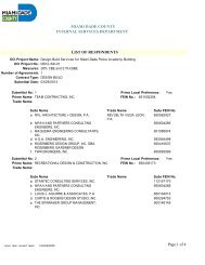
Ojus Urban Area (OUA) District - Miami-Dade Portal
Ojus Urban Area (OUA) District - Miami-Dade Portal
Ojus Urban Area (OUA) District - Miami-Dade Portal

Create successful ePaper yourself
Turn your PDF publications into a flip-book with our unique Google optimized e-Paper software.
Article XXXIII(O), Chapter 33, Code of <strong>Miami</strong>-<strong>Dade</strong> County, Florida<br />
<strong>Ojus</strong> <strong>Urban</strong> <strong>Area</strong> (<strong>OUA</strong>) <strong>District</strong><br />
The <strong>Ojus</strong> <strong>Urban</strong> <strong>Area</strong> <strong>District</strong> was adopted into the zoning code in 2006 by Ordinance 06-86.<br />
This district was subsequently amended in 2007 by ordinance 07-94. This document is formatted<br />
for clarity in text and graphics. For the official adopted article, refer to the Code of <strong>Miami</strong>-<strong>Dade</strong><br />
County published by the Municipal Code Corp., available online at<br />
www.municode.com.<br />
Sec. 33-284.99.14 Purpose, intent and applicability.<br />
A. The regulations contained in this chapter<br />
and Chapter 18A, Landscape Code, Code<br />
of <strong>Miami</strong>-<strong>Dade</strong> County, Florida, shall apply<br />
to this article, except as otherwise added to<br />
or modified herein.<br />
B. The Illustrative Master Plan (Figure 1), illustrates<br />
the citizens’ vision and may be used<br />
to interpret this article. Where the Illustrative<br />
Master Plan conflicts with the text of this article,<br />
the text shall govern.<br />
C. The regulations contained in this chapter<br />
address portions of the <strong>Ojus</strong>/Aventura Metropolitan<br />
<strong>Urban</strong> Center and its surrounding<br />
area. Specifically it addresses an area with<br />
the boundaries shown in the Boundary<br />
Plan, hereafter the <strong>Ojus</strong> <strong>Urban</strong> <strong>Area</strong> <strong>District</strong><br />
(<strong>OUA</strong>D) and generally described as follows:<br />
from the crossing of the Oleta River with the<br />
west side of the Florida East Cost (FEC) railroad<br />
easement, then north along the west<br />
side of the FEC railroad easement to the<br />
south side of NE 203 Street, then west<br />
along the south side of NE 203 Street to the<br />
west side of NE 26 Avenue, then north<br />
along the west side of NE 26 Avenue to the<br />
south side of theoretical NE 206 Street then<br />
west along the south side of theoretical NE<br />
206 Street to the eastern boundary of the<br />
Highland Oaks Park, then north and west<br />
along the boundary of Highland Oaks Park<br />
to the east side of NE 23 Avenue, then<br />
south on the east side of NE 23 Avenue to<br />
the north side of NE 207 Street, then east<br />
along the north side of NE 207 Street to the<br />
east side of NE 24 Avenue, then south<br />
along the east side of NE 24 Avenue to the<br />
south side on NE 203 Street, then east<br />
along the south side of NE 203 Street to the<br />
Oleta River, then south along the Oleta River<br />
to the point of beginning.<br />
A more detailed legal description of the<br />
boundaries follows:<br />
Beginning at the intersection of the East<br />
Right-of-Way line of the Oleta River with the<br />
West Right-of-Way line of the Florida East<br />
Coast railroad, thence North along the<br />
aforementioned West Right-of-Way line of<br />
the Florida East Coast railroad to the intersection<br />
with the centerline of NE 203 Street,<br />
thence West along the aforementioned cen-
2 <strong>District</strong> Regulations<br />
terline of NE 203 Street to the intersection<br />
with the centerline of NE 26 Avenue, thence<br />
North along the aforementioned centerline<br />
of NE 26 Avenue to the intersection with the<br />
theoretical extension of the North Property<br />
line of Tract “A” of BETH TORAH ADATH<br />
YESHURUN as recorded in Plat Book 147,<br />
Page 50 of the <strong>Miami</strong>-<strong>Dade</strong> County Public<br />
Records, thence West along the aforementioned<br />
North Property line of Tract “A” to the<br />
intersection with the East Right-of-Way line<br />
of the Oleta River, thence North along the<br />
aforementioned East Right-of-Way line of<br />
the Oleta River to the intersection with the<br />
East Property line of Highland Oaks Park,<br />
thence North along the aforementioned East<br />
Property line of Highland Oaks Park to the<br />
intersection with the North Property line of<br />
Highland Oaks Park, thence West along the<br />
aforementioned North Property line of Highland<br />
Oaks Park to the theoretical intersection<br />
with the centerline of NE 23 Avenue,<br />
thence South along the aforementioned<br />
centerline of NE 23 Avenue to the intersection<br />
with the Northern boundary of Highland<br />
Oaks Elementary School, thence East along<br />
the aforementioned Northern boundary of<br />
Highland Oaks Elementary School for a distance<br />
of 546 feet (+/-) to a point, thence<br />
Southeast along the Northeast boundary of<br />
Highland Oaks Elementary School for a distance<br />
of 125 feet (+/-) to a point, thence<br />
East to the intersection with the centerline of<br />
NE 24 Avenue, thence South along the<br />
aforementioned centerline of NE 24 Avenue<br />
to the intersection with the centerline of NE<br />
203 Street, thence East along the aforementioned<br />
centerline of NE 203 Street to the<br />
intersection with the East Right-of-Way line<br />
of the Oleta River, thence South along the<br />
aforementioned East Right-of-Way line of<br />
the Oleta River to the Point of Beginning.<br />
D. Full scale maps of the Illustrative Master<br />
Plan presented in Figure 1, as well as all the<br />
Regulating Plans and Street Development<br />
Parameters figures in this article, are on file<br />
with the <strong>Miami</strong>-<strong>Dade</strong> Department of Planning<br />
and Zoning.<br />
E. No provision in this article shall be applicable<br />
to any property lying outside the<br />
boundaries of the <strong>OUA</strong>D as described<br />
herein. No property lying within the boundaries<br />
of the <strong>OUA</strong>D shall be entitled to the<br />
uses or subject to the regulations provided<br />
in this article until an application for a district<br />
boundary change to <strong>OUA</strong>D has been heard<br />
and approved in accordance with the provisions<br />
of this chapter.
<strong>Ojus</strong> <strong>Urban</strong> <strong>Area</strong> 3<br />
Figure 1: Illustrative Master Plan
4 <strong>District</strong> Regulations<br />
Sec. 33-284.99.15 <strong>Ojus</strong> <strong>Urban</strong> <strong>Area</strong> <strong>District</strong> (<strong>OUA</strong>D) Requirements.<br />
Except as provided herein, all developments within the <strong>OUA</strong>D shall comply with the requirements provided<br />
in Article XXXIII(K), Standard <strong>Urban</strong> Center <strong>District</strong> Regulations, of this code.<br />
Sec. 33-284.99.17 Uses.<br />
Except as provided herein, all permitted, conditionally permitted, and temporary uses within the <strong>OUA</strong>D<br />
shall comply with Section 33-284.83 of this Code.<br />
1. As provided in the Land Use Regulating Plan, no duplexes shall be permitted in areas designated:<br />
a. Residential (R) with a maximum permitted density of 6 dwelling units per net acre; and<br />
b. Residential Modified (RM) with maximum permitted densities greater or equal to 36 units<br />
per net acre.<br />
2. No municipal recreation building, playground, or park owned and operated by a municipality,<br />
county, state, or the federal government shall be permitted in areas designated R on the Land<br />
Use Regulating Plan.<br />
3. No civic uses shall be permitted in areas designated R on the Land Use Regulating Plan, except<br />
for educational facilities on properties not to exceed 5 acres.<br />
4. Industrial uses. Notwithstanding the provisions of Section 33-284.83 (A)(4), only the following<br />
uses shall be permitted in the Industrial <strong>District</strong> (ID) area. These uses shall be allowed in conformance<br />
with the Land Use Regulating Plan and the Street Type Development Parameters.<br />
a. All uses permitted in the IU-1 zoning district<br />
b. All uses permitted in the IU-2 zoning district after public hearing pursuant to section 33-<br />
311(A)(3) of this code.<br />
c. MC uses at a maximum density of 52 units net acre or at a maximum density of 60 units<br />
per net acre with the purchase of the appropriate number of Severable Use Rights pursuant<br />
to Sections 33B-41 to 33B-47 of this code.<br />
d. live-work units as provided in Sec. 33-284.83(A)(4)(b).<br />
e. On lots fronting West Dixie Highway and south of NE 195 Street, all uses permitted in the<br />
Mixed Use Main Street (MM), at a minimum density of 12 units per net acre and at a<br />
maximum density of 52 units net acre, or a maximum density of 60 units per net acre
<strong>Ojus</strong> <strong>Urban</strong> <strong>Area</strong> 5<br />
with the purchase of the appropriate number of Severable Use Rights as permitted by<br />
Section 33B-41 to Section 33B-47 of this code<br />
f. On lots fronting NE 26th Avenue, all uses permitted in the Residential Modified (RM), at a<br />
minimum density of 12 units per net acre and a maximum density of 36 units net acre.<br />
5. Institutional uses. The following additional uses shall be permitted in the Institutional (I) area in<br />
accordance with the Land Use Regulating Plan and the Street Types Development Parameters.<br />
a. Civic uses in accordance with the Street Types Development Parameters.<br />
b. On lots located west of NE 25th Avenue, all uses permitted in the Residential (R), with a<br />
minimum density of 6 units per net acre and a maximum density of 13 units per net acre.<br />
c. On lots located east of NE 25th Avenue, all uses permitted in the Residential Modified<br />
(RM), with a minimum density of 12 units per net acre and a maximum density of 36<br />
units per net acre.<br />
6. Conditionally Permitted Uses. Notwithstanding the provisions of Section 33-284.83 (B), only the<br />
following conditional uses shall be permitted subject to the administrative approval of a site plan,<br />
pursuant to Section 33-284.88 of this code.<br />
1. Liquor package stores shall be permitted only in the Core Sub-district and only in compliance<br />
with all applicable regulations of this code.<br />
Sec. 33-284.99.18 The Regulating Plans.<br />
The Regulating Plans shall consist of the following controlling plans, as defined and graphically depicted<br />
in this section.<br />
A. The Street Types Plan, which establishes a hierarchy of street types in existing and future locations.<br />
The five Street Types and the hierarchy of streets (from most important to least important in<br />
accommodating all types of activity) are U.S. 1, Main Street, Boulevard, Minor Street, and Service<br />
Road.<br />
B. The Sub-districts Plan, which delineates 3 Sub-districts: Core, Center and Edge. These Subdistricts<br />
shall regulate the allowable intensity of development in accordance with the Comprehensive<br />
Development Master Plan and this article.<br />
C. The Land Use Plan, which delineates the areas where specified land uses and development of<br />
various types and intensities shall be permitted.
6 <strong>District</strong> Regulations<br />
D. The Building Heights Plan, which establishes the minimum and maximum allowable number of<br />
stories.<br />
E. The Designated Open Space Plan, which designates open spaces. The designated open spaces<br />
shall be controlled by anchor points.<br />
F. The New Streets Plan, which shows the location and the number of new streets needed to create<br />
the prescribed network of streets within the <strong>Ojus</strong> <strong>Urban</strong> <strong>Area</strong>. All new A streets shall be required in<br />
the same general location as shown on the New Streets Plan. All B streets shall be located as provided<br />
in Section 33-284.86(F) of this code.<br />
G. The Bike Route Plan, which depicts the designated bike routes, including the bike facility requirements<br />
if any, which shall be shown in all development plans.
<strong>Ojus</strong> <strong>Urban</strong> <strong>Area</strong> 7<br />
I. Street Types Plan
8 <strong>District</strong> Regulations<br />
II. Sub-<strong>District</strong> Plan
<strong>Ojus</strong> <strong>Urban</strong> <strong>Area</strong> 9<br />
III. Land Use Plan
10 <strong>District</strong> Regulations<br />
V. Building Heights Plan
<strong>Ojus</strong> <strong>Urban</strong> <strong>Area</strong> 11<br />
VI. Designated Open Space Plan
12 <strong>District</strong> Regulations<br />
VII. New Street Dedications Plan
<strong>Ojus</strong> <strong>Urban</strong> <strong>Area</strong> 13<br />
VIII. Bike Route Plan
14 <strong>District</strong> Regulations<br />
Sec. 33-284.99.19 Building Placement and Street Type Development Parameters<br />
A. All new development and redevelopment within the <strong>OUA</strong>D shall comply with the Building Placement and<br />
Design Parameters as provided in Section 33-284.85 of this code.<br />
B. All new development and redevelopment within the <strong>OUA</strong>D shall comply with the Street Type Parameters<br />
as provided herein:<br />
Street type Minimum Required Configuration<br />
Main Street As provided herein<br />
Boulevard (NE 26 th Avenue) As provided herein<br />
Boulevard As provided in section 33-284.85<br />
Minor Street As provided herein or in section 33-284.85<br />
Service Road As provided in section 33-284.85<br />
Pedestrian Passage As provided in section 33-284.85<br />
C. Unless otherwise provided by the Building Placement and Design Parameters in section 33-284.85 of<br />
this code, the following street setbacks shall be required for mixed-use/industrial buildings located in areas<br />
designated as MM, MC and ID within the <strong>OUA</strong>D:<br />
Street Type Required Setback<br />
Core Center Edge<br />
Main Street 0’ * or 12’ N/A N/A<br />
Boulevard (NE 26 Avenue) N/A 0’ or 10’ 10’ or 15’<br />
Boulevard (Other) 0’ 0’ or 10’ 10’ or 15’<br />
Minor Street 0’ or 10’ 0’ or 10’ 10’ 0r 15’<br />
Note: * 12’ colonnade required when setback is 0’<br />
** as provided in Section 33-284.99.19 of this code<br />
N/A not applicable
<strong>Ojus</strong> <strong>Urban</strong> <strong>Area</strong> 15
16 <strong>District</strong> Regulations
<strong>Ojus</strong> <strong>Urban</strong> <strong>Area</strong> 17
18 <strong>District</strong> Regulations<br />
Sec. 33-284.99.20 General Requirements.<br />
In addition to the requirements in Section 33-284.86 of this code, and to retain the character of the development<br />
within the <strong>OUA</strong>D, all new development and redevelopment shall comply with the following:<br />
A. Heights of Buildings.<br />
1. Except where exempted as depicted on the Building Heights Plan, where a proposed development abuts<br />
an area designated Residential (R) on the Land Use Regulating Plan, the height of the proposed development<br />
along the abutting property line, for a minimum depth of 50 feet, shall be no greater than the<br />
maximum height allowed in the abutting area designated R. Examples of the required height transition<br />
are shown herein.<br />
Example of building heights transition from mixed-use to single-family<br />
Each story shall have a maximum height of 16 feet, as measured from floor to floor. Any height above<br />
16 feet shall count as an additional story, except that a single story may have a maximum height of 30<br />
feet, provided that no mezzanine area intended for commercial use exceeds 10 percent and no mezzanine<br />
area intended for residential use exceeds 80 percent of the floor area of that story.<br />
B. Architectural Guidelines.<br />
To retain the character of the development in the <strong>OUA</strong>D area and to recognize its architectural history, all new<br />
single-family development within the <strong>OUA</strong>D area shall conform with either the Florida Vernacular or the Mission<br />
style as shown in the figures below. Specifically and at a minimum, all new single-family homes within the area<br />
shall include each of the required elements, respective to the chosen architectural style, described herein:
<strong>Ojus</strong> <strong>Urban</strong> <strong>Area</strong> 19<br />
Architectural<br />
Style<br />
Required elements<br />
Florida Ver- 1. Side gabled roof with shingles and a slope of 6:12 or 12:12<br />
nacular<br />
2. Operable, boarded shutters sized to the window opening<br />
3. Attached front porch<br />
Mission 1. Shaped Mission dormer or roof parapet<br />
2. Arched openings<br />
3. Overhanging eaves with exposed rafters.<br />
Additional defining elements are shown in the figures provided herein, and shall be optional.
20 <strong>District</strong> Regulations
<strong>Ojus</strong> <strong>Urban</strong> <strong>Area</strong> 21
22 <strong>District</strong> Regulations
<strong>Ojus</strong> <strong>Urban</strong> <strong>Area</strong> 23
24 <strong>District</strong> Regulations
<strong>Ojus</strong> <strong>Urban</strong> <strong>Area</strong> 25<br />
Sec. 33-284.99.21 Conflicts with other Chapters and Regulations.<br />
This article shall govern in the event of conflicts with other zoning, subdivision, or landscape regulations of this<br />
code, or with the <strong>Miami</strong>-<strong>Dade</strong> Department of Public Works Manual of Public Works.<br />
Sec. 33-284.99.22 Non-conforming Structures, Uses, and Occupancies.<br />
Nothing contained in this article shall be deemed or construed to prohibit a continuation of a legal nonconforming<br />
structure, use, or occupancy in the <strong>OUA</strong>D that either (1) was existing as of the date of the district boundary<br />
change on the property to <strong>OUA</strong>D or (2) on or before said date, had received final site plan approval through a<br />
public hearing pursuant to this chapter or through administrative site plan review or had a valid building permit.<br />
However, any structure, use, or occupancy in the <strong>OUA</strong>D that is discontinued for a period of at least six months,<br />
or is superseded by a lawful structure, use or occupancy permitted under this chapter, or that incurs damage to<br />
the roof or structure to an extent of 50 percent or more of its market value, shall be subject to Section 33-35(c) of<br />
this code. However, a lawfully existing single-family home use that is discontinued for a period of at least six<br />
months or that incurs damage to the roof or structure to an extent of 50 percent or more of its market value, shall<br />
not be subject to Section 33-35(c) of this code..