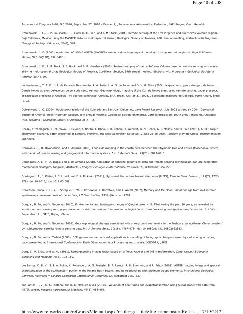
Astronautical Congress 2010, IAC 2010, September 27, 2010 - October 1, , International Astronautical Federation, IAF, Prague, Czech Republic. Dmochowski, J. E., B. P. Hausback, S. J. Hook, D. C. Pieri, and J. M. Stock (2001), Remote sensing of the Tres Virgenes and Puertecitos volcanic regions, Baja California, Mexico, using the MASTER airborne multi-spectral sensor; Geological Society of America, 2001 annual meeting, Abstracts with Programs - Geological Society of America, 33(6), 348. Dmochowski, J. E. (2005), Application of MODIS-ASTER (MASTER) simulator data to geological mapping of young volcanic regions in Baja California, Mexico, DAI, 66(12B), 242-6496. Dmochowski, J. E., J. M. Stock, S. J. Hook, and B. P. Hausback (2003), Revised mapping of the La Reforma Caldera based on remote sensing with master airborne multi-spectral data; Geological Society of America, Cordilleran Section, 99th annual meeting, Abstracts with Programs - Geological Society of America, 35(4), 29. do Nascimento, T. A. F., P. S. de Rezende Nascimento, R. A. Petta, L. A. N. de Paiva, and D. V. G. Silva (2008), Mapeamento geomorfologico da folha Currais Novos atraves de tecnicas de sensoriamento remoto. Geomorphologic mapping of the Currais Novos sheet using remote sensing, paper presented at Sociedade Brasileira de Geologia; 44 degrees congresso, Curitiba, BRA, Brazil, Oct. 26-31, 2008, , Sociedade Brasileira de Geologia, Porto Alegre, Brazil (BRA). Dohrenwend, J. C. (2004), Rapid progradation of the Colorado and San Juan Deltas into Lake Powell Reservoir, July 2002 to January 2004; Geological Society of America, Rocky Mountain Section, 56th annual meeting; Geological Society of America, Cordilleran Section, 100th annual meeting, Abstracts with Programs - Geological Society of America, 36(4), 15. Doi, N., Y. Yamaguchi, H. Muraoka, H. Sekine, T. Narita, T. Ohno, R. H. Cohen, D. Wenkert, G. N. Geller, A. R. Molloy, and M. Pniel (2001), ASTER target observation scenario, paper presented at Sensors, Systems, and Next-Generation Satellites IV, Sep 25-28 2000, , Society of Photo-Optical Instrumentation Engineers. Domakinis, C., D. Oikonomidis, and T. Astaras (2008), Landslide mapping in the coastal area between the Strymonic Gulf and Kavala (Macedonia, Greece) with the aid of remote sensing and geographical information systems, Int. J. Remote Sens., 29(23), 6893-6915. Domingues, A. L., M. A. Braga, and T. de Almeida (2008), Application of airborne geophysical data and remote sensing techniques in iron ore exploration, International Geological Congress, Abstracts = Congres Geologique International, Resumes, 33, @Abstract 1257156. Dominguez, A., J. Kleissl, J. C. Luvall, and D. L. Rickman (2011), High-resolution urban thermal sharpener (HUTS), Remote Sens. Environ., 115(7), 1772- 1780, doi:10.1016/j.rse.2011.03.008. Donaldson Hanna, K. L., A. L. Sprague, R. W. H. Kozlowski, K. Boccafolo, and J. Warell (2007), Mercury and the Moon; initial findings from mid-infrared spectroscopic measurements of the surface; LPI Contribution, 1338, @Abstract 2291. Dong, Y., B. Fu, and Y. Ninomiya (2010), Environmental and landscape changes of Qinghai Lake, N. E. Tibet during the past 30 years, as revealed by satellite remote sensing data, paper presented at 6th International Symposium on Digital Earth: Data Processing and Applications, September 9, 2009 - September 12, , SPIE, Beijing, China. Dong, Y., B. Fu, and Y. Ninomiya (2009), Geomorphological changes associated with underground coal mining in the Fushun area, northeast China revealed by multitemporal satellite remote sensing data, Int. J. Remote Sens., 30(18), 4767-4784, doi:10.1080/01431160802662923. Dong, Y., B. Fu, and N. Yoshiki (2008), DEM generation methods and applications in revealing of topographic changes caused by coal mining activities, paper presented at International Conference on Earth Observation Data Processing and Analysis, ICEODPA, , SPIE. Dong, Z., P. Zhao, and W. Hu (2011), Remote sensing images fusion based on a'Trous wavelet and IHS transformation, Cehui Kexue / Science of Surveying and Mapping, 36(2), 178-180. dos Santos, D. R. V., S. B. A. Rolim, A. Roisenberg, A. G. Preissler, E. F. Ramos, R. R. Salomoni, and R. Frizzo (2008), ASTER mapping image and spectral characterization of the southwestern portion of the Parana Basin basalts, and its relationships with platinum groups elements, International Geological Congress, Abstracts = Congres Geologique International, Resumes, 33, @Abstract 1257153. dos Santos, T. V., D. C. Fontana, and R. C. Marques Alves (2010), Evaluation of heat fluxes and evapotranspiration using SEBAL model with data from ASTER sensor, Pesquisa Agropecuaria Brasileira, 45(5), 488-496. http://www.refworks.com/refworks2/default.aspx?r=file::get_file&file_name=aster-RefLis... Page 40 of 208 7/19/2012
Dousset, B. (2002), First results of the EOS - Terra ASTER observations over Marseille during the UBL/CLU-ESCOMPTE experiment (2002 - 4Urban); Proceedings of the Fourth AMS Symposium on the Urban Environment. Dowdeswell, J. A., T. J. Benham (2003), A surge of Perseibreen, Svalbard, examined using aerial photography and ASTER high resolution satellite imagery, Polar Res., 22(2), 373-83. Dowdeswell, J. A. (2003), Form and flow of Arctic ice caps; remote-sensing investigations from aircraft and satellites, paper presented at IUGG 2003, Sapporo, JPN, Japan, June 30-July 11, 2003, , IUGG, [location varies],. Dowman, I., P. Balan (2007), Mapping remote areas using SRTM and ASTER digital elevation model data; a solution to orientation problems, in Mapping hazardous terrain using remote sensing, , vol. 283, edited by R. M. Teeuw, pp. 143-147, London, United Kingdom (GBR), Geological Society of London. Dozier, J., Z. Wan (1994), Development of practical multiband algorithms for estimating land-surface temperature from EOS/MODIS data, Advances in Space Research, 14(3), 10; p. (3)81-(3)90. Drackett, T. M., Y. Zaiki (1993), Thermal control subsystem design for the EOS Thermal Infrared Radiometer, paper presented at SAE, International Conference on Environmental Systems, 23rd, Colorado Springs, CO; UNITED STATES; 12-15 July 1993, . Drechsel, C. A., R. D. Jacobi, J. R. Everett, and R. J. Staskowski (2004), ASTER lineaments, faults, and reservoirs in the Appalachian Basin of New York State; Geological Society of America, Northeastern Section, 38th annual meeting; Geological Society of America, Southeastern Section, 53rd annual meeting, Abstracts with Programs - Geological Society of America, 36(2), 146. Drenth, B. J. (2011), Identification of gravity, magnetic, and radiometric geophysical anomalies in Afghanistan, U.S. Geological Survey Open File Report, 2011-1229, 10-35, doi:http://pubs.usgs.gov/of/2011/1229/. Drury, S. A. (2004), Early structural features on the flanks of the Afar-Danakil basin revealed by ASTER image data, International Geological Congress, Abstracts = Congres Geologique International, Resumes, 32, Part 1, 628. D'Sa, E., C. Hall, V. Zanoni, D. Holland, S. Blonski, M. Pagnutti, and J. P. Spruce (2004), Decision Support Tool Evaluation Report for Coral Reef Early Warning System (CREWS) Version 7.0, SSTI-2220-0051, 1-65. Du Wei-jing, Li Shu-min, Li Hong, Sun Dan-feng, and Zhou Lian-di (2010), Spectral Characteristics Analysis and Remote Sensing Inversion of Water Quality Parameters in Han Shiqiao Wetland, Spectroscopy and Spectral Analysis/Guang Pu Xue Yu Guang Pu Fen Xi, 30(3), 757-761, doi:10.3964/j.issn.1000-0593 (2010)03-0757-05. Du, M., G. Cai, and D. Qiu (2009), Relationship between urban heat sink and heat energy exchange in Beijing, China, paper presented at Geoscience and Remote Sensing Symposium,2009 IEEE International,IGARSS 2009, , IEEE, Cape Town, South Africa. Du, M., W. Sun, and G. Cai (2008), Calculation of corridor structure effect on urban heat island using highly spatial resolution satellite images in Beijing, China, paper presented at IGARSS 2008 - 2008 IEEE International Geoscience and Remote Sensing Symposium, , IEEE. Du, P., P. Liu, H. Zhang, and H. Zhang (2008), Multi-objective processing of ASTER image for urban environmental analysis, paper presented at 2007 IEEE International Geoscience and Remote Sensing Symposium, IGARSS 2007, , Institute of Electrical and Electronics Engineers Inc., Piscataway, NJ 08855- 1331, United States, Barcelona, Spain. Du1, P., H. Zhang1, P. Liu1, K. Tan1, and Z. Yin1 (2007), Land use/cover change in mining areas using multi-source remotely sensed imagery, paper presented at Proceedings of MultiTemp 2007 - 2007 International Workshop on the Analysis of Multi-Temporal Remote Sensing Images, , IEEE. Ducart, D. F., A. P. Crosta, C. R. S. Filho, and J. Coniglio (2006), Alteration mineralogy at the Cerro La Mina epithermal prospect, Patagonia, Argentina: Field mapping, short-wave infrared spectroscopy, and ASTER images, Economic Geology, 101, 981-996. Duda, K. A., M. Abrams (2005), ASTER and USGS EROS Disaster Response: Emergency imaging after Hurricane Katrina, Photogramm. Eng. Remote Sensing, 71(12), 1346-1350. Duda, K. A., M. Abrams (2007), ASTER and USGS EROS emergency imaging for hurricane disasters, U.S.Geological Survey Circular, C 1306, 80-86. Duda, K. A., R. Wessels, M. Ramsey, and J. Dehn (2008), Monitoring volcanic threats using ASTER satellite data, paper presented at 2007 IEEE http://www.refworks.com/refworks2/default.aspx?r=file::get_file&file_name=aster-RefLis... Page 41 of 208 7/19/2012
- Page 1 and 2: REFERENCES Future European and Japa
- Page 3 and 4: Emerging and Future Technologies fo
- Page 5 and 6: Abrams, M., S. J. Hook (1995), Simu
- Page 7 and 8: Alfarhan, M. S., S. M. Arafat, and
- Page 9 and 10: Aosier, B., K. Tsuchiya, and M. Kan
- Page 11 and 12: data; a new methodological approach
- Page 13 and 14: Azizzadeh, M., S. Shahriari, and F.
- Page 15 and 16: Barcaza, G., M. Aniya, T. Matsumoto
- Page 17 and 18: Benn, D., J. Gulley, and S. S. Thom
- Page 19 and 20: Victoria; Dynamic Earth; past, pres
- Page 21 and 22: Bonnici, M., P. Eisner (2007), Geom
- Page 23 and 24: Brown, A. J., S. J. Hook, J. K. Cro
- Page 25 and 26: California; Lunar and planetary sci
- Page 27 and 28: Italiana, Rome, Italy (ITA). Carter
- Page 29 and 30: Inc, Vancouver, BC, Canada. Chao, Z
- Page 31 and 32: Cheng, T., D. Riano, A. Koltunov, M
- Page 33 and 34: 86(52, Suppl.), @Abstract T23B-0555
- Page 35 and 36: Csiszar, I. A., J. T. Morisette, an
- Page 37 and 38: Davis, A. (2007), The Use of Commer
- Page 39: 183. Dey, S., L. di Girolamo, and G
- Page 43 and 44: their resources and mitigation of t
- Page 45 and 46: Falkowski, M. J., P. E. Gessler, P.
- Page 47 and 48: Zigui, Landslides, 4(3), 267-278, d
- Page 49 and 50: Fu, B., Y. Ninomiya, X. Lei, S. Tod
- Page 51 and 52: Gad, S., M. El-Shafei, and T. Kusky
- Page 53 and 54: Genkova, I., G. Seiz, P. Zuidema, G
- Page 55 and 56: Giri, C., J. Long, and L. Tieszen (
- Page 57 and 58: Gowda, P. H., J. L. Chavez, P. D. C
- Page 59 and 60: ground measurements and aster image
- Page 61 and 62: Pamir, Afghanistan, Clim. Change, 9
- Page 63 and 64: He, D., Y. Meng, and C. Wang (2011)
- Page 65 and 66: Hewson, R., T. Cudahy (2008), Hyper
- Page 67 and 68: Hydrothermal Alteration in the Jeba
- Page 69 and 70: J. Remote Sens., 32(20), 5645-5663.
- Page 71 and 72: Hugenholtz, C. H., T. E. Barchyn (2
- Page 73 and 74: Inbar, M., M. Gilichinsky, I. Melek
- Page 75 and 76: Jacob, F., F. Petitcolin, T. Schmug
- Page 77 and 78: Jochum, A. M., A. Calera, and A. Cu
- Page 79 and 80: 527-554. Kaeaeb, A., Zurich GLIMS T
- Page 81 and 82: Kamp, U., T. Bolch, J. Olsenholler,
- Page 83 and 84: University of Technology, NO.36,dai
- Page 85 and 86: from palaeomagnetism and (super 40)
- Page 87 and 88: Khromova, T. E., G. B. Osipova, D.
- Page 89 and 90: KOBAYASHI, Y., Y. Yasuoka (2007), E
- Page 91 and 92:
Kropaacek, J., V. Hochschild (2009)
- Page 93 and 94:
Hekimhan (Malatya) ornegi--Mapping
- Page 95 and 96:
Lasaponara, R., A. Lanorte (2007),
- Page 97 and 98:
Li, H., W. Li, and X. Li (2006), Ap
- Page 99 and 100:
language=English&verbose=0&listenv=
- Page 101 and 102:
Liu, Y., M. Li, J. Yang, and Y. Shu
- Page 103 and 104:
(GLIMS) and the GLIMS Information M
- Page 105 and 106:
Int. J. Remote Sens., 26(7), 1347-1
- Page 107 and 108:
Matano Yoneji, I. K. , G. Saito, an
- Page 109 and 110:
Matthews, J. (2005), Stereo observa
- Page 111 and 112:
Messinger, D. W., D. McKeown, N. Ra
- Page 113 and 114:
Mitsuishi, M., S. R. Wallis, M. Aoy
- Page 115 and 116:
Morisette, J. T., L. Giglio, I. Csi
- Page 117 and 118:
0010, United States. Mushkin, A., A
- Page 119 and 120:
exploration of the Marifil Formatio
- Page 121 and 122:
Nikolakopoulos, K. G., G. Lathourak
- Page 123 and 124:
Proceedings of the Institute of Nat
- Page 125 and 126:
Ogawa, K., T. Schmugge, F. Jacob, a
- Page 127 and 128:
Ono, A., F. Sakuma (1991), ASTER ca
- Page 129 and 130:
the Conference, Denver, CO; 3-6 Aug
- Page 131 and 132:
Peet, V. M., M. S. Ramsey, and D. A
- Page 133 and 134:
Phillips, R., O. Beeri, E. Schollje
- Page 135 and 136:
topographic maps with interferogram
- Page 137 and 138:
Rager, A. H., H. B. Rager, and G. R
- Page 139 and 140:
Geological Society of America Bulle
- Page 141 and 142:
Realmuto, V. J., A. J. Sutton, and
- Page 143 and 144:
99, 7-21. Rivero, R. G., S. Grunwal
- Page 145 and 146:
Rokugawa, S., H. Tsu, and A. B. Kah
- Page 147 and 148:
imagery, Geomorphology, 100(3-4), 4
- Page 149 and 150:
Sakuno, Y., T. Matsunaga, T. Kozu,
- Page 151 and 152:
fracture; satellite observations an
- Page 153 and 154:
(ASTER), paper presented at Image a
- Page 155 and 156:
Schroeder, W., I. Csiszar, L. Gigli
- Page 157 and 158:
environment, Catena, 87(1), 11-19,
- Page 159 and 160:
Shroder, J. F., Jr, M. P. Bishop (2
- Page 161 and 162:
Sluiter, R., E. J. Pebesma (2010),
- Page 163 and 164:
Soti, V., C. Puech, D. Lo Seen, A.
- Page 165 and 166:
Steffke, A. M., R. L. Nusbaum, and
- Page 167 and 168:
Sultana, D. N., M. G. Abdelsalam (2
- Page 169 and 170:
Tachikawa, T., M. Hato, M. Kaku, an
- Page 171 and 172:
Takeuchi Wataru, Y. Y. (2004), Deve
- Page 173 and 174:
Taschner, S., R. Ranzi (2002), Comp
- Page 175 and 176:
Sens., 46(10), 3285-3295. Thome, K.
- Page 177 and 178:
Tonooka, H., M. Hirayama (2010), Wa
- Page 179 and 180:
Tovinkere, V. R., M. Penaloza, A. L
- Page 181 and 182:
Ukawa, K., K. Kato (2006), Relation
- Page 183 and 184:
Urai, M., H. Muraoka, A. Nasution,
- Page 185 and 186:
simulator data, Remote Sensing of E
- Page 187 and 188:
Wang, G. -., Z. -. He, W. -. Qiu, a
- Page 189 and 190:
Warner, N. H., J. D. Farmer (2008),
- Page 191 and 192:
Wei-tao, C., Z. Zhi, L. Zhi-zhong,
- Page 193 and 194:
Geological Survey of Canada, 5643,
- Page 195 and 196:
Wynn, J. C., J. L. Mars, F. Gray, A
- Page 197 and 198:
Yamaguchi, H., Takahashi Fumiho, an
- Page 199 and 200:
YAN, W. (2006), Extraction of Therm
- Page 201 and 202:
Yin, G., J. Shen, J. Jiang, and G.
- Page 203 and 204:
Perspective, IEEE Trans. Geosci. Re
- Page 205 and 206:
Cu-Au deposit as an example, Dixue
- Page 207 and 208:
Zoran, L. F. V., C. Golovanov, and


