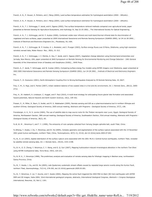
French, A. N., P. Houser, A. Pinheiro, and J. Meng (2004), Land surface temperature estimation for hydrological assimilation (2004 - 18Hydro). French, A. N., P. Houser, A. Pinheiro, and J. Meng (2004), Land surface temperature estimation for hydrological assimilation (2004 - 18Hydro). French, A. N., T. J. Schmugge, F. Jacob, and K. Ogawa (2002), Two surface temperature retrieval methods compared over agricultural lands, paper presented at Remote Sensing for Agriculture Ecosystems, and Hydrology IV, Sep 22-25 2002, , The International Society for Optical Engineering. French, A. N., T. J. Schmugge, and W. P. Kustas (2000), Combined visible-near infrared and multi-band thermal infrared data for discrimination of vegetated and bare surfaces, paper presented at 2000 Internaitonal Geoscience and Remote Sensing Symposium (IGARSS 2000), Jul 24-Jul 28 2000, , Institute of Electrical and Electronics Engineers Inc., Piscataway, NJ, USA. French, A. N., T. J. Schmugge, W. P. Kustas, K. L. Brubaker, and J. Prueger (2003), Surface energy fluxes over El Reno, Oklahoma, using high-resolution remotely sensed data, Water Resour. Res., 39(6), 31-312. French, A. N., T. J. Schmugge, J. C. Ritchie, A. Hsu, F. Jacob, and K. Ogawa (2007), Vegetation change detection using thermal band emissivities over Jornada, New Mexico, USA, paper presented at IAHS Symposium on Remote Sensing for Environmental Monitoring and Change Detection - 24th General Assembly of the International Union of Geodesy and Geophysics (IUGG), , IAHS Press. French, A., F. Jacob, T. Schmugge, and W. Kustas (2002), Comparing surface energy flux models using ASTER imagery over Oklahoma, paper presented at 2002 IEEE International Geoscience and Remote Sensing Symposium (IGARSS 2002), Jun 24-28 2002, , Institute of Electrical and Electronics Engineers Inc. Freund, F., D. Ouzounov (2001), Earth-Atmospheric Coupling Prior to Strong Earthquakes Analyzed by IR Remote Sensing Data, 32, 0627. Frey, C. M., G. Rigo, and E. Parlow (2007), Urban radiation balance of two coastal cities in a hot and dry environment, Int. J. Remote Sens., 28(12), 2695- 2712. Frey, H., W. Haeberli, A. Linsbauer, C. Huggel, and F. Paul (2010), A multi-level strategy for anticipating future glacier lake formation and associated hazard potentials, Natural Hazards and Earth System Sciences, 10(2), 339-352. Friesen, E., N. Miller, R. Stern, S. Arafat, and M. G. Abdelsalam (2005), Remote sensing and GIS as a cyberreconnaisance tool in northern Ethiopia and southern Eritrea; Geological Society of America, 2005 annual meeting, Abstracts with Programs - Geological Society of America, 37(7), 108. Fronabarger, A. K., N. S. Levine (2004), The use of satellite data to map source rocks for the Theban necropolis near Luxor, Egypt; Geological Society of America, Northeastern Section, 38th annual meeting; Geological Society of America, Southeastern Section, 53rd annual meeting, Abstracts with Programs - Geological Society of America, 36(2), 65. Fu B, W. M. , Ninomiya Y, and T. Y. (1999), The emissivity of rock samples collected from Yarlung Zangbo ophiolite belt, south Tibet, China. Fu Bihong, Y. Awata, J. Du, Y. Ninomiya, and W. He (2005), Complex geometry and segmentation of the surface rupture associated with the 14 November 2001 great Kunlun earthquake, northern Tibet, China, Tectonophysics, 407(1-2), 43-63, doi:10.1016/j.tecto.2005.07.002. Fu, B., A. Lin (2003), Spatial distribution of the surface rupture zone associated with the 2001 Ms 8.1 Central Kunlun earthquake, northern Tibet, revealed by satellite remote sensing data, Int. J. Remote Sens., 24(10), 2191-2198. Fu, B. H., G. D. Zheng, Y. Ninomiya, C. Y. Wang, and G. Q. Sun (2007), Mapping hydrocarbon-induced mineralogical alteration in the northern Tian Shan using ASTER multispectral data, Terra Nova, 19(4), 225-231. Fu, B. M. K., Y. Ninomiya (1998), The preliminary analysis and evaluation of remote sensing data for lithologic mapping in Beishan area, northwestern Gansu Province, China. Fu, B., Y. Awata, J. Du, and W. He (2005), Late Quaternary systematic stream offsets caused by repeated large seismic events along the Kunlun Fault, northern Tibet, Geomorphology, 71(3-4), 278-292, doi:10.1016/j.geomorph.2005.03.001. Fu, B., Y. Ninomiya, X. Lei, T. Azuma, and Y. Awata (2004), Mapping the active fault triggered the 2003 MW 6.6 Bam (SE Iran) earthquake with ASTER DEM and 3D images; Italia 2004; 32nd international geological congress; abstracts, International Geological Congress, Abstracts = Congres Geologique International, Resumes, 32, Part 2, 1181. http://www.refworks.com/refworks2/default.aspx?r=file::get_file&file_name=aster-RefLis... Page 48 of 208 7/19/2012
Fu, B., Y. Ninomiya, X. Lei, S. Toda, and Y. Awata (2004), Mapping active fault associated with the 2003 Mw 6.6 Bam (SE Iran) earthquake with ASTER 3D images, Remote Sens. Environ., 92(2), 153-157. Fuchs, H., P. Magdon, C. Kleinn, and H. Flessa (2009), Estimating aboveground carbon in a catchment of the Siberian forest tundra: Combining satellite imagery and field inventory, Remote Sens. Environ., 113(3), 518-531. Fuckner, M. A. (2008), ASTER Image Application in the Urban Environmental Study of Sao Paulo and Rio de Janeiro, INPE-15203-TDI/1303, 235. Fujimura Hisashi, G. Y. (1999), Spectral reflectance characteristic of masa soil. Fujisada, H. (1998), ASTER Level-1 data processing algorithm, IEEE Trans. Geosci. Remote Sens., 36(4), 1101-1112. Fujisada, H., J. B. Lurie, and K. Weber (2001), Fifth Conference on Sensors, Systems, and Next-Generation Satellites, Toulouse, France, Sept. 17-21, 2001, paper presented at UNITED STATES, . FUJISADA, H., A. ONO (1992), Preliminary design concept and development targets of Japanese optical sensor for EOS-A, Advances in Space Research, 12 (7), 323-326. Fujisada, H., A. Ono (1994), Observational performance of ASTER instrument on EOS-AM1 spacecraft, Advances in Space Research, 14(3), 4; p. (3)147-(3) 150. Fujisada, H., F. Sakuma, A. Ono, and M. Kudoh (1998), Design and preflight performance of ASTER instrument protoflight model, IEEE Trans. Geosci. Remote Sens., 36(4), 1152-1160. Fujisada, H. (1994), Overview of ASTER instrument on EOS-AM1 platform, paper presented at Infrared spaceborne remote sensing II; Proceedings of the Conference, San Diego, CA; UNITED STATES; 27-29 July 1994, , Bellingham. Fujisada, H. (1995), Design and performance of ASTER instrument, paper presented at Advanced and Next-Generation Satellites, Sep 25-28 95, , Society of Photo-Optical Instrumentation Engineers, Bellingham, WA, USA. Fujisada, H. (1995), Overview of ASTER Instrument. Journal of Remote Sensing Society of Japan, 15,NO.2, PAGE.100-107. Fujisada, H., G. B. Bailey, G. G. Kelly, S. Hara, and M. J. Abrams (2005), ASTER DEM performance, IEEE Trans. Geosci. Remote Sens., 43(12), 2707-2713. Fujisada, H., A. Iwasaki, and S. Hara (2001), ASTER stereo system performance, paper presented at Sensors, Systems, and Next-Generation Satellites V, Sep 17-20 2001, , The International Society for Optical Engineering. Fujisada, H., A. Iwasaki, F. Sakuma, S. Hara, and H. Watanabe (2004), Comprehensive performance of ASTER instrument over four years of operation, paper presented at Sensors, Systems, and Next-Generation Satellites VIII, Sep 13-15 2004, , International Society for Optical Engineering, Bellingham, WA 98227-0010, United States. Fujisada, H., A. Ono (1991), Overview of ASTER design concept, paper presented at Future European and Japanese Remote-Sensing Sensors and Programs, Apr 1-2 1991, , Publ by Int Soc for Optical Engineering, Bellingham, WA, USA. Fujisada, H., A. Ono (1993), Anticipated performance of ASTER instrument in EM design phase (elevation model), paper presented at Sensor systems for the early earth observing system platforms; Proceedings of the Conference, Orlando, FL; UNITED STATES; 13-14 Apr. 1993, , Bellingham. Fujisada, H., M. Urai, and A. Iwasaki (2011), Advanced Methodology for ASTER DEM Generation, IEEE Transactions on Geoscience and Remote Sensing, 49 (12), 5080-5091, doi:http://dx.doi.org/10.1109/TGRS.2011.2158223. Fujisada, H., H. Watanabe (1995), ASTER Level-1 data processing concept, paper presented at Platforms and Systems, Sep 6 1994, , Society of Photo- Optical Instrumentation Engineers, Bellingham, WA, USA. Fujita, K., R. Suzuki, T. Nuimura, and A. Sakai (2008), Performance of ASTER and SRTM DEMs, and their potential for assessing glacial lakes in the Lunana region, Bhutan Himalaya, J. Glaciol., 52(185), 220-228. Page 49 of 208 Fujita, K., A. Sakai, T. Nuimura, S. Yamaguchi, and R. R. Sharma (2009), Recent changes in Imja Glacial Lake and its damming moraine in the Nepal http://www.refworks.com/refworks2/default.aspx?r=file::get_file&file_name=aster-RefLis... 7/19/2012
- Page 1 and 2: REFERENCES Future European and Japa
- Page 3 and 4: Emerging and Future Technologies fo
- Page 5 and 6: Abrams, M., S. J. Hook (1995), Simu
- Page 7 and 8: Alfarhan, M. S., S. M. Arafat, and
- Page 9 and 10: Aosier, B., K. Tsuchiya, and M. Kan
- Page 11 and 12: data; a new methodological approach
- Page 13 and 14: Azizzadeh, M., S. Shahriari, and F.
- Page 15 and 16: Barcaza, G., M. Aniya, T. Matsumoto
- Page 17 and 18: Benn, D., J. Gulley, and S. S. Thom
- Page 19 and 20: Victoria; Dynamic Earth; past, pres
- Page 21 and 22: Bonnici, M., P. Eisner (2007), Geom
- Page 23 and 24: Brown, A. J., S. J. Hook, J. K. Cro
- Page 25 and 26: California; Lunar and planetary sci
- Page 27 and 28: Italiana, Rome, Italy (ITA). Carter
- Page 29 and 30: Inc, Vancouver, BC, Canada. Chao, Z
- Page 31 and 32: Cheng, T., D. Riano, A. Koltunov, M
- Page 33 and 34: 86(52, Suppl.), @Abstract T23B-0555
- Page 35 and 36: Csiszar, I. A., J. T. Morisette, an
- Page 37 and 38: Davis, A. (2007), The Use of Commer
- Page 39 and 40: 183. Dey, S., L. di Girolamo, and G
- Page 41 and 42: Dousset, B. (2002), First results o
- Page 43 and 44: their resources and mitigation of t
- Page 45 and 46: Falkowski, M. J., P. E. Gessler, P.
- Page 47: Zigui, Landslides, 4(3), 267-278, d
- Page 51 and 52: Gad, S., M. El-Shafei, and T. Kusky
- Page 53 and 54: Genkova, I., G. Seiz, P. Zuidema, G
- Page 55 and 56: Giri, C., J. Long, and L. Tieszen (
- Page 57 and 58: Gowda, P. H., J. L. Chavez, P. D. C
- Page 59 and 60: ground measurements and aster image
- Page 61 and 62: Pamir, Afghanistan, Clim. Change, 9
- Page 63 and 64: He, D., Y. Meng, and C. Wang (2011)
- Page 65 and 66: Hewson, R., T. Cudahy (2008), Hyper
- Page 67 and 68: Hydrothermal Alteration in the Jeba
- Page 69 and 70: J. Remote Sens., 32(20), 5645-5663.
- Page 71 and 72: Hugenholtz, C. H., T. E. Barchyn (2
- Page 73 and 74: Inbar, M., M. Gilichinsky, I. Melek
- Page 75 and 76: Jacob, F., F. Petitcolin, T. Schmug
- Page 77 and 78: Jochum, A. M., A. Calera, and A. Cu
- Page 79 and 80: 527-554. Kaeaeb, A., Zurich GLIMS T
- Page 81 and 82: Kamp, U., T. Bolch, J. Olsenholler,
- Page 83 and 84: University of Technology, NO.36,dai
- Page 85 and 86: from palaeomagnetism and (super 40)
- Page 87 and 88: Khromova, T. E., G. B. Osipova, D.
- Page 89 and 90: KOBAYASHI, Y., Y. Yasuoka (2007), E
- Page 91 and 92: Kropaacek, J., V. Hochschild (2009)
- Page 93 and 94: Hekimhan (Malatya) ornegi--Mapping
- Page 95 and 96: Lasaponara, R., A. Lanorte (2007),
- Page 97 and 98: Li, H., W. Li, and X. Li (2006), Ap
- Page 99 and 100:
language=English&verbose=0&listenv=
- Page 101 and 102:
Liu, Y., M. Li, J. Yang, and Y. Shu
- Page 103 and 104:
(GLIMS) and the GLIMS Information M
- Page 105 and 106:
Int. J. Remote Sens., 26(7), 1347-1
- Page 107 and 108:
Matano Yoneji, I. K. , G. Saito, an
- Page 109 and 110:
Matthews, J. (2005), Stereo observa
- Page 111 and 112:
Messinger, D. W., D. McKeown, N. Ra
- Page 113 and 114:
Mitsuishi, M., S. R. Wallis, M. Aoy
- Page 115 and 116:
Morisette, J. T., L. Giglio, I. Csi
- Page 117 and 118:
0010, United States. Mushkin, A., A
- Page 119 and 120:
exploration of the Marifil Formatio
- Page 121 and 122:
Nikolakopoulos, K. G., G. Lathourak
- Page 123 and 124:
Proceedings of the Institute of Nat
- Page 125 and 126:
Ogawa, K., T. Schmugge, F. Jacob, a
- Page 127 and 128:
Ono, A., F. Sakuma (1991), ASTER ca
- Page 129 and 130:
the Conference, Denver, CO; 3-6 Aug
- Page 131 and 132:
Peet, V. M., M. S. Ramsey, and D. A
- Page 133 and 134:
Phillips, R., O. Beeri, E. Schollje
- Page 135 and 136:
topographic maps with interferogram
- Page 137 and 138:
Rager, A. H., H. B. Rager, and G. R
- Page 139 and 140:
Geological Society of America Bulle
- Page 141 and 142:
Realmuto, V. J., A. J. Sutton, and
- Page 143 and 144:
99, 7-21. Rivero, R. G., S. Grunwal
- Page 145 and 146:
Rokugawa, S., H. Tsu, and A. B. Kah
- Page 147 and 148:
imagery, Geomorphology, 100(3-4), 4
- Page 149 and 150:
Sakuno, Y., T. Matsunaga, T. Kozu,
- Page 151 and 152:
fracture; satellite observations an
- Page 153 and 154:
(ASTER), paper presented at Image a
- Page 155 and 156:
Schroeder, W., I. Csiszar, L. Gigli
- Page 157 and 158:
environment, Catena, 87(1), 11-19,
- Page 159 and 160:
Shroder, J. F., Jr, M. P. Bishop (2
- Page 161 and 162:
Sluiter, R., E. J. Pebesma (2010),
- Page 163 and 164:
Soti, V., C. Puech, D. Lo Seen, A.
- Page 165 and 166:
Steffke, A. M., R. L. Nusbaum, and
- Page 167 and 168:
Sultana, D. N., M. G. Abdelsalam (2
- Page 169 and 170:
Tachikawa, T., M. Hato, M. Kaku, an
- Page 171 and 172:
Takeuchi Wataru, Y. Y. (2004), Deve
- Page 173 and 174:
Taschner, S., R. Ranzi (2002), Comp
- Page 175 and 176:
Sens., 46(10), 3285-3295. Thome, K.
- Page 177 and 178:
Tonooka, H., M. Hirayama (2010), Wa
- Page 179 and 180:
Tovinkere, V. R., M. Penaloza, A. L
- Page 181 and 182:
Ukawa, K., K. Kato (2006), Relation
- Page 183 and 184:
Urai, M., H. Muraoka, A. Nasution,
- Page 185 and 186:
simulator data, Remote Sensing of E
- Page 187 and 188:
Wang, G. -., Z. -. He, W. -. Qiu, a
- Page 189 and 190:
Warner, N. H., J. D. Farmer (2008),
- Page 191 and 192:
Wei-tao, C., Z. Zhi, L. Zhi-zhong,
- Page 193 and 194:
Geological Survey of Canada, 5643,
- Page 195 and 196:
Wynn, J. C., J. L. Mars, F. Gray, A
- Page 197 and 198:
Yamaguchi, H., Takahashi Fumiho, an
- Page 199 and 200:
YAN, W. (2006), Extraction of Therm
- Page 201 and 202:
Yin, G., J. Shen, J. Jiang, and G.
- Page 203 and 204:
Perspective, IEEE Trans. Geosci. Re
- Page 205 and 206:
Cu-Au deposit as an example, Dixue
- Page 207 and 208:
Zoran, L. F. V., C. Golovanov, and


