

en-schwarzsee--schoenbielhuette

Create successful ePaper yourself
Turn your PDF publications into a flip-book with our unique Google optimized e-Paper software.
outdooractive.com<br />
Hiking trail<br />
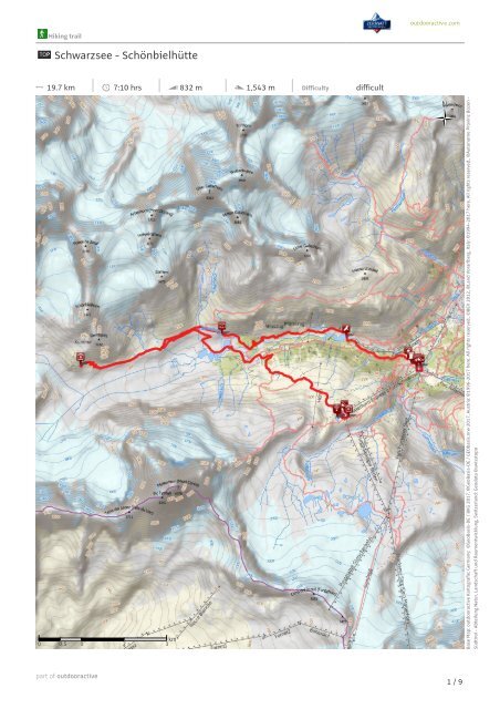
Schwarzsee - Schönbielhütte<br />
19.7 km 7:10 hrs 832 m 1,543 m Difficulty difficult<br />
Base Map: outdooractive Kartografie; Germany: ©GeoBasis-DE / BKG 2017, ©GeoBasis-DE / GEObasis.nrw 2017, Austria: ©1996-2017 here. All rights reserved., ©BEV 2012, ©Land Vorarlberg, Italy: ©1994-2017 here. All rights reserved., ©Autonome Provinz Boz<strong>en</strong> -<br />
Südtirol - Abteilung Natur, Landschaft und Raum<strong>en</strong>twicklung, Switzerland: Geodata ©swisstopo<br />
1 / 9
Hiking trail<br />
Schwarzsee - Schönbielhütte<br />
outdooractive.com<br />
19.7 km 7:10 hrs 832 m 1,543 m Difficulty difficult<br />
Base Map: outdooractive Kartografie; Germany: ©GeoBasis-DE / BKG 2017, ©GeoBasis-DE / GEObasis.nrw 2017, Austria: ©1996-2017 here. All rights reserved., ©BEV 2012, ©Land Vorarlberg, Italy: ©1994-2017 here. All rights reserved., ©Autonome Provinz Boz<strong>en</strong> -<br />
Südtirol - Abteilung Natur, Landschaft und Raum<strong>en</strong>twicklung, Switzerland: Geodata ©swisstopo<br />
2 / 9
Hiking trail<br />
Schwarzsee - Schönbielhütte<br />
outdooractive.com<br />
19.7 km 7:10 hrs 832 m 1,543 m Difficulty difficult<br />
Base Map: outdooractive Kartografie; Germany: ©GeoBasis-DE / BKG 2017, ©GeoBasis-DE / GEObasis.nrw 2017, Austria: ©1996-2017 here. All rights reserved., ©BEV 2012, ©Land Vorarlberg, Italy: ©1994-2017 here. All rights reserved., ©Autonome Provinz Boz<strong>en</strong> -<br />
Südtirol - Abteilung Natur, Landschaft und Raum<strong>en</strong>twicklung, Switzerland: Geodata ©swisstopo<br />
3 / 9
Hiking trail<br />
Schwarzsee - Schönbielhütte<br />
outdooractive.com<br />
19.7 km 7:10 hrs 832 m 1,543 m Difficulty difficult<br />
Base Map: outdooractive Kartografie; Germany: ©GeoBasis-DE / BKG 2017, ©GeoBasis-DE / GEObasis.nrw 2017, Austria: ©1996-2017 here. All rights reserved., ©BEV 2012, ©Land Vorarlberg, Italy: ©1994-2017 here. All rights reserved., ©Autonome Provinz Boz<strong>en</strong> -<br />
Südtirol - Abteilung Natur, Landschaft und Raum<strong>en</strong>twicklung, Switzerland: Geodata ©swisstopo<br />
4 / 9
Hiking trail<br />
Schwarzsee - Schönbielhütte<br />
outdooractive.com<br />
19.7 km 7:10 hrs 832 m 1,543 m Difficulty difficult<br />
Base Map: outdooractive Kartografie; Germany: ©GeoBasis-DE / BKG 2017, ©GeoBasis-DE / GEObasis.nrw 2017, Austria: ©1996-2017 here. All rights reserved., ©BEV 2012, ©Land Vorarlberg, Italy: ©1994-2017 here. All rights reserved., ©Autonome Provinz Boz<strong>en</strong> -<br />
Südtirol - Abteilung Natur, Landschaft und Raum<strong>en</strong>twicklung, Switzerland: Geodata ©swisstopo<br />
5 / 9
Hiking trail<br />
Schwarzsee - Schönbielhütte<br />
outdooractive.com<br />
Road surface<br />
Elevation profile<br />
Asphalt<br />
1.1 km<br />
Gravel<br />
4.9 km<br />
Way<br />
0.9 km<br />
Path<br />
12.2 km<br />
Street<br />
0.5 km<br />
Tour data<br />
Best time of year<br />
Ratings<br />
Hiking Trail<br />
Difficulty<br />
difficult<br />
Authors<br />
Distance<br />
19.7 km<br />
Stamina<br />
Experi<strong>en</strong>ce<br />
Duration<br />
7:10 hrs<br />
Technique<br />
Landscape<br />
Asc<strong>en</strong>t<br />
832 m<br />
Altitude<br />
Desc<strong>en</strong>t<br />
1543 m<br />
More tour data<br />
Properties<br />
Nice views<br />
Faunistic highlights<br />
Botanical highlights<br />
Awards (& Accessibility)<br />
With refreshm<strong>en</strong>t stops<br />
Zermatt Tourismus<br />
Updated: 2016-07-18<br />
Geological highlights<br />
Tour route<br />
Mountain railway<br />
asc<strong>en</strong>t/desc<strong>en</strong>t<br />
Source<br />
Zermatt Tourismus<br />
Bahnhofplatz 5<br />
3920 Zermatt<br />
Phone +41 27 966 81 00<br />
Fax +41 27 966 81 01<br />
info@zermatt.ch<br />
http://www.zermatt.ch<br />
The trail to the Schönbiel hut is full of variety; the<br />
view from the hut of the north face of the Matterhorn<br />
is breathtaking.<br />
The name says it all. In the Zermatt dialect, Schönbiel<br />
means “beautiful small plateau on a mound". From the<br />
mound on which the Schönbiel hut stands, the view of<br />
the Matterhorn is unforgettable, like in a dream. And as<br />
happ<strong>en</strong>s in dreams, the mood can change dramatically:<br />
dep<strong>en</strong>ding on weather, the mighty Matterhorn with its<br />
soaring north face can sudd<strong>en</strong>ly seem distinctly scary.<br />
The path to the hut leads across a great variety of<br />
mountain landscapes: t<strong>en</strong>ded alpine pastures, the<br />
6 / 9
Hiking trail<br />
Schwarzsee - Schönbielhütte<br />
outdooractive.com<br />
gravelly terrain of the former tongue of the Zmutt<br />
Glacier, terminal moraine lakes, a reservoir with a<br />
hydroelectric power plant, large lateral moraines. On<br />
the way back to Furi, the path leads across alpine<br />
pastures with cows and through mixed forest of larch<br />
and Swiss stone pine.<br />
●<br />
●<br />
Waterfall: Arb<strong>en</strong>bach falls<br />
Chance to see wild animals<br />
Author's recomm<strong>en</strong>dation<br />
You must take along your camera to make a<br />
picture of the impressive, steep Matterhorn<br />
north wall.<br />
Additional information and recomm<strong>en</strong>dations<br />
are available from the guest information c<strong>en</strong>tre<br />
on Bahnhofplatz (by the railway station).<br />
Turn-by-turn directions<br />
Schwarzsee - Innerer Stafel (reservoir) - Schönbiel hut -<br />
Chalbermatt<strong>en</strong> - Zmutt - Furi<br />
Starting point / trailhead<br />
Schwarzsee (2'583 m)<br />
Coordinates:<br />
Geogr. 45.991806 N 7.709100 E<br />
UTM 32T 400028 5093947<br />
Point of arrival<br />
Schönbielhütte SAC (2'694 m)<br />
Safety information<br />
●<br />
●<br />
●<br />
●<br />
Plan every mountain tour carefully and adapt to<br />
participants’ fitness level as well as the weather<br />
and season.<br />
Weather conditions can change quickly in the<br />
mountains. Appropriate clothing is therefore<br />
ess<strong>en</strong>tial, along with adequate supplies of food<br />
and water. In uncertain weather, turn back in<br />
good time.<br />
Inform others of planned route, and wh<strong>en</strong>ever<br />
possible avoid going alone.<br />
Do not leave the marked routes; do not v<strong>en</strong>ture<br />
onto glaciers without a mountain guide.<br />
●<br />
●<br />
●<br />
It is forbidd<strong>en</strong> to walk on the ski pistes.<br />
Please be considerate to other walkers and to<br />
plants and animals.<br />
Take note of the warning signs drawing att<strong>en</strong>tion<br />
to the constant danger in river beds and along<br />
watercourses below dams and reservoirs.<br />
Equipm<strong>en</strong>t<br />
We recomm<strong>en</strong>d:<br />
●<br />
●<br />
●<br />
Good footwear<br />
Hiking poles (optional)<br />
Clothing suitable for the weather (always carry a<br />
waterproof)<br />
Additional information<br />
Map<br />
A walking map (1:25,000) is available from Zermatt<br />
Tourism’s guest information c<strong>en</strong>tre, along with<br />
brochures containing tips and recomm<strong>en</strong>dations.<br />
Literature<br />
"Orts- und Flurnam<strong>en</strong> der Gemeinde Zermatt", Klaus<br />
Jul<strong>en</strong> und weitere, 1995. Erhältlich in der<br />
Buchhandlung ZAP in Zermatt. "Zermatter Sag<strong>en</strong> und<br />
Leg<strong>en</strong>d<strong>en</strong>", Karl Lehner, Neuauflage von 1982, ZAP CH-<br />
3900 Brig, ohne ISBN-Nummer "Der Wächter des<br />
Matterhorns – mein Leb<strong>en</strong> auf der Hörnlihütte", Kurt<br />
Lauber. Droemer Verlag 2012. Deutsch, evtl. Japanisch.<br />
ISBN 978-3-426-27573-3.<br />
Getting There<br />
Public transport<br />
By train to the Matterhorn village: 3½ hours from Zürich<br />
airport or 4 hours from G<strong>en</strong>eva airport. Change at Visp<br />
onto the Matterhorn Gotthard Bahn (Matterhorn<br />
Gotthard Railway). From Visp, the railway leads through<br />
the Mattertal valley past idyllic small villages to<br />
Zermatt.<br />
Zermatt is also the start and finish point for the worldfamous<br />
Glacier Express panoramic train journey<br />
(Zermatt to St. Moritz or Davos).<br />
Getting there<br />
Zermatt is car-free. Private vehicles are permitted only<br />
as far as Täsch (5 km before Zermatt). The<br />
Täsch–Zermatt road is closed to the public.<br />
Onward travel to Zermatt is either by private taxi or<br />
shuttle train. Trains depart every 20 minutes; the<br />
7 / 9
Hiking trail<br />
Schwarzsee - Schönbielhütte<br />
outdooractive.com<br />
journey takes about 12 minutes, and <strong>en</strong>ds at the<br />
Bahnhofplatz in Zermatt.<br />
Parking<br />
Täsch has car parks with both covered and op<strong>en</strong>-air<br />
parking – e.g. at the Matterhorn Terminal or privately<br />
operated facilities.<br />
Onward travel: see “Getting there”.<br />
Points of Interest (13)<br />
Gondola - Valley Station<br />
Schwarzsee (cable car station)<br />
Postfach 378<br />
3920 Zermatt<br />
+41 27 966 01 01<br />
info@matterhornparadise.ch<br />
http://www.matterhornparadise.ch<br />
Source: Zermatt Tourismus<br />
Private Cabin<br />
Schwarzsee<br />
Schwarzsee<br />
3920 Zermatt<br />
+41 27 967 22 63<br />
info@<strong>schwarzsee</strong>-zermatt.ch<br />
http://www.<strong>schwarzsee</strong>-zermatt.ch<br />
Source: Zermatt Tourismus<br />
Lake<br />
Schwarzsee<br />
3920 Zermatt<br />
Source: Zermatt Tourismus<br />
Chapel<br />
Schwarzsee chapel, “Maria zum<br />
Schnee”<br />
Source: Zermatt Tourismus<br />
Photo<br />
Photopoint Schönbiel hut<br />
Stald<strong>en</strong>strasse 87<br />
3920 Zermatt<br />
+41 79 447 41 87<br />
Source: Zermatt Tourismus<br />
Private Cabin<br />
Schönbielhütte<br />
Stald<strong>en</strong>strass 87<br />
3920 Zermatt<br />
+41 27 967 13 54<br />
bielti.zermatt@gmx.ch<br />
http://www.schönbielhütte.ch<br />
Source: Zermatt Tourismus<br />
Photo<br />
Arb<strong>en</strong> waterfall<br />
Source: Zermatt Tourismus<br />
Natural Monum<strong>en</strong>t<br />
Zmutt dam<br />
Source: Zermatt Tourismus<br />
Furi<br />
Mountain Restaurant<br />
Gitz-Gädi<br />
3920 Zermatt<br />
+41 27 966 28 00<br />
info@hotelsilvana.ch<br />
http://www.hotelsilvana.ch<br />
Source: Zermatt Tourismus<br />
Historical Site<br />
Hamlet of Furi<br />
Source: Zermatt Tourismus<br />
Mountain Restaurant<br />
Farmerhaus<br />
3920 Zermatt<br />
+41 27 967 39 96<br />
farmerhaus@bluewin.ch<br />
Source: Zermatt Tourismus<br />
Mountain Restaurant<br />
Furri<br />
http://scho<strong>en</strong>bielhuette.ch/de/kontakt.ht<br />
ml<br />
8 / 9
Hiking trail<br />
Schwarzsee - Schönbielhütte<br />
outdooractive.com<br />
3920 Zermatt<br />
+41 27 966 27 77<br />
furisepp@bluewin.ch<br />
http://www.zermatt/furri<br />
Source: Zermatt Tourismus<br />
Gondola - Valley Station<br />
Furi mountain station<br />
Postfach 378<br />
3920 Zermatt<br />
+41 27 966 01 01<br />
info@matterhornparadise.ch<br />
http://www.matterhornparadise.ch<br />
Source: Zermatt Tourismus<br />
9 / 9