Assessing torrential endangered areas in Bavaria – consideration of log jams at culverts and bridges
According to the Bavarian Water Act there is an obligation for the water management authorities to determine torrential endangered areas. In a legal sense these areas are primarily potential flood areas however under consideration of typical torrential characteristics. Especially the involvement of solids in the process has to be regarded. Therefore a standardized modular approach to assess torrential hazards was developed at the Bavarian Environment Agency.
According to the Bavarian Water Act there is an obligation for the water management authorities to determine torrential endangered areas. In a legal sense these areas are primarily potential flood areas however under consideration of typical torrential characteristics. Especially the involvement of solids in the process has to be regarded. Therefore a standardized modular approach to assess torrential hazards was developed at the Bavarian Environment Agency.
You also want an ePaper? Increase the reach of your titles
YUMPU automatically turns print PDFs into web optimized ePapers that Google loves.
<strong>Assess<strong>in</strong>g</strong> <strong>torrential</strong> <strong>endangered</strong> <strong>areas</strong> <strong>in</strong> <strong>Bavaria</strong> <strong>–</strong><br />
<strong>consider<strong>at</strong>ion</strong> <strong>of</strong> <strong>log</strong> <strong>jams</strong> <strong>at</strong> <strong>culverts</strong> <strong>and</strong> <strong>bridges</strong><br />
Peter DRESSEL 1 , Peter WAGNER 2 <strong>and</strong> Andreas RIMBOECK 2*<br />
1 Eng<strong>in</strong>eer<strong>in</strong>g consultants aquasoli (Haunert<strong>in</strong>ger Str. 1a, 83313 Siegsdorf, Germany)<br />
2 <strong>Bavaria</strong>n Environment Agency (Buergermeister-Ulrich-Str. 160, 86179 Augsburg, Germany)<br />
*Correspond<strong>in</strong>g author. E-mail: Andreas.rimboeck@lfu.bayern.de<br />
Accord<strong>in</strong>g to the <strong>Bavaria</strong>n W<strong>at</strong>er Act there is an oblig<strong>at</strong>ion for the w<strong>at</strong>er management authorities to determ<strong>in</strong>e <strong>torrential</strong><br />
<strong>endangered</strong> <strong>areas</strong>. In a legal sense these <strong>areas</strong> are primarily potential flood <strong>areas</strong> however under <strong>consider<strong>at</strong>ion</strong> <strong>of</strong> typical<br />
<strong>torrential</strong> characteristics. Especially the <strong>in</strong>volvement <strong>of</strong> solids <strong>in</strong> the process has to be regarded. Therefore a<br />
st<strong>and</strong>ardized modular approach to assess <strong>torrential</strong> hazards was developed <strong>at</strong> the <strong>Bavaria</strong>n Environment Agency. In the<br />
approach bedload <strong>and</strong> woody debris are be<strong>in</strong>g considered as two separ<strong>at</strong>e components. This procedure enables a<br />
system<strong>at</strong>ic <strong>and</strong> transparent determ<strong>in</strong><strong>at</strong>ion <strong>of</strong> the design event, the bedload supplements as well as the effects <strong>of</strong> woody<br />
debris <strong>and</strong> therefore establishes comparability <strong>of</strong> the results. Dur<strong>in</strong>g the hazard assessment an evalu<strong>at</strong>ion <strong>of</strong> potential<br />
problems result<strong>in</strong>g from woody debris <strong>in</strong> relevant zones (<strong>areas</strong> <strong>of</strong> sp<strong>at</strong>ial plann<strong>in</strong>g) takes place. A method which<br />
quantifies the potentially accumul<strong>at</strong><strong>in</strong>g woody debris <strong>in</strong> the torrent c<strong>at</strong>chment area was developed for this purpose.<br />
Potential loc<strong>at</strong>ions for <strong>log</strong> <strong>jams</strong> are recorded with a st<strong>and</strong>ardized form. On this basis, the dangers for <strong>log</strong> <strong>jams</strong> <strong>at</strong> the<br />
<strong>in</strong>dividual structures are c<strong>at</strong>egorized. Subsequently hydraulic calcul<strong>at</strong>ion is done with a 2D hydraulic model. There<br />
bedload is considered by a surcharge on the clear w<strong>at</strong>er hydrograph <strong>and</strong> <strong>log</strong> <strong>jams</strong> or bedload depositions resp. erosions<br />
are considered by a change <strong>of</strong> the model (ris<strong>in</strong>g or lower<strong>in</strong>g the torrent bed or closure <strong>of</strong> bridge).<br />
Key words: woody debris, <strong>log</strong> jam, risk assessment, 2D hydraulic model<strong>in</strong>g<br />
1. TORRENTIAL ENDANGERED AREAS<br />
Subject to Article 46 <strong>of</strong> the <strong>Bavaria</strong>n W<strong>at</strong>er Act,<br />
w<strong>at</strong>er management authorities are obliged to<br />
determ<strong>in</strong>e <strong>torrential</strong> <strong>endangered</strong> <strong>areas</strong>. They further<br />
have to be legally set as regul<strong>at</strong>ion by the district<br />
<strong>of</strong>fice. Torrential <strong>endangered</strong> <strong>areas</strong> are floodpla<strong>in</strong>s<br />
<strong>in</strong>und<strong>at</strong>ed by a 100-year-flood tak<strong>in</strong>g <strong>in</strong>to<br />
<strong>consider<strong>at</strong>ion</strong> the characteristics <strong>of</strong> torrents (design<br />
event).<br />
In the determ<strong>in</strong><strong>at</strong>ion <strong>of</strong> <strong>torrential</strong> <strong>endangered</strong><br />
<strong>areas</strong> solid m<strong>at</strong>erials like bedload <strong>and</strong> woody debris<br />
play a decisive role <strong>in</strong> the modular system applied.<br />
The <strong>Bavaria</strong>n Environment Agency identified resp.<br />
developed st<strong>and</strong>ardized st<strong>at</strong>e-<strong>of</strong>-the-art methods to<br />
deal with these issues.<br />
This paper focuses on the role <strong>of</strong> woody debris <strong>in</strong><br />
the procedure <strong>of</strong> determ<strong>in</strong><strong>in</strong>g <strong>torrential</strong> <strong>endangered</strong><br />
<strong>areas</strong>. Consistent with the practice <strong>in</strong><br />
flood-<strong>endangered</strong> <strong>areas</strong> <strong>and</strong> floodpla<strong>in</strong>s the <strong>areas</strong><br />
affected by <strong>torrential</strong> events <strong>of</strong> high as well as low<br />
occurrence probability are displayed <strong>in</strong> the form <strong>of</strong><br />
susceptibility maps. Apart from temporarily high<br />
discharge, particularly the <strong>in</strong>volvement <strong>of</strong> solids <strong>in</strong><br />
the process is regarded as dist<strong>in</strong>ctive for torrents.<br />
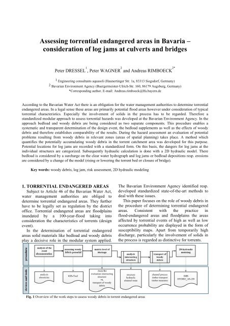
Fig. 1 Overview <strong>of</strong> the work steps to assess woody debris <strong>in</strong> torrent <strong>endangered</strong> <strong>areas</strong>
2. WOODY DEBRIS IN HAZARD<br />
ANALYSIS<br />
Possible hazards due to woody debris are<br />
evalu<strong>at</strong>ed <strong>in</strong> l<strong>in</strong>e with the hazard analysis <strong>of</strong><br />
<strong>torrential</strong> c<strong>at</strong>chments. The term “woody debris”<br />
covers all wood be<strong>in</strong>g transported <strong>in</strong> the w<strong>at</strong>er<br />
dur<strong>in</strong>g a flood event. At both n<strong>at</strong>ural <strong>and</strong> artificial<br />
constrictions this can lead to <strong>log</strong> <strong>jams</strong> caus<strong>in</strong>g<br />
tremendous damage <strong>in</strong> hous<strong>in</strong>g as well as <strong>in</strong>dustrial<br />
<strong>areas</strong>. Hereafter the st<strong>and</strong>ardized procedure for<br />
consider<strong>in</strong>g woody debris <strong>in</strong> hazard analysis is<br />
outl<strong>in</strong>ed <strong>in</strong> Fig. 1. Follow<strong>in</strong>g the steps are described<br />
<strong>in</strong> detail.<br />
programmed GIS-tool <strong>and</strong> f<strong>in</strong>ish<strong>in</strong>g with an<br />
Excel-spreadsheet. The approach developed for this<br />
purpose is depicted <strong>in</strong> Fig. 2. The required<br />
workflow consists <strong>of</strong> the follow<strong>in</strong>g steps which are<br />
commented on below [Meyer & Rimböck 2014].<br />
(a) Collection <strong>of</strong> <strong>in</strong>put d<strong>at</strong>a<br />
(b) Autom<strong>at</strong>ed GIS-based d<strong>at</strong>a process<strong>in</strong>g us<strong>in</strong>g<br />
the woody-debris-tool<br />
(c) Calcul<strong>at</strong>ion <strong>of</strong> woody debris potential us<strong>in</strong>g<br />
the Excel-spreadsheet<br />
2.1 ANALSYING THE EVENT<br />
DOCUMENTATION<br />
Initially an evalu<strong>at</strong>ion whether woody debris<br />
played a role <strong>in</strong> past events <strong>and</strong> whether it lead to<br />
problems has to be carried out. Further it has to be<br />
exam<strong>in</strong>ed if the problem is still relevant or if any<br />
further hazards have to be considered. Only if the<br />
prelim<strong>in</strong>ary works show <strong>in</strong>dic<strong>at</strong>ions for an<br />
endangerment by woody debris, it has to be<br />
considered <strong>in</strong> the follow<strong>in</strong>g.<br />
2.2 ASSESSING WOODY DEBRIS<br />
POTENTIAL<br />
2.2.1 St<strong>at</strong>us quo<br />
So far the quantity <strong>of</strong> woody debris was either<br />
calcul<strong>at</strong>ed us<strong>in</strong>g empirical formulas or estim<strong>at</strong>ed by<br />
experts <strong>in</strong> the course <strong>of</strong> a field survey <strong>of</strong> the<br />
c<strong>at</strong>chment. Whereas the first holds major<br />
uncerta<strong>in</strong>ties, the l<strong>at</strong>ter is time consum<strong>in</strong>g. Other<br />
methods such as the “Aerial photograph-based<br />
procedure for the estim<strong>at</strong>ion <strong>of</strong> woody debris<br />
potential <strong>in</strong> <strong>torrential</strong> c<strong>at</strong>chments” developed by<br />
[Rimböck 2001] have to be adapted due to technical<br />
<strong>in</strong>nov<strong>at</strong>ions.<br />
Now, an extensive d<strong>at</strong>a base is available which<br />
can be used to quantify woody debris potential.<br />
Among the d<strong>at</strong>a are hazard susceptibility maps,<br />
maps on potential geo<strong>log</strong>ical hazards, forest d<strong>at</strong>a<br />
<strong>and</strong> slope <strong>in</strong>cl<strong>in</strong><strong>at</strong>ions. They are all digitally<br />
available <strong>and</strong> can be displayed <strong>in</strong> a GIS.<br />
A new approach is represented by a GIS-tool<br />
<strong>in</strong>vented by the <strong>Bavaria</strong>n Agency Adm<strong>in</strong>istr<strong>at</strong>ion<br />
us<strong>in</strong>g the d<strong>at</strong>a stock systemically to provide a first<br />
estim<strong>at</strong>ion. This should be verified or falsified <strong>in</strong> the<br />
follow<strong>in</strong>g (oblig<strong>at</strong>ory) field survey.<br />
2.2.2 Quantific<strong>at</strong>ion <strong>of</strong> woody debris<br />
potential<br />
Initially the quantific<strong>at</strong>ion <strong>of</strong> woody debris<br />
potential is achieved us<strong>in</strong>g a specifically<br />
Fig. 2 Basic concept <strong>of</strong> GIS-based estim<strong>at</strong>ion <strong>of</strong> the amount <strong>of</strong><br />
woody debris: Del<strong>in</strong>e<strong>at</strong>ion <strong>of</strong> <strong>in</strong>put d<strong>at</strong>a, model parts <strong>and</strong><br />
<strong>in</strong>termedi<strong>at</strong>e <strong>and</strong> f<strong>in</strong>al results<br />
2.2.3 Input d<strong>at</strong>a<br />
The first step is the compil<strong>at</strong>ion <strong>of</strong> <strong>in</strong>put d<strong>at</strong>a.<br />
The follow<strong>in</strong>g d<strong>at</strong>a is used <strong>in</strong> the GIS-analysis:<br />
Topographic map (scale 1:25’000):<br />
Def<strong>in</strong>ition <strong>of</strong> a coarse frame <strong>of</strong> the c<strong>at</strong>chment<br />
boundaries <strong>and</strong> the bas<strong>in</strong> dra<strong>in</strong>age po<strong>in</strong>t<br />
Digital elev<strong>at</strong>ion model (DEM) with a<br />
<br />
resolution <strong>of</strong> 5 x 5 m<br />
“Susceptibility map geo<strong>log</strong>ical risks” <strong>of</strong> the<br />
<strong>Bavaria</strong>n Alps (scale = 1:25’000): provides<br />
<strong>in</strong>form<strong>at</strong>ion on <strong>areas</strong> <strong>endangered</strong> by<br />
l<strong>and</strong>slides<br />
WINALP-map [Reger <strong>and</strong> Ewald 2011],<br />
(scale = 1:25’000): provides <strong>in</strong>form<strong>at</strong>ion on
forest types with<strong>in</strong> the <strong>torrential</strong> c<strong>at</strong>chments;<br />
grow<strong>in</strong>g stocks <strong>of</strong> wood are assigned to the<br />
different forest types based on physical<br />
<strong>in</strong>ventory d<strong>at</strong>a<br />
2.2.4 GIS-based d<strong>at</strong>a process<strong>in</strong>g<br />
The GIS-tool autom<strong>at</strong>ically identifies the woody<br />
debris potential for each partial c<strong>at</strong>chment (<strong>in</strong><br />
general for each 1000 m <strong>of</strong> channel length) based on<br />
the design event. The autom<strong>at</strong>ic d<strong>at</strong>a process<strong>in</strong>g is<br />
carried out <strong>in</strong> the follow<strong>in</strong>g 4 steps resp. submodels:<br />
Submodel I <strong>–</strong> identific<strong>at</strong>ion <strong>of</strong> the hydro<strong>log</strong>ical<br />
c<strong>at</strong>chment <strong>and</strong> river channel<br />
Based on topographic maps the relevant area is<br />
roughly loc<strong>at</strong>ed <strong>and</strong> the bas<strong>in</strong> dra<strong>in</strong>age po<strong>in</strong>t is<br />
def<strong>in</strong>ed. The bas<strong>in</strong> dra<strong>in</strong>age po<strong>in</strong>t is the position<br />
where discharge from the c<strong>at</strong>chment is fed <strong>in</strong>to the<br />
2D hydraulic model. The 2D hydraulic model<br />
usually covers build<strong>in</strong>g <strong>areas</strong> or l<strong>and</strong> th<strong>at</strong> is<br />
potentially suitable for hous<strong>in</strong>g <strong>and</strong>/or economic<br />
activities.<br />
In the second step, the hydro<strong>log</strong>ical c<strong>at</strong>chment is<br />
autom<strong>at</strong>ically identified on the basis <strong>of</strong> the digital<br />
elev<strong>at</strong>ion model (DEM), the rough c<strong>at</strong>chment<br />
boundaries <strong>and</strong> the bas<strong>in</strong> dra<strong>in</strong>age po<strong>in</strong>t.<br />
Further the stretch <strong>of</strong> river relevant for woody<br />
debris transport is identified. For this purpose only<br />
those stretches are considered where woody debris<br />
transport is possible. Fig. 3 shows the result <strong>of</strong> the<br />
analysis by Submodel I.<br />
deactiv<strong>at</strong>ed if not appropri<strong>at</strong>e for a particular<br />
loc<strong>at</strong>ion.<br />
a) Erosion <strong>of</strong> forest covered riverbanks<br />
b) Bank erosion<br />
c) L<strong>and</strong>slide<br />
d) W<strong>in</strong>dthrow<br />
Erosion <strong>of</strong> forest covered riverbanks: This<br />
process is restricted to a narrow zone accompany<strong>in</strong>g<br />
the riverbanks. The correspond<strong>in</strong>g process <strong>areas</strong> are<br />
gener<strong>at</strong>ed us<strong>in</strong>g a buffer represent<strong>in</strong>g the channel<br />
width <strong>at</strong> flood discharge. The flood channel width is<br />
set to 10 m as default. It can be adjusted manually if<br />
further <strong>in</strong>form<strong>at</strong>ion is available from hydraulic<br />
simul<strong>at</strong>ions.<br />
Bank erosion: Areas where bank erosion is<br />
possible are normally part <strong>of</strong> the default flood<br />
channel width <strong>of</strong> 10 m (see above). Bank erosion<br />
zones beyond this extent have to be added manually<br />
(cp. Fig. 5). In these cases the model doubles the<br />
buffer width <strong>and</strong> a 20 m width is regarded.<br />
L<strong>and</strong>slide: The <strong>areas</strong> affected by l<strong>and</strong>slides<br />
mapped <strong>in</strong> the susceptibility maps <strong>of</strong> the <strong>Bavaria</strong>n<br />
Alps constitute the basis for the identific<strong>at</strong>ion <strong>of</strong><br />
l<strong>and</strong>slide-rel<strong>at</strong>ed process-<strong>areas</strong>. The woody debris<br />
GIS-tool selects those l<strong>and</strong>slides reach<strong>in</strong>g the<br />
channel sections as relevant for woody debris<br />
transport.<br />
W<strong>in</strong>dthrow: Storm events can cause the <strong>in</strong>put <strong>of</strong><br />
woody debris <strong>in</strong>to the channel from the adjo<strong>in</strong><strong>in</strong>g<br />
slopes up to a distance <strong>of</strong> one tree-length<br />
[H<strong>and</strong>sch<strong>in</strong> <strong>and</strong> Duss 1997]. At steep slopes <strong>log</strong>s<br />
from a distance <strong>of</strong> up to two tree-lengths can reach<br />
the channel. The identific<strong>at</strong>ion <strong>of</strong> the affected <strong>areas</strong><br />
is achieved autom<strong>at</strong>ically by gener<strong>at</strong><strong>in</strong>g slope angle<br />
classes based on the DEM.<br />
Fig. 3 Hydro<strong>log</strong>ical c<strong>at</strong>chment (red) <strong>and</strong> river stretches relevant<br />
for woody-debris-transport (blue). The black triangle marks the<br />
previously def<strong>in</strong>ed bas<strong>in</strong> dra<strong>in</strong>age po<strong>in</strong>t<br />
Submodel II <strong>–</strong> determ<strong>in</strong><strong>at</strong>ion <strong>of</strong> process <strong>areas</strong><br />
The <strong>areas</strong> from which woody debris can be<br />
brought <strong>in</strong>to the channel <strong>in</strong> case <strong>of</strong> an event are<br />
identified as process surface <strong>areas</strong>. In Submodel II<br />
these <strong>areas</strong> are disclosed by blend<strong>in</strong>g <strong>and</strong> analys<strong>in</strong>g<br />
extensive geosp<strong>at</strong>ial d<strong>at</strong>a cover<strong>in</strong>g all topics relevant<br />
for woody debris transport.<br />
Therefore the follow<strong>in</strong>g important processes<br />
accord<strong>in</strong>g to [Rickli <strong>and</strong> Bucher 2006] are<br />
considered, which have been implemented <strong>in</strong>to the<br />
woody debris GIS-tool. Each can optionally be<br />
Fig. 4 Identific<strong>at</strong>ion <strong>of</strong> process-relevant <strong>areas</strong>:<br />
W<strong>in</strong>dthrow-affected <strong>areas</strong> with a distance <strong>of</strong> one tree-length from<br />
the channel are depicted <strong>in</strong> green. The <strong>areas</strong> rel<strong>at</strong>ed to erosion <strong>of</strong><br />
forest covered riverbanks are shown <strong>in</strong> blue. Bank erosion<br />
rel<strong>at</strong>ed-<strong>areas</strong> are plotted <strong>in</strong> orange. In this example, no l<strong>and</strong>slide<br />
reaches the channel
Submodel III <strong>–</strong> gener<strong>at</strong>ion <strong>of</strong> potential woody<br />
debris deposits <strong>and</strong> subc<strong>at</strong>chments<br />
In order to model transport <strong>and</strong> deposition <strong>of</strong><br />
woody debris, Submodel III autom<strong>at</strong>ically cre<strong>at</strong>es<br />
deposition po<strong>in</strong>ts <strong>at</strong> <strong>in</strong>tervals <strong>of</strong> 1.000 m along the<br />
channel section relevant for woody debris transport<br />
(cp. Fig. 5). It is additionally possible to choose<br />
known constrictions or deposition zones manually.<br />
These po<strong>in</strong>ts are subsequently used for the<br />
identific<strong>at</strong>ion <strong>of</strong> subc<strong>at</strong>chments.<br />
Fig. 5 Gener<strong>at</strong><strong>in</strong>g the subc<strong>at</strong>chments based on the deposition<br />
po<strong>in</strong>ts (yellow po<strong>in</strong>t symbols)<br />
Submodel IV <strong>–</strong> assess<strong>in</strong>g woody debris potential<br />
for the subc<strong>at</strong>chments<br />
Submodel IV (cp. Fig. 6) assigns the<br />
process-rel<strong>at</strong>ed <strong>areas</strong> from Submodel II to each<br />
subc<strong>at</strong>chment derived <strong>in</strong> Submodel III. Eventually<br />
the relevant <strong>areas</strong> are multiplied with the<br />
correspond<strong>in</strong>g stock-<strong>of</strong>-wood d<strong>at</strong>a from the<br />
WINALP-d<strong>at</strong>aset. As a f<strong>in</strong>al result the<br />
GIS-woody-debris-tool provides a dbf-file for each<br />
subc<strong>at</strong>chment. The file conta<strong>in</strong>s the woody debris<br />
potentials <strong>of</strong> each <strong>in</strong>put process <strong>and</strong> can be directly<br />
imported <strong>in</strong>to the Excel-spreadsheet for further<br />
calcul<strong>at</strong>ion.<br />
Fig. 6 Clipp<strong>in</strong>g the process-rel<strong>at</strong>ed <strong>areas</strong> from the design<strong>at</strong>ed<br />
subc<strong>at</strong>chments<br />
2.2.5 Excel-spreadsheet for estim<strong>at</strong><strong>in</strong>g the<br />
woody debris potential<br />
The scor<strong>in</strong>g sheet templ<strong>at</strong>es conta<strong>in</strong> the woody<br />
debris potentials <strong>of</strong> each subc<strong>at</strong>chment. These<br />
potentials calcul<strong>at</strong>ed us<strong>in</strong>g the GIS-tool are<br />
multiplied <strong>in</strong> the Excel-spreadsheet with process-<br />
<strong>and</strong> region-specific reduction factors. In order not to<br />
overestim<strong>at</strong>e the quantity <strong>of</strong> wood be<strong>in</strong>g mobilized<br />
<strong>and</strong> transported, all processes <strong>in</strong>volved are weighted<br />
by an appropri<strong>at</strong>e factor.<br />
Among the crucial factors for a reduction is th<strong>at</strong><br />
not the whole woody debris potential gets mobilized<br />
<strong>and</strong> delivered <strong>in</strong>to the channel dur<strong>in</strong>g one event. The<br />
reduction factor considers the geo<strong>log</strong>ical,<br />
geomorpho<strong>log</strong>ic, topographic <strong>and</strong> silvicultural<br />
conditions with<strong>in</strong> the c<strong>at</strong>chment. Further not every<br />
process-rel<strong>at</strong>ed area (e.g. l<strong>and</strong>slides or bank erosion)<br />
will be activ<strong>at</strong>ed dur<strong>in</strong>g a s<strong>in</strong>gle event. Due to<br />
rema<strong>in</strong><strong>in</strong>g uncerta<strong>in</strong>ties <strong>in</strong> choos<strong>in</strong>g the reduction<br />
factors it is recommended to exam<strong>in</strong>e three different<br />
scenarios <strong>of</strong> frequent, average <strong>and</strong> rare occurrence.<br />
In the last step the probability for transport resp.<br />
deposition is considered: Only a certa<strong>in</strong> percentage<br />
<strong>of</strong> the woody debris is transported from one<br />
subc<strong>at</strong>chment to the next one downstream (default<br />
sett<strong>in</strong>g: 80 %). The rest is either deposited with<strong>in</strong><br />
the subc<strong>at</strong>chment or dis<strong>in</strong>tegr<strong>at</strong>ed <strong>in</strong>to smaller<br />
pieces so it no longer represents a hazard.<br />
The weight<strong>in</strong>g factors hold enormous degrees <strong>of</strong><br />
uncerta<strong>in</strong>ty lead<strong>in</strong>g to the result only be<strong>in</strong>g an<br />
<strong>in</strong>dic<strong>at</strong>ion. Only woody debris <strong>of</strong> n<strong>at</strong>ural orig<strong>in</strong><br />
f<strong>in</strong>ds its way <strong>in</strong>to the model described. Man-made<br />
sources <strong>of</strong> woody debris like timber yards or forest<br />
residues disposed <strong>of</strong> <strong>in</strong>to the channel have to be<br />
added manually <strong>in</strong>to the model.<br />
2.3 EVALUATION OF EVENT<br />
DOCUMENTATION<br />
The document<strong>at</strong>ion <strong>of</strong> events gives h<strong>in</strong>ts<br />
whether the regarded bridge is prone to <strong>log</strong> <strong>jams</strong> or<br />
not. If <strong>log</strong> <strong>jams</strong> have been observed previously <strong>and</strong><br />
neither the bridge’s construction has been changed<br />
nor any wood retention measures have been built<br />
s<strong>in</strong>ce, blockage has to be considered <strong>at</strong> the regarded<br />
loc<strong>at</strong>ion. The level <strong>of</strong> blockage is to be determ<strong>in</strong>ed<br />
us<strong>in</strong>g the m<strong>at</strong>rix described <strong>in</strong> chapter 2.4. A<br />
m<strong>in</strong>imum level <strong>of</strong> blockage <strong>of</strong> 25 % is to be applied<br />
<strong>in</strong> these cases.<br />
If the event document<strong>at</strong>ion can be considered as<br />
complete <strong>and</strong> comprises <strong>at</strong> least 2 events <strong>in</strong> the<br />
range <strong>of</strong> a design event <strong>and</strong> no <strong>log</strong> <strong>jams</strong> have been<br />
recorded, the risk <strong>of</strong> the bridge be<strong>in</strong>g blocked by<br />
woody debris can be considered as negligible.<br />
In cases when no <strong>log</strong> <strong>jams</strong> are recorded <strong>at</strong> a<br />
certa<strong>in</strong> bridge or culvert, but it is uncerta<strong>in</strong> how far<br />
the event document<strong>at</strong>ion can be trusted, the m<strong>at</strong>rix<br />
described <strong>in</strong> chapter 2.4 is to be applied without<br />
limit<strong>at</strong>ions.<br />
2.4 MATRIX LEVEL OF BLOCKAGE<br />
The specific woody debris load determ<strong>in</strong>ed by
the GIS-tool does not allow draw<strong>in</strong>g conclusions on<br />
the probability <strong>of</strong> a <strong>log</strong> jam on its own. Thus both<br />
aspects, woody debris transport <strong>and</strong> the<br />
characteristics <strong>of</strong> the <strong>in</strong>tersect<strong>in</strong>g structures have to<br />
be r<strong>at</strong>ed.<br />
2.4.1 ANALYSING INTERSECTING<br />
STRUCTURES<br />
In the course <strong>of</strong> hazard assessment, the<br />
<strong>in</strong>tersect<strong>in</strong>g structure has to be classified concern<strong>in</strong>g<br />
the risk for a potential <strong>log</strong> jam. The follow<strong>in</strong>g three<br />
aspects have to be considered (cp. Fig. 9):<br />
<strong>in</strong>tersect<strong>in</strong>g structure<br />
hydraulics<br />
channel route<br />
2.4.1.1 Intersect<strong>in</strong>g structure<br />
In most cases, the first bridge with<strong>in</strong> the<br />
hydraulic model poses the highest risk for be<strong>in</strong>g<br />
jammed by woody debris compared to <strong>bridges</strong><br />
further downstream [Gschnitzer et al. 2014].<br />
Corners, rims, sharp bends <strong>and</strong> structural elements<br />
protrud<strong>in</strong>g <strong>in</strong>to the stream channel <strong>in</strong>crease the risk<br />
<strong>of</strong> <strong>log</strong> <strong>jams</strong> <strong>at</strong> constructions. The same applies to<br />
pipes protrud<strong>in</strong>g <strong>in</strong>to the channel section on the<br />
upstream-fac<strong>in</strong>g side <strong>of</strong> the bridge.<br />
Fig. 8 M<strong>at</strong>rix level <strong>of</strong> blockage for 2D hydraulic model<strong>in</strong>g:<br />
Comb<strong>in</strong><strong>at</strong>ion between evalu<strong>at</strong>ion <strong>in</strong>tersect<strong>in</strong>g structures (y-axis)<br />
<strong>and</strong> transport <strong>of</strong> woody debris (x-axis)<br />
2.4.1.2 hydraulics<br />
A first hydraulic simul<strong>at</strong>ion is done with the<br />
design hydrograph <strong>in</strong>clud<strong>in</strong>g bedload surcharge.<br />
This calcul<strong>at</strong>ion provides important d<strong>at</strong>a for<br />
evalu<strong>at</strong>ion <strong>of</strong> the risk <strong>of</strong> <strong>log</strong> <strong>jams</strong>. Apart from the<br />
Fig. 9 Evalu<strong>at</strong>ion <strong>in</strong>tersect<strong>in</strong>g structure<br />
<strong>Assess<strong>in</strong>g</strong> the <strong>in</strong>teraction <strong>of</strong> these aspects by<br />
means <strong>of</strong> a m<strong>at</strong>rix designed for this purpose allows<br />
determ<strong>in</strong><strong>in</strong>g the grade <strong>of</strong> closure needed for<br />
subsequent 2D hydraulic simul<strong>at</strong>ion. The grade <strong>of</strong><br />
closure characterizes the decrease <strong>of</strong> the bridge’s<br />
cross section.<br />
degree <strong>of</strong> freeboard, rel<strong>at</strong>ive flow depth <strong>and</strong> the<br />
Froude number have to be c<strong>at</strong>egorized as well (cp.<br />
Fig. 9). Knowledge <strong>of</strong> the freeboard dur<strong>in</strong>g a<br />
100-year event can be considered as a key element<br />
<strong>in</strong> hazard evalu<strong>at</strong>ion. A freeboard <strong>of</strong> less than 0.5 m<br />
is to be considered as critical. Furthermore rel<strong>at</strong>ive<br />
flow depth <strong>and</strong> Froude number obta<strong>in</strong>ed <strong>in</strong> the 2D
hydraulic simul<strong>at</strong>ion provide valuable <strong>in</strong>form<strong>at</strong>ion<br />
<strong>and</strong> have to be classified <strong>in</strong>to one <strong>of</strong> the three<br />
classes uncritical, moder<strong>at</strong>e or critical.<br />
2.4.1.3 Channel route<br />
A cont<strong>in</strong>uous stream channel near the culvert<br />
reduces the probability <strong>of</strong> woody debris gett<strong>in</strong>g<br />
stuck <strong>and</strong> thus caus<strong>in</strong>g a <strong>log</strong> jam. On the contrary<br />
expansion or narrow<strong>in</strong>g <strong>of</strong> the channel section as<br />
well as drops <strong>in</strong> the channel <strong>in</strong>crease the probability<br />
<strong>of</strong> <strong>log</strong> <strong>jams</strong> due to the vary<strong>in</strong>g flow conditions <strong>and</strong><br />
hydraulic framework conditions.<br />
2.4.2 TRANSPORT OF WOODY<br />
DEBRIS<br />
In order to assess woody debris transport a<br />
represent<strong>at</strong>ive stretch <strong>of</strong> about 1 km upstream <strong>of</strong> the<br />
<strong>in</strong>tersect<strong>in</strong>g structure can be taken as reference for<br />
estim<strong>at</strong><strong>in</strong>g timber sizes. For hazard analysis a <strong>log</strong><br />
length (L) correspond<strong>in</strong>g to the m<strong>in</strong>imum channel<br />
width along the represent<strong>at</strong>ive stretch (b wo ) can be<br />
chosen as reference value [Stetter 2015]:<br />
L b<br />
wo<br />
( 1a)<br />
Furthermore the follow<strong>in</strong>g aspects have to be<br />
evalu<strong>at</strong>ed (cp. Fig. 10):<br />
channel (flow) process<br />
wood transport<br />
wood dimensions<br />
lead to frequent collisions <strong>of</strong> woody debris with the<br />
channel bed <strong>and</strong> the channel banks. This <strong>in</strong>creases<br />
the probable occurrence <strong>of</strong> <strong>log</strong> <strong>jams</strong>. The<br />
classific<strong>at</strong>ion <strong>of</strong> process type is hierarchically<br />
arranged as follows: Flood <strong>and</strong> fluvial sediment<br />
transport, hyperconcentr<strong>at</strong>ed flow <strong>and</strong> debris flow.<br />
Another factor covers the classific<strong>at</strong>ion <strong>of</strong> the<br />
<strong>in</strong>tersect<strong>in</strong>g structure. It is to be classified accord<strong>in</strong>g<br />
to the channel’s gradient. Further the bank<br />
veget<strong>at</strong>ion has to be assigned to a certa<strong>in</strong> c<strong>at</strong>egory.<br />
The method takes the effects <strong>of</strong> different habit<strong>at</strong>s<br />
<strong>in</strong>to account. Stem-form<strong>in</strong>g bank veget<strong>at</strong>ion tends to<br />
trap woody debris, thus hold<strong>in</strong>g it back <strong>and</strong><br />
prevent<strong>in</strong>g further transport. Shrub veget<strong>at</strong>ion<br />
fulfills this function as well but to a much less<br />
degree.<br />
2.4.2.2 Wood transport<br />
The parameter wood transport is significantly<br />
controlled by the amount <strong>of</strong> wood be<strong>in</strong>g transported,<br />
channel rout<strong>in</strong>g, channel roughness <strong>and</strong> course <strong>of</strong><br />
the longitud<strong>in</strong>al section. For this purpose, the flow<br />
conditions are to be evalu<strong>at</strong>ed concern<strong>in</strong>g their<br />
homogeneity. Due to frequently chang<strong>in</strong>g hydraulic<br />
conditions, highly braided channels tend to transport<br />
<strong>log</strong>s with a less critical length compared to stretched<br />
channels with nearly constant flow velocities.<br />
2.4.2.1 Channel process<br />
The c<strong>at</strong>egory channel process evalu<strong>at</strong>es process<br />
type, disposition <strong>and</strong> the relevant framework<br />
conditions for woody debris transport. For this<br />
purpose, the supposed flow process <strong>in</strong> the torrent is<br />
essential. Discharges fe<strong>at</strong>ur<strong>in</strong>g strong turbulences<br />
Fig. 10 Classific<strong>at</strong>ion <strong>of</strong> woody debris transport
2.4.2.3 Wood dimensions<br />
F<strong>in</strong>ally woody debris size (length <strong>and</strong> diameter)<br />
as well as local <strong>and</strong> hydraulic framework conditions<br />
affect the risk <strong>of</strong> jamm<strong>in</strong>g. The maximum length <strong>of</strong><br />
the <strong>log</strong>s can approxim<strong>at</strong>ely be estim<strong>at</strong>ed tak<strong>in</strong>g the<br />
m<strong>in</strong>imum channel width upstream <strong>of</strong> the bridge as a<br />
reference. A m<strong>in</strong>imum flow depth (h) <strong>of</strong> half the<br />
<strong>log</strong>s’ diameter (d) is required for woody debris<br />
transport to beg<strong>in</strong> [Imh<strong>of</strong> 2008; Lange & Bezzola<br />
2006].<br />
d<br />
h (1b<br />
)<br />
2<br />
2.5 2D HYDRAULIC MODELING<br />
The determ<strong>in</strong><strong>at</strong>ion <strong>of</strong> the <strong>torrential</strong> <strong>endangered</strong><br />
area is achieved by a 2D hydraulic simul<strong>at</strong>ion us<strong>in</strong>g<br />
the programme Hydro_AS-2D. By default a<br />
simul<strong>at</strong>ion <strong>of</strong> the basic scenario without any <strong>log</strong><br />
<strong>jams</strong> or sediment accumul<strong>at</strong>ion is carried out. A<br />
maximum <strong>of</strong> two further scenarios consider<strong>in</strong>g <strong>log</strong><br />
<strong>jams</strong>, sediment accumul<strong>at</strong>ions or both can be taken<br />
<strong>in</strong>to account <strong>and</strong> simul<strong>at</strong>ed. Additional scenarios<br />
only should be considered if they most likely occur<br />
dur<strong>in</strong>g a design event.<br />
The level <strong>of</strong> blockage def<strong>in</strong>ed <strong>in</strong> the previous<br />
steps has to be considered appropri<strong>at</strong>ely. Depend<strong>in</strong>g<br />
on the channel course two configur<strong>at</strong>ions are to be<br />
dist<strong>in</strong>guished. In curved channel courses, the <strong>log</strong><br />
jam is <strong>in</strong>corpor<strong>at</strong>ed <strong>in</strong>to the model by mov<strong>in</strong>g the<br />
bridge’s outer abutment <strong>in</strong>to the channel bed. In<br />
stretched channel courses, the lowest l<strong>in</strong>e <strong>of</strong><br />
structure is lowered by the amount needed to<br />
reproduce the level <strong>of</strong> blockage. The reduced<br />
channel section makes it possible to show effects <strong>of</strong><br />
the <strong>log</strong> jam on the extent <strong>of</strong> the flooded area.<br />
The method <strong>of</strong> determ<strong>in</strong><strong>in</strong>g the level <strong>of</strong><br />
blockage <strong>and</strong> the subsequent implement<strong>at</strong>ion <strong>in</strong>to<br />
the hydraulic model is illustr<strong>at</strong>ed <strong>in</strong> the follow<strong>in</strong>g<br />
case study.<br />
2.5.1 Case study Weissl<strong>of</strong>er, Reit im<br />
W<strong>in</strong>kl<br />
The bridge <strong>at</strong> Entfelderstrasse is the third bridge<br />
<strong>in</strong> the local area <strong>of</strong> Reit im W<strong>in</strong>kl (Upper <strong>Bavaria</strong>)<br />
cross<strong>in</strong>g the Weissl<strong>of</strong>er river (see overview <strong>in</strong> Fig.<br />
11). It is thus not regarded as the most critical one <strong>in</strong><br />
the hazard assessment. Nonetheless, it is still<br />
capable <strong>of</strong> pos<strong>in</strong>g problems s<strong>in</strong>ce there is no woody<br />
debris retention <strong>and</strong> the <strong>bridges</strong> further upstream did<br />
not show a high probability <strong>of</strong> jamm<strong>in</strong>g <strong>and</strong> thus<br />
hold<strong>in</strong>g back <strong>in</strong>com<strong>in</strong>g woody debris. Between the<br />
last bridge further upstream <strong>and</strong> the bridge <strong>at</strong><br />
Entfelderstrasse the Weissl<strong>of</strong>er’s outer bank runs<br />
along a wooded hillside toe for about 700 m. If bank<br />
erosion occurs along this stretch, woody debris is<br />
expected to accumul<strong>at</strong>e <strong>at</strong> the bridge <strong>at</strong><br />
Entfelderstrasse.<br />
Fig. 11 Overview Germany <strong>and</strong> <strong>Bavaria</strong>. The case study<br />
c<strong>at</strong>chment <strong>of</strong> the Weissl<strong>of</strong>er near Reit im W<strong>in</strong>kl, Upper <strong>Bavaria</strong>,<br />
is highlighted by a green frame<br />
Due to the bridge’s dimensions <strong>and</strong> constructive<br />
design it is regarded as a critical structure, especially<br />
as the flow depth exceeds the clearance height.<br />
Further aspects are: rough <strong>and</strong> unsurfaced channel<br />
bottom, structures upstream <strong>and</strong> downstream <strong>of</strong> the<br />
bridge. Furthermore the free surface width <strong>of</strong> the<br />
channel is wider than the bridge’s <strong>in</strong>ner width (see<br />
Fig. 12).<br />
Fig. 12 Bridge Entfelderstrasse<br />
The longitud<strong>in</strong>al section <strong>of</strong> the channel is<br />
stepped, the channel route can be classified as<br />
slightly curved. The <strong>log</strong> diameters are less than the<br />
flow depth <strong>and</strong> the maximum tree length is smaller
than the upstream channel width. This classifies the<br />
woody debris transport <strong>at</strong> the bridge’s loc<strong>at</strong>ion as<br />
moder<strong>at</strong>e.<br />
The evalu<strong>at</strong>ion <strong>of</strong> the structure <strong>and</strong> the<br />
assessment <strong>of</strong> a moder<strong>at</strong>e wood transport plotted<br />
<strong>in</strong>to the m<strong>at</strong>rix results <strong>in</strong> a blockage level <strong>of</strong> 75 %.<br />
additional <strong>in</strong>und<strong>at</strong>ion <strong>of</strong> major settled <strong>areas</strong> east <strong>of</strong><br />
the Entfelderstrasse. However, the <strong>log</strong> jam <strong>at</strong> the<br />
bridge <strong>at</strong> Entfelderstrasse does not affect the extent<br />
<strong>of</strong> the <strong>in</strong>und<strong>at</strong>ed <strong>areas</strong> along the Alpenstrasse.<br />
2.5.2 Results<br />
The first hydraulic simul<strong>at</strong>ion run considers the<br />
basic scenario without <strong>log</strong> <strong>jams</strong> or other scenarios<br />
(Fig. 13). The results show m<strong>in</strong>or flood<strong>in</strong>g near the<br />
bridge <strong>at</strong> Entfelderstrasse mostly affect<strong>in</strong>g lawns<br />
<strong>and</strong> agricultural l<strong>and</strong>. At the adjacent bridge where<br />
the Weissl<strong>of</strong>er is crossed by the Alpenstrasse, the<br />
simul<strong>at</strong>ion results show an overtopp<strong>in</strong>g <strong>of</strong> the banks<br />
result<strong>in</strong>g <strong>in</strong> major <strong>in</strong>und<strong>at</strong>ions along the<br />
Alpenstrasse. The overflow<strong>in</strong>g affects settled l<strong>and</strong> to<br />
a large extent even <strong>in</strong> the scenario with an<br />
unblocked bridge <strong>at</strong> Alpenstrasse.<br />
Fig. 14 Simul<strong>at</strong>ion result for the scenario consider<strong>in</strong>g a <strong>log</strong> jam<br />
<strong>at</strong> the bridge <strong>at</strong> Entfelderstrasse. The Entfelderstrasse bridge’s<br />
position is marked with a green dot. The bridge <strong>at</strong> Alpenstrasse<br />
is marked with a red dot<br />
Fig. 13 Simul<strong>at</strong>ion result for the default scenario without any<br />
<strong>log</strong> <strong>jams</strong> or sediment accumul<strong>at</strong>ions. The Entfelderstrasse<br />
bridge’s position is marked with a green dot. The bridge <strong>at</strong><br />
Alpenstrasse is marked with a red dot<br />
The second scenario (see Fig. 14) takes <strong>in</strong>to<br />
account the <strong>log</strong> jam <strong>at</strong> the bridge <strong>at</strong> Entfelderstrasse.<br />
Compared to the default scenario, the river overtops<br />
near the Entfelderstrasse bridge. This results <strong>in</strong> an<br />
3. CONCLUSION<br />
The <strong>torrential</strong> <strong>endangered</strong> area determ<strong>in</strong>ed by<br />
2D hydraulic simul<strong>at</strong>ion displays the range <strong>of</strong> most<br />
probable scenarios <strong>of</strong> the design event. This<br />
system<strong>at</strong>ic approach enables a reproducible<br />
determ<strong>in</strong><strong>at</strong>ion <strong>and</strong> <strong>consider<strong>at</strong>ion</strong> <strong>of</strong> possible <strong>log</strong><br />
<strong>jams</strong> <strong>and</strong> a comparability <strong>of</strong> obta<strong>in</strong>ed results is<br />
achieved.<br />
First assessments <strong>of</strong> the proposed procedure<br />
show th<strong>at</strong> the approach to calcul<strong>at</strong>e the level <strong>of</strong><br />
blockage <strong>at</strong> <strong>in</strong>tersect<strong>in</strong>g structures is feasible to<br />
document the susceptibility for blockages through<br />
woody debris <strong>at</strong> <strong>bridges</strong> or <strong>culverts</strong>.<br />
REFERENCES<br />
Gschnitzer, T., Gems, B., & Aufleger, M. (2014):<br />
Laborversuche zu Schwemmholztransport und<br />
e<strong>in</strong>hergehenden Brückenverklausungen und Erstellung e<strong>in</strong>es<br />
Leitfadens zur Berücksichtigung dieser Phänomene <strong>in</strong> der
Gefahrenzonenplanung. Innsbruck.<br />
H<strong>and</strong>sch<strong>in</strong>, W. & Duss, H. (1997): Holzprobleme an<br />
Wildbächen, 1. Phase. Liter<strong>at</strong>urstudium und Prozessanalyse,<br />
Altdorf, den 13. Oktober 1997.<br />
Imh<strong>of</strong>, M. (2008): Verklausung von Schwemmholz an Brücken.<br />
E<strong>in</strong>fluss der Abflussverhältnisse. Zürich: ETH.<br />
Lange, D., & Bezzola, G. (2006): Schwemmholz: Probleme und<br />
Lösungsansätze. Zürich: Mitteilung der Versuchsanstalt für<br />
Wasserbau, Hydro<strong>log</strong>ie und Glazio<strong>log</strong>ie. Zürich.<br />
Meyer, J. & Rimböck, A. (2014): GIS-basierter Ans<strong>at</strong>z zur<br />
Abschätzung des Schwemmholzpotenzials <strong>in</strong> Wildbächen;<br />
Intern<strong>at</strong>ionales Symposium „Wasser- und Flussbau im<br />
Alpenraum“, 25.-27.06.2014 <strong>in</strong> Zürich; Tagungspublik<strong>at</strong>ion<br />
S. 443 ff; Mitteilungen der Versuchsanstalt für Wasserbau,<br />
Hydro<strong>log</strong>ie und Glazio<strong>log</strong>ie der Eidgenössischen<br />
Technischen Hochschule Zürich Nr. 228; Zürich;<br />
Eigenverlag DOI: 10.13140/2.1.1460.5768. Richards, L.A.<br />
(1931): Capillary conduction <strong>of</strong> liquids through porous<br />
mediums, Physics, Vol. 1, pp. 318-333.<br />
Reger, B. und Ewald, J. (2011): Waldtypenkarte Bayerische<br />
Alpen. In AFZ <strong>–</strong> Der Wald (2011), 24, 14-26.<br />
Rimböck, A (2001): Luftbildbasierte Abschätzung des<br />
Schwemmholzpotentials (LASP) <strong>in</strong> Wildbächen. In:<br />
Festschrift 75 Jahre Oskar von Miller-Institut, 1926-2001:<br />
Berichte des Lehrstuhls und der Versuchsanstalt für<br />
Wasserbau und Wasserwirtschaft der technischen<br />
Universität München (2001), 91. 202-221.<br />
Stetter, F. (2014): Verkle<strong>in</strong>erungsprozesse von Schwemmholz<br />
<strong>in</strong> Gebirgsflüssen und Wildbächen. Projektarbeit. WSL,<br />
Versuchsanstalt für Wasserwirtschaft (VAW)


