AI2018-07 - Response to 2018 October 15 Administrative Inquiry

Create successful ePaper yourself
Turn your PDF publications into a flip-book with our unique Google optimized e-Paper software.
Item #13.2 <strong>AI<strong>2018</strong></strong>-<strong>07</strong><br />
ISC: Protected<br />
Memo<br />
<strong>2018</strong> November 19<br />
To:<br />
From:<br />
Mayor and Councillors<br />
Rob Spackman<br />
Direc<strong>to</strong>r, Water Resources<br />
Debra Hamil<strong>to</strong>n<br />
Direc<strong>to</strong>r, Community Planning<br />
Doug Cassidy<br />
Direc<strong>to</strong>r, Real Estate and Development Services<br />
Denise Jakal<br />
Manager, Planning & Environment<br />
Law & Legislative Services<br />
Re:<br />
<strong>Response</strong> <strong>to</strong> <strong>Administrative</strong> <strong>Inquiry</strong><br />
<strong>2018</strong> Oc<strong>to</strong>ber <strong>15</strong> Council Meeting - Highland Park Golf Course Lands<br />
Submitted by Councillor Keating<br />
Background<br />
In 2013, 1744228 Alberta Ltd. (the “Landowner”), a company of which Ajay Nehru is a Direc<strong>to</strong>r,<br />
acquired the former Highland Park Golf Course lands (the “Lands”) from the owner who originally<br />
developed the Lands as a golf course for a purchase price of $8.1 million. Several months prior<br />
<strong>to</strong> purchasing the Lands, Mr. Nehru had already participated in a pre-application enquiry<br />
regarding the Lands, at which point the challenges of developing the Lands were highlighted <strong>to</strong><br />
him by The City.<br />
In late 2014, after going through another pre-application process during which the Landowner<br />
and Water Resources had extensive discussions about the s<strong>to</strong>rmwater issues with the Lands,<br />
the Landowner submitted a land use and outline plan application. Through the application<br />
review, the Landowner indicated that they wanted <strong>to</strong> move forward quickly despite having<br />
incomplete information about the potential risks of developing this site. In electing <strong>to</strong> proceed,<br />
the Landowner assumed the risk of moving forward with a proposal that might prove <strong>to</strong> be<br />
unbuildable. This transfer of risk is reflected in the Outline Plan conditions of approval.<br />
This system of apportioning risk can only work if The City resists assuming such risks if,<br />
or when, these unknown risks become known. Otherwise, The City will effectively become<br />
12th Floor, 800 Macleod Trail S.E., Calgary, AB T2G 2M3
<strong>AI<strong>2018</strong></strong>-<strong>07</strong><br />
the guaran<strong>to</strong>r of any and all developments across the city. When the outline plan for this<br />
site was conditioned, the unknown risks that existed with respect <strong>to</strong> the impacts of the Regional<br />
Drainage Study became the Landowner’s. Specifically, the conditions required a Staged Master<br />
Drainage Plan prior <strong>to</strong> tentative plan approval, and provided that any dry pond requirements<br />
identified therein must be accommodated on the Lands. Following a close vote, the land use<br />
amendment was approved. There was extensive debate in Council about whether or not <strong>to</strong><br />
approve this land use amendment in the absence of the Regional Drainage Study, but it was<br />
noted that the outline plan conditions had been drafted <strong>to</strong> ensure that construction would not<br />
commence until the Regional Drainage Study was completed<br />
When the Confederation Park Regional Drainage Study Draft Final Report was released on June<br />
1, <strong>2018</strong>, it became clear that drainage through the Lands is a major concern, and it<br />
recommended that the feasibility of s<strong>to</strong>rmwater s<strong>to</strong>rage solutions on the Lands be explored. The<br />
risks respecting the Regional Drainage Study had materialized, and it is now clear that the<br />
Landowner will be unable <strong>to</strong> develop the Lands as contemplated in the approved outline plan.<br />
Throughout <strong>2018</strong>, The City has repeatedly communicated <strong>to</strong> the Landowner that there are two<br />
realistic paths forward:<br />
1. Proceed with its development application, preferably by meeting with The City <strong>to</strong><br />
determine how the Landowner can maximize the site’s development potential within<br />
the scope of the outline plan conditions and the limitations identified in the Regional<br />
Drainage Study; or<br />
2. Present The City with a reasonable offer of sale for the Lands.<br />
The City is not currently in a position where it needs <strong>to</strong> acquire the Lands. Right now, the Lands<br />
are functioning as a natural drainage solution and, based on the way the outline plan conditions<br />
have been drafted, no development will take place on the large portion of the Lands that sits<br />
west of Centre Street until “appropriate solutions for the entire catchment, including interim<br />
solutions <strong>to</strong> allow phased development <strong>to</strong> proceed, have been identified and implemented <strong>to</strong> the<br />
satisfaction of Water Resources.”<br />
It is possible that the ultimate solution may be a combination of options 1 and 2 above, but that<br />
will not be possible <strong>to</strong> assess until the Regional Drainage Study is finalized. The Final Report of<br />
the Regional Drainage Study is expected at the end of Q4, <strong>2018</strong>. Once that report is complete,<br />
The City will have a better idea of how much of the Lands might be impacted by a proposed<br />
regional s<strong>to</strong>rmwater drainage solution. The City will also then be in a position <strong>to</strong> discuss with the<br />
Landowner which lands may be required <strong>to</strong> be dedicated <strong>to</strong> The City as Municipal Reserve (MR),<br />
Environmental Reserve (ER), and Public Utility Lot (PUL), which lands may assist in the<br />
accommodation of regional drainage, and whether any additional lands over and above these<br />
dedications would be necessary <strong>to</strong> accommodate s<strong>to</strong>rmwater flows.<br />
<strong>Response</strong> <strong>to</strong> <strong>Administrative</strong> <strong>Inquiry</strong><br />
2
<strong>AI<strong>2018</strong></strong>-<strong>07</strong><br />
With the above background in mind, please find below Administration’s response <strong>to</strong> the<br />
<strong>Administrative</strong> <strong>Inquiry</strong> received Oc<strong>to</strong>ber <strong>15</strong>, <strong>2018</strong>.<br />
1. What is the current status of the Confederation Park Regional Drainage Study, Draft<br />
Final Report, May 31, <strong>2018</strong>?<br />
The Draft Final Report has been posted online and made available <strong>to</strong> the public. As<br />
noted above, the Final Report is underway and The City expects it <strong>to</strong> be issued by the<br />
end of Q4, <strong>2018</strong>. Once complete, the Final Report will be made available <strong>to</strong> the public in<br />
early 2019.<br />
2. The draft report recommendation is <strong>to</strong> utilize the former Highland Park golf course<br />
essentially as a s<strong>to</strong>rmwater reservoir (in the one in one hundred year event). What is<br />
the estimated cost <strong>to</strong> purchase this private land?<br />
The Draft Final Report’s recommendation <strong>to</strong>uches on the need <strong>to</strong> further explore the<br />
feasibility of acquiring all or a portion of the Lands in order <strong>to</strong> accommodate s<strong>to</strong>rage and<br />
conveyance improvements in the Confederation Creek catchment area. At this time, we<br />
do not know how much of the Lands would be impacted or where on the site the<br />
proposed s<strong>to</strong>rage solutions would be. As such, we have not yet obtained a formal<br />
appraisal of the Lands.<br />
In terms of the information available, we know that the last time a knowledgeable, willing<br />
and unpressured buyer purchased this property in an open market was in 2013 when<br />
the Lands were acquired by the Landowner for $8.1 million. Any third party buyer would<br />
be looking at the obvious challenges (an extensive, existing network of utilities that<br />
cannot be moved, City-owned PUL running through the middle of the site, sloped<br />
<strong>to</strong>pography, registrations on title, and any comments received from a pre-development<br />
application meeting with The City, if pursued), all of which were available <strong>to</strong> the<br />
Landowner at the time of its purchase.<br />
As discussed in more detail above, since the Landowner purchased the Lands:<br />
<br />
<br />
<br />
<br />
a land use amendment application for the Lands was approved by Council;<br />
an outline plan was approved by Calgary Planning Commission subject <strong>to</strong><br />
several conditions;<br />
the Draft Regional Drainage Study was released, highlighting the reality that the<br />
existing outline plan is not developable; and<br />
the real estate market in Calgary experienced a decline.<br />
All of these fac<strong>to</strong>rs would be taken in<strong>to</strong> account when valuing the Lands. Given all of the<br />
above fac<strong>to</strong>rs, it would be premature <strong>to</strong> speculate on the Lands’ market value.<br />
3. Did Administration (Water Resources) consider whether it could utilize the Cityowned<br />
lands upstream <strong>to</strong> address the s<strong>to</strong>rmwater issue, i.e. could it s<strong>to</strong>re water on<br />
the Confederation Golf Course, Confederation Park and/or Queen’s Park Cemetery<br />
3
<strong>AI<strong>2018</strong></strong>-<strong>07</strong><br />
lands? Has the cost of this option been addressed relative <strong>to</strong> the Highland Park<br />
development land purchase option?<br />
Yes, Water Resources did consider options <strong>to</strong> utilize upstream City-owned lands. The<br />
cost of upstream s<strong>to</strong>rage has not been addressed, as no viable options have been<br />
identified.<br />
Queen’s Park Cemetery is not a viable option because there is minimal s<strong>to</strong>rage space<br />
available in the cemetery that would not impact existing graves and urns. This proposed<br />
option would result in extensive flooding of existing grave sites which would have<br />
significant social, moral and operational implications.<br />
Overland flows upstream of Queen’s Park Cemetery are already fully retained and<br />
released in a controlled manner. The s<strong>to</strong>rmwater volumes entering the Lands come<br />
from the catchment areas downstream of Confederation Park Golf Course and<br />
Confederation Park as well as Queen’s Park Cemetery. Water Resources has worked<br />
collaboratively with the Landowner’s consultant, ISL Engineering, <strong>to</strong> explore additional<br />
open space s<strong>to</strong>rage options in the catchment area; however, after careful consideration<br />
by Water Resource’s consultant (Associated Engineering), it was determined that these<br />
areas offered minimal s<strong>to</strong>rage opportunities and would have a marginal impact on the<br />
water volumes entering the Lands. Water Resources and ISL mutually agreed that there<br />
are no viable upstream s<strong>to</strong>rage alternatives on City-owned land <strong>to</strong> address the volume<br />
of s<strong>to</strong>rmwater entering the Lands.<br />
Not only were these alternatives considered, but The City’s analysis with respect <strong>to</strong><br />
other potential solutions was peer-reviewed by an independent third-party,<br />
Computational Hydraulics International, who concurred with The City’s analysis. There<br />
has been extensive and repeated communication between Water Resources and ISL on<br />
this issue.<br />
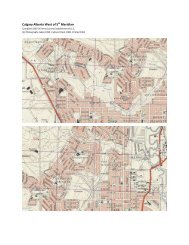
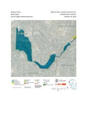
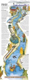
For an illustration of the catchment area and the locations of alternative s<strong>to</strong>rage<br />
solutions considered by The City and ISL, please see the map enclosed as Attachment<br />
1.<br />
4. If not analyzed, why were these existing City-owned lands with extensive open<br />
spaces, particularly for catastrophic s<strong>to</strong>rmwater events, not considered?<br />
Not applicable. Please see above.<br />
5. Is the recommended land purchase and some associated s<strong>to</strong>rmwater infrastructure<br />
included in the upcoming 2019-2022 budget discussions?<br />
No. As discussed above, the Regional Drainage Study is not yet finalized. Once the<br />
study is finalized and implementation options are determined, funding of those options<br />
would be considered within the Community Drainage Improvement Program.<br />
4
<strong>AI<strong>2018</strong></strong>-<strong>07</strong><br />
6. If not included in the upcoming proposed 4-year budget, what is the next step <strong>to</strong><br />
resolve this situation working in cooperation with the landowner of the Highland<br />
Park lands?<br />
As noted previously, there are two realistic paths forward. The Landowner has the<br />
option of continuing <strong>to</strong> pursue its development application. The City has repeatedly<br />
offered <strong>to</strong> meet with the Landowner <strong>to</strong> review and discuss the existing outline plan<br />
conditions and how the Landowner might be able <strong>to</strong> redesign the site with those<br />
conditions in mind. The other option is for the Landowner <strong>to</strong> make The City a<br />
reasonable offer of sale based on the current state of the Lands and the known<br />
constraints on development. City Administration continues <strong>to</strong> be open <strong>to</strong> discussion on<br />
either of the two options.<br />
7. What is the process for the City <strong>to</strong> acquire private lands for a public purpose if there<br />
is an inability <strong>to</strong> reach an agreement between the City and the private landowner?<br />
As discussed above, The City is not required <strong>to</strong> acquire the Lands at this time. The<br />
condition of lands has not been altered since the mid-70’s when The City and thenowner<br />
had significant and protracted negotiations around the drainage issues and<br />
stability of the Lands. While the Landowner’s land use application accelerated the timing<br />
of the Confederation Park Regional Drainage Study, the development challenges<br />
presented by the site have existed for the past sixty years.<br />
If the Landowner is not prepared <strong>to</strong> proceed with its development application or <strong>to</strong> offer<br />
the Lands for sale at a price The City considers reasonable, and if The City concludes<br />
that it requires some or all of the Lands for s<strong>to</strong>rmwater management, expropriation is a<br />
last-resort option. Administration recommends caution in pursuing this option.<br />
In an expropriation, The City could be required <strong>to</strong> compensate the Landowner for all of<br />
the following, in addition <strong>to</strong> the market value of the lands, which it would not be<br />
required <strong>to</strong> pay in a negotiated purchase and sale:<br />
(a)<br />
(b)<br />
(c)<br />
(d)<br />
(e)<br />
injurious affection, in the case of a partial taking, if the expropriation would<br />
reduce the value of the Landowner’s remaining lands;<br />
disturbance damages, if the Landowner can establish that it has incurred<br />
business losses, moving costs or other such damages as a natural and<br />
reasonable consequence of the expropriation;<br />
special economic advantage, if the Landowner can show that it will lose<br />
advantages peculiar <strong>to</strong> its use of the land that would not accrue <strong>to</strong> another<br />
owner of the same parcel;<br />
interest on any shortfall between the compensation initially paid by The City<br />
<strong>to</strong> the Landowner and the compensation ultimately agreed upon by the<br />
parties or awarded by the Land Compensation Board, as well as the<br />
possibility of penalty interest; and<br />
the Landowner’s reasonable costs of negotiating compensation and, if<br />
negotiations fail, taking the matter <strong>to</strong> the Board – including the fees and<br />
5
<strong>AI<strong>2018</strong></strong>-<strong>07</strong><br />
disbursements of lawyers, appraisers and other experts who might<br />
reasonably be retained <strong>to</strong> assist the landowner in making its case.<br />
Expropriation costs can be significant, particularly if the case requires experts from a<br />
number of different fields. In Administration’s view, expropriation is an option of last<br />
resort and is not recommended. Administration remains committed <strong>to</strong> working with the<br />
Landowner <strong>to</strong> further its development and maximize its development potential within the<br />
scope of the existing outline plan conditions.<br />
Attachments: 1<br />
6