Autumn 2009 EV

Create successful ePaper yourself
Turn your PDF publications into a flip-book with our unique Google optimized e-Paper software.
Hiking the Falling Water Trail<br />
suggested Eugenia, after Empress<br />
Eugénie, the beautiful and popular<br />
wife of Napoleon III.<br />
But when Robert and I reach<br />
the falls, I’m disappointed. Instead<br />
of Brownlee’s roaring cataract, I’m<br />
greeted with silence. The river bed<br />
is almost dry. Robert explains.<br />
“My aunt, who lived near here,<br />
remembered this as a local beauty<br />
spot. Sunday afternoons, she told<br />
me, it was common for families to<br />
hitch up their wagons and bring<br />
a picnic to Eugenia Falls. But in<br />
1912, the Ontario Hydro Commission<br />
built a dam upstream to<br />
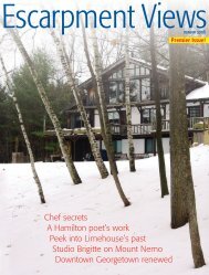
The seven-metre cascade of Hogg’s Falls.<br />
divert the water further north for<br />
a hydro-electric plant. Now,” he<br />
gestures, “well, you can see.”<br />
We watch as a young couple<br />
walk to the brink of the falls across<br />
bare limestone worn smooth by<br />
the passage of water, and peer over<br />
the brink into Cuckoo Valley beyond.<br />
Across the river, a ruined<br />
stone arch lies half hidden in the<br />
trees, the relic of an earlier attempt<br />
to harness the water’s power.<br />
Robert and I leave the falls,<br />
and begin our descent, skirting<br />
the gorge below the falls, threading<br />
the cedars. I hope to see one of<br />
the cuckoos for which this gorge<br />
is named, but no luck. The trail<br />
soon joins an old cart path, which<br />
winds its way through a mature<br />
hardwood forest. It is an easy descent.<br />
Eventually, the trail emerges<br />
onto the bare shoulder of the divide<br />
that separates the Beaver and<br />
Boyne rivers. We pause to catch<br />
our breath and take in the lovely<br />
view. The last stretch is relatively<br />
steep, through an old orchard,<br />
until the trail emerges onto the<br />
Lower Valley Road. Here, Robert<br />
has to leave me, for he has other<br />
responsibilities that day. I bid him<br />
farewell and carry on alone.<br />
A few metres south along the<br />
gravel road and the trail once more<br />
plunges into the forest. For the<br />
next hour I walk alone on a wellmarked<br />
trail. There is a moderate<br />
amount of climbing up and down,<br />
but the rewards are worth it. I pass<br />
through a remarkable variety of<br />
landscapes: mature woodlands full<br />
of bird song and deer, old pasture<br />
returning to forest, thickets of cedar<br />
and hemlock, some truly ancient<br />
ashes and maples, old logging<br />
trails, and hayfields dappled with<br />
daisies and buttercups. And, as I<br />
walk, I realize that I am never far<br />
from the sound of running water.<br />
One of the highlights is a place<br />
which my map has called the<br />
“Stone Ford.” It is well-named, for<br />
I have to cross a stream that has divided<br />
itself into three channels and<br />
the only bridge is a line of wobbly<br />
stepping stones. The middle channel<br />
is the deepest, and the stones<br />
are partially underwater. I very<br />
nearly take a dive, but recover and<br />
reach the far bank still dry shod.<br />
Finally, the trail emerges once<br />
more onto the Lower Valley Road.<br />
Across the road, the trail follows<br />
the Boyne River downstream to the<br />
parking lot at Hogg’s Falls. Suddenly,<br />
the trail seems crowded. I pass<br />
12 people in the next 100 metres,<br />
the first I have seen since Eugenia.<br />
I reach my car, but carry on a<br />
little further to see Hogg’s Falls.<br />
An old cart trail forms a crescent<br />
here, beginning and ending at the<br />
road. Once it carried timber to<br />
and from William Hogg’s sawmill.<br />
The mill has disappeared now,<br />
burned to the ground in 1888,<br />
but part of the old dam can still<br />
be seen. Then I stand above the<br />
falls. A veil of water plunges seven<br />
metres over a shelf of limestone to<br />
a lovely pool below. It is a fitting<br />
end to a perfect walk.<br />
My journey has taken me<br />
about two hours, and I can see<br />
why this trail is already one of the<br />
local favourites. I will certainly be<br />
back to hike this section of the<br />
trail again. n<br />
Ken Haigh, author of Under the Holy<br />
Lake, lives in the Beaver Valley.<br />
High<br />
Jinks<br />
& High<br />
Flying<br />
By Wallace S. Davis<br />
Editor’s note: Wallace Davis served<br />
as an air force officer in W.W.II.<br />
He was born in London, Ont.<br />
and moved to Georgetown in the<br />
late 1950s where he lived until his<br />
death in 2005. This is an excerpt<br />
from his memoirs.<br />
The chance of going to a university<br />
prior to the war was very limited.<br />
The cost to go to McGill was $60<br />
to $70 tuition and about $40 for<br />
books. I was fortunate enough to<br />
get an Ontario Scholarship which<br />
paid a hundred dollars at the time,<br />
which paid for my tuition fee and<br />
school books, but I had to find<br />
a job in Montreal for room and<br />
board, so I got a job at Eaton’s<br />
for $13.20 a week. While I was<br />
working there one of the Eaton<br />
Young Wallace Davis in uniform;<br />
Hawker Hurricane Mark XIII3,<br />
a figher-bomber flown in 1940<br />
during the Battle of Britain.<br />
Photo taken by Mike Davis at Canadian Warplane<br />
Heritage Museum in Mount Hope.<br />
Escarpment Views 10 ❧ <strong>Autumn</strong> <strong>2009</strong> ❧ <strong>Autumn</strong> <strong>2009</strong> 11 Escarpment Views