Pioneer: 2011 Vol.58 No.3

Create successful ePaper yourself
Turn your PDF publications into a flip-book with our unique Google optimized e-Paper software.
<strong>2011</strong> ■<br />
volume<br />
58 ■<br />
number<br />
3<br />
Salt Lake City, 1870<br />
Published by the Sons of Utah <strong>Pioneer</strong>s
<strong>2011</strong> volume 58 number 3<br />
■ ■<br />
pioneer<br />
Features<br />
Church History<br />
2 32<br />
Museum: The Salt Lake<br />
City Model, by Ron<br />
Andersen and Jim Raines 34<br />
Planning the City,<br />
6<br />
from Church History<br />
Museum<br />
36<br />
The Changing Face of<br />
12<br />
Salt Lake City,<br />
by Dale L. Morgan<br />
Eagle Gate<br />
17<br />
George Martin Ottinger<br />
18<br />
Independence Hall<br />
21<br />
22<br />
Dr. John M. Bernhisel<br />
1<br />
Orson Hyde<br />
25<br />
The Eagle Emporium<br />
25<br />
Godbe Exchange Building<br />
29<br />
31 Dale L. Morgan, Historian<br />
Paul Engelbrecht, by Ron<br />
Andersen<br />
Block 75: Daniel H. Wells;<br />
Jedediah M. Grant;<br />
Edward Hunter<br />
Block 93, 88<br />
38 Utah<br />
County:<br />
The 1850<br />
U.S. Census<br />
in the Utah<br />
Territory,<br />
by Michael Mower<br />
Departments<br />
President’s Message:<br />
by L. LaMar Adams<br />
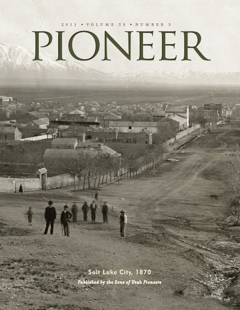
Cover: Early view<br />
of Salt Lake City,<br />
ca. 1870. Courtesy<br />
Church History<br />
Archives<br />
PRESIDENT: L. LaMar Adams<br />
PRESIDENT-ELECT:<br />
Richard O. Christiansen<br />
PUBLISHER: Kent V. Lott<br />
EDITOR-IN-CHIEF &<br />
MAGAZINE DESIGNER:<br />
Susan Lofgren<br />
EDITORIAL ADVISORY BOARD:<br />
Linda Hunter Adams<br />
Dr. F. Charles Graves<br />
Francis A. Madsen, Jr.<br />
WEBSITE:<br />
www.sonsofutahpioneers.org<br />
NATIONAL HEADQUARTERS:<br />
3301 East 2920 South<br />
Salt Lake City, Utah 84109<br />
(801) 484–4441<br />
E-mail: SUP1847@comcast.net<br />
SUBSCRIPTIONS: Call<br />
1-866-724-1847. For reprints<br />
and back issues, contact SUP.<br />
Published quarterly, $15.00 per year.<br />
MISSION STATEMENT:<br />
The mission of the National Society<br />
of the Sons of Utah <strong>Pioneer</strong>s is to<br />
preserve the memory and heritage of<br />
the early pioneers of the Utah Territory.<br />
We honor the pioneers for their faith<br />
in God, devotion to family, loyalty to<br />
church and country, hard work and<br />
service to others, courage in adversity,<br />
personal integrity, and unyielding<br />
determination. The society also honors<br />
present-day pioneers worldwide in<br />
many walks of life who exemplify<br />
these same qualities of character.<br />
It is further intended to teach these<br />
same qualities to the youth, who<br />
will be tomorrow’s pioneers.<br />
Contents<br />
Published by the Sons of<br />
Utah <strong>Pioneer</strong>s<br />
<strong>Pioneer</strong>ing yesterday, today, and tomorrow.<br />
© <strong>2011</strong>, trademark owned by the<br />
National Society of the Sons of Utah<br />
<strong>Pioneer</strong>s.<br />
www<br />
■<br />
sonsofutahpioneers<br />
■<br />
org
President’s Message<br />
by L. LaMar Adams<br />
“And it<br />
shall come<br />
to pass in<br />
the last<br />
days, that<br />
the mountain<br />
of<br />
the Lord’s<br />
house shall be established in the<br />
top of the mountains, and shall<br />
be exalted above the hills; and<br />
all nations shall flow unto it . . .<br />
for out of Zion shall go forth the<br />
law” (Isaiah 2:2–3).<br />
The Hebrew word, in this<br />
verse, for top (rosh) means head,<br />
chief, choicest, or best.<br />
Thus, Isaiah saw that the<br />
mountain where the Salt Lake<br />
Temple and Conference Center<br />
are situated was to be among<br />
the chiefest, or choicest, of the<br />
mountains for the gathering<br />
of the Saints in the last days.<br />
Although this depiction or<br />
imagery is also applicable to all<br />
mountains where there exists a<br />
temple in the Rocky Mountains<br />
from Canada to Mexico, the<br />
Salt Lake Valley stands as an<br />
ensign—the prototype.<br />
“Two days after the first<br />
company’s arrival, Brigham<br />
Young and several of the Twelve<br />
climbed a round bluff on the<br />
mountainside that President<br />
Young had seen in vision before<br />
leaving Nauvoo. They looked<br />
out over the valley’s vast expanse<br />
and prophesied that all nations<br />
of the world would be welcome<br />
in this place and that here the<br />
Saints would enjoy prosperity<br />
and peace. They named the hill<br />
Ensign Peak after the scripture in<br />
Isaiah that promised, ‘He shall<br />
set up an ensign for the nations,<br />
and shall assemble the outcasts<br />
of Israel’ (Isaiah 11:12).” (Our<br />
Heritage, chap. 7, p. 81.)<br />
In fulfillment of the prophecies<br />
of this ensign, the early<br />
pioneers came to Zion, the Salt<br />
Lake Valley, and there received<br />
their assignments as to where<br />
they were to go—some were<br />
to stay, as did my great grandparents,<br />
Barnabas L. Adams, the<br />
Powells, and the Chases; and<br />
others were sent out to settle<br />
towns from Idaho to California<br />
and Arizona, as did my great<br />
grandparents, the Kartchners,<br />
Savages, and Casteels. Still today<br />
Salt Lake City remains the symbol<br />
of the gathering place.<br />
The story is often told of<br />
Mary Murray Murdoch, lovingly<br />
called “Wee Granny,” at 4 feet<br />
7 inches tall, who was one of<br />
the members of Martin Handcart<br />
Company. She was not able<br />
to finish the journey to Zion to<br />
join her son, John. She died just<br />
before getting to Chimney Rock,<br />
Nebraska, and 10 days prior to<br />
age 74, in 1856. Her last words<br />
to her friends, the Steeles, was a<br />
request to tell her son John, that<br />
she died facing Zion.<br />
“Righteousness and truth<br />
will I cause to sweep the earth as<br />
with a flood, to gather out mine<br />
elect from the four quarters of the<br />
earth, unto a place which I shall<br />
prepare, an Holy City, that my<br />
people may gird up their loins,<br />
and be looking forth for the time<br />
of my coming; for there shall be<br />
my tabernacle, and it shall be<br />
called Zion” (Moses 7:62).<br />
Although this quote is in<br />
reference to the New Jerusalem,<br />
Salt Lake City serves the<br />
same roll in the interim. As I<br />
travel throughout the nation,<br />
and world, and people ask me<br />
where I am from, I tell them<br />
Salt Lake City (born in Murray,<br />
a suburb of SLC) because that<br />
usually connects for them and<br />
brings up discussions related to<br />
the ensign for which it stands.<br />
Thus, I have always thought<br />
it a privilege to be able to say<br />
that I am from Salt Lake City,<br />
even though I was raised in 4<br />
different states and 12 different<br />
towns by the time I graduated<br />
from high school. I also enjoy<br />
the connection with the past,<br />
those special feelings that come<br />
to me, when I pass by the home<br />
my father built in Sandy where<br />
we lived 77 years ago, or when<br />
walking past the temple and<br />
Temple Square. These experiences<br />
serve to turn my heart to<br />
my fathers, increase my desire<br />
to serve the God of our Fathers<br />
as greatly as they did.<br />
CORRECTION: In our last<br />
issue of <strong>Pioneer</strong> magazine <strong>2011</strong>,<br />
vol. 58, no. 2, on page 39, the<br />
marriage date for Margaret Jane<br />
Casteel and William Decatur Kartchner<br />
was given as Mar. 17, 1814.<br />
The correct year was 1844.<br />
<strong>Pioneer</strong> <strong>2011</strong> volume 58 number ■ ■<br />
3 1 www<br />
■<br />
sonsofutahpioneers<br />
■<br />
org
Church History Museum<br />
<br />
By Ron<br />
Andersen &<br />
Jim Raines<br />
The model of Salt<br />
Lake City is a center<br />
piece for A Covenant<br />
Restored exhibit<br />
in the Church History<br />
Museum in Salt Lake City.<br />
It captures the character<br />
of a city built upon the<br />
ideals of “the City of<br />
Zion.” In addition, it also<br />
reveals the stability, order, and permanence that<br />
were unusual in a settlement founded less than<br />
25 years earlier. Like several other cities in America<br />
(e.g., Washington, Philadelphia, and Cincinnati),<br />
the city was planned in advance of its construction.<br />
As the religious, geographic, and economic<br />
center of the Mountain West settlements, Salt Lake<br />
City holds a prominent and important place in the<br />
history of the Latter-day Saints.<br />
The year 1870 was chosen for the model<br />
because it was a pivotal year in the city’s history,<br />
while the city still reflected its pioneer character.<br />
Prior to this time Salt Lake City was considered<br />
a large “garden plot” village on the edge of the<br />
American frontier. With the coming of the railroad<br />
in 1869 its character would change forever.<br />
Each block of the model, to the middle of<br />
its contiguous streets, was laid out on paper and<br />
glued to foam-core boards for stiffness. Based on<br />
the “Birdseye View” map of Salt Lake City, 1870,<br />
Sanborn maps, and photographs, the footprints<br />
of homes, outbuildings, orchards, gardens,<br />
fences, ditches, vehicle and pedestrian paths<br />
were drawn in.<br />
A shelf-system was created<br />
with a labeled slot for each of<br />
the 64 blocks that would make<br />
up the model. Keeping all<br />
things pertaining to a particular<br />
block together meant Museum<br />
staff and missionaries could<br />
work on any block or blocks in<br />
any order until it was time to<br />
transfer items to the big model.<br />
The model’s landscape was<br />
created in four sections by<br />
James Keilor, an outside contractor,<br />
using foam layers for each contour level.<br />
Each section would contain 16 city blocks. Part<br />
way into the project, Keilor became ill, at which<br />
time the Museum staff took over the work of<br />
completing the project. The landscape elevation<br />
was exaggerated somewhat for viewing purposes,<br />
standard for exhibit models. Clay was used to fill<br />
in and shape the landscape between the contour<br />
lines. Block parameters were then marked off<br />
with a pounce wheel.<br />
Dean Soderquist then coated the clay model<br />
with fiberglass to make a mold (negative image)<br />
of the model. Fiberglass was then used again, this<br />
time to make the positive landscape image. Using<br />
enlarged maps and photographs, Jim Raines,<br />
an experienced model builder, constructed the<br />
buildings out of clear acrylic sheets. Roofs were<br />
made from styrene sheets (a plastic material used<br />
in model building). The buildings were painted<br />
with Floquil paint, which is used in the construction<br />
of model railroads.<br />
Window and door designs were created by<br />
an artist, then reduced to the proper scale, and<br />
finally sent to a company that made stamps out<br />
<strong>Pioneer</strong> <strong>2011</strong> volume 58 number ■ ■<br />
3 2<br />
www<br />
■<br />
sonsofutahpioneers<br />
■<br />
org
of the images on the end of dowels. A jig held<br />
the buildings steady and horizontal, while<br />
missionaries inked in the windows and doors.<br />
Various colors were used with the shingle stamps.<br />
Different fence types were drawn by an artist<br />
and sent to a company that reduced the images<br />
to proper scale and then etched the images on<br />
shim stock (thin brass sheets). The shim stock was<br />
Tina Soderquist (above) shaping clay; Gale Hammond (below)<br />
painting objects while lying on scaffold.<br />
<strong>Pioneer</strong> <strong>2011</strong> volume 58 number ■ ■<br />
3 3<br />
www<br />
■<br />
sonsofutahpioneers<br />
■<br />
org
then sprayed with the proper color and cut to the<br />
proper length.<br />
BYU students were paid to create thousands<br />
of trees. They began with thin, multistrand copper<br />
wire that had the insulation stripped off. The<br />
bottom half of each tree was twisted and dipped<br />
in brown gesso paint, which became the trunk.<br />
The rest of the wires were spread out and dipped<br />
in glue. Green foam particles were sprinkled over<br />
these wires creating the tree’s foliage. Missionaries<br />
transferred the buildings, fences, and trees onto<br />
the model, starting with the four middle blocks of<br />
each quadrant, then the other contiguous<br />
12 blocks surrounding the middle.<br />
The completed quadrants were placed<br />
on a frame of wooden and two aluminum<br />
trusses and were joined together, hiding the<br />
seams. A 20-foot aluminum scaffold was<br />
built that would straddle the 10 x 10 foot<br />
model and that would allow access to any<br />
location on the model.<br />
Finishing touches were added by Gale<br />
Hammond,who created the ruts in the<br />
street and the lumber piles; scattered the<br />
leaves, and did any touchup painting.<br />
The model took three years to complete<br />
and was raised into its pyramid home in<br />
1990, using a system of plywood sheets and<br />
a large inflatable inner tube.<br />
Ron Andersen, church service missionary<br />
at the Church History Museum, has<br />
done a great deal of work in identifying and<br />
organizing owners and occupants of plots<br />
on the city blocks, along with collecting<br />
biographical data. Much of the information<br />
for this issue of <strong>Pioneer</strong> was provided by Ron<br />
Andersen. Welden Andersen, a photographer<br />
for the Church, and a brother to Ron,<br />
did the high definition photography of the<br />
model. Randall Dixon was the consultant<br />
on building sizes, shapes, and locations as<br />
the model was constructed and also identified<br />
buildings in the actual photographs.<br />
Dean Soderquist working on model construction.<br />
Information concerning the Salt Lake City Model is<br />
used in this issue of the <strong>Pioneer</strong> with approval from<br />
the Church History Department. Historical photos<br />
courtesy Church History Library unless otherwise<br />
noted.<br />
<strong>Pioneer</strong> <strong>2011</strong> volume 58 number ■ ■<br />
3 4<br />
www<br />
■<br />
sonsofutahpioneers<br />
■<br />
org
<strong>Pioneer</strong> <strong>2011</strong> volume 58 number ■ ■<br />
3 5<br />
www<br />
■<br />
sonsofutahpioneers<br />
■<br />
org
Planning the City<br />
<strong>Pioneer</strong> <strong>2011</strong> volume 58 number ■ ■<br />
3 ■ 6 www<br />
sonsofutahpioneers<br />
■<br />
org
from Church History Museum<br />
City plat above<br />
courtesy Harold B.<br />
Lee Library, Brigham<br />
Young University.<br />
The sense of order<br />
and uniformity, which<br />
is still evident in<br />
1870, was a result<br />
of the extensive and<br />
detailed city planning<br />
guidelines that the<br />
Saints sustained and<br />
accepted for their<br />
community.<br />
In harmony with the principles and ideals of<br />
Joseph Smith’s vision of the “City of Zion,” the<br />
city was platted in a square grid oriented to<br />
the cardinal compass directions with the Temple<br />
Block at its very heart. It was to be a city of uniform<br />
garden lots, with all farming taking place in<br />
the “Big Field” south of present-day Ninth South.<br />
The first plat (Plat A) of the city was laid out in<br />
August 1847 by Orson Pratt and Henry Sherwood.<br />
The initial survey included 135 blocks often acres<br />
each subdivided into eight lots of 1.114 acres. The<br />
lots were numbered one to eight beginning with<br />
the lot on the southeast corner. The streets were<br />
132 feet wide from curb to curb. In addition to<br />
Temple Square, three other blocks were designated<br />
as public land, including the block upon which<br />
the fort was built. South Temple and East Temple<br />
(Main Street) were the east–west and north–south<br />
streets from which other streets were oriented.<br />
Thus, the first east–west street south of South<br />
Temple was First South and the next was Second<br />
South. The same pattern was repeated to the east.<br />
A problem was created by West Temple and North<br />
Temple. They were not considered First West or<br />
First North respectively, as they would have been<br />
if the pattern of numbering streets from the corner<br />
of East and South Temple had been strictly applied.<br />
Instead, these streets held their own designations,<br />
of North Temple and West Temple. First<br />
North and First West were assigned to the first<br />
streets farther north and west, respectively. When<br />
residences or business locations were assigned<br />
street numbers in December 1883, the numbers<br />
were oriented from the geodetic survey marker<br />
placed at the southeast corner of Temple Square by<br />
Orson Pratt.<br />
For more than one hundred years, this system<br />
caused confusion on the north and west portions of<br />
the Salt Lake City grid system of streets. The problem<br />
was solved in 1971/72 when West Temple was<br />
also designated First West and North Temple as First<br />
Left artwork located at Sons of Utah <strong>Pioneer</strong>s headquarters.<br />
<strong>Pioneer</strong> <strong>2011</strong> ■<br />
volume 58 ■<br />
number 3 7<br />
www<br />
■<br />
sonsofutahpioneers<br />
■<br />
org
North. All of the remaining streets on the north<br />
and west were then renumbered appropriately.<br />
For example, First West and First North became<br />
Second West and Second North, respectively.<br />
Before the Brigham Young Company left to<br />
return to Winter Quarters, Church leaders were<br />
allowed to choose lots for their families. Most<br />
selected city plots near the Temple block. The rest<br />
of the lots were distributed the following summer.<br />
There were so many new immigrants, however,<br />
that an additional Plat B, of 63 blocks, had to be<br />
laid out, and a third section Plat C, of 84 blocks,<br />
was added in 1849.<br />
Although it is commonly believed that lots<br />
were distributed by lottery, it is apparent, because<br />
of the large number of family members and friends<br />
who received property in the same area, that<br />
they were probably distribued either by choice<br />
or assignment. After 1849, lots were assigned by<br />
bishops who presided over the wards in which<br />
vacant lots were located. Land was distributed only<br />
to adults with families. The first settlers received<br />
these lots as a spiritual stewardship or inheritance,<br />
according to Brigham Young, “for the Lord has<br />
given it to us without price.” New landowners<br />
were required only to pay the filing fee of $1.50.<br />
Since the Great Basin was part of Mexico until<br />
1848, known to that nation as Upper California,<br />
no American land laws applied until Utah became<br />
a territory with the Compromise of 1850. There<br />
would be no legal landholding recognized by the<br />
federal government in Salt Lake until the establishment<br />
of the town charter of 1872. Up to that time,<br />
only local deeds applied. During the time of the<br />
model, Salt Lake City was occupied by “squatters”<br />
in the eyes of the federal government.<br />
The city grew naturally to the south and east,<br />
where it was unfettered by natural barriers such<br />
as the Jordan River on the west and the sulphur<br />
springs and hills on the north. The next official<br />
addition to the city was made about 1854 with the<br />
survey of Plat D, called the North Bench or Dry<br />
Bench, later called “the Avenues.” This new section<br />
of the city was the first to deviate from the<br />
10-acre-block plan. Probably because of the steep<br />
slopes and a lack of water, this section was laid out<br />
in 2 1/4 acre blocks with four lots each. The seven<br />
streets which ran east and west were named Fruit<br />
(1st Ave.), Garden (2nd Ave.), Bluff (3rd Ave.), Wall<br />
(4th Ave.), Prospect (5th Ave.), High (6th Ave.), and<br />
Mountain (7th Ave.). The streets running north<br />
and south were all named for trees, such as, Walnut,<br />
Chestnut, Pine, Birch, etc. Only the farthest west,<br />
north and south street, Walnut, is shown on the<br />
model. Of the streets running east and west, Fruit,<br />
Garden, Bluff, Wall, and Prospect are on the model.<br />
It was not until 1883 that the North Bench was<br />
renamed with its distinctive numbered and lettered<br />
street names. (Numbered streets were changed to<br />
Avenues in 1907.) During the era of the model,<br />
<strong>Pioneer</strong> <strong>2011</strong> volume 58 number ■ ■<br />
3 8<br />
www<br />
■<br />
sonsofutahpioneers<br />
■<br />
org
the North Bench was a popular residential area for<br />
tradesmen, businessmen, and professionals who<br />
wanted to live close to the center of town, but<br />
who did not want large garden lots. To the west<br />
and southwest of Arsenal (Capitol) Hill was the<br />
Marmalade District. It was so called because<br />
the streets were named after fruit trees.<br />
By 1870 many of the city lots had been broken<br />
up and sold in parcels to accommodate more<br />
homes. This was especially true of the business<br />
district, where it was more efficient and lucrative<br />
to build stores and offices immediately next door<br />
to each other. Notice, however, that none of the<br />
blocks have yet been subdivided by an additional<br />
street. Commercial Street was the first in 1871.<br />
The sense of order and uniformity, which is still<br />
evident in 1870, was a result of the extensive and<br />
detailed city planning guidelines that the Saints sustained<br />
and accepted for their community. The first<br />
of these guidelines was accepted in August 1847<br />
and included the following: Only one house would<br />
be built on each lot. Each house was to be built 20<br />
feet back from the street on the center line of the<br />
property for uniformity. This practice was initially<br />
also followed by businesses. As businesses replaced<br />
residences along Main Street the buildings were<br />
Main & Center from 200 N., late 1880s; house on left<br />
preceded McCune mansion.<br />
<strong>Pioneer</strong> <strong>2011</strong> ■<br />
volume 58 ■<br />
number<br />
3 9<br />
www<br />
■<br />
sonsofutahpioneers<br />
■<br />
org
uilt to the edge of the sidewalk rather than 20 feet<br />
back as originally required. Compare the Council<br />
House and Globe Bakery with the other buildings<br />
along the west side of Main Street between South<br />
Temple and First South streets. The lots on alternate<br />
blocks would face north and south or east and<br />
west; thus there would be no houses facing each<br />
other on the opposite sides of the street. Instead,<br />
residents could enjoy the views of gardens and<br />
orchards across the street. Houses on the same side<br />
of the street would be 132 feet apart, and each<br />
would have a garden reaching from the rear of the<br />
house to the center of the block, approximately<br />
300 feet. Later ordinances dictated that each lot be<br />
fenced to keep stray livestock out and that livestock<br />
be penned at the rear of the<br />
property. Territorial laws and<br />
city ordinances were constantly<br />
bolstered by the rhetoric<br />
of Church leaders, such as<br />
the charge from Brigham<br />
Young for every man to<br />
“cultivate his own lot<br />
and set out every kind<br />
of fruit and shade tree<br />
and beautify the city.”<br />
In comparing<br />
the initial layout of<br />
Great Salt Lake City<br />
(GSLC) with the<br />
“My people shall become<br />
a numerous<br />
and mighty host in the<br />
vastness of the Rocky<br />
Mountains.”<br />
— Joseph Smith<br />
“We have come here<br />
according to the direction<br />
and counsel of Brother<br />
Joseph, before his<br />
death.”<br />
— Brigham Young,<br />
Salt Lake City,<br />
July 28, 1847<br />
<strong>Pioneer</strong> <strong>2011</strong> ■<br />
volume 58 number 3 <br />
■<br />
3 10<br />
www<br />
■<br />
City of Zion as envisioned by the Prophet<br />
Joseph Smith (pictured right), several similarities<br />
are evident, similarities that show that<br />
Brigham and other Church leaders attempted<br />
to pattern the city, to the extent possible, after<br />
the Prophet Joseph’s concept. Brigham apparently<br />
carried with him the plat of the City of<br />
Zion as he entered the Great Salt Lake Valley.<br />
Hence, he was consciously attempting to carry<br />
out Joseph’s colonization plans. In the City of<br />
Zion plat, three 15-acre blocks are located in<br />
the center of an approximately one-mile-square<br />
plat of city blocks. Two of the blocks contain<br />
12 temples each, one set each for the Aaronic<br />
and Melchizedek priesthoods. The other block<br />
was for the bishops storehouses. The GSLC<br />
plan has one 10-acre Temple Block with<br />
city blocks radiating out in every direction<br />
except where limited by the mountains to<br />
the north and northeast. As mentioned<br />
previously, the temple<br />
location was directed by<br />
a vision given to Brigham<br />
Young. . . .<br />
Serious farming efforts were<br />
located outside of the city with<br />
farm plot size determined by the need<br />
of the family. In the case of GSLC,<br />
these farm plots were located in the<br />
“Big Field” south of Ninth South. This<br />
area was a large farming plat surrounded by<br />
a common fence. Plot size ranged from 5<br />
to 80 acres. Five-acre plots were assigned to<br />
craftsmen, such as shoemakers, who could<br />
farm only a small area and these plots were<br />
located closest to the city. Others, divided<br />
into 10, 20, 40, or 80 acres, were farmed by<br />
those who made their living primarily as<br />
farmers.<br />
Thus, the harmony of the GSLC with<br />
the City of Zion is apparent. Deviations<br />
from the City of Zion in the GSLC plan<br />
were necessary because of the limitations<br />
caused by the mountains on expansion<br />
equally in all directions and because of<br />
the practical needs of the people.<br />
sonsofutahpioneers<br />
Eyes Westward, sculpture by Dee Jay Bawden<br />
■<br />
org
We propose to have the temple lot<br />
contain 40 acres, to include the<br />
ground we are now on—what do you say to<br />
that? All right? That the streets be 88 feet<br />
wide, sidewalks 20 feet, the lots to contain<br />
1 1/4 acres, eight lots in a block, the houses<br />
invariably set in the center of the lot, 20<br />
feet back from the street. Neither will they<br />
be filled with cattle, horses and hogs, nor<br />
children, for they will have yards and places<br />
appropriated for recreation, and we will<br />
have a city clean and in order.”<br />
—Brigham Young, 1847<br />
<strong>Pioneer</strong> <strong>2011</strong> volume 58 number ■ ■<br />
3 ■<br />
11 www<br />
sonsofutahpioneers<br />
■<br />
org
The<br />
Changing Face<br />
of Salt Lake City<br />
By Dale L. Morgan, Historian<br />
Salt Lake Valley is one of the handsomest on<br />
all the broad face of America. It is one of a<br />
fertile chain of valleys running along the<br />
western base of the Wasatch Mountains. . . . From<br />
the time the Mormons entered it in 1847, seeking<br />
a mountain refuge to which the Saints might<br />
gather from all over the world, it has had an identity<br />
all its own, “The Valley.”<br />
The city founded by the Mormon pioneers,<br />
known initially as Great Salt Lake City, but legally<br />
since 1868 by its present name, has changed continually<br />
since 1847 while its central identity has<br />
remained constant. . . .<br />
So green and tree-grown is its aspect today<br />
that it is hard to visualize Salt Lake Valley in 1847<br />
as a nearly treeless expanse. There were a few<br />
cottonwoods along the courses of the creeks, with<br />
here and there a struggling scrub oak or juniper,<br />
but Willard Richards was not exaggerating much<br />
when he reported to Brigham Young, “Timber can<br />
hardly be said to be scarce in this region for there<br />
is scarcely enough of it to be named and sage is as<br />
scarce as timber.” . . .<br />
On the afternoon of July 28 Brigham Young<br />
designated the site for the Temple Block, between<br />
the forks of City Creek, and there, after nightfall,<br />
he convened the whole camp. “It was,” Norton<br />
Jacob wrote, setting down in his journal a delightful<br />
impression of the evening, “a beautiful and<br />
The Great Salt Lake from the Foot of Ensign Peak by George Martin Ottinger, Springville Museum of Art.<br />
<strong>Pioneer</strong> <strong>2011</strong> volume 58 number ■ ■<br />
■<br />
3 12 www<br />
sonsofutahpioneers<br />
■<br />
org
instructive] scene—the soft mild air that always<br />
prevails here at night so that the men sit down<br />
comfortably in their shirt sleeves; the full moon<br />
shone over the eastern mountain shedding her<br />
mild radiance on the quiet valley of the Utah outlet<br />
[the Jordan River]; whilst we were seated on the<br />
ground engaged in council.”. . .<br />
There was nothing haphazard about the origins<br />
of Salt Lake City. If ever there was a planned<br />
community, it was this one. The plat itself was<br />
patterned after one originated in 1833 by Joseph<br />
Smith, the Mormon Prophet. Smith had adopted<br />
as his own the type of checkerboard grid familiar<br />
to America since William Penn laid out Philadelphia.<br />
Particularly well adapted to use in the prairie<br />
states, where the gently rolling land imposed no<br />
harsh logic of its own, the plat for the City of Zion<br />
was also suited to use in the Valley. Streets, as provided<br />
by this plat, were eight rods (132 feet) wide,<br />
made to run with the cardinal directions and to<br />
cross at right angles, while the square blocks into<br />
which the land was divided were 10 acres each, exclusive<br />
of the streets. In theory, the Temple Block<br />
was the center of the city, but it could remain only<br />
the center of Plat A, for it was located so close under<br />
the rising land at the north end of the Valley<br />
as to make inevitable an asymmetrical city.<br />
The first thought, that the Temple Block<br />
should consist of 40 acres, or four full blocks, was<br />
reconsidered when it was realized how large a<br />
tract was 40 acres and the impossibility of doing<br />
it justice; accordingly, the Temple Square was<br />
reduced to 10 acres. The southeast corner of<br />
this reduced Temple Block was fixed as the<br />
zero point for beginning the survey of<br />
the city. (It was also used for subsequent U.S.<br />
Land Office surveys, becoming the Salt Lake<br />
Prime Meridian.) Street numbering then<br />
proceeded with great simplicity, outward<br />
from North Temple, West Temple,<br />
South Temple, and East Temple streets,<br />
the next cordon of streets being<br />
named First North, First West,<br />
First South, First East, and so on<br />
out. This nomenclature has<br />
endured, except that in<br />
<strong>Pioneer</strong> <strong>2011</strong> volume 58 number ■ ■<br />
3 13 www ■<br />
sonsofutahpioneers<br />
■<br />
org
Brigham Young was early<br />
granted legal control of City<br />
Creek Canyon. . . . Access to it<br />
for logging or other purposes<br />
was to be had only with his<br />
permission, and through his<br />
property—therefore, after 1859,<br />
by proceeding under the Eagle<br />
. . . it made Young’s property a<br />
semipublic thoroughfare, so he<br />
had the road through his property<br />
walled in on both sides.<br />
Lion & Beehive House<br />
Brigham Young<br />
Schoolhouse<br />
<br />
Historian’s Office<br />
George A. Smith<br />
<strong>Pioneer</strong> <strong>2011</strong> ■<br />
volume 58 number ■<br />
3 ■<br />
14 www<br />
sonsofutahpioneers<br />
■<br />
org
the course of time East Temple was renamed Main<br />
Street, and First East became State Street. . . .<br />
Not until Brigham Young returned with the<br />
Mormon immigration of 1848 did occupation of<br />
the city plat begin; through the spring and summer<br />
the settlers carried out their farming operations<br />
from their homes in the fort.<br />
Some of the apostles had been allowed, in<br />
the summer of 1847, to select their own “inheritances,”<br />
mostly property fronting on the Temple<br />
Block, and at that time Young had picked out for<br />
himself and family the block immediately east of<br />
the Temple Square. . . . To treat land<br />
indefinitely as “inheritances” was not<br />
practical in terms of the American<br />
political and economic system; the<br />
settlers upon it could have no valid<br />
titles until the Indian title had been<br />
extinguished, formal surveys made,<br />
and the land placed upon the market<br />
by the U.S. government. These<br />
things did not come to pass for several<br />
decades, and meanwhile squatter titles<br />
developed in Utah as elsewhere.<br />
Presently Main Street began to take<br />
shape, with stores built on corners<br />
or anywhere else, on small and large<br />
plots of land, and not 20 feet back<br />
from the sidewalk. Still the 10 acre<br />
blocks remained as the basic structure<br />
of the city, and until the pressure of<br />
population forced the expansion of Salt<br />
Lake into fringe areas—first, in the late<br />
sixties and seventies, up on the sloping<br />
north benches that were carved<br />
into the small squares familiarly called<br />
the “Avenues,” and later out beyond<br />
Ninth South Street, where blocks were<br />
laid out as oblongs—this pattern did<br />
not change.<br />
First Public Building<br />
Laying out streets as straight lines<br />
crossing at right angles persisted<br />
within the memory of the living generation,<br />
and curving streets are almost<br />
solely to be found in recent subdivisions—east<br />
of Fifteenth East Street,<br />
After the lots were given out to the people,<br />
a united effort was made to fence the city.<br />
Instead of fencing each lot separately, each<br />
ward [an area of nine blocks] was fenced in<br />
one field, and each owner of a lot in a ward<br />
built his proportion of the fence. This made<br />
the work of fencing the lots comparatively<br />
easy, and it answered every purpose for several<br />
seasons. The streets were all kept open, but<br />
not at their present width. The owners of lots<br />
cultivated the streets in front of their premises,<br />
leaving no more than a sufficient space for<br />
travel. At the end of each street leading out of<br />
the ward into the main thoroughfares which<br />
ran around each ward, there were bars, which<br />
everyone who passed in or out with a team<br />
or on horseback was required to be careful in<br />
putting up. There was no monopoly of land<br />
allowed. No man was permitted to take up a<br />
city lot or farming land for purposes of speculation.<br />
Farming land was divided and given out<br />
in small parcels, so that all could have a proper<br />
proportion. . . . The enforcement of this rule<br />
made the settlement of the city and the farming<br />
lands very compact, and created a community<br />
of interest which would not have been felt<br />
under other circumstances. . . .<br />
“Next the city was surveyed into five acre<br />
lots. This was for the purpose of accommodating<br />
the mechanics and others who would<br />
reside in the city. Next to the five acre lots the<br />
ten acre lots were laid out; then the twenty<br />
acres followed by the forty and eighty acre lots,<br />
upon which farmers could build and reside.<br />
All these were, for safety and present convenience,<br />
enclosed in one common fence, each<br />
owner of land building in proportion to the<br />
amount he had in his field, and the fence to<br />
be erected in such a manner as to be satisfactory<br />
to men appointed to inspect and accept<br />
of it when completed. [In a letter of October 9,<br />
1848, Brigham Young estimated that the fence<br />
would be ‘17 miles and 53 rods long, eight<br />
feet high.’]<br />
—George Q. Cannon<br />
<strong>Pioneer</strong> <strong>2011</strong> ■<br />
volume 58 ■<br />
number<br />
3 15<br />
www<br />
■<br />
sonsofutahpioneers<br />
■<br />
org
west of Eighth West Street, and north of the State<br />
Capitol. . . .<br />
The first new public building undertaken<br />
was the Council House. As early as September 30,<br />
1848, Brigham Young proposed the building of<br />
such a structure by tithing labor (men who could<br />
not pay the monetary tithe to the church might<br />
work it out), and on October 29 he put the authority<br />
of the church behind the proposal. Although<br />
active work did not begin until February, 1849,<br />
the building was completed in December, 1850.<br />
Upon foundation and first story walls constructed<br />
of red sandstone, it had a second story of adobe,<br />
surmounted by a cupola, which makes it instantly<br />
recognizable in any early view of Salt Lake City.<br />
T<br />
he plan for the town followed the basic principles,<br />
although not the details, of the City<br />
of Zion concept developed by Joseph Smith and<br />
others in 1833. This plan called for each community<br />
to be laid out in a square grid pattern,<br />
with ample land for each family to have its own<br />
home, orchard, and garden. Zoning regulations<br />
required that factories and farms be beyond the<br />
town boundaries. Wide streets with homes sitting<br />
back from them gave a feeling of spaciousness<br />
and planning, while the public squares provided<br />
room for churches, schools, and other community<br />
buildings. In actual practice, most early Utahans<br />
found it more convenient to have their barns and<br />
domestic animals near their homes than outside<br />
the city limits.<br />
The plan had been experimented with in<br />
Ohio, Missouri, and Illinois, and it proved to be<br />
particularly well adapted to the arid Great Basin.<br />
Limited water resources mandated settling in<br />
small communities near mountain streams flowing<br />
from the canyons. These villages were more<br />
easily protected against Indian attack than were<br />
individual farmsteads, and they also provided<br />
an enriched social, cultural, and religious<br />
atmosphere.”<br />
— Richard D. Poll, Utah’s History (Provo, UT.:<br />
BYU Press, 1978), 135–36.<br />
The Council House was situated at the southwest<br />
corner of South Temple and Main streets, and until<br />
its destruction by fire on June 21,1883 (a calamity<br />
made a historical catastrophe in that the collection<br />
of the great pioneer photographer, Charles R. Savage,<br />
went simultaneously up in smoke), it served<br />
every public purpose; church services, sessions of<br />
the legislature, and all kinds of public meetings<br />
were held in it; at one time it housed the Territorial<br />
Library and the Deseret News; and from 1869<br />
to 1881 it was the home of the Deseret University<br />
(the future University of Utah). The disappearance<br />
of this landmark is one of the first-generation cultural<br />
tragedies of Salt Lake City. . . .<br />
The 1850s<br />
The “down-town” city . . . began to emerge<br />
on Temple Block and the “Brigham Young” block<br />
to the east, during the 1850’s. Here alone old-city<br />
and modern city find a common identity. On the<br />
Temple Block, the surrounding wall is older than<br />
any of the now famous buildings that rise within,<br />
C. R. Savage Art Gallery left<br />
of Council House. Assembly<br />
Hall and Tabernacle seen in<br />
background, ca. 1880.<br />
<strong>Pioneer</strong> <strong>2011</strong> volume 58 number ■ ■<br />
3 16<br />
www<br />
■<br />
sonsofutahpioneers<br />
■<br />
org
Eagle Gate, which<br />
is at State Street and South Temple,<br />
has changed many times during its<br />
146 [now 152] years of existence.<br />
As the entrance to Brigham<br />
Young’s estate at the mouth of City<br />
Creek Canyon, it is located near<br />
where the pioneers homesteaded<br />
that first summer in 1847.<br />
Consistent with his New<br />
England heritage, President Young<br />
fenced and gated the land for<br />
privacy and also for protection from<br />
City Creek flooding. It was designed<br />
by architect Truman O. Angell and<br />
Hiram B. Clawson.<br />
The original eagle was carved<br />
by Ralph Ramsey and William<br />
Spring from five laminated wooden<br />
blocks and used an actual eagle<br />
that had been found in City Creek<br />
Canyon as its model. The monument<br />
weighed 500 pounds, had<br />
16-foot-wide outstretched wings<br />
and rested upon curved wooden<br />
arches that used 9-foot-high<br />
cobblestone bases as their anchor.<br />
The eagle sat on a beehive and a<br />
star mount.<br />
Large wooden gates closed<br />
the 22-foot-wide opening of the<br />
original Eagle Gate at night. Young<br />
had the Beehive House, Lion<br />
House, private offices, a<br />
flower garden, school, barns,<br />
sheds, greeneries, orchards<br />
and vegetable gardens in<br />
his yard. For many years, the gate<br />
not only marked the entrance to<br />
Young’s property but also to City<br />
Creek Canyon, as the highway was<br />
then the canyon toll road, not State<br />
Street.<br />
Fourteen years after Young’s<br />
death in 1891, the gates were removed<br />
and the street was widened<br />
to two lanes. Soon after, electric<br />
streetcars began traveling the area<br />
and a greater height was needed to<br />
accommodate the overhead wires.<br />
The eagle was then sent back East<br />
to be covered with a layer of copper,<br />
and new supports resting on<br />
stone pillars were added. The gate<br />
was also widened in a new design<br />
by architect J. Don Carlos Young.<br />
It was remodeled another three<br />
times during the next 60<br />
years and eventually became<br />
just wide enough for<br />
four lanes of traffic, but<br />
there was no extra room.<br />
17 <br />
On April 18, 1960, a truck<br />
severely damaged Eagle Gate. The<br />
eagle and beehive were removed<br />
later that day. The Church of Jesus<br />
Christ of Latter-day Saints, which<br />
owned them, eventually gave the<br />
eagle and beehive to the Daughters<br />
of Utah <strong>Pioneer</strong>s because the<br />
wooden portions had deteriorated<br />
and could not be remounted again.<br />
They are in the DUP museum<br />
today at 300 N. Main.<br />
In succeeding weeks all the<br />
gate structure was removed. A time<br />
capsule dating to 1891 was found<br />
in one of the bases of the old support<br />
columns. For more than three<br />
years, there was no Eagle Gate at<br />
State Street and South Temple.<br />
Architect George Cannon Young,<br />
a descendant of Brigham<br />
Young, began to design a new<br />
frame to support a new Eagle Gate.<br />
Artist Grant R. Fairbanks made<br />
a replica of the original bird out<br />
of bronze, though this one was<br />
larger, with a 20-foot wingspan and<br />
10-foot-long body, and weighed<br />
about 4,000 pounds. The stone<br />
fence near the Lion House was<br />
moved 20 feet west to make room<br />
for a larger five-lane span.<br />
—Deseret News, Friday, Nov. 24,<br />
2006
George Martin Ottinger<br />
was born in<br />
Springfield<br />
Township,<br />
Montgomery<br />
County,<br />
Pennsylvania,<br />
on<br />
February 8,<br />
1833 . . .<br />
[to] William and Elizabeth Martin<br />
Ottinger, who were Quakers.<br />
. . . Ottinger converted to Mormonism<br />
in Pennsylvania in June 1858 at<br />
the behest of his mother, a church<br />
member. . . .<br />
By the summer of 1861, Ottinger<br />
had moved his mother to<br />
Salt Lake City, Utah Territory. His<br />
original intention was to settle her<br />
there, then move on to California.<br />
However, when he found there was<br />
plenty of work for him in Salt Lake<br />
City, he decided to remain there.<br />
Ottinger soon entered into partnership<br />
with Charles Roscoe Savage, a<br />
local photographer. There is some<br />
evidence that Savage had been<br />
acquainted with Ottinger’s mother<br />
back east and that perhaps Savage<br />
and Ottinger had actually known<br />
each other before Ottinger came<br />
to Salt Lake City. As Ottinger later<br />
related, “I commenced coloring<br />
photographs, very poor ones at<br />
that, taken by C. R. Savage.” He<br />
received two and a half gallons of<br />
molasses as payment for his first<br />
coloring assignment. . . . During his<br />
first year in Salt Lake City, Ottinger<br />
married Mary Jan McAllister Cullin.<br />
They had a son, William before<br />
the untimely death of Mary Jane.<br />
Ottinger remarried on December 3,<br />
1864, to Miss Phoebe Nelsen.<br />
As the . . . partnership developed,<br />
Ottinger became identified<br />
as the expert retoucher and studio<br />
worker, while Savage grew increasingly<br />
interested in field photography.<br />
. . . [Ottinger] had begun<br />
to display a flair for large-scale<br />
painting by 1862, when he painted<br />
the stage scenery for the Salt Lake<br />
Theater. Later, Ottinger developed<br />
a talent as an actor, and he took on<br />
several lead roles in Shakespearean<br />
dramas.<br />
On July 25, 1863, the directors<br />
of the newly founded Deseret Academy<br />
of Arts prepared a prospectus<br />
in which George M. Ottinger was<br />
listed as president and drawing<br />
instructor and Charles R. Savage a<br />
member of the board of directors.<br />
The curriculum was to include all<br />
the disciplines of the fine arts, as<br />
well as photography. Students interested<br />
in enrolling in the academy<br />
were directed to do so at the Savage<br />
and Ottinger gallery. On December<br />
18, 1863, the partners advertised<br />
the opening of their “New Gallery”<br />
between the post office and Council<br />
House in Salt Lake City. In addition<br />
to “first class Portraiture in any<br />
style,” they offered “views of City,<br />
Mountain and Lake Scenery, for<br />
sale.” The following year Ottinger<br />
moved his family into a house at<br />
384 Third Street, where he would<br />
reside for most of the remainder of<br />
his life. . . .<br />
Ottinger and Savage dissolved<br />
their partnership around 1872 but<br />
remained close friends for the rest<br />
of their lives. . . . Ottinger . . . was<br />
assistant engineer of the Salt Lake<br />
City Volunteer Fire Department from<br />
1872 until being elected fire chief<br />
in 1876 . . .[and] superintendent of<br />
the city’s waterworks beginning in<br />
1870. . . . He and Charles Savage<br />
traveled together to England on a<br />
church mission in 1879, and he<br />
painted murals for Mormon temples<br />
in St. George in 1877, Logan in<br />
1884, and Manti in 1888.<br />
In 1881, Ottinger was a<br />
cofounder of the Salt Lake Art<br />
Association . . . , [was a] “special<br />
instructor” in art at the University of<br />
Deseret on August 21, 1882, and<br />
was instrumental<br />
in training many<br />
of early Utah’s<br />
best artists. By<br />
1885 he was a<br />
full professor. . . .<br />
Ottinger was appointed<br />
adjutant<br />
general of Utah<br />
in March 1894.<br />
. . . [and] he organized<br />
the Utah<br />
National Guard.<br />
. . . Ottinger<br />
died October 29,<br />
1917, . . . [and is]<br />
buried in the City<br />
Cemetery, Salt<br />
Lake City.<br />
Excerpts from<br />
Peter E. Palmquist,<br />
Thomas R.<br />
Kailbourn, <strong>Pioneer</strong><br />
Photographers of<br />
the Far West: A<br />
Biographical<br />
Dictionary, 1840–<br />
1865 (Stanford,<br />
CA.: Stanford<br />
Univ. Press, 2000),<br />
426–27.<br />
<br />
<strong>Pioneer</strong> <strong>2011</strong> volume 58 number ■ ■<br />
3 18<br />
www<br />
■<br />
sonsofutahpioneers<br />
■<br />
org
constructed between 1852 and 1856 as a public<br />
works project. . . . [The city wall, commenced in<br />
the summer of 1853, on which work continued<br />
desultorily for several years, was nominally for<br />
protection against the Indians, but basically a work<br />
project for needy immigrants.] . . . Walls were also<br />
constructed<br />
Earlier building facade of<br />
Savage & Ottinger Photo Gallery<br />
around<br />
some<br />
private<br />
residences,<br />
principally<br />
those of Brigham Young and Heber C. Kimball.<br />
The Brigham Young property fronting on South<br />
Temple Street was long shielded from the public<br />
view by such a wall, and a small remnant along<br />
State Street east of the Beehive House still stands.<br />
The Beehive Mansion, like Brigham Young’s<br />
adjacent office, was built in 1852. The gabled Lion<br />
House, farther west, was erected in 1855–56. But<br />
one who would see them today as in Brigham<br />
Young’s time must envision the buildings cloistered<br />
behind their walls, with a gatekeeper to pass visitors<br />
and family members in and out. To the east,<br />
Council<br />
House<br />
Old<br />
Constitution<br />
Building<br />
<br />
Future<br />
site<br />
of ZCMI<br />
Globe Bakery<br />
& Saloon<br />
Daniel H. Wells<br />
<br />
Temple Block<br />
<strong>Pioneer</strong> <strong>2011</strong> volume 58 number ■ ■<br />
■<br />
3 19 www<br />
sonsofutahpioneers<br />
■<br />
org
Independence Hall, 1881<br />
the Eagle Gate, which spans North State Street dates<br />
from 1859.<br />
Brigham Young was early granted legal control<br />
of City Creek Canyon, to insure the purity of<br />
water supply, and access to it for logging or other<br />
purposes was to be had only with his permission,<br />
and through his property—therefore, after 1859,<br />
by proceeding under the Eagle. Though this arrangement<br />
had advantages, it also made Young’s<br />
property a semipublic thoroughfare, so he had<br />
the road through his property walled in on both<br />
sides. West of the Brigham Young family dwellings<br />
on this historic block were the adobe quarters<br />
of the General Tithing Store, prominent on<br />
the face of Salt Lake City for over half a century;<br />
the wall around the Young dwellings continued<br />
down the street to enclose this edifice, too.<br />
The Utah War, when the Mormons all but<br />
came to blows with the U.S. government, attracted<br />
national attention, and many correspondents<br />
flocked into the city in the spring of 1858 to describe<br />
it for the world. One writing to the New York<br />
Herald in June, 1858:<br />
“The town is very sparsely covered with houses;<br />
in the major part of it there are only two or three<br />
little habitations on a square block, and it will be<br />
remembered that the blocks are very large. The<br />
houses are built close to the sides of the blocks,<br />
the rest of the ten acres being tilled as gardens<br />
and fields; thus the city at present contains<br />
numerous small fields of wheat and some very<br />
fine gardens. The houses are all built of adobe<br />
<br />
<br />
<br />
<strong>Pioneer</strong> <strong>2011</strong> volume 58 number ■ ■<br />
3 20<br />
www<br />
■<br />
sonsofutahpioneers<br />
■<br />
org
The color of the buildings is a sort of slate white,<br />
and though with an individual house it is not very<br />
agreeable, yet it gives to the tout ensemble of the<br />
city a very lively and pleasant appearance.<br />
“. . . Probably no other city in the world of<br />
this size presents to the eye of the approaching<br />
voyageur so magnificent a prospect; the exact<br />
space it occupies, the streets set as it were in a<br />
jewel of rippling brooks which glisten bright as<br />
silver in the sunlight, their breadth and regularity,<br />
the rows of young verdant trees that border<br />
upon them, the lively color of the houses, the<br />
beautiful gardens and orchards, with the small<br />
fields thick covered with flowing wheat, give to<br />
it an aspect singularly attractive. . . . This city, so<br />
beautiful, so isolated from the rest of the world,<br />
. . . is the work of but ten years, and that too in<br />
a barren valley, without spontaneous vegetation<br />
higher than a willow bush.”<br />
The 1860s<br />
The sixties brought their own contribution to<br />
Salt Lake City’s character. In the autumn of 1861<br />
the Overland Telegraph was completed, so that the<br />
first utility poles, with their strung wires, appeared<br />
on Main Street. The Mormons subsequently connected<br />
all their principal settlements with a homeowned<br />
and home-operated Deseret Telegraph line,<br />
and the utility poles multiplied; when gas lighting<br />
of downtown streets materialized in the seventies,<br />
followed by electrified street railways, and the<br />
telephone, a veritable forest of utility poles sprang<br />
up and down both sides of most streets and with a<br />
double line down the middle of some {see “Commemorating<br />
the 150th Anniversary of the First<br />
Overland Telegraph,” <strong>Pioneer</strong> magazine <strong>2011</strong>, vol.<br />
58, no.1}.<br />
Cherished in Salt Lake City’s memory is the<br />
great pioneer enterprise, the Salt Lake Theatre,<br />
Independence Hall<br />
In 1864 trustees of the American<br />
Home Missionary Society<br />
decided to expand the Society’s<br />
evangelical efforts into the Far<br />
West. The Reverend Jonathan<br />
Blanchard was sent to survey Montana,<br />
Idaho, Utah, and Colorado.<br />
He was impressed with the possibility<br />
for missionary activity among<br />
the Mormons and received strong<br />
support for the venture from Patrick<br />
E. Connor, the commanding officer<br />
at Camp Douglas, a Catholic. . . .<br />
The Reverend Norman McLeod, a<br />
Congregational minister, arrived in<br />
the Utah capital on Monday, January<br />
16, 1865. . . .<br />
McLeod, with much encouragement<br />
from the city’s non-Mormons,<br />
began the formal organization of a<br />
church with a board of 12 trustees<br />
and a constitution. He conducted<br />
services both morning and evening<br />
in the city and in the afternoon at<br />
Camp Douglas. . . .<br />
By mid-February 1865 the<br />
church was not only organized, but<br />
the trustees had initiated plans for<br />
a church building and were already<br />
raising funds for its construction.<br />
The proposed church building—which<br />
would eventually be<br />
called Independence Hall—would<br />
be the largest and most important<br />
non-Mormon building in Utah for<br />
a number of years. . . .<br />
On the south side of Third<br />
South west of Main Street, Independence<br />
Hall was dedicated on<br />
November 26, 1866. It had cost<br />
$7,500 to build. . . . Hoping to find<br />
more contributions for his missionary<br />
work in Utah, McLeod traveled<br />
to the East in late 1865. . . .<br />
[By1867] The Episcopalians<br />
took over the Sunday School and<br />
rented the hall from the Congregational<br />
church. They used the building<br />
for their church services and also<br />
established St. Mark’s School there<br />
in 1867. In turn, Bishop Daniel S.<br />
Tuttle of the Episcopal church let the<br />
Methodists use Independence Hall<br />
for their church services until they<br />
built a church building. . . . Later<br />
still, the Congregational church<br />
returned to the site and used it as a<br />
church until 1890 and also housed<br />
their Salt Lake Academy there.<br />
Additionally, many non-Mormon<br />
meetings of all kinds were held in<br />
Independence Hall.<br />
Excerpts from Miriam B. Murphy,<br />
“Reverend McCleod and the Building<br />
of Independence Hall,” History Blazer,<br />
March 1996.<br />
<strong>Pioneer</strong> <strong>2011</strong> volume 58 number ■ ■<br />
3 21<br />
www<br />
■<br />
sonsofutahpioneers<br />
■<br />
org
Dr. John M. Bernhisel was a successful and<br />
trusted political leader in early<br />
Utah. He was one of the few<br />
early citizens who had a university<br />
education, and he used his<br />
considerable talents and energy<br />
to help reconcile the Utah Territory<br />
with the federal government<br />
in Washington, D.C.<br />
Bernhisel was born June 23,<br />
1799, in Pennsylvania . . . [to] prosperous, Protestant<br />
land owners . . . [and] graduat[ed] from the University<br />
of Pennsylvania in 1827 as a doctor of medicine. . . .<br />
While practicing his profession in New York City he<br />
was converted to Mormonism. Three years later he was<br />
ordained bishop of the LDS branch in New York City.<br />
He sent $500 to Joseph Smith to buy land in Nauvoo,<br />
Illinois, where he moved in 1843 . . . [and] took up<br />
residence in Joseph Smith’s Mansion House. . . .<br />
[Bernhisel] became a leading figure in organizing the<br />
Council of Fifty, which undertook<br />
“searching out a resting place in<br />
the mountains . . .” for the Saints.<br />
In preparation for the exodus<br />
from Nauvoo he was assigned<br />
to . . . settle . . . Mormon affairs.<br />
During this interval he served as<br />
the doctor who delivered Emma<br />
Smith (Joseph’s widow) of her<br />
last child, David Hyrum. He<br />
borrowed the manuscript of the<br />
Inspired Version of the Bible from<br />
Emma and copied the additions,<br />
markings, and notations made<br />
by Joseph Smith and his scribes<br />
into his own Bible. He later<br />
presented his copy to Brigham<br />
Young. It is from this source that<br />
the Mormons in Utah obtained<br />
their scripture the “Book of<br />
Moses,” now published in the<br />
Pearl of Great Price. . . .<br />
He came to the Salt Lake<br />
Valley in September 1848 [and<br />
was] appointed . . . to serve as<br />
“agent” in “treating with congress<br />
in Washington DC” on behalf<br />
of Deseret. . . . In May 1849<br />
<strong>Pioneer</strong> <strong>2011</strong> ■<br />
volume 58 number ■<br />
Dr. John M.<br />
Bernhisel<br />
home<br />
3 ■<br />
22 www<br />
and with the assistance of Almon W. Babbitt [Bernhisel]<br />
helped secure territorial status for Utah, with Brigham<br />
Young appointed as governor, Indian agent, and provider<br />
of the U.S. census in Utah.<br />
Bernhisel was unanimously elected as the nonvoting<br />
delegate from the new Utah Territory to the U.S.<br />
Congress in 1851 (and again in 1853, 1855, 1857,<br />
and 1861, each for a two-year term).<br />
During this period he became an influential and<br />
prominent member of the Washington, D.C., community.<br />
He had a brilliant mind and became known as an<br />
authority on political economics. He met socially with<br />
at least three U.S. presidents and many other political<br />
leaders. He lobbied successfully for the transcontinental<br />
telegraph and railroad, the first government postal service<br />
between Utah and the East, territorial appropriations<br />
for libraries, roads, and communications. He also helped<br />
to send the peace commission to Utah in 1858 to settle<br />
the Utah War and later helped arrange for the removal<br />
of federal troops from Utah in 1862.<br />
<br />
sonsofutahpioneers<br />
■<br />
Orson Hyde<br />
home<br />
Endowment<br />
House<br />
org
As a forty-four-year-old confirmed bachelor<br />
in Nauvoo, Bernhisel had been urged by Joseph<br />
Smith to get married. He did so in 1845, to a<br />
widow with six children, by whom he had one<br />
son. He then entered plural marriage, marrying<br />
six additional wives. Only his last wife, Elizabeth<br />
Barker, bore him other children—she had six. For<br />
one reason or another, by 1851 all his wives had<br />
left him except Elizabeth.<br />
Bernhisel served as a member of the first<br />
Board of Regents of the University of Deseret (now<br />
University of Utah), was elected vice-president of<br />
ZCMI (1868–1873), and attended the Salt Lake<br />
School of the Prophets and the meetings of the<br />
Council of the Fifty until 1880. On 28 September<br />
1881, he died in Salt Lake City.<br />
Excerpts from Lynn M. Hilton and Hope A. Hilton,<br />
”John Milton Bernhisel,” Utah History Encyclopedia,<br />
University of Utah, www.media.utah.edu/UHE/b/<br />
BERNHISEL,JOHN.html.<br />
constructed between July, 1861, and March, 1862,<br />
on the northwest corner of State and First South<br />
streets. Begun by Brigham Young and carried out<br />
as a community project, this majestic theatre (to<br />
speak of it as merely a building does not convey<br />
its character) for two generations was one of<br />
the great American theatrical landmarks, and its<br />
razing in 1928 was one of the bitterest pills Salt<br />
Lakers were ever asked to swallow in the name of<br />
progress, made the more bitter by the fact that for<br />
some years afterward a gasoline station did business<br />
on the site.<br />
A modest building, housing the Mountain<br />
States Telephone & Telegraph Company, now<br />
stands there, with only a mournful plaque on its<br />
wall to summon up past glories.<br />
In the first year of the Salt Lake<br />
Theatre, Colonel Patrick Edward Connor, commanding<br />
a regiment of California–Nevada volunteers,<br />
established on the bench east of the city a<br />
<br />
<br />
<br />
Temple Block<br />
<strong>Pioneer</strong> <strong>2011</strong> volume 58 number ■ ■<br />
3 23 www ■<br />
sonsofutahpioneers<br />
■<br />
org
Temple foundation, 1865, Orson Hyde<br />
home behind N. gate<br />
post designed to keep the Mormons under<br />
military observation. Fort Douglas became<br />
the center of a military reservation which<br />
in the course of time set limits to the<br />
eastern expansion of the city, forcing it<br />
southeast.<br />
Successively the church had outgrown<br />
the buildings it erected upon the Temple<br />
Block for religious services. The Bowery had<br />
given place to the Old Tabernacle in 1852.<br />
The capacity of that building was limited,<br />
however, and a new Bowery erected north<br />
of it, along the west side of Temple Square,<br />
was usable only in good weather. At the April<br />
Conference of 1863 Brigham Young announced the<br />
intention of the church to build a huge tabernacle.<br />
The unique building that resulted, with its turtleshaped<br />
roof, was completed in October, 1867, a<br />
monument of architectural ingenuity, if not externally<br />
the handsomest building ever erected by the<br />
Saints. It still stands substantially as when built,<br />
the only immediately obvious difference being the<br />
sheathing of aluminum which protects the roof<br />
from the elements [see “Commemorating the 140th<br />
Anniversary of the Salt Lake Tabernacle,” <strong>Pioneer</strong><br />
magazine 2007, vol. 54, no. 2].<br />
The 1870s – Twentieth Century<br />
Notwithstanding the early beginning made<br />
on the Temple, progress was so slow that some<br />
visitors, like Richard F. Burton in 1860, expressed<br />
doubts that it would ever actually get built.<br />
Ground was broken in 1853 and the cornerstone<br />
laid the same year. But no real progress was made<br />
until Salt Lake City’s railroad era began with the<br />
<strong>Pioneer</strong> <strong>2011</strong> ■<br />
volume 58 ■<br />
number<br />
3 24<br />
www<br />
■<br />
sonsofutahpioneers<br />
■<br />
org
Orson Hyde is numbered among the great leaders<br />
of early Utah history. Raised<br />
as an orphan in poverty and<br />
self-educated, he later filled<br />
many positions in Utah with<br />
distinction and success . . .<br />
[including] forty-three years as<br />
a Mormon apostle, twenty-eight<br />
years of which were as president<br />
of the Quorum of the Twelve. In<br />
addition to his literary contributions, he was a farmer,<br />
supervisor of Utah immigration, wagon-train master,<br />
irrigation specialist, founder of new Utah settlements,<br />
railroad planner, sawmill operator, participant in the<br />
Utah War councils, regent of the University of Deseret,<br />
legislator, newspaper editor, Indian fighter, peacemaker,<br />
lawyer, judge, and statesman. Few men can exceed his<br />
list of accomplishments.<br />
Orson Hyde was born 8 January 1805 in Connecticut.<br />
After the death of his mother, while his father<br />
was away fighting in the War of 1812, he was raised<br />
by neighbors, who took him to Ohio, where he came<br />
under the influence of Sydney Rigdon. In 1831 he<br />
joined the LDS church. After filling several Mormon<br />
missions and participating in Zions Camp, at age thirty<br />
he was ordained an apostle. He crossed the Atlantic<br />
in 1837 with Heber C. Kimball to start the LDS British<br />
Mission. . . . He is best remembered for his solo mission<br />
to Jerusalem in 1841, where he dedicated the land of<br />
Palestine for the return of the Jews, . . . the longest and<br />
perhaps the most dangerous mission performed by an<br />
early church elder. . . . [see “All Corners of the Earth,”<br />
<strong>Pioneer</strong> magazine 2010, vol. 57, no.1, 4–7.]<br />
He himself led two large pioneer wagon companies<br />
across the plains to Utah in 1850 and 1852. . . .<br />
In 1859 he conducted evening schools for adults<br />
in English grammar. Wilford Woodruff was one of his<br />
students. . . . In 1860 he was called to preside as stake<br />
president over the settlements in Sanpete County,<br />
where he served seventeen years, until the time of his<br />
death. He . . . served twelve years in the Territorial<br />
legislature, the last part as the president of the Utah<br />
Senate. In 1861 he recruited and sent fifty Sanpete<br />
families to settle St. George, Utah. In Sanpete he was<br />
a wheat farmer and Indian agent, and he fought in<br />
the Black Hawk Indian wars, finally helping establish<br />
peace, after the deaths of more than 100 whites. During<br />
this period he made frequent trips to Salt Lake City<br />
to participate in territorial and church councils. . . .<br />
Orson Hyde was the husband of seven wives, who<br />
bore him thirty-two children, only seventeen of whom<br />
survived pioneer conditions to reach adulthood. His<br />
health started to decline in 1868; but he kept active until<br />
his death at the age of 73, on 28 November 1878 in<br />
Spring City, Sanpete County, Utah.<br />
Excerpts from Lynn M. Hilton and Hope A. Hilton, Utah<br />
History Encyclopedia, www.media.utah.edu/UHE/h/<br />
HYDE,ORSON.html.<br />
The Eagle<br />
Emporium was built<br />
in 1864 by William Jennings, Utah’s<br />
first millionaire. The building housed<br />
Jenning’s mercantile business and<br />
is also notable as the first home of<br />
ZCMI. At the request of Brigham<br />
Young, Jennings exchanged his emporium’s<br />
inventory for stock in the<br />
new ZCMI in 1868. He also leased<br />
this building to the cooperative.<br />
The building’s long banking history<br />
began in 1890 when Utah National<br />
Bank occupied the building. The<br />
bank covered the building’s original<br />
red sandstone facade with a veneer<br />
of terra-cotta in 1916. . . .<br />
On February 7, 1864, Elias<br />
Morris and his men commenced<br />
work on the Eagle Emporium;<br />
in June, the Wm. S. Godbe’s<br />
Exchange Building, and in July,<br />
Ransohoff’s store, south of Jennings’.<br />
During this year Main Street<br />
began to assume fully the imposing<br />
appearance of a merchant street.<br />
See: http://saltlakearchitecture.blogspot.<br />
com/2010/08/eagle-emporium.html.<br />
Images: Utah State Historical Society.<br />
<strong>Pioneer</strong> <strong>2011</strong> ■<br />
volume 58 ■<br />
number<br />
3 25<br />
www<br />
■<br />
sonsofutahpioneers<br />
■<br />
org
Old<br />
Constitution<br />
Building<br />
Future<br />
location of ZCMI<br />
Edward Hunter<br />
Asmussen<br />
Jewelry<br />
Deseret Telegraph<br />
Kimball & Lawrence<br />
meat market<br />
<br />
Eagle Emporium<br />
Bassett & Roberts<br />
N. S. Ransohoff & Co.<br />
Godbe Exchange<br />
Building<br />
Dunford<br />
& Sons<br />
Billiards<br />
Auerbachs<br />
The Zions Bank clock – (originally in front of the Eagle<br />
Emporium). “While no official account tells the story,<br />
tradition says the clock arrived in the 1870s in a<br />
wagon pulled by oxen. The foundry mark on the<br />
base of the clock shows the Robert Wood & Co. in<br />
Philadelphia cast it in iron shortly after the end of<br />
Civil War. . . . A diversion from City Creek, which<br />
ran down Main Street, originally drove a water<br />
wheel that operated the clock. Later, the clock<br />
kept time with springs and wet cell batteries. By<br />
1912, the original gears had been replaced and the<br />
clock was connected to the new electricity system<br />
in the bank. In 2007, the clockworks was rewired<br />
and restructured. The Old Zions Bank clock is listed<br />
on both the state and national historical registries.”<br />
(See clock base plaque.)<br />
<strong>Pioneer</strong> <strong>2011</strong> volume 58 number ■ ■<br />
3 26<br />
www<br />
■<br />
sonsofutahpioneers<br />
■<br />
■<br />
r s org
Commerce Building, New York<br />
Store, The Elephant Store<br />
Woodmansee & Bro.<br />
Wells Fargo Bank<br />
Carter’s View Emporium<br />
Oasis Saloon<br />
Wallace & Evans Grocers<br />
Salt Lake House<br />
Pony Express office<br />
barber<br />
Commerce Building<br />
stoves,<br />
hardware<br />
Walker<br />
Brothers<br />
The Elephant Store<br />
<br />
<strong>Pioneer</strong> <strong>2011</strong> volume 58 number ■ ■<br />
■<br />
3 27 www<br />
sonsofutahpioneers<br />
■<br />
org
City hall and jail to<br />
the right.<br />
completion of the Utah Central Railway from<br />
Ogden in January, 1870; when the line was extended<br />
south, a spur line could be built into Little<br />
Cottonwood Canyon, and from 1873 the freighting<br />
of the granite blocks was simplified and<br />
expedited. . . . The reaching, uncompleted walls<br />
of the Temple give a graphic character to all<br />
photographs of the city made in the late seventies<br />
and eighties. Smaller-cut granite blocks meanwhile<br />
were used to build the dignified Assembly<br />
Hall, a Gothic structure erected between 1877 and<br />
1880 on the site of the Old Tabernacle. . . .<br />
“Elegance” was a word which came increasingly<br />
into the city’s vocabulary. In particular it was<br />
associated with the name of William Jennings,<br />
one of Utah’s early merchant princes, who, wrote<br />
Edward W. Tullidge in 1881, was “a lover of home<br />
magnificence. To his examples Salt Lake City owes<br />
greatly its fine solid appearance of today. With his<br />
Eagle Emporium [a stone structure built in 1864<br />
on the southwest corner of Main and First South<br />
streets] he commenced the colossal improvements<br />
of Main Street, in which he was followed by William<br />
S. Godbe and the Walker Brothers. His home<br />
is quite palatial.”<br />
Jennings was crucially important in the<br />
success of Zion’s Cooperative Mercantile Institution,<br />
organized by the Mormon authorities in<br />
October, 1868, as a “parent store” or wholesaling<br />
establishment for the co-operatives the Mormons<br />
were organizing all over Utah. One of the<br />
first department stores in the country, Z.C.M.I.<br />
opened for business in March, 1869, in the Eagle<br />
Emporium, its insignia the all-seeing eye, with<br />
an accompanying motto “Holiness to the Lord.”<br />
Soon expanding into several different lines,<br />
including the retail trade, and into several different<br />
buildings, Z.C.M.I. eventually established its<br />
own architectural landmark on Main Street by<br />
building on the east side of the street just south<br />
of the residence of the long-time mayor, Daniel<br />
H. Wells, a long, three-story structure. There,<br />
since March, 1876, Z.C.M.I. has been housed, its<br />
home now the most venerable of Salt Lake City’s<br />
principal business buildings. . . . {see “The History<br />
of Utah’s Mercantile Business,” <strong>Pioneer</strong> magazine<br />
2005, vol. 52, no.2].<br />
After all, it is Main Street that remained to be<br />
transformed, and that has been the business of the<br />
twentieth century. . . .<br />
But no account of Salt Lake City could be adequate<br />
that did not raise its eyes to the State Capitol<br />
on the north bench, built between 1912 and 1916,<br />
or which did not wheel east to observe where the<br />
University of Utah in 1900 found a home below<br />
Fort Douglas, after many years of wandering about<br />
the valley floor. Here the university has grown<br />
since, an educational metropolis. . . .<br />
<strong>Pioneer</strong> <strong>2011</strong> volume 58 number ■ ■<br />
3 28<br />
www<br />
■<br />
sonsofutahpioneers<br />
■<br />
org
Godbe Exchange Building<br />
William S.<br />
Godbe immigrated<br />
to<br />
America in<br />
1851, leaving<br />
Liverpool<br />
and landing<br />
in New<br />
York with<br />
little means. Excepting the journey<br />
from Buffalo to Chicago, which<br />
was performed on the lakes, he<br />
measured every step of the road to<br />
the frontiers, from which point he<br />
worked his way across the Plains in<br />
a merchant train.<br />
After his arrival in Salt Lake<br />
City in 1851, he engaged with<br />
Thomas S. Williams, a first-class<br />
merchant, and in a few years, the<br />
youth whose energy and uncommon<br />
“grit “ had made on foot a<br />
journey of thousands of miles, had<br />
himself grown to be one of the<br />
most substantial men in the Mormon<br />
community.<br />
In the early days of Utah, an<br />
agent to go east and purchase<br />
goods for the people was a<br />
necessity and W. S. Godbe was the<br />
man of their choice, for already his<br />
public spirit was recognized and<br />
appreciated by the community.<br />
Yearly, he went east on the people’s<br />
commercial business as well as his<br />
own. The day of starting was advertised<br />
in season, and then men and<br />
women from all parts of the Territory<br />
thronged his office with their<br />
commissions. Thus, Mr. Godbe<br />
purchased hundreds of thousands<br />
of dollars worth of goods for the<br />
people of Utah, and the arrival of<br />
his trains give periodical sensations<br />
to the city.<br />
Prior to the completion of the<br />
Union Pacific Railroad, Godbe<br />
made no less than twenty-four trips<br />
across the Plains to the Missouri<br />
River, besides several passages to<br />
California by the Northern, Central<br />
and Southern routes, aggregating<br />
a distance of nearly 50,000 miles—<br />
performed for the most part on<br />
horseback and with his own conveyance.<br />
In some instances, only one<br />
man would accompany him, owing<br />
to the hostility of the Indians, he<br />
deeming it safer to go that way than<br />
to attract attention by a large party.<br />
He has also crossed the Atlantic<br />
seventeen times.<br />
This popular merchant was also<br />
the first who brought down prices.<br />
When there were any commercial<br />
aims to specially benefit the people,<br />
Mr. Godbe took the lead in working<br />
them out. In the case in question, he<br />
purchased a large stock of goods to<br />
be sold off immediately at cost and<br />
freight, thus bringing down prices to<br />
a figure never before known in Utah.<br />
The result of this venture benefitted<br />
the community more than it did<br />
the public-spirited merchant; but<br />
benevolence was the policy of his<br />
life, not only in his private but also in<br />
his commercial character.<br />
Mr. Godbe, having by this time<br />
accumulated a substantial fortune,<br />
erected the “Godbe Exchange<br />
Buildings,” which, with Jennings’<br />
“Eagle Emporium,” first gave an<br />
important commercial appearance<br />
to Salt Lake City.<br />
Source: Edward William Tullidge,<br />
History of Salt Lake City (Salt Lake<br />
City: Star Printing Co. 1886), 50–2.<br />
<strong>Pioneer</strong> <strong>2011</strong> ■<br />
volume 58 ■<br />
number<br />
3 29<br />
www<br />
■<br />
sonsofutahpioneers<br />
■<br />
org
The advent of the electric light in the<br />
eighties gave to Salt Lake City a night-time<br />
charm peculiarly its own, for its situation<br />
under the hills enabled visitors and residents<br />
alike to climb the heights and see the stars<br />
wink in the dark depths of the Valley as well<br />
as in the gulfs of space. . . .<br />
The automobile came to Salt Lake City’s<br />
streets soon after the rounding of the century,<br />
soon altering the very character of those<br />
streets. . . . It accelerated the city’s growth,<br />
especially to the east and southeast. . . . Homeseekers<br />
have now climbed to almost the last of<br />
the high benches left by ancient Lake Bonneville,<br />
and here in the no less surprising new<br />
subdivisions west of the Jordan River. . . . Still<br />
we may hope that Salt Lake City will not lose<br />
itself in growth, that as it has preserved its<br />
unique identity through its eras as village,<br />
town, and city, it will not lose that identity in<br />
its transformation into a metropolis.<br />
Excerpts from Dale L. Morgan, “The Changing Face of<br />
Salt Lake City,” Utah Historical Quarterly, 27.3 (July<br />
1959): 208–45.<br />
The Social Hall was the first theater west of the<br />
Missouri River. Built in 1852, this Greek Revival<br />
playhouse seated about 350. Tickets were purchased<br />
with gold dust, tithing scrip, and produce.<br />
City dances were held here and the entrance fees<br />
included a discount for additional wives.<br />
The hall later housed the Latter-day Saint<br />
College, which evolved into the LDS Business College<br />
now located on South Temple. The hall was<br />
razed in 1922 as part of a $1 million commercial<br />
project featuring twenty-five automobile garages,<br />
showrooms, and workshops, which lined “Motor<br />
Avenue” through the 1950s. Automobile advertisements<br />
can still be seen painted on surrounding<br />
brick structures. This Is the Place State Park has<br />
a replica of this building.<br />
Clara Decker, Brigham’s<br />
fourth polygamous wife and<br />
the one who came west with<br />
him in 1847, lived in a cottage<br />
just to the north of where the<br />
Belvedere Apartments are now<br />
located.<br />
Clara Decker<br />
Social Hall<br />
<br />
Samuel H. Spraque<br />
Salt Lake Theatre<br />
T. O. Angell<br />
<strong>Pioneer</strong> <strong>2011</strong> volume 58 number ■ ■<br />
3 30<br />
www<br />
■<br />
3 www<br />
■<br />
sonsofutahpioneers<br />
■<br />
org
Historian<br />
Dale L. Morgan was<br />
born in Salt Lake City in 1914<br />
and spent the early part of his<br />
life there. A great-grandson of<br />
Mormon apostle Orson Pratt,<br />
Dale Morgan was raised by his mother after the<br />
death of his father when Dale was five. At fourteen<br />
Morgan was stricken with meningitis, which<br />
left him with a near total loss of hearing. . . .<br />
Morgan attended the University of Utah from<br />
1933 to 1937 and enrolled in commercial art<br />
courses thinking it would provide professional opportunity;<br />
however, he found his main interests to<br />
be in the social sciences and literary studies. . . .<br />
Unable to find a job in commercial art in<br />
Depression-time 1937, Morgan turned to the<br />
Utah Historical Records Survey and then to the<br />
Federal Writers Project (both New Deal relief programs)<br />
for employment. . . . He quickly proved to<br />
have a knack for research, organizational capacity,<br />
and superb historical and literary gifts. Within<br />
months, he was a major figure in the survey of<br />
state and county records . . . and by 1942 had<br />
supervised the production of The WPA Guide to<br />
Utah and histories of Ogden and Provo. . . . He<br />
had acquired a deep understanding of and love<br />
for archives from his detailed work in the archives<br />
of the Mormon Church.<br />
In September 1942 he followed the great<br />
national flow to wartime Washington, D.C. There<br />
he worked in a war agency but found time to<br />
search the National Archives and the Library of<br />
Congress for Mormon and Western materials,<br />
including information on Indian and mountainman<br />
activities. Works under way when he moved<br />
were completed as The Humboldt: Highroad of<br />
the West (1943), and The Great Salt Lake (1947).<br />
He also continued research on what he hoped<br />
would be a multi-volume history of the Mormons<br />
and Utah. Having exhausted the archival potential<br />
of Washington, D.C., he moved on after the war,<br />
doing research in New York and New England as<br />
well as along the Mormon trail through Ohio, Missouri,<br />
and Illinois.<br />
In late 1947 Morgan was back in Utah. There<br />
he edited the Utah Historical Quarterly, publishing<br />
in 1947–49 the journals of the John Wesley Powell<br />
expeditions of 1869–72. He also turned his attention<br />
increasingly to a study of the fur trade, initiating<br />
a flow of authoritative and definitive works,<br />
especially outstanding among which were Jedediah<br />
Smith and the Opening of the West (1953) and The<br />
West of William H. Ashley (1964).<br />
Morgan’s had been a precarious existence in<br />
the postwar years. This was amended by his 1954<br />
appointment as a senior historian at the University<br />
of California’s Bancroft Library, where he continued<br />
his work unimpeded. In all he wrote or edited<br />
some forty books in addition to a continuous flow<br />
of articles and reviews. Morgan was concerned<br />
more with the facts and narratives of the past than<br />
with interpretative speculation, and his work rarely<br />
has been equaled in its accuracy and the blend of<br />
“poetic imagery” and “exactness of expression”<br />
that characterize his prose.<br />
Tragically for Utah and Mormon history, Morgan<br />
died at the age of fifty-six in 1971. Much of<br />
his projected work on Mormon and Utah themes<br />
was still unfinished. Later workers have followed<br />
his lead, publishing, in addition to bibliographies<br />
and chapters on Joseph Smith initiated by him,<br />
a number of works that he more or less laid out<br />
while he was still with the Utah Writers Project.<br />
Throughout his professional life he was a man<br />
of letters in the most direct sense. Unable to hear<br />
or converse verbally, he wrote letters, making his<br />
typewriter a voice for those interested in Mormon/<br />
Utah and mountain-man themes.<br />
Excerpts from Charles S. Peterson, ”Dale L. Morgan,”<br />
Utah History Encyclopedia, www.media.utah.edu/<br />
UHE/m/MORGAN,DALE.html.<br />
<strong>Pioneer</strong> <strong>2011</strong> ■<br />
volume 58 ■<br />
number<br />
3 31<br />
www<br />
■<br />
sonsofutahpioneers<br />
■<br />
org
By Ron Andersen<br />
<br />
came to Utah in the 1860s by unidentified means.<br />
He and his partners established a wholesale and<br />
retail liquor store in a small building just west of<br />
the Salt Lake Theater. He protested against the excessive<br />
license required by the City Council of Salt<br />
Lake City and their unequal modes of imposing it<br />
on different dealers and declined to pay.<br />
Section 7 of the city ordinance in relation to<br />
the liquor traffic provided that if any person having<br />
reasonable cause to believe that any house or place<br />
is established and kept for the purpose of selling or<br />
otherwise disposing of liquors, without a license<br />
from the city, and will make oath of the same,<br />
describing the place, and if upon investigation<br />
it shall so appear, the mayor or alderman before<br />
whom such complaint has been made may issue his<br />
warrant, directed to the city marshal, or any of his<br />
deputies, commanding him to enter said house or<br />
place and demolish all things found therein made<br />
use of in the sale of liquors, etc.; and to arrest the<br />
person or persons owning, keeping, or conducting<br />
said house or place, and bring them before<br />
the court; where, on conviction, the offender was<br />
subject to fine, or imprisonment or both.<br />
The above course was strictly followed in the<br />
procedure against Engelbrecht. A person made<br />
the required oath before Alderman Jeter Clinton,<br />
[then] the order was issued to the city marshal,<br />
Mr. J. D. T. McAllister, who with the chief of police<br />
and a force of 18 regular and special officers went<br />
to the Engelbrecht establishment and “quietly but<br />
sternly” proceeded with their duty at seven o’clock<br />
in the morning of August 27, 1870. Bottles were<br />
broken, barrels burst open, whiskey ran down the<br />
gutters in great streams, and vast quantities of<br />
the finest champagne and other imported liquors<br />
were destroyed or carried off by looters. The stock<br />
was estimated at $18,000.<br />
Two days later, Clinton and several police officers<br />
were arrested by the U.S. marshal for participation<br />
in the abatement of the Engelbrecht liquor<br />
establishment.<br />
For this action Engelbrecht entered a civil suit<br />
against the officers for the recovery of a three-fold<br />
value of the property destroyed, under a territorial<br />
statute providing for treble<br />
damages when property was<br />
unlawfully, wilfully, and<br />
maliciously destroyed. The<br />
case drew intense interest as<br />
it involved the whole future<br />
of Utah. Non-Mormons<br />
finally felt they had an<br />
impartial tribunal to which<br />
they could appeal without<br />
dread of Church coercion<br />
and Mormon juries.<br />
During the progress of<br />
the case Judge McKean in<br />
ruling upon a demur of the<br />
plaintiffs to the answer of<br />
the defendants that their<br />
action in destroying the<br />
liquors of the Engelbrecht<br />
concern was not unlawful,<br />
or willful, or malicious, but<br />
done in pursuance of legal authority, overruled<br />
that demur, so that if the defendants could establish<br />
absence of willful malice it would reduce its<br />
offense to mere trespass, in which case the defendants<br />
could only be liable for the amount of actual<br />
damages, instead of treble damages.<br />
When the trial jury, from which every “Mormon”<br />
had been excluded, either for cause or on<br />
peremptory challenge, brought in its verdict, it<br />
was for treble damages amounting to $59,063.25.<br />
On appealing the case to the territorial Supreme<br />
Court the judgment of the trial court was affirmed.<br />
An appeal was taken to the United States Supreme<br />
Court on a writ of error, the defendants challenging<br />
the array of the jury in the third judicial<br />
district of the territory. “The controlling question<br />
raised by the challenge to the array,” as the<br />
Supreme Court in its decision subsequently said,<br />
“is, whether the law of the territorial legislature,<br />
prescribing the mode of obtaining panels of grand<br />
and petit jurors, is obligatory upon the district<br />
courts of the territory.”<br />
The Supreme Court issued its decision on<br />
April 15, 1872, written by Chief Justice Chase. The<br />
<strong>Pioneer</strong> <strong>2011</strong> volume 58 number ■ ■<br />
3 32<br />
www<br />
■<br />
sonsofutahpioneers<br />
■<br />
org
Revere House<br />
Hotel<br />
John Young<br />
<br />
Engelbrecht’s liquor<br />
store was in one of<br />
these buildings<br />
<br />
telegram message sent to Salt Lake City read, “Jury<br />
unlawfully drawn: summonses invalid; proceedings<br />
ordered dismissed. Decision unanimous. All<br />
indictments quashed.”<br />
The New York Tribune thus summarized the effect<br />
of the Supreme Court’s decision:<br />
“The effect of this decision is to make void<br />
all criminal proceedings in the territorial courts<br />
of Utah during the past year [eighteen months],<br />
and render necessary the immediate discharge of<br />
138 prisoners who have been illegally held, at an<br />
expense of from $40,000 to $50,000, which there<br />
is no law to provide the payment of, and to affect<br />
in the same way all civil cases in which exceptions<br />
were taken to the legality of the juries. It is<br />
said that 20 or 30 of these civil cases have been<br />
appealed to the Supreme Court. The decision<br />
is considered as very damaging to the national<br />
administration, as Judge McKean was supported<br />
in the course he took by the president, though<br />
Attorney-General Williams was always of opinion<br />
that the proceedings in Utah were illegal.”<br />
The Supreme Court’s decision settled the status<br />
of the district courts of Utah, and the methods of<br />
judicial procedure in them, and the right of the<br />
people to trial by a jury of their peers, fairly chosen.<br />
It is not known how long Englebrecht remained<br />
in Utah, though he was included in the<br />
1874 Salt Lake City Directory. Damages may<br />
have been paid enabling him to resume business.<br />
Neither he, nor any descendants, are listed in the<br />
Utah Cemetery database.<br />
Sources:<br />
J. H. Beadle, O. J. Hollister, and Murat Halstead, Polygamy;<br />
Or, The Mysteries and Crimes of Mormonism (Philadelphia?<br />
National Publishing Company? 1904), 426.<br />
Kate B. Carter, ed. Our <strong>Pioneer</strong> Heritage (Salt Lake City:<br />
International Society, Daughters of Utah <strong>Pioneer</strong>s, 1971,<br />
1973), 14:17, 16:8.<br />
https://new.familysearch.org/ (accessed, Apr. 23, <strong>2011</strong>).<br />
http://www.lds.org/churchhistory/library/pioneercompanysearch/<br />
(accessed, Apr. 23, <strong>2011</strong>).<br />
Edward Lenox Sloan, 1869 Salt Lake City Directory and<br />
Business Guide (Salt Lake City: Salt Lake Herald Publishing<br />
Company, 1869); 1874 Gazeteer of Utah and Salt Lake<br />
City Directory (Salt Lake City: Salt Lake Herald Publishing<br />
Company, 1874).<br />
B. H. Roberts, Comprehensive History of the Church (Salt<br />
Lake City: The Church and Deseret News Press, 1930),<br />
5:140–42, 383–84, 412.<br />
<strong>Pioneer</strong> <strong>2011</strong> ■<br />
volume 58 ■<br />
number<br />
3 33<br />
www<br />
■<br />
sonsofutahpioneers<br />
■<br />
org
Daniel H. Wells – Daniel<br />
Hanmer Wells was born October<br />
27, 1814, in Trenton, New York, the<br />
son of Daniel Wells and Catherine<br />
Chapin. . . . In 1826 Wells’s father<br />
died unexpectedly and the family<br />
moved to a remote village later known as Commerce,<br />
Illinois. During the 1830s Wells was elected constable<br />
and later justice of the peace of Commerce.<br />
In 1839 when members of the Church . . . began<br />
settling in Commerce [later Nauvoo] after fleeing from<br />
Missouri . . . Joseph Smith . . . became personally<br />
acquainted with and strongly attached to Wells even<br />
though Wells was not a member of the LDS faith. . . .<br />
After the murder of Joseph Smith in June 1844 an expulsion<br />
order was issued against the Latter-day Saints.<br />
. . . Wells decided to join the LDS Church and was<br />
baptized in 1846. As a brigadier-general of the Nauvoo<br />
Legion, Wells oversaw and participated in the Battle<br />
of Nauvoo. From 1846 to 1847 Wells remained in the<br />
Nauvoo area attempting to negotiate financial compensation<br />
on behalf of exiled Latter-day Saints.<br />
In 1848 Wells arrived in the Utah Territory and<br />
began working toward the organization of the State of<br />
Deseret. He was elected to the first legislative council,<br />
appointed state attorney, and was elected majorgeneral<br />
of the Utah Territory–based Nauvoo Legion in<br />
1849. . . . In 1857, as lieutenant-general of the Legion,<br />
Wells personally participated in the LDS Church’s campaign<br />
against local Native American Indians. . . .<br />
On January 4, 1857, Wells was sustained as<br />
Brigham Young’s second councilor. . . . In 1866 Wells<br />
. . . was elected mayor of Salt Lake City [until 1874].<br />
From 1868 to 1884 Wells presided and worked in<br />
the Salt Lake City Endowment House; . . . [from 1884<br />
to 1887] lived in Europe to oversee the labors of the<br />
LDS Church’s missionary program; . . . [and in1888]<br />
returned to Utah and was made president of the Manti<br />
Temple, a position he held until his death. Wells died in<br />
Salt Lake City on March 27, 1891.<br />
<strong>Pioneer</strong> <strong>2011</strong> ■<br />
volume 58 ■<br />
number<br />
3 34 www ■<br />
sonsofutahpioneers<br />
■<br />
org
Tithing yard<br />
<br />
Historian’s<br />
office<br />
G. A. Smith<br />
Daniel H. Wells<br />
Jedediah M. Grant<br />
Future location of<br />
ZCMI<br />
Jedediah M. Grant home<br />
<br />
Salt Lake<br />
Theatre<br />
Edward Hunter<br />
<br />
Godbe Exchange<br />
Building<br />
<br />
Daniel H. Wells home<br />
Source: Jensen, Andrew, Latter-day Saint Biographical Encyclopedia<br />
(Salt Lake City: Publishers Press, 1971), 1:62-66; see<br />
http://library.usu.edu/specol/manuscript/collms302.html.<br />
Portrait from the Salt Lake City and County Building<br />
Jedediah M. Grant - Born in<br />
1816, [Windsor, New York] Jedediah<br />
Morgan Grant [was] baptized [in<br />
1833] by John F. Boynton in water so<br />
cold his clothing immediately froze to<br />
his body when he left the water.<br />
1834. Shortly after his eighteenth birthday, Grant<br />
joined Zion’s Camp. He later served missions in New<br />
York, North Carolina, Illinois, Virginia–North Carolina,<br />
and Pennsylvania. . . .<br />
1844. Married Caroline Van Dyke, who died crossing<br />
the plains in 1847. Grant brought her body to the<br />
Salt Lake Valley, where she was the first white woman<br />
to be buried.<br />
Between 1849 and his death, Grant married six<br />
plural wives. He was the father of nine children,<br />
<strong>Pioneer</strong> <strong>2011</strong> volume 58 number ■ ■<br />
3 35<br />
www<br />
■<br />
sonsofutahpioneers<br />
■<br />
org
including Heber J. Grant, born just eight days before<br />
Jedediah’s death. . . .<br />
1851. Respected as brigadier general of the<br />
Nauvoo Legion (Deseret territorial militia), he<br />
was elected as the first mayor of Salt Lake City.<br />
Until his death, he served as both mayor and a<br />
member of the Utah Legislature.<br />
1854. Ordained an apostle by Brigham<br />
Young, but never a member of the Quorum of<br />
the Twelve, Grant served as President Young’s<br />
second counselor, succeeding Willard Richards.<br />
. . . 1856. December 1: After baptizing hundreds<br />
in the cold waters of City Creek, forty-year-old<br />
Jedediah M. Grant collapsed of exhaustion and exposure.<br />
He died a few days later of pneumonia.<br />
, <br />
Heber C. Kimball home<br />
Kimball/Whitney<br />
cemetery<br />
Heber C. Kimball<br />
property<br />
Excerpts from Richard S. Van Wagoner and Steven C. Walker,<br />
“Jedediah M. Grant (1816–1856),” A Book of Mormons. See<br />
http://signaturebookslibrary.org.<br />
Edward Hunter - was the<br />
third Presiding Bishop of the Church<br />
. . . from 1851 until his death. He<br />
served as Presiding Bishop longer<br />
than any other person in the history<br />
of the LDS Church.<br />
Born in Newtown, Pennsylvania<br />
[June 22, 1793], Hunter was engaged<br />
in the mercantile business near Philadelphia<br />
from 1816 to 1822 and was<br />
married to Ann Standley in 1830. . . .<br />
Hunter converted to Mormonism<br />
in 1840 and served as bishop of the<br />
Nauvoo 5th Ward from 1844 to 1846,<br />
then migrated to Utah in 1846 and<br />
served as the bishop of the Salt Lake<br />
City 13th Ward from 1849 to 1854.<br />
Hunter was elected to the Utah Territorial<br />
Assembly on November 15, 1851,<br />
and served one term.<br />
Hunter was called as Presiding<br />
Bishop by Church President Brigham<br />
Young in 1851. . . . As president of<br />
the Church’s Aaronic priesthood,<br />
Hunter laid the Salt Lake Temple’s<br />
southwest cornerstone April 6, 1853.<br />
[Hunter died in1883 at age 90].<br />
Source: http://en.wikipedia.org/wiki/<br />
Edward_Hunter_(Mormon)<br />
<strong>Pioneer</strong> <strong>2011</strong> volume 58 number ■ ■<br />
3 36<br />
www<br />
■<br />
sonsofutahpioneers<br />
Tithing yard<br />
Salt Lake City tithing office located on the corner of<br />
Main Street and South Temple where the Hotel Utah (Joseph<br />
Smith Memorial Building) is now. In the early years of the<br />
LDS church, members would rarely pay their tithing with<br />
money. More often, it was paid in livestock, dry goods, or a<br />
portion of their crop. This was all stored at the tithing office<br />
yards and distributed through the Deseret Store. The tithing<br />
yards also served as the first home of the Deseret News.<br />
■<br />
org
City Creek<br />
Church Blacksmith Shop, located at<br />
North Temple and State Street. The mill and<br />
foundry were built in 1859. Here tools were<br />
made and kept in repair for the building of the<br />
LDS Temple one block away. The blacksmith<br />
shop and the Heber C. Kimball Mill just west of<br />
this location were torn down in January 1901.<br />
foundry<br />
grist mill<br />
blacksmith<br />
<br />
<br />
Newel K. Whitney<br />
property<br />
<br />
barn<br />
Brigham Young<br />
property<br />
Tithing yard<br />
<br />
<br />
Future site of Deseret News<br />
Temple<br />
block<br />
<br />
<strong>Pioneer</strong> <strong>2011</strong> volume 58 number ■ ■<br />
3 37 www ■<br />
sonsofutahpioneers<br />
■<br />
org
Utah County<br />
The 1850 U.S. Census in the Utah Territory<br />
By Michael Mower<br />
Brigham Young, named governor of the<br />
Utah Territory in 1850 by President Millard<br />
Fillmore, faced a number of challenges as<br />
the chief executive of the newest territory in the<br />
United States. He was responsible for organizing<br />
the territorial government, establishing a territorial<br />
library, and selecting a capital (a duty that had<br />
to be done twice when the first choice, Fillmore,<br />
proved to be too rugged and remote). Governor<br />
Young was also tasked with serving as the superintendant<br />
of Indian Affairs, maintaining relations<br />
with the federal government, and developing<br />
Utah’s home industries and farms.<br />
Another assignment the new governor carried<br />
out is often overlooked but is nonetheless important<br />
in territorial and national history—conducting<br />
the United State Census of 1850 for the Utah<br />
Territory.<br />
The Constitution of<br />
the United States<br />
established a<br />
nationwide<br />
census (Article 1, section 2). It mandated that an<br />
“actual Enumeration” of the nation’s population<br />
be made at least every 10 years so that “representatives<br />
and direct Taxes shall be apportioned<br />
among the several States which may be included<br />
within this Union, according to their respective<br />
Numbers.” While censuses had been conducted by<br />
governments before 1790, this initial U.S. census<br />
marked the first time a nation would use the results<br />
of a census to determine representation in<br />
a representative government. This made the results<br />
of the census very important. Everyone—not just<br />
citizens—counted.<br />
In that first census, only a limited amount of<br />
information was collected: the name of the head<br />
of the family; the number of free white males 16<br />
and older, including heads of families; the number<br />
of free white females, including heads of families;<br />
the number of all other free persons, except Indians<br />
not taxed; and the<br />
number of slaves.<br />
Image courtesy Utah State<br />
Historical Society<br />
<strong>Pioneer</strong> <strong>2011</strong> volume 58 number ■ ■<br />
3 38 www ■<br />
sonsofutahpioneers<br />
■<br />
org
One of the most contentious issues<br />
at the Constitutional convention<br />
revolved around slavery and how slaves<br />
should be counted in the census. It was<br />
determined that slaves should count as<br />
three-fifths of a person.The final tally of<br />
the 1790 census showed that 3,929,326<br />
people lived in the United States of whom<br />
almost 700,000 were slaves. The largest cities<br />
were New York City, which had 33,000 inhabitants;<br />
Philadelphia, with 28,000 residents; and<br />
Boston, with 18,000 residents.<br />
The United States Census of 1850 was the seventh<br />
census of the United States. It was conducted<br />
by the Bureau of the Census on June 1, 1850. The<br />
official count did not, however, begin in the Utah<br />
Territory until 1851. On March 28, 1851, Brigham<br />
Young, governor, Utah Territory, assigned the duty<br />
of conducting the official census to the territorial<br />
clerk, Thomas Bullock.<br />
Bullock was one of the original 1847 Utah pioneers.<br />
He was born in 1816 in Leek, Stafforshire,<br />
England. At the age of 14 he left school to become<br />
a clerk in a law office and later worked as an excise<br />
officer for the British government. In 1841 Bullock<br />
and his wife joined The Church of Jesus Christ<br />
of Latter-day Saints, moving in 1843 to Nauvoo,<br />
Illinois, where he was hired as a private clerk to<br />
Joseph Smith. In 1847, Bullock traveled with the<br />
initial Mormon pioneer company to the Salt Lake<br />
Valley. At the General Assembly of the State of<br />
Deseret, held on December 2, 1850, Bullock was<br />
chosen as clerk of the House of Representatives.<br />
Later Bullocks was appointed to serve as the first<br />
clerk of the Utah Territory.<br />
The directive to Bullock from Governor Young<br />
stated:<br />
“To Mr. Thomas Bullock<br />
“Sir.<br />
“Whereas by an act of Congress, creating the<br />
Territory of Utah, approved September 9, 1850, in<br />
the 4th section thereof, it is, among other things,<br />
directed that the Governor, previous to the first<br />
election, shall cause a census or enumeration of<br />
the ‘Inhabitants of the several Counties and districts<br />
of the Territory to be taken.’”<br />
The order empowered Bullock and “such Assistants,<br />
as you may see fit to employ in your said<br />
Thomas Bullock<br />
duty” a counting of all persons residing<br />
in the Utah Territory except for Indians.<br />
Bullock was told he could begin<br />
the census count on April 1, 1851, and<br />
return the results by July 4 to Governor<br />
Young.<br />
For his services, Bullock was to “receive<br />
such compensation, as the Territorial<br />
Legislature, at its first session may allow.” On<br />
March 28, 1851, Bullock took his oath as a census<br />
marshal. He solemnly swore that he would “make<br />
a true and exact enumeration of all the Inhabitants<br />
within the district assigned to me” and further<br />
pledged to “make due and correct returns thereof to<br />
the Governor, to the best of my skill and ability.”<br />
The 1850 census marked the first time when<br />
there was an attempt to collect information about<br />
every member of the household, including women,<br />
children, and slaves. Previous U.S. censuses had<br />
just collected the names of the heads of the family.<br />
A $35 fine was assessed to any member of a household<br />
who failed to furnish accurate information<br />
that was not “to the best of his knowledge.”<br />
Bullock was directed to take a census in the following<br />
counties: Great Salt Lake, Davis, Weber, Utah,<br />
San Pete, Iron, Tooele, and also in the Green River<br />
Precinct (present-day Eastern Utah).<br />
The census results were recorded in log books.<br />
Each log listed, as required by the 1850 census<br />
guidelines, a number representing the city and<br />
county where the head of the household resided;<br />
a dwelling number; the name of the head of the<br />
household, followed by household members,<br />
the individuals’ ages, genders, color; and occupation<br />
of family members, as well as the real worth<br />
of the property of the head of the household; the<br />
place of each household member’s birth; whether<br />
the person had been married within the year;<br />
whether they had attended school within the<br />
year; whether they were “a person over 20 who<br />
cannot read and write”; and whether they were<br />
“deaf, dumb, blind, insane, idiotic, pauper or<br />
convict.”<br />
As a result of the Indian Appropriation Act of<br />
1847, all Native Americans were to be counted in<br />
a special and separate 1850 census. In past censuses<br />
only Native Americans who paid taxes were<br />
counted. However, no mention is made of any<br />
<strong>Pioneer</strong> <strong>2011</strong> ■<br />
volume 58 ■<br />
number<br />
3 39<br />
www<br />
■<br />
sonsofutahpioneers<br />
■<br />
org
Native Americans in the first Utah Territory<br />
census. It is estimated that there were 20,000<br />
American Indians in Utah at the time Utah became<br />
a territory. (In the 1860 census enumerators<br />
were told to count all “civilized” Indians and 50<br />
of Utah’s 89 “civilized and taxed Indians” were<br />
recorded in Salt Lake County).<br />
The information collected by Bullock and his<br />
assistants shows a young population who hailed<br />
primarily from Northern States and Great Britain.<br />
Residents were seldom older than 60.<br />
The 1850 census also provides unique insight<br />
into how many Utahns made a living in the<br />
rough, largely unsettled territory. People tended<br />
to work with their hands. Among the most common<br />
professions for men were “farmer,” “laborer,”<br />
“cooper,” “lumberman,” or “stone mason.” Others<br />
earned their keep as carpenters, shoemakers, watch<br />
makers, or merchants. There were a few “professionals”<br />
in this first Utah census. One was Sternes<br />
Hoskiss, a 34-year-old physician born in Connecticut.<br />
Another was William Kimball, a 25-year-old<br />
native of New York, whose profession was listed as<br />
“Lieutenant.”<br />
The occupation of Utah women was seldom indicated<br />
in this census. While later censuses would<br />
note that women were employed as seamstresses,<br />
domestic servants, or were listed as “keep[ing]<br />
house.” Census marshals in 1850 were not required<br />
to list the occupation of females. Thus, it is<br />
unknown what female heads of households, such<br />
as Laura Shaw, a 21-year-old New York native who<br />
lived in (county 33) and had three people in her<br />
household did to make a living or how Martha<br />
Ann Noah, a<br />
43-year-old from<br />
Kentucky provided<br />
for herself<br />
and the one<br />
other person in<br />
her household.<br />
One exception<br />
was Elizabeth<br />
Hess, a 54-yearold<br />
Pennsylvania<br />
native with five<br />
people in her<br />
<strong>Pioneer</strong> <strong>2011</strong> volume 58 number ■ ■<br />
3 40<br />
www<br />
■<br />
household, $150 in real property, who was listed<br />
in the census. She made her living as a farmer in<br />
Davis County.<br />
Many other Utahns, like Thomas Bullock, were<br />
born outside of the United States. Abram Bradshaw,<br />
a 25-year-old single farmer with no recordable<br />
assets, had immigrated to Weber County from<br />
England. Joseph Horne was a 39-year-old farmer<br />
from England. John Gundershriner was one of<br />
just a handful of foreign-born Utahns not born in<br />
Great Britain. The 22-year-old glove maker lived<br />
in Great Salt Lake City and was a native of Germany.<br />
(Not until the 1860 census would those<br />
born in Scandinavian countries or other nations be<br />
recorded in any significant numbers.)<br />
Prominent pioneer leaders, of course, are listed<br />
in this first census. Parley P. Pratt, 43 years old,<br />
listed himself as a laborer. At the time the census<br />
was taken he lived with his family of three in Utah<br />
County. Edwin D. Woolley, a native of Pennsylvania,<br />
lived with his 10 family members in Salt Lake<br />
County. He had property worth $500 and was a<br />
merchant. According to census records, Heber C.<br />
Kimball was 49 in 1851. He had nine family members,<br />
worked as a potter and held property worth<br />
of $12,000. (The U.S. Census of 1860 noted he was<br />
employed as the “1st Counc Ldsc” (an abbreviation<br />
of his title as the “First Counselor in the Church of<br />
Jesus Christ of Latter-day Saints”) and had 68 members<br />
in his household. It did not list any property<br />
he owned.<br />
The county-by-county report shows that the<br />
great majority of residents in the Utah Territory<br />
resided in Great Salt Lake County or nearby.<br />
1850 Census Records for Utah Territory<br />
Males Females Total<br />
Great Salt Lake County 3119 3036 6155<br />
Davis County 596 532 1128<br />
Weber County 691 452 1143<br />
Utah County 1125 880 2005<br />
San Pete County 197 168 365<br />
Iron County 191 169 360<br />
Tooele County 85 67 152<br />
Green River Precinct 22 24 46<br />
TOTAL 6,026 5,328 11,354<br />
sonsofutahpioneers<br />
■<br />
org
Adhering to the directive of Governor Young,<br />
the First Session of the Territorial Legislature<br />
approved the following appropriation on June 30,<br />
1852: “To T. Bullock, agent for taking the enumeration<br />
of the Territory of Utah, prior to the first<br />
election for the Legislative Assembly of the Territory<br />
on the first Monday of August last, two thousand<br />
dollars. That same appropriations bill authorized<br />
a payment to Bullock’s boss when it provided<br />
“Brigham Young, for services as Governor of the<br />
State of Deseret, for the year ending June 1851, and<br />
also superintendant of Indian affairs, as per bill rendered<br />
two thousand five hundred dollars.”<br />
The final tally of the Utah Territory Census<br />
was reported in the Deseret News on June 12,<br />
1852: “The Census of Utah Territory is officially<br />
published in the Washington Republican and Intelligencer.<br />
From it we learn that the number of<br />
dwellings in the Territory, when the census was<br />
taken, as 2,322; families the same; white male inhabitants,<br />
6,022; white female inhabitants, 5,308;<br />
total number of whites, 11,330; free colored males,<br />
12, and the same number of females; make the<br />
total free population 11,354. There are 26 slaves.”<br />
Of historical note, of the 26 slaves, and 24 “free<br />
colored” persons, who lived mostly in Davis, Salt<br />
Lake, and Utah counties, of these 22 were in route<br />
to California and were not Utah residents.<br />
The United States Census of 1850 determined<br />
that the population of the country that year was<br />
23,191,876—an increase of 35.9 percent over<br />
the 17,069,453 persons counted during the 1840<br />
census. The total population included 3,204,313<br />
slaves. The 11,354 people who resided in Utah<br />
Territory were but a small portion of the overall<br />
population of the nation. However, due to continued<br />
migration the population of the Utah Territory—and<br />
later the State of Utah—these numbers<br />
would quickly multiply. The 1860 U.S Census<br />
counted 40,273 people in Utah; the 1870 census<br />
recorded 86,786 people in the Territory; and by<br />
1900 at the turn of the century, 276,749 people<br />
called the State of Utah home.<br />
The 1850 census accomplished the goal<br />
the Founding Fathers established when<br />
they created the census. It formed the<br />
basis of our representative<br />
The 1870 census, the first take after<br />
Utah Territory had been trimmed to its present<br />
state boundaries tallied 86,786 persons.<br />
Hardly reflecting the impact of railroads and<br />
mines, it reported 183 towns and precincts in<br />
the territory, with only three—Salt Lake City<br />
(12,584), Ogden (3,127) and Provo (2,384)—<br />
having more than 2,000 inhabitants. Eighteen<br />
towns had between 1,000 and 2,000 people,<br />
and 28 had between 500 and 1,000. Thus,<br />
133 of the 182 settlements reported in 1870<br />
had fewer than 500 people; the territorial<br />
population per square mile average 1.1.<br />
Richard D. Poll, Thomas G. Alexander, Eugene E.<br />
Campbell, and David E. Miller, Utah’s History<br />
(Logan: Utah State University Press, 1989), 277.<br />
democracy by establishing clear counts of individuals<br />
for the purpose of creating political districts that<br />
were to be determined by population. Also, along<br />
with all other censuses, it left future generations<br />
with an invaluable portrait of the pioneers who<br />
first populated the Territory of Utah.<br />
Michael Mower, state planning coordinator, serves as<br />
an advisor to Utah Governor Gary R. Herbert. Special<br />
thanks to Shannon Simonson of the Governor’s Office<br />
of Planning and Budget and to Alan Barnett of the<br />
Utah State Archives.<br />
Image courtesy Utah State Historical Society<br />
<strong>Pioneer</strong> <strong>2011</strong> ■<br />
volume 58 ■<br />
■<br />
number<br />
■<br />
3 41 www<br />
sonsofutahpioneers<br />
■<br />
org
Huntsman World<br />
Senior Games<br />
October<br />
3–15,<br />
<strong>2011</strong><br />
1987<br />
<br />
<br />
<br />
<br />
<br />
<br />
<br />
<br />
<br />
<br />
<br />
<br />
<strong>2011</strong><br />
<br />
<br />
<br />
<br />
<br />
<br />
<br />
<br />
<br />
<br />
<br />
<br />
<br />
Huntsman World<br />
Senior Games<br />
<br />
<br />
1-800-562-1268