2019 May Paso Robles Magazine
The Story of Us — A monthly look at the remarkable community of Paso Robles and surrounding area.
The Story of Us — A monthly look at the remarkable community of Paso Robles and surrounding area.

Create successful ePaper yourself
Turn your PDF publications into a flip-book with our unique Google optimized e-Paper software.
| San Miguel Reflections<br />
By Lynn Barbie Schmitz Butz<br />
Well before the advent of the railroad in<br />
1886, rough roads crisscrossed the North SLO<br />
County as the pioneers arrived and settled. One<br />
major thoroughfare ran westward from the Estrella<br />
Plains to the Nacimiento ranchland. The<br />
road came to San Miguel on the southern end<br />
of town from what is now North River Road.<br />
It wound down the bluff to the river, across an<br />
“Arizona crossing,” then up to and continuing<br />
past the Mission. It was likely the road to<br />
Mission San Antonio and a much more direct<br />
route than today.<br />
Stagecoaches, the main source of public<br />
transportation, and mail riders traveled north<br />
and south between San Luis Obispo and<br />
Monterey. And as the state grew, need for a<br />
highway system was increasing. According to<br />
Nathan Masters’ 2013 article “How El Camino<br />
Real, California’s ‘Royal Road,’ was Invented,”<br />
Highway 101 was one of the first of several<br />
long-distance highways through the state.<br />
In spite of being also referred to as “The<br />
King’s Highway,” it does not follow the route<br />
which originally connected the 21 California<br />
missions from San Diego to Sonoma. Construction<br />
of the highway was authorized in<br />
1910; however, it was not completed until<br />
mid-1920 and was designated Highway 101<br />
by the state legislature in 1925. It ran through<br />
cities and towns, often as the main street.<br />
Built in 1915, the highway from <strong>Paso</strong> <strong>Robles</strong><br />
to San Miguel followed along the river. In<br />
early accounts, after passing the Caledonia<br />
Adobe, it curved to run behind the mission<br />
and likely connected with the old road leading<br />
west. We have not found specific information<br />
about when that highway was re-routed to the<br />
front of the mission but by the 1940s it ran<br />
straight through town parallel to the railroad.<br />
In 1930 the state decided to rebuild the<br />
highway right through the Caledonia Adobe<br />
which had been purchased in 1923 by Charles<br />
F. Dorries. He had cleaned and restored the<br />
dilapidated building, opened a real estate office,<br />
created a historical museum, and planted<br />
a large orchard. Dorries and others in San<br />
Miguel successfully fought off the challenge<br />
and the new, two-lane road was re-routed to<br />
the west side of the buildings. Then, in the<br />
early 1950s, to build the four-lane highway<br />
we have today, the state once again demanded<br />
land from the Caledonia, reducing the acreage<br />
but sparing the buildings.<br />
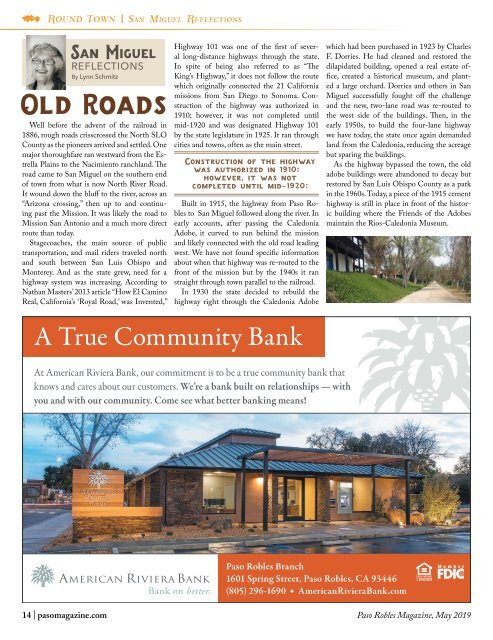
As the highway bypassed the town, the old<br />
adobe buildings were abandoned to decay but<br />
restored by San Luis Obispo County as a park<br />
in the 1960s. Today, a piece of the 1915 cement<br />
highway is still in place in front of the historic<br />
building where the Friends of the Adobes<br />
maintain the Rios-Caledonia Museum.<br />
14 | pasomagazine.com <strong>Paso</strong> <strong>Robles</strong> <strong>Magazine</strong>, <strong>May</strong> <strong>2019</strong>