Fall 2019

You also want an ePaper? Increase the reach of your titles
YUMPU automatically turns print PDFs into web optimized ePapers that Google loves.
lyn,” he said, “it should be clearly obvious<br />
how you get to the river and enjoy it.<br />
“Part of the development that we think<br />
is critically important is not just our site<br />
but circulation into our site and off our site.<br />
Circulation from other parts of the Brooklyn<br />
area so that folks can enjoy the amenities of<br />
our site as well as other areas. In other words,<br />
you need to be able to get from point A to<br />
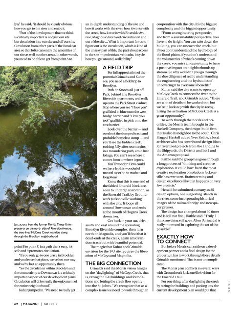
Just across from the former Florida Times-Union<br />
property on the north side of Riverside Avenue,<br />
the tree-lined McCoys Creek wanders along<br />
through the Brooklyn neighborhood.<br />
point B to point C in a path that’s easy, it’s<br />
safe and it promotes circulation.<br />
“If you only go to one place in Brooklyn<br />
and you leave that place, we’ve lost our way<br />
and we’ve lost an opportunity there.<br />
“So the circulation within Brooklyn and<br />
the connectivity to Downtown is a critically<br />
important aspect of our development plans.<br />
Circulation will drive really the enjoyment of<br />
the entire neighborhood.”<br />
Kuhar jumped in. “We need to really get<br />
an in-depth understanding of the site and<br />
how it works with the river, how it works with<br />
the creek, how it works with Riverside Avenue,<br />
Magnolia Street and circulation in and<br />
out of the site … What is important for us to<br />
figure out is the circulation, which is kind of<br />
the unsexy part of this, the part about access<br />
to the site — pedestrian, vehicular, bicycle,<br />
how you get around, walkability.”<br />
A field trip<br />
For full appreciation of the<br />
potential Grinalds and Kuhar<br />
see, you need a field trip to<br />
Brooklyn.<br />
Park on Stonewall just off<br />
Park, behind The Brooklyn<br />
Riverside apartments, and walk<br />
up onto the Park Street viaduct.<br />
Stop where you see “I love you”<br />
graffitied in blue onto the west<br />
bridge barrier and “I love you<br />
too!” graffitied in pink onto the<br />
east barrier.<br />
Look over the barrier — and<br />
overlook the dumped trash and<br />
probable homeless camp — and<br />
you’ll see the hidden creek,<br />
rushing fully after recent rains,<br />
in a meandering path, amid lush<br />
foliage. You can’t see where it<br />
comes from or where it goes.<br />
You’ll wonder: How could<br />
we have let this wonderful<br />
natural asset be so trashed and<br />
forgotten?<br />
Know that this is one end of<br />
the fabled Emerald Necklace,<br />
soon to undergo restoration, as<br />
the Emerald Trail, by Groundwork<br />
Jacksonville working<br />
with the city. It loops all<br />
around Downtown and ends<br />
at the mouth of Hogans Creek<br />
downriver.<br />
Get back in your car, drive<br />
south and east around the sprawling<br />
Brooklyn Riverside complex, then turn<br />
north on Magnolia, and you’ll find that it<br />
dead-ends at the creek, again amid random<br />
trash but with beautiful potential.<br />
The magic that Kuhar and Grinalds<br />
envision for the T-U site requires the liberation<br />
of McCoys and Magnolia.<br />
The big connection<br />
Grinalds said the Morris vision hinges<br />
on the “daylighting” of McCoys Creek, that<br />
is, razing the T-U buildings and foundations<br />
and letting the creek flow openly<br />
into the St. Johns. “We recognize that as a<br />
complex issue we need to work through in<br />
cooperation with the city. It’s the biggest<br />
complexity and the biggest opportunity.<br />
“From an engineering perspective<br />
and from a sustainability perspective, you<br />
have to do it right. You can take down the<br />
building, you can uncover the creek, but<br />
if you don’t understand the hydrology of<br />
the flood plains, if you don’t understand<br />
the volumetrics of what’s coming down<br />
the creek, you miss an opportunity to have<br />
a positive impact on neighborhoods upstream.<br />
So why wouldn’t you go through<br />
the due diligence of really understanding<br />
the engineering and the hydraulics of<br />
uncovering it to everyone’s benefit?”<br />
Kuhar said the city wants to open up<br />
McCoys Creek to connect the river to the<br />
Emerald Trail, and Grinalds added, “There<br />
are a lot of details to be worked out, but<br />
we’re in lockstep with the city in recognizing<br />
the activation of McCoys Creek is a<br />
great opportunity.”<br />
To work through the needs and priorities,<br />
the Morris team brought in the<br />
Haskell Company, the design-build firm<br />
that is also its neighbor to the south. Chris<br />
Flagg of Haskell added Yves Rathle, a local<br />
architect who has contributed design ideas<br />
for riverfront projects from the Landing to<br />
the Shipyards, the District and Lot J and<br />
the Amazon proposal.<br />
Rathle said the group has gone through<br />
a long process of “thinking and creative<br />
exploration. It could have been the most<br />
creative exploration of solutions Jacksonville<br />
has ever seen. Brainstorming and<br />
design excellence like that happens on very<br />
few projects.”<br />
He said he submitted as many as 25<br />
design options, one suggesting islands in<br />
the river, some incorporating historical<br />
images of the railroad bridge and newspaper<br />
presses.<br />
The design has changed about 30 times<br />
and is still not final, Rathle said. “Truly, I<br />
think anything still goes. Allen (Grinalds) is<br />
really interested in exploring the art of the<br />
possible.”<br />
Exactly how<br />
to connect<br />
But before Morris can settle on a development<br />
partner and a final design for the<br />
property, it has to work through those details<br />
Grinalds mentioned. That is not uncomplicated.<br />
The Morris plan conflicts in several ways<br />
with Groundwork Jacksonville’s vision for<br />
the Emerald Trail.<br />
For one thing, after daylighting the creek<br />
by razing the buildings and parking lots, the<br />
current development plan would put that<br />
BOB SELF<br />
62<br />
J MAGAZINE | FALL <strong>2019</strong>