

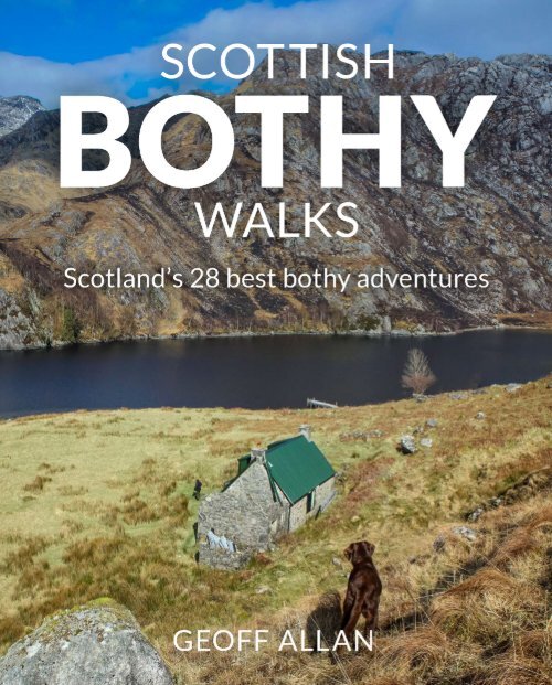
Scottish Bothy Walks - 28 best bothy adventures
Scottish Bothy Walks describes 28 sensational walking adventures, visiting Scotland’s finest bothies. Choosing his favourite bothies as the focal point, Geoff Allan guides the reader on a mix of day walks and multi-day excursions, highlighting the incredible mountains, wildlife, geography and history that you will find along the way. Combining beautiful photos, detailed route descriptions, points of interest and downloadable instructions, this is the ultimate companion for bothy-lovers and those exploring Scotland’s wilds, written by Scotland’s premier bothy expert.
Scottish Bothy Walks describes 28 sensational walking adventures, visiting Scotland’s finest bothies. Choosing his favourite bothies as the focal point, Geoff Allan guides the reader on a mix of day walks and multi-day excursions, highlighting the incredible mountains, wildlife, geography and history that you will find along the way. Combining beautiful photos, detailed route descriptions, points of interest and downloadable instructions, this is the ultimate companion for bothy-lovers and those exploring Scotland’s wilds, written by Scotland’s premier bothy expert.
- No tags were found...

You also want an ePaper? Increase the reach of your titles
YUMPU automatically turns print PDFs into web optimized ePapers that Google loves.
SCOTTISH<br />
BOTHY<br />
WALKS
f<br />
Orkney<br />
Islands<br />
Sea of the Hebrides<br />
Isle of<br />
Lewis<br />
g<br />
Isle of<br />
Skye<br />
j<br />
Islay<br />
h<br />
k<br />
Isle of Mull<br />
l<br />
7<br />
5<br />
6<br />
9<br />
w q<br />
Oban<br />
a<br />
8<br />
Isle of<br />
Arran<br />
4<br />
3<br />
1<br />
2<br />
Ullapool<br />
Inverness<br />
Fort William<br />
Ayr<br />
e r<br />
p<br />
Stirling<br />
s<br />
o<br />
Glasgow<br />
Perth<br />
d<br />
Elgin<br />
t<br />
y<br />
u i<br />
Forfar<br />
Wick<br />
Dundee<br />
Edinburgh<br />
Galashiels<br />
Hawick<br />
Moray Firth<br />
Fraserburgh<br />
Aberdeen<br />
St Andrews<br />
Peterhead<br />
Arbroath<br />
Berwick
CONTENTS<br />
EASTERN HIGHLANDS<br />
Table of <strong>Walks</strong>..................................6<br />
Introduction....................................9<br />
Bothies & <strong>bothy</strong>ing.............................13<br />
How to use this guide. . . . . . . . . . . . . . . . . . . . . . . . . . 16<br />
Clothing & other essentials .....................18<br />
Safety.........................................20<br />
NORTHERN HIGHLANDS<br />
01. Sandwood Bay & the bothies at<br />
Strathchailleach & Strathan .................24<br />
02. Beinn Leòid from Kylestrome<br />
visiting Glendhu & Glencoul.................32<br />
03. Suilven & Suileag <strong>Bothy</strong> from<br />
Glencanisp Lodge ..........................42<br />
04. Beinn Dearg Mòr & Shenavall <strong>Bothy</strong>..........50<br />
NORTH WEST HIGHLANDS<br />
05. Mesolithic Cave & Shell Midden<br />
beyond Craig <strong>Bothy</strong> in Torridon............... 62<br />
06. Coire Fionnaraich <strong>Bothy</strong> & a circuit of<br />
Maol Chean-dearg ........................ 68<br />
07. Uags <strong>Bothy</strong> &<br />
the Applecross Peninsula. . . . . . . . . . . . . . . . . . . 76<br />
08. Beinn Fhada & Camban <strong>Bothy</strong>...............82<br />
WESTERN HIGHLANDS<br />
09. Knoydart & the Rough Bounds via<br />
Sourlies <strong>Bothy</strong> .............................92<br />
10. Streap & Gleann Dubh-lighe <strong>Bothy</strong>......... 104<br />
11. Peanmeanach <strong>Bothy</strong> &<br />
the Ardnish Peninsula......................112<br />
CENTRAL HIGHLANDS<br />
12. Overnight at Staoineag <strong>Bothy</strong> ............. 120<br />
13. A Ben Alder crossing from Rannoch to<br />
Corrour station............................126<br />
14. Meall a’ Bhuachaille & Ryvoan <strong>Bothy</strong>....... 136<br />
15. Ben Macdui visiting Bob Scott’s <strong>Bothy</strong> &<br />
Hutchison Memorial Hut.......................142<br />
16. Callater Stables & Loch Kander ............ 152<br />
17. Lochnagar from Balmoral &<br />
Gelder Shiel Stables ...................... 158<br />
18. Beinn Dearg &<br />
Allt Scheicheachan <strong>Bothy</strong> ................. 166<br />
SOUTH WEST HIGHLANDS<br />
19. Beinn a’Chreachain &<br />
Beinn Achaladair via Gorton <strong>Bothy</strong>..........174<br />
20. Kilneuair by Loch Awe to Carron <strong>Bothy</strong> ..... 182<br />
SOUTHERN SCOTLAND<br />
21. Clennoch <strong>Bothy</strong> &<br />
Cairnsmore of Carsphairn................. 190<br />
22. Kettleton Byre & Scaw’d Law. . . . . . . . . . . . . . . 196<br />
THE ISLANDS<br />
23. Burnmouth Cottage, Rackwick Bay &<br />
The Old Man of Hoy....................... 204<br />
24. The Lookout & Rubha Hunish on Skye...... 210<br />
25. New Camasunary <strong>Bothy</strong>,<br />
the ‘Bad Step’ & Loch Coruisk . . . . . . . . . . . . . . 216<br />
26. Dibidil <strong>Bothy</strong> & the Rùm Cuillin ............ 224<br />
27. Beinn Talaidh &<br />
Tomsleibhe <strong>Bothy</strong>, Mull ................... 234<br />
<strong>28</strong>. Jura’s remote coastal bothies Cruib &<br />
Ruantallain .............................. 240<br />
APPENDIX<br />
Munros, Corbetts & Grahams................. 250<br />
Gaelic glossary .............................. 251<br />
Bibliography................................. 252<br />
Copyright & Acknowledgements .............. 256<br />
5
NO. NAME DISTANCE WALKING TIME TOTAL ASCENT<br />
01 Sandwood Bay & the bothies at Strathchailleach & Strathan 22km/14 miles 7.5-9.5 hours (over 2 days) 520m<br />
02 Beinn Leòid from Kylestrome visiting Glendhu & Glencoul 36km/22.5 miles 11-14 hours (over 3 days) 1200m<br />
03 Suilven & Suileag <strong>Bothy</strong> from Glencanisp Lodge 19km/12 miles 6-8 hours 836m<br />
04 Beinn Dearg Mòr & Shenavall <strong>Bothy</strong> 25km/15.5 miles 8-10 hours 1530m<br />
05 Mesolithic Cave & Shell Midden beyond Craig <strong>Bothy</strong> in Torridon 12km/7.5 miles 4-5 hours 154m<br />
06 Coire Fionnaraich <strong>Bothy</strong> & a circuit of Maol Chean-dearg 19km/12 miles 6-7 hours 713m<br />
07 Uags <strong>Bothy</strong> & the Applecross Peninsula 11km/7 miles 4-5 hours 169m<br />
08 Beinn Fhada & Camban <strong>Bothy</strong> 25.75km/16 miles 8-10 hours 1234m<br />
09 Knoydart & the Rough Bounds via Sourlies <strong>Bothy</strong> 44km/27.25 miles 14-17 hours (over 2 days) 1790m<br />
10 Streap & Gleann Dubh-lighe <strong>Bothy</strong> 17.5km/11 miles 6-8 hours 1197m<br />
11 Peanmeanach <strong>Bothy</strong> & The Ardnish Peninsula 11km/7 miles 4-5 hours 187m<br />
12 Overnight at Staoineag <strong>Bothy</strong> 17km/10.5 miles 5-6 hours (over 2 days) 100m<br />
13 A Ben Alder Crossing from Rannoch to Corrour Station 30km/18.5 miles 9-11 hours (over 2 days) 750m<br />
14 Meall a’ Bhuachaille & Ryvoan <strong>Bothy</strong> 9km/5.5 miles 4.5-5.5 hours 570m<br />
15 Ben Macdui visiting Bob Scott’s <strong>Bothy</strong> & Hutchison Memorial Hut 32km/20 miles 10-12 hours 1440m<br />
16 Callater Stables & Loch Kander 19m/12 miles 6-8 hours 790m<br />
17 Lochnagar from Balmoral & Gelder Shiel Stables 21km/13 miles 6-8 hours 1089m<br />
18 Beinn Dearg & Allt Scheicheachan <strong>Bothy</strong> 29km/18 miles 9-11 hours 1377m<br />
19 Beinn a’Chreachain & Beinn Achaladair via Gorton <strong>Bothy</strong> 25.5km/15.5 miles 8-10 hours 1300m<br />
20 Kilneuair by Loch Awe to Carron <strong>Bothy</strong> 17km/10.5 miles 5-6 hours 727m<br />
21 Clennoch <strong>Bothy</strong> & Cairnsmore of Carsphairn 18km/11 miles 6-7 hours 890m<br />
22 Kettleton Byre & Scaw’d Law 12km/7.5 miles 3.5-4.5 hours 590m<br />
23 Burnmouth Cottage, Rackwick Bay & The Old Man of Hoy 11km/7 miles 4-5 hours 190m<br />
24 The Lookout & Rubha Hunish on Skye 4km/2.5 miles 3-4 hours 93m<br />
25 New Camasunary <strong>Bothy</strong>, the ‘Bad Step’ & Loch Coruisk 29km/18 miles 10-12 hours 670m<br />
26 Dibidil <strong>Bothy</strong> & the Rùm Cuillin 20.5km/13 miles 10-12 hours 1900m<br />
27 Beinn Talaidh & Tomsleibhe <strong>Bothy</strong>, Mull 18km/11 miles 5-6 hours 748m<br />
<strong>28</strong> Jura’s remote coastal bothies Cruib & Ruantallain 27km/17 miles 9-12 hours (over 3 days) 140m<br />
6
TABLE OF WALKS<br />
SUMMITS NAVIGATION TERRAIN DIFFICULTY<br />
Straightforward Challenging Straightforward<br />
Beinn Leòid (Corbett), 792m Challenging Challenging Challenging<br />
Caisteal Liath (Corbett), 731m Easy Straightforward Straightforward<br />
Beinn Dearg Mòr (Corbett), 906m<br />
Straightforward<br />
Challenging (steep<br />
climb)<br />
Challenging<br />
Easy Easy Easy<br />
Straightforward Easy Straightforward<br />
Easy Easy Easy<br />
Beinn Fhada (Munro), 1032 m; Sgùrr a’ Dubh Doire<br />
(Munro Top), 962m<br />
Challenging Straightforward Challenging<br />
Straightforward Straightforward Challenging<br />
Meall an Uillt Chaoil, 844m; Stob Coire nan Cearc, 887m;<br />
Streap (Corbett), 909m; Streap Comhlaidh, 898m<br />
Straightforward<br />
Straightforward/<br />
Challenging<br />
Straightforward/<br />
Challenging<br />
Easy Easy Straightforward<br />
Easy Easy Straightforward<br />
Easy Challenging Challenging<br />
Easy Easy Easy<br />
Ben Macdui (Munro), 1309m; Stob Coire Sputan Dearg<br />
(Munro Top), 1249m; Sròn Riach (Munro Top), 1113m<br />
Challenging<br />
Straightforward/<br />
Challenging<br />
Challenging<br />
Easy Straightforward Straightforward<br />
Lochnagar/Cac Carn Beag (Munro), 1115m; Cac Carn Mòr, 1150m Straightforward Straightforward<br />
Straightforward/<br />
Challenging<br />
Beinn Dearg (Munro), 1008m Straightforward Straightforward Challenging<br />
Beinn a’Chreachain (Munro), 1081m; Meall Buidhe (Munro Top), 978m;<br />
Beinn Achaladair (Munro), 1038m; South Top, 1002m<br />
Straightforward Straightforward Challenging<br />
Easy Easy Straightforward<br />
Cairnsmore of Carsphairn (Corbett), 797m;<br />
Beninner (Donald Top), 710m<br />
Scaw’d Law (Donald), 663m; Little Scaw’d Law, 594m; Glenleith Fell<br />
(Donald Top), 612m–quick detour from route<br />
Straightforward Straightforward Straightforward<br />
Easy Easy Easy<br />
Easy Easy Easy<br />
Askival (Corbett), 812m; Ainshval (Corbett), 781m; Trollabhal (Graham),<br />
702m; Sgùrr nan Gillean (Corbett Top), 764m; Hallival, 723m.<br />
Easy<br />
Easy<br />
Easy (one short<br />
scramble)<br />
Hard (serious rock<br />
traverse)<br />
Easy<br />
Challenging<br />
Challenging Hard (ridge scramble) Challenging<br />
Beinn Talaidh (Graham), 761m Easy Straightforward Straightforward<br />
Challenging Challenging Challenging<br />
7
APPROACHING THE ‘BAD STEP’ ON SKYE (WALK 25)
INTRODUCTION<br />
<strong>Bothy</strong> <strong>Walks</strong> is a natural companion to<br />
my first book, The <strong>Scottish</strong> <strong>Bothy</strong> Bible.<br />
In this volume, I showcase some of the<br />
<strong>best</strong> bothies in the country, setting out a range<br />
of short hikes, mountain climbs and multi-day<br />
expeditions using these unique shelters as a<br />
focal point. Over the last two years I have eagerly<br />
retraced my steps around the <strong>bothy</strong> network,<br />
checking out routes for inclusion here, and<br />
adding a raft of new images to my photographic<br />
archive. My aim has been to tempt you out into<br />
Scotland’s rugged and beautiful landscape,<br />
whatever your level of ability. The walks range<br />
from a stroll along the cliffs above Rackwick Bay<br />
to the Old Man of Hoy on the Orkney Archipelago,<br />
to a challenging traverse of the ‘Bad Step’<br />
on Skye. As well as including all the essential<br />
technical details, each entry offers a taste of what<br />
makes the area special, from its unique geology,<br />
wildlife and flora, to the intriguing history<br />
and culture of its people. And there are a few<br />
personal reminiscences along the way...<br />
Even after more than 30 years spent exploring<br />
Scotland’s nooks and crannies, I still feel a surge<br />
of anticipation and delight when I see a <strong>bothy</strong> in<br />
the distance, even if I have visited it many times<br />
before. My <strong>adventures</strong> into the <strong>bothy</strong> world began<br />
during my student days in the late-1980s, when I<br />
became an enthusiastic member of the Edinburgh<br />
University Mountaineering Club. By my second<br />
year of study, I was <strong>bothy</strong> secretary for the club<br />
hut, Glenlicht House, tucked away beneath the<br />
mountains of Kintail, and had begun to seek out<br />
<strong>bothy</strong> locations. At the time, these were closely<br />
guarded secrets, held only by a knowledgeable<br />
few. One of my first discoveries was the Mountain<br />
Bothies Association (MBA) <strong>bothy</strong> at Camban<br />
(described in Walk 8), which sits on the lonely pass<br />
between Glen Affric and Gleann Lichd. I vividly<br />
remember staring up at the mist-laden Munros<br />
surrounding the <strong>bothy</strong>, not quite believing that this<br />
isolated refuge was free to use by anyone who had<br />
the wherewithal to get there. Soon I had acquired<br />
a prized copy of the MBA <strong>bothy</strong> grid references<br />
(finally published online by the MBA in 2009),<br />
and stumbled upon Irvine Butterfield’s 1972<br />
Survey of Shelters in Remote Mountain Areas<br />
of the <strong>Scottish</strong> Highlands. This treasure trove of<br />
information became the basis of my own precious<br />
<strong>bothy</strong> list, and inspired an even greater passion to<br />
travel around the country.<br />
Through my love affair with bothies I have<br />
developed an intimate personal relationship<br />
with the <strong>Scottish</strong> Highlands, a bond that has<br />
only intensified since the autumn of 2011, when<br />
I hit upon the idea of producing a countrywide<br />
<strong>bothy</strong> guide. Without the use of a car, it took five<br />
years to complete the survey and research all<br />
the background material – the vast majority of<br />
fieldwork undertaken using my trusty bike and<br />
public transport. With the luxury of time, I have<br />
been lucky enough to rediscover the country at a<br />
slower pace and get a deeper feel for the history<br />
that has played out across the landscape over<br />
millennia. The <strong>Scottish</strong> <strong>Bothy</strong> Bible was finally<br />
published in March 2017 and went on to win UK<br />
Travel Guidebook of the Year.<br />
Much thought has been invested in choosing<br />
the walks and bothies in this guide. The<br />
selection represents my absolute favourite<br />
9
othy locations with the most memorable and<br />
beautiful approaches. You will find routes that<br />
not only range over the whole of Scotland, but<br />
also are suitable for a broad spectrum of fitness<br />
levels and experience. I have included a mix of<br />
day walks and multi-day <strong>adventures</strong>, and have<br />
been conscious not to create itineraries that<br />
are too complex or that replicate suggestions in<br />
other <strong>Scottish</strong> walking books. All the day walks<br />
return to the same location, whether circular or<br />
there-and-back, so there is no requirement for<br />
two cars or an anxious hitch-hike to retrieve a<br />
vehicle. It is also important to emphasise that<br />
each <strong>bothy</strong> is a worthy objective in itself, as well<br />
as a base from which to climb mountain tops<br />
or explore additional places of interest. On a<br />
dreich morning or a lazy sunny afternoon I have<br />
often set out to visit a <strong>bothy</strong> just to have a look<br />
around. Happiness comes from the satisfaction<br />
of having a simple objective combined with the<br />
opportunity to venture off the beaten track.<br />
Creating The <strong>Scottish</strong> <strong>Bothy</strong> Bible was a lifechanging<br />
experience for me, and I hope <strong>Scottish</strong><br />
<strong>Bothy</strong> <strong>Walks</strong> will encourage even more people<br />
out into the hills. Enjoy the descriptions of the<br />
walks and the photographs that accompany them.<br />
Hopefully they will inspire you to make your own<br />
journeys and build lasting relationships with the<br />
bothies and mountains that I know and love.<br />
10
CROSSING THE PARPH, SOUTH OF CAPE WRATH (WALK 11 1)
STRATHCHAILLEACH 12<br />
BOTHY (WALK 1)
BOTHIES & BOTHYING<br />
‘A simple shelter in remote<br />
country for the use and benefit<br />
of all who love being in wild and<br />
lonely places’.<br />
Definition from the MBA members’ handbook<br />
Scotland’s bothies are a loose collection of<br />
shepherds’ cottages, estate houses and<br />
abandoned crofts that have been saved<br />
from ruin and renovated. They form a network of<br />
basic shelters located throughout the country’s<br />
most remote and uninhabited regions. Freely<br />
available for anyone to use as a lunch stop, or<br />
to stay in overnight, bothies have been used by<br />
mountaineers and stravaigers for well over a<br />
hundred years and become integral to Scotland’s<br />
outdoor culture.<br />
In very simple terms, there are many derelict<br />
properties scattered across the <strong>Scottish</strong><br />
landscape because of the waves of depopulation<br />
that began in the mid- to late-18th century and<br />
did not ease until after World War II. The initial<br />
driving force behind the exodus was a process<br />
of forced evictions known as the ‘Highland<br />
Clearances’. People then continued to abandon<br />
their communities when harvest failures led to<br />
illness and famine, with many leaving for the<br />
industrial heartland that grew rapidly in Lowland<br />
Scotland through the Victorian era.<br />
The term <strong>bothy</strong> derives from the Gaelic bothan<br />
(via the Old Irish both) meaning hut, and originally<br />
described rough-and-ready accommodation<br />
provided by landowners for farm labourers or<br />
estate workers. More recently the term has<br />
become synonymous with an idea of sanctuary<br />
and shelter. This cultural transition began in the<br />
1930s, with the rise in popularity of hillwalking<br />
among the urban populations of Glasgow,<br />
Edinburgh and Aberdeen. Short of money, but<br />
with more leisure time on their hands, groups<br />
of mainly young men used these partly derelict<br />
cottages as places to congregate and sleep for<br />
free during hard-earned weekends. In some cases<br />
this practice was clandestine, but increasingly,<br />
various estates gave their tacit consent.<br />
The rural exodus following World War II left an<br />
increasing number of farmhouses unoccupied,<br />
and walkers simply started using them as<br />
somewhere to stay overnight. By the 1960s,<br />
however, the fabric of many of these properties<br />
began to suffer through misuse and lack of<br />
maintenance. A few were cared for by climbing<br />
clubs, but the remainder received little attention.<br />
I strongly believe the <strong>bothy</strong> tradition in its<br />
current form would not have endured without<br />
the invention of the MBA, which came into<br />
existence in 1965. Bernard Heath, a keen cyclist<br />
and hillwalker was inspired by a chance remark<br />
in a <strong>bothy</strong> book suggesting the establishment<br />
of a club to keep bothies in good repair. He and<br />
a few of his friends decided to restore the ruins<br />
of Tunskeen Farm in Galloway, and the following<br />
November a group of like-minded individuals<br />
gathered in nearby Dalmellington village hall<br />
where the Mountain Bothies Association was<br />
born. During the next five decades the MBA<br />
extended its renovation work across the country,<br />
as well as taking over the upkeep of many bothies<br />
maintained by various climbing clubs. Today<br />
there are over 80 MBA bothies in Scotland as<br />
START BAY, FROM START 13 POINT
PEANMEANACH BOTHY (WALK 11)<br />
INSIDE 14 STRATHCHAILLEACH BOTHY (WALK 1)
well as 21 in England and Wales. In 2015, when<br />
the organisation celebrated its 50th anniversary,<br />
it received The Queen’s Award for Voluntary<br />
Service – the highest accolade for a voluntary<br />
group in the UK.<br />
WHAT TO EXPECT<br />
Bothies come in many shapes and sizes,<br />
but the most common configuration is the<br />
classic two-roomed cottage referred to by its<br />
Scots term, but and ben. The ‘but’ referring to<br />
the kitchen and living room, and the ‘ben’ the<br />
bedroom. Accommodation is very rudimentary,<br />
and in almost all cases there is no gas, electricity,<br />
tap, or toilet. You should expect only a wind- and<br />
waterproof building that offers somewhere dry<br />
to sleep. If you are staying overnight, you will<br />
need to carry in all the equipment you would<br />
normally take camping, plus candles and, if there<br />
is a fireplace, fuel to burn. As a bare minimum,<br />
bothies will have a table and a couple of chairs,<br />
but many also have sleeping platforms and<br />
stoves. Water comes from a nearby stream and,<br />
although some bothies have latrines or loos,<br />
answering calls of nature will involve a walk and<br />
the use of a spade.<br />
Bothies can look romantic, but in reality they<br />
can be cold, dusty, damp, and pretty dark. Yet<br />
in the evening, with the fire blazing, candles<br />
burning, hot food on the table and a glass of<br />
wine at your elbow, the place is transformed.<br />
Some (myself included) just like to go ‘<strong>bothy</strong>ing’<br />
– setting off for the weekend without any other<br />
objective in mind – and many bothies have been<br />
adopted as a home from home. Evenings can be<br />
peaceful or convivial, so respect other users as<br />
well as the <strong>bothy</strong> itself. Each shelter has at least<br />
one dedicated MBA maintenance officer who<br />
volunteers their services to look after the fabric<br />
of the building and when major renovations<br />
are required, the MBA organises work parties. I<br />
would wholeheartedly recommend joining the<br />
MBA to support all their good work.<br />
LOCATING BOTHIES<br />
Bothies differ from other systems of mountain<br />
huts and refuges around the world in a number<br />
of subtle and distinctive ways. Because only a<br />
very small number have been purpose-built, the<br />
location of the majority is fairly random. They<br />
are not necessarily close to a particular peak or<br />
spaced at equal distances along a recognised<br />
long-distance walk. Neither are they tied to<br />
any specific National Park. They are found right<br />
across the country, some in very remote places<br />
that are rarely visited. Another intriguing element<br />
is the past reticence about advertising the<br />
network. Except in a very few cases, the word<br />
<strong>bothy</strong> has not been printed on any OS maps;<br />
only the name of the building. And on the ground<br />
there are few signposts to point the way. As I<br />
explain in the next section, you cannot rely on<br />
this guide alone, but in combination with the<br />
right OS map you should be able to find your way<br />
with ease.<br />
15
NORTHERN<br />
HIGHLANDS
WALKING IN TO SANDWOOD BAY
WALK 1<br />
SANDWOOD BAY & THE BOTHIES AT<br />
STRATHCHAILLEACH & STRATHAN<br />
Two-day expedition to Scotland’s far northwestern<br />
corner, combining sensational Sandwood<br />
Bay with visits to two of Scotland’s most<br />
remote and picturesque bothies.<br />
Exposed to the hypnotic rhythm of the North Atlantic<br />
swell, Sandwood is the jewel among the unspoiled bays<br />
of Scotland’s precious coastal fringes. Yet this dynamic,<br />
sweeping stretch of platinum-blonde sand, high dunes, and<br />
rugged cliff, with a distinctive sea stack at its southern end,<br />
remains remarkably untouched. Footprints are the only marks<br />
left at the turn of each tide. Owned by the John Muir Trust since<br />
1993, the mile and a half of strand has become better known of<br />
late, but is never crowded and retains its wild feel.<br />
Inland lies the Parph, a remote, trackless expanse of peat and<br />
upland moor that is home to two special bothies, each with a<br />
fascinating story. Strathchailleach (Valley of the Old Woman), to<br />
the north-east, lays claim to be the last permanently inhabited<br />
building in the UK without any piped water, gas or electricity,<br />
and was occupied as recently as 1996. Strathan, to the south,<br />
had temporary residents in 2000 when a couple moved in with<br />
the intention of setting up a working croft, only to be evicted<br />
four months later. Those inspired to travel so far north and<br />
undertake this truly remarkable journey – unique in Britain – will<br />
always treasure the memory.<br />
Day 1. It is a fair step to Sandwood and on to Strathchailleach,<br />
but if you are lucky with the weather, <strong>bothy</strong> walk-ins don’t get<br />
much better than this. 1 From the car park at Blairmore, a wellmaintained<br />
track threads its way through common grazing land,<br />
past a series of fetching lochans all the way to the bay. As the<br />
trail contours round Druim na Buainn, the dunes come<br />
INFORMATION<br />
MAPS: LR 9 Cape Wrath,<br />
Explorer 446 Durness & Cape<br />
Wrath.<br />
START/END GRID REF: NC 195<br />
601. John Muir car park at<br />
Blairmore: toilets and drinking<br />
water on site. Donations<br />
welcome.<br />
DISTANCE: 22.5km/14 miles<br />
DAY 1: 10.5km/6.5 miles<br />
TIME: 3.5–4.5 hours<br />
DAY 2: 12km/7.5 miles<br />
TIME: 4 –5 hours<br />
TOTAL ASCENT: 520m<br />
HIGHEST POINT: 230m<br />
NAVIGATION: Straightforward<br />
TERRAIN: Challenging. Tracks,<br />
faint trails, open moor.<br />
DIFFICULTY: Straightforward<br />
PUBLIC TRANSPORT: <strong>Scottish</strong><br />
Citylink service 961/Stagecoach<br />
Highland service 61 Inverness-<br />
Ullapool. Durness Bike Bus<br />
(01463 419160) and The<br />
Durness Bus (01971 511223)<br />
Group booking bus service.<br />
North West Community Bus<br />
Association’s service 890<br />
Ullapool to Kinlochbervie<br />
(01971 521054).<br />
SPECIAL NOTES: Both bothies<br />
are open all year round.<br />
Sandwood Bay is a nature<br />
reserve owned and managed<br />
by the John Muir Trust. Keep<br />
dogs under control to avoid<br />
disturbing free-roaming sheep<br />
and ground-nesting birds.<br />
25
WALK 1 Sandwood Bay & the bothies at Strathchailleach & Strathan<br />
enticingly into view, while cliffs to the north of<br />
the bay snake away up to Cape Wrath. On a clear<br />
day you can just glimpse the lighthouse on the<br />
promontory, a bright white speck on the horizon.<br />
Before it was built in 18<strong>28</strong>, the coastline was<br />
notorious for shipwrecks and locals still tell of<br />
the ghostly mariner who roams the strand on<br />
stormy nights.<br />
2 From here, you are irresistibly drawn<br />
down to the wide expanse of sandy shoreline<br />
stretching away into the distance, the sound of<br />
the waves a constant presence. Walking out to the<br />
breakers, the monumental stack, Am Buachaille<br />
(the Herdsman), makes its presence felt, with the<br />
rocky outcrop, Am Balg, visible a little further out.<br />
Alongside the sand, a huge dune system has built<br />
up over millennia, evidence of the wind’s immense<br />
power in this exposed location. Even on a sunkissed<br />
afternoon there is always a hint of a breeze,<br />
while in winter, hurricane-force gales whip in from<br />
the Atlantic. Home to ground-nesting dunlins<br />
and ringed plovers, the sand is held in check by<br />
marram grass. Beyond, a carpet of rare machair<br />
leads back to freshwater Sandwood Loch.<br />
Striding up to the north end of the beach, you<br />
reach the brackish outflow from the loch, a wide<br />
channel that is easily crossed in dry conditions<br />
but in times of spate is more of a challenge and<br />
<strong>best</strong> tackled close to the shore. Few visitors<br />
venture this far, and you may have the rest of<br />
the beach to yourself. 3 Once up through the<br />
broken rocks to the clifftop, it is tempting to<br />
plough straight across the moor towards Lochan<br />
nan Sac, then onto the Strathchailleach, hidden<br />
between the peat hags. However, easier terrain is<br />
found on a vague path along the southern bank<br />
of the Strath Chailleach, which meanders round<br />
to the <strong>bothy</strong>, though it adds another half a mile<br />
to the walk. From late spring, pink lousewort<br />
and round leaf orchids can be found among tall<br />
cotton grass and prostrate juniper. And if you are<br />
keen, there is a chance to wild swim in one of the<br />
numerous pools.<br />
Strathchailleach <strong>Bothy</strong> is a tiny stone cottage<br />
with a low facade, and most need to stoop before<br />
stepping over the threshold into the world of<br />
hermit James MacRory-Smith. Known locally as<br />
Sandy, he was a cantankerous old soul, who lived<br />
here without running water, gas or electricity for<br />
32 years, before ill health forced him to leave in<br />
1996. The interior’s most distinctive feature is<br />
a series of simple frescoes he painted over the<br />
years, some with astrological themes. Although<br />
his home-made bellows have been removed and<br />
the kitchen area is now a two-person dormitory,<br />
as you sit in front of a slow-burning peat fire<br />
(from the ample supplies cut by the generous<br />
maintenance officer), Sandy’s presence is almost<br />
palpable. The few he invited into his abode might,<br />
if the mood took him, be regaled with stories<br />
of his hermit’s life. Increasingly used by hikers<br />
finishing the Cape Wrath Trail as well as visitors<br />
curious to see this living museum, the <strong>bothy</strong> now<br />
boasts additional bunk beds.<br />
Day 2. Leaving for Strathan, there is a frisson<br />
of anticipation as you envisage the route ahead<br />
across the pathless moor. 4 Head due south<br />
over the stile in the sheep fence, climbing steadily<br />
past Lochan Beul na Faireachan, and on to the<br />
shoulder of An Grianan. It is slow-going if the<br />
26
STRATHCHAILLEACH BOTHY 27
WALK 1 Sandwood Bay & the bothies at Strathchailleach & Strathan<br />
STRATHAN BOTHY<br />
<strong>28</strong>
WALK 1 Sandwood Bay & the bothies at Strathchailleach & Strathan<br />
terrain is saturated, but it gets easier with altitude<br />
as the vegetation thins. 5 From a high point,<br />
pick a line down to the valley below, crossing a<br />
number of small tributaries that funnel down<br />
to the river. It is exhilarating being in such open<br />
terrain, using your experience to measure the lie<br />
of the land, and steer a course as efficiently as<br />
possible down to the floodplain. The key point<br />
of orientation, especially in poor visibility, is the<br />
sharp meander where the V-shaped notch of<br />
the Allt a Ghleannain rushes down into the main<br />
channel. Once across this stream, a faint but<br />
increasingly obvious path leads on to the <strong>bothy</strong><br />
at Strathan just over 500 yards further on, its<br />
bright red front door a most welcome sight.<br />
Similar in style to Strathchailleach, the <strong>bothy</strong> is<br />
set in good pastureland, the river and an old well<br />
are close by, and there is a peat bank with bricks<br />
built up to dry over the summer. No wonder this<br />
secluded spot attracted the attention of Robbie<br />
and Anne Northway, a travelling couple who quite<br />
brazenly moved in during the spring of 2000.<br />
They intended to set up a working croft, to the<br />
consternation of the MBA and local community.<br />
After four months of campaigning, and police<br />
intervention, the couple were evicted, leaving the<br />
cottage open to all once more.<br />
After walking over from Strathchailleach<br />
through wild, trackless land, there is a reasonably<br />
clear path back to the single-track road from<br />
Kinlochbervie out to Blairmore. However, the<br />
terrain can be rather tough-going where the trail,<br />
surrounded by a swathe of waterlogged peatbog,<br />
picks its way along the shoreline of two small<br />
lochs. 6 Once over the suspension footbridge,<br />
you follow the faint path zigzagging up the slope.<br />
At the top of the rise and looking out over the<br />
flat expanse of peatland to the coast, you can<br />
trace the inward route to Sandwood, a yellow<br />
smudge in the distance. Once past the two<br />
lochans, concentrate hard and keep the path in<br />
sight so you don’t end up knee-deep in the bog!<br />
7 Fortunately, you can follow a line of wooden<br />
poles (quite widely spaced) heading west back<br />
to a farm track, and onto the road. The house at<br />
the roadside doesn’t seem to get any closer for<br />
an inordinate amount of time, but then suddenly<br />
you are back in civilisation, elated to have<br />
achieved your goal. On the final mile back to the<br />
car park you can relax and relive the experience<br />
of a fantastic expedition. There is nothing quite<br />
like it in the whole of the UK.<br />
Notes: The route described is split into two<br />
days. It is quite feasible to complete the circuit in<br />
one day, though this is only recommended in the<br />
summer months with long daylight hours. The<br />
terrain across the Parph can be quite unforgiving<br />
underfoot so allow additional time. The first<br />
section of the route follows the route of the Cape<br />
Wrath Trail.<br />
29
WALK DIRECTIONS<br />
1 Sandwood Bay & the bothies at Strathchailleach & Strathan<br />
Day 1<br />
Blairmore to Strathchailleach<br />
1 From the John Muir Trust<br />
(JMT) car park at Blairmore<br />
head along the track<br />
signposted to Sandwood,<br />
through a gate blocking<br />
vehicular access, past a series<br />
of lochans to the bay,<br />
following the route of the<br />
Cape Wrath Trail.<br />
6.5km/4 miles<br />
2 Traverse the beach<br />
heading N, crossing the<br />
outflow from Sandwood Loch,<br />
which can be a hazard when<br />
in spate.<br />
0.8km/0.5 miles<br />
3 Ascend the broken rocks<br />
to the clifftop just beyond the<br />
outflow, then walk along the<br />
cliff to the riverbank of the<br />
Strath Chailleach at (NC 232<br />
663). Negotiate the sheep<br />
fence and walk inland,<br />
following the meanders of the<br />
Strath Chailleach, then cut<br />
across the final section of<br />
moor to follow the faint path<br />
all the way to the <strong>bothy</strong><br />
(NC 249 658). Alternatively<br />
from the clifftop head straight<br />
across the pathless moor ENE<br />
past Lochan nan Sac. Head on<br />
to a stile in the sheep fence<br />
(NC 244 657) and quickly<br />
reach the <strong>bothy</strong>. Although this<br />
route is half a mile shorter, it<br />
is tough-going especially if the<br />
ground is saturated.<br />
3.2km/2 miles<br />
Day 2<br />
Strathchailleach to Blairemore<br />
4 From Strathchailleach<br />
<strong>Bothy</strong> head due S, climbing<br />
over a stile on the sheep fence<br />
running parallel to the glen<br />
(NC 244 657). From the <strong>bothy</strong><br />
door you can see the tall,<br />
wooden pole by the stile.<br />
Climb steadily up the pathless<br />
moor past Lochan Beul na<br />
Faireachan, and on to the W<br />
shoulder of An Grianan.<br />
2km/1.25 miles<br />
5 Pick out a route down into<br />
Strath Shinary, crossing a<br />
couple of small streams<br />
before reaching the E bank of<br />
the Abhainn an t-Srathain.<br />
Follow the river S to the sharp<br />
bend (NC 242 618), where the<br />
Allt a’ Ghleannain flows into<br />
the main channel. Once across<br />
this stream, a faint but<br />
increasingly obvious path<br />
leads on to the <strong>bothy</strong> at<br />
Strathan, just over 500 yards<br />
further on (NC 247 612).<br />
3.2km/2 miles<br />
6 From the <strong>bothy</strong> walk down<br />
to a suspension footbridge<br />
over the Abhainn an<br />
t-Srathain, and once across<br />
turn L along the bank for 200<br />
yds. Then pick up a path<br />
zigzagging up the slope onto<br />
the open moor. Skirt round<br />
the northern shore of two<br />
lochs following a boggy path.<br />
(Hard going in saturated<br />
conditions.)<br />
3.2km/2 miles<br />
7 At the S end of the second<br />
loch, Loch Mòr a’ Chraisg<br />
(NC 224 603), look for a faint<br />
path that follows a line of<br />
wooden poles set at wide<br />
intervals and then on to the<br />
track marked with a cairn<br />
(NC 212 602).<br />
1.3km/0.75 miles<br />
8 Continuing along the track,<br />
reach the single-track road<br />
from Kinlochbervie, turn R and<br />
follow it back to the car park<br />
at Blairmore.<br />
2.5km/1.5 miles<br />
30
WALK 1 Sandwood Bay & the bothies at Strathchailleach & Strathan<br />
0 1km<br />
0 1mile<br />
Sandwood<br />
Bay<br />
2<br />
3<br />
Lochan<br />
nan Sac<br />
4<br />
Druim na<br />
Buainn<br />
Sandwood Loch<br />
Carn an<br />
Righ<br />
Loch a'<br />
Mhuilinn<br />
5<br />
Lochain<br />
nan Sac<br />
Loch na<br />
Gainimh<br />
6<br />
1<br />
Balchrick<br />
Blairmore<br />
8<br />
7<br />
Loch Mor<br />
a'Chraisg<br />
31
GLENDHU BOTHY
WALK 2<br />
BEINN LEÒID FROM KYLESTROME<br />
VISITING GLENDHU & GLENCOUL<br />
A three-day voyage of discovery through backcountry<br />
east of Inchnadamph and Unapool,<br />
with an ascent of the remote Corbett, Beinn<br />
Leòid, from a lochside <strong>bothy</strong> base.<br />
I<br />
have a long-held fascination with the remote territory that lies<br />
beyond the closely linked bothies at Glendhu and Glencoul – a<br />
raw, ice-scoured hinterland of gnarly Lewisian gneiss, peat<br />
bog, and rugged moor, dotted with innumerable tiny lochans.<br />
I have heard said that within its lonely confines there is a<br />
remarkable gathering of red deer during the yearly rut, listened<br />
to enthusiastic anglers wax lyrical about the quality of the<br />
fishing (streams supposedly full to bursting with brown trout!)<br />
and also stumbled upon an intriguing tale of wild-cat footprints<br />
in the snow. Climbing Beinn Leòid (Macleod’s Hill), gives you<br />
an opportunity to venture into this rarely visited corner of the<br />
Highlands. Excellent stalkers’ paths transport you towards the<br />
peak, but the final approach crosses wild, trackless terrain. And,<br />
as soon as you step away from the recognised waypoints, you<br />
become immersed in a world of your own.<br />
The rock configuration underlying the topography in this<br />
region is hugely significant, forensically detailed in geological<br />
textbooks the world over. Older rocks, in this case the ancient<br />
metamorphic gneiss, were shifted over the comparatively<br />
younger Cambrian quartzite, over 400 million years ago. Over<br />
millions of years, this colossal movement – the ‘Moine Thrust’<br />
which occurred across the whole of north-west Scotland –<br />
gradually pushed rocks between 50 and 70 miles from their<br />
original home. The alignment caused controversy among<br />
geologists of the Victorian era, who subscribed to the theory<br />
that newer rocks were always laid on top of older ones.<br />
INFORMATION<br />
MAPS: LR15 Loch Assynt,<br />
Lochinver & Kylesku, Explorer<br />
442 Assynt & Lochinver<br />
(recommended).<br />
START/END GRID REF: NC 218<br />
345. Car park at Kylestrome<br />
just off the A894, 1 mile from<br />
Kylesku Bridge. Not signposted.<br />
DAY 1: 7km/4.5 miles<br />
TIME: 2–2.5 hours<br />
DAY 2: 22km/13.5 miles<br />
TIME: 7–9 hours<br />
DAY 3: 7km/4.5 miles<br />
TIME: 2–2.5 hours<br />
SUMMIT: Beinn Leòid (Corbett),<br />
792m<br />
TOTAL ASCENT: 1200m<br />
NAVIGATION: Challenging.<br />
TERRAIN: Challenging. Tracks,<br />
open hillside and steep<br />
boulder field.<br />
DIFFICULTY: Challenging.<br />
Requires confident hillcraft.<br />
PUBLIC TRANSPORT: <strong>Scottish</strong><br />
Citylink service 961/Stagecoach<br />
Highland service 61 Inverness-<br />
Ullapool. Durness Bike Bus<br />
(01463 419160) and The Durness<br />
Bus (01971 511223) Group<br />
booking bus services. North West<br />
Community Bus Association’s<br />
service 890 Ullapool to<br />
Kinlochbervie (01971 521054).<br />
SPECIAL NOTES: Bothies open<br />
all year. Phone Reay Forest<br />
Estate (01971 500221) if<br />
visiting during the stalking<br />
season, August 12–October 20.<br />
33
WALK 2 Beinn Leòid from Kylestrome visiting Glendhu & Glencoul<br />
The discovery added weight to then controversial<br />
ideas that the earth’s crust moved over time,<br />
causing earthquakes and volcanic eruptions.<br />
Contemporary theories of plate tectonics and<br />
continental drift have become accepted only in<br />
the last few decades.<br />
1 Walking down by the newly refurbished<br />
estate house from Kylestrome towards the shore<br />
of Loch Glendhu, it is hard to believe that this<br />
tranquil spot was once the public highway, shown<br />
on the old one-inch map as ‘a narrow class A road<br />
with passing places’. Before the eye-catching<br />
Kylesku Bridge was completed in 1984, a small<br />
turntable ferry plied its trade across the strait,<br />
with the inevitable long queues of traffic on<br />
the journey up and back from Durness. As the<br />
tarmac curves down to the old slipway, turn left<br />
onto the old pony path that winds its way inland<br />
towards the Maldie Burn. A mile from the car<br />
park, a new unmetalled road joins from the left;<br />
it was built to provide access to a hydroelectric<br />
scheme damming the powerful stream below<br />
Loch an Leathaid Bhuain. 2 Beyond the concrete<br />
bridge over the burn, the track returns to its<br />
original stony surface, in places negotiating a<br />
precarious course between the rock face and<br />
the lochside, before Glendhu <strong>Bothy</strong> finally comes<br />
into view. Close to the <strong>bothy</strong> it is easy to spot the<br />
slanting band of quartzite with a slightly red hue,<br />
which forms a sheer cliff that slopes down to the<br />
waterside. This continues round the headland<br />
into Loch Glencoul, sandwiched between the<br />
layers of gneiss.<br />
There are three buildings at the head of the<br />
loch: an old stalkers’ cottage, a small stone<br />
stables, and the well-appointed <strong>bothy</strong>, one of<br />
the <strong>best</strong> on the MBA roster. The last full-time<br />
tenants in the main house, the Elliots, moved<br />
here from Glencoul in the 1950s, where they had<br />
been resident since before the turn of the 20th<br />
century. During the summer months, a ghillie<br />
lived upstairs in the <strong>bothy</strong>, using one downstairs<br />
room as a living room, and the other for storing<br />
the deer carcasses shot by paying guests who<br />
travelled in by boat from Kylesku. The last of the<br />
family to live at Glendhu, John Elliot and his son<br />
Willie, finally moved out a few years later, though<br />
their descendants still keep a close connection<br />
to the area.<br />
3 It is wise to make an early start for the<br />
following day’s ascent: tackling the open hillside<br />
can take far longer than you anticipate, even in<br />
dry conditions. The crags of Taobh Granda are<br />
an imposing presence as you make your way<br />
up Gleann Dubh (Black Glen), the sun barely<br />
catching the north-facing rocks for much of the<br />
year. As the valley sides knot together in a tight,<br />
interlocking spur, the stalkers’ path zigzags<br />
steeply above the cascading river, before levelling<br />
out as it reaches Lochan Cadh’ Allein. 4 Cross<br />
34
LOCH GLENDHU<br />
GLENDHU BOTHY 35
WALK 2 Beinn Leòid from Kylestrome visiting Glendhu & Glencoul<br />
BEINN LEÒID FROM BEINN A’ BHÙTHA<br />
36 GLEANN DUBH
WALK 2 Beinn Leòid from Kylestrome visiting Glendhu & Glencoul<br />
the Abhainn a’ Ghlinne Dhuibh via a solidly built<br />
vehicle bridge, and ascend steadily below the<br />
bluffs of Cnoc a’ Mhadaidh, following the path as<br />
it contours up towards the exposed upland moor.<br />
Once across Allt Poll a’ Mhadaidh, which can<br />
be an obstacle in times of spate, the track rises<br />
more steeply before coming to an abrupt halt at a<br />
rather incongruously placed wooden bridge, lost<br />
in the midst of its grand surroundings.<br />
5 Now steel yourself for a battle through the<br />
peat hags and bog, before reaching more solid<br />
ground on the slopes of Sàil na Slataich. With<br />
some relief, the pace quickens over the gently<br />
slanting slabs to the high point of 652m. Up ahead<br />
Beinn Leòid rises serenely, guarded by a steep<br />
boulder field. Clamber through the rocks and onto<br />
the summit plateau where a stunning 360-degree<br />
panorama opens up. Looking back north, the<br />
shattered quartzite slopes of Arkle and Foinaven<br />
dominate the scene, and to the east the silvery<br />
outline of Loch Shin slips away to the horizon.<br />
The complex coires of Quinag take centre stage<br />
to the west and Ben More Assynt and Conival<br />
rear up to the south, while the tops of Suilven and<br />
Canisp are just visible above the whaleback ridge<br />
of Beinn Uidhe. And as far as the eye can see, an<br />
abundance of lochans sparkle in the sunshine.<br />
6 Reluctantly retreating from the summit,<br />
descend to the Bealach Beinn Leòid, quickly<br />
crossing another unnamed top, before picking<br />
your way down to the outflow of Lochan Druim<br />
nam Eithreag. Hop across the channel, and a<br />
few hundred yards further south, look out for an<br />
All Terrain Vehicle track that isn’t marked on the<br />
map and seems to materialise out of thin air. It<br />
takes a considered diagonal line down through<br />
the crags above Loch an Eircill, onto another wellmaintained<br />
stalkers’ path. 7 After the intensity<br />
of crossing the open moorland, it is a relief to be<br />
able to relax and just follow the track down to<br />
Loch Glencoul and Glencoul <strong>Bothy</strong>, tucked away<br />
inland from the rocky shore. As you approach<br />
sea level again, the impressive crags of the Stack<br />
of Glencoul, unseen from a higher altitude,<br />
are revealed. Suppress any urge to scramble<br />
up to the precarious summit because there is<br />
still a long way to go to reach the sanctuary of<br />
Glendhu <strong>Bothy</strong>. After a steep final descent, the<br />
path crosses the Glencoul River via a vehicle<br />
bridge and reaches the lochside, where you<br />
are treated to another fabulous vista. Glencoul<br />
<strong>Bothy</strong>, a curious extension to the main house<br />
built by the Reay Forest Estate, lies above a ring<br />
of sculpted islands. From the door you look down<br />
the length of the deep fjord towards Unapool<br />
and the satellite peaks of Quinag. Here the Elliots<br />
raised their five sons, initially using the <strong>bothy</strong> as a<br />
schoolhouse. A memorial cross to the two eldest<br />
boys who perished in World War I stands on a<br />
knoll just above the house. It was financed by the<br />
estate owner, the Duke of Westminster.<br />
8 After a quick pit stop, a fabulous little<br />
section of the Cape Wrath Trail offers an<br />
unforgettable finale to the walk, contouring<br />
round the headland of Aird da Loch and down<br />
to the head of Loch Glendhu. Cross back over<br />
the Glencoul River, and take the path to the<br />
left, which rises steadily above the loch, past<br />
a newly fenced area of saplings. As you gain<br />
height, there is a superb view back to the <strong>bothy</strong>,<br />
37
WALK 2 Beinn Leòid from Kylestrome visiting Glendhu & Glencoul<br />
framed beneath the steep crags of the Stack of<br />
Glencoul with the Eas a’ Chùal Aluinn waterfall,<br />
the highest in the UK, a slender ribbon of white in<br />
the distant background. Approaching the highest<br />
point of the traverse, the impressive coires of<br />
Sàil Gharb and Sàil Gorm rise majestically above<br />
Kylesku, while the sinuous curves of the loch<br />
draw your eye beyond the bridge to the islands<br />
of Eddrachillis Bay. Once round the promontory,<br />
with the <strong>bothy</strong> in sight on the far shore, follow<br />
the sloping bedding plane of quartzite down<br />
through a pocket of birch woodland and along<br />
the southern tideline of Loch Glendhu, through<br />
some huge boulders. A number of these were<br />
painstakingly moved so ponies could be led along<br />
the beach, rather than cross the difficult ground<br />
above the water. Continue on to a footbridge over<br />
the Abhainn a’ Ghlinne Dhuibh, and back round<br />
to the <strong>bothy</strong>. 9 Rest up after an epic day, before<br />
leaving the following morning.<br />
Notes: Beinn Leòid is very much off the<br />
beaten track, and it is unlikely that anyone will<br />
come to your aid if you get into trouble. The<br />
sense of remoteness concentrates the mind in a<br />
wonderfully all-consuming way and reaching the<br />
top seems a fitting reward for the battle against<br />
the terrain. This is a mountain set apart from<br />
the headline peaks surrounding it, but it offers<br />
grandstand views of them all from the summit<br />
plateau. Part of the route follows a short section<br />
of the Cape Wrath Trail between Glencoul,<br />
Glendhu and the Maldie Burn.<br />
SOUTHERN SHORE OF LOCH GLENDHU<br />
38
GLENCOUL BOTHY<br />
DIRECTIONS<br />
Day 1 Walk to Glendhu<br />
1 From the car park at<br />
Kylestrome (NC 218 345), head<br />
through a gate and down a<br />
metalled road past the estate<br />
house. After half a mile, as the<br />
road curves away to the R, turn<br />
L along a track signposted to<br />
Loch Glendhu that follows the<br />
shoreline to the Maldie Burn.<br />
3.5km/2.25 miles<br />
2 Cross a wide vehicle<br />
bridge and continue on the<br />
stony path down the lochside<br />
to the <strong>bothy</strong> at Glendhu<br />
(NC <strong>28</strong>3 338).<br />
3.5km/2.25 miles<br />
Day 2 Beinn Leòid, returning<br />
via Glencoul <strong>Bothy</strong><br />
3 Take the path that leads<br />
from the <strong>bothy</strong> past the old<br />
stalkers’ cottage to the head of<br />
the loch. Continue on up into<br />
Gleann Dubh, ignoring a path<br />
on R down to a footbridge<br />
(this is the return route for<br />
this walk). After just over a<br />
mile, the track zigzags up<br />
steeply before levelling out by<br />
Lochan Cadh’ Ailein. Continue<br />
to the vehicle bridge over the<br />
Abhainn a’ Ghlinne Dhuibh<br />
(NC 310 329).<br />
3.1km/2 miles<br />
4 Ignore a path L, and cross<br />
the bridge, ascending beneath<br />
the crags of Cnoc a’ Mhadaidh<br />
to a ford over the Allt Poll a’<br />
Mhadaidh. Continue up to a<br />
wooden bridge (NC 318 320)<br />
where the path peters out.<br />
1.8km/1 mile<br />
5 Stride out across the peat<br />
hags and bog, and up Sàil na<br />
Slataich to the high point (652m).<br />
Drop down a few hundred yards<br />
then climb the steep boulder<br />
field to Beinn Leòid’s summit<br />
and trig pillar surrounded by a<br />
stone shelter (NC 320 295).<br />
2.75km/1.75 miles<br />
39
DIRECTIONS<br />
6 Descend SW to Bealach<br />
Beinn Leòid, up West Top (729m)<br />
and down to Loch Druim nam<br />
Eithreag. Cross the stream and<br />
after 200 yards S pick up ATV<br />
track (NC 313 276). Follow down<br />
to Loch an Eircill to a good<br />
stalkers’ path (NC 308 278).<br />
2.5km/1.5 miles<br />
Loch Dubh a'<br />
Chnoic Ghairbh<br />
1<br />
A894<br />
Kylestrome<br />
Loch a'<br />
Ghille Ruaidh<br />
2<br />
M aldie Burn<br />
7 Head down the track that<br />
follows the Glencoul River to<br />
Loch Glencoul. Just before the<br />
shore ignore a track R (the<br />
return route to Loch Glendhu)<br />
and cross the Glencoul River<br />
by a new footbridge. The<br />
<strong>bothy</strong> is close by (NC 271 304).<br />
4.4km/2.75 miles<br />
Loch<br />
Unapool<br />
Unapool<br />
Loc<br />
8 Retrace your steps back<br />
across the bridge then take path<br />
on L rising steadily towards Aird<br />
da Loch. Round the promontory<br />
and descend to Loch Glendhu<br />
shore. Pick your way through<br />
boulders above the tideline<br />
onto the footbridge over<br />
Abhainn a’ Ghlinne Dhuibh, and<br />
back round to Glendhu <strong>Bothy</strong><br />
(The Cape Wrath Trail).<br />
7km/4.5 miles<br />
Loch Airigh<br />
na Beinne<br />
B869<br />
Unap<br />
ol Burn<br />
Loch Glencoul<br />
Day 3 Back to Kylestrome<br />
9 Retrace the walk-in route<br />
along the N shore of the loch<br />
back to the car park.<br />
7km/4.5 miles<br />
Loch na<br />
Gainmhich<br />
Loch a'<br />
Choire Dhuibh<br />
Loch B<br />
a' Bh<br />
A894<br />
0 1km<br />
0 1mile<br />
Loch a'<br />
Choire Dheirg<br />
40
WALK 2 Beinn Leòid from Kylestrome visiting Glendhu & WALK Glencoul X XXXXXXXXXX<br />
Gleann Dubh Forest<br />
or Glendhu Forest<br />
2<br />
M aldie Burn<br />
Loch Gleann Dubh<br />
3 9<br />
4<br />
Loch Srath<br />
nan Aisinnin<br />
5<br />
Loch Glencoul<br />
Lochan Feith<br />
an Leothaid<br />
8<br />
a<br />
ich<br />
Loch Beag<br />
Glencoul River<br />
6<br />
Beinn<br />
Leoid<br />
h a'<br />
Dhuibh<br />
a'<br />
irg<br />
Loch Bealach<br />
a' Bhuirich<br />
Loch nan<br />
Caorach<br />
7<br />
Loch an<br />
Eircill<br />
Lochan Druim<br />
nam Eithreag<br />
41
CAISTEAL LIATH
WALK 3<br />
SUILVEN & SUILEAG BOTHY<br />
FROM GLENCANISP LODGE<br />
One of the finest mountain walks in Scotland,<br />
with exceptional views from the summit dome<br />
over Assynt’s other-worldly landscape of rugged<br />
peaks and ribbon lochs.<br />
It is easy to be seduced by any of Assynt’s distinctive<br />
sandstone peaks, but your gaze is irresistibly drawn to the<br />
striking monolith of Suilven (Sula Bheinn, Pillar Mountain).<br />
I always look forward to seeing the iconic sugarloaf profile on<br />
any journey north from Ullapool, tracing and retracing the lines<br />
of the summit ridge as it finally comes into view. The peak’s<br />
magnetic hold has inspired much writing, poetry and song,<br />
most notably by celebrated <strong>Scottish</strong> bard Norman MacCaig<br />
whose poem ‘Climbing Suilven’ neatly encapsulates both the<br />
toil of ascent and thrill of summit views. Battle-scarred by<br />
successive waves of glaciation, the hills here are unique in<br />
Scotland, enshrined within Scotland’s first Geopark, which was<br />
given UNESCO status in 2006. They lie above an ancient bed of<br />
Lewisian gneiss, formed over 3 billion years ago and comprising<br />
some of the oldest rocks in the world.<br />
Although guarded by formidable, intimidating buttresses,<br />
scaling the dome of Suilven’s western summit, Caisteal Liath, is<br />
far easier than it might appear. The ascent to Bealach Mòr, the<br />
low point of the mountain’s saddle, avoids the major ramparts;<br />
although steep, it is relatively short and not exposed. There<br />
are a couple of challenges to negotiate on the final ridge,<br />
but nothing untoward. In contrast, Meall Meadhonach, the<br />
mountain’s eastern turret, is a far more challenging proposition,<br />
requiring competent scrambling skills and <strong>best</strong> avoided unless<br />
you are a confident climber.<br />
INFORMATION<br />
MAPS: LR 15 Loch Assynt,<br />
Lochinver & Kylesku, Explorer<br />
442 Assynt & Lochinver.<br />
START/END GRID REF:<br />
NC108220 Car park 500m<br />
before Glencanisp Lodge on<br />
the road from Lochinver.<br />
DISTANCE: 19km/12 miles<br />
TIME: 6–8 hours. (3-5 hours<br />
from the <strong>bothy</strong>).<br />
SUMMITS: Caisteal Liath<br />
(Corbett), 731m<br />
TOTAL ASCENT: 836m<br />
NAVIGATION: Easy<br />
TERRAIN: Straightforward.<br />
Track and well-defined path.<br />
Short exposed section on<br />
summit ridge.<br />
DIFFICULTY: Straightforward.<br />
PUBLIC TRANSPORT: <strong>Scottish</strong><br />
Citylink service 961/Stagecoach<br />
Highland service 61 Inverness-<br />
Ullapool. Ullapool to Lochinver:<br />
service 809 George Rapson<br />
Travel (01463 242649), service<br />
815 Ewen’s of Ullapool (01854<br />
612966).<br />
SPECIAL NOTES: The <strong>bothy</strong> is<br />
open all year round. Loch<br />
fishing by permit only. No<br />
dogs. For all enquiries contact<br />
the Assynt Foundation (01571<br />
844122).<br />
43
THE ISLANDS
THE LOOKOUT & THE CLIFFS OF MEALL TUATH FROM HUNISH
WALK 24<br />
THE LOOKOUT &<br />
RUBHA HUNISH ON SKYE<br />
An unmissable journey to the northernmost<br />
tip of Skye, Rubha Hunish, via the spectacular<br />
Lookout <strong>Bothy</strong>, taking in panoramic views<br />
over The Minch to the Western Isles.<br />
Although it may be difficult to believe, there are still a<br />
few places on Skye where you can escape the crowds.<br />
Rubha Hunish, the designated start of the Skye Trail,<br />
now attracts a steady stream of visitors, but the atmosphere is<br />
a world away from the coach-filled car parks at the Old Man of<br />
Stoer, or the Fairy Pools in Glen Brittle. Go early in the morning,<br />
or stay late, and you may be rewarded by the sight of dolphins<br />
and whales navigating through The Minch. Between the geos<br />
is a good place to spot otters, their territories marked by small,<br />
green turf mounds by the shore. Shags and cormorants fly low<br />
above the eddies, and gannets circle and dive in a remarkable<br />
display of aerobatics. Back at the <strong>bothy</strong>, the view from the<br />
180-degree bay window, a remnant of the <strong>bothy</strong>’s former life<br />
as a coastal watch station, is truly magnificent. Prepare to<br />
experience all kinds of weather: shimmering sunlight, castles of<br />
cumulus clouds building from the west, rain showers scooting<br />
across the water. The canvas changes with every passing<br />
moment and it is difficult to tear yourself away.<br />
The cheery sight of a red telephone box on the A855 from<br />
Uig marks the turn to Shulista, and the small car park where the<br />
walk begins. 1 Head across a cattle grid, and out onto the open<br />
moor, following the vague line of a low escarpment. Across to<br />
the west, on a rocky promontory, stand the crumbling remains<br />
of Duntulm Castle, former stronghold of the MacDonalds of<br />
Sleat, and out in the bay, the pleasing profile of Tulm Island adds<br />
to the scene. Once a little height is gained, you begin to make<br />
INFORMATION<br />
MAPS: LR 23 North Skye,<br />
Explorer 408 Skye Trotternish<br />
& The Storr.<br />
START/END GRID REF: NG 423<br />
743. Small car park just after<br />
Shulista turn-off on the A855<br />
North Skye coast road.<br />
DISTANCE: 4km/2.5 miles<br />
TIME: 3–4 hours’ round trip<br />
TOTAL ASCENT: 93m<br />
HIGHEST POINT: 116m<br />
NAVIGATION: Easy<br />
TERRAIN: Easy. Well defined<br />
path and faint trails, one short<br />
scramble down to the<br />
headland.<br />
DIFFICULTY: Easy.<br />
PUBLIC TRANSPORT: Citylink<br />
coach service 915/916<br />
Glasgow–Fort William–Uig.<br />
Stagecoach Highlands bus<br />
service 57C Portree–Flodigarry<br />
via Uig stops on request.<br />
SPECIAL NOTES: <strong>Bothy</strong> is open<br />
all year round. No fireplace or<br />
stove, no drinking water at<br />
<strong>bothy</strong> or on the headland,<br />
but water may be obtained at<br />
Trotternish Art Gallery, Solitote<br />
(NG 4<strong>28</strong> 742). Beware of steep<br />
cliff face in front of <strong>bothy</strong>.<br />
211
WALK 24 The Lookout & Rubha Hunish on Skye<br />
THE LOOKOUT<br />
out the ruins and field system of Erisco. This<br />
flat, fertile ground running down to the coast<br />
has been occupied since the time of the Vikings.<br />
Sadly, their descendants were forced from their<br />
homes after the first wave of land clearances<br />
during the 19th century, replaced by the landlord<br />
for cottars (tenant farmers), who built a line of<br />
eight thatched cottages along the old enclosure<br />
wall, at regularly spaced intervals.<br />
2 After half a mile of gentle climbing, pass<br />
through a kissing gate in a boundary fence that<br />
marks the common grazing land. Head on up<br />
the slope, and then follow a vague path to the<br />
obvious depression on the horizon between<br />
Meall Tuath and Meall Deas. As you approach the<br />
gap, the smell of the sea permeates the air and<br />
suddenly you are peering down to Rubha Hunish,<br />
a bony finger of rock and pasture jutting out<br />
into the sea. The name illustrates its intertwined<br />
heritage: Rubha is Gaelic for ‘headland’ while<br />
Hunish derives from Old Norse, meaning<br />
‘headland of the bear cub’.<br />
The <strong>bothy</strong>, an easy 5-minute walk up the slope<br />
to the right, is a small, boxy building, refurbished<br />
by the MBA after suffering storm damage in<br />
2005. The interior was faithfully restored to<br />
the original design, and the west-facing panes<br />
replaced in the epic bay window.<br />
3 Energised by the views, go back down to the<br />
gap, climb over two stiles in quick succession, to<br />
reach a kissing gate. Take a deep breath, and then<br />
scramble down a weakness in the basalt cliffs to<br />
the grassy bank below. This is less alarming than<br />
it looks, though you do need a good head for<br />
heights for the first few steps. Once you reach<br />
212
WALK X XXXXXXXXXXXXX<br />
RUBHA HUNISH<br />
213
WALK 24 The Lookout & Rubha Hunish on Skye<br />
the safe sanctuary of level ground, take time to<br />
wander around the intricate coastline, following<br />
one of the numerous criss-crossing sheep trails.<br />
Three sea stacks and a natural arch reveal<br />
themselves as you approach the eastern cliffs,<br />
the taller middle stack occasionally scaled by the<br />
climbing fraternity. The rocky shelves out by the<br />
most northerly point are the <strong>best</strong> place to look<br />
out for whales. I wild camped here and spent an<br />
unforgettable evening watching minkes migrate<br />
down The Minch, close enough to hear them<br />
blowing as they surfaced.<br />
214
DIRECTIONS<br />
1 From the small car park<br />
just after the turn to Shulista<br />
(NG 423 743), take the path<br />
signposted to Rubha Hunish,<br />
along a low escarpment to a<br />
kissing gate in the sheep<br />
fence.<br />
1.6km/1 mile<br />
2 Once through the gate<br />
(NG 414 756), head up to the<br />
gap between Meall Tuath and<br />
Meall Deas. Turn R up the<br />
slope for 300 yards to reach<br />
The Lookout <strong>bothy</strong><br />
(NG 412 765).<br />
0.8km/0.5 miles<br />
3 Return to the gap, climb<br />
over two stiles in quick<br />
succession, to a kissing gate.<br />
Scramble down a weakness in<br />
the cliffs to Rubha Hunish. The<br />
first few steps are a little<br />
exposed, but then the descent<br />
is relatively easy. A number of<br />
sheep trails criss-cross the<br />
headland, one leading to the<br />
most northerly point.<br />
1.6km/1 mile<br />
4 After exploring the<br />
coastline, return up the rocky<br />
staircase, retracing your route<br />
down the path to the car park.<br />
Rubha<br />
Hunish<br />
4<br />
Duntulm Bay<br />
3<br />
2<br />
Port Lag a'<br />
Bhleodhainn<br />
Tulm Bay<br />
Duntulm<br />
Cnoc<br />
Roll<br />
0 1km<br />
0 1mile<br />
1<br />
A855<br />
CLIFFS OF MEALL TUATH & MEALL DEAS<br />
215
THE BAD STEP ABOVE LOCH NAN LEACHD
WALK 25<br />
NEW CAMASUNARY BOTHY,<br />
THE ‘BAD STEP’ & LOCH CORUISK<br />
An epic day’s hike in the shadow of Skye’s<br />
spectacular Black Cuillin Ridge, stopping at<br />
New Camasunary <strong>Bothy</strong> before negotiating<br />
the infamous ‘Bad Step’. Challenge over,<br />
return via the breathtaking amphitheatre of<br />
Loch Coruisk.<br />
Skye offers some of the finest and most difficult ridge<br />
climbing in the UK, but you don’t need to scale the jagged<br />
pinnacles of the Cuillin Ridge, or the prow of Clach Glas<br />
on Bla Bheinn to get a taste of the mental challenge needed<br />
to traverse these lofty summits. The notorious ‘Bad Step’, a<br />
boilerplate slab of rough gabbro jutting ominously into the cold<br />
depths of Loch nan Leachd on the western shoreline of Sgùrr<br />
na Stri (Peak of Strife), is a scrambling challenge to test the<br />
confidence of any budding adventurer. No harder than classic<br />
walking routes on, for example, Arran, Torridon or An Teallach,<br />
it is the situation that focuses the mind. You are miles from<br />
anywhere, with no easy means of retreat, and the unappealing<br />
prospect of a slip-sliding drop into the water below. Once<br />
committed there really is nowhere else to go but onwards.<br />
During the late-1960s, local councillors with the support of<br />
the landowner and constabulary, put forward a serious but<br />
misguided proposal to dynamite the Bad Step. The aim was to<br />
improve access from the remote area around Loch Coruisk,<br />
principally to evacuate climbing casualties back to the safety of<br />
Kilmarie. A track from the Broadford-Elgol road was blasted in to<br />
Camasunary Bay, and a suspension bridge erected over the tidal<br />
flow of the Abhainn Camas Fhionnairigh. Vigorous opposition<br />
from the mountaineering community, however, curtailed the<br />
most controversial aspect of the project. The following year the<br />
INFORMATION<br />
MAPS: LR 23 Southern Skye &<br />
Cuillin Hills, Explorer 411<br />
Skye-Cuillin Hills (recommended).<br />
START/END GRID REF: NG 488<br />
299. Car park at Sligachan<br />
Bridge on the A87.<br />
DISTANCE: 29km/18 miles<br />
TIME: 10–12 hours<br />
TOTAL ASCENT: 670m<br />
HIGHEST POINT: 316m<br />
NAVIGATION: Easy<br />
TERRAIN: Hard. Well defined<br />
paths and faint trail, river<br />
crossing, rock climbing<br />
traverse.<br />
DIFFICULTY: Challenging.<br />
PUBLIC TRANSPORT: ScotRail<br />
service from Inverness to Kyle of<br />
Lochalsh. <strong>Scottish</strong> Citylink coach<br />
service 915/916 Glasgow–Fort<br />
William–Uig stops at Kyle of<br />
Lochalsh and Sligachan.<br />
SPECIAL NOTES: <strong>Bothy</strong> is open<br />
all year round, no restrictions.<br />
Please respect the privacy of<br />
the lodge and old <strong>bothy</strong>.<br />
Strictly no fishing in nearby<br />
lochs and rivers. Rubbish<br />
accumulation is a problem;<br />
please take away everything<br />
you bring with you.<br />
217
WALK 25 New Camasunary <strong>Bothy</strong>, the ‘Bad Step’ & Loch Coruisk<br />
footbridge was badly damaged by winter gales,<br />
and all that remains today are the support struts.<br />
1 A fantastic panorama greets you on arrival<br />
at the visitors’ car park, east of the old and new<br />
bridges spanning the River Sligachan, as it slows<br />
and forms braided channels that flow into the<br />
sea loch and out to the Sound of Raasay. Beyond<br />
the whitewashed walls of the hotel, the ragged<br />
sawtooth peaks of Sgùrr nan Gillean and Bruach<br />
Na Frìthe announce the start of the arcing Cuillin<br />
Ridge. Across the glen are the softer, less daunting<br />
outlines of Glamaig, and the Red Hills. Stepping<br />
out south towards Camasunary, the solitary<br />
outlier Marsco slowly looms larger, its impressive<br />
crags coming into view once you cross the Allt na<br />
Measarroch. 2 Here a jumble of rocks known as<br />
the Clach na Craoibhe Chaoruinn (Stone of the<br />
Rowan Tree) is a good resting point before heading<br />
on, spurred on by the promise of fantastic sea<br />
views from Camasunary Bay. A little further, the<br />
yawning mouth of Harta Corrie on the far side of<br />
the valley draws the attention. Here a huge, 30-<br />
foot boulder known as the ‘Bloody Stone’ marks<br />
the spot where fallen warrior from the feuding<br />
MacLeods and MacDonalds were laid to rest after<br />
many bruising battles.<br />
SGÙRR NAN GILLEAN<br />
After four long miles from the road, just<br />
beyond the almost imperceptible watershed,<br />
a large cairn marks the return route from Loch<br />
Coruisk, heading over the bealach on the Druim<br />
Hain ridge. 3 Persevering on, the valley sides<br />
begin to tighten through the Srath na Crèitheach.<br />
The water flow is trapped in the first of two<br />
small lochs, dramatically overshadowed by the<br />
imposing profile of Bla Bheinn. Finally the glen<br />
widens again, and you catch a glimpse of the<br />
sea, the Inner Hebridean islands of Rùm and<br />
Eigg seeming to float on the horizon. This is<br />
Camas Fhionnairigh (Bay of the White Shieling)<br />
Anglicised to Camasunary, its wide expanse of<br />
machair, shingle beach, and mudflats presided<br />
over by the striking conical hill Sgùrr na Stri. Over<br />
the years, many have been drawn to this magical<br />
spot and the old <strong>bothy</strong>, now sadly closed, holds<br />
onto memories of summer sunsets and mindexpanding<br />
conversations by the fireside. The<br />
New Camasunary <strong>Bothy</strong>, sans stove, opened in<br />
May 2016. It has a rather functional feel, but still<br />
provides a welcome refuge with fabulous views<br />
out across the bay.<br />
4 After a well-earned lunch, it is time to<br />
contemplate the task ahead. The first obstacle is<br />
the outflow of the Abhainn Camas Fhionnairigh,<br />
just beyond the old <strong>bothy</strong> on the west side of the<br />
bay. At low tide it is possible to cross the stone<br />
bed without too much trouble, but if the tide is<br />
high you may need to wade through the channel<br />
further towards the old suspension bridge struts.<br />
Continue round the rocky headland on a faint<br />
but obvious trail, cutting inland past the grassy<br />
knoll of Rubha Buidhe, and onto the sloping<br />
218
BLA BHEINN<br />
NEW CAMASUNARY BOTHY 219
WALK 19 New Camasunary <strong>Bothy</strong>, the ‘Bad Step’ & Loch Coruisk<br />
LOCH NA CUILCE<br />
220LOOKING OVER TO THE BAD STEP
WALK 25 New Camasunary <strong>Bothy</strong>, the ‘Bad Step’ & Loch Coruisk<br />
shoreline of Loch nan Leachd. This is one of the<br />
most sensational spots on Skye, the magnificent<br />
peaks of the Southern Cuillins staring down from<br />
on high. From this point, it is all about the Bad<br />
Step. A sequence of sloping gabbro intrusions<br />
block your path to the security of Loch Coruisk,<br />
but only one is a serious obstacle. At first, you<br />
kid yourself that each little scuttle across the<br />
slabs must be the Bad Step, thinking ‘Well I don’t<br />
know what all the fuss is about,’ and then bang,<br />
the real deal confronts you. Fear not. Once you<br />
have climbed into a large notch, and edged out<br />
onto the slab, follow the fault line in the rock.<br />
Once committed the angle is kind. The secret<br />
is to drop down leftward at a small niche in the<br />
crack, quickly moving to easier ground, rather<br />
than continue on the more obvious line – to an<br />
exposed no man’s land.<br />
5 Ah the relief! Within a couple of minutes you<br />
are skipping across a sweet little sandy beach,<br />
and just round the corner, the magnificent sight<br />
of Loch Coruisk – a sweeping rock basin crowned<br />
by a towering tightrope of dark crags and sharp<br />
pinnacles – where you can finally relax, knowing<br />
the worst is over. The long, ambling return<br />
follows the southern shore of the loch, taking<br />
a zigzag path that rises past Loch a’ Choire<br />
Riabhaich, and onto the ridge of Druim Hain. 6<br />
From one of the numerous cairns that mark the<br />
saddle, a dramatic panorama of the Black Cuillins<br />
unfolds, the entire ridge appearing like a gigantic<br />
wall poster. Across the valley, the granite scree<br />
slopes of the Red Hills seem tame by comparison.<br />
Head down the steep, stony path back to the<br />
comfort of Glen Sligachan, hopping across the<br />
tributaries of the Allt nam Fraoch-choire below<br />
Lochan Dubha, before joining the main track back<br />
to the car park. The trek to Sligachan can begin<br />
to drag in the dying light, but the thought of a<br />
refreshing drink at the hotel bar should speed<br />
you along the home stretch.<br />
Notes: Conquering the ‘Bad Step’ is a popular<br />
outing (classified as a grade ½ scramble in an old<br />
<strong>Scottish</strong> mountaineering guide!) and is typically<br />
incorporated into an A to B route from either<br />
Elgol, Kilmarie, or the tourist boat that lands at<br />
Loch Coruisk. The circular route from Sligachan<br />
avoids the need to walk back the way you have<br />
come, and the logistical problems of needing<br />
two cars, infrequent public transport, or reliance<br />
on the boat for your return. It follows the route<br />
of the Skye Trail from Sligachan to Camasunary.<br />
Save this walk for a dry, sunny day; it is desperate<br />
if attempted after a period of heavy rain.<br />
LOCH CORUISK<br />
221
WALK 25 New Camasunary <strong>Bothy</strong>, the ‘Bad Step’ & Loch Coruisk<br />
l<br />
PATH FROM RUBHA BUIDHE<br />
222
DIRECTIONS<br />
1 From the visitors’ car park<br />
at Sligachan (NG 488 298), head<br />
S through a gate, and out into<br />
Glen Sligachan, along a<br />
signposted path to Camasunary<br />
and Elgol. After just under 2<br />
miles cross the Allt na<br />
Measarroch (NG 495 272).<br />
3km/1.9 miles<br />
path past Rubha Bàn where<br />
you begin to head NW. Cut<br />
inland past a rocky knoll, and<br />
back to Loch nan Leachd’s<br />
shoreline. Negotiate a number<br />
of rock slabs, before crossing<br />
the Bad Step by an obvious<br />
crack line (NG 495 192).<br />
3km/1.9 miles<br />
1<br />
2<br />
A87<br />
Sgùrr<br />
Mhairi<br />
Beinn<br />
Dearg<br />
2 Continue on to a junction<br />
of paths marked by a large<br />
cairn (NG 502 240). Ignore the<br />
R fork, which is the return<br />
route from Loch Coruisk.<br />
3.4km/2.1 miles<br />
3 Carry on through Srath na<br />
Crèitheach, past two lochans,<br />
and out to Camasunary Bay,<br />
ignoring a path heading L to<br />
Kilmarie just before An t-Sròn<br />
(NG 515 211). There are three<br />
buildings in the bay: a private<br />
farmhouse; the old <strong>bothy</strong> to<br />
the W (now locked); and the<br />
new <strong>bothy</strong> to the E, accessed<br />
down a short, boggy path just<br />
after crossing a footbridge<br />
over the Abhainn nan Leac. At<br />
present New Camasunary is<br />
not marked on either the<br />
1:50,000 or 1:25,000 maps of<br />
the area (NG 517 183).<br />
6.6km/4 miles<br />
5 A little further on, cross a<br />
small, sandy beach. After a few<br />
minutes reach the banks of<br />
the River Scavaig, and Loch<br />
Coruisk. Keep on the S side of<br />
the loch, then head up a zigzag<br />
path to the saddle on the<br />
Druim Hain ridge (NG 501 214).<br />
3.5km/2.2 miles<br />
6 Drop back down to the<br />
valley on a steep, stony path,<br />
skirting the banks of Allt nam<br />
Fraoch-choire before crossing<br />
the river and rejoining the<br />
main track back to Sligachan.<br />
The return from here takes<br />
approximately 1.5–2 hours.<br />
9.5km/6 miles<br />
Meallan<br />
Dearg<br />
Lochan<br />
Dubha<br />
Meall<br />
Dearg<br />
6<br />
Marsco<br />
Sgùrr<br />
Hain<br />
Loch na<br />
Cràitheach<br />
5<br />
3<br />
Sgùrr<br />
na Strý<br />
Loch<br />
Scavaig<br />
0 2km<br />
0 2mile<br />
An t-Sròn<br />
4<br />
4 From the new <strong>bothy</strong> follow<br />
an indistinct path along the<br />
shoreline, past the old <strong>bothy</strong>,<br />
to the Abhainn Camas<br />
Fhionnairigh. Navigating the<br />
river is a serious hazard if the<br />
tide is in, or after heavy rain.<br />
Once across, turn L, contouring<br />
round the coastline on a faint<br />
223
MUNROS, CORBETTS & GRAHAMS<br />
MUNROS<br />
Scotland’s highest mountains are named after<br />
Sir Hugh Munro, who listed peaks that he judged<br />
to be over 3000 feet (914m) in a book of tables in<br />
1891. His total of 236 separate summits has been<br />
superseded, thanks to modern survey techniques,<br />
and with a couple of more recent revisions, stands at<br />
<strong>28</strong>2. There is also a concept of a Munro top, which is<br />
a peak that is not regarded as a separate mountain,<br />
but is within the height range. Tops are applicable to<br />
each of the other lists below; it is a little subjective,<br />
but has been agreed by all participants. The highest<br />
is Ben Nevis (4411ft/1345m), the most southerly Ben<br />
Lomond (3196ft/974m).<br />
CORBETTS<br />
These <strong>Scottish</strong> mountains are over 2500ft<br />
(762m) and below 3000 feet (914m) compiled by<br />
John Rooke Corbett in the 1920s. The definition of<br />
a Corbett is based on there being at least 500ft of<br />
ascent on all sides. In total there are 221 Corbetts.<br />
GRAHAMS<br />
These are summits between 2000 and 2500<br />
feet (609 to 762m) with a drop of at least 150m all<br />
round. They were first published in ‘The Relative<br />
Hills of Britain’ (1997) by Alan Dawson, but later<br />
attributed to the late Fiona Torbet (née Graham)<br />
who had compiled a similar list at around the<br />
same time. There are 219 Grahams in all.<br />
DONALDS<br />
Finally there are the Donalds which are a<br />
collection of hills in the <strong>Scottish</strong> lowlands over<br />
2000 feet (609m) compiled by Percy Donald in<br />
1935. The definition of a Donald has been open<br />
to debate and follows a complicated formula,<br />
a prominence of at least 30m is automatic, but<br />
in various cases ones with a relative height of<br />
15m have been accepted if they are of ‘sufficient’<br />
topographic interest. There are currently 89<br />
Donalds Hills and a further 51 Donald Tops.<br />
250
GAELIC GLOSSARY<br />
Many landscape features and place names in the book<br />
are in Scots Gaelic. Also included below are Scots words<br />
that are frequently used in the descriptions.<br />
A<br />
abhainn river<br />
ailean field, grassy plain<br />
aird height, promontory<br />
allt stream<br />
àth ford<br />
B<br />
bàgh bay<br />
beag small<br />
bealach saddle pass<br />
ben/beinn/bheinn mountain<br />
buidhe yellow<br />
burn stream<br />
byre shed or barn for cattle<br />
C<br />
càrn cairn<br />
clach stone<br />
cladach beach, shore, coast<br />
coire hanging valley<br />
cnoc knoll<br />
crannog ancient fortified lake/<br />
marsh dwelling<br />
creag crag, rock, cliff<br />
croft tenanted smallholding<br />
D<br />
damh deer<br />
dearg red<br />
dreich dreary<br />
druim spine, ridge<br />
dubh black<br />
dun fort<br />
E<br />
eas waterfall<br />
eilean island<br />
F<br />
feith bog, underground stream<br />
fionn fair, white<br />
G<br />
gaoith wind<br />
garbh rough, stony<br />
geal white<br />
ghillie hunting/fishing guide<br />
glas grey-green<br />
glen/gleann valley<br />
H<br />
howff rough-and-ready shelter<br />
L<br />
laird owner of an estate<br />
lairig pass, saddle<br />
liath grey<br />
lochan small lake, tarn<br />
M<br />
machair coastal grassy plain<br />
mam breast<br />
maol bare, bald<br />
meall/mheall round hill<br />
mòr/more/mhor big, great<br />
R<br />
ruadh reddish<br />
rhubha point or headland<br />
runrig landholding divided into<br />
strips belonging to different<br />
owners<br />
S<br />
sgòr/sgorr jagged peak<br />
sheiling shepherds’ shelter<br />
stane stone<br />
strath wide valley<br />
stravaig wander, roam<br />
T<br />
traigh beach<br />
U<br />
uaimh/uamh cave<br />
uaine green<br />
251
