Neotectonics of the Roer Valley rift system. Style and rate of crustal ...
Neotectonics of the Roer Valley rift system. Style and rate of crustal ...
Neotectonics of the Roer Valley rift system. Style and rate of crustal ...

Create successful ePaper yourself
Turn your PDF publications into a flip-book with our unique Google optimized e-Paper software.
Geologie en Mijnbouw 73: 143-156,1994.<br />
© 1994 Kluwer Academic Publishers. Printed in <strong>the</strong> Ne<strong>the</strong>rl<strong>and</strong>s.<br />
<strong>Neotectonics</strong> <strong>of</strong> <strong>the</strong> <strong>Roer</strong> <strong>Valley</strong> <strong>rift</strong> <strong>system</strong>. <strong>Style</strong> <strong>and</strong> <strong>rate</strong> <strong>of</strong> <strong>crustal</strong><br />
deformation inferred from syn-tectonic sedimentation<br />
M.W. van den Berg<br />
Geological Survey <strong>of</strong> <strong>the</strong> Ne<strong>the</strong>rl<strong>and</strong>s c%o DLO/Win<strong>and</strong> Staring Centre, P.O. Box 125, 6700 AC Wageningen, <strong>the</strong><br />
Ne<strong>the</strong>rl<strong>and</strong>s.<br />
Received 16 June 1993; accepted in revised form 18 January 1994<br />
Key words: strike-slip, Rhine, Maas, Ardennes, Rhenish Shield, <strong>Roer</strong> <strong>Valley</strong> Graben<br />
Abstract<br />
The <strong>Roer</strong> <strong>Valley</strong> <strong>rift</strong> <strong>system</strong> emerged since <strong>the</strong> Middle Miocene <strong>and</strong> fluvial sediments were supplied to it by <strong>the</strong><br />
Rhine, Maas (Meuse) <strong>and</strong> local Belgian rivers. Ever since <strong>the</strong> emergence, thirty fluvial terraces <strong>of</strong> <strong>the</strong> lower Maas<br />
river have been formed due to regional uplift. Their age-altitude record shows strong evidence for an important<br />
acceleration <strong>of</strong> <strong>the</strong> tectonic activity at <strong>the</strong> end <strong>of</strong> <strong>the</strong> Pliocene (around 3 Ma), <strong>and</strong> for high-frequency oscillations<br />
superimposed on a general continuous trend. Three relaxation periods during <strong>the</strong> Quaternary were identified, <strong>the</strong><br />
first from 1.5 to 1.2 Ma <strong>and</strong> two short ones around 5 ka BP <strong>and</strong> after 2 ka BP, respectively. The reactivations,<br />
following <strong>the</strong>se relaxation periods, appear to be <strong>of</strong> plate-tectonic importance. The observed accelerations in tectonic<br />
activity since <strong>the</strong> Late Pliocene through <strong>the</strong> Pleistocene to <strong>the</strong> present day, raise <strong>the</strong> question: are we at present<br />
living in a period <strong>of</strong> extremely high <strong>crustal</strong> dynamics? Floodplain positions <strong>of</strong> <strong>the</strong> rivers Rhine <strong>and</strong> Maas repeatedly<br />
changed in space <strong>and</strong> time. Strike-slip movements along <strong>the</strong> graben bounding faults explain this behaviour. The<br />
events point to punctuated changes in <strong>the</strong> stress field orientation, probably related to <strong>the</strong> interplay between Alpine<br />
<strong>and</strong> Ardennes-Rhenish Shield stress generators within <strong>the</strong> regional stress field.<br />
Introduction<br />
Recent work on subsidence (Zijerveld et al. 1992) <strong>and</strong><br />
stratigraphic modelling (Kooi & Cloetingh 1989; Kooi<br />
1991; Kooi et al. 1991; Cloetingh & Kooi 1992) <strong>of</strong><br />
<strong>the</strong> sou<strong>the</strong>rn North Sea region provides evidence <strong>of</strong> a<br />
phase <strong>of</strong> accele<strong>rate</strong>d subsidence in <strong>the</strong> Late Neogene.<br />
This phase has been recognised all around <strong>the</strong> North<br />
Atlantic (Cloetingh et al. 1990).<br />
These observations stress <strong>the</strong> importance <strong>of</strong> <strong>the</strong><br />
study <strong>of</strong> <strong>the</strong> time frame <strong>of</strong> <strong>the</strong> Late Cenozoic geodynamics<br />
.(neo'tectonics), more so because similar<br />
observations have been made in o<strong>the</strong>r parts <strong>of</strong> <strong>the</strong> world<br />
(Kaldova 1988; Ruddimann et al. 1989). Whe<strong>the</strong>r<br />
<strong>the</strong> observed events are synchronous, however, is still<br />
uncertain.<br />
Integ<strong>rate</strong>d studies <strong>of</strong> fluvial geomorphology, fluvial<br />
sedimentology <strong>and</strong> stratigraphy can improve <strong>the</strong> time<br />
resolution <strong>of</strong> regional neotectonics. This is demon-<br />
143<br />
st<strong>rate</strong>d in <strong>the</strong> present case study <strong>of</strong> <strong>the</strong> <strong>Roer</strong> <strong>Valley</strong> <strong>rift</strong><br />
<strong>system</strong>.<br />
Earlier work in this tectonic domain (Van den Berg<br />
1989) has shown a strong matching <strong>of</strong> independently<br />
mapped fluvial <strong>and</strong> structural patterns. This observation<br />
has led to <strong>the</strong> basic assumption that <strong>crustal</strong> block<br />
movements, even if <strong>the</strong>y ope<strong>rate</strong> at extremely low <strong>rate</strong>s,<br />
due to <strong>the</strong>ir persistence steer <strong>the</strong> long-term position <strong>of</strong><br />
<strong>the</strong> fluvial <strong>system</strong>. If so, <strong>the</strong> analyses <strong>of</strong> <strong>the</strong> fluvial<br />
record in space <strong>and</strong> time may reveal <strong>the</strong> ongoing <strong>crustal</strong><br />
deformations.<br />
This paper focuses on <strong>the</strong> uplifting south flank <strong>and</strong><br />
subsiding central part <strong>of</strong> <strong>the</strong> <strong>rift</strong> <strong>system</strong>. The interpretation<br />
<strong>of</strong> <strong>the</strong>ir dynamics will be followed by some<br />
reflections on <strong>the</strong> plate-tectonic implications.
144<br />
0<br />
STUDY AREA<br />
Main fault lines<br />
Clear expression<br />
Poor expression<br />
Midi- Aachen Thrust<br />
2oE<br />
600 misopach quaternary sediment<br />
RVRS <strong>Roer</strong> <strong>Valley</strong> Rift System<br />
RVG<br />
Q<br />
<strong>Roer</strong> <strong>Valley</strong> Graben<br />
Voorne trough<br />
(2 Oosterhout basin<br />
(2 Erft Block<br />
URG Upper Rhine Graben<br />
CNSG Central North Sea Graben<br />
40 6° 80<br />
RHENISH<br />
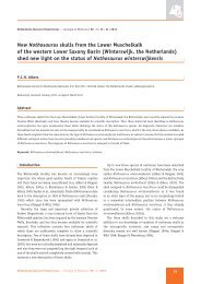
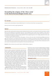
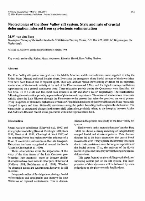
Fig. 1. The study area (indicated by <strong>the</strong> box) within its tectonic setting. Quaternary isopach lines at intervals <strong>of</strong> 100 nt (after Caston 1977;<br />
Illies 1975). (Partly after: Illies 1975 <strong>and</strong> GECO Exploration Services & Alastair Beach Associates 1989.)<br />
Structural setting<br />
Tectonic units<br />
,,,,<br />
T<br />
The <strong>Roer</strong> <strong>Valley</strong> <strong>rift</strong> <strong>system</strong> forms <strong>the</strong> main structuralphysiographic<br />
unit <strong>of</strong> <strong>the</strong> Lower Rhine Embayment.<br />
The <strong>system</strong> forms <strong>the</strong> sou<strong>the</strong>rnmost extension <strong>of</strong> <strong>the</strong><br />
North Sea Basin (Fig. 1). As such it forms part <strong>of</strong><br />
<strong>the</strong> western <strong>and</strong> central European <strong>rift</strong> <strong>system</strong>, a chain<br />
V%/,,<br />
i //,,<br />
ii // ,<br />
, i/<br />
-1 56°<br />
-1 52°<br />
- 50°<br />
-'1 48°<br />
<strong>of</strong> depocentres that connects <strong>the</strong> Mediterranean with<br />
<strong>the</strong> North Sea (Ziegler 1987). Owing to its hydrocar-'<br />
bon prospects, <strong>the</strong> geohistory <strong>of</strong> <strong>the</strong> North Sea Basin<br />
<strong>and</strong> <strong>the</strong> basin's structural setting are quite well known<br />
(Van Doorn & Leyzers Vis 1985; Van Hoorn 1987;<br />
Van Wijhe 1987; Demyttenaere 1988; GECO Exploration<br />
Services & Alaistair Beach Associates 1989;<br />
Remmelts & Duin 1990; Geluk 1990).
- - - - - - - -<br />
A<br />
Normal <strong>and</strong> strike-slip faults<br />
Stress field orientation<br />
Watershed (<strong>crustal</strong> buckling lineaments)<br />
Hercynian frontal thrust I<br />
0 0 0 30 0km<br />
i i I i<br />
0 2 4km<br />
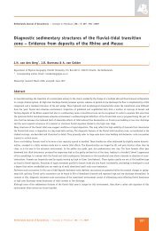
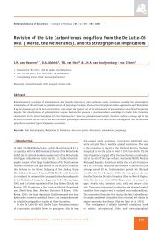
Fig. 2. Regional (palaeo) watersheds developed parallel to <strong>the</strong> Midi-Aachen Thrust in <strong>the</strong> course <strong>of</strong> <strong>the</strong> Late Neogene. They coincide with<br />
subsurface structural highs <strong>of</strong> Hercynian age <strong>and</strong> <strong>the</strong>refore are interpreted to reflect <strong>crustal</strong> buckling caused by neotectonic forel<strong>and</strong> compression.<br />
The <strong>Roer</strong> <strong>Valley</strong> <strong>rift</strong> <strong>system</strong> forms a NW-oriented<br />
fault-bounded element between <strong>the</strong> sub-parallel Upper<br />
Rhine <strong>and</strong> Central North Sea Grabens. Toge<strong>the</strong>r <strong>the</strong>se<br />
grabens form adpgleg-like structure within <strong>the</strong> extensional<br />
setting <strong>of</strong> he NW European,, -plate. The local<br />
North Sea depocentres are aligned with <strong>the</strong> ancient<br />
fault patterns at Triassic <strong>and</strong> Jurassic levels. Although<br />
145<br />
<strong>the</strong> fault expression in <strong>the</strong> Cenozoic sediments is poor,<br />
<strong>the</strong> matching between <strong>the</strong> sediment distribution <strong>and</strong> <strong>the</strong><br />
structural pattern suggests a strong control by <strong>the</strong> latter<br />
(Fig. 1).<br />
The study .area is divided into two asymmetrical<br />
segments, both having <strong>the</strong>ir deepest part along <strong>the</strong><br />
nor<strong>the</strong>ast side;
146<br />
(i) The sou<strong>the</strong>rn segment, showing <strong>the</strong> strongest subsidence,<br />
is referred to as <strong>the</strong> <strong>Roer</strong> <strong>Valley</strong> Graben<br />
(formerly named Central Graben (Remmelts &<br />
Duin 1990; Geluk 1990) or Ru(h)r Graben (Ziegler<br />
(1992)).<br />
(ii) The nor<strong>the</strong>rn segment is <strong>the</strong> Peel-Venlo Block<br />
(Van Rooijen et al. 1984), <strong>the</strong> deepest part<br />
<strong>of</strong> which is referred to as <strong>the</strong> Venlo Graben.<br />
Three NW-oriented, principal displacement zones<br />
(PDZs) bound <strong>the</strong> segments: <strong>the</strong> left-stepping<br />
S<strong>and</strong>gew<strong>and</strong>-Feldbiss-Rauw-Rijen faults in <strong>the</strong><br />
southwest; <strong>the</strong> Peel-<strong>Roer</strong> Boundary Fault forming<br />
<strong>the</strong> central element, <strong>and</strong> <strong>the</strong> Viersen Fault in <strong>the</strong>'<br />
nor<strong>the</strong>ast. To <strong>the</strong> south <strong>the</strong> area is flanked by <strong>the</strong><br />
rising South Limburg Block. The nor<strong>the</strong>rn flanking<br />
region (<strong>the</strong> Krefeld High) will not be considered.<br />
The two main segments have been faulted. These<br />
segments display subtle to strong differences in vertical<br />
movements, both expressed in <strong>the</strong> sedimentary<br />
record as well as in <strong>the</strong>ir geomorphology. Analysis <strong>of</strong><br />
<strong>the</strong>ir dynamics in space <strong>and</strong> time is important for a<br />
comprehensive view on <strong>the</strong> detailed evolution <strong>of</strong> <strong>the</strong><br />
<strong>rift</strong> <strong>system</strong> dynamics, as discussed below.<br />
State <strong>of</strong> stress<br />
The regional <strong>crustal</strong> motions are controlled by <strong>the</strong> interplay<br />
<strong>of</strong> at least three intraplate stress fields.<br />
(i) The subsiding North Sea Basin gene<strong>rate</strong>s a flexural<br />
marginal bulge. The Pleistocene highs in <strong>the</strong> sou<strong>the</strong>rn<br />
<strong>and</strong> eastern Ne<strong>the</strong>rl<strong>and</strong>s may be an expression<br />
<strong>of</strong> this bulge which forms waterdivides: to <strong>the</strong> south<br />
with <strong>the</strong> W-E running `Flemish <strong>Valley</strong>' in Belgium<br />
<strong>and</strong> to <strong>the</strong> east with <strong>the</strong> S-N running Ems valley.<br />
The PDZs dissect this bulge. The forming <strong>of</strong> a<br />
bulge may explain while fault zones in this region<br />
have a pronounced character in comparison with<br />
<strong>the</strong> poorer expressions more basinward (Fig. 1).<br />
(ii) The horizontal principal stresses in western Europe<br />
indicate deep-seated stresses away from <strong>the</strong> Alpine<br />
collision front in a northwest direction (Klein &<br />
Barr 1986; Philip 1987; Mueller et al. 1992). This<br />
stress field (Hma,) opens up <strong>the</strong> <strong>rift</strong> <strong>system</strong> by tensional<br />
forces (H,,,,i,,,) as is indicated by stress measurements<br />
(Ahorner et al. 1983; Illies & Greiner<br />
1978).<br />
(iii) The Midi-Aachen Thrust (Meissner et al. 1983)<br />
sepa<strong>rate</strong>s <strong>the</strong> study area from <strong>the</strong> Ardennes <strong>and</strong><br />
Rhenish Shield to <strong>the</strong> sou<strong>the</strong>ast. Mapping <strong>of</strong> <strong>the</strong><br />
main (palaeo-)water divides indicates a pattern <strong>of</strong><br />
alignments oriented parallel to this thrust (Fig.<br />
METHOD<br />
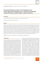
For <strong>the</strong> Over Maas, every climatic cycle <strong>of</strong> 100 ka<br />
is regist<strong>rate</strong>d as an individual terrace under a<br />
0.05< uplift <strong>rate</strong>
L- Maas terraces fan<br />
( Palaeo) Water divide W: E. Maas<br />
T' 7 Midi-Aken Thrust<br />
Section composite<br />
4 Temporal control<br />
PM palaeomagnetic boundary<br />
P pollen<br />
S soil<br />
TL <strong>the</strong>rmoluminesc2nce<br />
14C radiocarbon,<br />
West - Maas<br />
PM.P<br />
East - Maas<br />
PM<br />
P14C<br />
100 m<br />
50 m<br />
200 m<br />
150 m<br />
NW SE<br />
Not to scale<br />
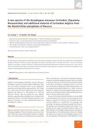
Fig. 4. Composite section <strong>of</strong> <strong>the</strong> Maas river terrace flight in South Limburg. For an indication <strong>of</strong> ages: <strong>the</strong> transition from marine terraces to<br />
fluvial (East-Maas) terraces occurred in <strong>the</strong> Mid Serravallian at about 13 Mn; <strong>the</strong> transition from East to West- Maas terraces occurred at around<br />
2.1 Ma.<br />
The first step in Fig. 3 combines <strong>the</strong>se two<br />
approaches (Veldkamp & Van den Berg 1993). This<br />
led to <strong>the</strong> conclusion that <strong>the</strong> interplay between <strong>the</strong><br />
tectonics <strong>and</strong> <strong>the</strong> macro-climatic variability (ruled by<br />
<strong>the</strong> eccentricity <strong>of</strong> <strong>the</strong> earth rotation) closely determined<br />
<strong>the</strong> long-term terrace formation <strong>and</strong> preser-<br />
PM.P<br />
TL<br />
//E<br />
320 rn<br />
250 m,<br />
I<br />
147<br />
vation. Under a tectonic uplift regime ranging from<br />
0.05 to 0.4 mm.a 1, every eccentricity-related climatic<br />
cycle is represented by a terrace in a rain-fed <strong>system</strong><br />
such as <strong>the</strong>, river Maas. Terrace sediments represent<br />
<strong>the</strong> cold periods <strong>and</strong> as such <strong>the</strong>y are valuable counterparts<br />
<strong>of</strong> <strong>the</strong> palynological record registering <strong>the</strong> warm<br />
x<br />
1<br />
d<br />
N<br />
A<br />
d<br />
A
148<br />
episodes (erosive periods). Therefore, <strong>the</strong> combined<br />
terrace <strong>and</strong> pollen record serves as a long continental<br />
climatic record.<br />
This allows <strong>the</strong> correlation <strong>of</strong> that record with <strong>the</strong><br />
deep sea oxygen isotope cl imatic record. For this correlation<br />
we used oscillation-pattern matching, supported<br />
by palaeomagnetic data. Shackleton et al. (1990)<br />
tuned <strong>the</strong> oxygen isotope record to <strong>the</strong> astronomical<br />
timescale. Thus our correlation <strong>of</strong> <strong>the</strong> marine with <strong>the</strong><br />
continental record transmits this absolute timescale to<br />
<strong>the</strong> latter record (Fig. 5). The time resolution obtained<br />
in this way reaches <strong>the</strong> 20 000 years level. This is much<br />
better than a solely biostratigraphicallybased level.<br />
In subsiding parts <strong>of</strong> <strong>the</strong> <strong>Roer</strong> <strong>Valley</strong> <strong>rift</strong>, sediment<br />
packages <strong>of</strong> different source areas interfinger or are<br />
superimposed (Edelman 1933; Zonneveld 1949; Kasse<br />
1990; Boenigk 1978). The related fluvial <strong>system</strong>s have<br />
been distinguished by means <strong>of</strong> heavy-mineral provenance<br />
studies. Their ages come from associated pollen<br />
assemblages, palaeomagnetic data <strong>and</strong> correlative terraces<br />
(Zagwijn 1960; Zagwijn et al. 1971; Zagwijn<br />
& Zonneveld 1956; Van Montfrans 1971; Zagwijn<br />
1989). The basin dynamics in space <strong>and</strong> time has<br />
been inferred from <strong>the</strong> combination <strong>of</strong> <strong>the</strong> morpho-<br />
(litho)strati graphic model with <strong>the</strong> time frame within<br />
<strong>the</strong> given tectonic framework. We used <strong>the</strong> terraces<br />
in uplifting parts (time-altitude position). In <strong>the</strong> subsiding<br />
part we used map-pattern correlation <strong>of</strong> <strong>the</strong><br />
changing fluvial pathways (palaeogeography) with <strong>the</strong><br />
known structural units.<br />
Regional Late Miocene emergence<br />
The study area slowly changed from a shallow marine<br />
environment to a fluvial plain since <strong>the</strong> Mid-Miocene,<br />
around 13 Ma (Quitzow 1974; Zagwijn & Hager 1987;<br />
Zagwijn 1989). This regressive coastal plain is bounded<br />
in <strong>the</strong> sou<strong>the</strong>ast by a palaeo-coastline . This line<br />
is ei<strong>the</strong>r marked as a sub-aerial, low fossil cliff with<br />
residual beach-pebbles (Van den Berg 1989, Felder &<br />
Bosch 1989, De Jong & Van der Waals 1971), or as a<br />
buried beach (Hager 1981; Boersma 1992). The cliff<br />
forms an important morpho-stratigraphic marker in <strong>the</strong><br />
regional uplift history, because <strong>the</strong> onset <strong>of</strong> <strong>the</strong> regression<br />
is well correlated with Vail's cycle boundary TB<br />
2.4/2.5 (13 Ma; Herngreen 1987)<br />
The emerging coastal plain was fed by three feeder<br />
<strong>system</strong>s: <strong>the</strong> (Early-)Rhine, <strong>the</strong> Maas, <strong>and</strong> a number<br />
<strong>of</strong> relatively small `Belgian' streams draining <strong>the</strong><br />
north flank <strong>of</strong> <strong>the</strong> Brabant Massif. The uplifting south<br />
flank <strong>of</strong> <strong>the</strong> <strong>rift</strong> <strong>system</strong> toge<strong>the</strong>r with <strong>the</strong> Ardennes-<br />
Rhenish Shield were important sediment suppliers. Net<br />
upstream erosion leaves a terrace flight. The erosion<br />
record <strong>of</strong> <strong>the</strong> Maas <strong>system</strong> is <strong>the</strong> longest <strong>and</strong> best dated<br />
<strong>of</strong> <strong>the</strong> three <strong>and</strong> can be used sepa<strong>rate</strong>ly to reconstruct<br />
<strong>the</strong> uplift history <strong>of</strong> <strong>the</strong> sou<strong>the</strong>ast flank <strong>of</strong> <strong>the</strong> <strong>system</strong>.<br />
This record will be discussed first, followed by<br />
a discussion focusing on <strong>the</strong> sedimentation area: <strong>the</strong><br />
subsiding grabens.<br />
Uplift <strong>of</strong> <strong>the</strong> south flank region<br />
The record<br />
In <strong>the</strong> sou<strong>the</strong>ast part <strong>of</strong> <strong>the</strong> area, below <strong>the</strong> last Mid-<br />
Miocene marine cliff a flight <strong>of</strong> 30 fluvial terraces has<br />
been formed (Fig.4). The flight is spread in a terraced<br />
`fan'. Its formation is strongly tectonically controlled<br />
in space <strong>and</strong> time. In mapview <strong>the</strong> `fan' is divided by<br />
two buckling lineaments parallel to <strong>the</strong> Midi-Aachen<br />
Thrust (Fig. 2); <strong>the</strong> sou<strong>the</strong>rnmost lineament sepa<strong>rate</strong>s<br />
<strong>the</strong> (palaeo) East-Maas from <strong>the</strong> (present) West-Maas,<br />
<strong>the</strong> o<strong>the</strong>r one sepa<strong>rate</strong>s <strong>the</strong> Main Terrace group from<br />
<strong>the</strong> Middle Terrace group. The `fan' is bounded to<br />
<strong>the</strong> west by a series <strong>of</strong> along-strike overstepping faults<br />
(<strong>the</strong> Rauw, Hooge Mierde <strong>and</strong> Rijen faults). The time<br />
is expressed by <strong>the</strong> height difference between <strong>the</strong> individual<br />
terrace steps. The vertical distance between <strong>the</strong><br />
last marine cliff (age about 13 Ma) <strong>and</strong> <strong>the</strong> first Maas<br />
terrace, that witnesses cold-climate conditions <strong>of</strong> <strong>the</strong><br />
Latest Pliocene to earliest Pleistocene (age about 2.7-<br />
2.4 Ma), amounts to only 30 m. This distance is bridged<br />
by three terrace levels <strong>of</strong> late Tertiary age. The 30 m<br />
corresponds to an average uplift <strong>rate</strong> <strong>of</strong> around 3. 10-6<br />
m.a- 1. On <strong>the</strong> o<strong>the</strong>r h<strong>and</strong> <strong>the</strong> remaining Pleistocene<br />
through Holocene record covers 160 m, giving an average<br />
uplift <strong>rate</strong> <strong>of</strong> 6.10-5 m.a 1. The major difference<br />
between <strong>the</strong>se two long-term averages in uplift <strong>rate</strong>s,<br />
in conjunction with <strong>the</strong> results obtained from <strong>the</strong> subsidence<br />
analysis published elsewhere (Zijerveld et al.<br />
1992), highlights <strong>the</strong> importance <strong>of</strong> <strong>the</strong> discontinuity<br />
in <strong>the</strong> <strong>rate</strong>s <strong>of</strong> <strong>the</strong> vertical motions. This break may be<br />
used to define more precisely <strong>the</strong> timing <strong>of</strong> <strong>the</strong> onset<br />
<strong>of</strong> <strong>the</strong> regional neotectonics (Fig. 5).<br />
Figure 6 shows in more detail <strong>the</strong> regional neotectonic<br />
uplift record. The record is based on <strong>the</strong> height<br />
<strong>and</strong> age <strong>of</strong> various individual fluvial terrace surfaces.<br />
These surfaces have been reconstructed by finding<br />
best-fit plains through <strong>the</strong> tops <strong>of</strong> <strong>the</strong> respective fluvial<br />
sediments (Van den Berg 1989). In this way we were
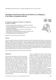
15 12 9<br />
Time (Ma)<br />
I I 1 I I I 1 I I<br />
Pollenrecord in <strong>the</strong> <strong>Roer</strong> <strong>Valley</strong> Graben<br />
(Zagwijn <strong>and</strong> Hager 1987)<br />
} Time position controlled by: absolute dating (T.L.), pollen<br />
I <strong>and</strong>/or paleomagnetism<br />
Time position probable by modelling<br />
Time position tentative<br />
? Terrace expected but not found<br />
Fluvial terrace level<br />
Composite climatic variability <strong>of</strong> <strong>the</strong> Late Cenozoic<br />
Trend <strong>of</strong> uplift<br />
CRUSTALACTIVITY IN THE BOER VALLEY GRABEN<br />
Strike slip movement<br />
Inversion<br />
Volcanism East Eifel<br />
Onset <strong>of</strong> fluvial activity<br />
following cycle boundary<br />
TB 2.4/2.5<br />
Serravailian Tortonian Ii<br />
MIOCENE<br />
8eOO.D.P653 .................................................<br />
aAO-O.D.P.677 '<br />
(Thunell et.al. 1996) (Shackleton etal. 1991)<br />
Messinian<br />
I<br />
PLIOCENE<br />
PLEISTOCENE<br />
Fig. 5. Miocene to recent uplift record at <strong>the</strong> sou<strong>the</strong>rn shoulder <strong>of</strong> <strong>the</strong> <strong>Roer</strong> <strong>Valley</strong> Graben from dating <strong>of</strong> <strong>the</strong> terrace flight in Fig. 4. The major<br />
break in <strong>the</strong> uplift witnesses <strong>the</strong> onset <strong>of</strong> <strong>the</strong> regional neotectonics at around 3 Ma.<br />
able to ignore <strong>the</strong> effects <strong>of</strong> post-depositional erosion<br />
or accumulation affecting <strong>the</strong>. height <strong>of</strong> <strong>the</strong> terraces.<br />
The obtained accuracy is estimated to be in <strong>the</strong> order<br />
<strong>of</strong> about +/- 1 m.<br />
The positions <strong>of</strong> <strong>the</strong> reconstructed terrace surfaces<br />
on, <strong>the</strong> time axis were chosen at <strong>the</strong> very end <strong>of</strong> glacial<br />
periods around <strong>the</strong> transition to. <strong>the</strong> next interglacial.<br />
Due to this climatic shift, floodplain aggradation is<br />
replaced by a rapid fluvial incision into <strong>the</strong> old floodplain<br />
(Van den Berg 1993). This is <strong>the</strong> response to an<br />
important change in <strong>the</strong> bedload/discharge ratio. Such<br />
a cold-warm shift lasts only a few thous<strong>and</strong> years. So<br />
149<br />
within <strong>the</strong> scale proportions <strong>of</strong> Fig. 6, time-error bars<br />
can not be indicated.<br />
Interpretation<br />
The Pleistocene terrace record shows some clear departures<br />
from <strong>the</strong> average uplift <strong>rate</strong> <strong>of</strong> 0.06 mm.a t .<br />
These are interpreted to reflect <strong>the</strong> waxing <strong>and</strong> waning<br />
<strong>of</strong> <strong>the</strong> regional stress field. The most important reactivation<br />
occurred between 3 <strong>and</strong> 2.7 Ma, a second one<br />
around 1 Ma, <strong>and</strong> a third one just after 500 ka BP.<br />
Precision levelling indicates that <strong>the</strong> area is presently
150<br />
POLLEN<br />
STAGES<br />
P. M.<br />
CLIMATE<br />
(ODP 677)<br />
PLIOCENE<br />
Cool<br />
Warm<br />
REUVERIAN P.T.<br />
Top Maas Terraces<br />
Temporal control<br />
O Palaeo magnetism<br />
TL Thermoluminescence<br />
S Soil<br />
P Pollen<br />
"C Radiocarbon<br />
Relaxation Intervals<br />
El<br />
A<br />
TIGLIAN<br />
B C1.4 5-6<br />
P.M.Cool Warm Pollen stages<br />
v<br />
o<br />
o<br />
Weichselien<br />
Saalien<br />
',_Elsterien<br />
Cromerien<br />
Bavelien<br />
Menapien<br />
Waalien<br />
Eburonien<br />
Tiglien<br />
Pre-Tiglien<br />
Reuverien<br />
Brunssumien<br />
<strong>Roer</strong> valley graben Peel high Venlo low<br />
\R+M<br />
R+<br />
N<br />
oa<br />
76<br />
N<br />
U<br />
Krefeld high Rhine valley<br />
R Rhine sediments<br />
M Maas sediments<br />
B Belgian-river sediments<br />
F Shifting positions<br />
- <strong>of</strong> <strong>the</strong> Rhine<br />
Fig. 7. Stratigraphic chart showing <strong>the</strong> sedimentary infill <strong>of</strong> <strong>the</strong> <strong>Roer</strong> <strong>Valley</strong> <strong>rift</strong> <strong>system</strong> by <strong>the</strong> Plio-Pleistocene Rhine, Maas <strong>and</strong> Belgian<br />
rivers. Indicated by arrows is <strong>the</strong> shifting position <strong>of</strong> <strong>the</strong> Rhine (<strong>and</strong> Maas) across <strong>the</strong> principal displacement zones (PDZ). This behaviour is<br />
tectonically controlled by strike-slip motion along <strong>the</strong> central PDZ; see also Fig. 8a-c. (Sediment record compiled partly after Zagwijn 1960;<br />
Van der Toorn 1967; Bisschops 1973; Bisschops et al. 1982; Zagwijn & De Jong 1983).<br />
shift <strong>of</strong> <strong>the</strong> Rhine (Fig. 8a-c). This level was selected<br />
because it lies at relatively shallow depth in <strong>the</strong><br />
graben <strong>and</strong> its palaeogeography is controlled by many<br />
borings.<br />
Rhine sediments show a characteristic mineral<br />
zoning over time (Zonneveld 1949). The youngest<br />
Rhine sediments in <strong>the</strong> graben are characterised by<br />
<strong>the</strong> `Weert' mineral zone. The areal distribution <strong>of</strong> this<br />
mineralogy (Fig. 8a) shows that <strong>the</strong> <strong>system</strong> occupied a<br />
wide depositional plain with a mid-graben area <strong>of</strong> nondeposition.<br />
The river Maas formed a tributary river.<br />
In -<strong>the</strong> course <strong>of</strong> <strong>the</strong> next cold stage, <strong>the</strong> Rhine sediments<br />
disappear from <strong>the</strong> graben <strong>and</strong> only Maas sediments<br />
(<strong>the</strong> Rosmalen mineral zone; Zonneveld 1964)<br />
are found in apattern that is strongly confined by faults<br />
in <strong>the</strong> middle part <strong>of</strong> <strong>the</strong> central PDZ where <strong>the</strong>re is a<br />
strong curvature on' its fault trace (Fig. 8b).<br />
Interpretation<br />
Palaeogeography<br />
If we assume right-lateral strike-slip motion along <strong>the</strong><br />
central PDZ, deformation adjacent to this zone relies<br />
on its shape (Christie-Blick& Biddle 1985). The major<br />
bends in <strong>the</strong> fault trace ei<strong>the</strong>r act as a releasing or as a<br />
restraining bend. The first opens up a local pull apart<br />
basin (confining <strong>the</strong> Maas floodplain), while <strong>the</strong> latter<br />
simultaneously forces <strong>the</strong> encompassed block (<strong>the</strong><br />
Erft Block) to emerge. As this block is tilted towards<br />
<strong>the</strong> nor<strong>the</strong>ast, <strong>the</strong> river Rhine is forced into that direction.<br />
To meet <strong>the</strong> optimal angular relationships between<br />
stress orientation <strong>and</strong> <strong>the</strong> fault line in a strike-slip setting,<br />
an additional stress component is required as<br />
normal faulting dominates <strong>the</strong> regional structural style
152<br />
a. Palaeo geography during stage: 19 (1+2) <strong>and</strong> stage: 18-16 (2)<br />
ROER VALLEY ............... GRABEN<br />
BELGIUM<br />
Stress field condition: Tension N 50°E prevails<br />
--- Maas + Subsidence following extension<br />
........ 01 Rhine t Uplift following compression<br />
C.<br />
ROER VALLEY GRABEN<br />
b. Palaeo geography during stage: 16 + 15<br />
BELGIUM<br />
N 320°E compression dominates over N WE tension giving rise to strikeslip<br />
motion along <strong>the</strong> central PDZ (see c.)<br />
GERMANY<br />
GERMANY<br />
0 10 20 30 40km<br />
Fig. 8. Palaeogeographic evolution around 700 ka BP showing <strong>the</strong> last eastward shift <strong>of</strong> <strong>the</strong> Rhine. The present-day course <strong>of</strong> <strong>the</strong> Maas is shown<br />
for orientation purposes. a) Over <strong>the</strong> period equivalent to deep sea stages 19 through 16, normal faulting <strong>and</strong> tension dominates in <strong>the</strong> <strong>Roer</strong><br />
<strong>Valley</strong> Graben. b) In <strong>the</strong> course <strong>of</strong> stage 16, transtensional <strong>and</strong> transpressive movements along <strong>the</strong> central principal displacement zone (PDZ)<br />
cause a palaeo-geographic reorganisation in <strong>and</strong> separation <strong>of</strong> <strong>the</strong> positions <strong>of</strong> <strong>the</strong> Rhine <strong>and</strong> Maas floodplains by uplift <strong>and</strong> tilting towards <strong>the</strong><br />
nor<strong>the</strong>ast <strong>of</strong> <strong>the</strong> Erft Block. c) The change from normal faulting to strike-slip faulting along <strong>the</strong> central PDZ is interpreted to result from an<br />
increase in forel<strong>and</strong> compression by <strong>the</strong> Ardennes Massif along <strong>the</strong> reactivated Midi-Aachen Thrust.
Rotation<br />
-0-- Fold axis<br />
Shear fault-axis<br />
Normal fault-axis<br />
Fig. 9. Morphologically identified lineaments in <strong>the</strong> study area formed since around 600 ka represented in a rose diagram (orientation class x<br />
cumulative-length percentage, after: Van den Berg et al. 1994). The diagram is consistent with a right-lateral rotation following <strong>the</strong> horizontal<br />
stress components Hmax N150-160° E <strong>and</strong> H,,,i, N50-65° E.<br />
(Fig. 8c). It is suggested that <strong>the</strong> interplay between <strong>the</strong><br />
regional SW-NE oriented tension <strong>and</strong> <strong>the</strong> NW-oriented<br />
compression gene<strong>rate</strong>d by <strong>the</strong> Ardennes (see above)<br />
periodically may lead to such optimal conditions (Fig.<br />
8c).<br />
Temporarily active depocentres along <strong>the</strong> three<br />
principal displacement zones are assumed to be likewise<br />
indicative for periods when <strong>the</strong> Ardennes stress<br />
field overrules <strong>the</strong> general tension. For example, within<br />
<strong>the</strong> Voorne Trough, adepocentre arranged along <strong>the</strong><br />
`a<br />
Hmax<br />
R<br />
W<br />
N<br />
X<br />
f<br />
Hmin<br />
153<br />
sou<strong>the</strong>rn PDZ, about 200 m-thick deltaic deposits <strong>of</strong><br />
Pre-Tiglian age are encountered. The Pre-Tiglian lasted<br />
only 100 000 years <strong>and</strong> represents a cold stage with<br />
low sea-levels. The unusually thick <strong>and</strong> lithologically<br />
uniform deposits suggest <strong>the</strong>refore an extremely high<br />
accomodation <strong>rate</strong> in <strong>the</strong> marginal trough during this<br />
time interval. This is consistent with <strong>the</strong> coeval strong<br />
reactivation <strong>of</strong> <strong>the</strong> uplift <strong>of</strong> <strong>the</strong> Ardennes as registered<br />
by <strong>the</strong> Maas river terrace record. Along <strong>the</strong> nor<strong>the</strong>rn<br />
PDZ (<strong>the</strong> Viersen Fault), periodic preservation in <strong>the</strong>
154<br />
Venlo marginal graben also indicates periods with local<br />
extension in <strong>the</strong> releasing bend. Such simultaneously<br />
operating processes in basin extension <strong>and</strong> flank uplift<br />
are important markers in <strong>the</strong> neotectonic evolution <strong>of</strong><br />
<strong>the</strong> stress regime.<br />
Stress-controlled geomorphology<br />
In Fig. 8a, <strong>the</strong> floodplain splits around a mid-graben<br />
non-deposition area within <strong>the</strong> graben. This floodplain<br />
separation is interpreted to represent a mid-graben relative<br />
high, bounded by flanking lows, In <strong>the</strong> <strong>Roer</strong>mond<br />
area, <strong>the</strong> <strong>Roer</strong> <strong>Valley</strong> Graben is also morphologically<br />
characterised by a persistent central high (with terraces<br />
= uplift) <strong>and</strong> two flanking fault-bounded lows.<br />
Both from <strong>the</strong> seismic lines <strong>and</strong> from <strong>the</strong> morphology<br />
we know that such a tectonic low in itself repeats<br />
such a relief pattern. This tectonically defined morphology<br />
shows a sequence <strong>of</strong> scales: <strong>the</strong> fractal-alike<br />
pattern that emerges shows a strong similarity with <strong>the</strong><br />
stress-responding differential flexural <strong>crustal</strong> motions<br />
at basin-wide scales in a tensional setting (Cloetingh et<br />
al. 1985). This sequence may suggest that <strong>the</strong> <strong>crustal</strong><br />
mechanics <strong>of</strong> a divergent strike-slip setting ope<strong>rate</strong> at<br />
a local, a regional <strong>and</strong> a basin-wide scale. The scale<br />
determines <strong>the</strong> nature <strong>of</strong> <strong>the</strong> bounding structures: faults<br />
or flexures.<br />
Shortly after <strong>the</strong> Rhine shifted to <strong>the</strong> east, <strong>the</strong> Maas<br />
also shifted out <strong>of</strong> <strong>the</strong> graben <strong>and</strong> slipped <strong>of</strong>f <strong>the</strong> tilted<br />
Peel Block towards its present position. The presentday<br />
surface <strong>of</strong> this series <strong>of</strong> ab<strong>and</strong>oned floodplains<br />
shows a well-defined deformation pattern, expressed<br />
as a low relief (1 to 2 m scale) <strong>of</strong> structural lineaments<br />
(Van den Berg et al. 1994). Figure 9 shows <strong>the</strong> rosediagram<br />
(cumulative length x orientation-class) <strong>of</strong> <strong>the</strong><br />
lineaments in <strong>the</strong> area. The orientations are consistent<br />
with <strong>the</strong> results obtained in an area east <strong>of</strong> <strong>the</strong> Viersen<br />
Fault (Plein et al. 1982).<br />
In accordance with <strong>the</strong> palaeogeography, <strong>the</strong> geomorphology<br />
indicates <strong>the</strong> ongoing right-lateral divergent<br />
strike-slip faulting due to block rotation over <strong>the</strong><br />
last 600 ka. This is <strong>the</strong> most recent pulse in a series.<br />
Plate-tectonic implications <strong>and</strong> discussion<br />
We identified a number <strong>of</strong> accelerations <strong>and</strong> decelerations<br />
(pulses) superimposed on a generally high-<strong>rate</strong><br />
tectonic phase since <strong>the</strong> last 3 Ma. There are indications<br />
from o<strong>the</strong>r parts <strong>of</strong> Europe that important physiographic<br />
changes tend to cluster around <strong>the</strong>se pulses.<br />
For example, near <strong>the</strong> Gauss-Matuyama magnetoboundary<br />
a thrusting pulse <strong>of</strong> <strong>the</strong> Jura mountains causes<br />
<strong>the</strong> connection <strong>of</strong> <strong>the</strong> Upper Rhine with <strong>the</strong> Swiss Alps.<br />
This has been identified in <strong>the</strong> heavy-mineral composition<br />
<strong>of</strong> <strong>the</strong> Rhine sediments (Boenigk 1982; Tebbens<br />
et al. 1995).<br />
The Alpine geodynamics are thought to be <strong>the</strong><br />
mechanical consequence <strong>of</strong> <strong>the</strong> Africa-Europe collision.<br />
The presence <strong>of</strong> intra-plate stresses provides<br />
a possibility to underst<strong>and</strong> a coupling between <strong>the</strong><br />
inter-plate dynamics <strong>of</strong> <strong>the</strong> two plates <strong>and</strong> <strong>the</strong> pulses<br />
observed in our study area. It is suggested here that <strong>the</strong><br />
relaxation interval between 1.5-1.2 Ma (Fig. 6) may<br />
be <strong>the</strong> consequence <strong>of</strong> an observed change in direction<br />
<strong>of</strong> <strong>the</strong> relative motion <strong>of</strong> <strong>the</strong> African plate. During a<br />
part <strong>of</strong> <strong>the</strong> Early Pleistocene this direction temporarily<br />
changed from northwest towards nor<strong>the</strong>ast; this is<br />
extensively studied in <strong>the</strong> Tyrrhenian arc <strong>system</strong> by<br />
e.g. Van Dijk & Scheepers (1994) <strong>and</strong> summarised<br />
by Scheepers (1994). From <strong>the</strong> same area Brogan et<br />
al.(1975) report a pr<strong>of</strong>ound change in <strong>the</strong> activity <strong>of</strong><br />
<strong>the</strong> Tyrrhenian arc about 1.1 Ma.<br />
Contemporaneously with this last event, uplift<br />
<strong>and</strong> consequent terrace formation begin in <strong>the</strong> central<br />
Appenines, Italy (Coltorti 1993), <strong>the</strong> Limagne, France<br />
(Allier river, Veldkamp 1991), on <strong>the</strong> north flank <strong>of</strong><br />
<strong>the</strong> Paris Basin (Somme river, Antoine 1993), <strong>and</strong> in<br />
<strong>the</strong> Bohemian Massif (W.H. Zagwijn, pers. comm.<br />
1993).<br />
The relaxation phase found between 600 <strong>and</strong> 430 ka<br />
shows a strong synchronism with phase 2 <strong>of</strong> <strong>the</strong> Eastern<br />
Eifel volcanic activity (Van den Bogaard & Schmincke<br />
1990). The o<strong>the</strong>r recognised phases in <strong>the</strong> Eastern<br />
Eifel volcanism are relatively short with respect to <strong>the</strong><br />
resolution <strong>of</strong> <strong>the</strong> changes in uplift <strong>rate</strong> registered by<br />
<strong>the</strong> Maas river record, although <strong>the</strong>re is synchronism<br />
between <strong>the</strong> last recorded relaxation phase <strong>and</strong> phase<br />
5 in <strong>the</strong> volcanic activity.<br />
Although this list <strong>of</strong> records is far from <strong>system</strong>atic<br />
<strong>and</strong> complete, <strong>the</strong>y suggest that <strong>the</strong> Maas terrace<br />
flight identifies a lithospheric signal <strong>of</strong> plate-tectonic<br />
importance.<br />
The coincidence <strong>of</strong> regional uplift <strong>of</strong> ancient structural<br />
domes <strong>and</strong> sinking basins, toge<strong>the</strong>r with <strong>the</strong> formation<br />
<strong>of</strong> pull-apart basins due to divergent strike-slip<br />
motions in response to forel<strong>and</strong> compression by <strong>the</strong><br />
Alps <strong>and</strong> <strong>the</strong> Rhenish Shield, may suggest that <strong>the</strong>se<br />
processes are controlled by important phases in <strong>the</strong><br />
plate reorganisation (Cloetingh & Kooi 1992).<br />
The observed accelerations in uplift from <strong>the</strong> Tertiary<br />
to <strong>the</strong> Pleistocene, in conjunction with <strong>the</strong> accel-
eration <strong>of</strong> global volcanism throughout <strong>the</strong> Quaternary<br />
(Kennet & Thunell 1975) <strong>and</strong> <strong>the</strong> present-day<br />
high velocities <strong>of</strong> <strong>crustal</strong> movements with respect to<br />
<strong>the</strong> Pleistocene long-term average, raise <strong>the</strong> intriguing<br />
question: Do we live at present in a period <strong>of</strong> extreme<br />
<strong>crustal</strong> dynamics?<br />
Acknowledgements<br />
This paper is published with <strong>the</strong> permission <strong>of</strong> <strong>the</strong><br />
Director <strong>of</strong> <strong>the</strong> Geological Survey <strong>of</strong> <strong>the</strong> Ne<strong>the</strong>rl<strong>and</strong>s.<br />
The Graphic-Design section <strong>of</strong> <strong>the</strong> DLO-Win<strong>and</strong> Staring<br />
Centre skillfully prepared <strong>the</strong> drawings. The author<br />
wishes to thank Pr<strong>of</strong>. Dr. Salomon Kroonenberg<br />
for his helpful comments on an early draft <strong>of</strong> <strong>the</strong><br />
manuscript.<br />
References<br />
Ahorner, L., B. Baier & K.P. Bonjer 1983 General pattern <strong>of</strong> seismotectonic<br />
dislocation <strong>and</strong> earthquake-generating stress field in<br />
Central Europe between <strong>the</strong> Alps <strong>and</strong> <strong>the</strong> North Sea. In: K. Fuchs,<br />
H. von Gehlen, H. Malzer, H. Murawski & A. Sentinel (eds),<br />
Plateau Uplift. The Rhenish Shield - A Case History. Springer,<br />
Berlin: 187-197<br />
Antoine, P. 1993 The cyclic morpho-sedimentary evolution <strong>of</strong> <strong>the</strong><br />
Somme valley: An original answering model to <strong>the</strong> Quaternary<br />
climatic variations since about 800,000 - Abstr. Ear. Union <strong>of</strong><br />
Geologists VII Congress, Strasbourg<br />
Bisschops, J.H. 1973 Toelichtingen bij de Geologische kaart van<br />
Nederl<strong>and</strong>, 1:50.000. Blad Eindhoven Oost (51 O), Rijks Geol.<br />
Dienst, Haarlem. 132 pp<br />
Bisschops, J.H., J.P. Broertjes & W. Dobma 1982 Toelichtingen bij<br />
de Geologische Kaart van Nederl<strong>and</strong>, 1:50.000..Blad Eindhoven<br />
West (51 W), Rijks Geol. Dienst, Haarlem. 216 pp<br />
Boenigk, W. 1978 Gliederung der altquartaren Ablagerungen in der<br />
Niederrheinischen Bucht - Fortschr. Geol. Rheinl. Westf. 28:135-<br />
212<br />
Boenigk, W. 1982 Der Einfluss des Rheingraben-Systems auf die<br />
Fluszgeschichte des Rheins - Z. Geomorph. N.F., Suppl. Bd. 42:<br />
167-175<br />
Boersma, J.R. 1992 A large flood-tidal delta <strong>and</strong> its successive<br />
spill-over aprons: detailed proximal-distal facies relationships.<br />
(Miocene Lignite Suite, lower Rhine Embayment Germany). In:<br />
D.G. Smith, B.A. Zaitlin & R.A. Rahmani (eds) Clastic tidal<br />
sedimentology, Can. Soc. Petrol. Geol. Mem. 16: 227-254<br />
Brogan, G.E., L.S. Cluff & L.C. Taylor 1975 Seismicity <strong>and</strong> uplift<br />
<strong>of</strong> sou<strong>the</strong>rn Italy. In: N. Pavoni & R. Green (eds), Recent Crustal<br />
Movements - Tectonophysics 29: 323-330<br />
Caston, V.N.D. 1977 A new isopachyte map <strong>of</strong> <strong>the</strong> Quaternary <strong>of</strong> <strong>the</strong><br />
North Sea, In: Quaternary sediments <strong>of</strong> <strong>the</strong> Central North Sea 1<br />
<strong>and</strong> 1, Rep. Inst. Geol. Sci. London 77/11: 1-8<br />
Christie-Blick, N. & K.T, Biddle 1985 Deformation <strong>and</strong> basin formation<br />
along strike-slip faults. In: K.T. Biddle & N. Christie-Blick<br />
(eds) Strike-Slip Deformation, Basin Formation, <strong>and</strong> Sedimentation<br />
- Soc. Econ. Paleont. Mineral. Spec. Publ. 37: 1-34<br />
155<br />
Cloetingh, S. & H. Kooi 1992 Tectonic subsidence <strong>and</strong> global change<br />
- inferences from late Cenozoic subsidence <strong>and</strong> uplift patterns in<br />
<strong>the</strong> Atlantic/Mediterranean region - Terra Nova 4: 340-350<br />
Cloetingh, S., H. McQueen & K. Lambeck 1985 On a tectonic<br />
mechanism for regional sealevel variations - Earth Plan. Sci. Lett.<br />
75: 157-166<br />
Cloetingh, S., EM. Gradstein, H. Kooi, A.C. Grant & M. Kaminski<br />
1990 Plate reorganisation: a cause <strong>of</strong> rapid late Neogene subsidence<br />
around <strong>the</strong> North Atlantic? - J. Geol. Soc. Load. 147:<br />
459-506a<br />
Coltorti, M. 1993 River evolution in <strong>the</strong> Umbria-Marchi Apenines<br />
during <strong>the</strong> Pleistocene. Abstr. Ear. Union <strong>of</strong> Geologists VII<br />
Congress, Strasbourg<br />
De Jong, J.D. & L. van der Waals 1971 Depositional environment <strong>and</strong><br />
wea<strong>the</strong>ring phenomena <strong>of</strong> <strong>the</strong> white Miocene s<strong>and</strong>s <strong>of</strong> sou<strong>the</strong>rn<br />
Limburg (The Ne<strong>the</strong>rl<strong>and</strong>s) - Geol. Mijnbouw 50: 417-424<br />
Demyttenaere, R. 1988 De Post-Paleozoische geschiedenis van<br />
Noord-Belgie, PhD-Thesis, Kath. Univ. Leuven, 175 pp<br />
Edelman, C.H. 1933 Petrologische provincies in her Nederl<strong>and</strong>se<br />
Kwartair. PhD-Thesis, Amsterdam, 103 pp<br />
Felder, W.M. & P.B. Bosch 1989 Geologische kaart van Zuid-<br />
Limburg en omgeving, schaal 1: 50 000. Afzettingen van de<br />
Maas. Rijks Geol. Dienst. Heerlen<br />
GECO Exploration Services & Alastair Beach Associates 1989 Tectonic<br />
map <strong>of</strong> <strong>the</strong> North sea <strong>and</strong> adjacent onshore areas. GECO<br />
Mapping <strong>and</strong> Graphics Department, Orpington, Kent<br />
Geluk, M. 1990 The Cenozoic <strong>Roer</strong> <strong>Valley</strong> Graben, Sou<strong>the</strong>rn Ne<strong>the</strong>rl<strong>and</strong>s<br />
- Meded. Rijks Geol. Dienst 44-4: 65-72<br />
Groenewoud, W., G.K. Lorenz, F.J.J. Brouwer & R.J. Molendijk<br />
1991 Geodetic determination <strong>of</strong> recent l<strong>and</strong>subsidence in The<br />
Ne<strong>the</strong>rl<strong>and</strong>s, L<strong>and</strong> subsidence (proc. Fourth Intern. Symp. on<br />
L<strong>and</strong> Subsidence). Int. A HS Publ. no. 200<br />
Hager, H. 1981 Das Tertiar des Rheinischen Braunkohlen Reviers.<br />
Ergebnisse <strong>and</strong> Probleme - Fortschr. Geol. Rheinl. Westf. 29:<br />
529-563<br />
Herngreen, G.F.W. 1987 Correlation between <strong>the</strong> Miocene beds in<br />
<strong>the</strong> SE Ne<strong>the</strong>rl<strong>and</strong>s <strong>and</strong> Italy based on din<strong>of</strong>lagellate biozonation<br />
- Meded. Werkgr. Kwart. en Ten. Geol. 24: 31-40<br />
Illies, J.H. 1975 Recent <strong>and</strong> paleo-intraplate tectonics in stable<br />
Europe <strong>and</strong> <strong>the</strong> Rhinegraben <strong>rift</strong> <strong>system</strong> - Tectonophysics 29:<br />
251-264<br />
Illies, J.H. & G. Greiner 1978 Rhine graben <strong>and</strong> <strong>the</strong> Alpine <strong>system</strong><br />
- Geol. Soc. Am. Bull. 89: 770-782<br />
Kalvoda, J. 1988 Recent orogeny <strong>of</strong> <strong>the</strong> Himalayas - A remarkable<br />
geomorphological event - Journ. Geodynamics 9; 319-329<br />
Kasse, C. 1990 Lithostratigraphy <strong>and</strong> provenance <strong>of</strong> Early-<br />
Pleistocene deposits in <strong>the</strong> Sou<strong>the</strong>rn Ne<strong>the</strong>rl<strong>and</strong>s <strong>and</strong> Nor<strong>the</strong>rn<br />
Belgium - Geol. Mijnbouw 69: 327-340<br />
Kennett, J.P. & R.C. Thunell 1975 Global increase in Quaternary<br />
explosive volcanism. - Science 187: 497-503<br />
Klein, R.J., & M.V. Barr 1986 Regional state <strong>of</strong> stress in western<br />
Europe. In: O.Stephenson (ed.), Rock stress <strong>and</strong> stress measurements,<br />
Centek, Lulea: 33-44<br />
Kooi,.H., 1991 Tectonic modelling <strong>of</strong> extensional basins. The role <strong>of</strong><br />
lithospheric flexure, intraplate stress <strong>and</strong> sealevel change. PhD-<br />
Thesis, Vrije Universiteit, Amsterdam, 181 pp<br />
Kooi, H. & S. Cloetingh 1989 Intraplate stresses <strong>and</strong> <strong>the</strong> tectonostratigraphic<br />
evolution <strong>of</strong> <strong>the</strong> Central North Sea - Am. Assoc.<br />
Petr. Geol. Mem. 46: 541-558<br />
Kooi, H., H. Hettema & S. Cloetingh 1991 Lithospheric dynamics<br />
<strong>and</strong> <strong>the</strong> rapid Plio-Quaternary subsidence phase in <strong>the</strong> sou<strong>the</strong>rn<br />
North Sea basin - Tectonophysics 192: 245-259<br />
Lorenz, G.K., W. Groenwoud, F. Schokking, M.W. van den Berg,<br />
J. Wiersma, F.J.J. Brouwer & S. Jelgersma 1991 Interim-rapport
156<br />
over her onderzoek naar de bodembeweging in Nederl<strong>and</strong>. Rijkswaterstaat,<br />
Delft/Rijswijk, Rijks Geol. Dienst, Haarlem, 75 pp<br />
Malzer, H., G. Hein & K. Zippelt 1983 Height changes in <strong>the</strong> Rhenish<br />
Massif: determination <strong>and</strong> analysis. In: K. Fuchs, K. von Gehlen,<br />
H. Malzer, H. Murawski & H. Semmel (eds), Plateau Uplift - The<br />
Rhenish Shield - A Case History. Springer, Berlin: 260-275<br />
Meissner, R., N. Springer, H. Murawski, H. Bartelsen, E.R. Flub<br />
& H. Durschner 1983 Combined seismic reflection-refraction<br />
investigations in <strong>the</strong> Rhenish Massif <strong>and</strong> <strong>the</strong>ir relation to recent<br />
tectonic movements. In: K. Fuchs et al. (eds), Plateau uplift - The<br />
Rhenish Shield - A Case History. Springer, Berlin: 276-287<br />
Mueller, B., M.L. Zoback, FFuchs, L.Mastin, S.Gregersen, N.<br />
Pavoni, O. Stephansson & C. Ljunggren 1992 Regional patterns<br />
<strong>of</strong> tectonic stress in Europe - J. Geophys. Res. 97 B8: 11,783-<br />
11,803<br />
Philip, H. 1987 Plio-Quaternary evolution <strong>of</strong> <strong>the</strong> stress field in <strong>the</strong><br />
Mediterranean zones <strong>of</strong> subduction <strong>and</strong> collision - Annales Geophysicae<br />
5B: 301-320<br />
Plein, E., W. Dorholt & G. Greiner 1982 Das Krefelder Gewolbe in<br />
der Niederrheinischen Bucht- Teil einer groszen Horizontalverschiebungszone?-<br />
Fortschr. Geol. Rheinl. Westf. 30: 15-29<br />
Quitzow, H.W. 1974 Das Rheintal <strong>and</strong> seine Entstehung. Best<strong>and</strong>saufnahme<br />
<strong>and</strong> Versuch einer Syn<strong>the</strong>se. - Cent. Soc. Geol. Belgique,<br />
L' volution quaternaire des bassins fluviaux de la Mer du<br />
Nord meridionale: 53-104, Liege<br />
Remmelts, G. & E.J. Duin 1990 Results <strong>of</strong> a regional deep seismic<br />
survey in <strong>the</strong> Ne<strong>the</strong>rl<strong>and</strong>s. In: B. Pinet & C. Bois (eds) The<br />
Potential <strong>of</strong> Deep Seismic Pr<strong>of</strong>iling for Hydrocarbon Exploration,<br />
Proc. Inst. Fr. Petrole Expl. Research Conf: 335-343<br />
Ruddiman, W.F, M.E. Raymo, D.G. Martinson, B.M. Clement &<br />
J. Backman 1989 Pleistocene Evolution: Nor<strong>the</strong>rn Hemisphere<br />
Icesheets <strong>and</strong> North Altlantic ocean - Paleo-oceanography 4:<br />
353-412<br />
Scheepers, PJ.J. 1994 Tectonic rotations in <strong>the</strong> Tyrrhenian arc <strong>system</strong><br />
during <strong>the</strong> Quaternary <strong>and</strong> <strong>the</strong> late Tertiary - GeologicaUltraiectina<br />
112, PhD-Thesis, Utrecht, 352 pp<br />
Shackleton, N.J., A. Berger & W.R. Peltier 1990 An alternative<br />
astronomical calibration <strong>of</strong> <strong>the</strong> Lower Pleistocene time scale on<br />
ODP site 677 - Trans. Roy. Soc. Edinburgh Earth. Sci. 81: 251-<br />
261<br />
Tebbens, L., S.B. Kroonenberg & M.W. van den Berg 1995 Compositional<br />
variation <strong>of</strong> detrital garnets in Quaternary Rhine, Meuse,<br />
Baltic River sediments - Geol. Mijnbouw, submitted<br />
Van den Berg, M.W. 1989 Toelichting op kaartblad 59-62, geomorfologische<br />
kaart Nederl<strong>and</strong>, 1:50.000. DLO-Staring Centrum,<br />
Wageningen/Rijks Geol. Dienst, Haarlem, 32 pp<br />
Van den Berg, M.W. 1993 River Maas terraces as a long continental<br />
record <strong>of</strong> climo-tectonic changes in north-west Europe. - Abstr.<br />
Eur. Union Geologists VII Congress, Strasbourg<br />
Van den Berg M.W., W. Groenewoud, G.K. Lorenz, P.J. Lubbers,<br />
D.J. Brus & S.B. Kroonenberg 1994 Patterns <strong>and</strong> velocities <strong>of</strong><br />
recent <strong>crustal</strong> movements in <strong>the</strong> Dutch part <strong>of</strong> <strong>the</strong> <strong>Roer</strong> <strong>Valley</strong> <strong>rift</strong><br />
<strong>system</strong> - Geol. Mijnbouw, this issue.<br />
Van den Bogaard, P. & H-U. Schmincke 1990 Die Entwicklungsgeschichte<br />
des Mittelrheinraumes <strong>and</strong> die Eruption sgeschichte<br />
des Osteifel-Vulkanfeldes. In: W.Schirmer (eds) Rheingeschichte<br />
zwischen Mosel <strong>and</strong> Maas - Deuqua-Fuhrer 1, Deutsche<br />
Quartarvereinigung Hannover: 166-190<br />
Van der Toom, J.C. 1967 Toelichting bij de Geologische kaart van<br />
Nederl<strong>and</strong>. 1:50.000, Kaartblad Venlo-West (52W), Rijks Geol.<br />
Dienst, Haarlem. 162 pp<br />
Van Dijk, J.P. & P.J.J. Scheepers 1994 Neotectonic rotations in <strong>the</strong><br />
Calabrian arc; implications for a Plio-Pleistocene geodynamic<br />
scenario for <strong>the</strong> Central Mediterrannean - Earth Sc. Rev., submitted<br />
Van Doom, T.H.M. & C.J. Leyzers Vis 1985 Aardwarmtewinning en<br />
grootschalige warmteopslag in tertiaire en kwartaire afzettingen.<br />
Rept. 85KAR02EX Rijks Geol. Dienst, Haarlem: 108 pp<br />
Van Hoorn, B. 1987 Structural evolution, timing <strong>and</strong> tectonic style<br />
<strong>of</strong> <strong>the</strong> Sole Pit inversion - Tectonophysics 137: 239-284<br />
Van Montfrans, H.M. 1971 Palaeomagnetic dating in <strong>the</strong> North Sea<br />
Basin. PhD-Thesis, Amsterdam 1] 3 pp<br />
Van Rooijen, P., J. Klostermann, J.W.Chr. Doppert, C.K. Rescher,<br />
J.W. Verbeek, B.C. Sliggers & P Glasbergen 1984 Stratigraphy<br />
<strong>and</strong> tectonics in <strong>the</strong> Peel-Venlo area as indicated by Tertiary<br />
sediments in <strong>the</strong> Broekhuyzenvorst <strong>and</strong> Geldern TI boreholes.<br />
Meded. Rijks Geol. Dienst 38-1: 1-27<br />
Van Wijhe, D.H. 1987 Structural evolution <strong>of</strong> inverted basins in <strong>the</strong><br />
Dutch <strong>of</strong>fshore - Tectonophysics 137: 171-219<br />
Veldkamp, A. 1991 Quaternary river terrace formation in <strong>the</strong> Allier<br />
basin, France. A reconstruction based on s<strong>and</strong> bulk geochemistry<br />
<strong>and</strong> 3-D modelling. PhD-Thesis, Agricultural University<br />
Wageningen, 172 pp<br />
Veldkamp, A. 1992 A 3-D model <strong>of</strong> Quaternary terrace development,<br />
simulations <strong>of</strong> terrace stratigraphy <strong>and</strong> valley asymmetry, a case<br />
study in <strong>the</strong> Allier terraces (Limagne, France) - Earth Surface<br />
Processes <strong>and</strong> L<strong>and</strong>forms 17: 487-500<br />
Veldkamp, A. & M.W. van den Berg 1993 Three-dimensional modelling<br />
<strong>of</strong> Quaternary fluvial dynamics in a climo-tectonic dependent<br />
<strong>system</strong>. A case study <strong>of</strong> <strong>the</strong> Maas record (Maastricht, The<br />
Ne<strong>the</strong>rl<strong>and</strong>s) - Global <strong>and</strong> Planet. Change 8: 203-218<br />
Veldkamp, A. & S.E.J.W. Vermeulen 1989 River terrace formation,<br />
modelling, <strong>and</strong> 3-D graphical simulation - Earth Surface Processes<br />
<strong>and</strong> L<strong>and</strong>forms 14: 641-654<br />
Zagwijn, W.H. 1960 Aspects <strong>of</strong> Pliocene <strong>and</strong> Early Pleistocene vegetation<br />
in <strong>the</strong> Ne<strong>the</strong>rl<strong>and</strong>s. PhD-Thesis, Leiden, 78 pp<br />
Zagwijn, W.H. 1989 The Ne<strong>the</strong>rl<strong>and</strong>s during <strong>the</strong> Tertiary <strong>and</strong> <strong>the</strong><br />
Quaternary. A case history <strong>of</strong> coastal lowl<strong>and</strong> evolution - Geol.<br />
Mijnbouw 68: 107-120<br />
Zagwijn W.H. & J. de Jong 1983 Die Interglaciale von Bavel <strong>and</strong><br />
Leerdam <strong>and</strong> Ihre Stratigraphische Stellung im Niederl<strong>and</strong>ischen<br />
Friih Pleistocen. Meded. Rijks Geol. Dienst 37-3: 155-169<br />
Zagwijn W.H. & H. Hager 1987 Correlation <strong>of</strong> continental <strong>and</strong><br />
marine Neogene deposits in <strong>the</strong> SE Ne<strong>the</strong>rl<strong>and</strong>s <strong>and</strong> <strong>the</strong> Lower<br />
Rhine District - Meded. Werkgr. Kwart. en Ten. Geol. 24:<br />
59-78<br />
Zagwijn, W.H. & J.I.S. Zonneveld 1956 The interglacial <strong>of</strong> Westerhoven<br />
- Geol. Mijnbouw, NS 18: 37-46<br />
Zagwijn, W.H., H.M. van Montfrans & J.G. Z<strong>and</strong>stra 1971 Subdivision<br />
<strong>of</strong> <strong>the</strong> "Cromerian" in The Ne<strong>the</strong>rl<strong>and</strong>s; Pollen-analysis,<br />
Palaeomagnetism <strong>and</strong> Sedimentary Petrology - Geol. Mijnbouw<br />
50: 41-58<br />
Ziegler, P.A. 1987 Late Cretaceaous an Cenozoic intraplate compressional<br />
deformations in <strong>the</strong> Alpine forel<strong>and</strong> - A geodynamic<br />
model - Tectonophysics 137: 389-420<br />
Ziegler, P.A. 1992 European Cenozoic <strong>rift</strong> <strong>system</strong> - Tectonophysics<br />
208:91-111<br />
Zijerveld, L., R. Stephenson, S.Cloetingh, E.Duin & M.W. van den<br />
Berg 1992 Subsidence analysis <strong>and</strong> modelling <strong>of</strong> <strong>the</strong> <strong>Roer</strong> <strong>Valley</strong><br />
Graben (SE Ne<strong>the</strong>rl<strong>and</strong>s) - Tectonophysics 208: 159-173<br />
Zonneveld, J.I.S. 1949 Het Kwartair van het Peelgebied en de naaste<br />
omgeving. Meded. Geol. Stichting Ser. C-VI-3, 223 pp<br />
Zonneveld, J.I.S. 1964 De "Zone van Rosmalen" - Geol. Mijnbouw<br />
43:490-492