valuation services - Dunbar Sloane
valuation services - Dunbar Sloane
valuation services - Dunbar Sloane
Create successful ePaper yourself
Turn your PDF publications into a flip-book with our unique Google optimized e-Paper software.
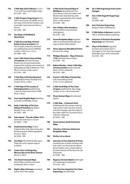
755 C18th Map Gulf of Mexico 21cm x<br />
17cm with two small English maps<br />
Est $100 – 200<br />
756 C18th Prospect Engraving Brome<br />
Hall in the County of Suffolk, one of<br />
the Seats of the Rt Hon Charles Lord<br />
Cornwallis, hand coloured 36cm x<br />
49.5cm<br />
Est $100 – 200<br />
757 Two Maps of Sheffield &<br />
Manchester<br />
758 C18th Accurate Map of Great<br />
Britain France & Ireland with<br />
Part of Spain, Germany, Denmark<br />
etc published by Laurie & Whittle<br />
London 1794 51cm x 51cm<br />
Est $300 – 600<br />
759 Late C18th Hand Coloured Map<br />
of Scotland with the Principal<br />
Roads from the best Authorities,<br />
engraved for Guthries new System of<br />
Geography by Dilly & Robinson 1785<br />
38cm x 34.5cm (water stains)<br />
Est $100 – 200<br />
760 C19th Map of Northumberland<br />
published by Henry Teesdale & Co,<br />
London 42cm x 34cm<br />
761 C19th Map of The County of<br />
Nottinghamshire published by<br />
J. Duncan Paternoster Row C1840<br />
45cm x 36cm<br />
762 Four Small English Maps Berkshire,<br />
Cornwall, Cambridge, Sussex<br />
763 Early C18th Map of The East<br />
Riding Of Yorkshire by Robert<br />
Morden 37cm x 42.5cm<br />
Est $200 – 400<br />
764 John Speed – The Isle of Man 1610<br />
hand coloured 42cm x 52.5cm<br />
Est $600 – 1,200<br />
765 Small American Map of New<br />
England, New York, New Jersey and<br />
Pensilvania by H. Moll Geographer<br />
23.5cm x 34cm<br />
Est $200 - 300<br />
766 Two Maps The World of Mercators<br />
Projection and a reprint map of<br />
Scotland<br />
767 Cooks Chart of Tologa Bay<br />
Mercury Bay & The River Thames<br />
28.5cm x 44cm<br />
768 Two Hand Coloured Maps<br />
North Wales and Worcestershire<br />
(unframed) 36cm x 42cm<br />
769 Replica Map of Europe simulated<br />
vellum after John Speed<br />
770 C18th Hand Coloured Map of<br />
Middlesex described with the<br />
most famous cities of London and<br />
Westminster described by John<br />
Norden augmented by John Speed<br />
38cm x 50cm (faults)<br />
Est $200 – 400<br />
771 Pair of Maps After Hondicus<br />
of the Northern and Southern<br />
Hemispheres<br />
Est $100 – 200<br />
772 Seven Bookplate Maps together<br />
with an etching of Edinburgh and<br />
copy of Slaters Atlas (faults)<br />
773 Three Japanese Woodblock Prints<br />
all cut to the image<br />
774 Philippe Bouache – Map of Geneva<br />
1749 unframed 54cm x 80cm<br />
Est $500 – 700<br />
775 Robert Morden –Early C18th Map<br />
of Somersetshire hand coloured<br />
38cm x 44cm unframed<br />
Est $250 – 400<br />
776 French C18th Map of Dusky Bay<br />
and surrounding islands<br />
31cm x 41cm unframed<br />
777 C18th Small Map of The Coast<br />
of Japan published by Alex Hogg<br />
London 31cm x 22cm unframed<br />
778 Three Various Maps all unframed<br />
(faults)<br />
779 C18th Map – A General Chart<br />
Exhibiting the Discoveries made by<br />
Capt James Cook in his first second<br />
and third voyages with the tracks of<br />
the ships under his Command 32cm<br />
x 48.5cm unframed<br />
Est $200 – 400<br />
780 Seven Various Small Unframed<br />
Maps<br />
781 Selection of Various Unframed<br />
Bookplate Maps<br />
782 Similar Lot as above<br />
783 Selection of Five Sketches & Prints<br />
including two Scottish etchings with<br />
loch views, two Victorian European<br />
pencil studies and a small woodcut<br />
by Gwen Raverat of The River Ver (all<br />
unframed)<br />
Est $300 – 400<br />
784 Regency Portrait Sketch half length<br />
of a seated gent (unframed)<br />
Est $100 – 200<br />
785 Two Victorian Aquatints Five Steel<br />
Engravings (all unframed)<br />
786 Six C18th Engravings from Cook’s<br />
Voyages<br />
787 Two C18th Hogarth Engravings<br />
(faults)<br />
Est $500 - 600<br />
788 Four Victorian Engravings<br />
penguins New Caledonia etc<br />
789 C18th Vellum Indenture together<br />
with a small bookplate engraving<br />
790 Selection of Victorian Bookplate<br />
Engravings (all unframed)<br />
791 Chart of The World engraved<br />
by Davies & Co drawn by R. C.<br />
Carrington C1921 from the original<br />
Admiralty Chart 1874 (unframed)<br />
Est $250 - 350


