A Classification of Riparian Wetland Plant Associations of Colorado
A Classification of Riparian Wetland Plant Associations of Colorado
A Classification of Riparian Wetland Plant Associations of Colorado

You also want an ePaper? Increase the reach of your titles
YUMPU automatically turns print PDFs into web optimized ePapers that Google loves.
A <strong>Classification</strong> <strong>of</strong> <strong>Riparian</strong> <strong>Wetland</strong><br />
<strong>Plant</strong> <strong>Associations</strong> <strong>of</strong> <strong>Colorado</strong><br />
A Users Guide to the <strong>Classification</strong> Project<br />
September 1, 1999<br />
By<br />
Gwen Kittel, Erika VanWie, Mary Damm, Reneé Rondeau<br />
Steve Kettler, Amy McMullen and John Sanderson
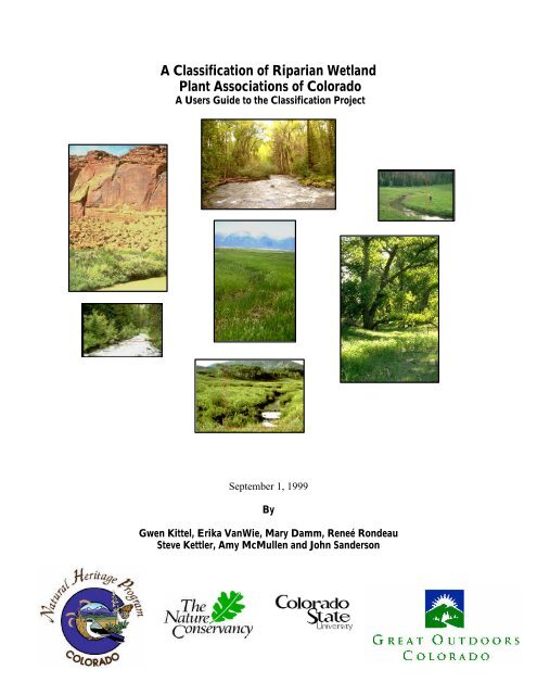
Clockwise from top:<br />
Conejos River, Conejos County, Populus angustifolia-Picea pungens/Alnus incana <strong>Riparian</strong> Woodland<br />
Flattop Wilderness, Garfield County, Carex aquatilis <strong>Riparian</strong> Herbaceous Vegetation<br />
South Platte River, Logan County, Populus deltoides/Carex lanuginosa <strong>Riparian</strong> Woodland<br />
California Park, Routt County, Salix boothii/Mesic Graminoids <strong>Riparian</strong> Shrubland<br />
Joe Wright Creek, Larimer County, Abies lasiocarpa-Picea engelmannii/Alnus incana <strong>Riparian</strong> Forest<br />
Dolores River, San Miguel County, Forestiera pubescens <strong>Riparian</strong> Shrubland<br />
Center Photo<br />
San Luis Valley, Saguache County, Juncus balticus <strong>Riparian</strong> Herbaceous Vegetation<br />
(Photography by Gwen Kittel)<br />
2
Prepared by:<br />
<strong>Colorado</strong> Natural Heritage Program<br />
254 General Services Bldg.<br />
<strong>Colorado</strong> State University<br />
Fort Collins, CO 80523<br />
heritage@lamar.colostate.edu<br />
This report should be cited as follows:<br />
Kittel, Gwen, Erika VanWie, Mary Damm, Reneé Rondeau, Steve Kettler, Amy McMullen, and<br />
John Sanderson. 1999. A <strong>Classification</strong> <strong>of</strong> <strong>Riparian</strong> <strong>Wetland</strong> <strong>Plant</strong> <strong>Associations</strong> <strong>of</strong> <strong>Colorado</strong>: User<br />
Guide to the <strong>Classification</strong> Project. <strong>Colorado</strong> Natural Heritage Program, <strong>Colorado</strong> State University,<br />
Fort Collins, CO. 80523<br />
For more information please contact:<br />
<strong>Colorado</strong> Natural Heritage Program, 254 General Service Building, <strong>Colorado</strong> State University, Fort<br />
Collins, <strong>Colorado</strong> 80523. (970) 491-1309 email: heritage@lamar.colostate.edu<br />
3
ACKNOWLEDGEMENTS<br />
This project would not have been possible without the help, support and guidance <strong>of</strong> the <strong>Riparian</strong><br />
Task Force. This cooperative group consists <strong>of</strong> The Nature Conservancy, the <strong>Colorado</strong> Natural<br />
Heritage Program, the Environmental Protection Agency, the US Forest Service, the US Bureau <strong>of</strong><br />
Land Management, the US Bureau <strong>of</strong> Reclamation, US Park Service, US Natural Resources<br />
Conservation Service, The US Fish and Wildlife Service, the US Geological Survey, the <strong>Colorado</strong><br />
Department <strong>of</strong> Health, the <strong>Colorado</strong> Division <strong>of</strong> Parks and Outdoor Recreation, the <strong>Colorado</strong><br />
Department <strong>of</strong> Wildlife, and the Denver Board <strong>of</strong> Water Commissioners.<br />
I’d like to thank our funding sources, which, over the coarse <strong>of</strong> nine years, have contributed a total<br />
<strong>of</strong> $846,000. Grants ranged from large (>$50,000) to small (
TABLE OF CONTENTS<br />
ACKNOWLEDGEMENTS........................................................................................................................... 4<br />
SUMMARY ........................................................................................................................................................ 6<br />
INTRODUCTION........................................................................................................................................... 7<br />
METHODS........................................................................................................................................................ 8<br />
Pre-Field Site Selection............................................................................................................... 8<br />
Ariel Photograph Interpretation .................................................................................................. 9<br />
Field Data Collection ................................................................................................................ 10<br />
Site Ranking Criteria................................................................................................................. 12<br />
Data Analysis and <strong>Classification</strong> Development........................................................................ 13<br />
The United States National Vegetation <strong>Classification</strong> ...............................................................................13<br />
A CLASSICATION OF RIPARIAN WETLAND PLANT ASSOCIATIONS..................................17<br />
List <strong>of</strong> <strong>Riparian</strong> <strong>Wetland</strong> <strong>Plant</strong> <strong>Associations</strong> <strong>of</strong> <strong>Colorado</strong>........................................................ 17<br />
List <strong>of</strong> CNHP Ranks ................................................................................................................. 22<br />
Map <strong>of</strong> Plot Locations used to build the <strong>Riparian</strong> <strong>Classification</strong> (1990-1998), COError! Bookmark not defined.<br />
BASIN BY BASIN SUMMARY...................................................................................................................23<br />
Arkansas River Basin ....................................................................................................................................24<br />
<strong>Colorado</strong> River Basin....................................................................................................................................26<br />
Gunnison River Basin...................................................................................................................................28<br />
Lower San Juan River Basin.........................................................................................................................30<br />
North Platte Watershed................................................................................................................................32<br />
Rio Grande and Closed Basin Watersheds................................................................................................34<br />
Routt National Forest...................................................................................................................................38<br />
San Juan National Forest..............................................................................................................................40<br />
San Miguel and Dolores River Basins ........................................................................................................43<br />
South Platte Watershed ................................................................................................................................45<br />
White River Basin..........................................................................................................................................48<br />
Yampa River Basin........................................................................................................................................50<br />
USER GUIDE to PLANT ASSOCIATION COMMUNITY CHARACTERIZATION<br />
ABSTRACTS (CCAs) .....................................................................................................................................51<br />
LITERATURE CITED .................................................................................................................................54<br />
APPENDIX 1. Key to <strong>Riparian</strong> <strong>Wetland</strong> <strong>Plant</strong> <strong>Associations</strong> <strong>of</strong> <strong>Colorado</strong>............................................69<br />
APPENDIX 2. <strong>Riparian</strong> Field Form and Manual. .....................................................................................70<br />
APPENDIX 3. Location, Rank, and <strong>Plant</strong> Association for each plot.....................................................71<br />
5
SUMMARY<br />
This report presents the final <strong>Classification</strong> <strong>of</strong> Natural <strong>Riparian</strong>/<strong>Wetland</strong> <strong>Plant</strong> <strong>Associations</strong> for<br />
<strong>Colorado</strong>. This is the culmination <strong>of</strong> a nine year project to develop a comprehensive, field-based,<br />
classification <strong>of</strong> riparian wetland plant associations for the state <strong>of</strong> <strong>Colorado</strong>. Over 1880<br />
quantitative plots were collected between 1990 and 1999, using a systematic, stratified-random<br />
method applied to all 12 watersheds in the state.<br />
One hundred fifty (150) native plant associations are described. These include conifer forests,<br />
deciduous woodlands, willow shrublands, non-willow shrublands, herbaceous meadows, alkaline<br />
flats, acidic fens, and alpine peat bogs that occur on USGS designated perennial and ephemeral<br />
streams at the 1:12,000 scale. <strong>Riparian</strong> wetlands include broad meandering river floodplains with<br />
complex mosaics <strong>of</strong> several plant associations, narrow stream reaches, to dry gullies.<br />
The classification also covers active alluvial rivers, beaver activity-driven ecosystems, and stable,<br />
subalpine wetlands. The classification does not described tamarisk and Russian olive dominated<br />
riparian areas, or areas dominated by other non-native plant species. However, with over 1880<br />
plots, not all riparian areas sampled were in pristine condition.<br />
Sampling occurred on Federal, State, County, City and private land. Private land was only accessed<br />
with the permission <strong>of</strong> the landowner. Reference reaches were located in each watershed.<br />
Significant findings and Reference Reaches are summarized for each watershed.<br />
This classification covers an estimated 80-90% <strong>of</strong> <strong>Colorado</strong>’s riparian wetland diversity, so not all <strong>of</strong><br />
the riparian associations that occur on the landscape are be described in this report. Some plant<br />
associations are very rare and unique to <strong>Colorado</strong>, known from five or fewer places in the state.<br />
Others are quite common, and are known from literately hundreds <strong>of</strong> streams.<br />
Of the one-hundred fifty riparian plant associations 11% (17) are ranked G1—critically imperiled<br />
globally; 17% (26) are ranked G2—imperiled globally, 29%(49) are ranked G3—vulnerable, 24%<br />
(36) are ranked G4—apparently secure globally, 15% (23) are ranked G5—demonstrably secure<br />
globally, and 1% (5) remained unranked.<br />
<strong>Colorado</strong>’s riparian areas cover less than 3 percent <strong>of</strong> the land area in the state, yet they house 40%<br />
<strong>of</strong> all the known plant species in the State, (1220 taxa), some <strong>of</strong> the rarest wetland plant associations<br />
known in the west, and provide habitat for nearly 80% <strong>of</strong> the wildlife species that live and migrate<br />
through <strong>Colorado</strong><br />
This report includes:<br />
• A review <strong>of</strong> the project, <strong>of</strong>fice and field methods.<br />
• Review <strong>of</strong> findings and Reference Reaches in each River basin.<br />
• Table <strong>of</strong> 150 plant associations and their conservation ranks; CNHP rank definitions.<br />
• Vegetative Key to the <strong>Riparian</strong> <strong>Wetland</strong> <strong>Plant</strong> <strong>Associations</strong> <strong>of</strong> <strong>Colorado</strong> (Appendix 1).<br />
• <strong>Riparian</strong> field form used and its manual (Appendix 2).<br />
• A list <strong>of</strong> all plot locations, site rank and plant association (Appendix 3).<br />
6
INTRODUCTION<br />
<strong>Riparian</strong> areas, highly used and abused in <strong>Colorado</strong>, are <strong>of</strong> great importance for maintaining water<br />
quality and quantity, stabilizing stream banks, and providing habitat for fish and other wildlife<br />
species (Hansen et al. 1988, Brinson et al. 1981). <strong>Riparian</strong> areas are the biological and physical link<br />
between terrestrial and aquatic ecosystems (Youngblood et al. 1985). These areas are used<br />
extensively for domestic livestock grazing, gravel mining, recreational purposes, and as<br />
transportation corridors. The ecology <strong>of</strong> riparian areas and their response to various land<br />
management practices is variable and <strong>of</strong>ten poorly understood. Consequently, resource<br />
management and conservation decisions for many riparian areas can be far from optimal.<br />
Our knowledge <strong>of</strong> riparian plant associations in <strong>Colorado</strong> has been both limited and fragmented.<br />
Patchy and scattered inventory work, using a variety <strong>of</strong> methodologies, has been conducted in<br />
<strong>Colorado</strong>. Areas include the Piceance Basin (Baker 1982), along the more accessible portions <strong>of</strong> the<br />
main stem <strong>of</strong> the Yampa River (by the <strong>Colorado</strong> Natural Areas Program), and the Yampa River<br />
within Dinosaur National Monument (Fisher et al. 1983). The Nature Conservancy has funded<br />
classification and surveys <strong>of</strong> riparian vegetation in west-central and southwestern <strong>Colorado</strong> (Baker<br />
1986), and the northern Front Range (Cooper and Cottrell 1990). <strong>Plant</strong> community and habitat<br />
classification by the National Forests (Hess and Alexander 1986, Hess and Wasser 1982, Komarkova<br />
1979, Komarkova et al. 1988, DeVelice et al. 1985) have not specifically focused on riparian areas.<br />
Elsewhere in the Rocky Mountain Region, riparian classification has been conducted in eastern<br />
Idaho and western Wyoming (Youngblood et al. 1985), eastern Wyoming (Jones 1990, Jones and<br />
Walford 1995), New Mexico (Muldavin 1992, Durkin et al. 1994, 1995), Montana (Hansen et al. 1988,<br />
1989, 1995), Nevada (Manning and Padgett 1989, Manning and Padgett 1995), and Utah (Padgett et<br />
al. 1989). No single project or document describes what riparian wetland resources occur in<br />
<strong>Colorado</strong>, or how they may be related to this body <strong>of</strong> literature. The state wide classification project<br />
was designed to produce such a document.<br />
This project constitutes the first comprehensive riparian classification effort for <strong>Colorado</strong>. Since<br />
1990, basin-wide, systematic riparian classification has been conducted each year, focusing on the 12<br />
major watersheds <strong>of</strong> <strong>Colorado</strong>. At the same time, two National Forests and one National Grassland<br />
were sampled with the same methodology. Completed watersheds and Forest Service lands include:<br />
the Yampa and San Miguel/Dolores River basins (Kittel and Lederer 1993), the White and <strong>Colorado</strong><br />
River basins (Kittel et al. 1994), the Gunnison River Basin (Kittel et al. 1995), the San Juan and Routt<br />
National Forests (Richard et al. 1996, Kettler and McMullen 1996), the South Platte watershed<br />
(Kittel et al. 1998), part <strong>of</strong> the Comanche National Grassland (Culver et al 1996), the Rio Grande<br />
and Closed Basins (Kittel et al. 1999), and the upper (I-25 corridor up to the continental divide)<br />
Arkansas River basin (Kittel et al. 1996).<br />
In 1998, we completed basin wide coverage <strong>of</strong> the entire state by continuing the method in the<br />
North Platte River basin, the lower San Juan River basin (below San Juan National Forest<br />
boundaries to the state line), and the lower Arkansas (roughly the I 25 corridor east to the state line,<br />
including the Cimarron River watershed). In this report, we present the final classification <strong>of</strong><br />
riparian wetland vegetation for <strong>Colorado</strong>.<br />
Homogeneous stands <strong>of</strong> riparian vegetation are classified into <strong>Plant</strong> <strong>Associations</strong> based on similar<br />
floristic composition and environmental setting. The classification is part <strong>of</strong> the United States<br />
7
National Vegetation <strong>Classification</strong> System (USNVS), developed and maintained by The Nature<br />
Conservancy (Grossman et al. 1998, Anderson et al. 1998). The classification is based on a<br />
hierarchical physiognomic and ecological structure (Grossman et al. 1998). In this report, we<br />
crosswalk Alliances and <strong>Plant</strong> <strong>Associations</strong> with <strong>Wetland</strong> and Deepwater Habitats <strong>of</strong> the United<br />
States (Cowardin et al. 1979).<br />
This classification is subject to peer review, field testing, and revision. As new data are collected<br />
from different basins, information will be incorporated into the classification. Information<br />
pertaining to rare or high quality occurrences <strong>of</strong> common plant associations will be incorporated<br />
into the Biological and Conservation Database <strong>of</strong> Rare and Imperiled Natural Communities,<br />
updated and maintained by the <strong>Colorado</strong> Natural Heritage Program (CNHP), and the Terrestrial<br />
Vegetation for the United States (Anderson et al. 1998).<br />
This project is a cooperative effort by the <strong>Riparian</strong> Task Force, a group <strong>of</strong> state and federal<br />
government agency representatives, which in cooperation with The Nature Conservancy's <strong>Colorado</strong><br />
Program and the <strong>Colorado</strong> Natural Heritage Program, supports the project through in-kind services,<br />
financial support, and technical assistance. The <strong>Riparian</strong> Task Force, formalized in 1993 by a<br />
Memorandum <strong>of</strong> Understanding (MOU), consists <strong>of</strong> steering and technical committees that meet<br />
once a year to review methods and results, and to discuss the continued support for the statewide<br />
classification project.<br />
METHODS<br />
<strong>Riparian</strong> areas are defined as the interface between the riverine aquatic ecosystem and the adjacent<br />
upland ecosystem (Gregory et al. 1991, Risser 1990, Knopf et al. 1988, Brinson et al. 1981). These<br />
areas are frequently flooded, or are at least seasonally saturated by a fluctuating water table, and have<br />
plant species, soils, and topography that differ considerably from those <strong>of</strong> the adjacent uplands<br />
(Elmore and Beschta 1987, Jones 1990). <strong>Riparian</strong> areas studied during this project include<br />
vegetation occurring along natural water courses, poorly drained overflow areas, and associated<br />
natural bodies <strong>of</strong> water, such as oxbow lakes. The classification focuses on perennial and<br />
intermittent (streams that were marked perennial for at least 1 mile <strong>of</strong> their length) as defined on<br />
U.S. Geological Survey 1:24,000 and 1:100,000 topographic maps.<br />
Pre-Field Site Selection<br />
To sample as much <strong>of</strong> the diversity within each basin as possible in one field season, we used a<br />
stratified-random approach based on the Austin and Heyligers (1989) gradsect concept. Two<br />
environmental gradients thought to influence riparian vegetation were chosen to stratify the study<br />
area. Each mile <strong>of</strong> every stream within the study area was placed within a cell-type, a combination<br />
<strong>of</strong> the two stratifying variables.<br />
Two environmental variables used were: 1) stream order as a surrogate for basin size, channel size<br />
and stream volume (Schumm 1977, Knighton 1984), and 2) elevation as an important predictor <strong>of</strong><br />
climate. Using USGS 1:100,000 topographic maps we denoted 1,000 ft (300 m) elevation bands<br />
from 5,000 ft (1,525 m) to over 10,000 ft (3,050 m) and first through fifth order stream classes,<br />
calculated for each mile <strong>of</strong> perennial stream using Strahler's (1952) system.<br />
8
The total perennial and intermittent (streams that were marked perennial for at least 1 mile <strong>of</strong> their<br />
length) stream miles in the basin were tallied by cell type and their percentage for the basin<br />
calculated. Aerial photographs were used to eliminate areas <strong>of</strong> heavy disturbance (explained in more<br />
detail below). Over 200 one-mile long stream reaches were randomly selected in each study area,<br />
representing all the classification cell types, weighted by their abundance in the basin. For example,<br />
if 20% <strong>of</strong> the stream miles above 10,000 ft (3,050 m) were first order streams, then 20% <strong>of</strong> the<br />
randomly selected one-mile sites would be <strong>of</strong> that type. Thus the number <strong>of</strong> sampled stream miles<br />
per cell type was representative <strong>of</strong> the basin.<br />
In addition to sampling a representative selection <strong>of</strong> potential habitats, we also tried to sample<br />
riparian areas which have not been drastically altered by human activity in the sampling regime,<br />
thereby limiting the classification to plant associations native to <strong>Colorado</strong>, whose descriptions can<br />
serve as a reference point for management and restoration needs. This was not always possible,<br />
especially at lower elevations, and, <strong>of</strong> course, was subject to our own interpretation <strong>of</strong> natural and<br />
potential vs. changed vegetation due to human activities. We assumed that current wildlife<br />
populations and fire frequencies have been altered ubiquitously across the landscape and is constant<br />
“background noise” in our data set.<br />
The term “relatively undisturbed” refers to the difference between the most altered reach to the least<br />
altered reach within the watershed, as opposed to some theoretical “pristine” criteria. In any case,<br />
by observing riparian areas systematically across the watershed and the state, we have gained a pretty<br />
good idea as to the status, condition and trend <strong>of</strong> riparian ecosystems within the study area and<br />
across <strong>Colorado</strong>.<br />
<strong>Riparian</strong> corridors were ranked by their condition (amount <strong>of</strong> human-induced disturbance) at two<br />
scales. First, from small-scale color infrared aerial photographs (1989, 1990 NAPP 1:40,000, 1983<br />
1:24,000) to block out obvious severely altered riparian reaches (see list <strong>of</strong> specific criteria starting on<br />
page 11). The amount <strong>of</strong> disturbance on surrounding lands can be a strong predictor <strong>of</strong> the amount<br />
<strong>of</strong> non-native species in the understory within the riparian corridor (Rondeau and Kittel 1994).<br />
Areas indicating heavy disturbance were eliminated prior to random selection <strong>of</strong> reaches for<br />
sampling.<br />
Second, each randomly chosen reach was evaluated again for its condition in the field (mainly for<br />
the amount <strong>of</strong> grazing impact and presence <strong>of</strong> non-native plant species, criteria that cannot be<br />
adequately assessed from small-scale photographs).<br />
Aerial Photograph Interpretation<br />
Disturbance criteria used for both small (aerial photography) and large (on the ground) scale<br />
assessments were:<br />
1. Drastic disturbance where riparian vegetation has been removed or fragmented such that less<br />
than 50% <strong>of</strong> the riparian corridor remains in tact. Signs such disturbance at small scales are:<br />
agricultural/urban conversion, constricting or encroaching irrigated fields, square-edge fields,<br />
road and railroad embankments, channelized river reaches, power line maintenance roads, within<br />
channel and floodplain gravel mining, surrounding hillslope activities such as logging, and<br />
mining, and proximity to dams and reservoirs.<br />
2. Heavy recreational use, such as <strong>of</strong>f-road vehicle use, high density camping impacts, social trails<br />
and the like.<br />
9
3. Chronic heavy livestock use (improper grazing practices) where hillside trailing occurs,<br />
accelerated bank erosion/destabilization, or abundant increaser species are present; basically sites<br />
with severe improper livestock management as outlined in Valentine (1990).<br />
4. Road maintenance activities, including grading, bridge repair/improvements, road widening,<br />
snow-removal practices that impact vegetation; channel bed re-configuration for irrigation head<br />
gates, gravel/sand mining sites, or other dumping grounds.<br />
All riparian corridors were classified into four condition categories from the small scale (1:40,000)<br />
aerial photography assessment criteria:<br />
1. Excellent-- riparian corridor and the surrounding area appear natural with no major disturbances.<br />
Within the corridor itself, the area appears unfragmented and the vegetation follows a natural<br />
pattern, and the corridor is large (>1 mile long);<br />
2. Good--riparian corridor exhibits excellent vegetative cover but the surrounding area is somewhat<br />
altered, the corridor maybe large (>1 mile long) but somewhat disturbed, or the corridor smaller<br />
(80% <strong>of</strong> its length. Deep canyons are an exception<br />
to the above criteria, as they tend to have naturally low amounts <strong>of</strong> riparian vegetation. If the<br />
surrounding land looked undisturbed, a canyon reach would be ranked “good” also.<br />
BLM 1:100,000 topographic and land ownership maps were overlain with the aerial photographs.<br />
River miles were tallied by ownership (federal, state, and private) and condition category. During<br />
field site visits, we further evaluated randomly chosen reaches for the amount <strong>of</strong> improper grazing<br />
(difficult to asses from aerial photographs) and weedy species. Sites were eliminated from sampling<br />
if they were severely degraded by improper grazing as well as if they were dominated by non-native<br />
plant species such as tamarisk or salt cedar (Tamarix ramosissima) or Russian-olive (Elaeagnus<br />
angustifolia). Areas with non-natives present, such as Kentucky bluegrass (Poa pratensis), but where<br />
native flora dominated the overstory vegetation, were included in the sampling regime.<br />
Field Data Collection<br />
Field site visits were conducted June 1st through October 15th. Private land was accessed only with<br />
landowner permission. Each randomly chosen reach was assessed in the field for quality condition.<br />
Once a site has passed the “relatively undisturbed test” (explained in the previous section), we<br />
proceed to collected the following data at each plot:<br />
• elevation (from 7.5 min. topographic maps)<br />
• aspect and stream bearing<br />
• valley floor width (from topographic maps)<br />
• stream gradient (measured with a hand level and stadia rod)<br />
• channel depth and width (measured at bankfull or average annual high water mark) Bankfull stage<br />
or Bankfull channel is the height <strong>of</strong> the average 1-3 year return flow, also called the average annual<br />
high water mark <strong>of</strong> the active channel (Knighton 1984, Wolman and Leopold 1957). We use<br />
10
this demarcation along the bank as a reference point for measuring stream channel width and<br />
depth, and the height and distance <strong>of</strong> a riparian community from the active channel.<br />
• Stream reaches were placed into Rosgen's Stream channel classification (Rosgen 1994). This<br />
system is based on the channel width to depth ratio, available floodplain width, channel gradient<br />
and sinuosity, among other criteria.<br />
• Hydrologic and geomorphic features (beaver dams, point bars, etc.)<br />
• History <strong>of</strong> use (from landowner or manager) when obtainable<br />
• Woody vegetation was quantitatively sampled for percent cover using 30-50 m long lineintercept<br />
transects, oriented parallel to the stream channel. Transects were subjectively located<br />
within a homogeneous portion <strong>of</strong> each stand to best represent the vegetation <strong>of</strong> the site.<br />
• Herbaceous vegetation was sampled using 10-20 0.10 m 2 micro-plots, located about every third<br />
meter along a transect and 1 meter to the side, alternating sides.<br />
• Woody and Herbaceous vegetation was measured as percent canopy cover by vascular plant<br />
species to the nearest 10% in the following cover classes: 5-15%, 16-25%, 26-35%, 36-45%, 46-<br />
55%, 56-65%, 66-75%, 76-85%, 86-95%, and >95%. <strong>Plant</strong> cover 5% or less was estimated into<br />
two categories,
Site Ranking Criteria<br />
A Site Quality Rank was given to each riparian area sampled. These range from A (highest) through<br />
D (poorest) for overall riparian health and condition. In 1995 overall riparian quality was an average<br />
<strong>of</strong> the following four criteria: Quality--overall size, connectedness to surrounding natural ecosystems,<br />
degree <strong>of</strong> alteration; Condition--abundance <strong>of</strong> non-native plant species, degree <strong>of</strong> soil compaction,<br />
amount <strong>of</strong> species composition change by livestock grazing, degree <strong>of</strong> human disturbance,<br />
appropriateness <strong>of</strong> current management for riparian ecosystem health; Viability—are extrinsic<br />
factors necessary for long term survival <strong>of</strong> this ecosystem (e.g. hydrological processes, overall trend<br />
<strong>of</strong> site under current management) present?; Defensibility--extrinsic and intrinsic factors affecting the<br />
long term existence <strong>of</strong> the ecosystem; any known threats or site specific problems are defined;<br />
adjacent land use compatibility is included.<br />
In 1997, riparian quality ranking criteria was revised, using the same scale (A through D) and again<br />
an average <strong>of</strong> the following criteria: Size—the extent <strong>of</strong> the community, now and relative to its<br />
presettlement extent. Condition—An integrated measure <strong>of</strong> the quality <strong>of</strong> biotic and abiotic factors<br />
(structure and processes) at the local, within site (riparian mosaic) scale, including the occurrence<br />
and the degree to which they affect the continued existence <strong>of</strong> the stand. This includes: stand age,<br />
ecological processes, species composition, and abiotic physical factors (e.g. stability <strong>of</strong> substrate,<br />
water quality and soil compaction); and Landscape Context—An integrated measure <strong>of</strong> the quality <strong>of</strong><br />
biotic and abiotic factors at the landscape scale, structures and processes surrounding the site area<br />
including the riparian area itself. Note the adjacent land use(s), the degree <strong>of</strong> habitat fragmentation<br />
in the surrounding landscape. What hydrologic manipulation has occurred within the watershed?<br />
See Appendix 3 for examples <strong>of</strong> the 1995 and 1997 plot forms (page 3 <strong>of</strong> the forms has site ranking<br />
criteria).<br />
For example, an A- ranked occurrence <strong>of</strong> a riparian plant association has no, or very few, nonnative<br />
plant species present, the channel and banks are stable and show no signs <strong>of</strong> trampling or<br />
sloughing, and the soils are not compacted. The association is surrounded by other riparian<br />
associations <strong>of</strong> similar quality, creating a connected, high quality mosaic. The surrounding hillslopes<br />
and areas up and down stream are in natural condition and have not been drastically altered (no<br />
dams or diversions upstream, no logging or mining up stream <strong>of</strong> adjacent hillslopes). A B-ranked<br />
occurrence <strong>of</strong> a riparian plant association may have all <strong>of</strong> the above `A' criteria but is very small in<br />
size, or has a higher abundance <strong>of</strong> non-native plant species present, or may be an area in high<br />
condition with surrounding land use that fragments the occurrence. A C-ranked occurrence is <strong>of</strong><br />
poor condition, generally with abundant non-native plant species present and/or the area is highly<br />
fragmented, and/or the area is very small. Again surrounding land use and condition plays a role in<br />
the overall riparian occurrence rank.<br />
<strong>Riparian</strong> areas recommended for special management or protection are examples <strong>of</strong> "A" or "B"<br />
ranked occurrences. These ecologically significant sites are valuable as reference areas for long-term<br />
research and comparison with impacted areas.<br />
High-quality riparian areas found in the Rio Grande and Closed Basin are proposed as some <strong>of</strong> the<br />
best examples <strong>of</strong> rare or common riparian plant associations in the State. The <strong>Colorado</strong> Natural<br />
Heritage Program will be entering these areas into the Biological and Conservation Database and<br />
ranking these sites for final protection recommendation.<br />
12
Data Analysis and <strong>Classification</strong> Development<br />
Agglomerative cluster analysis was employed using Euclidean distance (a similarity index distance<br />
measure) and average clustering method to determine groups <strong>of</strong> plots with similar species<br />
abundance (Figures 4, 5 and 6)(see Ludwig and Reynolds 1988 for further explanation <strong>of</strong> this<br />
method). <strong>Plant</strong> <strong>Associations</strong> derived from the cluster analyses were compared with riparian plant<br />
association stand data and descriptions from riparian classification work in <strong>Colorado</strong>, New Mexico,<br />
Arizona, Utah, Montana, Idaho and Wyoming (Johnston 1987, Muldavin 1992, Durkin et al. 1994,<br />
1995, Szaro 1989, Padgett et al. 1989, Hansen et al. 1988, 1989, and Youngblood et al. 1985,<br />
respectively). <strong>Associations</strong> were considered either 1) synonymous --where associations matched in<br />
species composition, constancy, average cover, environmental setting, 2) similar --when canopy<br />
structure, genera, and physical setting were similar, but species composition was different, 3) a new<br />
type not described in the literature, or 4) unclassifiable due to insufficient data.<br />
<strong>Plant</strong> association names are based on each canopy stratum dominant and codominant plant species,<br />
characterized by high constancy (frequency <strong>of</strong> species occurrence) and high relative abundance<br />
(percent canopy cover) values. A slash separates canopy layers (e.g., tree/shrub/herb). A dash<br />
indicates co-dominance within a given canopy layer (e.g., Populus angustifolia-Pseudotsuga menziesii).<br />
<strong>Plant</strong> associations that appear synonymous with those in the literature (by stand table and<br />
description comparison) are given the same names. Some published names are long and awkward;<br />
we propose shorter names herein.<br />
The United States National Vegetation <strong>Classification</strong> (USNVS)<br />
<strong>Riparian</strong> plant associations presented here are incorporated into the United States National<br />
Vegetation <strong>Classification</strong> System (USNVS), developed and maintained by The Nature Conservancy<br />
(Grossman et al. 1998, Anderson et al. 1998). This system is based on key elements to best<br />
incorporate existing systems and information, and to best fit the needs <strong>of</strong> conservation. The<br />
classification: 1) is vegetation-based, 2) uses a systematic approach, 3) emphasizes natural vegetation, 4)<br />
emphasizes existing vegetation, 5) uses a combined physiognomic-floristic hierarchy, identifying<br />
vegetation units at scales practical for conservation, and 6) is appropriate for mapping at multiple<br />
scales (emphasis by the author).<br />
The classification is based on existing, relatively undisturbed (by human impacts) vegetation in all<br />
seral stages. A plant association, the most specific level in this hierarchical classification, is defined as<br />
“natural vegetation with definite floristic composition, uniform physiognomy, and uniform habitat”<br />
(Mueller-Dombois and Ellenberg 1974). This is not the same as the USDA Forest Service adopted<br />
concept <strong>of</strong> a “plant association” (Daubenmire 1952), a term reserved for only the potential climax<br />
vegetation. <strong>Plant</strong> associations in the USNVS system are defined as a product <strong>of</strong> the prevailing<br />
environmental setting (where possible, barring human influence or pre-European settlement)<br />
including past natural disturbances (such as fire, flooding, or bison grazing) and are "real, extant ...<br />
kinds <strong>of</strong> vegetation, rather than a theoretical end point that is seldom reached on most sites" (Baker<br />
1984).<br />
Along riparian corridors, flooding and sediment deposition and scouring create an environment that<br />
is frequently disturbed. Thus most riparian communities are frequently set back in successional<br />
time, and the floodplain mosaic is <strong>of</strong>ten a series successional stages. Thus many <strong>of</strong> the plant<br />
13
associations described here would be equal to “community types” described by USDA Forest<br />
Service publications (e.g. Padgett et al. 1989).<br />
The Hierarchical Physiognomic and Floristic <strong>Classification</strong> <strong>of</strong> the United States National Vegetation<br />
<strong>Classification</strong> System (USNVS) is structured as follows:<br />
• Division-- the first level in the classification system separates the Earth into either vegetated<br />
(>1%) or non-vegetated categories.<br />
• Order-- Dominant life form (tree, shrub, dwarf shrub, herbaceous, or non-vascular).<br />
• Class-- Relative percent canopy cover <strong>of</strong> the life form in the upper most strata during<br />
the peak <strong>of</strong> the growing season (Forest, woodland, shrubland, and barrens).<br />
• Subclass--Predominant leaf phenology <strong>of</strong> the classes defined by tree, shrub, or<br />
dwarf shrub stratum (evergreen, deciduous, mixed evergreen-deciduous), and the<br />
average vegetation height for herbaceous stratum (tall, medium, short).<br />
• Group-- A combination <strong>of</strong> climate, leaf morphology, and leaf phenology (e.g.<br />
Subtropical drought-deciduous forest, Temperate rainforest).<br />
• Subgroup-- Separates natural/semi-natural types from the<br />
planted/cultivated types.<br />
• Formation--Ecological groups with broadly defined environmental<br />
(e.g. hydrology) and additional physiognomic factors (e.g.).<br />
• Alliance--aggregation <strong>of</strong> <strong>Plant</strong> <strong>Associations</strong> and characterized by<br />
a diagnostic species, which as a rule, occur in the dominant or<br />
uppermost stratum <strong>of</strong> the vegetation (Picea pungens Seasonally<br />
Saturated Alliance).<br />
• <strong>Plant</strong> Association-- the basic floristic unit <strong>of</strong> this<br />
classification system, characterized by a diagnostic species<br />
that occur in the overstory and understory <strong>of</strong> the vegetation<br />
(e.g. Picea pungens/Alnus incana Seasonally Saturated Forest).<br />
14
Cross-reference <strong>of</strong> the US National Vegetation <strong>Classification</strong> (USNVC) (Grossman et al. 1998<br />
and Anderson et al. 1998) and the <strong>Wetland</strong> and Deep Water Habitat Types <strong>of</strong> the U.S. (Cowardin<br />
et al. 1979). ____________<br />
USNVC COWARDIN<br />
DIVISION: Vegetated (>1%)<br />
Order: Tree Dominated<br />
Palustrine system-Forested class<br />
Class: II. Open Tree Canopy (25-60%)<br />
Subclass: A. Evergreen Open Tree Canopy Needle-leaved evergreen subclass<br />
Group: 4. Temperate or subpolar<br />
Subgroup: (N). Natural/Semi-natural<br />
Formation: e. Seasonally flooded/ saturated<br />
Floristic level (1) Alliance<br />
(Dominance type)<br />
Floristic level (2) <strong>Plant</strong> Association<br />
Subclass: B. Deciduous Open Tree Canopy<br />
Group: 2. Cold-deciduous<br />
Subgroup: (N). Natural/Semi-natural<br />
Formation: c. Seasonally flooded/ saturated<br />
Floristic level (1) Alliance<br />
Floristic level (2) <strong>Plant</strong> Association<br />
Subclass: C. Mixed evergreen-deciduous<br />
Group: 3. Cold-deciduous<br />
Subgroup: (N). Natural/Semi-natural<br />
Formation: b. Seasonally flooded/saturated<br />
Floristic Level (1) Alliance<br />
Floristic Level (2) <strong>Plant</strong> Association<br />
Order: Shrub Dominated<br />
Class: Shrubland<br />
Subclass: B. Deciduous Shrubs<br />
Group: 2. Cold-deciduous<br />
Subgroup: (N). Natural/Semi-natural<br />
Formation: b. Subalpine or subpolar<br />
Floristic level (1) Alliance<br />
Floristic level (2) <strong>Plant</strong> Association<br />
Formation: c. Seasonally flooded/saturated<br />
Floristic level (1) Alliance<br />
Floristic level (2) <strong>Plant</strong> Association<br />
Order: Herb/Nonvascular<br />
Class: Herbaceous Dominated<br />
Subclass: A. Perennial graminoid (>50%<br />
relative graminoid cover)<br />
Group: Temperate or subpolar grassland<br />
Subgroup: (N). Natural/Semi-natural<br />
Formation: k. Seasonally flooded/ saturated<br />
15<br />
Palustrine system-Forested class<br />
Broad-leaved deciduous subclass<br />
(Dominance type)<br />
Palustrine system-Forested class<br />
Broad-leaved deciduous subclass<br />
(Dominance type)<br />
Palustrine-Scrub-Shrub Shrubland<br />
Deciduous--class<br />
(Dominance type)<br />
(Dominance type)<br />
Palustrine-Emergent Persistent<br />
<strong>Wetland</strong>s
Cross reference <strong>of</strong> USNVC and Cowardin, Continued.<br />
USNVC COWARDIN<br />
Floristic level (1) Alliance<br />
Floristic level (2) <strong>Plant</strong> Association<br />
Subclass: Perennial Forb vegetation (50%<br />
relative >forb cover)<br />
Group: 2. Temperate or subpolar<br />
Subgroup: (N). Natural/Semi-natural<br />
Formation: e. Saturated temperate forb vegetation<br />
Floristic level (1) Alliance<br />
Floristic level (2) <strong>Plant</strong> Association<br />
Subclass: Hydromorphic rooted vegetation.<br />
Group: Temperate<br />
Subgroup: (N.) Natural/Semi-natural<br />
Formation: a. Non-tidal Hydromorphic rooted<br />
vegetation.<br />
Floristic level (1) Alliance<br />
Floristic level (2) <strong>Plant</strong> Association<br />
16<br />
(Dominance type)<br />
Riverine System-Upper Perennial<br />
Persistent-Emergent <strong>Wetland</strong>s<br />
(Dominance type)<br />
Riverine System-Upper Perennial<br />
Persistent-Emergent <strong>Wetland</strong>s<br />
(Dominance type)<br />
______________________________________________________________________________
A CLASSICATION OF RIPARIAN WETLAND PLANT ASSOCIATIONS<br />
A classification <strong>of</strong> natural, native riparian vegetation has been developed for <strong>Colorado</strong>. This<br />
classification is based entirely on data collected in the field, between 1990 and 1998. Field sites were<br />
chosen to represent the diversity <strong>of</strong> habitats available in <strong>Colorado</strong> (see Method section for more<br />
information). The table below lists the 150 plant associations developed and described in this<br />
classification. A full description <strong>of</strong> each association can be found on the 3.5” floppy disk included<br />
in this report. See the table below for the corresponding file name. See Figure 1, for a map <strong>of</strong><br />
<strong>Colorado</strong> and the 1880 plot locations.<br />
A Field Key to the associations is located in Appendix 1.<br />
Example field forms and the manual to the forms used are located in Appendix 2.<br />
A list <strong>of</strong> location, rank, and plant association for 1883 plots is located in Appendix 3.<br />
List <strong>of</strong> <strong>Riparian</strong> <strong>Wetland</strong> <strong>Plant</strong> <strong>Associations</strong> <strong>of</strong> <strong>Colorado</strong>. (See page 23 for Global and State Rank<br />
Definitions).<br />
CNHP Element Code State Name Global<br />
Rank<br />
CONIFEROUS FORESTS<br />
CRFEXXXXX1 Abies concolor-(Picea pungens)-Populus angustifolia/Acer<br />
glabrum<br />
CRFEABLA0B Abies lasiocarpa-Picea engelmannii/Alnus incana ssp.<br />
tenuifolia<br />
CRFEABLA0A Abies lasiocarpa-Picea engelmannii/Calamagrostis<br />
canadensis<br />
17<br />
State<br />
Rank<br />
CCA Filename<br />
(see enclosed<br />
floppy disk)<br />
G2 S2 abcopipu.doc<br />
G5 S5 ablaalin.doc<br />
G5 S3 ablacaca.doc<br />
CRFCABLA0I Abies lasiocarpa-Picea engelmannii/Carex aquatilis G3 S3 ablacaaq.doc<br />
CRFFPIEN0A Abies lasiocarpa-Picea engelmannii/Equisetum arvense G5 S2 ablaeqar.doc<br />
CRFEABLA0B Abies lasiocarpa-Picea engelmannii/Mertensia ciliata G5 S5 ablameci.doc<br />
CRFFABLA0B Abies lasiocarpa-Picea engelmannii/Ribes spp. G5 S3 ablarisp.doc<br />
CRFEABLA0F Abies lasiocarpa-Picea engelmannii/Salix drummondiana G5 S4 ablasadr.doc<br />
CRFEXXXXX7 Abies lasiocarpa-Picea engelmannii-Populus<br />
angustifolia/Lonicera involucrata<br />
G4 S3 ablapoan.doc<br />
CWBAJUSC1A Juniperus scopulorum/Cornus sericea G4 S2 junsccose.doc<br />
CRFEPIPU0A Picea pungens/Alnus incana ssp. tenuifolia G3 S3 pipualin.doc<br />
CRFAPIPU1A Picea pungens/Betula occidentalis G2 S2 pipubeoc.doc<br />
CRFEPIPU0G Picea pungens/Cornus sericea G4 S2 pipucose.doc
List <strong>of</strong> <strong>Riparian</strong> <strong>Plant</strong> <strong>Associations</strong> for <strong>Colorado</strong>, Continued.<br />
CRFEPIPU0H Picea pungens/Equisetum arvense G3? S2? pipueqar.doc<br />
CEGL002638 Pinus ponderosa/Alnus incana ssp. tenuifolia G2 S2 pipoalin.doc<br />
CWFAPSME1B Pseudotsuga menziesii/Betula occidentalis G3? S3 psmebeoc.doc<br />
CRFEPSME0A Pseudotsuga menziesii/Cornus sericea G4 S2 psmecose.doc<br />
CWFAPSME0B Pseudotsuga menziesii/Quercus gambelii G5 S4 psmequga.doc<br />
CWFAPSME0C Pseudotsuga menziesii/Symphoricarpos oreophilus G5 S4 psmesyor.doc<br />
MIXED DECIDUOUS-CONIFEROUS FORESTS<br />
CRFEXXXX6 Populus angustifolia-Picea pungens/Alnus incana G3 S3 popialin.doc<br />
CRFEPOAN4A Populus angustifolia-Juniperus scopulorum G2G3 S2 poanjusc.doc<br />
CRFDPOAN3M Populus angustifolia-Pseudotsuga menziesii G2? S2 poanpsme.doc<br />
DECIDUOUS FORESTS<br />
CWFDACNE2B Acer negundo/Betula occidentalis G1G2 S1 acnebeoc.doc<br />
CWFDACNE2C Acer negundo/Cornus sericea G3? S2 acnecose.doc<br />
CWFDACNE2D Acer negundo/Prunus virginiana G3 S2 acneprvi.doc<br />
CWFDACNE2F Acer negundo-Populus angustifolia/Celtis reticulata G1Q S1Q acpocere.doc<br />
CWFDACNE2A Acer negundo-Populus angustifolia/Cornus sericea G2 S2 acpocose.doc<br />
CCNHPXXX11 Populus angustifolia Sand Dune Forest G1 S1 poansand.doc<br />
CWFDPOAN3K Populus angustifolia/Alnus incana ssp. tenuifolia G3? S3 poanalin.doc<br />
CWFDPOAN3I Populus angustifolia/Betula occidentalis G3? S2 poanbeoc.doc<br />
CWFDPOAN3H Populus angustifolia/Cornus sericea G4 S3 poancose.doc<br />
CWFDPOAN3E Populus angustifolia/Crataegus rivularis G2? S2? poancrri.doc<br />
CCNHPXXX27 Populus angustifolia/mixed Salix species G3 S3 poanmixsalixspp.d<br />
oc<br />
CRFEPOAN5A Populus angustifolia/Prunus virginiana G2G3 S1 poanprvi.doc<br />
CWFDPOAN3G Populus angustifolia/Rhus trilobata G3 S3 poanrhtr.doc<br />
CCNHPXXXX2 Populus angustifolia/Salix drummondiana-Acer glabrum G1? S1? poansadr.doc<br />
CWFDPOAN3F Populus angustifolia/Salix eriocephala var. ligulifolia-<br />
Shepherdia argentea<br />
18<br />
G1 S1 poansali.doc<br />
CWFDPOAN3C Populus angustifolia/Salix exigua G4 S4 poansaex.doc
List <strong>of</strong> <strong>Riparian</strong> <strong>Plant</strong> <strong>Associations</strong> for <strong>Colorado</strong>, Continued.<br />
CRFDPOAN3N Populus angustifolia/Salix irrorata G2? S2 poansair.doc<br />
CCNHPXXXX3 Populus angustifolia/Salix lucida var. caudata G1Q S1Q poansalu.doc<br />
CWFDPOAN3M Populus angustifolia/Symphoricarpos spp. G2Q S2Q poansyal.doc<br />
CRFAPOBA0A Populus balsamifera GU SU poba.doc<br />
CPFAPODE3B Populus deltoides /Panicum virgatum G1G2 S1 podepavi.doc<br />
CPFAPODE3C Populus deltoides ssp. monilifera-(Salix<br />
amygdaloides)/Spartina pectinata<br />
19<br />
G1G2 S1 podesppe.doc<br />
NOT TRACKED Populus deltoides ssp. monilifera/Bromus inermis NA NA podebrin.doc<br />
CPFAPODE3E Populus deltoides ssp. monilifera/Carex lanuginosa G1? S1 podecala.doc<br />
CEGL000678 Populus deltoides ssp. monilifera/Muhlenbergia asperifolia G2Q S1Q podemuas.doc<br />
CPFDPODE3G Populus deltoides ssp. monilifera/Prunus virginiana G1Q S1Q podeprvi.doc<br />
CPFAPODE3D Populus deltoides ssp. monilifera/Symphoricarpos<br />
occidentalis<br />
G2G3 S2 podesyoc.doc<br />
CWFDPODEWA Populus deltoides ssp. wislizenii/Rhus trilobata G2 S2 poderhtr.doc<br />
CCNHPXXX19 Populus deltoides/Pascopyron smithii-Panicum obtusum G1G2Q S1S2 podepasmpaob.do<br />
Q c<br />
CPFAPODE3A Populus deltoides/Salix exigua G4? S3 podesaex.doc<br />
CCNHPXXX16 Populus deltoides/Sporobolus airoides G2Q S2Q podespai.doc<br />
CCNHPXXX17 Populus deltoides/Sporobolus asper G1Q S1Q podespas.doc<br />
CCNHPXXX18 Populus deltoides/Sporobolus cryptandrus G1G2Q S1S2<br />
Q<br />
podespcr.doc<br />
CEGL000944 Populus fremontii/Salix goodingii G2 S1 p<strong>of</strong>rsago.doc<br />
CRFEPOTRTA Populus tremuloides/Acer glabrum G2 S1S2 potracgl.doc<br />
CRFFPOTRTK Populus tremuloides/Alnus incana ssp. tenuifolia G3 S3 potralin.doc<br />
CEGL000648 Populus tremuloides/Betula occidentalis G2G3 S2 potrbeoc.doc<br />
CRFEPOTRTF Populus tremuloides/Cornus sericea G3 S2S3 potrcose.doc<br />
CRFFPOTRTG Populus tremuloides/Tall forb G5 S5 potrtafo.doc<br />
SHRUBLANDS<br />
CRSAALIN2A Alnus incana ssp. tenuifolia/Equisetum arvense G3? S3 alineqar.doc<br />
CWSFALIN0B Alnus incana ssp. tenuifolia/Mesic forb G3G4Q S3 alinmefo.doc<br />
CRSAALIN2C Alnus incana ssp. tenuifolia/Mesic graminoid G5Q S3 alinmegr.doc<br />
CWSFALIN0C Alnus incana ssp. tenuifolia-Cornus sericea G3G4 S3 alincose.doc<br />
CWSFALIN0A Alnus incana ssp. tenuifolia-mixed Salix species G3 S3 alinsal.doc<br />
CRSAALIN0C Alnus incana ssp. tenuifolia-Salix drummondiana G3 S3 alinsadr.doc<br />
CWSDARTRTB Artemisia tridentata/Leymus cinereus G2G3 S1 artrleci.doc<br />
CCNHPXXX23 Baccharis salicina G1G2Q S1S2<br />
Q<br />
bacsal.doc<br />
CRSABEGL1A Betula glandulosa/Mesic forb-Mesic graminoid G3G4 S3 beglmefo.doc<br />
CRSABEOCOA Betula occidentalis/Mesic forb G3 S2 beocmefo.doc<br />
CRSABEOC0B Betula occidentalis/Mesic graminoid G3 S2 beocmegr.doc<br />
CCNHPXXX21 Celtis laevigata var. reticulata G1G2Q S1S2<br />
Q<br />
cela.doc
List <strong>of</strong> <strong>Riparian</strong> <strong>Plant</strong> <strong>Associations</strong> for <strong>Colorado</strong>, Continued.<br />
CWSFCOSE0A Cornus sericea G4 S3 cose.doc<br />
CWFAPSME1A Corylus cornuta G3 S1 coco.doc<br />
CRSACRRI0A Crataegus rivularis G2Q S2Q crri.doc<br />
CWSFFOPU0A Forestiera pubescens G1G2 S1 fopu.doc<br />
CWFEFRAN0A Fraxinus anomala/Quercus gambelii GUQ S1Q franquga.doc<br />
CRWAPEFL0A Pentaphylloides floribunda/Deschampsia cespitosa G4 S3S4 pefldece.doc<br />
CPSAPRVI0A Prunus virginiana G4Q S3 prvi.doc<br />
CWSEQUGA0B Quercus gambelii/Symphoricarpos spp. G5 S3S4 qugasysp.doc<br />
CWSFRHTR0A Rhus trilobata G2 S2 rhtr.doc<br />
CWSDSAVE4A Sarcobatus vermiculatus/Distichlis spicata G4 S1 savedisp.doc<br />
CWSFSHAR0B Shepherdia argentea G3G4 S1 shar.doc<br />
CWPSSYOC0A Symphoricarpos occidentalis G4G5 S3 syoc.doc<br />
CRWASABE2A Salix bebbiana/Mesic graminoid G3? S2 sabe.doc<br />
CRWASABO0B Salix boothii/Carex utriculata G4 S3 sabocaut.doc<br />
CRWASABO0D Salix boothii/Mesic forb G3 S3 sabomefo.doc<br />
CRWASABR0C Salix brachycarpa/Carex aquatilis G2G3 S2S3 sabrcaaq.doc<br />
CRWASABR0B Salix brachycarpa/Mesic forb G4 S4 sabrmefo.doc<br />
CRWASADR0A Salix drummondiana/Calamagrostis canadensis G3 S3 sadrcaca.doc<br />
CRWASABR0C Salix drummondiana/Carex aquatilis G2G3 S2S3 sadrcaaq.doc<br />
CRWASADR0D Salix drummondiana/Mesic forb G4 S4 sadrmefo.doc<br />
CRWASAER1A Salix eriocephala var. ligulifolia G2G3 S2S3 saer.doc<br />
CRWASAEX0B Salix exigua/Bare ground G5 S5 saexbagr.doc<br />
CRWASAEX0C Salix exigua/Mesic graminoid G5 S5 saexmegr.doc<br />
CRWASAER1A Salix exigua-Salix eriocephala var. ligulifolia G2G3 S2S3 saexsaer.doc<br />
CRWASAGE2D Salix geyeriana/Calamagrostis canadensis G5 S3 sagecaca.doc<br />
CRWASAGE2E Salix geyeriana/Carex aquatilis G3? S3 sagecaaq.doc<br />
CRWASAGE2C Salix geyeriana/Carex utriculata G5 S3 sagecaut.doc<br />
CRWASAGE2F Salix geyeriana/Mesic forb G3 S3 sagemefo.doc<br />
CRWASAGE2B Salix geyeriana-Salix monticola/Calamagrostis canadensis G3 S3 sagesamocaca.doc<br />
CRWASAMO0A Salix geyeriana-Salix monticola/Mesic forb G3 S3 sagesamomefo.doc<br />
CRWASALU1A Salix lasiandra (var. caudata or var. lasiandra) G3Q S2S3 salu.doc<br />
CRWASAMO0B Salix monticola/Calamagrostis canadensis G3 S3 samocaca.doc<br />
CRWASAMO0E Salix monticola/Carex aquatilis G3 S3 samocaaq.doc<br />
CRWASAMO0D Salix monticola/Carex utriculata G3 S3 samocaut.doc<br />
CRWASAMO0C Salix monticola/Mesic forb G3 S3 samomefo.doc<br />
CRWASAMO0F Salix monticola/Mesic graminoid G3 S3 samomegr.doc<br />
CRWASAPL2F Salix planifolia/Calamagrostis canadensis G3 S3 saplcaca.doc<br />
CRWASAPL2G Salix planifolia/Caltha leptosepala G4 S4 saplcale.doc<br />
CRWASAPL2D Salix planifolia/Carex aquatilis G5 S4 saplcaaq.doc<br />
CCNHPXXX26 Salix planifolia/Mesic forb G4 S4 saplmefo.doc<br />
CRWASAWO0C Salix wolfii/Calamagrostis canadensis G3 S2S3 sawocaca.doc<br />
CRWASAWO0A Salix wolfii/Carex aquatilis G4 S3 sawocaaq.doc<br />
CRWASAWO0D Salix wolfii/Carex utriculata G4 S3 sawocaut.doc<br />
20
List <strong>of</strong> <strong>Riparian</strong> <strong>Plant</strong> <strong>Associations</strong> for <strong>Colorado</strong>, Continued.<br />
CRWASAWO0B Salix wolfii/Mesic forb G3 S3 sawomefo.doc<br />
HERBACEOUS VEGETATION<br />
CPWAANGE0A Andropogon gerardii-Sorghastrum nutans G2 S1S2 angesonu.doc<br />
CCNHPXXX22 Bothriochloa springfieldii G1G2Q S1S2<br />
Q<br />
bolato.doc<br />
CRWCCACA4A Calamagrostis canadensis G4Q S4 caca.doc<br />
CRWCCALE4A Caltha leptosepala G4 S4 cale.doc<br />
CRWECAC06A Cardamine cordifolia-Mertensia ciliata-Senecio triangularis G4 S4 cacomeci.doc<br />
CRWCCAAQ0A Carex aquatilis G5 S4 caaq.doc<br />
CRWCCAAQ0B Carex aquatilis–Carex utriculata G4 S4 caaqcaut.doc<br />
CRWCCALA3A Carex lanuginosa G3? S3 carlan.doc<br />
CRWACAMI0A Carex microptera G4 S2? cami.doc<br />
CPWCCANE2A Carex nebrascensis G4 S3 cane.doc<br />
CRGBCAPR1A Carex praegracilis G3 S2 capr.doc<br />
CRWCCASA0A Carex saxatilis G3 S2 casa.doc<br />
CRWECASC7B Carex scopulorum-Caltha leptosepala G4 S4 casccale.doc<br />
CPWCCASI0A Carex simulata G4 S1 carexsimulata.doc<br />
CRWCCARO6A Carex utriculata G5 S4 caut.doc<br />
CRWECAVE5A Carex vernacula GU SU carver.doc<br />
CRWACAVE0A Carex vesicaria G2 S1 cave.doc<br />
CRGBDECE0F Deschampsia cespitosa G4? S4 dece.doc<br />
CPWBDIST0A Distichlis spicata var. spicata G5 S3 disp.doc<br />
CWWAELPA3A Eleocharis palustris G5 S4 elepal.doc<br />
CRFEABLA0E Eleocharis quinqueflora G4 S3S4 elqu.doc<br />
CWWAJUBA0A Juncus balticus var. montanus G5 S5 juba.doc<br />
CWWCMUAS0A Muhlenbergia asperifolia G3? S3? muas.doc<br />
CEGL001573 Panicum obtusum-Buchloe dactyloides G?Q S1S2<br />
Q<br />
paobbuda.doc<br />
CPGAAGSM0B Pascopyrum smithii-Bouteloua gracilis G5 S4 passmi.doc<br />
CWWBPHCO1A Phragmites australis G4 G3 phau.doc<br />
CPWDSCTA0A Scirpus acutus-Scirpus tabernaemontani G3 S2S3 scacscta.doc<br />
CPWDSCMA0A Scirpus maritimus G4 S2 scma.doc<br />
CWINBSCU0A Scirpus pungens G3G4 G3 scpu.doc<br />
CWWCSPGR0A Spartina gracilis GU SU spagra.doc<br />
CWWCSPPE0A Spartina pectinata G3? S1 spapec.doc<br />
CPWBSPAI0A Sporobolus airoides G3Q S3 spoair.doc<br />
CPWDTYAN0A Typha angustifolia-Typha latifolia G5 S3 tyantyla.doc<br />
21
<strong>Colorado</strong> Natural Heritage Program's Element and Occurrence Ranks<br />
Global rarity ranks (G) refer to a species' rarity throughout it range, state rarity ranks (S) refer to a<br />
species’ rarity throughout the state. Note that GA and GN are not used and GX means extinct.<br />
These ranks should not be interpreted as legal designations.<br />
Rarity Ranks (applied to an element only)<br />
G/S1 Critically imperiled; usually 5 or fewer occurrences in the state; or may be a few remaining<br />
individuals; <strong>of</strong>ten especially vulnerable to extirpation.<br />
G/S2 Imperiled; usually between 5 and 20 occurrences; or with many individuals in fewer occurrences;<br />
<strong>of</strong>ten susceptible to becoming endangered.<br />
G/S3 Vulnerable; usually between 20 and 100 occurrences; may have fewer occurrences, but with a large<br />
number <strong>of</strong> individuals in some populations; may be susceptible to large-scale disturbances.<br />
G/S4 Common; usually > 100 occurrences, but may be fewer with many large populations; may be<br />
restricted to only a portion <strong>of</strong> the state; usually not susceptible to immediate threats.<br />
G/S5 Very common; demonstrably secure under present conditions.<br />
G/SU Status uncertain, <strong>of</strong>ten because <strong>of</strong> low search effort or cryptic nature <strong>of</strong> the element.<br />
T Trinomial, specifies the rank <strong>of</strong> that species and sub species.<br />
S#B Refers to the breeding season imperilment <strong>of</strong> elements that are not permanent residents.<br />
S#N Refers to the non-breeding season imperilment <strong>of</strong> elements that are not permanent residents. Where<br />
no consistent location can be discerned for migrants or non-breeding populations, a rank <strong>of</strong> ZN is<br />
used.<br />
SZ Migrant whose occurrences are too irregular, transitory, and/or dispersed to be reliably identified,<br />
mapped, and protected.<br />
SH Historically known from the state, but not verified for an extended period, usually > 15 years; this<br />
rank is used primarily when inventory has been attempted recently.<br />
SR Reported to occur in the state, but unverified.<br />
S3S4/G3G4 Watchlisted: Specific occurrence data are collected and periodically analyzed to determine<br />
whether more active tracking is warranted. Watchlisted species are noted in the lists by an asterisk (*)<br />
next to the species name.<br />
Notes: When a question mark follows a numerical rank (e.g., S2?), it indicates uncertainty about the accuracy <strong>of</strong> this<br />
rank. When two numbers appear in a state or global rank (e.g., S2S3), the actual rank <strong>of</strong> the elements falls between the<br />
two numbers. When a ‘Q’ follows a rank, it indicates uncertainty about the taxonomic status <strong>of</strong> the element.<br />
22
BASIN BY BASIN SUMMARY<br />
The following section has, in alphabetical order, a summary <strong>of</strong> each study area (watershed or<br />
National Forest) significant riparian biodiversity and high quality riparian area locations. A list<br />
<strong>of</strong> the best condition reaches found is included to serve as Reference Reaches for each area. The<br />
table below is a list <strong>of</strong> the study areas, the year field data was collected, and the corresponding<br />
interim report.<br />
Study Area Year(s) Field Data Collected Interim Report<br />
Arkansas River Basin 1995, 1998 Kittel et al. 1996<br />
<strong>Colorado</strong> River Basin 1993 Kittel et al. 1994<br />
Gunnison River Basin 1994 Kittel et al. 1995<br />
Lower San Juan River Basin 1998 Kittel et al. 1999b<br />
North Platte River Basin 1998 Kittel et al. 1999b<br />
Rio Grande and Closed Basins 1997 Kittel et al. 1999a<br />
Rio Grande National Forest** 1995 Kittel et al. 1999a<br />
Routt National Forest* 1993, 1994 Kettler and McMullen 1996<br />
San Miguel and Dolores River Basin 1991 Kittel and Lederer 1993<br />
San Juan National Forest* 1993, 1994, 1995 Richard et al. 1996<br />
South Platte River Basin 1995, 1996 Kittel et al. 1997<br />
White River Basin 1992 Kittel et al. 1994<br />
Yampa River Basin 1990, 1991 Kittel et al. 1993<br />
*National Forests were surveyed under individual contracts, and were conducted independently <strong>of</strong> the basin-wide<br />
surveys. The data were collected by the same field methods.<br />
**Rio Grande National Forest data was incorporated into the 1997 basin-wide survey field work, data analyses, and<br />
report.<br />
Additional quantitative data collected by the Heritage Program used in the development <strong>of</strong> the<br />
classification.<br />
Kittel, G. M. 1994. Montane riparian vegetation in relation to elevation and geomorphology along<br />
the Cache la Poudre River, <strong>Colorado</strong>. Thesis. University <strong>of</strong> Wyoming, Laramie, WY.<br />
Sanderson and Kettler. 1996. A preliminary wetland vegetation classification for a portion <strong>of</strong><br />
<strong>Colorado</strong>’s West Slope. Report submitted to the <strong>Colorado</strong> Department <strong>of</strong> Natural Resources and<br />
the U.S. Environmental Protection Agency. <strong>Colorado</strong> Natural Heritage Program, <strong>Colorado</strong> State<br />
University, Ft. Collins, CO.<br />
Sanderson, J. and M. March. 1996. Extreme rich fens <strong>of</strong> South Park, <strong>Colorado</strong>: their distribution,<br />
identification, and natural heritage significance. Report submitted to Park County, the <strong>Colorado</strong><br />
Department <strong>of</strong> Natural Resources, and the U.S. Environmental Protection Agency. <strong>Colorado</strong><br />
Natural Heritage Program, <strong>Colorado</strong> State University, Ft. Collins, CO.<br />
Culver, D. R., M. A. March, S. M. Kettler, C.A. Pague. et al. 1996. Natural heritage inventory <strong>of</strong><br />
significant animals and plants and classification <strong>of</strong> riparian associations, Timpas Grazing District<br />
and Kim Grazing Association, Pike-San Isabel National Forest, Cimarron and Comanche National<br />
Grasslands. Natural Heritage Technical Report #96-1. <strong>Colorado</strong> Natural Heritage Program,<br />
<strong>Colorado</strong> State University, Ft. Collins, CO.<br />
23
Arkansas River Basin<br />
The Arkansas watershed has several excellent condition foothill riparian with relatively rare (at least<br />
state rare) plant associations. These include the river birch/mesic forb (Betula occidentalis/mesic forb)<br />
(G3/S2) and hazelnut (Corylus cornuta) (G3/S1) shrublands, and the narrowleaf cottonwood/river<br />
birch (Populus angustifolia/Betula occidentalis) (G3?/S2) and narrowleaf cottonwood-Douglas fir (Populus<br />
angustifolia-Pseudotsuga menziesii) (G2?/S2) woodlands. Several excellent condition examples <strong>of</strong> these<br />
types were located in the Rampart Range. Steep canyon walls and a desert-like climate provide<br />
difficult access for recreation and low forage production for livestock, allowing some riparian areas<br />
to remain undisturbed for much <strong>of</strong> the growing season. The best sites in the upper Arkansas area<br />
were not grazed or only lightly grazed, and were areas <strong>of</strong>f-limits to all-terrain vehicular use.<br />
Several new riparian plant associations were discovered in the lower (plains) Arkansas watershed.<br />
Six new plains cottonwood associations, one new herbaceous association and one new riparian<br />
shrubland were discovered and are described in the Community Characterization Abstracts. New<br />
associations are listed below:<br />
Newly described <strong>Riparian</strong> <strong>Plant</strong> <strong>Associations</strong> from the Lower Global<br />
Arkansas River Basin<br />
Rank<br />
24<br />
State<br />
Rank<br />
Celtis laevigata var. reticulata G1G2 S1S2<br />
Baccharis salicina G1G3 S1S2<br />
Bothriochloa springfieldii G1G2 S1S2<br />
Populus fremontii/Salix gooddingii G2 S1<br />
Populus deltoides/Muhlenbergia asperifolia G2Q S1Q<br />
Populus deltoides/Pascopyron smithii-Panicum obtusum G1G2 S2<br />
Populus deltoides/Sporobolus asper G1Q S1Q<br />
Populus deltoides/Sporobolus cryptandrus G1G2 S1S2<br />
Nearly the entire mainstem <strong>of</strong> the Arkansas River is choked with the invasive, non-native<br />
shrub/tree, Tamarix ramnossima (tamarisk, salt cedar). The bedrock geology <strong>of</strong> the Arkansas River is<br />
siltstone and limestone, making the soil and water naturally basic. Control <strong>of</strong> the river flow and<br />
irrigation return flows have significantly altered the ecology <strong>of</strong> the Arkansas River. Tamarisk can<br />
better thrive and out-compete the native cottonwoods and grasses under these altered conditions.<br />
Luckily, a few stands <strong>of</strong> relict native riparian vegetation were found, and restoration efforts to<br />
remove the tamarisk are underway, giving a limited view <strong>of</strong> the potential natural riparian vegetation<br />
<strong>of</strong> the lower Arkansas River basin. Many high quality examples <strong>of</strong> common riparian associations<br />
were observed in the upper watershed (see table below).<br />
The best sites located in 1995 and 1998 by CNHP <strong>Riparian</strong> Crew are listed below. While not all<br />
streams and rivers in the watershed were surveyed, the following locations can be used as Reference<br />
Reaches for the Arkansas River Watershed. This list is restricted to only A ranked stands sampled<br />
by CNHP riparian crews. Please consult the full list <strong>of</strong> all plots taken (Appendix 3) in this<br />
watershed for examples <strong>of</strong> other plant associations that may not be listed here.
REFERENCES REACHES <strong>of</strong> the ARKANSAS RIVER BASIN<br />
Plot # Owner SURVEYSITE County Elev. LAT LONG Site <strong>Plant</strong> Association<br />
feet<br />
Conditi<br />
on<br />
Rank<br />
95AM14 BLM Unnamed tributary to Badger Creek Fremont 7080 38.49 105.84 A Populus angustifolia-Juniperus scopulorum<br />
95AM19 STATE Four mile Creek at Dome Rock Teller 8200 38.84 105.23 A Salix geyeriana-Salix monticola/Mesic<br />
PARK/<br />
DOW<br />
Forbs<br />
95AM31 BLM East Beaver Creek Fremont 6600 38.61 105.02 A Populus angustifolia-Pseudotsuga menziesii<br />
95AM34 BLM East Fork Arkansas River Lake 10240 39.33 106.22 A Salix eriocephala var. ligulifolia<br />
95AM39 BLM Iowa Gulch (upper) Lake 11400 39.23 106.20 A Salix wolfii/Carex aquatilis<br />
95AM53 BLM Little Cottonwood Creek at Brown's Chaffee<br />
Canyon<br />
7800 38.75 106.05 A Populus angustifolia-Pseudotsuga menziesii<br />
95AM54 BLM Green Creek Chaffee 8280 38.51 106.18 A Populus angustifolia-Juniperus scopulorum<br />
95RR04 BLM Beaver Creek-just below E-W<br />
confluence<br />
Fremont 6480 38.60 105.02 A Betula occidentalis/Mesic Forbs<br />
95RR07 BLM Four mile Creek above Long Gulch Fremont 6280 38.62 105.22 A Salix exigua/Bare Ground<br />
95RR15 BLM Felch Creek Fremont 7000 38.55 105.17 A Populus angustifolia/Prunus virginiana<br />
95RR16 BLM Cripple Creek Teller 7950 38.69 105.21 A Unclassified: Populus acuminata<br />
95RR19 STATE Four mile Creek at Cabin Creek Teller 8300 38.84 105.21 A Betula occidentalis/Mesic Forb<br />
95RR20 BLM Wilson Creek Teller 7280 38.67 105.17 A Populus angustifolia/Salix irrorata<br />
95RR27 BLM Grape Creek at Isinglass Gulch Fremont 6550 38.32 105.35 A Juniperus scopulorum/mesic graminoid<br />
98DZ01 USFS Stout Creek at Bushnell Lakes Fremont 9480 38.37 105.86 A Abies lasiocarpa-Picea<br />
engelmannii/Mertensia ciliata<br />
98DZ02 USFS Middle Taylor creek at Hermit Peak Custer 10400 38.10 105.62 A Abies lasiocarpa-Picea<br />
engelmannii/Mertensia ciliata<br />
98DZ04 USFS South Colony creek at Rainbow trail Custer 9620 37.99 105.49 A Alnus incana/Mesic Forbs<br />
98GK01 Private Rock Basin Lincoln 4640 38.77 103.28 A Eleocharis palustris<br />
98GK02 Private Rock Basin Lincoln 4640 38.77 103.28 A Pascopyron smithii Grassland<br />
98GK08 Private Big Sandy at Arroyo Cheyenne 4540 38.84 103.13 A Populus deltoides subsp.<br />
monilifera/Panicum virgatum<br />
98LT03 State/U Arkansas River at the Numbers Chaffee 8600 39.00 106.21 A Populus angustifolia-Pseudotsuga menziesii<br />
SFS boating put in.<br />
98LT05 USFS Middle Cottonwood creek about 2.5 Chaffee 10940 38.80 106.42 A Betula glandulosa/Mesic Forbs-Mesic<br />
miles below Cottonwood Pass<br />
Graminoids<br />
98LT06 USFS South Cottonwood creek at Sheep<br />
Mountain<br />
Chaffee 9320 38.79 106.26 A Populus tremuloides/Acer glabrum<br />
98MD05 USFS Two creek at Badger creek Fremont 8800 38.61 105.81 A Alnus incana/Mesic Forbs<br />
98MD06 USFS Middle Cottonwood creek about 2.5 Chaffee 10940 38.80 106.42 A Betula glandulosa/Mesic Forbs-Mesic<br />
miles below Cottonwood Pass<br />
Graminoids<br />
98MD07 USFS Middle Cottonwood creek above<br />
North Fork<br />
Chaffee 10920 38.80 106.39 A Salix planifolia/Carex aquatilis<br />
98MD08 USFS South fork <strong>of</strong> Clear creek below<br />
Virginia Peak<br />
Chaffee 10560 38.96 106.46 A Salix planifolia/Carex aquatilis<br />
98MD11 USFS South Prong at Table Mountain Fremont 8120 38.32 105.82 A Populus angustifolia/Betula occidentalis<br />
98MD14 USFS Middle Fork <strong>of</strong> the South Arkansas Chaffee 10200 38.56 106.31 A Abies lasiocarpa-Picea engelmannii/Salix<br />
at Vulcan Mountain<br />
drummondiana<br />
98MD15 USFS Dry Creek at Little Horn Peak Custer 9040 38.05 105.54 A Populus tremuloides/Tall Mesic Forbs<br />
98MD16 USFS Grape creek at Snowslide Mountain Custer 9300 37.93 105.62 A Populus tremuloides/Alnus incana<br />
98MD17 USFS Beaver creek at Cisneros trailhead Custer 9000 37.98 105.08 A Populus tremuloides/Alnus incana<br />
98MD18 USFS Cucharas creek at Blue Lakes Huerfano 10560 37.31 105.15 A Abies lasiocarpa-Picea<br />
98MD19 USFS Unnamed tributary <strong>of</strong> Wahatoya<br />
creek at Wahatoya camp.<br />
25<br />
engelmannii/Mertensia ciliata<br />
Huerfano 8600 37.41 104.97 A Abies concolor-Picea pungens-Populus<br />
angustifolia/Acer glabrum
<strong>Colorado</strong> River Basin<br />
The <strong>Colorado</strong> River basin covers a wide diversity <strong>of</strong> riparian habitats, and consequently, a wide<br />
number <strong>of</strong> plant associations occur within this watershed. The diversity represents the <strong>Colorado</strong><br />
Plateau and Southern Rocky Mountain Ecoregions. Because much <strong>of</strong> the state is dominated by the<br />
Southern Rocky Mountain ecoregion, only one riparian association was unique to the <strong>Colorado</strong><br />
River basin. The single-leaf ash (Fraxinus anomala) shrubland (GUQ/S1Q) occurs only in desert<br />
canyons and arroyos, a representative <strong>of</strong> the <strong>Colorado</strong> Plateau Ecoregion. It was sampled only once<br />
in a dry tributary near Grand Junction. More stands probably occur in draws and arroyos in the far<br />
western part <strong>of</strong> the state, and the association is expected to continue into Utah.<br />
The <strong>Colorado</strong> River basin does contain some fair and good condition stands <strong>of</strong> some <strong>of</strong> <strong>Colorado</strong>’s<br />
rarest riparian types. Along the main stem <strong>of</strong> the <strong>Colorado</strong> River below Glenwood Springs, are fine<br />
examples <strong>of</strong> the globally rare narrowleaf cottonwood/skunk brush (Populus angustifolia/Rhus trilobata)<br />
(G3/S3) and the Rio Grande cottonwood/Skunk brush (Populus deltoides ssp. wislizenii/Rhus trilobata)<br />
(G2/S2) riparian woodlands. Unfortunately, while some <strong>of</strong> the best stands in the state, they cannot<br />
be called A-ranked because the hydrology <strong>of</strong> the <strong>Colorado</strong> River has been significantly altered from<br />
historic flow patterns. One association, the box elder/chokecherry (Acer negundo/Prunus virginiana)<br />
type (G3/S2), has the center <strong>of</strong> its distribution in the <strong>Colorado</strong> watershed, in and around the Roan<br />
Plateau. It is known only from the <strong>Colorado</strong> and White River basins.<br />
Several high quality, if more common, riparian associations were located within the watershed.<br />
Three locations stand out for their large size and pristine riparian and surrounding upland areas. 1)<br />
Parachute Creek, on the Roan Plateau, had many unusual and excellent quality riparian associations,<br />
and several rare plant species; 2) Deep Creek, draining the Flat Tops Wilderness Area, has an<br />
excellent example <strong>of</strong> a montane river ecosystem without roads or other developments, and 3)<br />
Paradise Creek, on the western side <strong>of</strong> Rocky Mountain National Park, is one <strong>of</strong> the most pristine<br />
and untouched subalpine watersheds known to CNHP ecologists. Few <strong>of</strong> the riparian plant<br />
associations located in these sites are rare, however they are without questions some <strong>of</strong> the finest<br />
examples <strong>of</strong> functioning <strong>Colorado</strong> Plateau and Southern Rocky Mountain riparian ecosystems in the<br />
state (see locations and plant association names in the table below).<br />
The following list indicates the location <strong>of</strong> the best examples <strong>of</strong> riparian associations found by the<br />
CNHP riparian team in 1993. While not every stream and river in the watershed was surveyed, this<br />
list can be used as a list <strong>of</strong> References Reaches for the <strong>Colorado</strong> River Basin. This list is restricted to<br />
only A ranked stands sampled by CNHP riparian crews. Please consult the full list <strong>of</strong> all plots taken<br />
(Appendix 3) in this watershed for examples <strong>of</strong> other plant associations that may not be listed here.<br />
REFERENCE REACHES <strong>of</strong> the COLORADO RIVER BASIN<br />
Plot # Owner SURVEYSITE County Elev. LAT LONG Site <strong>Plant</strong> Association<br />
feet<br />
Conditio<br />
n Rank<br />
93DR05 USFS EAST BRANCH UPPER VASQUEX<br />
CREEK<br />
Grand 10440 39.81 105.83 A Salix planifolia/Carex aquatilis<br />
93DR06 RMNP UPPER CO RIVER, LITTLE<br />
YELLOWSTONE CANYON<br />
Grand 9550 40.46 105.81 A Salix drummondiana/Mesic Forbs<br />
93DR12 BLM MUDDY CREEK AREA CAMP Grand 7720 40.18 106.38 A Unclassified: Carex foenea Alliance<br />
93DR13 BLM SULPHER GULCH Grand 7550 40.09 106.27 A Scirpus pungens<br />
93DR15 Private SULPHER SPRINGS Grand 7750 40.09 106.27 A Scirpus pungens<br />
26
93DR17 USFS UPPER CATARACT CREEK Eagle 10950 39.43 106.25 A Salix planifolia/Caltha leptosepala<br />
93DR20 USFS WEST CROSS CREEK Eagle 10190 39.46 106.51 A Abies lasiocarpa-Picea<br />
engelmannii/Mertensia ciliata<br />
93GK02 Private CONN CREEKABOVE CASCADE<br />
CANYON<br />
Garfield 6280 39.51 108.24 A Acer negundo/Prunus virginiana<br />
93GK05 BLM/Pri LEFT FORK CARR CREEK<br />
vate<br />
Garfield 6560 39.56 108.53 A Populus angustifolia/Rhus trilobata<br />
93GK20 Private East Middle Fork Parachute Creek GARF 6800 39.62 108.06 A Populus angustifolia/Cornus sericea<br />
93GK21 Private East Middle Fork Parachute Creek GARF 6800 39.62 108.06 A Populus angustifolia/Betula<br />
occidentalis<br />
93GK22 Private East Middle Fork Parachute Creek GARF 6800 39.62 108.06 A Acer negundo/Prunus virginiana<br />
93GK44 USFS WEST FORK RED DIRT CREEK Eagle 9720 39.84 107.08 A Abies lasiocarpa-Picea<br />
engelmannii/Mertensia ciliata<br />
93GK45 USFS MIDDLE FORK DERBY CREEK Garfield 10680 39.94 107.16 A Salix planifolia/Caltha leptosepala<br />
93GK46 USFS DRY SWEETWATER CREEK (LOWER) Garfield 8880 39.82 107.24 A Abies lasiocarpa-Picea<br />
engelmannii/Ribes spp.<br />
93RR02 Private CONN CREEK (UPPER) Garfield 6560 39.51 108.25 A Acer negundo/Prunus virginiana<br />
93RR07 BLM HUNTER CANYON Mesa 5825 39.34 108.57 A Pseudotsuga menziesii/Quercus<br />
gambelii<br />
93RR08 BLM HUNTER CANYON Mesa 5640 39.34 108.57 A Fraxinus anomala<br />
93RR18 BLM-<br />
NAVAL<br />
OIL<br />
SHALE<br />
EAST FORK FALLS Garfield 7120 39.57 108.02 A Acer negundo-Populus<br />
angustifolia/Cornus sericea<br />
93RR48 BLM CO R @ JACKFLATS Eagle 6380 39.81 106.96 A Populus angustifolia-Juniperus<br />
scopulorum<br />
93RR53 USFS DEEP CRK-CLARK RIDGE Garfield 8720 39.79 107.57 A Salix monticola/Carex utriculata<br />
93RR57 USFS SAINT JOHN CREEK Summit 10740 39.57 105.88 A Salix planifolia/Caltha leptosepala<br />
93RR59 RMNP TIMBER CREEK-RMNP Grand 9400 40.38 105.84 A Picea pungens/Alnus incana<br />
93RR60 RMNP LULU CRK Grand 10250 40.46 105.86 A Abies lasiocarpa-Picea<br />
engelmannii/Mertensia ciliata<br />
93RR61 RMNP PARADISE CREEK Grand 9600 40.23 105.74 A Calamagrostis canadensis<br />
93RR63 USFS KEYSER CRK AT SIMPSON CRK Grand 9180 39.91 106.01 A Salix wolfii/Carex aquatilis<br />
93RR64 USFS TROUT CREEK Grand 8920 40.32 106.04 A Salix wolfii/Carex utriculata<br />
93RR65 USFS FALL CREEK Eagle 9520 39.51 106.42 A Salix wolfii/Carex utriculata<br />
93RR66 USFS FALL CREEK Eagle 9520 39.51 106.42 A Carex utriculata<br />
93SS07 USFS Deep Creek-Ballixbury Spring Garfield 8320 39.72 107.19 A Cornus sericea<br />
93SS08 USFS Deep Creek-Mayres Spring Garfield 8280 39.72 107.19 A Cornus sericea<br />
93SS11 USFS Bull Lake Stream Garfield 10280 39.94 107.12 A Abies lasiocarpa-Picea<br />
engelmannii/Mertensia ciliata<br />
93SS12 USFS Middle Fork Derby Creek Garfield 9740 39.90 107.12 A Salix planifolia/Carex aquatilis<br />
93SS13 USFS Middle Fork Derby Creek Garfield 9740 39.90 107.12 A Carex utriculata<br />
93SS20 USFS South Fork Ranch Creek Grand 10120 39.90 105.73 A Abies lasiocarpa-Picea<br />
engelmannii/Mertensia ciliata<br />
93SS24 NPS North Inlet Grand 9200 40.29 105.74 A Carex aquatilis-Carex utriculata<br />
93SS25 NPS <strong>Colorado</strong> River in Kawuneechee Valley Grand 8760 40.32 105.86 A Salix geyeriana/Calamagrostis<br />
canadensis<br />
93SS27 USFS BAKER GULCH Garfield 10760 40.39 105.92 A Eleocharis quinqueflora<br />
93SS28 USFS WILLIANS FORK AT KINNEY CREEK Grand 8800 39.83 106.05 A Salix geyeriana/Carex utriculata<br />
93SS33 USFS BUCKHORN CREEK Grand 9120 40.24 106.29 A Alnus incana/Mesic Forb<br />
93SS37 BLM BERRY CREEK Eagle 8320 39.67 106.57 A Salix drummondiana/Mesic Forbs<br />
93SS39 USFS THIRD GULCH Eagle 9560 39.55 106.83 A Salix drummondiana/Mesic Forbs<br />
93SS46 USFS S. FRK. RED SANDSTONE CRK Eagle 11120 39.71 106.34 A Carex scopulorum-Caltha leptosepala<br />
93SS47 USFS S. FRK. RED SANDSTONE CRK Eagle 11120 39.71 106.34 A Eleocharis quinqueflora<br />
93SS48 USFS MITCHELL CRK Eagle 9920 39.39 106.32 A Salix planifolia/Carex aquatilis<br />
93SS50 USFS TWO ELK CREEK Eagle 8160 39.57 106.39 A Alnus incana-Cornus sericea<br />
27
Gunnison River Basin<br />
While no new plant associations were discovered in the Gunnison basin, several rare and unusual<br />
types were clarified, and phases <strong>of</strong> more common plant associations became apparent. One globally<br />
rare association, the narrowleaf cottonwood/strap leaf willow-buffaloberry (Populus angustifolia/Salix<br />
eriocephala var. ligulifolia-Shepherdia argentea) (G1/S1), previously known from only two sites, was found<br />
at two new locations. Unfortunately these occurrences are heavily degraded, occur below dams, and<br />
are currently or have been heavily utilized by livestock in the past. This plant association was once a<br />
common cottonwood forest <strong>of</strong> lower reaches <strong>of</strong> the Gunnison, Uncompahgre, and North Fork<br />
rivers (Baker 1984).<br />
The Uncompahgre Plateau stands out as a unique area <strong>of</strong> the Gunnison watershed for riparian<br />
diversity. Many <strong>of</strong> the roads accessing the Plateau run along mesa tops, leaving the floodplains<br />
below intact. The lower reaches <strong>of</strong> the Plateau are important harbors <strong>of</strong> disappearing low-elevation<br />
riparian ecosystems, for example, the Populus angustifolia/Rhus trilobata association appears to be<br />
restricted to lower reaches <strong>of</strong> the Uncompahgre Plateau (Kittel and Lederer 1993). Many <strong>of</strong> these<br />
lower reaches are over-grazed to some extent, but may be recoverable with different management<br />
practices. In addition, several stands dominated by Pseudotsuga menziesii were found along steep,<br />
north-facing drainages. These stands are similar to ones sampled in the San Miguel River watershed<br />
(Kittel and Lederer 1993).<br />
Willow associations thought to be limited to the northern part <strong>of</strong> the state were found in abundance<br />
in the Gunnison watershed. Booth's willow (Salix boothii) dominated shrublands were previously<br />
known only from the Yampa River basin, and were not found in the White or <strong>Colorado</strong> River<br />
watersheds (Kittel and Lederer 1993, Kittel et al. 1994). In the Gunnison basin, we found some <strong>of</strong><br />
the largest Salix boothii willow-wetlands seen in the state. In addition, Salix monticola, Rocky<br />
Mountain willow, is a common species throughout the high, central regions <strong>of</strong> <strong>Colorado</strong>, forms large<br />
stands with other willows with the Gunnison River basin.<br />
The following list indicates the location <strong>of</strong> the best examples <strong>of</strong> riparian associations found by the<br />
CNHP riparian team in 1994. While not all streams and rivers in the basin were surveyed, the<br />
following list can be used as a list <strong>of</strong> References Reaches for the Gunnison watershed. This list is<br />
restricted to only A ranked stands sampled by CNHP riparian crews. Please consult the full list <strong>of</strong> all<br />
plots taken (Appendix 3) in this watershed for examples <strong>of</strong> other plant associations that may not be<br />
listed here.<br />
REFERENCE REACHES for the GUNNISON RIVER BASIN<br />
Plot # Owner SURVEYSITE County Elev.<br />
feet<br />
28<br />
LAT LONG Site<br />
Condition<br />
Rank<br />
<strong>Plant</strong> Association<br />
94GK06 USFS Little Monitor & Monitor Creeks Montrose 6760 38.55 108.29 A Salix exigua/Mesic Graminoids<br />
94GK07 BLM Curecanti Creek at bald Mountain Gunnison 9560 38.66 107.38 A Salix planifolia/Caltha leptosepala<br />
94GK09 USFS Grouse Spring Creek at Snowline Ridge Gunnison 8720 38.91 107.24 A Populus tremuloides/Alnus incana<br />
94GK14 USFS Fall Crk (upper) Hinsdale 11400 38.13 107.42 A Carex aquatilis<br />
94GK18 USFS Slate River up stream <strong>of</strong> Crested Butte Gunnison 8920 38.90 107.01 A Salix geyeriana/Carex aquatilis<br />
94GK32 Private Unnamed trib to Pass Crk @ Swampy Gunnison 10080 38.80 107.15 A Abies lasiocarpa-Picea<br />
Pass<br />
engelmannii/Mertensia ciliata<br />
94GK33 USFS Unnamed trib to Pass Crk @ Swampy<br />
Pass<br />
Gunnison 10080 38.80 107.15 A Salix planifolia/Caltha leptosepala<br />
94GK47 USFS Red Creek (upper) Ouray 9190 38.12 107.59 A Abies lasiocarpa-Picea engelmannii/Alnus
94JB03 USFS East Fork Escalante Creek Mesa 6775 38.55 108.41 A<br />
incana<br />
Populus angustifolia/Cornus sericea<br />
94JB06 USFS Traver Creek Montrose 6360 38.48 108.21 A Populus angustifolia/Rhus trilobata<br />
94JB10 BLM Curecanti Creek @ Dry Fork Gunnison 9020 38.63 107.37 A Abies lasiocarpa-Picea<br />
engelmannii/Mertensia ciliata<br />
94JB11 USFS Snowshoe Creek Gunnison 7080 39.92 107.29 A Populus angustifolia-Picea pungens/Alnus<br />
incana<br />
94JB17 USFS Independence Gulch Hinsdale 9840 38.10 107.33 A Abies lasiocarpa-Picea<br />
engelmannii/Mertensia ciliata<br />
94JB19 USFS Slate R. below Pittsburg Gunnison 9160 38.95 107.05 A Carex aquatilis<br />
94JB21 USFS Brush Creek Gunnison 10800 38.71 16.59 A Carex aquatilis<br />
94JB24 USFS Lake Fork Cochetopa Crk Saguache 11600 37.97 106.83 A Salix planifolia/Caltha leptosepala<br />
94JB25 USFS Cochetopa Creek Saguache 10500 37.99 106.83 A Carex aquatilis<br />
94JB26 USFS Stewart Creek Saguache 10450 38.02 106.84 A Salix geyeriana/Mesic Forbs<br />
94JB27 USFS Cathedral Creek Saguache 10200 38.08 106.99 A Abies lasiocarpa-Picea engelmannii/Salix<br />
drummondiana<br />
94JB29 USFS Mysterious Creek @ American Flag Gunnison 10760 38.91 106.71 A Salix planifolia/Caltha leptosepala<br />
Mtn.<br />
94JB30 USFS Red Mtn Crk, West Headwaters Fork Gunnison 10920 38.98 106.57 A Abies lasiocarpa-Picea engelmannii/Salix<br />
drummondiana<br />
94JB32 USFS Waterloo Gunnison 11500 38.91 106.42 A Salix planifolia/Caltha leptosepala<br />
94JB47 USFS Oben Creek Ouray 9680 38.09 107.59 A Abies lasiocarpa-Picea<br />
engelmannii/Mertensia ciliata<br />
94JB48 USFS Oben Creek Ouray 8400 38.10 107.61 A Abies lasiocarpa-Picea engelmannii/Alnus<br />
incana<br />
94JB49 USFS East Fork Dallas Crk. Ouray 9760 38.02 107.81 A Carex utriculata<br />
94MD04 USFS Roubideau Creek @ Transfer Trail Montrose 7560 38.41 108.19 A Populus angustifolia-Picea pungens/Alnus<br />
incana<br />
94MD14 USFS Fall Creek at Falls Gunnison 11160 38.16 107.42 A Calamagrostis canadensis<br />
94MD15 USFS Firebox Creek (upper) Gunnison 10960 38.19 107.42 A Salix planifolia/Carex aquatilis<br />
94MD27 USFS Mill Creek @ Castle view Gunnison 10360 38.70 107.14 A Salix drummondiana/Mesic Forbs<br />
94MD29 USFS Flag Creek Gunnison 10280 38.88 106.73 A Salix boothii/Mesic Forbs<br />
94MD30 USFS Bowman Creek Gunnison 10180 39.00 106.70 A Salix planifolia/Carex aquatilis<br />
94MD38 USFS Porphyry Creek Gunnison 9200 38.48 106.38 A Alnus incana/Mesic Forbs<br />
94RR01 USFS Big Dominguez Crk @ Carson Hole Mesa 7560 38.74 108.60 A Betula occidentalis/Mesic Forbs<br />
94RR08 BLM Roubideau Creek at Bull Creek Montrose 6680 38.45 108.19 A Betula occidentalis/Mesic Forbs<br />
94RR13 USFS Anthracite Creek at Dark Canyon Gunnison 6880 38.96 107.25 A Populus angustifolia/Alnus incana<br />
94RR15 USFS East Soap Creek Gunnison 9000 38.68 107.26 A Abies lasiocarpa-Picea engelmannii/Alnus<br />
incana<br />
94RR17 USFS Fall Creek @ water fall Gunnison 11160 38.16 107.42 A Salix planifolia/Carex aquatilis<br />
94RR25 USFS Cascade Creek @Coal Creek Gunnison 7200 38.84 107.32 A Abies lasiocarpa-Picea engelmannii/Alnus<br />
incana<br />
94RR30 USFS Brush Crk Gunnison 10800 38.71 106.60 A Salix planifolia/Carex aquatilis<br />
94RR33 Private Lake Fork Cochetopa Creek Saguache 11360 37.98 106.81 A Carex aquatilis<br />
94RR34 USFS Lake Fork Cochetopa Creek Saguache 11360 37.98 106.81 A Salix planifolia/Carex aquatilis<br />
94RR35 USFS Pauline Creek Saguache 10920 38.08 106.90 A Carex aquatilis<br />
94RR36 USFS West Brush Creek (upper) Gunnison 9550 38.92 106.88 A Carex utriculata<br />
94RR39 USFS Waterloo Gulch Gunnison 11400 38.91 106.42 A Salix planifolia/Caltha leptosepala<br />
94RR42 USFS E. Fk. Alder Crk @ Fossil Ridge Gunnison 10680 38.63 106.65 A Abies lasiocarpa-Picea<br />
engelmannii/Mertensia ciliata<br />
94RR47 USFS Porphyry Creek Gunnison 9400 38.48 106.37 A Alnus incana/Mesic Forbs<br />
94RR50 USFS Red Creek Ouray 8240 38.12 107.62 A Populus angustifolia/Alnus incana<br />
29
Lower San Juan River Basin<br />
One new plant association was discovered in the Lower San Juan Watershed, and three high quality<br />
occurrences <strong>of</strong> the rare (G1S1) Populus angustifolia/Salix eriocephala var. ligulifolia-Shepherdia argentea<br />
(narrowleaf cottonwood/strapleaf willow-silver buffalo berry) riparian woodland were documented<br />
in 1998 It was known previously from only four degraded stands (C and D rank) in the lower<br />
Gunnison and Uncompahgre watersheds.<br />
The new type, a Celtis laevigata var. reticulata (hackberry) riparian shrubland/woodland, was found<br />
along springs at the head <strong>of</strong> sandstone box canyons in Hovenweep National Monument. This<br />
community is more common further south in Arizona and New Mexico (Renee Rondeau, personal<br />
communication). Stands located in <strong>Colorado</strong> probably represent the northern-most extension <strong>of</strong> its<br />
range. Interestingly, the Celtis association was also located in the lower Arkansas River basin, on the<br />
far eastern edge <strong>of</strong> the state, as far south as possible without actually being in Oklahoma.<br />
While only two sites were considered to be in excellent condition (A-rank) within the study area, the<br />
B-rank (good) condition <strong>of</strong> the G1S1 riparian woodland mentioned above, it is the best known<br />
location in the state. In addition, several good occurrences (B-rank) <strong>of</strong> many other riparian types<br />
were located in the study area. Excellent (A-rank) and Good (B-rank) condition areas can be used as<br />
Reference Reaches for those habitats and riparian associations. This list is restricted to only A and<br />
B ranked stands sampled by CNHP riparian crews. Please consult the full list <strong>of</strong> all plots taken<br />
(Appendix 3) in this watershed for examples <strong>of</strong> other plant associations that may not be listed<br />
here.<br />
REFERENCE REACHES <strong>of</strong> the LOWER SAN JUAN WATERSHED<br />
Plot Owner Survey Site County Township Range<br />
and Section<br />
Lat Long Rank <strong>Plant</strong> Association<br />
98BG39 Southern Ute Morgan Canyon La Plata T32N R13W Sec. 37 1 17 108 13 22 A Populus<br />
Indian<br />
5 SE1/4 NE4/4<br />
angustifolia/Rhus<br />
Reservation<br />
trilobata<br />
98BG52 Hovenweep Cutthroat Castle Montezum T37N R19W Sec. 37 26 34 108 58 55 A Populus deltoides/Salix<br />
National at Hovenweep a 19 SE1/4 SW4/4<br />
gooddingii<br />
Monument National<br />
Monument<br />
98BG33 Mesa Verde School Section Montezum T35N R15W Sec. 37 15 50 108 27 15 B Eleocharis palustris<br />
National Park Canyon a 25 NE1/4 NW4/4<br />
98BG35 Mesa Verde Echo Cliff Montezum T34N R15W Sec. 37 9 56 108 29 43 B tamarix ramosissima<br />
National Park<br />
a 20 NE1/4 SE4/4<br />
98BG36 Southern Ute Los Pinos river at Archuleta T33N R7W Sec. 37 6 2 107 37 30 B Salix exigua/Mesic<br />
Indian<br />
Reservation<br />
Rattlesnake Hill<br />
17 SE1/4 NE4/4<br />
Graminoids<br />
98BG37 Southern Ute Los Pinos River Archuleta T33N R7W Sec. 37 6 3 107 37 30 B Eleocharis palustris<br />
Indian at Rattlesnake<br />
17 SE1/4 NE4/4<br />
Reservation Hill<br />
98BG38 Southern Ute Los Pinos river at Archuleta T33N R7W Sec. 37 6 2 107 37 32 B Populus<br />
Indian Rattlesnake Hill<br />
17 SE1/4 NE4/4<br />
angustifolia/Salix<br />
Reservation<br />
eriocephala var.<br />
ligulifolia-Shepherdia<br />
argentea<br />
98BG41 Southern Ute Los Pinos River Archuleta T33N R7W Sec. 37 6 2 107 37 30 B Populus<br />
Indian at Rattlesnake<br />
17 SE1/4 NE4/4<br />
angustifolia/Salix<br />
Reservation Hill<br />
eriocephala var.<br />
ligulifolia-Shepherdia<br />
argentea<br />
30
98BG42 Southern Ute<br />
Indian<br />
Reservation<br />
98BG45 Southern Ute<br />
Indian<br />
Reservation<br />
98BG47 Southern Ute<br />
Indian<br />
Reservation<br />
98BG51 Hovenweep<br />
National<br />
Monument<br />
98BG54 Hovenweep<br />
National<br />
Monument<br />
98DZ10 Southern Ute<br />
Indian<br />
Reservation<br />
98BG40 Southern Ute<br />
Indian<br />
Reservation<br />
98DZ11 Southern Ute<br />
Indian<br />
Reservation<br />
La Plata river<br />
west <strong>of</strong> Breen<br />
Piedra river at<br />
Turkey creek<br />
San Juan river at<br />
Carracas<br />
Hackberry unit at<br />
Hovenweep<br />
National<br />
Monument<br />
Horseshoe Ruins<br />
at Hovenweep<br />
National<br />
Monument<br />
Piedra river at<br />
Turkey creek<br />
La Plata T34N R11W Sec.<br />
18 NW1/4 SE4/4<br />
Archuleta T33N R5W Sec. 2<br />
SE1/4 NW4/4<br />
Archuleta T32N R4W Sec.<br />
23 SE1/4 Se4/4<br />
Montezum<br />
a<br />
Montezum<br />
a<br />
T36N R20W Sec.<br />
2 Nw1/4 NE4/4<br />
T36N R20W Sec.<br />
2 Nw1/4<br />
SE/SW4/4<br />
Archuleta T33N R5W Sec. 2<br />
SE1/4 NW4/4<br />
Johnson Canyon La Plata T32N R13W Sec.<br />
5 NE1/4 NE4/4<br />
San Juan river<br />
upstream <strong>of</strong><br />
Navajo River<br />
Archuleta T32N R3W Sec. 2<br />
SE1/4 SE4/4<br />
31<br />
37 11 35 108 5 5 B Populus<br />
angustifolia/Betula<br />
occidentalis<br />
37 7 50 107 21 40 B Salix exigua/Mesic<br />
Graminoids<br />
37 0 27 107 16 20 B Shepherdia argentea<br />
37 24 28 109 1 28 B Celtis laevigata<br />
37 24 27 109 1 54 B Populus deltoides/Salix<br />
gooddingii<br />
37 7 50 107 21 40 B Populus<br />
angustifolia/Salix<br />
exigua<br />
37 2 23 108 13 24 B- Quercus gambelii<br />
37 2 52 107 8 12 B+ Populus<br />
angustifolia/Salix<br />
eriocephala var.<br />
ligulifolia-Shepherdia<br />
argentea
North Platte Watershed<br />
No new plant associations were discovered in the North Platte watershed in 1998. We focused<br />
on the valley floor, as some plots were taken on National Forest land in the upper watershed in<br />
1993 and 1994 (see section on Routt National Forest). Two communities <strong>of</strong> interest, the Salix<br />
bebbiana (Bebb willow) riparian shrubland and the Salix boothii (Booth willow) riparian<br />
shrubland, were documented for the first time in the valley. These associations were expected to<br />
occur in the northern part <strong>of</strong> the state, and the North Platte watershed has plenty <strong>of</strong> habitat for<br />
these native, riparian shrublands. Overall the diversity <strong>of</strong> riparian areas observed in the<br />
watershed was about as expected for that part <strong>of</strong> the state. Much <strong>of</strong> the land visited was heavily<br />
utilized by livestock and consequently several sites were rejected for sampling. This negative<br />
interpretation may have been exacerbated by the unusually wet spring and the early sampling<br />
period (June 1998).<br />
While not all streams and rivers were surveyed in 1998, the following table indicated the location<br />
<strong>of</strong> some <strong>of</strong> the best riparian areas visited by CNHP riparian crews. High quality sites can serve as<br />
References Reaches for these plant associations in the North Platte watershed (see table below).<br />
This list is restricted to only A ranked stands sampled by CNHP riparian crews. Please consult<br />
the full list <strong>of</strong> all plots taken (Appendix 3) in this watershed for examples <strong>of</strong> other plant<br />
associations that may not be listed here.<br />
REFERENCES REACHES <strong>of</strong> the NORTH PLATTE RIVER WATERSHED<br />
Plot Owner Survey Site Township Range<br />
and Section<br />
98BG01 Routt NF Lone Pine Creek T10N R82W Sec. 22<br />
NW1/4 NW4/4<br />
98BG02 Routt NF South Fork Hog T12N R84W Sec. 26<br />
Park Creek NW1/4 NW4/4<br />
98BG04 CO State Forest Unnamed trib. St.<br />
Francis Creek<br />
T10N R78W Sec. 25<br />
SW1/4 SE4/4<br />
98BG05 Routt NF East Branch Willow T5N R78W Sec. 15<br />
Creek<br />
Se1/4 SW4/4<br />
98BG06 Routt NF East Branch <strong>of</strong> T5N R78W Sec. 33<br />
Willow creek near<br />
headwaters<br />
NE1/4 NE4/4<br />
98BG08 Routt NF Red Canyon<br />
downstream <strong>of</strong><br />
confluence<br />
98BG09 Routt NF Red Canyon<br />
downstream <strong>of</strong><br />
confluence.<br />
T9N R82W Sec. 34<br />
NE1/4 SW4/4<br />
T9N R82W Sec. 34<br />
NE1/4 SW4/4<br />
98BG10 Routt NF Pinkham creek T11N R79W Sec. 13<br />
NW1/4 SE4/4<br />
98BG11 Routt NF Pinkham creek T11N R79W Sec. 13<br />
SW1/4 NW4/4<br />
98BG16 CO State Forest Kelly Creek T8N R77W Sec. 30<br />
NW1/4 SE4/4<br />
98SS04 Routt NF Parkview Creek T5N R77W Sec. 23<br />
NE1/4 SW4/4<br />
32<br />
Lat Long Site<br />
Condition<br />
Rank<br />
<strong>Plant</strong> Association<br />
40 45 49 106 36 27 A Alnus incana/Mesic Forbs<br />
40 59 26 106 50 16 A Salix drummondiana/Mesic<br />
Forbs<br />
40 49 35 106 5 48 A Salix monticola/Calamagrostis<br />
canadensis<br />
40 23 43 106 7 47 A Salix bebbiana<br />
40 22 14 106 8 36 A Abies lasiocarpa-Picea<br />
engelmannii/Mertensia ciliata<br />
40 42 19 106 35 45 A Calamagrostis canadensis<br />
40 42 19 106 35 45 A Salix<br />
drummondiana/Calamagrostis<br />
canadensis<br />
40 55 18 106 12 15 A Populus tremuloides/Alnus<br />
incana<br />
40 55 18 106 12 15 A Salix monticola/Mesic Forbs<br />
40 38 10 105 57 30 A Salix drummondiana/Mesic<br />
Forbs<br />
40 23 6 106 5 15 A Salix geyeriana/Carex utriculata
98SS05 Mt. Zirkle<br />
Wilderness Area<br />
North fork <strong>of</strong><br />
Roaring Fork creek<br />
98SS08 Routt NF Middle Fork<br />
Arapaho Creek<br />
T9N R82W Sec. 28<br />
SE1/4 NE4/4<br />
T5N R80W Sec 22<br />
NW 1/4<br />
98SS03 BLM Antelope Spring T8N R80W Sec. 24<br />
SW1/4 NW4/4<br />
33<br />
40 43 35 106 36 23 A Abies lasiocarpa-Picea<br />
engelmannii/Alnus incana<br />
40 23 36 106 21 37 A Abies lasiocarpa-Picea<br />
engelmannii/Alnus incana<br />
40 38 55 106 19 40 A/B Carex aquatilis
Rio Grande and Closed Basin Watersheds<br />
A total <strong>of</strong> 70 plant associations were determined from over 200 sampled streams in the Rio<br />
Grande and Closed Basin watersheds This reflects the diverse array <strong>of</strong> habitats from high alpine<br />
meadows to the very unique alkaline playas on the San Luis Valley floor.<br />
Three new and one “resurrected” plant associations were discovered in the Closed Basin. The<br />
Populus angustifolia/Salix drummondiana-Acer glabrum (narrowleaf cottonwood/Drummond’s<br />
willow) is a new, globally rare plant association. It was discovered on one creek (Sand Creek),<br />
in a very large (over 4 continuous miles long) and pristine stand. This type has not been<br />
documented throughout the rest <strong>of</strong> <strong>Colorado</strong>. Further inventory is needed on the east flank <strong>of</strong> the<br />
Sangre de Cristo Mountains and in New Mexico.<br />
The Populus angustifolia (narrowleaf) Sand Dune Forest is also new and known only from the<br />
Closed Basin. This association is stands <strong>of</strong> old, mature cottonwoods (and nothing else) grows in<br />
sand dunes adjacent to Sand creek, just west <strong>of</strong> the eastern boarder <strong>of</strong> the Great Sand Dunes<br />
National Monument. It is a unique environmental setting. Shifting, wind-blown sand dunes,<br />
flooding, and channel migration are just a few <strong>of</strong> the annual disturbances this community must<br />
tolerate to survive. The cottonwoods occur in a series <strong>of</strong> bands, each slightly younger than the<br />
next. The oldest cottonwoods had huge trunks, few branches, and were about 40 feet tall. The<br />
youngest cottonwoods were only 2 feet tall and were a product <strong>of</strong> sucker shoots from the<br />
neighboring 10-20 feet tall cottonwoods.<br />
The Salix exigua-Salix eriocephala var. ligulifolia (coyote willow-strapleaf willow) shrubland<br />
was observed and described for the first time in 1997. It occurs along Trinchera and Sangre de<br />
Cristo Creeks in Costilla County. More stands were observed in 1998 along upper reaches <strong>of</strong> the<br />
Purgatory River, almost due east <strong>of</strong> stands located in the San Luis Valley on the other side <strong>of</strong> the<br />
Sangre de Cristo Mountains.<br />
The Abies concolor-Picea pungens-Populus angustifolia/Acer glabrum (white fir-blue sprucenarrowleaf<br />
cottonwood/Rocky Mountain maple) association was previously described by Baker<br />
(1986 and 1989) from the San Juan Mountains. This association had been lumped into the<br />
diverse riparian forest type called the Populus angustifolia-Picea pungens/Alnus incana<br />
(narrowleaf cottonwood-blue spruce/thin leaf alder) by Kittel et al. (1994). However, the lack <strong>of</strong><br />
Alnus incana (thinleaf alder) and consistent presence <strong>of</strong> Abies concolor (white fir) and Acer<br />
glabrum (rocky mountain maple) in the Closed Basin and San Juan stands warrant splitting the<br />
type back out. Abies concolor (white fir) appears to be restricted to the southern part <strong>of</strong> the state,<br />
making the “new” association a flag for biodiversity <strong>of</strong> riparian areas in that part <strong>of</strong> the state.<br />
Excellent examples <strong>of</strong> all three can be seen on creeks draining the western flank <strong>of</strong> the Sangre de<br />
Cristo Mountains.<br />
Other interesting finds in the study area were: <strong>Colorado</strong>’s largest and most pristine stand <strong>of</strong><br />
Sarcobatus vermiculatus/ Distichlis spicata (greasewood/saltgrass) on the San Luis Valley floor;<br />
the largest and most pristine example <strong>of</strong> the Populus angustifolia-Juniperus scopulorum<br />
(narrowleaf cottonwood-Rocky Mountain juniper) riparian woodland along Deadman Creek on<br />
34
the Baca Ranch and a large example <strong>of</strong> a Carex simulata (analogue sedge) quaking fen along San<br />
Luis Creek in Saguache County. Only a handful <strong>of</strong> these fens occur in the state, and this one is<br />
very large and in very good condition.<br />
New riparian plant associations and exemplary examples <strong>of</strong> more common riparian communities<br />
found in the Rio Grande and Closed Basin watersheds, <strong>Colorado</strong>.<br />
<strong>Plant</strong> <strong>Associations</strong> Global State<br />
Creek Name, County, (Plot Numbers) Rank Rank Owner<br />
Abies concolor-Picea pungens-Populus angustifolia/Acer glabrum* G2 S2<br />
Sand Creek, Saguache County (plots 97BG17 and 97GK27) RGNF/Private<br />
Populus angustifolia/Salix drummondiana-Acer glabrum* G1? S1?<br />
Sand Creek, Saguache Country (plots 97GK24-26) RGNF<br />
Populus angustifolia Sand Dune Forest* G1 S1<br />
Sand Creek, Saguache and Alamosa Counties (plot 97MD11) Private<br />
Salix exigua-Salix eriocephala var. ligulifolia* G2G3 S2S3<br />
Sangre de Cristo Creek, Costilla County (plots 97GK30-40) County<br />
Populus tremuloides/Betula occidentalis G2G3 S2<br />
Rito Alto Creek, Saguache County (plot 97GK20) RGNF<br />
Cottonwood Creek, Saguache County (plot 97MD14) Private<br />
Populus angustifolia-Juniperus scopulorum G2G3 S2<br />
Deadman Creek, Saguache County (plot 97GK12) Private<br />
Carex simulata G4 S2<br />
San Luis Creek, Saguache County (plot 97GK18-19) Private<br />
La Jara Creek, Conejos County Plot (97EV32) State<br />
While not every stream and river in the basin was surveyed in 1995 and 1997, the following list<br />
can be used as list <strong>of</strong> References Reaches in the Rio Grande and Closed Basin watersheds. This<br />
list is restricted to only the A ranked stands sampled by CNHP riparian crews. Please consult the<br />
full list <strong>of</strong> all plots taken (Appendix 3) in this watershed for examples <strong>of</strong> other plant associations<br />
that may not be listed here.<br />
REFERENCE REACHES for the RIO GRANDE and CLOSED BASIN WATERSHEDS<br />
Plot # Owner SURVEYSITE County Elev.<br />
feet<br />
35<br />
LAT LON Site<br />
G Conditi<br />
on Rank<br />
<strong>Plant</strong> Association<br />
95RG04 USFS South Fork Rio Grande @ Highway Rio 8350 37.62 106.67 A Salix monticola/Calamagrostis canadensis<br />
Spgs.<br />
Grande<br />
95RG08 USFS West Alder Creek Rio<br />
Grande<br />
8400 37.72 106.66 A Alnus incana-Salix drummondiana<br />
95RG09 USFS West Alder Creek Rio<br />
Grande<br />
8400 37.72 106.66 A Alnus incana-Mixed Salix species<br />
95RG10 USFS Trout Creek Mineral 9000 37.68 107.05 A Populus angustifolia-Picea pungens/Alnus<br />
incana<br />
95RG11 USFS Trout Creek Mineral 9000 37.68 107.05 A Alnus incana-Salix drummondiana<br />
95RG15 USFS Alamosa River Conejos 8650 37.38 106.35 A Alnus incana-Mixed Salix species<br />
95RG17 USFS South Fork Cat Creek Rio<br />
Grande<br />
8920 37.40 106.32 A Juncus balticus var. montanus<br />
95RG18 USFS South Fork Cat Creek Rio<br />
Grande<br />
8920 37.40 106.32 A Unclassified: Glyceria spp. Alliance<br />
95RG22 USFS W. Fork Willow Creek (Del Norte) Rio 9500 37.62 106.60 A Abies lasiocarpa-Picea engelmannii/Salix<br />
Grande<br />
drummondiana
95RG39 USFS Big Hollow-Headwaters Rio<br />
Grande<br />
11800 37.46 106.57 A Carex aquatilis<br />
95RG42 USFS Beaver Creek Rio<br />
Grande<br />
8380 37.74 106.68 A Alnus incana-Cornus sericea<br />
95RG45 USFS North Fork Flume on the Conejos Conejos 10750 37.29 106.64 A Salix planifolia/Caltha leptosepala<br />
95RG47 USFS No Name Confluence on El Rito Azul Conejos 10975 37.26 106.62 A Abies lasiocarpa-Picea<br />
engelmannii/Mertensia ciliata<br />
95RG49 USFS Middle Fork <strong>of</strong> the Conejos Conejos 10575 37.26 106.66 A Salix planifolia/Carex aquatilis<br />
95RG50 USFS Saddle Creek Conejos 11800 37.30 106.56 A Caltha leptosepala<br />
95RG51 USFS Saddle Creek Conejos 11800 37.30 106.56 A Salix planifolia/Caltha leptosepala<br />
95RG53 USFS Treasure Creek Conejos 10740 37.37 106.65 A Salix planifolia/Mesic Forbs<br />
95RG54 USFS South Fork <strong>of</strong> the Rio Grande above Mineral 9430 37.53 106.82 A Abies lasiocarpa-Picea engelmannii/Salix<br />
Big Meadow Reservoir<br />
drummondiana<br />
95RG55 USFS South Fork <strong>of</strong> the Rio Grande above Mineral 9430 37.53 106.82 A Abies lasiocarpa-Picea engelmannii/Ribes<br />
Big Meadow Reservoir<br />
spp.<br />
95RG56 USFS Hope Creek Mineral 9580 37.55 106.81 A Abies lasiocarpa-Picea engelmannii/Salix<br />
drummondiana<br />
95RG58 USFS Nieve Canon Creek Mineral 10430 37.84 106.73 A Salix monticola/Carex aquatilis<br />
95RG72 USFS Weminuche Creek Trib Hinsdale 9920 37.71 107.29 A Cardamine cordifolia-Mertensia ciliata-<br />
Senecio triangularis<br />
95RG74 USFS Seep on Squaw Creek Hinsdale 10240 37.66 107.24 A Carex utriculata<br />
95RG77 USFS Rio Grande <strong>Wetland</strong> East <strong>of</strong> Timber<br />
Hill<br />
Hinsdale 10010 37.76 107.08 A Carex utriculata<br />
97BG02 USFS Dimick Gulch Saguache 8520 38.00 105.63 A Populus angustifolia-Juniperus scopulorum<br />
97BG08 Private Cottonwood Creek near Cottonwood<br />
Town site<br />
Saguache 8400 37.88 105.63 A Pseudotsuga menziesii/Betula occidentalis<br />
97BG09 USFS Saguache Creek @ Duckfoot Creek Saguache 9100 38.04 106.51 A Salix monticola/Calamagrostis canadensis<br />
97BG14 USFS Blue Creek above Wagon Wheel Gap Mineral 10080 37.75 106.75 A Carex aquatilis<br />
97BG15 BLM Nieland Creek Saguache 8840 38.25 105.88 A Populus tremuloides/Tall Mesic Forbs<br />
97BG16 USFS Medano Lake Saguache 11520 37.86 105.49 A Salix brachycarpa/Mesic Forbs<br />
97BG18 USFS Kelly Creek Saguache 9840 38.29 106.07 A Alnus incana/Mesic Graminoids<br />
97BG20 USFS Slaughter House Creek Saguache 9680 38.29 106.17 A Populus tremuloides/Alnus incana<br />
97EV13 Private Jacks Creek @ Cordova Homestead Saguache 8440 38.19 106.35 A Carex utriculata<br />
97EV18 USFS Kerber Creek W <strong>of</strong> Bonanza Saguache 10520 38.33 106.18 A Abies lasiocarpa-Picea<br />
engelmannii/Mertensia ciliata<br />
97EV20 USFS Piedrosa Creek @ Hot Creek Conejos 8480 37.25 106.25 A Pseudotsuga menziesii/Cornus sericea<br />
97EV31 USFS Rito gato at Platoro Reservoir Conejos 10200 37.25 106.50 A Abies lasiocarpa-Picea engelmannii/Salix<br />
drummondiana<br />
97EV32 STATE unnamed branch <strong>of</strong> La Jara Creek Conejos 9560 37.13 106.25 A Carex simulata fen<br />
97EV35 USFS Mason Creek near Pearl Lakes Mineral 10760 37.80 107.28 A Salix planifolia/Carex aquatilis<br />
97GK1 Private Rock Creek @ San Luis Creek Saguache 7900 38.25 105.88 A Carex simulata fen<br />
8<br />
Confluence<br />
97GK2 USFS Cottonwood Creek near Wilderness Saguache 8800 38.13 105.75 A Populus tremuloides/Betula occidentalis<br />
0<br />
Boundary<br />
97GK2<br />
2<br />
GSDNM Little Mendano Creek below Fire road Saguache 8600 37.75 105.50 A Alnus incana-Mixed Salix species<br />
97GK2 USFS Medano lake Saguache 11520 37.75 105.38 A Cardamine cordifolia-Mertensia ciliata-<br />
3<br />
Senecio triangularis<br />
97GK2 USFS Sand Creek, 1.75 mi below Cleveland Saguache 8500 37.75 105.50 A Populus angustifolia/Salix drummondiana-<br />
4<br />
Gulch<br />
Acer glabrum<br />
97GK2 USFS Sand Creek, 1.75 mi below Cleveland Saguache 8500 37.75 105.50 A Populus angustifolia/Salix drummondiana-<br />
5<br />
Gulch<br />
Acer glabrum<br />
97GK2 USFS Sand Creek, 2 mi below Cleveland Saguache 8450 37.75 105.50 A Populus angustifolia/Salix drummondiana-<br />
6<br />
Gulch<br />
Acer glabrum<br />
97GK2 USFS/ Sand Creek, 2.25 mi below Cleveland Saguache 8240 37.75 105.50 A Abies concolor-Picea pungens-Populus<br />
7 Private Gulch<br />
angustifolia/Acer glabrum<br />
97GK2 BLM/USF Raspberry Creek (upper) Saguache 8920 38.34 105.94 A Populus tremuloides/Tall Mesic Forbs<br />
8 S<br />
97MD0<br />
7<br />
Private Deadman Creek (upper) Saguache 8400 37.88 105.50 A Populus tremuloides/Acer glabrum<br />
97MD0 GSDNM Medano Creek at Little Mendano Saguache 8360 37.75 105.50 A Alnus incana/Mesic Forbs<br />
8<br />
Confluence<br />
97MD0 GSDNM Medano Creek (downstream <strong>of</strong> Picnic Saguache 8000 37.63 105.50 A Salix exigua/Bare Ground<br />
9<br />
area)<br />
36
97MD1 GSDNM Medano Creek (downstream <strong>of</strong> Picnic Saguache 8000 37.63 105.50 A Populus angustifolia/Rhus trilobata<br />
0<br />
area)<br />
97MD1<br />
1<br />
Private Sand Creek @ Zapata Ranch Alamosa 7575 37.63 105.63 A Populus angustifolia Sand Dune Forest<br />
97MD1<br />
2<br />
Private Sand Creek @ Zapata Ranch Alamosa 7575 37.63 105.63 A Juncus balticus var. montanus<br />
97MD1 USFS Cotton Creek at Mill Creek Saguache 9840 38.16 105.73 A Abies lasiocarpa-Picea engelmannii/Salix<br />
3<br />
drummondiana<br />
97MD1<br />
4<br />
Private Rito Alto Creek Saguache 8300 38.00 105.75 A Populus tremuloides/Betula occidentalis<br />
97MD3<br />
0<br />
USFS Mason Creek near Pearl Lakes Mineral 10760 37.75 107.25 A Salix monticola/Carex aquatilis<br />
37
Routt National Forest<br />
Routt National Forest straddles the North Platte, Yampa and <strong>Colorado</strong> River Basins. No new plant<br />
associations were described from the Forest. It does have a number <strong>of</strong> unusual plant associations<br />
that are not well documented. The subalpine fir-Engelmann spruce/Canadian reedgrass (Abies<br />
lasiocarpa-Picea engelmannii/Calamagrostis canadensis) was sampled only four times between 1990 and<br />
1998, three <strong>of</strong> those stands were on the Routt National Forest. One stand <strong>of</strong> the common thin-leaf<br />
alder/mesic graminoid (Alnus incana/Mesic Graminoid) had all native grass and sedges in the<br />
undergrowth, and represents the only known stand in <strong>Colorado</strong> without invasive non-native species<br />
in the undergrowth (unfortunately, a common condition <strong>of</strong> this association).<br />
While not every stream and river on the Forest was surveyed in 1993 and 1994, the following list can<br />
be used as Reference Reaches for the Routt National Forest. This list is restricted to only the A<br />
ranked stands sampled by CNHP riparian crews. Please consult the full list <strong>of</strong> all plots taken<br />
(Appendix 3) in this watershed for examples <strong>of</strong> other plant associations that may not be listed<br />
here.<br />
REFERENCE REACHES <strong>of</strong> the ROUTT NATIONAL FOREST<br />
Plot # SURVEYSITE County Elev.<br />
feet<br />
LAT LONG Site<br />
Condition<br />
38<br />
Rank<br />
<strong>Plant</strong> Association<br />
93K242 Rock Creek Routt 8320 40.02 106.67 A Betula glandulosa/Mesic Forbs-Mesic Graminoids<br />
93K244 Rock Creek Routt 8560 40.04 106.66 A Salix boothii/Carex utriculata<br />
93K311 Upper Silver Creek Routt 9600 40.20 106.64 A Salix planifolia/Carex aquatilis<br />
93K361 Lower Silver Creek Routt 8040 40.23 106.76 A Abies lasiocarpa-Picea engelmannii/Alnus incana<br />
93K362 Lower Silver Creek Routt 8080 40.23 106.76 A Alnus incana/Mesic Forbs<br />
93K391 Lower Service Creek Routt 7600 40.28 106.77 A Picea pungens/Alnus incana<br />
93K392 Lower Service Creek Routt 7400 40.28 106.78 A Picea pungens/Alnus incana<br />
93K401 Upper tributary to Service<br />
Creek (upper Green Creek)<br />
Routt 9360 40.28 106.65 A Abies lasiocarpa-Picea engelmannii/Mertensia ciliata<br />
93K402 Upper trib. to Service Creek Routt 9400 40.29 106.65 A Eleocharis quinqueflora<br />
(upper Green Creek<br />
93K411 Upper Service Creek Routt 8700 40.27 106.70 A Carex aquatilis<br />
93K412 Upper Service Creek Routt 8780 40.26 106.69 A Abies lasiocarpa-Picea engelmannii/Alnus incana<br />
93K421 McQuery Creek Grand 10700 39.79 105.91 A Salix planifolia/Caltha leptosepala<br />
93K422 McQuery Creek Grand 10700 39.79 105.91 A Abies lasiocarpa-Picea engelmannii/Mertensia ciliata<br />
93K431 Bobtail Creek Grand 10560 39.75 105.91 A Abies lasiocarpa-Picea engelmannii/Mertensia ciliata<br />
93K451 Middle fork <strong>of</strong> Williams<br />
Fork<br />
Grand 9200 39.78 106.00 A Abies lasiocarpa-Picea engelmannii/Equisetum arvense<br />
93K461 South Fork <strong>of</strong> Williams<br />
Fork<br />
Grand 9640 39.73 106.02 A Salix planifolia/Carex aquatilis<br />
93K462 South Fork <strong>of</strong> Williams<br />
Fork<br />
Grand 9640 39.73 106.02 A Betula glandulosa/Mesic Forbs-Mesic Graminoids<br />
93K471 South Fork <strong>of</strong> Williams<br />
Fork<br />
Grand 9400 39.74 106.03 A Abies lasiocarpa-Picea engelmannii/Mertensia ciliata<br />
93K472 South Fork <strong>of</strong> Williams<br />
Fork<br />
Grand 9400 39.75 106.03 A Salix planifolia/Carex aquatilis<br />
94A533 Bear River Garfield 10640 39.99 107.15 A Salix planifolia/Caltha leptosepala<br />
94A544 Grizzly Creek at Grizzly Routt 8580 40.81 107.17 A Abies lasiocarpa-Picea engelmannii/Mertensia ciliata<br />
Park<br />
94A551 North Fork Elk River Routt 8160 40.79 106.77 A Salix geyeriana/Mesic Forbs<br />
94A555 North Fork Elk River Routt 8160 40.79 106.78 A Unclassified: Pinus contorta Alliance<br />
94A557 South Fork Elk River Routt 8760 40.73 106.72 A Abies lasiocarpa-Picea engelmannii/Mertensia ciliata<br />
94A559 South Fork Elk River Routt 8760 40.73 106.73 A Salix geyeriana/Mesic Forbs<br />
94A569 Seeps West <strong>of</strong> Lake<br />
Dinosaur<br />
Routt 102800 40.52 106.69 A Salix planifolia/Calamagrostis canadensis
94A571 Seeps West <strong>of</strong> Lake<br />
Dinosaur<br />
Routt 10240 40.52 106.68 A Deschampsia cespitosa<br />
94A572 East branch <strong>of</strong> Mad Creek<br />
South Fork<br />
Routt 9960 40.60 106.73 A Abies lasiocarpa-Picea engelmannii/Mertensia ciliata<br />
94A576 Around Round Mountain<br />
Creek<br />
Jackson 10420 40.58 106.69 A Deschampsia ceaspitosa<br />
94A581 Headwaters <strong>of</strong> Mad Creek Routt 10580 40.60 106.70 A Carex scopulorum-Caltha leptosepala<br />
94A597 Headwaters <strong>of</strong> Hog Park<br />
Creek<br />
Jackson 9400 40.96 106.86 A Alnus incana/Mesic Graminoids<br />
94A599 North Fork Red Canyon<br />
Creek<br />
Jackson 10480 40.70 106.65 A Carex aquatilis<br />
94A600 North Fork Red Canyon<br />
Creek<br />
Jackson 10520 40.70 106.65 A Salix planifolia/Carex aquatilis<br />
94A609 Headwaters East Williams<br />
Fork<br />
Garfield 10780 40.04 107.16 A Carex aquatilis<br />
94A618 Headwaters <strong>of</strong> Gilpin Creek Routt 10040 40.64 106.68 A Eleocharis quinqueflora<br />
94R535 Dunkley Pass drainage Rio Blanco 9000 40.20 107.17 A Populus tremuloides/Alnus incana<br />
94R538 North Flat Tops drainage Rio Blanco 10360 40.02 107.12 A Salix planifolia/Caltha leptosepala<br />
94R541 North Flat Tops drainage Rio Blanco 10320 40.02 107.11 A Salix brachycarpa/Mesic Forbs<br />
94R542 Blue Mountain Creek Rio Blanco 9320 40.12 107.23 A Abies lasiocarpa-Picea engelmannii/Mertensia ciliata<br />
94R556 Trail Creek Routt 8800 40.84 106.79 A Abies lasiocarpa-Picea engelmannii/Alnus incana<br />
94R558 Trail Creek Routt 8800 40.84 106.79 A Salix geyeriana/Mesic Forbs<br />
94R561 Mica Lake Routt 10430 40.82 106.71 A Caltha leptosepala<br />
94R562 Mica Lake Routt 10430 40.82 106.71 A Salix planifolia/Caltha leptosepala<br />
94R564 Beaver ponds on east fork<br />
<strong>of</strong> Walton Creek<br />
Routt 9360 40.39 106.68 A Eleocharis palustris<br />
94R567 Beaver ponds on east fork<br />
<strong>of</strong> Walton Creek<br />
Routt 9360 40.39 106.68 A Eleocharis palustris<br />
94R568 Beaver ponds on east fork<br />
<strong>of</strong> Walton Creek<br />
Routt 9360 40.39 106.68 A Eleocharis quinqueflora<br />
94R573 Porcupine Lake Routt 10400 40.62 106.72 A Deschampsia cespitosa<br />
94R574 Porcupine Lake Routt 10400 40.62 106.72 A Carex aquatilis<br />
94R577 Newcomb Basin Creek Jackson 10800 40.62 106.70 A Deschampsia ceaspitosa<br />
94R578 Newcomb Basin Creek Jackson 10620 40.12 106.69 A Eleocharis quinqueflora<br />
94R582 Chedsey Creek Jackson 9220 40.57 106.65 A Abies lasiocarpa-Picea engelmannii/Alnus incana<br />
94R590 North Fork <strong>of</strong> Platte River Jackson 9200 40.89 106.61 A Salix planifolia/Caltha leptosepala<br />
94R593 North Fork <strong>of</strong> the Platte<br />
River<br />
Jackson 9090 40.88 106.61 A Abies lasiocarpa-Picea engelmannii/Mertensia ciliata<br />
94R595 Continental Divide Seep Routt 9300 40.95 106.87 A Eleocharis quinqueflora<br />
94R598 Continental Divide Seep Routt 9360 40.70 106.66 A Alnus incana/Mesic Graminoids<br />
94R601 Roaring Fork Jackson 8500 40.71 106.60 A Abies lasiocarpa-Picea engelmannii/Alnus incana<br />
94R603 Red Canyon Creek Jackson 8520 40.71 106.60 A Calamagrostis canadensis<br />
94R605 Lake Katherine South inlet Jackson 9880 40.74 106.65 A Abies lasiocarpa-Picea engelmannii/Ribes spp.<br />
94R606 Lake Katherine Outlet Jackson 9460 40.75 106.64 A Salix geyeriana/Carex aquatilis<br />
94R608 Lake Katherine Outlet Jackson 9460 40.75 106.64 A Eleocharis quinqueflora<br />
94R611 Lake Katherine Outlet Jackson 9460 40.75 106.64 A Abies lasiocarpa-Picea engelmannii/Alnus incana<br />
94R613 Lake Katherine Creek Jackson 9460 40.75 106.64 A Carex aquatilis<br />
94R620 Upper Mandall Creek Garfield 11000 40.08 107.12 A Carex aquatilis<br />
39
San Juan National Forest<br />
The San Juan National Forest is located in the southern central <strong>Colorado</strong>. <strong>Riparian</strong> associations<br />
in this region express a high richness <strong>of</strong> species diversity within each type. Several associations<br />
were re-evaluated with this new data, and new names and concepts for some common riparian<br />
communities were the result. I thank Jeff Redders, Ecologist with San Juan National Forest, for<br />
his insights, thoughts, and persistence in helping develop these types. Many plots would still<br />
remain in the “unclassified” bin if it wasn’t for Jeff’s help!<br />
The Alnus incana-Mixed Salix species plant association is one <strong>of</strong> these “new” types. This is a<br />
very useful type, because many different willow species occur with alders along streams, but<br />
with no consistent pattern. This allowed us to place several stands into a named type that had<br />
otherwise remained “unclassified”. Along steep, narrow streams, Salix drummondiana<br />
(Drummond willow) would <strong>of</strong>ten be the only willow co-occurring with alder, allowing us to<br />
name the thin-leaf alder-Drummond willow (Alnus incana/Salix drummondiana) (G3/S3) plant<br />
associations. Another example is the narrow leaf/mixed willow species (Populus<br />
angustifolia/Mixed Salix species) (G3/S3) type. It is an early to mid-seral stage, the cottonwoods<br />
are fairly young with a diverse mix <strong>of</strong> willows and other shrubs in the understory.<br />
Two unusual riparian associations become common if not abundant in the San Juan mountains.<br />
The subalpine-Engelmann spruce-narrowleaf cottonwood/honeysuckle (Abies lasiocarpa-Picea<br />
pungens-Populus angustifolia/Lonicera involucrata) (G4/S2) forest association and the white fir-<br />
<strong>Colorado</strong> blue spruce-narrowleaf cottonwood/Rocky Mountain maple (Abies concolor-Picea<br />
pungens-Populus angustifolia/Acer glabrum) (G2/S2). Both <strong>of</strong> these types occur more<br />
frequently in the southern third <strong>of</strong> <strong>Colorado</strong> were the firs and spruce come occur at lower<br />
elevations and the cottonwood occur at higher elevations along mountain streams, and the<br />
species overlap. This type also occurs further east, in the Rio Grande National Forest and Sangre<br />
de Cristo Mountains.<br />
While not every stream and river on the forest was surveyed in 1993, 1994, and 1995, the<br />
following list can be used as a list <strong>of</strong> Reference Reaches for the Forest. This list is restricted to<br />
only the A ranked stands sampled by CNHP riparian crews. Please consult the full list <strong>of</strong> all plots<br />
taken (Appendix 3) in this watershed for examples <strong>of</strong> other plant associations that may not be<br />
listed here.<br />
REFERENCES REACHES <strong>of</strong> the SAN JUAN NATIONAL FOREST<br />
Plot # SURVEYSITE County Elev.<br />
feet<br />
LAT LONG Site<br />
Condition<br />
40<br />
Rank<br />
<strong>Plant</strong> Association<br />
93C141 Plateau Creek Montezuma 6960 37.61 108.49 A Alnus incana-Cornus sericea<br />
93C241 Bolam Pass Dolores 11000 37.72 107.92 A Salix planifolia/Caltha leptosepala<br />
93C261 Fish Creek Tributary Dolores 10800 37.84 108.11 A Cardamine cordifolia-Mertensia ciliata-Senecio<br />
triangularis<br />
93C271 Fish Creek - Headwaters Dolores 11050 37.84 108.12 A Cardamine cordifolia-Mertensia ciliata-Senecio<br />
triangularis<br />
93C371 Navajo Lake Trail - West Dolores Dolores 9220 37.81 108.06 A Salix drummondiana/Mesic Forbs<br />
93C423 East Lime Creek Headwaters San Juan 11200 37.81 107.81 A Salix planifolia/Mesic Forbs<br />
93C431 Dolores River Headwaters-Bolam Dolores 11000 37.72 107.92 A Salix planifolia/Caltha leptosepala
93C441<br />
pass<br />
Ice Lake Basin San Juan 12300 37.81 107.81 A Caltha leptosepala<br />
93C442 Ice Lake Basin San Juan 12300 37.81 107.81 A Cardamine cordifolia-Mertensia ciliata-Senecio<br />
triangularis<br />
93C451 Andrews Lake San Juan 10650 37.73 107.72 A Salix planifolia/Calamagrostis canadensis<br />
93C452 Andrews Lake San Juan 10650 37.73 107.72 A Carex aquatilis-Carex utriculata<br />
93C453 Andrews Lake San Juan 10650 37.58 107.95 A Pentaphylloides floribunda/Deschampsia<br />
cespitosa<br />
93C501 Deer Creek San Juan 9900 37.72 107.76 A Abies lasiocarpa-Picea engelmannii/Salix<br />
drummondiana<br />
93C512 West Lime Creek San Juan 10650 37.78 107.79 A Abies lasiocarpa-Picea engelmannii/Salix<br />
drummondiana<br />
93C521 Tank Creek La Plata 10950 37.56 107.72 A Eleocharis palustris<br />
93C531 Upper Lost Canyon Creek Montezuma 9960 37.53 108.21 A Abies lasiocarpa-Picea engelmannii/Alnus incana<br />
93C532 Upper Lost Canyon Creek Montezuma 9960 37.53 108.21 A Salix monticola/Mesic Forbs<br />
93C541 Headwaters North Fork West Montezuma 11000 37.46 108.09 A Cardamine cordifolia-Mertensia ciliata-Senecio<br />
Mancos<br />
triangularis<br />
93C562 West Mancos River Montezuma 9200 37.46 108.15 A Carex utriculata<br />
93C571 Wadden Creek La Plata 9100 37.39 108.08 A Abies concolor-Picea pungens-Populus<br />
angustifolia/Acer glabrum<br />
94DR01 Spring Creek Archuleta 8500 37.18 107.48 A Populus tremuloides/Cornus sericea<br />
94DR16 Buckles Lake Archuleta 9510 37.14 106.81 A Salix monticola/Mesic Graminoids<br />
94DR17 Buckles Lake Archuleta 9510 37.14 106.81 A Caltha leptosepala<br />
94DR18 Blue Creek Archuleta 7580 37.19 106.89 A Populus angustifolia/Cornus Sericea<br />
94DR21 First Fork at Coldwater Archuleta 7400 37.37 107.35 A Abies concolor-Picea pungens-Populus<br />
angustifolia/Acer glabrum<br />
94DR25 Drainage to Coldwater Archuleta 7880 37.39 107.35 A Populus tremuloides/Tall Mesic Forbs<br />
94DR26 First Creek La Plata 9130 37.51 107.52 A Salix drummondiana/Mesic Forbs<br />
94DR29 Lower Junction Creek La Plata 7480 37.36 107.96 A Acer negundo-Populus angustifolia/Cornus<br />
sericea<br />
94DR31 Upper Junction Creek La Plata 10480 37.44 107.99 A Salix drummondiana/Mesic Forbs<br />
94DR34 Indian Creek Hinsdale 9500 37.56 107.17 A Salix drummondiana/Mesic Forbs<br />
94DR35 Middle Fork Piedra River Hinsdale 7920 37.46 107.19 A Salix monticola/Mesic Forbs<br />
94DR40 Lake Creek, North <strong>of</strong> Rock Lakes Mineral 11090 37.50 106.88 A Caltha leptosepala<br />
94DR41 West Fork San Juan River - hot Mineral 9030 37.51 105.94 A Salix drummondiana/Mesic Forbs<br />
springs<br />
94DR42 Sand Creek Archuleta 8360 37.38 106.84 A Populus angustifolia-Picea pungens/Alnus incana<br />
94DR43 Four mile Lake, Upper Meadow Mineral 11460 37.43 107.10 A Eleocharis quinqueflora<br />
94DR45 Potato Lake San Juan 9340 37.66 107.78 A Cardamine cordifolia-Mertensia ciliata-Senecio<br />
triangularis<br />
94DR46 Endlich Mesa basin La Plata 11820 37.51 107.61 A Carex aquatilis<br />
94DR48 Cunningham Creek San Juan 11460 37.77 107.58 A Salix planifolia/Mesic Forbs<br />
94DR50 Vestal Lake Drainage - upper San Juan 11740 37.70 107.59 A Salix planifolia/Caltha leptosepala<br />
94DR51 Animas River at Molas Creek<br />
confluence<br />
San Juan 8920 37.73 107.66 A Abies lasiocarpa-Picea engelmannii/Alnus incana<br />
94DR55 drainage <strong>of</strong> North Fork Sand Hinsdale 9720 37.48 107.32 A Alnus incana-Salix drummondiana<br />
Creek<br />
94MS02 Spring Creek Archuleta 8500 37.18 107.48 A Quercus gambelii/Symphoricarpos oreophilus<br />
94MS17 Buckles Lake Archuleta 9510 37.14 106.81 A Carex aquatilis-Carex utriculata<br />
94MS18 Beaver Creek Archuleta 7665 37.31 107.49 A Alnus incana-Mixed Salix species<br />
94MS19 Upper First Fork Archuleta 7750 37.37 107.41 A Salix drummondiana/Mesic Forbs<br />
94MS27 Indian Creek at Tuckerville Hinsdale 10560 37.51 107.49 A Salix planifolia/Caltha leptosepala<br />
94MS28 Middle Fork Devil Creek Archuleta 7300 37.28 107.22 A Acer negundo-Populus angustifolia/Cornus<br />
sericea<br />
94MS33 Williams Creek at Indian Creek Hinsdale 8880 37.57 107.18 A Abies lasiocarpa-Picea engelmannii/Alnus incana<br />
94MS34 Rio Blanco at Deadman Canyon Archuleta 7170 37.16 106.91 A Shepherdia argentea<br />
94MS39 Lake Creek Mineral 10500 37.48 106.86 A Cardamine cordifolia-Mertensia ciliata-Senecio<br />
triangularis<br />
94MS40 West Fork San Juan - Beaver Mineral 8640 37.49 106.93 A Abies lasiocarpa-Picea engelmannii/Mertensia<br />
Creek confluence<br />
ciliata<br />
94MS42 Four mile Creek Meadows Mineral 10950 37.45 107.04 A Abies lasiocarpa-Picea engelmannii/Mertensia<br />
ciliata<br />
41
94MS43 Emerald Lake La Plata 11300 37.59 107.67 A Alnus incana-Mixed Salix species<br />
94MS44 Lime Creek San Juan 8980 37.66 107.76 A Salix monticola/Mesic Forbs<br />
94MS46 Highland Mary Lakes - steep San Juan 11910 37.77 107.58 A Cardamine cordifolia-Mertensia ciliata-Senecio<br />
ravine<br />
triangularis<br />
94MS50 Elk Creek Headwaters San Juan 12260 37.72 107.55 A Eleocharis quinquefolia<br />
95CR07 Burnt Timber Creek La Plata 8880 37.61 107.67 A Unclassified: Populus angustifolia/Cornus sericea<br />
95CR09 North Fork Shearer Creek La Plata 8600 37.39 107.71 A Abies lasiocarpa-Picea engelmannii/Salix<br />
drummondiana<br />
95CR13 Lightner Creek La Plata 7680 37.34 107.98 A Populus angustifolia-Picea pungens/Alnus incana<br />
95CR14 Upper Cascade Creek San Juan 9920 37.73 107.85 A Salix planifolia/Mesic Forbs<br />
95CR21 East Fork Weminuche Creek Hinsdale 9800 37.97 107.30 A Abies lasiocarpa-Picea engelmannii/Salix<br />
drummondiana<br />
95CR22 Weminuche Creek below East<br />
Fork<br />
Hinsdale 9380 37.59 107.31 A Abies lasiocarpa-Picea engelmannii/Alnus incana<br />
95CR24 Rincon La Osa Hinsdale 10200 37.64 107.33 A Carex microptera<br />
95CR25 Pine River at Ribbon Falls Hinsdale 8720 37.53 107.40 A Abies lasiocarpa-Picea engelmannii/Mertensia<br />
ciliata<br />
95CR30 Sunlight Creek San Juan 9730 37.63 107.54 A Abies lasiocarpa-Picea engelmannii/Salix<br />
drummondiana<br />
95CR31 Trinity Creek San Juan 12120 37.68 107.56 A Salix planifolia/Mesic Forbs<br />
95CR34 Middle Fork Mineral Creek San Juan 11120 37.85 107.77 A Cardamine cordifolia-Mertensia ciliata-Senecio<br />
triangularis<br />
95CR35 Mineral Creek above Middle Fork San Juan 10100 37.86 107.73 A Carex aquatilis<br />
95CR36 Mineral Creek above Middle Fork San Juan 10100 37.86 107.73 A Salix planifolia/Calamagrostis canadensis<br />
95CR55 Dolores River above Horse Creek Dolores 8880 37.59 108.21 A Populus angustifolia/Mixed Salix species<br />
95CR59 Animas River above Needle La Plata 8200 37.63 107.70 A Abies concolor-Picea pungens-Populus<br />
Creek<br />
angustifolia/Acer glabrum<br />
95CR60 Animas River above Needle La Plata 8200 37.63 107.70 A Abies lasiocarpa-Picea engelmannii/Mertensia<br />
Creek<br />
ciliata<br />
95CR61 Animas above Needleton bridge La Plata 8240 37.63 107.69 A Abies lasiocarpa-Picea engelmannii/Mertensia<br />
ciliata<br />
42
San Miguel and Dolores River Basins<br />
The San Miguel and Dolores River watershed has been known to house some significantly rare<br />
and exemplary occurrences <strong>of</strong> <strong>Colorado</strong>’s riparian diversity (Baker 1986). After surveying the<br />
entire state, we can safely say the narrowleaf and Rio Grande cottonwood associations found on<br />
the San Miguel River near Uravan are, indeed, the best and most viable in the state. The<br />
associations are the globally rare Rio Grande cottonwood/skunk brush (Populus deltoides ssp.<br />
wislizenii/Rhus trilobata) (G2/S2) forest along the free flowing San Miguel River, and the<br />
narrowleaf cottonwood/skunk brush (Populus angustifolia/Rhus trilobata) (G3/S3) riparian<br />
forest along Tabeguache creek, a tributary to the San Miguel River.<br />
Two very rare and unique riparian associations were described from the San Miguel and Dolores<br />
river basin. The box elder/river birch (Acer negundo/Betula occidentalis) (G1G2/S1) riparian<br />
woodland is new to science, and the largest and most pristine example occurs along La Sal<br />
Creek, right on the <strong>Colorado</strong>/Utah border. The wild privet (Forestiera pubescens) (G1G2/S1)<br />
shrubland, also new to science, occurs in narrow bands along the Dolores River just above a<br />
band <strong>of</strong> coyote willow, <strong>of</strong>ten looking as through the two shrub species are mixed. Closer<br />
inspection reveals they are not.<br />
The San Miguel and Dolores River basin has many additional high quality examples <strong>of</strong> more<br />
common riparian associations, see the table below for the best sites observed in the watershed.<br />
While not every river and stream were surveyed in the basin in 1991, the following list can be<br />
used as a list <strong>of</strong> References Reaches for the San Miguel and Dolores River basins. This list is<br />
restricted to only the A ranked stands sampled by CNHP riparian crews. Please consult the full<br />
list <strong>of</strong> all plots taken (Appendix 3) in this watershed for examples <strong>of</strong> other plant associations that<br />
may not be listed here.<br />
REFERENCES REACHES <strong>of</strong> the SAN MIGUEL and DOLORES RIVER BASIN<br />
Plot # Owner SURVEYSITE County Elev.<br />
feet<br />
91NL06 BLM San Miguel River Canyon San<br />
Miguel<br />
91NL07 Private Imperial Property on San Miguel San<br />
Miguel<br />
91NL09 TNC San Miguel River- middle preserve San<br />
Miguel<br />
91NL10 TNC San Miguel River- middle preserve San<br />
Miguel<br />
91NL11 TNC San Miguel River- middle preserve San<br />
Miguel<br />
91NL12 BLM San Miguel River- above Specie Cr. San<br />
Miguel<br />
91NL13 BLM San Miguel River- above Specie Cr. San<br />
Miguel<br />
91NL16 USFS South Fork San Miguel River Near FS San<br />
CG<br />
Miguel<br />
91NL17 USFS S. Fork- San Miguel R. near FS CG San<br />
Miguel<br />
91NL18 TNC Upper San Miguel R.- S. Fork SMR San<br />
Miguel<br />
43<br />
LAT LONG Site<br />
Conditio<br />
n Rank<br />
<strong>Plant</strong> Association<br />
6160 38.20 108.30 A Picea pungens/Cornus sericea<br />
6600 38.12 108.20 A Betula occidentalis/Mesic Graminoids<br />
7040 38.04 108.13 A Betula occidentalis/Mesic Graminoids<br />
7040 38.04 108.13 A Betula occidentalis/Mesic Graminoids<br />
7040 38.04 108.13 A Populus angustifolia-Picea<br />
pungens/Alnus incana<br />
7150 38.03 68.11 A Populus angustifolia-Picea<br />
pungens/Alnus incana<br />
7150 38.03 68.11 A Populus angustifolia-Picea<br />
pungens/Alnus incana<br />
8320 37.89 107.91 A Salix geyeriana-Salix monticola/Mesic<br />
Forbs<br />
8520 37.89 107.91 A Carex utriculata<br />
8400 37.87 107.88 A Populus angustifolia-Picea<br />
pungens/Alnus incana
91NL21 BLM Tabeguache Ck- slightly above Spring<br />
Creek<br />
Montrose 5120 38.36 108.69 A Populus angustifolia/Rhus trilobata<br />
91NL22 BLM Tabeguache Ck- slightly above Spring<br />
Creek<br />
Montrose 5120 38.36 108.69 A Sporobolus airoides<br />
91NL24 BLM Tabeguache Ck- W. <strong>of</strong> Templeton<br />
Ranch<br />
Montrose 5520 38.36 108.62 A Populus angustifolia/Rhus trilobata<br />
91NL25 BLM Tabeguache Ck- W. <strong>of</strong> Templeton<br />
Ranch<br />
Montrose 5520 38.36 108.62 A Populus angustifolia/Rhus trilobata<br />
91NL26 BLM Tabeguache Ck- W. <strong>of</strong> Templeton<br />
Ranch<br />
Montrose 5560 38.36 108.60 A Populus angustifolia/Rhus trilobata<br />
91NL29 Private tabeguache Creek Montrose 5800 38.36 108.54 A Populus angustifolia/Rhus trilobata<br />
91NL42 USFS Long Canyon Mesa 8000 38.59 108.72 A Picea pungens/Cornus sericea<br />
91NL43 USFS Little Red Canyon Montrose 8000 38.27 108.16 A Populus angustifolia/Cornus sericea<br />
91NL54 USFS Site 61 San<br />
Miguel<br />
10150 37.86 107.95 A Salix drummondiana/Mesic Forbs<br />
91NL55 USFS Branch <strong>of</strong> Bilk Creek San<br />
Miguel<br />
10960 37.85 107.96 A Salix brachycarpa/Mesic Forbs<br />
91NL56 USFS Branch <strong>of</strong> Bilk Creek San<br />
Miguel<br />
10960 37.85 107.96 A Salix planifolia/Caltha leptosepala<br />
91NL58 USFS Wilson Meadows San<br />
Miguel<br />
10560 37.84 107.92 A Carex aquatilis<br />
91NL61 BLM La Sal Creek, above confluence with<br />
Dolores River<br />
Montrose 5010 38.28 108.93 A Acer negundo/Betula occidentalis<br />
91NL69 BLM Ute Creek Mesa 5120 38.72 108.91 A Salix exigua/Bare Ground<br />
91NL71 BLM/Pri Unaweep Seep Mesa 5880 38.77 108.89 A Acer negundo-Populus<br />
vate<br />
angustifolia/Celtis reticulata<br />
91NL72 BLM/Pri<br />
vate<br />
Unaweep Seep Mesa 5880 38.77 108.89 A Eleocharis palustris<br />
91NL73 BLM/Pri<br />
vate<br />
Unaweep Seep Mesa 5840 38.77 108.89 A Scirpus acutus-Scirpus tabernaemontani<br />
91NL74 BLM/Pri<br />
vate<br />
Unaweep Seep Mesa 5840 38.77 108.89 A Salix exigua/Bare Ground<br />
91NL76 BLM Site 23, near Pyramid Park Dolores 5800 37.94 108.81 A Salix exigua/Bare Ground<br />
91NL80 USFS Dolores R.- East <strong>of</strong> Stoner, Forest Ser.<br />
Placermine<br />
Dolores 7920 37.72 108.19 A Populus angustifolia/Cornus sericea<br />
91NL81 USFS Dolores R.- East <strong>of</strong> Stoner, Forest Ser.<br />
Placermine<br />
Dolores 7920 37.72 108.19 A Alnus incana-Cornus sericea<br />
91NL84 USFS Upper Dolores R.- near Liz. Head Pass Dolores 9400 37.78 107.94 A Salix geyeriana-Salix monticola/Mesic<br />
Forbs<br />
91NL86 USFS Branch Cold Creek <strong>of</strong>f Dunton Road Dolores 9720 37.80 108.10 A Salix geyeriana-Salix monticola/Mesic<br />
Forbs<br />
91NL87 USFS Branch Cold Creek <strong>of</strong>f Dunton Road Dolores 9720 37.80 108.10 A Carex utriculata<br />
91NL23 Private Tabeguache Creek Montrose 5400 38.36 108.64 A- Populus angustifolia/Rhus trilobata<br />
91NL40 BLM Cottonwood Ck at Ute Montrose 7540 38.29 108.11 A- Pseudotsuga menziesii/Cornus sericea<br />
91NL60 BLM Blue Creek Mesa 4980 38.54 108.88 A- Salix exigua/Mesic Graminoids<br />
91NL82 USFS W. Dolores R.- near Marvesco Dolores 7780 37.65 108.29 A- Populus angustifolia-Picea<br />
campground<br />
pungens/Alnus incana<br />
44
South Platte Watershed<br />
Seven new riparian plant associations were described from the 1995 and 1996 field surveys in<br />
the South Platte watershed. Three new associations were found along the eastern plains <strong>of</strong> the<br />
South Platte River and are considered rare. These are the plains cottonwood-(peach-leaved<br />
willow)/sloughgrass riparian woodland (Populus deltoides spp. monilifera-(Salix<br />
amygdaloides)/Spartina pectinata) (G1G2/S1), the plains cottonwood/wooly sedge riparian<br />
woodland (Populus deltoides spp. monilifera/Carex lanuginosa) (G1?/S1), and the sloughgrass<br />
riparian meadow (Spartina pectinata) (G3?/S1) plant association.<br />
Four new types were described from lower montane and foothill reaches: the <strong>Colorado</strong> blue<br />
spruce/river birch (Picea pungens/Betula occidentalis) (G2/S2) riparian forest, the quaking<br />
aspen/river birch (Populus tremuloides/Betula occidentalis) (G2G3/S2) riparian woodland, the<br />
ponderosa pine/thin-leaf alder (Pinus ponderosa/Alnus incana) (G2/S2) woodland, and the<br />
hawthorn (Crataegus macracantha var. occidentalis) (G2Q/S2Q) shrubland plant associations.<br />
Another unique type , the narrow-leaf cottonwood/ blue-stem willow (Populus angustifolia/Salix<br />
irrorata) (G2?/S2), occurs in the South Platte drainage along the base <strong>of</strong> the <strong>Colorado</strong> Front<br />
Range. It is known from New Mexico (Durkin et al. 1995), and probably occurs in the Arkansas<br />
River drainage, although CNHP surveys in 1998 did not find it..<br />
While not every stream and river was surveyed in 1995 and 1996, the following list can be used<br />
as References Reaches for the South Platte watershed. This list is restricted to only the A ranked<br />
stands sampled by CNHP riparian crews. Please consult the full list <strong>of</strong> all plots taken (Appendix<br />
3) in this watershed for examples <strong>of</strong> other plant associations that may not be listed here.<br />
REFERENCES REACHES for the SOUTH PLATTE WATERSHED<br />
Plot # Owner SURVEYSITE County Elev. LAT LONG Site Condition <strong>Plant</strong> Association<br />
feet<br />
Rank<br />
95LS39 DOW S. Platte River @ Tamarack<br />
Ranch @ Proctor<br />
Logan 3765 40.81 102.93 A Populus deltoides/Symphoricarpos spp.<br />
95LS40 DOW S. Platte River @ Tamarack<br />
Ranch @ Proctor<br />
Logan 3765 40.81 102.93 A Populus deltoides/Carex lanuginosa<br />
96AM07 USFS LAMPING CREEK Park 10210 39.49 105.78 A Populus tremuloides/Tall Mesic Forbs<br />
96AM10 USFS CRAIG CREEK AT CRAIG<br />
MEADOWS<br />
Park 8880 39.34 105.48 A Salix monticola/Mesic Forbs<br />
96AM16 USFS MAXWELL CREEK Jefferson 8000 39.57 105.37 A Picea pungens/Alnus incana<br />
96AM21 USFS/ SLAUGHTERHOUSE Clear Creek 7800 39.73 105.49 A Abies lasiocarpa-Picea engelmannii/Alnus<br />
Private GULCH<br />
incana<br />
96AM22 USFS SODA CREEK @ VAN Clear Creek 8860 39.70 105.54 A Abies lasiocarpa-Picea engelmannii/Alnus<br />
EDEN RANCH<br />
incana<br />
96AM23 USFS BEARTRACK CREEK Clear Creek 9600 39.61 105.56 A Abies lasiocarpa-Picea engelmannii/Carex<br />
aquatilis<br />
96AM24 USFS UNNAMED TRIBUTARY Clear Creek 9400 39.62 105.55 A Abies lasiocarpa-Picea engelmannii/Mertensia<br />
TO BEARTRACK CREEK<br />
BELOW BEAVER<br />
MEADOWS<br />
ciliata<br />
96AM25 USFS PEDEE CREEK AT Clear Creek 8940 39.63 105.52 A Abies lasiocarpa-Picea engelmannii/Alnus<br />
CAPTAIN MOUNTAIN<br />
incana<br />
96AM26 DOW BEAR CREEK @ MT.<br />
EVANS SWA<br />
Clear Creek 8500 39.61 105.50 A Alnus incana/Mesic Graminoids<br />
96AM27 USFS WIGWAM CREEK NW OF<br />
CHEESMAN MOUNTAIN<br />
Jefferson 6880 39.24 105.29 A Salix monticola/Mesic Graminoids<br />
45
96AM28 USFS CABIN CREEK BELOW<br />
SUGARLOAF PEAK<br />
Jefferson 7540 39.24 105.30 A Populus tremuloides/Betula occidentalis<br />
96AM36 USFS CRYSTAL CREEK Teller 8560 39.03 105.25 A Betula occidentalis/Mesic Forbs<br />
96AM38 USFS SPRING GULCH NEAR<br />
HORSE CREEK<br />
Douglas 6840 39.22 105.22 A Pinus ponderosa/Alnus incana<br />
96AM39 USFS TURKEY CREEK WEST OF<br />
SHEEP NOSE MOUNTAIN<br />
Douglas 7700 39.14 105.24 A Picea pungens/Betula occidentalis<br />
96AM45 USFS ROUGH & TUMBLING<br />
CREEK AT LYNCH CREEK<br />
CONFLUENCE<br />
Park 10080 39.05 106.11 A Salix monticola/Carex utriculata<br />
96AM49 USFS UNNAMED TRIBUTARY<br />
TO NORTH FORK CREEK<br />
Park 10460 38.98 106.08 A Salix drummondiana/Carex aquatilis<br />
96AM53 USFS HEADWATER OF THE<br />
MIDDLE FORK OF THE<br />
SOUTH PLATTE RIVER<br />
Park 11400 39.36 106.11 A Salix planifolia/Caltha leptosepala<br />
96AM57 USFS UNNAMED TRIB. TO N. Park 11000 39.40 105.97 A Abies lasiocarpa-Picea engelmannii/Mertensia<br />
TARRYALL CREEK BELOW<br />
BOREAS PASS<br />
ciliata<br />
96AM59 USFS UNNAMED TRIB. TO<br />
JEFFERSON CREEK BY<br />
GEORGIA PASS<br />
Park 11240 39.46 105.89 A Salix planifolia/Caltha leptosepala<br />
96AM61 USFS UNNAMED TRIBUTARY Park 11600 39.42 105.94 A Abies lasiocarpa-Picea engelmannii/Mertensia<br />
TO FRENCH CREEK<br />
ciliata<br />
96AM67 USFS RICH CREEK Park 10050 39.07 106.12 A Abies lasiocarpa-Picea engelmannii/Salix<br />
drummondiana<br />
96AM68 Private CROOKED CREEK AT RED<br />
HILL<br />
Park 9700 39.23 105.96 A Carex utriculata<br />
96AM72 USFS PLATTE CANYON<br />
EPHEMERAL<br />
Douglas 6300 39.40 105.16 A Pinus ponderosa/Alnus incana<br />
96AM73 USFS GOOSE CREEK IN LOST<br />
CREEK WILDERNESS<br />
Jefferson 8300 39.19 105.39 A Salix monticola/Calamagrostis canadensis<br />
96AM74 USFS GOOSE CREEK BELOW<br />
HAWKINS GULCH<br />
Jefferson 7920 39.17 105.37 A Pseudotsuga menziesii/Betula occidentalis<br />
96AM75 USFS HAY CREEK NEAR MC<br />
CURDY PARK<br />
Park 10600 39.20 105.45 A Salix planifolia/Carex aquatilis<br />
96AM76 USFS UNNAMED TRIBUTARY<br />
TO HAY CREEK<br />
Park 9000 39.17 105.45 A Populus tremuloides/Betula occidentalis<br />
96AM77 USFS METBERRY GULCH Teller 8080 39.12 105.30 A Pseudotsuga menziesii/Betula occidentalis<br />
96AM78 USFS NORTH FORK<br />
HEADWATERS<br />
Park 10800 39.34 105.58 A Salix planifolia/Carex aquatilis<br />
96AM79 USFS LOST PARK FEN Park 10200 39.31 105.56 A Salix planifolia/Carex aquatilis<br />
96AM80 USFS BLUESTEM DRAW Park 10120 39.31 105.49 A Abies lasiocarpa-Picea engelmannii/Carex<br />
aquatilis<br />
96AM81 USFS MONKEY CREEK Park 10350 39.30 105.59 A Salix planifolia/Carex aquatilis<br />
96AM82 USFS SCOTT GOMER CREEK Clear Creek 11360 39.58 105.70 A Salix planifolia/Caltha leptosepala<br />
96AM83 USFS WATSON PARK CREEK Douglas 7900 39.26 105.07 A Salix bebbiana<br />
96AM90 USFS PINE CREEK OF RAMPART<br />
RANGE<br />
Douglas 7800 39.30 105.11 A Alnus incana/Mesic Graminoids<br />
96AM92 USFS UPPER BEAR CREEK Douglas 8560 39.20 105.05 A Abies lasiocarpa-Picea engelmannii/Mertensia<br />
ciliata<br />
96AM93 USFS BEAR CREEK Douglas 6500 39.41 105.12 A Alnus incana-Cornus sericea<br />
96AM94 USFS GRIZZLY GULCH Clear Creek 10840 39.66 105.82 A Salix planifolia/Caltha leptosepala<br />
96GK05 USFS SHEEP CREEK Larimer 7400 40.06 105.36 A Corylus cornuta<br />
96GK12 RMNP COPELAND WILLOW CARR Boulder<br />
@ NORTH SAINT VRAIN<br />
CREEK IN RMNP<br />
8340 40.21 105.55 A Salix geyeriana/Calamagrostis canadensis<br />
96GK14 RMNP ROARING FORK Boulder 9000 40.30 105.51 A Salix monticola/Calamagrostis canadensis<br />
96GK20 USFS SOUTH SAINT VRAIN<br />
CREEK BETWEEN LAKE<br />
ISABELLE AND LONG<br />
LAKE<br />
Boulder 10560 40.07 105.60 A Salix planifolia/Caltha leptosepala<br />
96GK27 USFS SIDE DRAINAGE OF LEFT<br />
HAND CREEK AT NIWOT<br />
MOUNTAIN<br />
Boulder 9280 40.06 105.53 A Populus tremuloides/Tall Mesic Forbs<br />
96GK29 USFS JASPER CREEK Boulder 9600 39.96 105.62 A Salix planifolia/Carex aquatilis<br />
96GK37 USFS TRAP CREEK @ TRAP Larimer 10320 40.55 105.83 A Salix planifolia/Caltha leptosepala<br />
46
96GK40 RMNP<br />
PARK<br />
BOULDER BROOK @<br />
NORTH LONGS PEAK<br />
TRAIL<br />
96GK41 RMNP OUZEL CREEK UPSTREAM<br />
OF OUZEL LAKE<br />
Larimer 10500 40.29 105.61 A Abies lasiocarpa-Picea engelmannii/Mertensia<br />
ciliata<br />
Boulder 10035 40.20 105.63 A Abies lasiocarpa-Picea engelmannii/Mertensia<br />
ciliata<br />
96LS14 RMNP ROARING FORK Boulder 9000 40.30 105.51 A Salix monticola/Calamagrostis canadensis<br />
96LS30 RMNP BOULDER BROOK @ Larimer 10000 40.30 105.62 A Abies lasiocarpa-Picea engelmannii/Mertensia<br />
BOULDER BROOK TRAIL<br />
ciliata<br />
96LS32 RMNP NORTH SAINT VRAIN IN Boulder 9720 40.21 105.62 A Abies lasiocarpa-Picea engelmannii/Salix<br />
RMNP'S WILD BASIN OFF<br />
THUNDER LAKE TRAIL<br />
drummondiana<br />
96LS33 RMNP CONY CREEK ABOVE Boulder 9920 40.18 105.60 A Abies lasiocarpa-Picea engelmannii/Mertensia<br />
FINCH LAKE<br />
ciliata<br />
96LS37 USFS CORRAL CREEK @<br />
CORRAL PARK<br />
Larimer 10040 40.52 105.78 A Salix planifolia/Caltha leptosepala<br />
96AM91 USFS STARK CREEK Douglas 7480 39.35 105.07 A Salix eriocephala var. ligulifolia<br />
47
White River Basin<br />
Much <strong>of</strong> the lower elevation streams <strong>of</strong> the White River Basin, such as Piceance Creek and East<br />
Douglas Creek, were heavily grazed in the 1930 through the early 1960s. Many riparian areas were<br />
severely impacted through excessive bank erosion and invasion <strong>of</strong> exotic species such as tamarisk<br />
(Tamarix ramosissima). Most <strong>of</strong> the streams surveyed in these region <strong>of</strong> the basin represent recovering<br />
ecosystems through better management practices. These streams had early-seral communities that<br />
were successfully reducing stream bank erosion and slowing the rate <strong>of</strong> exotic species invasion.<br />
These communities were bulrush marshes (Scirpus pungens) (G3G4/S3), wiregrass meadows (Juncus<br />
arcticus) (G5/S5) and coyote willow shrublands (Salix exigua/mesic graminoid, Salix exigua/bare<br />
ground), both are (G5/S5).<br />
Two unique riparian communities occur in the White River basin. The big basin sagebrush/Great<br />
Basin wildrye (Artemesia tridentata/Leymus cinereus) (G2G3/S1) community type was found only in the<br />
Piceance basin and appears to be maintained by fire, and may not be restricted to the riparian zone.<br />
An excellent example <strong>of</strong> the thin-leaf alder/mesic forb (Alnus incana mesic forb) (G3G4/S3)<br />
shrubland was found along the North Fork <strong>of</strong> the White River. High quality stand <strong>of</strong> this<br />
association represent the near potential stage <strong>of</strong> vegetation, with a dense layer <strong>of</strong> tall, native forbs<br />
and few increaser or weed species. The thinleaf alder/mesic graminoid type (G5Q/S3) may be a<br />
grazing induced stage <strong>of</strong> thinleaf alder/mesic forb type.<br />
While not every stream and river in the watershed was surveyed in 1992, the following list can<br />
be used as list <strong>of</strong> Reference Reaches for the White River watershed. This list is shows the<br />
location and plant association for A (excellent) and B (good) ranked stands sampled by CNHP<br />
riparian crews. Please consult the full list <strong>of</strong> all plots taken (Appendix 3) in this watershed for<br />
examples <strong>of</strong> other plant associations that may not be listed here.<br />
REFERENCE REACHES <strong>of</strong> the WHITE RIVER WATERSHED<br />
Plot # Owner SURVEYSITE County Elev.<br />
feet<br />
48<br />
LAT LONG Site<br />
Condition<br />
Rank<br />
<strong>Plant</strong> Association<br />
92GK44 Private White River mainstem at Black Mt. Rio Blanco 5820 40.06 108.16 A Typha latifolia-Typha angustifolia<br />
92GK47 Private White River at Tom Stith Gulch Rio Blanco 5840 40.05 108.15 A Cornus sericea<br />
92GK50 USFS Un-named trib. to Trappers Lake, Garfield 10130 39.98 107.25 A Abies lasiocarpa-Picea<br />
above Anderson Lake<br />
engelmannii/Ribes spp.<br />
92GK52 USFS Un-named lakes S. <strong>of</strong> Flander Peak Garfield 11040 39.96 107.26 A Deschampsia ceaspitosa<br />
92GK53 USFS Un-named creek SE <strong>of</strong> Flander BM,<br />
trib. to Trappers Lake<br />
Garfield 10400 39.97 107.25 A Abies lasiocarpa-Picea<br />
engelmannii/Ribes spp.<br />
92GK54 USFS N. Fork White River at NF CG Rio Blanco 7960 40.06 107.43 A Picea pungens/Alnus incana<br />
92NL07 SWA White River E. <strong>of</strong> Rio Blanco, S. side Rio Blanco 5760 40.08 108.21 A Acer negundo-Populus<br />
angustifolia/Cornus sericea<br />
92NL08 SWA White River E. <strong>of</strong> Rio Blanco, S. side Rio Blanco 5760 40.08 108.21 A Salix exigua/Mesic Graminoids<br />
92NL11 BLM Middle Fork Soldier Creek at Rio Blanco 8050 39.70 108.54 A Salix drummondiana/Mesic Forbs<br />
Waterfall<br />
92NL15 USFS Peltier Creek Rio Blanco 7800 39.92 107.54 A Populus angustifolia-Picea<br />
pungens/Alnus incana<br />
92NL39 USFS Marvine Creek Rio Blanco 7600 39.86 107.90 A Cornus sericea<br />
92NL42 Private N. Fork White River at Marvine Cr. Rio Blanco 7640 39.86 107.52 A Cornus sericea<br />
Rd.<br />
92NL44 USFS N. Fork White River between. Lost<br />
Creek Rs & N. Fk. CG<br />
Rio Blanco 8880 40.06 107.43 A Alnus incana/Mesic Forbs<br />
92GK05 BLM East Douglas Creek at Pike Ridge Garfield 6960 39.81 108.70 B Picea pungens/Betula occidentalis
92GK07 DOW Dry Fork Piceance at Post Gulch Rio Blanco 6520 39.96 109.11 B Artemesia tridentata/Leymus cinereus<br />
92GK09 BLM White River at Beefsteak Rio Blanco 5900 40.03 108.13 B Cornus sericea<br />
92GK10 Private East Fork Strawberry Creek at White Rio Blanco<br />
Rock<br />
6620 40.18 108.01 B Scirpus pungens<br />
92GK11 Private White River at Junction Hwy 64 & Rio Blanco 6150 40.02 107.96 B Acer negundo-Populus<br />
13<br />
angustifolia/Cornus sericea<br />
92GK12 Private White River at Junction Hwy 64 &<br />
13<br />
Rio Blanco 6150 40.02 107.96 B Carex utriculata<br />
92GK15 Private Coal Creek Rio Blanco 7140 107.7<br />
4<br />
40.12 B Salix boothii/Mesic Forbs<br />
92GK17 USFS Big Beaver Creek at G<strong>of</strong>f Creek Rio Blanco 7840 40.73 107.61 B Picea pungens/Alnus incana<br />
92GK19 Private Coal Creek at Box Elder Draw Rio Blanco 6800 40.09 107.77 B Populus angustifolia/Cornus sericea<br />
92GK20 Private Josephine Basin Rio Blanco 6360 39.99 107.99 B Typha latifolia-Typha angustifolia<br />
92GK26 Private Seep at Cathedral Creek Rio Blanco 6880 39.76 108.55 B Carex utriculata<br />
92GK40 USFS Wagon Wheel Creek at Wilderness<br />
Boundary<br />
Garfield 10640 39.79 107.36 B Salix brachycarpa/Mesic Forbs<br />
92GK41 USFS Wagon Wheel at Spring/Marsh Garfield 10560 39.80 107.37 B Carex aquatilis-Carex utriculata<br />
92GK43 USFS Un-named trib. to Patterson Creek Garfield 10720 39.77 107.39 B Salix wolfii/Mesic Forbs<br />
92NL01 BLM Stinking Water Creek S. <strong>of</strong> Blue Mt. M<strong>of</strong>fat 5740 40.24 108.86 B Scirpus pungens<br />
92NL02 BLM Stinking Water Creek at Co. Rd. 96<br />
north <strong>of</strong> Rangely<br />
M<strong>of</strong>fat 5350 40.19 108.87 B Scirpus pungens<br />
92NL03 BLM Yellow Creek at Greasewood Creek Rio Blanco 5640 40.13 108.39 B Scirpus pungens<br />
92NL04 BLM Yellow Creek at Greasewood Creek Rio Blanco 5640 40.13 108.39 B Distichlis spicata var. spicata<br />
92NL13 USFS Trib. <strong>of</strong> Vaughn Creek near Seventh<br />
Lake<br />
Rio Blanco 8030 39.91 107.65 B Populus tremuloides/Alnus incana<br />
92NL14 USFS Trib. <strong>of</strong> Vaughn Creek just above<br />
confluence w/ Vaughn<br />
Rio Blanco 7440 39.91 108.66 B Populus angustifolia/Cornus sericea<br />
92NL16 USFS Hill Creek Rio Blanco 7960 39.90 107.53 B Picea pungens/Alnus incana<br />
92NL17 Private E. Josephine Basin, Rio Blanco 6400 39.98 107.99 B Typha latifolia-Typha angustifolia<br />
92NL23 BLM Confluence <strong>of</strong> Middle & Left Forks<br />
<strong>of</strong> Soldier Creek<br />
Garfield 7440 39.71 108.57 B Acer negundo/Prunus virginiana<br />
92NL24 BLM Confluence <strong>of</strong> Middle & Left Forks<br />
<strong>of</strong> Soldier Creek<br />
Garfield 7440 39.71 108.57 B Pseudotsuga menziesii/Cornus sericea<br />
92NL25 Private Lower Soldier Creek Rio Blanco 6720 39.75 108.56 B Populus angustifolia/Salix exigua<br />
92NL38 USFS S. Frk. White River at CG, just Rio Blanco 7680 39.86 107.52 B Acer negundo-Populus<br />
upstream <strong>of</strong> bridge<br />
angustifolia/Cornus sericea<br />
92NL40 Private White River below Fawn Creek Rio Blanco 8400 39.98 107.42 B Salix boothii/Mesic Forbs<br />
92NL43 USFS N. Fork White River .4 mi. above N.<br />
Fk. CG<br />
Rio Blanco 7440 40.04 107.50 B Alnus incana/Mesic Forbs<br />
92NL46 DOW Stake Springs Rio Blanco 7600 40.05 107.47 B Salix monticola/Mesic Forbs<br />
92NL47 USFS Coal Creek below FS road 260 Rio Blanco 6720 39.88 108.48 B Carex nebrascensis<br />
92NL48 USFS Coal Creek below FS road 260 Rio Blanco 8720 40.12 107.65 B Salix drummondiana/Mesic Forbs<br />
92NL49 USFS Allen Creek Rio Blanco 8720 40.12 107.65 B Alnus incana/Mesic Forbs<br />
92NL50 Private N. Fk White River at Missouri Creek Rio Blanco 8510 40.10 107.64 B Salix drummondiana/Carex utriculata<br />
92NL51 Private N. Fk White River at West end Rio<br />
Blanco Ranch<br />
Rio Blanco 7910 40.07 107.40 B Salix boothii/Mesic Forbs<br />
92NL52 USFS Long Park Rio Blanco 7830 40.06 107.40 B Salix drummondiana/Mesic Forbs<br />
92NL53 USFS Upper Buck Creek Rio Blanco 8710 40.07 107.44 B Salix boothii/Mesic Forbs<br />
92NL54 USFS S. Fk. White River at The Meadows Garfield 10400 40.79 107.30 B Salix wolfii/Mesic Forbs<br />
92NL55 USFS Fawn Creek (Flattops) Garfield 9080 39.86 107.32 B Salix boothii/Mesic Forbs<br />
92NL56 USFS Lower Buck Creek Garfield 9450 39.85 107.31 B Abies lasiocarpa-Picea<br />
engelmannii/Ribes spp.<br />
92NL58 USFS Vaughn Creek Garfield 10720 39.77 107.39 B Carex aquatilis-Carex utriculata<br />
92NL59 USFS Un-named trib. to upper Vaughn Cr. Rio Blanco 8400 39.90 107.63 B Salix boothii/Mesic Forbs<br />
92NL60 USFS E. Fork <strong>of</strong> N. Elk Creek (Lower) Rio Blanco 8720 39.90 107.62 B Salix bebbiana<br />
92NL61 USFS Upper E. Fork <strong>of</strong> N. Elk Creek Rio Blanco 7900 39.87 107.63 B Cornus sericea<br />
92NL62 USFS Fraser Creek (Lower) Rio Blanco 8750 39.88 107.61 B Salix drummondiana/Mesic Forbs<br />
92NL64 USFS N. Fk. White River below Skinny<br />
Fish Cr.<br />
Garfield 9950 39.97 107.22 B Carex utriculata<br />
92NL66 USFS Snell Creek Garfield 9040 40.02 107.25 B Abies lasiocarpa-Picea<br />
engelmannii/Ribes spp.<br />
49
Yampa River Basin<br />
The crown jewel <strong>of</strong> the Yampa Basin is the large riparian cottonwood forest along the Yampa<br />
River at Hayden. This is the finest example in <strong>Colorado</strong>, and probably in North America, <strong>of</strong> the<br />
globally rare box elder-narrowleaf cottonwood/red osier dogwood (Acer negundo-Populus<br />
angustifolia /Cornus sericea) riparian forest. Some <strong>of</strong> the state’s largest and best examples <strong>of</strong><br />
the Booth willow/Mesic Forb (Salix boothii/Mesic Forb) willow shrubland occur on the South<br />
Fork and main stem <strong>of</strong> Slater Creek in the upper reaches <strong>of</strong> the watershed. Many high quality<br />
examples <strong>of</strong> more common riparian associations were also located (see table below).<br />
While not every stream and river in the area were surveyed in 1990 and 1991, the following list<br />
can be used as a list <strong>of</strong> the best riparian areas observed by the CNHP riparian crew. This list is<br />
restricted to only the A ranked stands sampled by CNHP riparian crews. Please consult the full<br />
list <strong>of</strong> all plots taken (Appendix 3) in this watershed for examples <strong>of</strong> other plant associations that<br />
may not be listed here.<br />
REFERENCE REACHES <strong>of</strong> the YAMPA RIVER BASIN<br />
Plot # Owner SURVEYSITE County Elev.<br />
feet<br />
50<br />
LAT LONG Site<br />
Condition<br />
Rank<br />
<strong>Plant</strong> Association<br />
90MR103 USFS Poose Creek- above Vaughn Lake Rio 9426 40.13 107.27 A Acer negundo-Populus<br />
Blanco<br />
angustifolia/Cornus sericea<br />
90MR106 USFS E. Fork- Wills Fork, Pyramid Rio 8385 40.15 107.22 A Abies lasiocarpa-Picea<br />
Blanco<br />
engelmannii/Alnus incana<br />
90MR39 STATE 4-mile Creek- part <strong>of</strong> Baker's M<strong>of</strong>fat 6544 40.90 107.56 A Salix lasiandra (var. caudata or var.<br />
proposed Nat. Area.<br />
lasiandra)<br />
90MR40 STATE 4-mile Creek- part <strong>of</strong> Baker's<br />
proposed Nat. Area.<br />
M<strong>of</strong>fat 6544 40.90 107.56 A Carex nebrascensis<br />
90MR45 DOW Elk River- Christina Routt 6764 40.58 106.90 A Populus angustifolia/Cornus sericea<br />
90MR60 USFS S. Fork- Elk River Routt 8406 40.76 106.74 A Abies lasiocarpa-Picea<br />
engelmannii/Alnus incana<br />
90MR63 Private Yampa River- Asbury Place Routt 6584 40.50 106.91 A Populus angustifolia/Salix lasiandra<br />
90MR64 USFS Soda Creek Routt 8045 40.54 106.78 A Salix drummondiana/Calamagrostis<br />
canadensis<br />
90MR73 USFS Bear River- below Yamcola Res. Routt 9116 40.06 107.02 A Abies lasiocarpa-Picea engelmannii/Salix<br />
drummondiana<br />
90MR75 BLM Trout Creek Routt 7262 40.31 107.01 A Populus angustifolia/Cornus sericea<br />
90MR76 BLM Trout Creek Routt 7262 40.31 107.01 A Populus angustifolia-Picea<br />
pungens/Alnus incana<br />
90MR86 USFS Oak Creek- upper Rio 8922 40.19 107.11 A Populus angustifolia-Picea<br />
Blanco<br />
pungens/Alnus incana<br />
90MR96 Private Good Spring Creek M<strong>of</strong>fat 6635 40.25 104.78 A Populus angustifolia-Picea<br />
pungens/Alnus incana<br />
91GK03 DOW Yampa River- DOW 1.5 mi. Routt 0 0.00 0.00 A Acer negundo-Populus<br />
upstream Hayden Bridge<br />
angustifolia/Cornus sericea<br />
91GK04 DOW Yampa River- DOW E. Hayden #2 Routt 0 40.51 107.24 A Acer negundo-Populus<br />
angustifolia/Cornus sericea<br />
91GK09 Private Elk River at Moon Hill- Routt 0 40.65 106.95 A Populus angustifolia/Cornus sericea<br />
91GK10 Private Elk River at Moon Hill Routt 0 40.65 106.95 A Alnus incana-Cornus sericea<br />
91GK11 USFS Small trib. to Walton Creek Routt 0 40.37 106.67 A Salix planifolia/Carex aquatilis<br />
91GK12 USFS Morrison Creek at Lynx Pass Routt 0 40.12 106.69 A Carex utriculata<br />
91GK16 STATE Morrison Creek- Routt 0 40.19 106.76 A Salix geyeriana/Carex utriculata<br />
91GK17 Private Phillips Creek at Yampa Routt 0 0.00 0.00 A Salix boothii/Carex utriculata<br />
91GK18 Private Upper Yampa River Routt 0 0.00 0.00 A Salix boothii/Carex utriculata<br />
90MR72 USFS Bear River- below Yamcola Res. Routt 9156 40.06 107.02 A Salix wolfii/Mesic Forbs<br />
90MR91 USFS Gold Creek- Slavonia Routt 8462 40.78 106.72 A Populus angustifolia-Picea<br />
pungens/Alnus incana
USER GUIDE to PLANT ASSOCIATION COMMUNITY CHARACTERIZATION<br />
ABSTRACTS (CCAs)<br />
The CCAs are located on the CNHP web page as a self-extracting zip file(s). Simply double<br />
click on this and it will copy 150 CCA Word document files on to the drive <strong>of</strong> your choice<br />
(default: C:\CNHP <strong>Riparian</strong> CCAs\).<br />
A “Community Characterization Abstract” is a summary <strong>of</strong> all we know about a vegetation type<br />
(in this case, riparian plant associations). These descriptions are primarily based on the data<br />
collected by the <strong>Colorado</strong> Natural Heritage Program from 1990-1998. Literature is referenced for<br />
relevant published association names. <strong>Plant</strong> species and physical parameters discussed come<br />
from the 1880 plots collected by CNHP, including four other sources <strong>of</strong> CNHP quantitative plots<br />
(Kittel 1994, Sanderson and Kettler 1996, Jankovsky-Jones 1994, and Culver et al. 1996). Literature<br />
is cited for references in other states and information regarding ecology and management issues.<br />
Stand tables are based strictly on CNHP plots.<br />
Hierarchal Information See page 13 for explanation.<br />
<strong>Plant</strong> Association Name: Common and (scientific) name for the <strong>Plant</strong> Association used by<br />
<strong>Colorado</strong> Natural Heritage Program (CNHP). Naming convention is: tallest dominant canopy layer<br />
species followed by a ‘/’ that indicates next canopy down i.e., tree/shrub/herb. A dash “-“ between<br />
names means the two species are co-dominant in the same canopy layer e.g., Abies lasiocarpa-Picea<br />
engelmannii/Salix drummondiana is a plant association with subalpine fir and Engelmann spruce as codominants<br />
in the overstory, and a shrub layer dominated by Drummond’s willow.<br />
CNHP Rarity Rank: The rarity or degree <strong>of</strong> imperilment. G = Global Rank, S = State Rank,<br />
Scale: 1--5, 1 = rare, five or fewer known locations, globally imperiled, vulnerable to extinction,<br />
5 = secure. Full rank definitions are listed in Table 4, page 36.<br />
General Description and Comments: A short “word-picture” <strong>of</strong> the plant association and its<br />
environmental setting, and other note worthy comments <strong>of</strong> the plant association developed from<br />
CNHP data.<br />
Recognition and <strong>Classification</strong> Problems: Notes to help readers differentiate between very<br />
similar plant associations, or notes regarding the taxonomy.<br />
Related Literature and Synonyms: A listing <strong>of</strong> previously published vegetation types that are<br />
considered to be identical or at least include stands that are very similar to the CNHP plant<br />
association being described. The full published name, including labels used (e.g. “community<br />
type” or “plant association”) are reproduced exactly so they can be looked up in the original<br />
work.<br />
Similar Communities: A list <strong>of</strong> closely aligned vegetation types, and notes about how they<br />
differ from the CNHP plant association being described. This is designed to help the reader<br />
differentiate among very similar, but not identical, types.<br />
51
Regional Distribution: Known distribution throughout the ten western states and neighboring<br />
states to the east. Source: The Nature Conservancy’s Western Regional and Midwestern<br />
Vegetation <strong>Classification</strong>s (Anderson et al.1998, Faber-Langendoen 1996).<br />
Distribution in <strong>Colorado</strong>: Documented locations <strong>of</strong> the plant association within <strong>Colorado</strong> by<br />
watershed, and some National Forests (based on data collected by CNHP and the <strong>Colorado</strong><br />
literature).<br />
The following information is based on: The number <strong>of</strong> quantitative plots and a list <strong>of</strong> those plot<br />
numbers, collected by CNHP. The vegetation, site geomorphology and soil information is based<br />
on these data only. Other literature sources are not compiled in this section because the<br />
environmental data was not readily available and because <strong>of</strong> the inconsistency <strong>of</strong> data collection<br />
methods.<br />
Elevation Range in <strong>Colorado</strong>: Range <strong>of</strong> elevations from CNHP sample points within<br />
<strong>Colorado</strong>. This may not represent the full elevation range <strong>of</strong> the plant association because the<br />
data are not based on a complete inventory.<br />
Site Geomorphology: Physical setting <strong>of</strong> the plant association data collected by CNHP in<br />
<strong>Colorado</strong>. This section includes the Rosgen’s Stream <strong>Classification</strong> designation.<br />
Soils: A summary <strong>of</strong> the soil data collected by CNHP in <strong>Colorado</strong> for all plots classified as this<br />
plant association. Soil family designations refer only to 1994 plots from the <strong>Colorado</strong> River<br />
Basin.<br />
Vegetation: A summary <strong>of</strong> all CNHP plots from throughout the state. Generally it is the most<br />
dominant species found within this plant association and the range <strong>of</strong> variability in the presence<br />
and abundance <strong>of</strong> non-dominant species. The term “up to” means the species was not present in<br />
some stands. Regional differences can be explored by comparing a study area stand table with<br />
the general, statewide description.<br />
Successional and Ecological Processes: This section is an attempt to describe the natural<br />
successional position and path <strong>of</strong> the plant association. It is based on field observations and<br />
ecological interpretations <strong>of</strong> the authors, having seen the plant association in many areas <strong>of</strong> the<br />
state in many degrees <strong>of</strong> degradation and recovery from disturbance (both natural and humaninduced).<br />
It also includes what is known about the plant association (or its dominant species)<br />
from the literature.<br />
Adjacent riparian vegetation: This section describes what riparian plant associations were<br />
located within the same mosaic, or immediately up- or downstream <strong>of</strong> the plant association being<br />
described. This information was closely observed by field researchers, and comes from CNHP<br />
plot data.<br />
Adjacent upslope vegetation: This section lists the general surrounding non-riparian vegetation<br />
observed by field workers. It is not as specific as the adjacent riparian vegetation section, but<br />
52
does indicate the predominant upslope vegetation commonly observed. This information comes<br />
from CNHP plot data.<br />
Management: This section attempts to describe the prevailing knowledge <strong>of</strong> how a plant<br />
association or its dominant plant species responds to various land practices. The information is<br />
gleaned from the literature and from CNHP researchers field observations and interpretations.<br />
Where ever possible, land use history and management practices were determined for the site<br />
sampled.<br />
53
LITERATURE CITED<br />
Anderson, M., P. Bourgeron, M. T. Bryer, R. Crawford, L. Engelking, D. Faber-Langendoen, M.<br />
Gallyoun, K. Goodin., D. H. Grossman, S. Landaal, K. Metzler, K.D. Patterson, M. Pyne,<br />
M. Reid, L. Sneddon, and A.S. Weakley. 1998. International <strong>Classification</strong> <strong>of</strong> Ecological<br />
Communities: Terrestrial Vegetation for the United States. Volume II. The National<br />
Vegetation <strong>Classification</strong> System: list <strong>of</strong> types. The Nature Conservancy, Arlington, VA.<br />
Alexander, B.G. 1981. A preliminary forest habitat classification for the Lincoln National Forest,<br />
New Mexico. USDA Forest Service, Rocky Mountain Range and Experiment Station,<br />
Flagstaff, Arizona.<br />
Aldous, A.E. and H.L. Shantz. 1924. Types <strong>of</strong> vegetation in the semiarid portion <strong>of</strong> the United<br />
States and their economic significance. Journal <strong>of</strong> Agricultural Research 28(2):99-128.<br />
Akashi, Y. 1988. <strong>Riparian</strong> vegetation dynamics along the Bighorn River, Wyoming. Thesis.<br />
University <strong>of</strong> Wyoming, Laramie, WY.<br />
Alexander, B.G. 1981. A preliminary forest habitat classification for the Lincoln National Forest,<br />
New Mexico. USDA Forest Service Final Report <strong>of</strong> Contract 53-82-FT-9-104. Rocky<br />
Mountain Forest and Range Experiment Station, Flagstaff, AZ.<br />
Alexander, R.R. 1988. Forest Vegetation on National Forests in the Rocky Mountain and<br />
Intermountain Regions: Habitat Types and Community Types. USDA Forest Service<br />
General Technical Report RM-162. Rocky Mountain Forest and Range Experiment Station,<br />
Ft. Collins, CO.<br />
Aplet, G.H., R.D. Laven, and F.W. Smith. 1988. Patterns <strong>of</strong> community dynamics in <strong>Colorado</strong><br />
Engelmann spruce-subalpine fir forests. Ecology 69:312-319.<br />
Austin, M.P. and P.C. Heyligers. 1989. Vegetation survey design for conservation: gradsect sampling<br />
<strong>of</strong> forests in north-eastern New South Wales. Biological Conservation 50: 13-32.<br />
Baker, W.L. 1982. Natural vegetation <strong>of</strong> the Piceance Basin, <strong>Colorado</strong>, App. D. In J.S. Peterson and<br />
W.L. Baker, eds. Inventory <strong>of</strong> the Piceance Basin, <strong>Colorado</strong>. Report submitted to the Bureau<br />
<strong>of</strong> Land Management, Craig, CO. <strong>Colorado</strong> Natural Heritage Inventory, Denver, CO.<br />
Baker, W.L. 1984. A preliminary classification <strong>of</strong> the natural vegetation <strong>of</strong> <strong>Colorado</strong>. Great Basin<br />
Naturalist 44(4):647-676.<br />
Baker, W.L. 1986. <strong>Riparian</strong> vegetation <strong>of</strong> the montane and subalpine zones in west-central and<br />
southwestern <strong>Colorado</strong>. Report submitted to the <strong>Colorado</strong> Field Office, The Nature<br />
Conservancy, Boulder, CO and the <strong>Colorado</strong> Natural Areas Program, Denver, CO.<br />
Baker, W.L. 1989. <strong>Classification</strong> <strong>of</strong> the riparian vegetation <strong>of</strong> the montane and subalpine zones in<br />
western <strong>Colorado</strong>. Great Basin Naturalist 49(2):214-228.<br />
54
Batson, Fred T., Paul E. Cuplin, and Wallace A. Crisco. 1987. <strong>Riparian</strong> area management: the use<br />
<strong>of</strong> aerial photography to inventory and monitor riparian areas. U.S. Department <strong>of</strong> the<br />
Interior Bureau <strong>of</strong> Land Management Technical Reference 1737-2.<br />
Benedict, A.D. 1991. The Southern Rockies. Sierra Club Books, San Francisco, CA.<br />
Bierly, K.F. 1972. Meadow and fen vegetation in Big Meadows, Rocky Mountain National Park.<br />
Thesis. <strong>Colorado</strong> State University, Ft. Collins, CO.<br />
Binkley, D. 1986. Forest Nutrition Management. John Wiley & Sons, Inc., New York, NY.<br />
Boring, L.R., W.T. Swank, J.B. Waide, and G.S. Henderson. 1988. Sources, fates, and impacts <strong>of</strong><br />
nitrogen inputs to terrestrial ecosystems: review and synthesis. Biogeochemistry 6:119-159.<br />
Bourgeron, P.S. and L.D. Engelking, eds. 1994. A preliminary vegetation classification <strong>of</strong> the<br />
western United States. Western Heritage Task Force, The Nature Conservancy, Boulder,<br />
CO.<br />
Bourgeron, P. and J.S. Tuhy. 1989. Vegetation classification for the <strong>Colorado</strong> Plateau. Rocky<br />
Mountain Heritage Task Force, The Nature Conservancy, Lakewood, CO.<br />
Bowman, W.D. and H. Steltzer. In press. Positive feedbacks to anthropogenic nitrogen deposition in<br />
Rocky Mountain alpine tundra. Ambio.<br />
Boyce, D.A. 1977. Vegetation <strong>of</strong> the South Fork <strong>of</strong> the White River Valley, <strong>Colorado</strong>. Dissertation.<br />
University <strong>of</strong> <strong>Colorado</strong>, Boulder, CO.<br />
Branson, F.A. 1985. Vegetation changes on western rangelands. Range Monograph No. 2. Society<br />
for Range Management, Denver, CO.<br />
Brinson, M. B. Swift, R. <strong>Plant</strong>ico, and J. Barclay. 1981. <strong>Riparian</strong> ecosystems: their ecology and status.<br />
U.S. Fish and Wildlife Service, FWS/OBS-81/17.<br />
Brunsfield, S.J. and F.D. Johnson. 1985. Field Guide to the Willows <strong>of</strong> East-Central Idaho. Forest,<br />
Wildlife and Range Experiment Station Bulletin No. 39. University <strong>of</strong> Idaho, Moscow, ID.<br />
Bunin, J.E. 1975. The vegetation <strong>of</strong> the west slope <strong>of</strong> the Park Range, <strong>Colorado</strong>. Dissertation.<br />
University <strong>of</strong> <strong>Colorado</strong>, Boulder, CO.<br />
Burns, R.M. and B.H. Honkala, tech. coords. 1990. Silvics <strong>of</strong> North America, Vol. 1 Conifers.<br />
Agricultural Handbook 654, USDA Forest Service, Washington, DC.<br />
Caldwell, M.M. 1979. Physiology <strong>of</strong> sagebrush. In The Sagebrush Ecosystem: A Symposium, April,<br />
1978. College <strong>of</strong> Natural Resources, Utah State University, Logan, UT.<br />
Cambell, C.J. and W.A. Dick-Peddie. 1964. Comparisons <strong>of</strong> phreatophyte communities on the Rio<br />
Grande in New Mexico. Ecology 45:492-502.<br />
55
Chadde, S.W., P.L. Hansen, and R.D. Pfister. 1988. <strong>Wetland</strong> plant communities <strong>of</strong> the northern<br />
range, Yellowstone National Park. Final contract report. School <strong>of</strong> Forestry, University <strong>of</strong><br />
Montana, Missoula, MT.<br />
Chapin, F.S., III, L.R. Walker, C.L. Fastie, and L.C. Sharman. 1994. Mechanisms <strong>of</strong> primary<br />
succession following deglaciation at Glacier Bay, Alaska. Ecological Monographs 64(2):149-175.<br />
Christy, S. 1973. An analysis <strong>of</strong> the woody vegetation on the South Platte River flood plain in<br />
northeastern <strong>Colorado</strong>. Thesis. University <strong>of</strong> Northern <strong>Colorado</strong>, Greeley, CO.<br />
Chronic, H. 1980. Roadside Geology <strong>of</strong> <strong>Colorado</strong>. Mountain Press, Missoula, MT.<br />
<strong>Colorado</strong> Climate Center. 1984. <strong>Colorado</strong> Average Annual Precipitation 1951-1980 Map. Scale<br />
1:500,000. <strong>Colorado</strong> State University, Ft. Collins, CO.<br />
<strong>Colorado</strong> Natural Heritage Program (CNHP). 1997. Biological and Conservation Data (BCD)<br />
System. Data from field surveys. <strong>Colorado</strong> Natural Heritage Program, <strong>Colorado</strong> State<br />
University, Fort Collins, CO.<br />
<strong>Colorado</strong> <strong>Riparian</strong> Association. 1995. The Green Line. Spring/Summer Issue. Vol. 7 No. 1, 2.<br />
Cooper, D.J. 1986. Ecological studies <strong>of</strong> wetland vegetation: Cross Creek Valley, Holy Cross<br />
Wilderness Area, Sawatch Range, <strong>Colorado</strong>. Holy Cross Wilderness Defense Fund Technical<br />
Report #2.<br />
Cooper, D.J. 1990. Ecology <strong>of</strong> <strong>Wetland</strong>s in Big Meadows, Rocky Mountain National Park,<br />
<strong>Colorado</strong>. US Fish and Wildlife Service Biological Report 90(15). US Fish and Wildlife<br />
Service, Washington, DC.<br />
Cooper, D.J. 1993. <strong>Wetland</strong>s <strong>of</strong> the Crested Butte region: mapping, functional evaluation, and<br />
hydrological regime. Report submitted to the town <strong>of</strong> Crested Butte and the Environmental<br />
Protection Agency, Region VIII, Denver, CO.<br />
Cooper, D.J. and T.R. Cottrell. 1990. <strong>Classification</strong> <strong>of</strong> riparian vegetation in the northern <strong>Colorado</strong><br />
Front Range. Report submitted to the <strong>Colorado</strong> Field Office, The Nature Conservancy,<br />
Boulder, CO.<br />
Cooper, D.J. and C. Severn. 1992. <strong>Wetland</strong>s <strong>of</strong> the San Luis Valley, <strong>Colorado</strong>: an ecological study<br />
and analysis <strong>of</strong> the hydrologic regime, soil chemistry, vegetation and the potential effects <strong>of</strong> a<br />
water table drawdown. Report submitted to the State <strong>of</strong> <strong>Colorado</strong> Division <strong>of</strong> Wildlife, the<br />
US Fish and Wildlife Service and the Rio Grande Water Conservation District.<br />
Cooper, S.V. 1975. Forest habitat types <strong>of</strong> northwestern Wyoming and contiguous portions <strong>of</strong><br />
Montana and Idaho. Dissertation. Washington State University, Pullman, WA.<br />
56
Cooper, S.V., P. Lesica, and D. Page-Dumroese. 1997. <strong>Plant</strong> Community <strong>Classification</strong> for Alpine<br />
Vegetation on the Beaverhead National Forest, Montana. USDA Forest Service General<br />
Technical Report INT-362. Intermountian Research Station, Ogden, UT.<br />
Cooper, S.V., K.E. Neiman, R. Steele, and D.W. Roberts. 1987. Forest Habitat Types <strong>of</strong> Northern<br />
Idaho: A Second Approximation. USDA Forest Service General Technical Report INT-236.<br />
Intermountain Research Station, Ogden, UT.<br />
Corn, J. C. Pague, A. Ellingson, M. Sherman, T. Zwiejacz, G. Kittel, and C. Fleming. 1995. Final<br />
Report on the Geographic Extent <strong>of</strong> the Preble's Meadow Jumping Mouse Population on<br />
the United States Air Force Academy. Unpublished report Submitted to the U.S. Air Force<br />
Academy, <strong>Colorado</strong> Springs, CO. Prepared by The <strong>Colorado</strong> Natural Heritage Program,<br />
<strong>Colorado</strong> State University, Ft. Collins, CO.<br />
Cottrell, T.R. 1995. Willow colonization <strong>of</strong> Rocky Mountain mires. Canadian Journal <strong>of</strong> Forest Research<br />
25:215-222.<br />
Cowardin, L.M., V. Carter, F.C. Golet, and E.T. LaRoe. 1979. <strong>Classification</strong> <strong>of</strong> <strong>Wetland</strong>s and<br />
Deepwater Habitats <strong>of</strong> the United States. US Fish and Wildlife Service. FWS/OBS-79/31.<br />
Washington, DC.<br />
Cronquist, A., A.H. Holmgren, N.H. Holmgren, J.L. Reveal, and P.K. Holmgren. 1977.<br />
Intermountain Flora: Vascular <strong>Plant</strong>s <strong>of</strong> the Intermountain West, U.S.A. Vol. 6: The<br />
Monocotyledons. The New York Botanical Garden, New York, NY.<br />
Crouch, G. L. 1979. Changes in the vegetation complex <strong>of</strong> a cottonwood ecosystem on the South<br />
Platte River. In: <strong>Riparian</strong> and wetland habitats <strong>of</strong> the Great Plains. Proceedings <strong>of</strong> the 31st<br />
annual meeting. Great Plains Agricultural Council Publication 91:19-22.<br />
Culver, D.R., M.A. March, S.M. Kettler, C.A. Pague. 1996. Natural heritage inventory <strong>of</strong> significant<br />
animals and plants and classification <strong>of</strong> riparian associations, Timpas Grazing District and<br />
Kim Grazing Association, Pike-San Isabel National Forest, Cimarron and Comanche<br />
National Grasslands. Natural Heritage Technical Report #96-1. <strong>Colorado</strong> Natural Heritage<br />
Program, <strong>Colorado</strong> State University, Ft. Collins, CO.<br />
Daley, R.H. 1972. The native sand sage vegetation <strong>of</strong> eastern <strong>Colorado</strong>. Thesis. <strong>Colorado</strong> State<br />
University, Ft. Collins, CO.<br />
Daubenmire, R. 1952. Forest vegetation <strong>of</strong> northern Idaho and adjacent Washington, and its bearing<br />
on concepts <strong>of</strong> vegetation classification. Ecological Monographs 22(4):301-330.<br />
Dawson, T.E. and J.R. Ehleringer. 1991. Streamside trees that do not use stream water. Nature<br />
350:335-337.<br />
Dawson, T.E. and J.R. Ehleringer. 1993. Gender-specific physiology, carbon isotope discrimination,<br />
and habitat distribution in boxelder, Acer negundo. Ecology 74:798-815.<br />
57
DeByle, N.V. and R. Winokur, eds. 1985. Aspen: Ecology and Management in the Western United<br />
States. USDA Forest Service General Technical Report RM-119. Rocky Mountain Forest<br />
and Range Experiment Station, Ft. Collins, CO.<br />
DeVelice, R.L., J.A. Ludwig, W.H. Moir, F. Ronco, Jr. 1986. A <strong>Classification</strong> <strong>of</strong> Forest Habitat<br />
Types <strong>of</strong> Northern New Mexico and Southern <strong>Colorado</strong>. USDA Forest Service General<br />
Technical Report RM-131. Rocky Mountain Forest and Range Experiment Station, Ft.<br />
Collins, CO.<br />
Dick-Peddie, W.A., J.K. Meents, and R. Spellenberg. 1984. Vegetation resource analysis for the<br />
Velarde Community Ditch Project, Rio Arriba and Santa Fe counties, New Mexico.<br />
Unpublished final report prepared for the USDI Bureau <strong>of</strong> Reclamation, Southwestern<br />
Region, Amarillo, TX.<br />
Dick-Peddie, W.A. 1993. New Mexico Vegetation: Past, Present, and Future. University <strong>of</strong> New<br />
Mexico Press, Albuquerque, NM.<br />
Dix, R.J. and J.D. Richards. 1976. Possible changes in species structure <strong>of</strong> the subalpine forest<br />
induced by increased snowpack. In H.W. Steinh<strong>of</strong>f and J.D. Ives, eds. Ecological impacts <strong>of</strong><br />
snowpack augmentation in the San Juan Mountains, <strong>Colorado</strong>. Report submitted to the<br />
Division <strong>of</strong> Atmospheric Water Resources, United States Bureau <strong>of</strong> Reclamation. <strong>Colorado</strong><br />
State University, Ft. Collins, CO.<br />
Donovan L.A. and J.R. Ehleringer. 1991. Ecophysiological differences among juvenile and<br />
reproductive plants <strong>of</strong> several woody species. Oecologia 86:594-597.<br />
Dorn, R.D. 1977. Willows <strong>of</strong> the Rocky Mountain States. Rhodora 79:390-429.<br />
Dorn, R.D. and J.L Dorn. 1977. Flora <strong>of</strong> the Black Hills. Mountain West Publishing, Cheyenne,<br />
WY.<br />
Dorn, R.D. 1992. Vascular <strong>Plant</strong>s <strong>of</strong> Wyoming. 2nd ed. Mountain West Publishing, Cheyenne, WY.<br />
Dorn, R.D. 1995. A taxonomic study <strong>of</strong> Salix section Cordatae subsection Luteae (Salicaceae). Brittonia<br />
47(2):160-174.<br />
Durkin, P., M. Bradley, E. Muldavin, and P. Mehlhop. 1994. A riparian/wetland vegetation<br />
community classification <strong>of</strong> New Mexico: Pecos River Basin, vol. 1. Report submitted to the<br />
New Mexico Environment Department, Surface Water Quality Bureau. New Mexico<br />
Natural Heritage Program, University <strong>of</strong> New Mexico, Albuquerque, NM.<br />
Durkin, P., M. Bradley, S.E. Carr, E. Muldavin, and P. Mehlhop. 1995. <strong>Riparian</strong>/wetland vegetation<br />
communities <strong>of</strong> the Rio Grande: a classification and site evaluation. Report submitted to the<br />
New Mexico Environment Department, Surface Water Quality Bureau. New Mexico<br />
Natural Heritage Program, University <strong>of</strong> New Mexico, Albuquerque, NM.<br />
58
Elmore, W. and R. L. Beschta. 1987. <strong>Riparian</strong> Areas: Perceptions in Management. Rangelands. Vol. 9,<br />
No. 6.<br />
Ellison, L. 1954. Subalpine vegetation <strong>of</strong> the Wasatch Plateau, Utah. Ecological Monographs 24(2):89-<br />
184.<br />
EPA. 1993. Livestock Grazing on Western <strong>Riparian</strong> Areas. Authors: Ed Chaney, Wayne Elmore and<br />
William S. Platts. July 1993. EPA Northwest Resource Information Center, Inc. P.O. Box<br />
427, Eagle, ID.<br />
Faber-Langendoen, D., ed. 1996. Midwest regional community classification. Conservation Science<br />
Department, Midwest Region, The Nature Conservancy, Minneapolis, MN.<br />
FGDC. 1996. FGDC Vegetation <strong>Classification</strong> and Information Standards, June 6, 1996. Federal<br />
Geographic Data Committee Vegetation Subcommittee, USGS National Center, Reston VA.<br />
Fisher, N.T., M.S. Toll, A.C. Cully, and L.D. Potter. 1983. Vegetation along Green and Yampa<br />
Rivers and Response to Fluctuating Water Levels. Dinosaur National Monument. Final<br />
report to USDI National Park Service, by University <strong>of</strong> New Mexico, Albuquerque, NM.<br />
Friedman, F.M. 1993. Vegetation Establishment and Channel Narrowing along a Great-Plains<br />
Stream Following a Catastrophic Flood. Dissertation. University <strong>of</strong> <strong>Colorado</strong>, Boulder, CO.<br />
Friedman, J.M., M.L. Scott, G.T. Auble. 1997. Water management and cottonwood forest dynamics<br />
along prairie streams. In F.L. Knopf and F.B. Samson, eds. Ecology and Conservation <strong>of</strong><br />
Great Plains Vertebrates. Springer-Verlag, Inc., New York, NY.<br />
Girard, M., D.L. Wheeler, and S.B. Mills. 1995. <strong>Classification</strong> <strong>of</strong> riparian communities on the<br />
Bighorn National Forest. USDA Forest Service draft manuscript. Rocky Mountain Region,<br />
Lakewood, CO.<br />
Gleason, H.A. and A. Cronquist. 1963. Manual <strong>of</strong> Vascular <strong>Plant</strong>s <strong>of</strong> Northeastern United States and<br />
Adjacent Canada. D. Van Nostrand Co., Inc., Princeton, NJ.<br />
Graham, E.H. 1937. Botanical studies in the Uinta Basin <strong>of</strong> Utah and <strong>Colorado</strong>. Annals <strong>of</strong> the Carnegie<br />
Museum 26:1-432.<br />
Great Plains Flora Association. 1986. Flora <strong>of</strong> the Great Plains. University Press <strong>of</strong> Kansas,<br />
Lawrence, KS.<br />
Great Plains Flora Association. 1977. Atlas <strong>of</strong> the Flora <strong>of</strong> the Great Plains. The Iowa State<br />
University Press, Ames, IA.<br />
Gregory, S.V., F.J. Swanson, W.A. McKee, and K.W. Cummins. 1991. An ecosystem perspective <strong>of</strong><br />
riparian zones. Bioscience 41(8):540-551.<br />
59
Hansen, P.L., S.W. Chadde, and R.D. Pfister. 1988. <strong>Riparian</strong> Dominance Types <strong>of</strong> Montana.<br />
Montana Forest and Conservation Experimental Station Miscellaneous Publication No. 49.<br />
University <strong>of</strong> Montana, Missoula, MT.<br />
Hansen, P., R. Pfister, K. Boggs, J. Pierce, and S. Chadde. 1989. <strong>Classification</strong> and management <strong>of</strong><br />
riparian sites in central and eastern Montana. Draft version 1. Montana <strong>Riparian</strong> Association,<br />
University <strong>of</strong> Montana, Missoula, MT.<br />
Hansen, P., K. Boggs, R. Pfister, and J. Jay. 1991. <strong>Classification</strong> and management <strong>of</strong> riparian and<br />
wetland sites in Montana. Draft version 1. Montana <strong>Riparian</strong> Association, University <strong>of</strong><br />
Montana, Missoula, MT.<br />
Hansen, P.L., R.D. Pfister, K. Boggs, B.J. Cook, J. Joy, and D.L. Hinckley. 1995. <strong>Classification</strong> and<br />
Management <strong>of</strong> Montana's <strong>Riparian</strong> and <strong>Wetland</strong> Sites. Montana Forest and Conservation<br />
Experiment Station Miscellaneous Publication No. 54. The University <strong>of</strong> Montana, Missoula,<br />
MT.<br />
Harper, K.T., F.J. Wagstaff, and L.M. Kunzler. 1985. Biology and Management <strong>of</strong> the Gambel Oak<br />
Vegetative Type: A Literature Review. USDA Forest Service General Technical Report INT-<br />
179. Intermountain Forest and Range Experimental Station, Ogden, UT.<br />
Harrington, H.D. 1954. Manual <strong>of</strong> the <strong>Plant</strong>s <strong>of</strong> <strong>Colorado</strong>. Sage Books, Denver, CO.<br />
Hermann, F.J. 1970. Manual <strong>of</strong> the Carices <strong>of</strong> the Rocky Mountains and <strong>Colorado</strong> Basin. Agriculture<br />
Handbook No. 374. USDA Forest Service, Washington, DC.<br />
Hess, K. 1981. Phyto-edaphic study <strong>of</strong> habitat types <strong>of</strong> the Arapaho-Roosevelt National Forest,<br />
<strong>Colorado</strong>. Dissertation. <strong>Colorado</strong> State University, Fort Collins, CO.<br />
Hess, K and R.R. Alexander. 1986. Forest Vegetation <strong>of</strong> the Arapaho and Roosevelt National<br />
Forests in Central <strong>Colorado</strong>: A Habitat Type <strong>Classification</strong>. USDA Forest Service Research<br />
Paper RM-266. Rocky Mountain Forest and Range Experiment Station, Ft. Collins, CO.<br />
Hess, K. And C.H. Wasser. 1982. Grassland, shrubland, and forestland habitat types <strong>of</strong> the White<br />
River-Arapaho National Forest. Report submitted to the USDA Forest Service, Rocky<br />
Mountain Region, Lakewood, CO.<br />
Hitchcock, C.L. and A. Cronquist. 1973. Flora <strong>of</strong> the Pacific Northwest. University <strong>of</strong> Washington<br />
Press, Seattle, WA.<br />
H<strong>of</strong>fman, G.R. and R.R. Alexander. 1980. Forest Vegetation <strong>of</strong> the Routt National Forest in<br />
Northwestern <strong>Colorado</strong>: A Habitat Type <strong>Classification</strong>. USDA Forest Service Research<br />
Paper RM-221. Rocky Mountain Forest and Range Experiment Station, Ft. Collins, CO.<br />
Jankovsky-Jones, M. 1994. Environmental factors affecting the distribution <strong>of</strong> riparian plant<br />
associations in the Roaring Fork River Basin, <strong>Colorado</strong>. Thesis. University <strong>of</strong> Wyoming,<br />
Laramie, WY.<br />
60
Johnsgard, P. 1991. Crane Music: A Natural History <strong>of</strong> American Cranes. Smithsonian Institution<br />
Press, Washington D.C.<br />
Johnson, W. C. 1994. Woodland Expansion in the Platte River, Nebraska: Patterns and Causes.<br />
Ecological Monographs 64(1):45-84.<br />
Johnston, B.C. and L. Hendzel. 1985. Examples <strong>of</strong> Aspen Treatment, Succession and Management<br />
in Western <strong>Colorado</strong>. USDA Forest Service report. Rocky Mountain Region, Lakewood,<br />
CO.<br />
Johnson, J.R., and J.T. Nichols. 1982. <strong>Plant</strong>s <strong>of</strong> South Dakota Grasslands. Agricultural Experiment<br />
Station Bulletin 566. South Dakota State University, Brookings, SD.<br />
Johnston, B.C. 1987. <strong>Plant</strong> <strong>Associations</strong> <strong>of</strong> Region Two. 4th ed. USDA Forest Service R2-ECOL-<br />
87-02. Rocky Mountain Region, Lakewood, CO.<br />
Jones, G. 1990. Workplan for a uniform statewide riparian vegetation classification. Wyoming<br />
Natural Diversity Database, Laramie, WY.<br />
Jones G. 1992. A preliminary classification <strong>of</strong> riparian vegetation types <strong>of</strong> the Medicine Bow Range<br />
and the Sierra Madre. Report submitted to the Medicine Bow National Forest. Wyoming<br />
Natural Diversity Database, Laramie, WY.<br />
Jones, G.P. and G.M. Walford. 1995. Major riparian vegetation types <strong>of</strong> eastern Wyoming. Report<br />
submitted to the Wyoming Department <strong>of</strong> Environmental Quality, Water Quality Division.<br />
Wyoming Natural Diversity Database, Laramie, WY.<br />
Kartesz, J.T. 1994. A Synonymized Checklist <strong>of</strong> the Vascular Flora <strong>of</strong> the United States, Canada, and<br />
Greenland, Vol. II. 2nd ed. Timber Press, Portland, OR.<br />
Keammerer, W.R. 1974. Vegetation <strong>of</strong> the Grand Valley area. In: Ecological inventory <strong>of</strong> the Grand<br />
Valley area. Report submitted to the Colony Development Operation, Atlantic Richfield<br />
Company, Denver, CO.<br />
Kettler, S., K. Carsey, and M. Aitken. 1994. San Juan National Forests <strong>Riparian</strong> Vegetation<br />
<strong>Classification</strong> Preliminary Report. Prepared for San Juan National Forest, Durango, CO.<br />
<strong>Colorado</strong> Natural Heritage Program, <strong>Colorado</strong> State University, Ft. Collins, CO.<br />
Kettler, S. and A. McMullen. 1996. Routt National Forest riparian vegetation classification. Report<br />
submitted to Routt National Forest. <strong>Colorado</strong> Natural Heritage Program, <strong>Colorado</strong> State<br />
University, Ft. Collins, CO.<br />
Kittel, G.M. 1994. Montane riparian vegetation in relation to elevation and geomorphology along<br />
the Cache la Poudre River, <strong>Colorado</strong>. Thesis. University <strong>of</strong> Wyoming, Laramie, WY.<br />
61
Kittel, G.M. and N.D. Lederer. 1993. A preliminary classification <strong>of</strong> the riparian vegetation <strong>of</strong> the<br />
Yampa and San Miguel/Dolores River Basins. Report submitted to the <strong>Colorado</strong><br />
Department <strong>of</strong> Health and the Environmental Protection Agency, Region VIII. The Nature<br />
Conservancy’s <strong>Colorado</strong> Program, Boulder, CO.<br />
Kittel, G., R. Rondeau, and S. Kettler. 1995. A classification <strong>of</strong> the riparian vegetation <strong>of</strong> the<br />
Gunnison River Basin, <strong>Colorado</strong>. Report submitted to the <strong>Colorado</strong> Department <strong>of</strong> Natural<br />
Resources and the Environmental Protection Agency, Region VIII. <strong>Colorado</strong> Natural<br />
Heritage Program, <strong>Colorado</strong> State University, Ft. Collins, CO.<br />
Kittel, G., R. Rondeau, N. Lederer, and D. Randolph. 1994. A classification <strong>of</strong> the riparian<br />
vegetation <strong>of</strong> the White and <strong>Colorado</strong> River Basins, <strong>Colorado</strong>. Report submitted to the<br />
<strong>Colorado</strong> Department <strong>of</strong> Natural Resources and the Environmental Protection Agency,<br />
Region VIII. <strong>Colorado</strong> Natural Heritage Program, <strong>Colorado</strong> State University, Ft. Collins,<br />
CO.<br />
Kittel, G., R.J. Rondeau, and A. McMullen. 1996. A classification <strong>of</strong> the riparian vegetation <strong>of</strong> the<br />
lower South Platte and parts <strong>of</strong> the upper Arkansas River Basins, <strong>Colorado</strong>. Report<br />
submitted to the <strong>Colorado</strong> Department <strong>of</strong> Natural Resources and the Environmental<br />
Protection Agency, Region VIII. <strong>Colorado</strong> Natural Heritage Program, <strong>Colorado</strong> State<br />
University, Ft. Collins, CO.<br />
Kittel, G., E. VanWie, and M. Damm. 1997. A classification <strong>of</strong> the riparian vegetation <strong>of</strong> the South<br />
Platte River Basin (and part <strong>of</strong> the Republican River Basin), <strong>Colorado</strong>. Report submitted to<br />
the <strong>Colorado</strong> Department <strong>of</strong> Natural Resources and the Environmental Protection Agency,<br />
Region VIII. <strong>Colorado</strong> Natural Heritage Program, <strong>Colorado</strong> State University, Ft. Collins,<br />
CO.<br />
Kittel, Gwen M., Erika VanWie, Mary Damm, Renée Rondeau, Steve Kettler, and John Sanderson.<br />
1999. A <strong>Classification</strong> <strong>of</strong> <strong>Riparian</strong> <strong>Plant</strong> <strong>Associations</strong> <strong>of</strong> the Rio Grande and Closed Basin<br />
Watersheds, <strong>Colorado</strong>. Prepared for: The <strong>Colorado</strong> Department <strong>of</strong> Natural Resources and<br />
the Environmental Protection Agency, Region VIII Denver, <strong>Colorado</strong>. The <strong>Colorado</strong><br />
Natural Heritage Program, <strong>Colorado</strong> State University, Ft. Collins, CO.<br />
Knight, D. H. 1994. Mountains and Plains: The Ecology <strong>of</strong> Wyoming Landscapes. Yale University<br />
Press, New Haven, CT.<br />
Knighton D. 1984. Fluvial Forms and Processes. Edward Arnold, New York, NY.<br />
Knopf, F.L. 1985. Significance <strong>of</strong> riparian vegetation to breeding birds along an attitudinal cline. In<br />
R.R. Johnson, C.D. Ziebell, D.R. Patten, P.F. Ffolliot, and R.H. Hamre, tech. coord.<br />
<strong>Riparian</strong> Ecosystems and Their Management. USDA Forest Service General Technical<br />
Report RM-120. Rocky Mountain Forest and Range Experiment Station, Ft. Collins, CO.<br />
Knopf, F.L., R.R. Johnson, T. Rich, F.B. Samson, and R. Szaro. 1988. Conservation <strong>of</strong> riparian<br />
ecosystems in the United States. Wilson Bulletin. 100(2):272-284.<br />
62
Komarkova, V. 1976. Alpine vegetation <strong>of</strong> the Indian Peaks area, Front Range, <strong>Colorado</strong> Rocky<br />
Mountains. Dissertation. University <strong>of</strong> <strong>Colorado</strong>, Boulder, CO.<br />
Komarkova, V. 1986. Habitat types on selected parts <strong>of</strong> the Gunnison and Uncompahgre National<br />
Forests. Report submitted to the USDA Forest Service. Rocky Mountain Forest and Range<br />
Experiment Station, Fort Collins, CO.<br />
Kovalchik, B.L. and W. Elmore. 1992. Effects <strong>of</strong> cattle grazing systems on willow-dominated plant<br />
associations in central Oregon. In W.P. Clary, E.D. McArthur, D. Bedunah, and C.L.<br />
Wambolt, compilers. Proceedings-Symposium on Ecology and Management <strong>of</strong> <strong>Riparian</strong><br />
Shrub Communities. USDA Forest Service General Technical Report INT-289.<br />
Intermountain Research Station, Ogden, UT.<br />
Kovalchik, B.L. 1987. <strong>Riparian</strong> Zone <strong>Associations</strong>, Deschutes, Ochoco, Fremont, and Winema<br />
National Forests. USDA Forest Service R6 ECOL-TP-279-87. Pacific Northwest Region,<br />
Bend, OR.<br />
Kovalchik, B.L., W.E. Hopkins and S.J Brunsfeld. 1988. Major Indicator Shrubs and Herbs in<br />
<strong>Riparian</strong> Zones on National Forests <strong>of</strong> Central Oregon. USDA Forest Service R6-ECOL-<br />
TP-005-88. Pacific Northwest Region, Bend, OR.<br />
Lindauer, I.E. 1970. The Vegetation <strong>of</strong> the flood plain <strong>of</strong> the Arkansas River in Southeastern<br />
<strong>Colorado</strong>. Dissertation, <strong>Colorado</strong> State University, Ft. Collins, CO.<br />
Manning, M.E. and W.G. Padgett. 1989. Preliminary <strong>Riparian</strong> Community Type <strong>Classification</strong> for<br />
Nevada. Draft manuscript. USDA Forest Service Intermountain Region, Ogden, UT.<br />
Manning, M.E. and W.G. Padgett. 1995. <strong>Riparian</strong> Community Type <strong>Classification</strong> for Humbolt and<br />
Toiyabe National Forests, Nevada and Eastern California. USDA Forest Service R4-ECOL-<br />
95-01. Intermountain Region, Ogden, UT.<br />
Mauk, R.L. and J.A. Henderson. 1984. Coniferous Forest Habitat Types <strong>of</strong> Northern Utah. USDA<br />
Forest Service General Technical Report INT-170. Intermountain Forest and Range<br />
Experiment Station, Ogden, UT.<br />
Mattson, D.J. 1984. <strong>Classification</strong> and environmental relationships <strong>of</strong> wetland vegetation in central<br />
Yellowstone National Park, Wyoming. Thesis. University <strong>of</strong> Idaho, Moscow, ID.<br />
Mueggler, W.F. 1988. Aspen Community Types <strong>of</strong> the Intermountain Region. USDA Forest Service<br />
General Technical Report INT-250. Intermountain Research Station, Ogden, UT.<br />
Mueller-Dombois, D. and H. Ellenberg. 1974. Aims and Methods <strong>of</strong> Vegetation Ecology. Wiley,<br />
New York, NY.<br />
63
Muldavin, E. and P. Melhop. 1992. A preliminary classification and test vegetation map for White<br />
Sands Missile Range and San Andras National Wildlife Refuge, NM. Final report prepared<br />
for White Sands Missile Range. New Mexico Natural Heritage Program, Albuquerque, NM.<br />
Muldavin, E. 1992. <strong>Riparian</strong> ecological site inventory and demonstration project, northern Rio<br />
Grande River and tributaries, New Mexico. Report submitted to the Bureau <strong>of</strong> Land<br />
Management, Albuquerque, NM. New Mexico Natural Heritage Program, Albuquerque,<br />
NM.<br />
Mutel, C. and J. Emerick. 1984. From Grassland to Glacier: The Natural History <strong>of</strong> <strong>Colorado</strong>.<br />
Johnson Books, Boulder, CO.<br />
Mutel, C. F. and J.C. Emerick. 1992 (2 nd ed.). From Grasslands to Glacier: The Natural History <strong>of</strong><br />
<strong>Colorado</strong> and the Surrounding Region. Johnson Books, Boulder, CO.<br />
Neilson, R.P. and L.H. Wullstein. 1983. Biogeography <strong>of</strong> two southwest American oaks in relation<br />
to atmospheric dynamics. Journal <strong>of</strong> Biogeography 10: 275-297.<br />
Neilson, R.P. and L.H. Wullstein. 1986. Microhabitat affinities <strong>of</strong> Gambel oak seedlings. Great Basin<br />
Naturalist 46(2): 294-298.<br />
Padgett, W.G., A.P. Youngblood, and A. H. Winward. 1989. <strong>Riparian</strong> Community Type<br />
<strong>Classification</strong> <strong>of</strong> Utah and Southeastern Idaho. USDA Forest Service R4-ECOL-89-01.<br />
Intermountain Region, Ogden, UT.<br />
Peet, R.K. 1981. Forest vegetation <strong>of</strong> <strong>Colorado</strong> Front Range: composition and dynamics. Vegetatio<br />
45: 3-75.<br />
Peterson, J.S., S. Bowland, W.L. Baker, and D. Barton. 1984. Upper <strong>Colorado</strong> River Basin, Yampa<br />
River megasite draft conservation plan. Report submitted to The Nature Conservancy,<br />
Denver, CO.<br />
Phillips, C.M. 1977. Willow carrs <strong>of</strong> the upper Laramie River Valley, <strong>Colorado</strong>. Thesis. <strong>Colorado</strong><br />
State University, Ft. Collins, CO.<br />
Pfister, R.D., B.L. Kovalchik, S.F. Arno, and R.C. Presby. 1977. Forest Habitat Types <strong>of</strong> Montana.<br />
USDA Forest Service General Technical Report INT-34. Intermountain Forest and Range<br />
Experiment Station, Ogden, UT.<br />
Platts, W.S., C. Armour, G.D. Booth, M. Bryant, J.L Buford, P. Cuplin, S. Jensen, G.W.<br />
Lienkaemper, G.W. Minshall, S.B. Monsen, R.L. Nelson, J.R. Sedell, and J.S. Tuhy. 1987.<br />
Methods for Evaluating <strong>Riparian</strong> Habitats with Applications to Management. USDA Forest<br />
Service General Technical Report INT-221. Intermountain Research Station, Ogden, UT.<br />
Powell, D.C. 1988. Aspen community types <strong>of</strong> the Pike and San Isabel National Forests in southcentral<br />
<strong>Colorado</strong>. USDA Forest Service R2-ECOL-88-01. Rocky Mountain Region,<br />
Lakewood, CO.<br />
64
Reichmann, O.J. 1987. Konza Prairie: A Tallgrass Natural History. University Press <strong>of</strong> Kansas,<br />
Lawrence, KS.<br />
Reid, M. and P. Bourgeron. 1991. Vegetation <strong>Classification</strong> for <strong>Colorado</strong>. Unpublished Working<br />
Draft. Western Regional Heritage Task Force, The Nature Conservancy, Boulder, CO.<br />
Richard, C., G. Kittel, and S. Kettler. 1996. A classification <strong>of</strong> the riparian vegetation <strong>of</strong> the San Juan<br />
National Forest. Draft 1 to be submitted to the San Juan National Forest. <strong>Colorado</strong> Natural<br />
Heritage Program, <strong>Colorado</strong> State University, Ft. Collins, CO.<br />
Risser, P. 1990. The ecological importance <strong>of</strong> land-water ecotones. In: The Ecology and<br />
Management <strong>of</strong> Aquatic-Terrestrial Ecotones. R.J. Naimann and H. Decamps, eds.<br />
UNESCO, Paris, France.<br />
Rondeau, R. 1995. <strong>Wetland</strong> and <strong>Riparian</strong> Inventory <strong>of</strong> Lakewood Raw Water Supply Pipeline<br />
Alternatives. Unpublished report prepared for the Boulder Ranger District <strong>of</strong> the Roosevelt<br />
National Forest, Ft. Collins, CO. Prepared by the <strong>Colorado</strong> Natural Heritage Program,<br />
<strong>Colorado</strong> State University, Ft. Collins, CO.<br />
Rondeau, R. and G. Kittel. 1996. Gunnison Basin <strong>Riparian</strong> Ecosystems: The good, the bad, and the<br />
ugly. In Is the Greenline Green? Status, Trend and Treatment <strong>of</strong> <strong>Colorado</strong>’s <strong>Riparian</strong> Areas.<br />
Proceedings <strong>of</strong> the Eighth Annual Conference. <strong>Colorado</strong> <strong>Riparian</strong> Association, Boulder, CO.<br />
Rondeau, R.J., M.B. Wunder, A. Meredith, C.A. Pague, and S. Spackman. 1997. Biological survey <strong>of</strong><br />
Naval Oil Shale Reserve No. 1 (NOSR-1). Report submitted to the Department <strong>of</strong> Energy.<br />
<strong>Colorado</strong> Natural Heritage Program, <strong>Colorado</strong> State University, Ft. Collins, CO.<br />
Rosgen, D.L. 1994. A classification system for natural rivers. Catena 22:169-199.<br />
Rosgen, D. 1996. Applied River Morphology. Wildland Hydrology, Pagosa Springs, CO.<br />
Sanderson, J. and S. Kettler. 1996. A preliminary wetland vegetation classification for a portion <strong>of</strong><br />
<strong>Colorado</strong>’s West Slope. Report submitted to the <strong>Colorado</strong> Department <strong>of</strong> Natural Resources<br />
and the U.S. Environmental Protection Agency. <strong>Colorado</strong> Natural Heritage Program,<br />
<strong>Colorado</strong> State University, Ft. Collins, CO.<br />
Sanderson, J. and M. March. 1996. Extreme rich fens <strong>of</strong> South Park, <strong>Colorado</strong>: their distribution,<br />
identification, and natural heritage significance. Report submitted to Park County, the<br />
<strong>Colorado</strong> Department <strong>of</strong> Natural Resources, and the U.S. Environmental Protection<br />
Agency. <strong>Colorado</strong> Natural Heritage Program, <strong>Colorado</strong> State University, Ft. Collins, CO.<br />
Schumm, S.A. 1977. The Fluvial System. Wiley-Inter-science, New York, NY.<br />
Scott, M.L., J.M. Friedman, and G.T. Auble. 1996. Fluvial process and the establishment <strong>of</strong><br />
bottomland trees. Geomorphology 14:327-339.<br />
65
Sheeter, G.R. and E.W. Claire. 1989. Juniper for Streambank Stabilization in Eastern Oregon.<br />
USDA Forest Service General Technical Report PNW-110. Pacific Northwest Research<br />
Station, Portland, OR.<br />
Steele, R., R.D. Pfister, R.A. Ryker, and J.A. Kittams. 1981. Forest Habitat Types <strong>of</strong> Central Idaho.<br />
USDA Forest Service General Technical Report INT-114. Intermountain Forest and Range<br />
Experiment Station, Ogden, UT.<br />
Steele, R., and K. Geier-Hayes. 1994. The Douglas-Fir/White Spirea Habitat Type in Central Idaho:<br />
Succession and Management. USDA Forest Service General Technical Report INT-305.<br />
Intermountain Research Station, Ogden, UT.<br />
Steen, O.A. and R.L Dix. 1974. A preliminary classification <strong>of</strong> <strong>Colorado</strong> subalpine forests. Dept. <strong>of</strong><br />
Botany and <strong>Plant</strong> Pathology, <strong>Colorado</strong> State University, Ft. Collins, CO.<br />
Strahler, A.N. 1952. Hypsometric (area-altitude) analysis <strong>of</strong> erosional topography. Bulletin <strong>of</strong> the<br />
Geological Society <strong>of</strong> America 63:1117-1142.<br />
Stubbendieck, J., S.L. Hatch and K.J. Kjar. 1982. North American Range <strong>Plant</strong>s. (2 nd ed.) University<br />
<strong>of</strong> Nebraska Press, Lincoln, NE.<br />
Szaro, R.C. 1989. <strong>Riparian</strong> forest and scrubland community types <strong>of</strong> Arizona and New Mexico.<br />
Desert <strong>Plant</strong>s 9:69-138.<br />
The Nature Conservancy. 1992. Upper <strong>Colorado</strong> River Basin Bioreserve Strategic Plan.<br />
Unpublished report. <strong>Colorado</strong> Field Office, The Nature Conservancy, Boulder, CO.<br />
The Nature Conservancy. 1996. Yampa River site conservation plan. The Nature Conservancy,<br />
Boulder, CO.<br />
Tweto, O. 1979. Geologic Map <strong>of</strong> <strong>Colorado</strong>. Scale: 1:500,000. US Geological Survey.<br />
Unger, I.A. 1974. Halophyte communities <strong>of</strong> Park County, <strong>Colorado</strong>. Bulletin <strong>of</strong> the Torrey Botanical<br />
Club 101(3)145-152.<br />
Unknown. 1976. Flora and terrestrial vertebrate studies <strong>of</strong> the Grand Valley, <strong>Colorado</strong>. Report<br />
submitted to the US Bureau <strong>of</strong> Reclamation. Ecology Consultants, Inc., Ft. Collins, CO.<br />
USDA Natural Resources Conservation Service. 1997. PLANTS. http://plants.usda.gov/plants.<br />
National <strong>Plant</strong> Data Center, Baton Rouge, LA.<br />
USDA Soil Conservation Service. 1984. ‘Rountree’ big bluestem and ‘Rumsey’ indiangrass. Program<br />
Aid Number 1350. USDA Soil Conservation Service, Washington, DC.<br />
USFWS 1994. Instream flow and pulse flow recommendations for the Central Platte River,<br />
Nebraska. Results <strong>of</strong> March and May 1994 workshops. In D. Bowman and D. Carlson, eds.<br />
US Fish and Wildlife Service Comment Enclosures 2-8 and FERC Nos. 1417 and 1835.<br />
66
USGS. 1993. National Water Summary 1990-91: Hydrological Events and Stream Water Quality.<br />
Compilers R. Paulson, E. Chase, J. Williams, and D. Moody. United States Geological<br />
Survey Water-Supply Paper 2400.<br />
Van Cleve, K., L.A. Viereck, and R.L. Schlentner. 1971. Accumulation <strong>of</strong> nitrogen in alder (Alnus)<br />
ecosystems near Fairbanks, Alaska. Arctic and Alpine Research 3(2):101-114.<br />
Veblen, T.T., K.S. Hadley, M.S. Reid, and A.J. Rebertus. 1991. The response <strong>of</strong> subalpine forests to<br />
spruce beetle outbreak in <strong>Colorado</strong>. Ecology 72:213-231.<br />
Viereck, L.A. 1970. Forest succession and soil development adjacent to the Chena River in interior<br />
Alaska. Arctic and Alpine Research 2(1):1-26.<br />
Viereck, L.A., C.T. Dyrness, A.R. Batten, and K.J. Wenzlick. 1992. The Alaska Vegetation<br />
<strong>Classification</strong>. General Technical Report PNW-GTR-286. Pacific Northwest Research<br />
Station, Portland, OR.<br />
Wasser, C.H. 1982. Ecology and Culture <strong>of</strong> Selected Species Useful in Revegetating Disturbed Lands<br />
in the West. US Fish and Wildlife Service FWS/OBS-82/56. US Fish and Wildlife Service,<br />
Washington, DC.<br />
Walford, G.M. 1993. Spatial variation in riparian vegetation along the Animas River, <strong>Colorado</strong>.<br />
Thesis. University <strong>of</strong> Wyoming, Laramie, WY.<br />
Waring, R. H. and W. H. Schlesinger. 1985. Forest Ecosystems: Concepts and Management.<br />
Academic Press, Inc., Orlando, FL.<br />
Weaver, J.E. 1965. Native Vegetation <strong>of</strong> Nebraska. University <strong>of</strong> Nebraska Press, Lincoln, NE.<br />
Weaver, J.E. 1968. Prairie <strong>Plant</strong>s and their Environment: A Fifty-Year Study in the Midwest.<br />
University <strong>of</strong> Nebraska Press, Lincoln, NE.<br />
Weber, W.A. 1987. <strong>Colorado</strong> Flora: Western Slope. <strong>Colorado</strong> Associated University Press, Boulder,<br />
CO.<br />
Weber, W.A. 1990. <strong>Colorado</strong> Flora: Eastern Slope. University Press <strong>of</strong> <strong>Colorado</strong>, Niwot, CO.<br />
Weber, W.A. and R.C. Wittmann. 1992. Catalog <strong>of</strong> the <strong>Colorado</strong> Flora: A Biodiversity Baseline.<br />
University Press <strong>of</strong> <strong>Colorado</strong>, Niwot, CO.<br />
Weber, W.A. and R.C. Wittmann. 1996a. <strong>Colorado</strong> Flora: Eastern Slope. Rev. ed. University Press <strong>of</strong><br />
<strong>Colorado</strong>, Niwot, CO.<br />
Weber, W.A. and R.C. Wittmann. 1996b. <strong>Colorado</strong> Flora: Western Slope. Rev. ed. University Press<br />
<strong>of</strong> <strong>Colorado</strong>, Niwot, CO.<br />
67
Welsh, S.L., N.D. Atwood, L.C. Higgins, and S. Goodrich, eds. 1987. A Utah Flora. Great Basin<br />
Naturalist Memoirs No. 9. Brigham Young University, Provo, UT.<br />
Williams, G. P. 1978. Historical perspective <strong>of</strong> the Platte Rivers in Nebraska and <strong>Colorado</strong>. Pages<br />
11-141 In: Lowland River and Stream Habitat in <strong>Colorado</strong>: A Symposium. <strong>Colorado</strong><br />
Chapter Wildlife Society and the <strong>Colorado</strong> Audubon Council.<br />
Willis, E.L. 1939. <strong>Plant</strong> associations <strong>of</strong> the Rillito floodplain in Pima County. Thesis. University <strong>of</strong><br />
Arizona, Tuscon, AZ.<br />
Woodward-Clyde. 1981. Interim Report South Platte River Basin Assessment. Prepared for the<br />
<strong>Colorado</strong> Water Conservation Board. Prepared by Woodward-Clyde Consultants, Denver,<br />
CO.<br />
Wolman, M.G. and L.B. Leopold. 1957. River flood plains: some observations on their formation.<br />
United States Geological Survey Pr<strong>of</strong>essional Paper 282C:87-109<br />
Youngblood, A.P. and R.L. Mauk. 1985. Coniferous Forest Habitat Types <strong>of</strong> Central and Southern<br />
Utah. USDA Forest Service General Technical Report INT-187. Intermountain Research<br />
Station, Ogden, UT.<br />
Youngblood, A.P., W.G. Padgett, and A.H. Winward. 1985. <strong>Riparian</strong> Community Type<br />
<strong>Classification</strong> <strong>of</strong> Eastern Idaho-Western Wyoming. USDA Forest Service R4-ECOL-85-01.<br />
Intermountain Region, Ogden, UT.<br />
68
APPENDIX 1. Key to <strong>Riparian</strong> <strong>Wetland</strong> <strong>Plant</strong> <strong>Associations</strong> <strong>of</strong> <strong>Colorado</strong>.<br />
Refer to zip file on CNHP’s web page.<br />
69
APPENDIX 2. <strong>Riparian</strong> Field Form and Manual.<br />
70
APPENDIX 3. Location, Rank, and <strong>Plant</strong> Association for each <strong>of</strong> the 1883 Plots used in the<br />
<strong>Classification</strong>.<br />
71
Watershed/<br />
Elevation Latitude (DD Longitude (DD Latitude Longitude<br />
Count Plot # SURVEYSITE<br />
Eightmile Creek-lower Phantom<br />
National Forest County (feet) NAD27, Zone 13) NAD27, Zone 13) (UTM_N) (UTM_E) <strong>Plant</strong> Association Grank Srank CCA File Name<br />
1 95AM01 Canyon Arkansas Fremont 5963 38.51 105.12 4262479.87 489949.31 Unclassified: Populus acuminata Alliance<br />
Unclassified:Frankenia jamesii/Oryzopsis<br />
N/A N/A<br />
2 95AM02 Pueblo Reservoir-Southwest side Arkansas Pueblo 4900 38.29 104.85 4237827.86 513482.53 hymenoides N/A N/A N/A<br />
Eightmile Creek-Lower Phantom<br />
Unclassified: Populus angustifolia/mesic<br />
3 95AM03 Canyon<br />
Beaver Creek-just below E-W<br />
Arkansas Fremont 6330 38.53 105.13 4264792.60 488862.71 graminoid N/A N/A<br />
4 95AM04 confluence Arkansas Fremont 6480 38.60 105.02 4272028.63 497944.02 Alnus incana/Mesic Gramninoids G5Q S3 ALINMEGR<br />
5 95AM05 Beaver Creek at Banta Gulch Arkansas Fremont 6040 38.57 105.02 4269100.22 498644.52 Salix exigua/Bare Ground G5 S5 SAEXBAGR<br />
6 95AM06 East Gulch ephemeral Arkansas Fremont 7480 38.48 105.58 4258932.81 449699.66 Populus angustifolia/Betula occidentalis G3? S2 POANBEOC<br />
North Cheyenne Canyon at Helen<br />
Pseudotsuga menziesii/Betula<br />
7 95AM07 Hunt Falls Arkansas El Paso 7240 38.79 104.90 4292992.73 508516.75 occidentalis G3? S3 PSMEBEOC<br />
8 95AM08 Long Gulch at Table Mountain Arkansas Fremont 7800 38.47 105.65 4258267.58 443129.11 Populus angustifolia/Salix exigua G4 S4 POANSAEX<br />
9 95AM09 Bull Gulch Arkansas Fremont 7800 38.47 105.60 4258020.41 447658.64 menziesii G2? S2 POANPSME<br />
10 95AM10 Badger Creek at major powerline<br />
Little Badger Creek-4 mi E <strong>of</strong><br />
Arkansas Fremont 7190 38.51 105.85 4263032.27 425772.93 Populus angustifolia/Salix exigua G4 S4 POANSAEX<br />
11 95AM11 Badger Creek Arkansas Fremont 8240 38.51 105.79 4262551.30 431436.25 Populus angustifolia/Alnus incana G1 S1 POANALIN<br />
12 95AM12 Little Badger Creek (upper) Arkansas Fremont 8560 38.51 105.77 4262541.85 432550.53 Carex aqualitis G4 S4 CAAQ<br />
13 95AM13 Sand Gulch Arkansas Fremont 8000 38.48 105.79 4259009.60 430994.25 menziesii<br />
Populus angustifolia-Juniperus<br />
G2? S2 POANPSME<br />
14 95AM14 Unnamed tributary to Badger Creek Arkansas Fremont 7080 38.49 105.85 4259977.23 426132.82 scopulorum G2G3 S2 POANJUSC<br />
15 95AM15 Felch Creek Arkansas Fremont 6440 38.55 105.19 4266127.40 483709.02 Unclassified: Populus deltoides Alliance N/A N/A<br />
16 95AM16 Cripple Creek Arkansas Teller 7200 38.68 105.21 4280526.62 481321.78 Graminoid N/A N/A<br />
17 95AM17 Barnard Creek at Box Canyon Arkansas Teller 8000 38.77 105.25 4290952.39 478426.33 Alnus incana/Mesic Gramninoids G5Q S3 ALINMEGR<br />
18 95AM18 Fourmile Creek Arkansas Fremont 7200 38.69 105.26 4282725.90 477075.18 Salix exigua/Bare Ground G5 S5 SAEXBAGR<br />
19 95AM19 Fourmile Creek at Dome Rock<br />
Arkansas River Island below<br />
Arkansas Teller 8200 38.84 105.23 4298407.44 479988.91 Forbs G3 S3 SAGESAMOMEFO<br />
20 95AM20 Johnson Village Arkansas Chaffee 7700 38.79 106.11 4293635.64 403568.98 Betula occidentalis/Mesic Forbs G3 S2 BEOCMEFO<br />
21 95AM21 Browns Creek Arkansas Chaffee 7560 38.70 106.06 4283653.27 408207.23 Betula occidentalis/Mesic Forbs G3 S2 BEOCMEFO<br />
22 95AM22 Arkansas River at "Big Bend" Arkansas Chaffee 7200 38.57 106.08 4269803.56 406233.06 scopulorum G2G3 S2 POANJUSC<br />
23 95AM23 Bear Creek<br />
North Cheyenne Creek-dowstream<br />
Arkansas El Paso 6700 38.82 104.89 4296414.59 509236.25 Unclassified: Populus angustifolia Alliance N/A N/A<br />
24 95AM24 <strong>of</strong> Helen Hunt Falls Arkansas El Paso 6500 38.79 104.87 4293335.64 511218.24 Corylus cornuta G3 S1 COCO<br />
25 95AM25 Monument Creek Arkansas El Paso 6400 38.96 104.83 4312482.65 514440.12 lanuginosa N/A N/A<br />
26 95AM26 Monument Creek Arkansas El Paso 6400 39.01 104.83 4317845.68 514381.82 Alinus incana-Mixed Salix species G2 S2 ALINSAL<br />
Eightmile Creek-1mi upstream <strong>of</strong><br />
Populus angustifolia-Pseudotsuga<br />
27 95AM27 Adelaide<br />
Eightmile Creek-1mi upstream <strong>of</strong><br />
Arkansas Fremont 7200 38.57 105.10 4269258.70 491652.13 menziesii G2? S2 POANPSME<br />
28 95AM28 Adelaide Arkansas Fremont 7200 38.58 105.10 4269937.35 491023.07 Alnus incana/Mesic Graminoids G5Q S3 ALINMEGR<br />
29 95AM29 Lowpass Gulch Arkansas Lake 9120 39.06 106.26 4323706.10 390882.08 Salix geyeriana/Carex aquatilis G3? S3 SAGECAAQ<br />
30 95AM30 Lowpass Gulch Arkansas Lake 9120 39.06 106.26 4323706.10 390882.08 Picea pungens/Equisetum arvense G3? S2? PIPUEQAR<br />
31 95AM31 East Beaver Creek Arkansas Fremont 6600 38.60 105.12 4272004.41 489332.53 menziesii G2? S2 PSMEBEOC<br />
32 95AM32 Grape Creek South Arkansas Fremont 6000 38.39 105.33 4249119.06 470890.08 Unclassified: Populus angustifolia N/A N/A<br />
33 95AM33 Fourmile Creek at Dome Rock East Arkansas Teller 8520 38.84 105.18 4298860.88 484089.09 Betula occidentalis/Mesic Forbs G3 S2 BEOCMEFO<br />
34 95AM34 East Fork Arkansas River Arkansas Lake 10240 39.31 106.22 4352206.79 394559.54 Salix eriocephala var. ligulifolia G2G3 S2S3 SAER<br />
35 95AM35 East Fork Arkansas River North Arkansas Lake 10600 39.35 106.22 4356422.62 395215.56 Carex aquatilis G5 S4 CAAQ<br />
36 95AM36 Arkansas River at California Gulch Arkansas Lake 9480 39.22 106.36 4342320.41 382985.74 Salix geyeriana/Carex aquatilis G3? S3 SAGECAAQ<br />
37 95AM37 Lower Iowa Gulch Arkansas Lake 9900 39.21 106.30 4340772.76 387544.85 Carex utriculata G5 S4 CAUT<br />
38 95AM38 Dyer Amphitheater Arkansas Lake 11800 39.23 106.20 4342990.13 396665.75 Caltha leptosepala G4 S4 CALE
39 95AM39 Iowa Gulch (upper) Arkansas Lake 11400 39.22 106.20 4342187.28 396775.15 Salix wolfii/Carex aquatilis G4 S3 SAWOCAAQ<br />
40 95AM40 Grape Creek at Isinglass Gulch Arkansas Fremont 6550 38.33 105.34 4242215.80 470428.12 Juniperus scopulorum/mesic graminoid G4 S2 JUNSCCOSE<br />
41 95AM41 Bear Gulch Arkansas Fremont 7120 38.31 105.32 4239838.60 471803.47 menziesii G2? S2 POANPSME<br />
42 95AM42 Birdseye Gulch Arkansas Lake 10600 39.30 106.22 4351029.81 394998.98 Salix drummondiana/Mesic Forbs G4 S4 SADRMEFO<br />
43 95AM43 Birdseye Gulch Arkansas Lake 10600 39.31 106.22 4351343.04 394572.01 drummondiana G5 S4 ABLASADR<br />
44 95AM44 Spring Creek Arkansas Lake 9440 39.08 106.26 4325712.99 390717.84 Forbs G3 S3 SAGESAMOMEFO<br />
45 95AM45 Spring Creek<br />
Arkansas River at Midland<br />
Arkansas Lake 9440 39.07 106.27 4325444.60 390065.16 Forbs G3 S3 SAGESAMOMEFO<br />
46 95AM46 Trail/Buena Vista<br />
Arkansas River downstream <strong>of</strong><br />
Arkansas Chaffee 7900 38.85 106.12 4299995.64 402802.56 Populus angustifolia/Alnus incana G1 S1 POANALIN<br />
47 95AM47 Lone Pine Recreation Site Arkansas Fremont 6280 38.39 105.65 4249172.05 443403.65 Salix exigua/Bare Ground G5 S5 SAEXBAGR<br />
48 95AM48 Lower East Gulch Arkansas Fremont 6720 38.46 105.57 4256768.48 450679.92 Salix exigua/Mesic Graminoids G5 S5 SAEXMEGR<br />
49 95AM49 Lower East Gulch Arkansas Fremont 6720 38.47 105.58 4257639.12 449497.88 Populus angustifolia/Salix exigua G4 S4 POANSAEX<br />
50 95AM50 Big Cottonwood Creek Arkansas Fremont 7040 38.33 105.75 4241932.14 434806.09 Pseutsuga menziesii/Betula occidentalis G5 S4 PSMEBEOC<br />
51 95AM51 Hamilton Creek Arkansas Fremont 7250 38.38 105.81 4247834.51 429394.08 Populus angustifolia/Alnus incana G1 S1 POANALIN<br />
Cottonwood Creek <strong>of</strong> Brown's<br />
Populus angustifolia-Juniperus<br />
52 95AM52 Canyon Arkansas Chaffee 7920 38.72 106.04 4285793.65 409802.23 scopulorum G2G3 S2 POANJUSC<br />
Little Cottonwood Creek at Brown's<br />
Populus angustifolia-Pseudotsuga<br />
53 95AM53 Canyon Arkansas Chaffee 7800 38.75 106.06 4288803.01 408097.96 menziesii G2? S2 POANPSME<br />
54 95AM54 Green Creek Arkansas Chaffee 8280 38.52 106.17 4263464.49 397778.29 scopulorum G2G3 S2 POANJUSC<br />
55 95AM55 Poncha Creek Arkansas Chaffee 7600 38.49 106.08 4260225.89 405394.33 menziesii G2? S2 POANPSME<br />
56 95AM56 Pass Creek<br />
Fountain Creek at Fountain<br />
Arkansas Chaffee 8160 38.50 106.14 4261790.78 400881.94 scopulorum G2G3 S2 POANJUSC<br />
57 95AM57 Regional Park Arkansas El Paso 5560 38.71 104.72 4284395.10 524513.76 Populus deltoides/Symphoricarpos spp. G1G2Q S1S2Q PODESYOC<br />
58 95AM58 Upper Beaver Creek Arkansas Teller 8500 38.65 105.05 4278194.79 495286.46 Forbs G3 S3 SAGESAMOMEFO<br />
59 95AM59 Cottonwood Creek at hwy 9 Arkansas Fremont 7120 38.57 105.46 4269108.55 459878.70 Unclassified:Populus deltoides Allinace N/A N/A<br />
60 95AM60 Cottonwood Creek at hwy 9 Arkansas Fremont 7120 38.57 105.46 4268675.70 460118.73 scopulorum G2G3 S2 POANJUSC<br />
61 95AM61 Squaw Creek Arkansas Chaffee 8080 38.59 106.13 4271549.85 402019.17 scopulorum G2G3 S2 POANJUSC<br />
62 95AM62 Droney Gulch Arkansas Chaffee 7880 38.58 106.12 4271078.27 402739.06 scopulorum G2G3 S2 POANJUSC<br />
Eightmile Creek-Lower Phantom<br />
Populus angustifolia-Juniperus<br />
63 95RR01 Canyon Arkansas Fremont 5960 38.52 105.12 4262942.72 489828.71 scopulorum<br />
Unclassified: Populus<br />
G2G3 S2 POANJUSC<br />
64 95RR02 Pueblo Reservoir-Southwest side<br />
Beaver Creek at Sugarloaf<br />
Arkansas Pueblo 4900 38.29 104.85 4237827.86 513482.53 angustifolia/graminoid N/A N/A<br />
65 95RR03 Mountain<br />
Beaver Creek-just below E-W<br />
Arkansas Fremont 6200 38.58 105.02 4270025.65 498548.00 Populus angustifolia/Alnus incana G1 S1 POANALIN<br />
66 95RR04 confluence Arkansas Fremont 6480 38.60 105.02 4272028.63 497944.02 Betula occidentalis/Mesic Forbs G3 S2 BEOCMEFO<br />
67 95RR05 East Gulch ephemeral Arkansas Fremont 7480 38.48 105.58 4258932.81 449699.66 Populus angustifolia/Betula occidentalis G3? S2 POANBEOC<br />
68 95RR06 East Gulch-middle Arkansas Fremont 7440 38.48 105.58 4258780.86 449335.82 Populus angustifolia/Salix exigua G4 S4 POANSAEX<br />
69 95RR07 Fourmile Creek above Long Gulch Arkansas Fremont 6280 38.61 105.22 4273807.95 480797.61 Salix exigua/Bare Ground G5 S5 SAEXBAGR<br />
70 95RR08 Long Gulch at Table Mountain<br />
Cottonwood Creek at Buena Vista<br />
Arkansas Fremont 7350 38.45 105.64 4255487.28 444005.68 Salix exigua/Bare Ground G5 S5 SAEXBAGR<br />
71 95RR09 Middle School Arkansas Chaffee 7600 38.84 106.13 4299293.36 402239.26 Populus angustifolia/Betula occidentalis G3? S2 POANBEOC<br />
72 95RR10 Badger Creek 5mi N <strong>of</strong> Ark River Arkansas Fremont 7400 38.54 105.84 4265430.14 426521.22 Salix exigua/Bare Ground G5 S5 SAEXBAGR<br />
73 95RR11 Little Badger Creek-upper<br />
Little Badger Creek 4.5mi E <strong>of</strong><br />
Arkansas Fremont 8560 38.51 105.77 4262541.85 432550.53 Salix exigua/Mesic Graminoid G5 S5 SAEXMEGR<br />
74 95RR12 Badger Creek Arkansas Fremont 8400 38.51 105.78 4262607.17 432042.73 Populus angustifolia/Betula occidentalis G3? S2 POANBEOC<br />
75 95RR13 Sand Gulch Arkansas Fremont 8250 38.49 105.78 4259987.17 432044.10 Populus angustifolia/Betula occidentalis<br />
Populus angustifolia-Juniperus<br />
G3? S2 POANBEOC<br />
76 95RR14 Unnamed tributary to Badger Creek Arkansas Fremont 7080 38.49 105.84 4260123.71 426981.98 scopulorum G2G3 S2 POANJUSC<br />
77 95RR15 Felch Creek Arkansas Fremont 7000 38.55 105.17 4266339.17 485524.65 Populus angustifolia/Prunis virginiana G3 S3 POANPRVI<br />
78 95RR16 Cripple Creek Arkansas Teller 7950 38.69 105.21 4282066.61 481881.14 Unclassified: Populus acuminata N/A N/A
79 95RR17 Barnard Creek at Box Canyon Arkansas Teller 8000 38.76 105.25 4290460.05 477894.15 Alnus incana/Mesic Graminoids G5Q S3 ALINMEGR<br />
80 95RR18 Little High Creek Arkansas Teller 7280 38.70 105.26 4283157.76 477004.25 menziesii G2? S2 POANPSME<br />
81 95RR19 Fourmile Creek at Cabin Creek Arkansas Teller 8300 38.84 105.21 4299019.77 481919.73 Betula occidentalis/Mesic Forb G3 S2 BEOCMEFO<br />
82 95RR20 Wilson Creek Arkansas Teller 7280 38.66 105.20 4278766.87 482743.72 Populus angustifolia/Salix irrorata G2? S2 POANSAIR<br />
83 95RR21 Arkansas River at Chalk Creek Arkansas Chaffee 7600 38.74 106.06 4287823.77 407459.02 Betula occidentalis/Mesic Forbs G3 S2 BEOCMEFO<br />
84 95RR22 Arkansas River at Hecla Junction Arkansas Chaffee 7370 38.65 106.05 4278252.52 408725.56 Betula occidentalis/Mesic Forbs G3 S2 BEOCMEFO<br />
85 95RR23 East Fork Arkansas River-North Arkansas Lake 10600 39.35 106.22 4356422.62 395215.56 Salix brachycarpa/Carex aquatilis G2G3 S2S3 SABRCAAQ<br />
86 95RR24 Tennessee Creek at Missouri Hill Arkansas Lake 10000 39.33 106.33 4353944.16 385123.86 Salix planifolia/Carex aquatilis G5 S4 SAPLCAAQ<br />
87 95RR25 Lower Iowa Gulch Arkansas Lake 9900 39.21 106.30 4340772.76 387544.85 Salix monticola/Carex aquatilis G3 S3 SAMOCAAQ<br />
88 95RR26 Dyer Amphitheatre Arkansas Lake 11800 39.23 106.20 4342990.13 396665.75 Salix planifolia/Caltha leptosepala G4 S4 SAPLCALE<br />
89 95RR27 Grape Creek at Isinglass Gulch Arkansas Fremont 6550 38.35 105.34 4244282.43 470265.29 Juniperus scopulorum/mesic graminoid G4 S2 JUNSCCOSE<br />
90 95RR28 Bear Gulch Arkansas Fremont 7120 38.31 105.34 4240582.07 470543.66 scopulorum G2G3 S2 POANJUSC<br />
91 98DZ01 Stout Creek at Bushnell Lakes Arkansas Fremont 9480 38.37 105.86 4246892.73 424459.20 engelmannii/Mertensia ciliata<br />
Abies lasiocarpa-Picea<br />
G5 S5 ABLAMECI<br />
92 98DZ02 Middle Taylor creek at Hermit Peak Arkansas Custer 10400 38.10 105.61 4216697.53 446099.77 engelmannii/Mertensia ciliata G5 S5 ABLAMECI<br />
Middle Taylor creek at Forest<br />
Unclassified: Populus tremuloides/Mixed<br />
93 98DZ03 Service boundary Arkansas Custer 9820 38.11 105.60 4218323.43 447401.03 Salix spp. N/A N/A<br />
94 98DZ04 South Colony creek at Rainbow trail Arkansas Custer 9620 37.99 105.50 4204060.93 456481.08 Alnus incana/Mesic Forbs G3G4Q S3 ALINMEFO<br />
South Hardscrabble creek at Bad<br />
Abies concolor-Picea pungens-Populus<br />
95 98DZ05 Canyon Arkansas Custer 8060 38.13 105.11 4220223.94 490383.88 angustifolia/Acer glabrum G2 S2 ABCOPIPU<br />
96 98GK01 Rock Basin Arkansas Lincoln 4640 38.77 103.28 4292444.20 649065.20 Eleocharis palustris G5 S4 ELEPAL<br />
97 98GK02 Rock Basin Arkansas Lincoln 4640 38.77 103.28 4292444.20 649065.20 Pascopyron smithii Grassland G?Q S1S2Q PASSMI<br />
98 98GK03 Belly Ache creek at rd cc Arkansas Cheyenne 4780 38.98 103.02 4316364.46 671340.11 Eleocharis palustris G5 S4 ELEPAL<br />
99 98GK04 Big Sandy Creek Arkansas Cheyenne 4480 38.82 103.03 4298616.69 670711.35 monilifera/Panicum virgatum G2 S2 PODEPAVI<br />
100 98GK05 Rock Basin Arkansas Lincoln 4660 38.80 103.29 4295761.27 648351.39 Panicum obtusum-Buchloe dactyloides G?Q S1S2Q PANOBBUDA<br />
101 98GK06 Rock Basin Arkansas Lincoln 4660 38.80 103.29 4295607.46 648378.59 Alliance N/A N/A<br />
102 98GK07 Big Sandy Creek Arkansas Cheyenne 4480 38.82 103.03 4298711.40 670830.05 Scirpus pungens G3G4 G3 SCPU<br />
103 98GK08 Big Sandy at Aroya Arkansas Cheyenne 4540 38.84 103.12 4300793.13 662752.95 monilifera/Panicum virgatum G2 S2 PODEPAVI<br />
104 98GK09 Big Sandy Creek Arkansas Elbert 5616 39.17 104.02 4335858.06 584492.24 monilifera/Panicum virgatum G2 S2 PODEPAVI<br />
105 98GK10 Big Sandy Creek Arkansas Elbert 5616 39.17 104.02 4335580.36 584471.04 monilifera/Panicum virgatum G2 S2 PODEPAVI<br />
106 98GK11 Big Sandy Creek Arkansas Elbert 5760 39.18 103.95 4337037.30 590694.25 amygdaloides)/Sporobolus cryptandrus G2 S2 POPDELSPOCRY<br />
Big Sandy Creek <strong>of</strong>f Resolis Rd./<br />
Populus deltoides-(Salix<br />
107 98GK12 Co rd 90. Arkansas Elbert 5640 39.23 103.88 4343032.14 596907.49 amygdaloides)/Sporobolus cryptandrus G2 S2 POPDELSPOCRY<br />
Arkansas river at Deadman State<br />
Populus deltoides-(Salix<br />
108 98GK13 Wildlife Area Arkansas Prowers 3430 38.08 102.26 4217895.76 739920.81 amygdaloides)/Sporobolus airoides G2 S2 POPDELSPOAIR<br />
109 98GK14 Arkansas river, X-Y Ranch, CDOW<br />
Arkansas river at the confluence<br />
Arkansas Prowers 3450 38.08 102.26 4217687.96 740219.33 Muhlenbergia hallmanii G3? S3? MUAS*<br />
110 98GK15 with Purgatory river Arkansas Bent 3860 38.07 103.18 4214419.76 659854.65 Salix exigua/Mesic Graminoids G5 S5 SAEXMEGR<br />
Arkansas river at John Martin<br />
Populus deltoides-(Salix<br />
111 98GK16 resevoir Arkansas Bent 3845 38.06 103.13 4214374.99 663805.10 amygdaloides)/Muhlenbergia asperifolia G2 S2 POPDELMULASP<br />
Purgatory river at Las Animas<br />
amygdaloides)/Pascopyron smithii-<br />
112 98GK17 cemetary Arkansas Bent 3920 38.02 103.23 4208934.02 655205.69 Panicum obtusum G2 S2 POPDELPASSMIPANOBT<br />
Arkansas river-Oxbow State Wildlife<br />
amygdaloides)/Pascopyron smithii-<br />
113 98GK18 area Arkansas Otero 3990 38.04 103.41 4211480.20 639135.88 Panicum obtusum G2 S2 POPDELPASSMIPANOBT<br />
114 98GK19 Arkansas river at Bent's Fort Arkansas Otero 3950 38.04 103.42 4211223.48 638530.15 amygdaloides)/Sporobolus cryptandrus G2 S2 POPDELSPOCRY<br />
115 98GK20 Arkansas river at Bent's Fort Arkansas Otero 3950 38.04 103.42 4211223.48 638530.15 amygdaloides)/Sporobolus cryptandrus G2 S2 POPDELSPOCRY<br />
116 98GK21 Arkansas river at Bent's Fort Arkansas Otero 3950 38.04 103.43 4211709.13 638107.58 Phragmites australis G4 G3 PHAU<br />
117 98GK22 Chico Creek Arkansas Pueblo 4640 38.34 104.38 4243173.88 553918.52 amygdaloides)/Sporobolus cryptanthus G2 S2 POPDELSPOCRY<br />
118 98GK23 Chico Creek Arkansas Pueblo 4640 38.34 104.38 4243173.88 553918.52 Muhlenbergia asperifolia G3? S3? MUAS<br />
119 98GK24 Chico Creek Arkansas Pueblo 4660 38.33 104.38 4242191.67 554386.61 amygdaloides)/Pascopyron smithii- G2 S2 POPDELPASSMIPANOBT
120 98GK25 Chico Creek Arkansas Pueblo 4660 38.33 104.38 4242189.07 553998.52 amygdaloides)/Pascopyron smithii- G2 S2 POPDELPASSMIPANOBT<br />
121 98GK26 Purgatory river<br />
Purgatory river, central park,<br />
Arkansas Las Animas 6120 37.18 104.49 4114356.72 544978.41 Salix exigua/Mesic Graminoids G5 S5 SAEXMEGR<br />
122 98GK27 Trinidad Arkansas Las Animas 6000 37.17 104.51 4113299.21 543232.30 Populus deltoides/Symphoricarpos spp. G1G2Q S1S2Q PODESYOC<br />
123 98GK28 Wilkins creek Arkansas Las Animas 8280 37.17 105.05 4113159.35 495733.06 Picea pungens/Betula occidentalis G2 S2 PIPUBEOC<br />
124 98GK29 Abbott creek Arkansas Las Animas 8380 37.13 105.06 4108660.70 494349.45 Populus angustifolia/Betula occidentalis G3? S2 POANBEOC<br />
125 98GK30 Duling creek Arkansas Las Animas 8420 37.14 105.07 4110109.76 493955.20 incana G3 S3 POPIALIN<br />
126 98GK31 Apishapa river at Apishapa canyon. Arkansas Las Animas 5342 37.63 104.25 4164272.15 566575.83 Muhlenbergia asperifolia G3? S3? MUAS<br />
Abandoned oxbow at Purgatory<br />
Populus deltoides/Pascopyron smithii-<br />
127 98GK32 river in Withers canyon. Arkansas Otero 4350 37.66 103.56 4168862.11 626966.80 Panicum obtusum G1G2Q S1S2Q POPDELPASSMIPANOBT<br />
Abandoned oxbow at Purgatory<br />
amygdaloides)/Pascopyron smithii-<br />
128 98GK33 river in Withers canyon. Arkansas Otero 4350 37.66 103.56 4168862.11 626966.80 Panicum obtusum G2 S2 POPDELPASSMIPANOBT<br />
129 98GK34 Purgatory river at Picketwire canyon Arkansas Otero 4380 37.66 103.56 4168552.54 626898.32 Populus deltoides/Sporobolus airoides G2Q S2Q POPDELSPOAIR<br />
130 98GK35 Sand Canyon Arkansas Baca 4300 37.02 102.82 4098825.64 693644.80 amygdaloides)/Sporobolus airoides G2 S2 POPDELSPOCRY<br />
131 98GK37 Van Bremer Arroyo Arkansas Las Animas 5320 37.40 104.11 4139355.95 579144.42 Pascopyron smithii Grassland G?Q S1S2Q PASSMI<br />
132 98GK38 Van Bremer Arroyo Arkansas Las Animas 5320 37.40 104.11 4139355.95 579144.42 Pascopyron smithii Grassland G?Q S1S2Q PASSMI<br />
133 98GK39 Puragtoire River at Bent Canyon Arkansas Las Animas 4400 37.58 103.64 4160376.56 620252.19 amygdaloides)/Sporobolus cryptandra G2 S2 POPDELSPOCRY<br />
134 98GK40 Puragtoire River at Bent Canyon<br />
East Carrizo creek at Carrizo creek<br />
Arkansas Las Animas 4400 37.58 103.64 4160376.56 620252.19 Botrichloa springfieldii G1G2Q S1S2Q BOTLANTOR<br />
135 98GK41 picnic area. Arkansas Baca 4740 37.14 103.02 4111578.25 676168.44 Celtis laevigata G2 S1 CELA<br />
136 98GK42 Holt Canyon at Cave Spring Arkansas Baca 4260 37.00 102.78 4097045.57 697988.97 Populus deltoides/Carex lanuginosa<br />
Populus deltoides-(Salix<br />
G2 S2 PODECALA<br />
137 98GK43 Cimmeron river at Hwy 27 (Kansas) Arkansas KS, Morton 3400 37.12 101.89 4112438.28 776054.12 amygdaloides)/Sporobolus asper G2 S2 POPDELSPOASP<br />
138 98GK44 Cimmeron river at Hwy 27 (Kansas) Arkansas KS, Morton 3400 37.12 101.89 4112438.28 776054.12 Baccharis salicina G1G2Q S1S2Q BACSAL<br />
Cimmeron river in Kansas at the<br />
amygdaloides)/Pascopyron smithii-<br />
139 98GK45 <strong>Colorado</strong> State line. Arkansas KS, Morton 3510 37.07 102.04 4106779.71 763133.65 Panicum obtusum G2 S2 POPDELPASSMIPANOBT<br />
140 98LT01 North Fork <strong>of</strong> the Arkansas Arkansas Chaffee 8550 38.56 106.20 4267867.15 395801.16 Populus angustifolia/Mixed Salix species G3 S3 POANMIXSALIXSPP<br />
141 98LT02 Sevenmile creek below North Fork Arkansas Chaffee 8600 38.89 106.09 4304400.96 405627.40 Salix geyeriana/Mesic Forbs G3 S3 SAGEMEFO<br />
Arkansas River at the Numbers<br />
Populus angustifolia-Pseudotsuga<br />
142 98LT03 boating put in. Arkansas Chaffee 8600 39.00 106.22 4316969.95 394204.92 menziesii G2? S2 POANPSME<br />
Middle Cottonwood creek about 2.5<br />
Betula glandulosa/Mesic Forbs-Mesic<br />
143 98LT05 miles below Cottonwood Pass<br />
South Cottonwood creek at Sheep<br />
Arkansas Chaffee 10940 38.80 106.39 4295699.64 378889.92 Graminoids G3G4 S3 BEGLMEFO<br />
144 98LT06 Mountain<br />
Ice Cave Creek at Winding Stairs<br />
Arkansas Chaffee 9320 38.79 106.26 4293891.63 390904.07 Populus tremuloides/Acer glabrum G2 S1S2 POTRACGL<br />
145 98LT07 road Arkansas El Paso 8680 39.11 104.99 4328960.68 500840.37 Salix monticola/Calamgrostis canadensis G3 S3 SAMOCACA<br />
146 98LT08 Monument creek Arkansas El Paso 8920 39.07 104.99 4324059.16 501201.65 Salix monticola/Calamgrostis canadensis G3 S3 SAMOCACA<br />
147 98MD01 Squaw Creek Arkansas Chaffee 8840 38.60 106.16 4272763.06 398622.44 Populus tremuloides/Alnus incana G2 S1S2 POTRALIN<br />
148 98MD02 Fourmile creek Arkansas Chaffee 8480 38.90 106.12 4306071.52 402588.29 Alnus incana-Mixed Salix species<br />
Salix lasiandra (var. caudata or var.<br />
G3 S3 ALINSAL<br />
149 98MD03 Sevenmile creek below North Fork Arkansas Chaffee 8600 38.88 106.09 4304339.67 405554.66 lasiandra) G3Q S2S3 SALUCA<br />
150 98MD04 Silver Creek Arkansas Saguache 8720 38.41 106.12 4251975.40 401901.26 Juncus balticus var. montanus G5 S5 JUBA<br />
151 98MD05 Two creek at Badger creek Arkansas Fremont 8800 38.61 105.81 4273139.31 429616.29 Alnus incana/Mesic Forbs G3G4Q S3 ALINMEFO<br />
152 98MD06<br />
153 98MD07<br />
Middle Cottonwood creek about 2.5<br />
Betula glandulosa/Mesic Forbs-Mesic<br />
miles below Cottonwood Pass<br />
Middle Cottonwood creek above<br />
Arkansas Chaffee 10940 38.80 106.39 4295699.64 378889.92 Graminoids G3G4 S3 BEGLMEFO<br />
North Fork Arkansas Chaffee 10920 38.80 106.39 4295693.76 379275.48 Salix planifolia/Carex aquatilis G5 S4 SAPLCAAQ
154 98MD08<br />
South fork <strong>of</strong> Clear creek below<br />
Virginia Peak Arkansas Chaffee 10560 38.96 106.46 4313207.12 373403.57 Salix planifolia/Carex aquatilis G5 S4 SAPLCAAQ<br />
155 98MD09 Clear Creek at Missouri Gulch<br />
Glen Cove Creek at Glen Cove<br />
Arkansas Chaffee 9660 39.00 106.38 4317228.40 380469.90 Alnus incana-Salix drummondiana G3 S3 ALINSADR<br />
156 98MD10 Picnic area Arkansas Teller 11320 38.88 105.08 4303039.95 493422.32 Salix planifolia/Carex aquatilis G5 S4 SAPLCAAQ<br />
157 98MD11 South Prong at Table Mountain Arkansas Fremont 8120 38.31 105.82 4240633.98 427995.05 Populus angustifolia/Betula occidentalis G3? S2 POANBEOC<br />
158 98MD12 Ouray creek at Mt Ouray Arkansas Saguache 10720 38.40 106.23 4250613.20 392714.03 drummondiana G5 S4 ABLASADR<br />
Little cochetopa creek at Chupeta<br />
Abies lasiocarpa-Picea engelmannii/Salix<br />
159 98MD13 mountain Arkansas Chaffee 10000 38.45 106.19 4256296.36 396547.14 drummondiana G5 S4 ABLASADR<br />
Middle Fork <strong>of</strong> the South Arkansas<br />
Abies lasiocarpa-Picea engelmannii/Salix<br />
160 98MD14 at Vulcan Mountain Arkansas Chaffee 10200 38.56 106.31 4268832.61 386033.46 drummondiana G5 S4 ABLASADR<br />
161 98MD15 Dry Creek at Little Horn Peak Arkansas Custer 9040 38.05 105.54 4211755.87 452842.32 Populus tremuloides/Tall Mesic Forbs G5 S5 POTRTAFO<br />
162 98MD16 Grape creek at Snowslide Mountain Arkansas Custer 9300 37.93 105.46 4197478.57 459864.14 Populus tremuloides/Alnus incana G2 S1S2 POTRALIN<br />
163 98MD17 Beaver creek at Cisneros trailihead Arkansas Custer 9000 37.98 105.08 4203855.76 493291.55 Populus tremuloides/Alnus incana G2 S1S2 POTRALIN<br />
164 98MD18 Cucharas creek at Blue Lakes Arkansas Huerfano 10560 37.31 105.14 4129067.65 487692.16 engelmannii/Mertensia ciliata G5 S5 ABLAMECI<br />
Unnamed tributary <strong>of</strong> Wahatoya<br />
Abies concolor-Picea pungens-Populus<br />
165 98MD19 creek at Wahatoya camp. Arkansas Huerfano 8600 37.41 104.97 4140430.02 502335.39 angustifolia/Acer glabrum G2 S2 ABCOPIPU<br />
166 98MD20 Indian Creek Arkansas Huerfano 8120 37.46 105.11 4145612.96 490222.03 angustifolia/Acer glabrum G2 S2 ABCOPIPU<br />
167 98MD21 Unnamed Trib to Sarcillo Canyon Arkansas Las Animas 7760 37.26 104.86 4123735.63 512020.39 angustifolia/Acer glabrum G2 S2 ABCOPIPU<br />
168 93DR01 LOWER TURRET CREEK <strong>Colorado</strong> Garfield 9090 39.84 107.17 4412078.17 314135.73 Carex utriculata G5 S4 CAUT<br />
169 93DR02 EAST BRANCH TURRET CREEK <strong>Colorado</strong> Garfield 9760 39.85 107.16 4413600.36 314980.84 Salix drummondiana/Mesic Forbs G4 S4 SADRMEFO<br />
170 93DR03 SNAKE RIVER UPPER <strong>Colorado</strong> Summit 10900 39.56 105.85 4378871.85 427191.33 Salix brachycarpa/Mesic Forbs G4 S4 SABRMEFO<br />
171 93DR04 LOWER NINEMILE CREEK<br />
EAST BRANCH UPPER VASQUEX<br />
<strong>Colorado</strong> Grand 8190 40.03 105.95 4431156.07 418820.75 canadensis G5 S3 SAGECACA<br />
172 93DR05 CREEK<br />
UPPER CO RIVER, LITTLE<br />
<strong>Colorado</strong> Grand 10440 39.81 105.83 4407278.07 429385.71 Salix planifolia/Carex aquatilis G5 S4 SAPLCAAQ<br />
173 93DR06 YELLOWSTONE CANYON <strong>Colorado</strong> Grand 9550 40.46 105.84 4478851.62 428660.27 Salix drummondiana/Mesic Forbs G4 S4 SADRMEFO<br />
174 93DR07 BEAVER CREEK <strong>Colorado</strong> Grand 8640 40.01 106.05 4429708.92 410388.33 canadensis G5 S3 SAGECACA<br />
175 93DR08 SAWMILL GULCH<br />
WILLOW CREEK, SAWMILL GL<br />
<strong>Colorado</strong> Grand 9130 40.22 106.10 4452082.12 406421.01 Picea pungens/Alnus incana G4 G3 PIPUALIN<br />
176 93DR09 CG <strong>Colorado</strong> Grand 8460 40.22 106.05 4452311.44 410394.84 Salix monicola/Calamagrostis canadensis G3Q S2S3 SAMOCACA<br />
177 93DR10 MUDDY CREEK ABOVE RED DIRT <strong>Colorado</strong> Grand 7470 40.17 106.41 4447002.29 379717.83 Alnus incana/Mesic Forbs G3G4Q S3 ALINMEFO<br />
178 93DR11 MUDDY CREEK AT MILK CREEK <strong>Colorado</strong> Grand 7980 40.30 106.55 4462217.07 368010.84 Salix monticola/Mesic Forbs G3 S3 SAMOMEFO<br />
179 93DR12 MUDDY CREEK AREA CAMP <strong>Colorado</strong> Grand 7720 40.18 106.38 4448963.02 382468.94 Unclassified: Carex foenea Alliance N/A N/A<br />
180 93DR13 SULPHER GULCH <strong>Colorado</strong> Grand 7550 40.08 106.27 4436957.06 391404.07 Scirpus pungens G3G4 G3 SCPU<br />
181 93DR14 SULPHER GULCH <strong>Colorado</strong> Grand 7550 40.08 106.27 4436957.06 391404.07 Distichlis spicata var. spicata G5 S3 DISP<br />
182 93DR15 SULPHER SPRINGS <strong>Colorado</strong> Grand 7750 40.10 106.26 4439442.62 392268.37 Scirpus pungens G3G4 G3 SCPU<br />
183 93DR16 ANTONES CABIN CREEK <strong>Colorado</strong> Eagle 9600 39.45 106.76 4368290.04 348732.96 engelmannii/Mertensia ciliata G5 S5 ABLAMECI<br />
184 93DR17 UPPER CATARACT CREEK <strong>Colorado</strong> Eagle 10950 39.43 106.25 4365154.01 392535.40 Salix planifolia/Caltha leptosepala G4 S4 SAPLCALE<br />
185 93DR18 LOWER CATARACT CREEK <strong>Colorado</strong> Eagle 10640 39.43 106.26 4365045.79 391457.80 Salix monticola/Mesic Forbs G3 S3 SAMOMEFO<br />
186 93DR19 LIME CREEK <strong>Colorado</strong> Eagle 9080 39.53 106.33 4375895.75 385281.43 Salix drummondiana/Mesic Forbs G4 S4 SADRMEFO<br />
187 93DR20 WEST CROSS CREEK <strong>Colorado</strong> Eagle 10190 39.46 106.51 4368983.50 370000.16 engelmannii/Mertensia ciliata G5 S5 ABLAMECI<br />
188 93DR21 MINERS CREEK TRIB <strong>Colorado</strong> Summit 9600 39.55 106.08 4377919.85 406797.24 Populus tremuloides/Alnus icana G2 S1S2 POTRALIN<br />
189 93DR22 BOULDER CREEK <strong>Colorado</strong> Summit 8880 39.73 106.15 4398148.99 401612.48 Populus tremuloides/Alnus icana G2 S1S2 POTRALIN<br />
190 93GK01 CASCADE CANYON<br />
CONN CREEKABOVE CASCADE<br />
<strong>Colorado</strong> Garfield 6280 39.50 108.24 4377581.05 221745.55 Acer negundo/Prunus virginiana G3 S2 ACNEPRVI<br />
191 93GK02 CANYON<br />
ROAN CREEK AT GASAWAY<br />
<strong>Colorado</strong> Garfield 6280 39.51 108.24 4377691.51 221270.74 Acer negundo/Prunus virginiana G3 S2 ACNEPRVI<br />
192 93GK03 BENCH <strong>Colorado</strong> Garfield 6520 39.51 108.55 4378990.60 195004.52 Cornus sericea G4 S3 COSE<br />
193 93GK04 GOTHARD GULCH <strong>Colorado</strong> Mesa 6340 39.36 108.43 4362421.05 204182.28 oreophilus G5 S4 QUGASYOR
194 93GK05 LEFT FORK CARR CREEK <strong>Colorado</strong> Garfield 6560 39.56 108.53 4385091.19 196966.60 Populus angustifolia/Rhus trilobata G3 S3 POANRHTR<br />
195 93GK06 GOTHARD GULCH <strong>Colorado</strong> Garfield 6800 39.37 108.44 4363350.52 203306.36 Juncus balticus var. montanus G5 S5 JUBA<br />
196 93GK07 GOTHARD GULCH <strong>Colorado</strong> Garfield 6800 39.37 108.44 4363413.39 203261.30 Psuedotsuga menziesii/Quecus gambelii G5 S4 PSMEQUGA<br />
197 93GK08 CALF CANYON <strong>Colorado</strong> Garfield 6640 39.56 108.74 4385689.40 178364.61 oreophilus G5 S4 QUGASYOR<br />
198 93GK09 CALF CANYON <strong>Colorado</strong> Garfield 7000 39.57 108.74 4386662.49 178740.01 Betula occidentalis/Mesic Forbs G3 S2 BEOCMEFO<br />
199 93GK10 CALF CANYON <strong>Colorado</strong> Garfield 7000 39.57 108.74 4386660.52 178787.27 Populus tremuloides/Cornus sericea G3 S2S3 POTRCOSE<br />
200 93GK11 CALF CANYON <strong>Colorado</strong> Garfield 7000 39.57 108.74 4386660.52 178787.27 Juncus balticus var. montanus G5 S5 JUBA<br />
201 93GK12 E. FORK PARACHUTE CREEK <strong>Colorado</strong> Garfield 8160 39.56 107.95 4383373.99 246282.22 Salix monticola/Mesic Forbs G3 S3 SAMOMEFO<br />
202 93GK13 THIRD WATER GULCH<br />
CREEK BETWEEN EAST AND<br />
<strong>Colorado</strong> Garfield 8460 39.58 107.94 4384732.64 247210.10 Populus tremuloides/Tall Mesic Forbs G5 S5 POTRTAFO<br />
203 93GK14 WEST ANVIL POINTS <strong>Colorado</strong> Garfield 8680 39.55 107.93 4381469.90 247892.21 Populus tremuloides/Tall Mesic Forbs G5 S5 POTRTAFO<br />
204 93GK15 W. FORK PARACHUTE CREEK <strong>Colorado</strong> Garfield 6560 39.62 108.15 4390366.30 229488.99 Acer negundo/Prunus virginiana G3 S2 ACNEPRVI<br />
205 93GK16 W. FORK PARACHUTE CREEK<br />
E. FORK PARACHUTE CREEK @<br />
<strong>Colorado</strong> Garfield 6900 39.63 108.16 4391306.38 229116.32 Acer negundo/Prunus virginiana G3 S2 ACNEPRVI<br />
206 93GK17 FORKED GULCH <strong>Colorado</strong> Garfield 6200 39.59 108.06 4386268.36 237300.27 Populus angustifolia/Rhus trilobata G3 S3 POANRHTR<br />
207 93GK18 FORKED GULCH <strong>Colorado</strong> Garfield 6600 39.58 108.06 4385859.48 237525.42 Populus angustifolia/Cornus sericea G4 S3 POANCOSE<br />
208 93GK19 FORKED GULCH <strong>Colorado</strong> Garfield 6600 39.58 108.05 4385546.81 237634.33 Acer negundo/Prunus virginiana G3 S2 ACNEPRVI<br />
209 93GK20 East Middle Fork Parachute Creek <strong>Colorado</strong> Garfield 6800 39.62 108.06 4389505.42 237410.54 Populus angustifolia/Cornus sericea G4 S3 POAN/COSE<br />
210 93GK21 East Middle Fork Parachute Creek <strong>Colorado</strong> Garfield 6800 39.62 108.06 4389505.42 237410.54 Populus angustifolia/Betula occidentalis G3? S2 POANBEOC<br />
211 93GK22 East Middle Fork Parachute Creek <strong>Colorado</strong> Garfield 6800 39.62 108.06 4389513.56 237171.84 Acer negundo/Prunus virginiana G3 S2 ACNEPRVI<br />
212 93GK23 NO NAME CRK (LOWER) <strong>Colorado</strong> Garfield 6240 39.57 107.29 4382793.59 303231.10 Populus angustifolia/Betula occidentalis G3? S2 POANBEOC<br />
213 93GK24 MITCHELL CREEK <strong>Colorado</strong> Garfield 9400 39.61 107.34 4387302.54 299456.04 Populus tremuloides/Tall Mesic Forbs G5 S5 POTRTAFO<br />
214 93GK25 MITCHELL CREEK <strong>Colorado</strong> Garfield 9400 39.61 107.34 4387302.54 299456.04 Populus tremuloides/Tall Mesic Forbs G5 S5 POTRTAFO<br />
215 93GK26 BROKEN RIB CREEK <strong>Colorado</strong> Garfield 9800 39.68 107.24 4394220.38 307670.77 Salix drummondiana/Mesic Forbs G4 S4 SADRMEFO<br />
216 93GK27 BROKEN RIB CREEK <strong>Colorado</strong> Garfield 9800 39.67 107.24 4393753.94 307802.45 Salix drummondiana/Mesic Forbs G4 S4 SADRMEFO<br />
217 93GK28 SOUTH GRIZZLY CREEK <strong>Colorado</strong> Garfield 9400 39.69 107.27 4396120.51 305692.38 spp. G5 S3 ABLARISP<br />
218 93GK29 DEAD HORSE CREEK <strong>Colorado</strong> Garfield 7120 39.60 107.19 4385574.91 311679.56 Cornus sericea G4 S3 COSE<br />
219 93GK30 ASSOCIATION GLUCH <strong>Colorado</strong> Eagle 8600 39.50 107.03 4374336.74 325218.93 Populus tremuloides/Tall Mesic Forbs G5 S5 POTRTAFO<br />
220 93GK31 COTTONWOOD CREEK <strong>Colorado</strong> Eagle 7680 39.53 107.04 4377275.00 324879.37 Salix monticola/Carex utriculata G3 S3 SAMOCAUT<br />
221 93GK32 COTTONWOOD CREEK <strong>Colorado</strong> Eagle 7680 39.53 107.04 4377336.05 324880.76 Carex utriculata G5 S4 CAUT<br />
222 93GK33 SAWMILL GULCH<br />
GYPSUM CREEK AT SCHOOL<br />
<strong>Colorado</strong> Eagle 7920 39.53 107.03 4376806.75 325107.86 Cornus sericea G4 S3 COSE<br />
223 93GK34 HOUSE GULCH<br />
GYPSUM CREEK AT SCHOOL<br />
<strong>Colorado</strong> Eagle 8000 39.50 106.87 4373479.91 339133.07 Salix monticola/Carex utriculata G3 S3 SAMOCAUT<br />
224 93GK35 HOUSE GULCH <strong>Colorado</strong> Eagle 8080 39.49 106.85 4373079.57 340558.08 Salix drummondiana/Mesic Forbs G4 S4 SADRMEFO<br />
225 93GK36 FISH POND GULCH <strong>Colorado</strong> Eagle 8240 39.54 106.98 4378543.68 330233.91 engelmannii/Mertensia ciliata G5 S5 ABLAMECI<br />
226 93GK37 SUNDELL CREEK <strong>Colorado</strong> Eagle 8200 39.54 106.96 4378692.95 331838.12 Populus tremuloides/Acer glabram G2 S1 POTRACGL<br />
227 93GK38 DUCKLAKE <strong>Colorado</strong> Garfield 10680 39.70 107.32 4397196.87 301000.67 Salix monticola/Mesic Forbs G3 S3 SAMOMEFO<br />
228 93GK39 LOWER SHORT CREEK (LOWER) <strong>Colorado</strong> Garfield 9920 39.74 107.20 4401043.40 311200.28 Salix drummondiana/Mesic Forbs G4 S4 SADRMEFO<br />
229 93GK40 LOWER SHORT CREEK (LOWER) <strong>Colorado</strong> Garfield 9920 39.73 107.20 4400170.49 311559.58 Salix drummondiana/Mesic Forbs G4 S4 SADRMEFO<br />
230 93GK41 DEEP CREEK NEAR DEEP LAKE <strong>Colorado</strong> Garfield 10280 39.77 107.29 4404467.06 303831.75 Salix drummondiana/Mesic Forbs G4 S4 SADRMEFO<br />
231 93GK42 DRY SWEETWATER CREEK <strong>Colorado</strong> Garfield 9680 39.83 107.28 4411386.34 304723.12 Carex utriculata G5 S4 CAUT<br />
232 93GK43 DRY SWEETWATER CREEK <strong>Colorado</strong> Garfield 9680 39.83 107.28 4411386.34 304723.12 Salix brachycarpa/Mesic Forbs G4 S4 SABRMEFO<br />
233 93GK44 WEST FORK RED DIRT CREEK <strong>Colorado</strong> Eagle 9720 39.84 107.08 4411731.77 322213.49 engelmannii/Mertensia ciliata G5 S5 ABLAMECI<br />
234 93GK45 MIDDLE FORK DERBY CREEK <strong>Colorado</strong> Garfield 10680 39.94 107.16 4422847.73 315299.74 Salix planifolia/Caltha leptosepala G4 S4 SAPLCALE<br />
DRY SWEETWATER CREEK<br />
Abies lasiocarpa-Picea engelmannii/Ribes<br />
235 93GK46 (LOWER) <strong>Colorado</strong> Garfield 8880 39.82 107.24 4410374.52 308146.36 spp. G5 S3 ABLARISP
236 93GK47<br />
SHEEPHORN CREEK BELOW<br />
COTTONWOOD CRK <strong>Colorado</strong> Eagle 7200 39.92 106.52 4419926.34 370217.27 Cornus sericea G4 S3 COSE<br />
237 93GK48 LONE LICK CREEK <strong>Colorado</strong> Eagle 9680 39.84 106.48 4410869.87 373272.95 engelmannii/Mertensia ciliata G5 S5 ABLAMECI<br />
238 93GK49 MILK CREEK <strong>Colorado</strong> Eagle 8680 39.76 106.78 4402000.54 347178.79 Alnus incana/Mesic Forbs G3G4Q S3 ALINMEFO<br />
239 93GK50 EAGLE RIVER IN RED CANYON <strong>Colorado</strong> Eagle 6800 39.70 106.73 4395653.41 351555.67 incana G2 S2 POPIALIN<br />
240 93RR01 BRUSH CREEK <strong>Colorado</strong> Garfield 6450 39.59 108.47 4388010.10 202099.34 Acer negundo/Prunus virginiana G3 S2 ACNEPRVI<br />
241 93RR02 CONN CREEK (UPPER) <strong>Colorado</strong> Garfield 6560 39.51 108.25 4378629.15 220946.34 Acer negundo/Prunus virginiana G3 S2 ACNEPRVI<br />
242 93RR03 CONN CRK (MIDDLE) <strong>Colorado</strong> Garfield 6400 39.51 108.23 4378130.11 221932.35 Acer negundo/Prunus virginiana G3 S2 ACNEPRVI<br />
243 93RR04 TOM CRK/POTTS CRK <strong>Colorado</strong> Garfield 6900 39.59 108.33 4387817.53 213728.61 Acer negundo/Prunus virginiana G3 S2 ACNEPRVI<br />
244 93RR05 TOM CRK/POTTS CRK <strong>Colorado</strong> Garfield 6900 39.59 108.34 4387549.75 213455.46 Populus angustifolia/Rhus trilobata G3 S3 POANRHTR<br />
245 93RR06 TOM CRK/POTTS CRK <strong>Colorado</strong> Garfield 6400 39.59 108.34 4386945.78 213075.17 Populus angustfolia/Rhus trilobata G2 S2 POANRHTR<br />
246 93RR07 HUNTER CANYON <strong>Colorado</strong> Mesa 5825 39.32 108.57 4358677.29 192405.15 Pseudotsuga menzesii/Quercus gambelli G4Q S3 PSMEQUGA<br />
247 93RR08 HUNTER CANYON <strong>Colorado</strong> Mesa 5640 39.31 108.57 4357223.78 192467.79 Fraxinus anomala G1G2 S1 FRANQUGA<br />
248 93RR09 TRAPPER CREEK (UPPER) <strong>Colorado</strong> Garfield 8040 39.63 107.98 4391245.01 244440.08 Juncus balticus var. montanus G5 S5 JUBA<br />
249 93RR10 TRAPPER CREEK (UPPER) <strong>Colorado</strong> Garfield 8040 39.63 107.98 4391245.01 244440.08 Carex aquatilis G5 S4 CAAQ<br />
250 93RR11 TRAPPER CREEK (UPPER) <strong>Colorado</strong> Garfield 8040 39.63 107.98 4391245.01 244440.08 Carex nebrascensis G4 S3 CANE<br />
251 93RR12 UPPER NORTHWATER <strong>Colorado</strong> Garfield 8320 39.62 107.95 4389000.41 246992.39 Salix monticola/Carex utriculata G3 S3 SAMOCAUT<br />
252 93RR13 UPPER NORTHWATER <strong>Colorado</strong> Garfield 8240 39.62 107.96 4389031.78 246038.48 Juncus balticus var. montanus G5 S5 JUBA<br />
253 93RR14 UPPER NORTHWATER <strong>Colorado</strong> Garfield 8240 39.62 107.96 4389031.78 246038.48 Carex aquatilis-Carex utriculata G5 S4 CAAQCAUT<br />
254 93RR15 UPPER NORTHWATER <strong>Colorado</strong> Garfield 8240 39.62 107.96 4389031.78 246038.48 Carex utriculata G5 S4 CAUT<br />
255 93RR16 SHEEP KILL GULCH <strong>Colorado</strong> Garfield 6200 39.58 108.14 4385943.72 230599.83 Acer negundo/Prunus virginiana G3 S2 ACNEPRVI<br />
256 93RR17 RED GULCH <strong>Colorado</strong> Garfield 5900 39.59 108.13 4386541.52 231146.17 Populus angustifolia/Rhus trilobata G3 S3 POANRHTR<br />
257 93RR18 EAST FORK FALLS <strong>Colorado</strong> Garfield 7120 39.57 108.02 4383686.30 240629.16 angustifolia/Cornus sericea<br />
Acer negundo-Populus<br />
G2 S2 ACPOCOSE<br />
258 93RR19 EAST FORK PARACHUTE CREEK <strong>Colorado</strong> Garfield 6640 39.58 108.03 4384954.15 239644.84 angustifolia/Cornus sericea G2 S2 ACPOCOSE<br />
259 93RR20 BEAR CABIN GULCH<br />
EAST MIDDLE FORK-LOWER<br />
<strong>Colorado</strong> Garfield 6700 39.62 108.08 4389688.46 235697.60 Acer negundo/Prunus virginiana G3 S2 ACNEPRVI<br />
260 93RR21 PARACHUTE CREEK<br />
EAST MIDDLE FORK-LOWER<br />
<strong>Colorado</strong> Garfield 6020 39.61 108.10 4388512.27 233961.85 Acer negundo/Prunus virginiana G3 S2 ACNEPRVI<br />
261 93RR22 PARACHUTE CREEK <strong>Colorado</strong> Garfield 6020 39.61 108.10 4388512.27 233961.85 Populus angustifolia/Salix exigua G4 S4 POANSAEX<br />
262 93RR23 BEAR CREEK <strong>Colorado</strong> Garfield 7460 39.54 107.24 4379171.88 307366.44 Alnus incana-Cornus sericea G3G4 S3 ALINCOSE<br />
263 93RR24 NO NAME-UPPER <strong>Colorado</strong> Garfield 9720 39.64 107.32 4389731.82 300950.94 Salix drummondiana/Mesic Forbs G4 S4 SADRMEFO<br />
264 93RR25 EAST NO NAME CRK <strong>Colorado</strong> Garfield 9800 39.64 107.29 4390601.30 303120.24 Salix drummondiana/Mesic Forbs G4 S4 SADRMEFO<br />
265 93RR26 DEEP CREEK <strong>Colorado</strong> Eagle 6280 39.67 107.08 4393107.59 321829.44 Populus angustifolia/Betula occidentalis G3? S2 POANBEOC<br />
266 93RR27 WEST FRK DEAD HORSE CREEK <strong>Colorado</strong> Garfield 9680 39.65 107.22 4391369.31 309411.98 Salix brachycarpa/Mesic forbs G4 S4 SABRMEFO<br />
267 93RR28 ISLAND-SITE, CO R. <strong>Colorado</strong> Grand 6840 39.93 106.58 4420875.48 365294.33 Alnus incana-Cornus sericea G3G4 S3 ALINCOSE<br />
268 93RR29 ISLAND-SITE, CO R. <strong>Colorado</strong> Grand 6840 39.93 106.58 4420875.48 365294.33 Salix exigua/Bare Ground G5 S5 SAEXBAGR<br />
269 93RR30 ISLAND-SITE, CO R. <strong>Colorado</strong> Grand 6840 39.93 106.58 4420875.48 365294.33 Salix exigua/Bare Ground G5 S5 SAEXBAGR<br />
270 93RR31 LONE TREE ISLAND <strong>Colorado</strong> Eagle 6800 39.91 106.58 4419033.60 364787.26 Cornus sericea G4 S3 COSE<br />
271 93RR32 LONE TREE ISLAND <strong>Colorado</strong> Eagle 6800 39.91 106.58 4419034.45 364739.39 Juniperius scopulorum/Cornus sericea G5 S5 JUNSCCOSE<br />
272 93RR33 YARMONY ON CO R. <strong>Colorado</strong> Eagle 6815 39.89 106.61 4416798.29 362133.88 Salix exigua/Bare Ground G5 S5 SAEXBAGR<br />
273 93RR34 YARMONY-UPSTREAM CO R. <strong>Colorado</strong> Eagle 5680 39.89 106.72 4417086.79 353324.35 Shepherdia argentea G3G4 S1 SHAR<br />
274 93RR35 YARMONY-UPSTREAM CO R. <strong>Colorado</strong> Eagle 5680 39.89 106.72 4417086.79 353324.35 Carex utriculata G5 S4 CAUT<br />
275 93RR36 YARMONY-UPSTREAM CO R. <strong>Colorado</strong> Eagle 5680 39.89 106.72 4417086.79 353324.35 Alnus incana-Cornus sericea G3G4 S3 ALINCOSE<br />
276 93RR37 YARMONY-UPSTREAM CO R. <strong>Colorado</strong> Eagle 5680 39.89 106.72 4417087.23 353301.26 Alnus incana-Mixed Salix species G3 S3 ALINSAL<br />
277 93RR38 CO R. RIVER MILE 35 <strong>Colorado</strong> Eagle 6625 39.91 106.77 4418503.39 348671.95 Carex utriculata G5 S4 CAUT<br />
278 93RR39 CO R. ANTELOPE CREEK <strong>Colorado</strong> Eagle 6600 39.91 106.78 4419203.78 347569.89 Populus angustifolia-Juncus scopulorum G2Q S2Q POANJUSC<br />
279 93RR40 CO R. UPST STIFEL CRK <strong>Colorado</strong> Eagle 6600 39.91 106.78 4418620.09 347439.35 Juniperus scopulorum/Cornus sericea G4 S2 JUNSCCOSE<br />
280 93RR41 CO R AT STIFEL CRK <strong>Colorado</strong> Eagle 6580 39.90 106.80 4417506.38 346110.14 Alnus incana-Cornus sericea G3G4 S3 ALINCOSE<br />
281 93RR42 CO R AT TEPEE CRK <strong>Colorado</strong> Eagle 6560 39.89 106.81 4417313.97 344918.16 Alnus incana-Cornus sericea G3G4 S3 ALINCOSE<br />
282 93RR43 CO R CATAMOUNT SEEP <strong>Colorado</strong> Eagle 6540 39.88 106.86 4416402.86 341216.77 Cornus sericea G4 S3 COSE
283 93RR44 CO R AT DELL <strong>Colorado</strong> Eagle 6520 39.88 106.86 4416094.29 341210.36 Betula occidentalis/Mesic Forbs G3 S2 BEOCMEFO<br />
284 93RR45 CO R. BURNS <strong>Colorado</strong> Eagle 6480 39.87 106.89 4415134.85 338456.59 Shepherdia argentea G3G4 S1 SHAR<br />
285 93RR46 CO R. @JACK FLATS <strong>Colorado</strong> Eagle 6390 39.81 106.96 4408723.52 332493.26 Juniperius scopulorum/Cornus sericea G5 S5 JUNSCCOSE<br />
286 93RR47 CO R. @JACK FLATS <strong>Colorado</strong> Eagle 6390 39.81 106.96 4408723.52 332493.26 Salix exigua/Bare Ground G5 S5 SAEXBAGR<br />
287 93RR48 CO R @ JACKFLATS <strong>Colorado</strong> Eagle 6380 39.81 106.96 4408258.08 332601.27 scopulorum G2G3 S2 POANJUSC<br />
288 93RR49 CO R AT TWIN BRIDGES <strong>Colorado</strong> Eagle 6350 39.80 106.97 4406904.56 331025.45 var. ligulifolia-Shepherdia argentea G1 S1 POANSALI<br />
289 93RR50 CO R. @ HORSE CREEK IS <strong>Colorado</strong> Eagle 6300 39.77 107.01 4403641.89 327929.92 Salix exigua/Bare Ground G5 S5 SAEXBAGR<br />
290 93RR51 CO R AT DOTSERO <strong>Colorado</strong> Eagle 6160 39.68 107.07 4393580.62 322745.81 Phragmites australis G4 G3 PHAU<br />
291 93RR52 MEADOW CRK <strong>Colorado</strong> Garfield 8950 39.76 107.57 4404152.27 280176.07 Salix monticola/Mesic Forbs G3 S3 SAMOMEFO<br />
292 93RR53 DEEP CRK-CLARK RIDGE <strong>Colorado</strong> Garfield 8720 39.79 107.58 4407154.53 278809.33 Salix monticolia/Carex utriculata G3 S3 SAMOCAUT<br />
293 93RR54 WEST ELK CREEK (LOWER)<br />
EAST FORK PARACHUTE CRK-<br />
<strong>Colorado</strong> Garfield 7510 39.69 107.67 4396292.32 271414.38 Populus angustifolia/Betula occidentalis G3? S2 POANBEOC<br />
294 93RR55 BULL GULCH <strong>Colorado</strong> Garfield 7400 39.56 108.01 4383331.38 241071.45 Populus angustifolia/Cornus sericea G4 S3 POANCOSE<br />
295 93RR56 KEYSTONE GULCH <strong>Colorado</strong> Summit 9590 39.58 105.97 4381411.66 416932.22 Salix wolfii/mesic forbs G3 S3 SAWOMEFO<br />
296 93RR57 SAINT JOHN CREEK<br />
TEN MILE CRREK NEAR<br />
<strong>Colorado</strong> Summit 10740 39.57 105.88 4380441.60 424270.86 Salix planifolia/Caltha leptosepala G4 S4 SAPLCALE<br />
297 93RR58 TABERNASH <strong>Colorado</strong> Grand 8550 40.01 105.93 4428728.90 420882.01 Salix wolfii/Carex utriculata G4 S3 SAWOCAUT<br />
298 93RR59 TIMBER CREEK-RMNP <strong>Colorado</strong> Grand 9400 40.38 105.84 4469755.54 428549.89 Picea pungens/Alnus incana G4 G3 PIPUALIN<br />
299 93RR60 LULU CRK <strong>Colorado</strong> Grand 10250 40.46 105.86 4479299.53 426992.44 engelmannii/Mertensia ciliata G5 S5 ABLAMECI<br />
300 93RR61 PARADISE CREEK <strong>Colorado</strong> Grand 9600 40.22 105.74 4451952.91 436701.73 Calamagrostis canadensis G4Q S4 CACA<br />
301 93RR62 KEYSER CRK LOWER <strong>Colorado</strong> Grand 8000 39.91 106.05 4417742.15 410603.97 Picea pungens/Alnus incana G4 G3 PIPUALIN<br />
302 93RR63 KEYSER CRK AT SIMPSON CRK <strong>Colorado</strong> Grand 9180 39.91 106.01 4417768.78 413691.36 Salix wolfii/Carex aquatilis G4 S3 SAWOCAAQ<br />
303 93RR64 TROUT CREEK <strong>Colorado</strong> Grand 8920 40.32 106.04 4463523.41 411449.20 Salix wolfii/Carex utriculata G4 S3 SAWOCAUT<br />
304 93RR65 FALL CREEK <strong>Colorado</strong> Eagle 9520 39.51 106.42 4373938.71 378157.81 Salix wolfii/Carex utriculata G4 S3 SAWOCAUT<br />
305 93RR66 FALL CREEK <strong>Colorado</strong> Eagle 9520 39.51 106.42 4373908.37 378181.41 Carex utriculata G5 S4 CAUT<br />
306 93SS01 Main Elk Creek (upper) <strong>Colorado</strong> Garfield 10160 39.80 107.46 4408314.43 289126.18 engelmannii/Mertensia ciliata G5 S5 ABLAMECI<br />
307 93SS02 Main Elk Creek (upper) <strong>Colorado</strong> Garfield 10160 39.80 107.46 4408314.43 289126.18 Salix planifolia/Caltha leptosepala G4 S4 SAPLCALE<br />
308 93SS03 Main Elk Creek (lower) <strong>Colorado</strong> Garfield 8840 39.78 107.52 4405787.65 284556.33 spp. G5 S3 ABLARISP<br />
309 93SS04 Main Elk Creek (middle) <strong>Colorado</strong> Garfield 9280 39.79 107.49 4406968.28 286470.81 Salix drummondiana/Mesic Forbs G4 S4 SADRMEFO<br />
310 93SS05 Darnell Creek <strong>Colorado</strong> Garfield 8560 39.80 107.19 4407082.26 312776.33 Salix monticola/Carex utriculata G3 S3 SAMOCAUT<br />
311 93SS06 Lake Creek <strong>Colorado</strong> Garfield 8440 39.80 107.19 4407330.42 312711.29 Populus tremuloides/Alnus incana G2 S1S2 POTRALIN<br />
312 93SS07 Deep Creek-Ballixbury Spring <strong>Colorado</strong> Garfield 8320 39.72 107.19 4398422.37 312374.44 Cornus sericea G4 S3 COSE<br />
313 93SS08 Deep Creek-Mayres Spring <strong>Colorado</strong> Garfield 8280 39.72 107.19 4398198.90 312702.66 Cornus sericea G4 S3 COSE<br />
314 93SS09 Deep Creek-Mayres Spring <strong>Colorado</strong> Garfield 8280 39.71 107.19 4397926.63 312481.57 Populus angustifolia/Cornus sericea G4 S3 POANCOSE<br />
315 93SS10 Lower South Fork Derby Creek <strong>Colorado</strong> Eagle 9160 39.90 107.08 4418514.91 322371.24 Salix drummondiana/Mesic Forbs G4 S4 SADRMEFO<br />
316 93SS11 Bull Lake Stream <strong>Colorado</strong> Garfield 10280 39.90 107.12 4418077.54 318678.17 engelmannii/Mertensia ciliata G5 S5 ABLAMECI<br />
317 93SS12 MIddle Fork Derby Creek <strong>Colorado</strong> Garfield 9740 39.94 107.12 4423062.40 319224.10 Salix planifolia/Carex aquatilis G5 S4 SAPLCAAQ<br />
318 93SS13 MIddle Fork Derby Creek <strong>Colorado</strong> Garfield 9740 39.90 107.12 4418138.59 318679.62 Carex utriculata G5 S4 CAUT<br />
319 93SS14 Red Dirt Creek (lower) <strong>Colorado</strong> Eagle 6520 39.81 106.98 4407848.67 330213.71 Populus angustifolia/Cornus sericea G4 S3 POANCOSE<br />
320 93SS15 Edges Lake outflow <strong>Colorado</strong> Eagle 8320 39.82 106.78 4409601.18 348067.49 Populus angustifolia/Cornus sericea G4 S3 POANCOSE<br />
321 93SS16 Porcupine Gulch <strong>Colorado</strong> Summit 10280 39.63 105.92 4387163.92 421118.24 Salix monticola/Mesic Forbs G3 S3 SAMOMEFO<br />
322 93SS17 Snake River/Montezuma <strong>Colorado</strong> Summit 10360 39.58 105.86 4380951.07 425755.85 Salix planifolia/Carex aquatilis G5 S4 SAPLCAAQ<br />
323 93SS18 Fraser River at Fraser <strong>Colorado</strong> Grand 8580 39.94 105.80 4421475.15 431273.48 canadensis G5 S3 SAGECACA<br />
324 93SS19 South Fork Ranch Creek <strong>Colorado</strong> Grand 10120 39.90 105.73 4416548.80 437641.29 Salix planifolia/Carex aquatils G5 S4 SAPLCAAQ<br />
325 93SS20 South Fork Ranch Creek <strong>Colorado</strong> Grand 10120 39.90 105.92 4416697.52 421516.24 engelmannii/Mertensia ciliata G5 S5 ABLAMECI<br />
326 93SS21 Little Vasquez Creek <strong>Colorado</strong> Grand 9800 39.88 105.79 4414407.74 432041.07 mrytillus<br />
Salix geyeriana/Calamagrostis<br />
N/A N/A<br />
327 93SS22 Onahu Creek in Kawuneeche Valley <strong>Colorado</strong> Grand 8720 40.31 105.85 4461806.46 427955.00 canadensis G5 S3 SAGECACA<br />
328 93SS23 North Inlet <strong>Colorado</strong> Grand 9200 40.29 105.74 4459506.02 436907.06 canadensis G5 S3 SAGECACA<br />
329 93SS24 North Inlet <strong>Colorado</strong> Grand 9200 40.29 105.74 4459506.02 436907.06 Carex aquatilis-Carex utriculata G5 S4 CAAQCAUT<br />
<strong>Colorado</strong> River in Kawuneechee<br />
Salix geyeriana/Calamagrostis<br />
330 93SS25 Valley <strong>Colorado</strong> Grand 8760 40.32 105.86 4463231.15 427213.23 canadensis G5 S3 SAGECACA
331 93SS26 BAKER GULCH <strong>Colorado</strong> Grand 10760 40.39 105.92 4470962.33 421959.70 Salix planifolia/Caltha leptosepala G4 S4 SAPLCALE<br />
332 93SS27 BAKER GULCH<br />
WILLIANS FORK AT KINNEY<br />
<strong>Colorado</strong> Grand 10760 40.38 105.92 4470192.01 421951.69 Eleocharis quinqueflora G4 S3S4 ELQU<br />
333 93SS28 CREEK <strong>Colorado</strong> Grand 8800 39.83 106.05 4408715.45 410022.44 Salix geyeriana/Carex utriculata G5 S3 SAMOCAUT<br />
334 93SS29 SPRING CREEK <strong>Colorado</strong> Grand 8200 40.03 106.10 4431667.31 406500.42 Alnus incana/Mesic Forbs G3G4Q S3 ALINMEFO<br />
335 93SS30 WILLOW CREEK AT BRONCO<br />
SOUTH TRIBUTARY OF BUFFALO<br />
<strong>Colorado</strong> Grand 8760 40.30 106.07 4461301.64 409061.68 Salix wolfii/Calamagrostis canadensis G3 S2S3 SAWOCACA<br />
336 93SS31 CRK <strong>Colorado</strong> Grand 8800 40.24 106.09 4454289.81 407440.44 Carex utriculata G5 S4 CAUT<br />
337 93SS32 BRONCO CRK TRIB <strong>Colorado</strong> Grand 8800 40.30 106.06 4461078.37 409625.97 Carex aquatilis-Carex utriculata G5 S4 CAAQCAUT<br />
338 93SS33 BUCKHORN CREEK<br />
COLORADO R WEST OF<br />
<strong>Colorado</strong> Grand 9120 40.24 106.29 4455473.41 390440.20 Alinus incana/Mesic Forb G2 S2 ALINMEFO<br />
339 93SS34 PARSHALL <strong>Colorado</strong> Grand 7440 40.06 106.21 4435033.99 396589.62 Populus angustifolia/Cornus sericea G4 S3 POANCOSE<br />
340 93SS35 PINEY R AT COLO R <strong>Colorado</strong> Eagle 6760 39.85 106.64 4412558.25 359561.03 Cornus sericea G4 S3 COSE<br />
341 93SS36 BOX CANYON CREEK <strong>Colorado</strong> Eagle 7850 39.82 106.57 4408292.15 365262.41 Populus tremuloides/Alnus incana G2 S1S2 POTRALIN<br />
342 93SS37 BERRY CREEK <strong>Colorado</strong> Eagle 8320 39.67 106.57 4392504.08 365152.31 Salix drummondiana/Mesic Forbs G4 S4 SADRMEFO<br />
343 93SS38 EAST BRUSH CREEK <strong>Colorado</strong> Eagle 10040 39.48 106.64 4370868.02 359228.57 engelmannii/Mertensia ciliata G5 S5 ABLAMECI<br />
344 93SS39 THIRD GULCH <strong>Colorado</strong> Eagle 9560 39.55 106.83 4378640.95 343132.26 Salix drummondiana/Mesic Forbs G4 S4 SADRMEFO<br />
345 93SS40 BUFFEHR cREEK <strong>Colorado</strong> Eagle 8440 39.64 106.42 4388892.68 378345.45 Salix drummondiana/Mesic Forbs G4 S4 SADRMEFO<br />
346 93SS41 GORE CREEK AT TOWN OF VAIL<br />
GORE CREEK BETWEEN BOOTH<br />
<strong>Colorado</strong> Eagle 8100 39.64 106.39 4388850.62 381039.01 Picea pungens/Alnus incana G4 G3 PIPUALIN<br />
347 93SS42 AND PITKIN CREEKS <strong>Colorado</strong> Eagle 8340 39.65 106.31 4389124.91 387384.85 Salix monticola/Calamagrostis canadensis G3 S3 SAMOCACA<br />
348 93SS43 MILLER CREEK <strong>Colorado</strong> Eagle 9220 39.59 106.26 4383136.16 392187.85 Picea pungens/Alnus incana G4 G3 PIPUALIN<br />
349 93SS44 PINEY RIVER (UPPER) <strong>Colorado</strong> Eagle 9200 39.71 106.42 4396083.01 378006.30 Salix planifolia/Carex aquatilis G5 S4 SAPLCAAQ<br />
350 93SS45 S. FRK. RED SANDSTONE CRK <strong>Colorado</strong> Eagle 11120 39.71 106.34 4396040.04 384747.26 Carex scopulorum-Caltha leptosepala G4 S4 CASCCALE<br />
351 93SS46 S. FRK. RED SANDSTONE CRK <strong>Colorado</strong> Eagle 11120 39.71 106.34 4396040.04 384747.26 Carex scopulorum-Caltha leptosepala G4 S4 CASCCALE<br />
352 93SS47 S. FRK. RED SANDSTONE CRK <strong>Colorado</strong> Eagle 11120 39.71 106.34 4396040.04 384747.26 Eleocharis quinqueflora G4 S3S4 ELQU<br />
353 93SS48 MITCHELL CRK <strong>Colorado</strong> Eagle 9920 39.39 106.32 4360282.22 386054.69 Salix planifolia/Carex aquatilis G5 S4 SAPLCAAQ<br />
354 93SS49 JONES GULCH <strong>Colorado</strong> Eagle 10360 39.41 106.29 4362588.99 388576.45 Salix planifolia/Caltha leptosepala G4 S4 SAPLCALE<br />
355 93SS50 TWO ELK CREEK <strong>Colorado</strong> Eagle 8160 39.57 106.40 4380232.47 379975.47 Alnus incana-Cornus sericea G3G4 S3 ALINCOSE<br />
356 93SS51 CRYSTAL CRK <strong>Colorado</strong> Summit 10640 39.43 106.06 4365285.58 408797.05 engelmannii/Mertensia ciliata G5 S5 ABLAMECI<br />
357 94GK01 Big Dominguez Crk, ds cg<br />
Kelso Creek (upper, near Long<br />
Gunnison Mesa 6720 38.76 108.51 4295364.43 194804.24 Alnus incana-Cornus sericea G3G4 S3 ALINCOSE<br />
358 94GK02 Point Mt.)<br />
Kelso Creek (upper, near Long<br />
Gunnison Mesa 8480 38.54 108.58 4271862.69 188033.19 Alnus incana-Mixed Salix species G3 S3 ALINSAL<br />
359 94GK03 Point Mt.)<br />
Traver Crk, 1/2 mi up from<br />
Gunnison Mesa 8480 38.54 108.58 4271862.69 188033.19 Salix monticola/Mesic Forbs G3 S3 SAMOMEFO<br />
360 94GK04 Robideau Crk Gunnison Montrose 6400 38.48 108.21 4263584.78 219874.21 Populus angustifolia/Rhus trilobata<br />
Populus angustifolia/Salix erocephala var.<br />
G3 S3 POANRHTR<br />
361 94GK05 Roubideau Creek, ds <strong>of</strong> Travers Crk Gunnison Montrose 6200 38.49 108.21 4265113.85 220291.83 ligulifolia-Shepherdia argentea G1 S1 POANSALI<br />
362 94GK06 Little Monitor & Monitor Creeks Gunnison Montrose 6760 38.55 108.29 4271464.57 213118.01 Salix exigua/Mesic Graminoids G5 S5 SAEXMEGR<br />
363 94GK07 Curecanti Creek at bald Mountain Gunnison Gunnison 9560 38.66 107.38 4281837.88 292869.77 Salix planifolia/Caltha leptosepala G4 S4 SAPLCALE<br />
364 94GK08 Dyer Crk at S. Dyer Creek<br />
Grouse Spring Creek at Snowline<br />
Gunnison Gunnison 9280 38.61 107.44 4275925.02 287754.21 engelmannii/Mertensia ciliata G5 S5 ABLAMECI<br />
365 94GK09 Ridge<br />
Grouse Spring Creek at Snowline<br />
Gunnison Gunnison 8720 38.91 107.24 4308468.77 305978.17 Populus tremuloides/Alnus incana G2 S1S2 POTRALIN<br />
366 94GK10 Ridge<br />
Soap Creek @ East Soap Creek<br />
Gunnison Gunnison 8800 38.90 107.24 4307909.72 306132.81 Populus tremuloides/Alnus incana G2 S1S2 POTRALIN<br />
367 94GK11 Confluence<br />
Cebolla Creek at Blue Mesa<br />
Gunnison Gunnison 8600 38.68 107.29 4283142.14 301005.50 Salix monticola/Mesic Forbs G3 S3 SAMOMEFO<br />
368 94GK12 Reservoir<br />
Cebolla Creek at Blue Mesa<br />
Gunnison Gunnison 7540 38.42 107.17 4254971.06 310253.47 Picea pungens/Cornus sericea G4 S2 PIPUCOSE<br />
369 94GK13 Reservoir Gunnison Gunnison 7540 38.42 107.17 4254752.90 310369.75 Alnus incana/Mesic Forbs G3G4Q S3 ALINMEFO
370 94GK14 Fall Crk (upper) Gunnison Hinsdale 11400 38.14 107.42 4224246.58 288020.75 Carex aquatilis G5 S4 CAAQ<br />
371 94GK15 Henson Creek at Sugarloaf Rock Gunnison Hinsdale 8800 38.02 107.34 4210207.25 294195.78 Alnus incana-Salix drummondiana G3 S3 ALINSADR<br />
372 94GK16 Middle Fork Powderhorn creek Gunnison Gunnison 9000 38.17 107.11 4226674.81 314822.79 Salix monticola/Carex utriculata G3 S3 SAMOCAUT<br />
Cottonwood Creek (2 m North <strong>of</strong><br />
Abies lasiocarpa-Picea engelmannii/Salix<br />
373 94GK17 Hall Peak Gunnison Hinsdale 10180 37.89 107.46 4196743.70 283956.59 drummondiana G5 S4 ABLASADR<br />
374 94GK18 Slate River upst <strong>of</strong> Crested Butte Gunnison Gunnison 8920 38.90 107.01 4307076.26 326024.34 Salix geyeriana/Carex aquatilis G3? S3 SAGECAAQ<br />
375 94GK19 Slate River @ Crested Butte Gunnison Gunnison 8880 38.88 106.98 4305110.98 328464.26 Carex utriculata G5 S4 CAUT<br />
376 94GK20 Coal Creek@ Wildcat Crk Gunnison Gunnison 9160 38.87 107.01 4303912.76 325424.38 drummondiana G5 S4 ABLASADR<br />
377 94GK21 East Creek @ Brush Creek Gunnison Gunnison 8960 38.90 106.91 4307457.78 334106.20 Carex aquatilis-Carex utriculata<br />
Abies lasiocarpa-Picea<br />
G5 S4 CAAQCAUT<br />
378 94GK22 Hoodoo Creek @ Mount Gunnison Gunnison Gunnison 10000 38.80 107.40 4297367.27 291221.76 engelmannii/Mertensia ciliata G5 S5 ABLAMECI<br />
379 94GK23 East Fork Minnesota Creek Gunnison Gunnison 8140 38.82 107.44 4299050.95 288249.10 Alnus incana-Cornus sericea G3G4 S3 ALINCOSE<br />
380 94GK24 East Fork Minnesota Creek<br />
North Smith Fork, east <strong>of</strong> Little<br />
Gunnison Gunnison 8140 38.82 107.44 4299050.95 288249.10 incana G2 S2 ABLAALIN<br />
381 94GK25 Sand Mt. Gunnison Gunnison 7600 38.74 107.46 4290805.39 286217.19 Populus angustifolia/Cornus sericea G4 S3 POANCOSE<br />
382 94GK26 Virginia Creek Gunnison Gunnison 8320 38.70 107.46 4285846.00 285938.57 incana G2 S2 ABLAALIN<br />
383 94GK27 West Fork Terror Creek Gunnison Delta 7760 38.96 107.61 4315280.60 273747.16 Alnus incana-Salix drummondiana G3 S3 ALINSADR<br />
384 94GK28 Hubbard Creek<br />
Hubbard Creek @ Blue Ribbon<br />
Gunnison Delta 6360 38.96 107.53 4314986.95 280845.67 Populus angustifolia/Cratageus rivularis G2? S2? POANCRRI<br />
385 94GK29 Mine Gunnison Delta 6360 38.96 107.53 4314740.55 280838.82 Salix exigua/Mesic Graminoids G5 S5 SAEXBAGR<br />
386 94GK30 Gunnison River @ Paragon School Gunnison Gunnison 7820 38.60 106.89 4274421.35 335157.89 Populus angustifolia/Cornus sericea G4 S3 POANCOSE<br />
387 94GK31 Castle Crk @ Costo Lake Gunnison Gunnison 9720 38.76 107.16 4292431.79 312227.20 Salix wolfii/Calamagrostis canadensis G3 S2S3 SAWOCACA<br />
Unamed trib to Pass Crk @<br />
Abies lasiocarpa-Picea<br />
388 94GK32 Swampy Pass<br />
Unamed trib to Pass Crk @<br />
Gunnison Gunnison 10080 38.80 107.15 4296727.96 313173.39 engelmannii/Mertensia ciliata G5 S5 ABLAMECI<br />
389 94GK33 Swampy Pass Gunnison Gunnison 10080 38.80 107.15 4296727.96 313173.39 Salix planifolia/Caltha leptosepala G4 S4 SAPLCALE<br />
390 94GK35 COmanche Glch Gunnison Gunnison 10200 38.62 106.62 4276050.48 358780.15 drummondiana G5 S4 ABLASADR<br />
391 94GK37 Gunnison River Gunnison Mesa 4680 38.89 108.44 4310235.11 201651.35 Salix exigua/Bare Ground G5 S5 SAEXBAGR<br />
392 94GK38 North fork East Crk<br />
Black Canyon <strong>of</strong> the Gunnison-East<br />
Gunnison Mesa 6400 38.90 108.54 4311356.26 192957.39 Alnus incana-Cornus sericea G3G4 S3 ALINCOSE<br />
393 94GK39 Portal Gunnison Montrose 6520 38.53 107.65 4267956.23 269124.42 Populus angustifolia/Cornus sericea G4 S3 POANCOSE<br />
394 94GK40 Dyke Creek Gunnison Delta 9520 39.10 107.63 4331342.05 272645.19 engelmannii/Mertensia ciliata G5 S5 ABLAMECI<br />
Main Hubbard Creek, upstream <strong>of</strong><br />
Abies lasiocarpa-Picea<br />
395 94GK41 ditch Gunnison Delta 9760 39.06 107.63 4326180.96 272375.39 engelmannii/Mertensia ciliata G5 S5 ABLAMECI<br />
396 94GK42 W. Muddy Creek at Poison Park Gunnison Gunnison 7760 39.07 107.50 4327029.44 283874.50 Populus angustifolia/Cornus sericea G4 S3 POANCOSE<br />
397 94GK43 Munsey Creek Gunnison Gunnison 7020 38.97 107.27 4315316.61 303496.72 incana G3 S3 POPIALIN<br />
398 94GK44 Cimarron River Gunnison Montrose 7960 38.31 107.56 4242772.19 275937.19 incana G3 S3 POPIALIN<br />
399 94GK45 Cimarron River Gunnison Montrose 8000 38.31 107.56 4242772.19 275937.19 incana G3 S3 POPIALIN<br />
400 94GK46 Cow Creek @ Ramshorn Ridge Gunnison Ouray 7880 38.14 107.64 4224777.42 268567.90 incana G3 S3 POPIALIN<br />
401 94GK47 Red Creek (upper) Gunnison Ouray 9190 38.12 107.59 4222187.03 272869.22 incana G2 S2 ABLAALIN<br />
402 94GK48 Uncompahgre R. @ Billy Creek Gunnison Ouray 6360 38.28 107.76 4240657.82 258307.59 ligulifolia-Shepherdia argentea G1 S1 POANSALI<br />
403 94GK49 W.Frk Dallas Crk Gunnison Ouray 9240 38.05 107.86 4214617.78 249050.91 engelmannii/Mertensia ciliata G5 S5 ABLAMECI<br />
404 94GK50 W FRk Dallas Crk (lower) Gunnison Ouray 9120 38.05 107.86 4215380.50 249318.60 engelmannii/Mertensia ciliata G5 S5 ABLAMECI<br />
405 94JB01 Big Dominquez Crk at Smith Point Gunnison Mesa 8000 38.70 108.61 4289664.45 185751.94 Salix monticola/Mesic Forbs G3 S3 SAMOMEFO<br />
406 94JB02 North Fork Escalante Gunnison Mesa 7560 38.59 108.58 4276864.20 188470.81 Salix monticola/Mesic Forbs G3 S3 SAMOMEFO<br />
407 94JB03 East Fork Escalante Creek<br />
Cottonwood Creek @ Grade Gulch<br />
Gunnison Mesa 6775 38.55 108.41 4272216.23 203083.45 Populus angustifolia/Cornus sericea G4 S3 POANCOSE<br />
408 94JB04 (upper) Gunnison Montrose 5600 38.65 108.22 4282338.87 219876.41 Populus angustifolia/Cornus sericea G4 S3 POANCOSE<br />
409 94JB05 Potter Creek @ Potter Basin Gunnison Montrose 7840 38.48 108.31 4263978.37 210969.69 Picea pungens/Cornus sericea G4 S2 PIPUCOSE<br />
410 94JB06 Traver Creek Gunnison Montrose 6360 38.48 108.21 4263955.15 220311.71 Populus angustifolia/Rhus trilobata G3 S3 POANRHTR<br />
411 94JB07 Middle Fork Spring Crk Gunnison Ouray 8520 38.28 108.04 4241340.51 234124.55 drummondiana G5 S4 ABLASADR
412 94JB08 Crystal Creek @Buckhorn Gulch Gunnison Montrose 7520 38.52 107.57 4266055.43 276342.00 incana G3 S3 POPIALIN<br />
413 94JB09 North Dyer Crk. Gunnison Gunnison 8400 38.58 107.47 4273144.97 285016.16 Populus angustifolia/Alnus incana G1 S1 POANALIN<br />
414 94JB10 Curecanti Creek @ Dry Fork Gunnison Gunnison 9020 38.63 107.37 4278443.52 294088.37 engelmannii/Mertensia ciliata G5 S5 ABLAMECI<br />
415 94JB11 Snowshoe Creek Gunnison Gunnison 7080 38.91 107.29 4309575.23 301136.91 incana G3 S3 POPIALIN<br />
416 94JB12 Cow Creek Gunnison Gunnison 8100 38.56 107.31 4270514.38 298971.18 Alnus incana-Salix drummondiana G3 S3 ALINSADR<br />
417 94JB13 E. Frk. Powderhorn Gunnison Gunnison 9600 38.16 107.10 4224898.76 315634.48 Salix monticola/Mesic Forbs G3 S3 SAMOMEFO<br />
418 94JB14 Fall Creek Gunnison Hinsdale 11400 38.13 107.42 4223295.68 287776.65 Salix planifolia/Caltha leptosepala G4 S4 SAPLCALE<br />
419 94JB15 Little Cimmeron River Gunnison Gunnison 9440 38.23 107.47 4234223.87 283973.95 Salix planifolia/Mesic Forbs G4 S4 SAPLMF<br />
420 94JB16 Devil's Canyon Gunnison Hinsdale 11400 38.07 107.20 4215600.43 306951.31 Senecio triangulares G4 S4 CACOMECI<br />
421 94JB17 Independence Gulch Gunnison Hinsdale 9840 38.10 107.33 4218798.42 295972.07 engelmannii/Mertensia ciliata G5 S5 ABLAMECI<br />
422 94JB18 West Brush Creek Gunnison Gunnison 9200 38.90 106.88 4307462.54 336866.14 incana G2 S2 ABLAALIN<br />
423 94JB19 Slate R. below Pittsburg Gunnison Gunnison 9160 38.94 107.06 4311364.68 321830.04 Carex aquatilis G5 S4 CAAQ<br />
424 94JB20 Fivemile Creek Gunnison Gunnison 9560 38.72 106.71 4286949.03 351290.12 Salix boothii/Mesic Forbs G3 S3 SABOMEFO<br />
425 94JB21 Brush Creek Gunnison Gunnison 10800 38.71 106.59 4285563.89 361364.82 Carex aquatilis G5 S4 CAAQ<br />
426 94JB22 Quartz Creek Gunnison Gunnison 8960 38.58 106.54 4271150.30 365833.56 Salix monticola/Mesic Forbs G3 S3 SAMOMEFO<br />
427 94JB23 Quartz Creek Gunnison Gunnison 8960 38.58 106.54 4271150.30 365833.56 Graminoids G3G4 S3 BEGLMEFO<br />
428 94JB24 Lake Fork Cochetopa Crk Gunnison Saguache 11600 37.98 106.81 4204539.53 340805.85 Salix planifolia/Caltha leptosepala G4 S4 SAPLCALE<br />
429 94JB25 Cochtetopa Creek Gunnison Saguache 10500 37.99 106.83 4206571.06 339380.95 Carex aquatilis G5 S4 CAAQ<br />
430 94JB26 Stewart Creek Gunnison Saguache 10450 38.02 106.84 4209831.94 338225.31 Salix geyeriana/Mesic Forbs G3 S3 SAGECAAQ<br />
431 94JB27 Cathedral Creek Gunnison Saguache 10200 38.08 106.99 4216259.74 325617.23 drummondiana G5 S4 ABLASADR<br />
432 94JB28 Dry Basin<br />
Mysterous Creek @ American Flag<br />
Gunnison Gunnison 9940 38.93 106.92 4310148.26 333777.56 Carex utriculata G5 S4 CAUT<br />
433 94JB29 Mtn. Gunnison Gunnison 10760 38.91 106.71 4307821.23 351512.54 Salix planifolia/Caltha leptosepala G4 S4 SAPLCALE<br />
Red Mtn Crk, West Headwaters<br />
Abies lasiocarpa-Picea engelmannii/Salix<br />
434 94JB30 Fork Gunnison Gunnison 10920 38.98 106.57 4315089.36 364022.42 drummondiana G5 S4 ABLASADR<br />
435 94JB31 Texas Creek Gunnison Gunnison 9920 38.87 106.43 4303109.96 376230.49 Salix boothii/Mesic Forbs G3 S3 SABOMEFO<br />
436 94JB32 Waterloo Gunnison Gunnison 11500 38.91 106.42 4307882.48 376691.05 Salix planifolia/Caltha leptosepala G4 S4 SAPLCALE<br />
437 94JB33 Willow Creek Gunnison Gunnison 9720 38.80 106.49 4295123.82 370435.87 Salix boothii/Mesic Forbs G3 S3 SABOMEFO<br />
438 94JB34 West Willow Creek Gunnison Gunnison 11200 38.69 106.50 4283191.20 369480.12 Salix planifolia/Caltha leptosepala G4 S4 SAPLCALE<br />
439 94JB35 West Willow Creek Gunnison Gunnison 11240 38.69 106.50 4283725.98 369766.39 engelmannii/Mertensia ciliata G5 S5 ABLAMECI<br />
440 94JB36 Sumerville Creek Gunnison Gunnison 9400 38.74 106.67 4289382.17 354789.89 drummondiana G5 S4 ABLASADR<br />
441 94JB37 Summerville Creek<br />
Gunnison River, near The Hunting<br />
Gunnison Gunnison 9000 38.75 106.68 4290082.38 354440.15 Calamagrostis canandensis G4Q S4 CACA<br />
442 94JB38 Ground Gunnison Mesa 4640 38.91 108.45 4312214.22 200761.03 Carex lanuginosa G3? S3 CARLAN<br />
443 94JB39 Gunnison River--Black Canyon Gunnison Montrose 6520 38.53 107.65 4268183.14 268767.12 Populus angustifolia/Salix exigua G4 S4 POANSAEX<br />
444 94JB40 Gunnison River--Black Canyon<br />
Dyke Creek N <strong>of</strong> Overland<br />
Gunnison Montrose 6520 38.53 107.65 4268244.19 268768.88 Populus angustifolia/Rhus trilobata G3 S3 POANRHTR<br />
445 94JB41 Reservoir<br />
Dyke Creek N <strong>of</strong> Overland<br />
Gunnison Delta 9920 39.10 107.64 4330995.26 271313.32 Carex aquatilis-Carex utriculata G5 S4 CAAQCAUT<br />
446 94JB42 Reservoir<br />
West Muddy Creek above Poison<br />
Gunnison Delta 9920 39.10 107.64 4330995.26 271313.32 Salix planifolia/Caltha leptosepala G4 S4 SAPLCALE<br />
447 94JB43 Park Gunnison Delta 8000 39.08 107.50 4328643.41 283510.24 Alnus incana-Mixed Salix species G3 S3 ALINSAL<br />
448 94JB44 Long Branch Gunnison Saguache 8680 38.36 106.40 4246762.95 377321.00 Salix geyeriana/Carex aquatilis G3? S3 SAGECAAQ<br />
449 94JB45 E. Fork Cimarron Crk Gunnison Gunnison 9400 38.18 107.49 4228881.32 281883.66 Alnus incana-Salix drummondiana G3 S3 ALINSADR<br />
450 94JB46 Mid. Fork Cimarron Crk Gunnison Hinsdale 10400 38.12 107.52 4222353.85 279149.92 drummondiana G5 S4 ABLASADR<br />
451 94JB47 Oben Creek Gunnison Ouray 9680 38.09 107.59 4218794.93 272835.06 engelmannii/Mertensia ciliata G5 S5 ABLAMECI<br />
452 94JB48 Oben Creek Gunnison Ouray 8400 38.10 107.61 4219453.16 271341.94 incana G2 S2 ABLAALIN<br />
453 94JB49 East Fork Dallas Crk. Gunnison Ouray 9760 38.02 107.81 4211350.80 252978.21 Carex utriculata G5 S4 CAUT<br />
454 94JB50 Canyon Creek @ Squaw Crk. Gunnison Ouray 8560 38.00 107.69 4209112.32 263410.37 incana G3 S3 POPIALIN<br />
455 94MD01 Kelso Creek @ Long Point Gunnison Mesa 7600 38.58 108.54 4275421.81 191808.83 Betula occidentalis/Mesic Forbs G3 S2 BEOCMEFO<br />
456 94MD02 Kelso Creek (middle) Gunnison Mesa 8240 38.55 108.57 4273136.01 189052.78 Salix monticola/Mesic Forbs G3 S3 SAMOMEFO<br />
457 94MD03 Cottonwood Creek @ Grade Glch Gunnison Montrose 5600 38.65 108.22 4282484.66 220123.83 Populus angustifolia/Rhus trilobata G3 S3 POANRHTR
458 94MD04 Roubideau Creek @ Transfer Trail Gunnison Montrose 7560 38.41 108.19 4255898.86<br />
Populus angustifolia-Picea pungens/Alnus<br />
221184.51 incana G3 S3 POPIALIN<br />
459 94MD05 Roubideau Creek at Bull Creek Gunnison Montrose 6680 38.45 108.19 4260198.73 221819.54 Populus angustifolia/Rhus trilobata G3 S3 POANRHTR<br />
460 94MD06 Potter Crk at Potter Spring Gunnison Montrose 6320 38.56 108.23 4272444.80 218123.36 Populus angustifolia/Rhus trilobata<br />
Abies lasiocarpa-Picea engelmannii/Alnus<br />
G3 S3 POANRHTR<br />
461 94MD07 Blue Creek @ Black Canyon Gunn. Gunnison Gunnison 8080 38.42 107.41 4254738.92 289838.42 incana G2 S2 ABLAALIN<br />
462 94MD08 Dyer Creek @ S. Dyer Crk Gunnison Gunnison 9280 38.60 107.44 4275467.19 287596.50 incana G2 S2 ABLAALIN<br />
Ruby Anthracite Creek @ Prospect<br />
Populus angustifolia-Picea pungens/Alnus<br />
463 94MD09 Point<br />
Ruby Anthracite Creek @ Prospect<br />
Gunnison Gunnison 7440 38.94 107.21 4311722.58 308527.48 incana G3 S3 POPIALIN<br />
464 94MD10 Point Gunnison Gunnison 7440 38.94 107.21 4311722.58 308527.48 Salix exigua/Mesic Graminoids G5 S5 SAEXMEGR<br />
465 94MD11 Soap Creek (upper) Gunnison Gunnison 8760 38.69 107.29 4284372.13 301157.20 drummondiana G5 S4 ABLASADR<br />
466 94MD12 Willow Creek @ Frying Pan Creek Gunnison Gunnison 8720 38.55 107.14 4268963.18 313369.16 Alnus incana-Mixed Salix species G3 S3 ALINSAL<br />
467 94MD13 Fall Creek at Falls Gunnison Gunnison 11160 38.16 107.41 4226607.83 288520.78 Salix planifolia/Caltha leptosepala G4 S4 SAPLCALE<br />
468 94MD14 Fall Creek at Falls Gunnison Gunnison 11160 38.16 107.42 4225758.22 288011.97 Calamagrostis canandensis G4Q S4 CACA<br />
469 94MD15 Firebox Creek (upper) Gunnison Gunnison 10960 38.19 107.42 4229497.70 287744.12 Salix planifolia/Carex aquatilis G5 S4 SAPLCAAQ<br />
470 94MD16 Devils Canyon Gunnison Hinsdale 10960 38.07 107.20 4215290.18 307065.10 Salix monticola/Mesic Graminoids G3 S3 SAMOMEGR<br />
471 94MD17 Cement Creek (hot springs) Gunnison Gunnison 9520 38.85 106.82 4301185.44 342223.27 Salix boothii/Mesic Forbs G3 S3 SABOMEFO<br />
472 94MD18 Coal Creek @ Mt. Axel Gunnison Gunnison 9420 38.86 107.05 4302905.36 322194.18 Salix drummondiana/Mesic Forbs G4 S4 SADRMEFO<br />
473 94MD19 East River @ Round Mt. Gunnison Gunnison 8360 38.75 106.87 4290481.30 337784.10 Populus angustifolia/Cornus sericea G4 S3 POANCOSE<br />
474 94MD20 So Frk @ Beaver Reservoir<br />
North Fork Gunn River @ Raven<br />
Gunnison Gunnison 7560 38.82 107.47 4299119.61 285692.70 Populus angustifolia/Alnus incana G1 S1 POANALIN<br />
475 94MD21 Gulch Gunnison Gunnison 6200 38.93 107.40 4311812.10 292156.69 Populus angustifolia/Alnus incana G1 S1 POANALIN<br />
476 94MD22 Willow Crk @ Spruce Draw Gunnison Gunnison 8540 38.78 107.38 4294468.48 293560.76 drummmondiana G5 S3 ABLASADR<br />
477 94MD23 Beaver Creek @ Taylor Park Gunnison Gunnison 8400 38.71 106.77 4285841.02 346267.71 drummmondiana G5 S3 ABLASADR<br />
478 94MD24 Willow Creek @ Taylor Park Res Gunnison Gunnison 9400 38.82 106.55 4297669.46 365676.70 Salix boothii/Mesic Forbs G3 S3 SABOMEFO<br />
479 94MD25 N. Castle Creek Gunnison Gunnison 9670 38.77 107.16 4292728.94 312716.75 Salix monticola/Mesic Forbs G3 S3 SAMOMEFO<br />
480 94MD26 Castle Creek at Costo Lake Gunnison Gunnison 9720 38.76 107.16 4292431.79 312227.20 Carex aquatilis-Carex utriculata G5 S4 CAAQCAUT<br />
481 94MD27 Mill Creek @ Castle view Gunnison Gunnison 10360 38.70 107.14 4285812.64 314306.36 Salix drummondiana/Mesic Forbs G4 S4 SADRMEFO<br />
482 94MD28 Dry Basin Gunnison Gunnison 9940 38.93 106.92 4310212.84 333610.65 Salix drummondiana/Mesic Forbs G4 S4 SADRMEFO<br />
483 94MD29 Flag Creek Gunnison Gunnison 10280 38.88 106.73 4305052.13 349532.41 Salix boothii/Mesic Forbs G3 S3 SABOMEFO<br />
484 94MD30 Bowman Creek Gunnison Gunnison 10180 39.00 106.70 4317638.33 352587.68 Salix planifolia/Carex aquatilis G5 S4 SAPLCAAQ<br />
485 94MD31 Pass Creek Gunnison Gunnison 10480 38.84 106.45 4300217.48 373894.34 Graminoids G3G4 S3 BEGLMEFO<br />
486 94MD32 Unnamed trib to Texas Crk Gunnison Gunnison 11480 38.88 106.36 4304341.67 382371.80 engelmannii/Mertensia ciliata G5 S5 ABLAMECI<br />
487 94MD33 Middle Willow Crk at BOne Basin Gunnison Gunnison 10880 38.72 106.47 4286519.03 372493.14 engelmannii/Mertensia ciliata<br />
Abies lasiocarpa-Picea<br />
G5 S5 ABLAMECI<br />
488 94MD34 North Quartz Crk @ Sawmill Gulch Gunnison Gunnison 10320 38.67 106.47 4280508.11 372373.43 engelmannii/Mertensia ciliata G5 S5 ABLAMECI<br />
489 94MD35 Canyon Creek Gunnison Gunnison 9640 38.54 106.44 4266629.37 374597.04 Carex aquatilis G5 S4 CAAQ<br />
490 94MD36 Razor Creek Gunnison Saguache 9390 38.31 106.61 4241349.39 359505.23 Calamagrostis canandensis G4Q S4 CACA<br />
491 94MD37 Left Hand Creek Gunnison Saguache 9600 38.34 106.53 4244934.47 366244.80 Populus tremuloides/Alnus incana G2 S1S2 POTRALIN<br />
492 94MD38 Porophyry Creek Gunnison Gunnison 9200 38.48 106.38 4259832.38 379580.05 Alnus incana/Mesic Forbs G3G4Q S3 ALINMEFO<br />
493 94MD39 North Fork Agate Creek Gunnison Gunnison 9700 38.45 106.34 4256853.49 382954.16 incana G2 S2 ABLAALIN<br />
494 94RR01 Big Dominguez Crk @ Carson Hole Gunnison Mesa 7560 38.74 108.60 4294152.45 186666.79 Betula occidentalis/Mesic Forbs G3 S2 BEOCMEFO<br />
495 94RR02 Keith Creek Gunnison Mesa 7760 38.67 108.56 4285560.53 190384.38 Pseudotsuga menziesii/ Quercus gambelii G4Q S3 PSMEQUGA<br />
496 94RR03 North Frk Escalante Creek Gunnison Mesa 7600 38.59 108.58 4276724.07 188101.45 Betula occidentalis/Mesic Forbs G3 S2 BEOCMEFO<br />
497 94RR04 Cottonwood Creek Gunnison Delta 5200 38.68 108.19 4286335.64 222122.40 Populus angustifolia/Rhus trilobata G3 S3 POANRHTR<br />
498 94RR05 Cottonwood Creek Gunnison Delta 5200 38.68 108.20 4285681.07 221421.77 Populus angustifolia/Rhus trilobata G3 S3 POANRHTR<br />
499 94RR06 Monitor Creek (upper)<br />
Little Monitor Crk, s <strong>of</strong> Lone Pine<br />
Gunnison Montrose 8040 38.48 108.34 4264281.55 208978.10 Picea pungens/Cornus sericea G4 S2 PIPUCOSE<br />
500 94RR07 Res Gunnison Montrose 7680 38.51 108.34 4267750.36 209103.96 Populus angustifolia/Cornus sericea G4 S3 POANCOSE<br />
501 94RR08 Robideau Creek at Bull Creek Gunnison Montrose 6680 38.45 108.19 4260198.73 221819.54 Betula occidentalis/Mesic Forbs G3 S2 BEOCMEFO
502 94RR09 Potter Creek at Potter Springs<br />
E.Fork Spring Creek @ Spring<br />
Gunnison Montrose 6320 38.56 108.24 4272196.51 217726.25 Pseudotsuga menziesii/Cornus sericea G4 S2 PSMECOSE<br />
503 94RR10 Creek Rim Road Gunnison Ouray 8660 38.26 108.00 4238978.19 237940.15 Carex aquatilis G5 S4 CAAQ<br />
504 94RR11 Dyer Creek above N.Dyer Gunnison Gunnison 8520 38.58 107.46 4273049.09 285691.86 Alnus incana-Mixed Salix species G3 S3 ALINSAL<br />
505 94RR12 Curecanti Creek Gunnison Gunnison 9020 38.63 107.36 4277604.28 294333.32 Salix drummondiana/Mesic Forbs G4 S4 ABLASADR<br />
506 94RR13 Anthracite Creek at Dark Canyon Gunnison Gunnison 6880 38.96 107.25 4314505.83 305066.81 Populus angustifolia/Alnus incana G1 S1 POANALIN<br />
507 94RR14 Trout Creek at Lost Lake Gunnison Gunnison 9160 38.88 107.21 4306102.95 308090.13 engelmannii/Mertensia ciliata G5 S5 ABLAMECI<br />
508 94RR15 East Soap Creek Gunnison Gunnison 9000 38.68 107.26 4283640.07 303315.18 incana G2 S2 ABLAALIN<br />
509 94RR16 Cow Creek Gunnison Gunnison 8100 38.56 107.31 4270296.65 299062.50 Populus balsamifera GU SU POBA<br />
510 94RR17 Fall Creek @ water fall Gunnison Gunnison 11160 38.16 107.42 4225788.19 288012.75 Salix planifolia/Carex aquatilis G5 S4 SAPLCAAQ<br />
511 94RR18 Firebox Creek<br />
Lake Fork Gunn R. at Campbell<br />
Gunnison Gunnison 10680 38.20 107.44 4230205.78 286618.02 engelmannii/Mertensia ciliata G5 S5 ABLAMECI<br />
512 94RR19 Creek Gunnison Hinsdale 10240 37.93 107.46 4200443.54 284054.14 Salix monticola/Carex utriculata G3 S3 SAMOCAUT<br />
513 94RR20 Cement Crk @ Italian Mt. Gunnison Gunnison 10440 38.93 106.78 4310022.64 346061.78 drummondiana G5 S4 ABLASADR<br />
514 94RR21 East River Gunnison Gunnison 8980 38.91 106.92 4307988.67 333780.72 Salix boothii/Mesic Forbs G3 S3 SABOMEFO<br />
515 94RR22 Slate River (upper) Gunnison Gunnison 9680 38.97 107.06 4315282.03 321148.65 Salix monticola/Mesic Forbs G3 S3 SAMOMEFO<br />
516 94RR23 So Frk @ Beaver Reservoir Gunnison Gunnison 7560 38.82 107.47 4299397.08 285700.20 Populus angustifolia/Alnus incana G1 S1 POANALIN<br />
517 94RR24 Willow Crk @ Spruce Draw Gunnison Gunnison 8540 38.78 107.38 4294468.48 293560.76 Salix monticola/Mesic forbs G3 S3 SAMOMEFO<br />
518 94RR25 Cascade Creek @Coal Creek Gunnison Gunnison 7200 38.84 107.32 4300997.48 298797.48 incana G2 S2 ABLAALIN<br />
519 94RR26 Coal Creek @ Cascade Creek Gunnison Gunnison 7040 38.84 107.32 4301083.47 299041.15 Picea pungens/Alnus incana G4 G3 PIPUALIN<br />
520 94RR27 Taylor River Gunnison Gunnison 8860 38.77 106.64 4292337.15 357619.76 Populus balsamifera GU SU POBA<br />
521 94RR28 Taylor River Gunnison Gunnison 8840 38.77 106.65 4292117.15 357012.65 drummondiana G5 S4 ABLASADR<br />
522 94RR29 Taylor River near Lottis Crk. Gunnison Gunnison 9000 38.77 106.64 4292717.91 357868.17 incana G2 S2 ABLAALIN<br />
523 94RR30 Brush Crk Gunnison Gunnison 10800 38.71 106.60 4285874.50 361249.33 Salix planifolia/Carex aquatilis G5 S4 SAPLCAAQ<br />
524 94RR31 Gunnison River @ Neversink Gunnison Gunnison 7560 38.52 107.00 4264992.74 325332.81 Populus angustifolia/Cratageus rivularis G2? S2? POANCRRI<br />
525 94RR32 Cochetopa Canyon Gunnison Saguache 8450 38.34 106.77 4244389.03 345045.81 Picea pugens/Cornus sericea G4 G3 PIPUCOSE<br />
526 94RR33 Lake Fork Cochetopa Creek Gunnison Saguache 11360 37.98 106.81 4205223.55 341307.70 Carex aquatilis G5 S4 CAAQ<br />
527 94RR34 Lake Fork Cochetopa Creek Gunnison Saguache 11360 37.99 106.83 4206328.55 339181.15 Salix planifolia/Carex aquatilis G5 S4 SAPLCAAQ<br />
528 94RR35 Pauline Creek Gunnison Saguache 10920 38.08 106.90 4215714.13 333223.18 Carex aquatilis G5 S4 CAAQ<br />
529 94RR36 West Brush Creek (upper) Gunnison Gunnison 9550 38.92 106.88 4308999.34 337126.85 Carex utriculata G5 S4 CAUT<br />
530 94RR37 Taylor RIver @ Taylor Park Gunnison Gunnison 9600 38.91 106.59 4307502.78 362300.95 Salix brachycarpa/Mesic Forbs G4 S4 SABRMEFO<br />
531 94RR38 Taylor Crk @ Bowman Townsite Gunnison Gunnison 10085 38.99 106.70 4316615.92 352881.35 Salix boothii/Mesic Forbs G3 S3 SABOMEFO<br />
532 94RR39 Waterloo Gluch Gunnison Gunnison 11400 38.91 106.42 4307414.47 377021.14 Salix planifolia/Caltha leptosepala G4 S4 SAPLCALE<br />
533 94RR40 Willow Crk @ Taylor Park Reservoir Gunnison Gunnison 9360 38.82 106.56 4297694.10 364229.40 Carex aquatilis G5 S4 CAAQ<br />
534 94RR41 Jackson Gulch @ Green Mountain Gunnison Gunnison 11040 38.66 106.51 4280202.99 368403.32 Salix planifolia/Caltha leptosepala G4 S4 SAPLCALE<br />
535 94RR42 E. Fk. Alder Crk @ Fossil Ridge Gunnison Gunnison 10680 38.63 106.65 4276613.04 356613.08 engelmannii/Mertensia ciliata G5 S5 ABLAMECI<br />
536 94RR43 Canyon Creek Gunnison Gunnison 9760 38.54 106.46 4266714.38 373145.12 Salix wolfii/Calamagrostis canadensis G3 S2S3 SAWOCACA<br />
537 94RR44 Canyon Creek @ Horseshoe Park Gunnison Gunnison 9560 38.54 106.43 4266377.34 374956.64 Alnus incana/Mesic Forbs G3G4Q S3 ALINMEFO<br />
538 94RR45 Razor Creek (upper) Gunnison Saguache 9920 38.27 106.56 4236404.29 363794.96 Carex aquatilis G5 S4 CAAQ<br />
539 94RR46 Owens Creek @ Green Mountain Gunnison Saguache 9520 38.35 106.52 4245687.25 367374.38 Populus tremuloides/Alnus incana G2 S1S2 POTRALIN<br />
540 94RR47 Porophyry Creek Gunnison Gunnison 9400 38.48 106.37 4260130.69 380190.88 Alnus incana/Mesic Forbs G3G4Q S3 ALINMEFO<br />
541 94RR48 Agate Creek Gunnison Gunnison 9880 38.45 106.32 4256891.38 384554.53 Salix wolfii/Carex aquatilis G4 S3 SAWOCAAQ<br />
542 94RR49 E. Frk. Cimarron River Gunnison Hinsdale 10380 38.13 107.48 4222852.81 282391.93 drummondiana G5 S4 ABLASADR<br />
543 94RR50 Red Creek Gunnison Ouray 8240 38.12 107.62 4222470.81 270476.49 Populus angustifolia/Alnus incana G1 S1 POANALIN<br />
544 94RR51 Red Creek, below falls Gunnison Ouray 9520 38.12 107.58 4221630.70 273462.67 Alnus incana/Mesic Forbs G3G4Q S3 ALINMEFO<br />
545 94RR52 Burro Creek Gunnison Ouray 7600 38.26 107.69 4237852.82 264488.13 Populus angustifolia/Cornus sericea G4 S3 POANCOSE<br />
546 94RR53 Burro Creek Gunnison Ouray 7600 38.26 107.69 4237923.43 264733.68 Populus angustifolia/Cornus sericea G4 S3 POANCOSE<br />
547 94RR54 Canyon Creek @ Squaw Crk. Gunnison Ouray 8560 38.00 107.69 4209112.32 263410.37 angustifolia/Acer glabrum G2 S2 ABCOPIPUPOANACGL<br />
548 98BG30 Prater Canyon Lower San Juan Montezuma 7400 37.26 108.42 4128701.03 196304.03 oreophilus G5 S4 QUGASYOR
549 98BG31 Mancos river, east side <strong>of</strong> NPS. Lower San Juan Montezuma 6200 37.23 108.34 4125270.75 203314.13 Populus deltoides/Salix exigua G4? S3 PODESAEX2<br />
550 98BG32 Mancos river, east side <strong>of</strong> NPS. Lower San Juan Montezuma 6200 37.23 108.34 4125270.75 203314.13 Salix exigua/Mesic Graminoids G5 S5 SAEXMEGR<br />
551 98BG33 School Section Canyon Lower San Juan Montezuma 6800 37.26 108.45 4129538.17 193669.47 Eleocharis palustris G5 S4 ELEPAL<br />
552 98BG35 Echo Cliff Lower San Juan Montezuma 6180 37.17 108.50 4118758.55 189619.28 Unclassified: Tamarax ramossissima N/A N/A<br />
553 98BG36 Los Pinos river at Rattlesnake Hill Lower San Juan La Plata 6400 37.10 107.63 4109049.29 266717.64 Salix exigua/Mesic Graminoids G5 S5 SAEXMEGR<br />
554 98BG37 Los Pinos River at Rattlesnake Hill Lower San Juan La Plata 6400 37.10 107.63 4109079.25 266718.47 Eleocharis palustris<br />
Populus angustifolia/Salix erocephala var.<br />
G5 S4 ELEPAL<br />
555 98BG38 Los Pinos river at Rattlesnake Hill Lower San Juan La Plata 6400 37.10 107.63 4109050.67 266667.86 ligulifolia-Shepherdia argentea G1 S1 POANSALI<br />
556 98BG39 Morgan Canyon Lower San Juan La Plata 6440 37.02 108.22 4101900.20 213281.14 Populus angustifolia/Rhus trilobata G3 S3 POANRHTR<br />
557 98BG40 Johnson Canyon Lower San Juan La Plata 6415 37.04 108.22 4103936.12 213301.19 oreophilus<br />
Populus angustifolia/Salix erocephala var.<br />
G5 S4 QUGASYOR<br />
558 98BG41 Los Pinos River at Rattlesnake Hill Lower San Juan La Plata 6400 37.10 107.63 4109049.29 266717.64 ligulifolia-Shepherdia argentea G1 S1 POANSALI<br />
559 98BG42 La Plata river west <strong>of</strong> Breen Lower San Juan La Plata 7180 37.19 108.08 4120543.98 226186.60 Populus angustifolia/Betula occidentalis G3? S2 POANBEOC<br />
560 98BG43 San Juan river east <strong>of</strong> Gato Lower San Juan Archuleta 6280 37.04 107.19 4101318.83 305201.03 Populus angustifolia/Salix exigua G4 S4 POANSAEX<br />
561 98BG44 La Plata-Cherry Creek confluence Lower San Juan La Plata 6500 37.12 108.20 4112239.09 216030.16 Populus angustifolia/Salix exigua G4 S4 POANSAEX<br />
562 98BG45 Piedra river at Turkey creek Lower San Juan Archuleta 6280 37.13 107.36 4111762.02 290256.08 Salix exigua/Mesic Graminoids G5 S5 SAEXMEGR<br />
Cat creek at north border <strong>of</strong><br />
Populus angustifolia-Juniperus<br />
563 98BG46 Southern Ute Land Lower San Juan Archuleta 6520 37.09 107.19 4106768.75 305573.91 scopulorum G2G3 S2 POANJUSC<br />
564 98BG47 San Juan river at Carracas Lower San Juan Archuleta 6194 37.01 107.27 4097914.91 297827.00 Shepherdia argentea G3G4 S1 SHAR<br />
565 98BG48 Los Pinos River at Bayfield Lower San Juan La Plata 6800 37.21 107.59 4121391.95 269921.29 Populus angustifolia/Betula occidentalis G3? S2 POANBEOC<br />
566 98BG49 Los Pinos River at Bayfield Lower San Juan La Plata 6800 37.21 107.59 4121391.95 269921.29 Populus angustifolia/Betula occidentalis G3? S2 POANBEOC<br />
567 98BG50 Square Tower at Hovenweep NM Lower San Juan UT, San Juan 5200 37.39 109.08 4145290.75 138680.80 Celtis laevigata G2 S1 CELA<br />
568 98BG51 Hackberry unit at Hovenweep NM Lower San Juan Montezuma 5480 37.41 109.02 4147513.57 143756.32 Celtis laevigata G2 S1 CELA<br />
569 98BG52 Cutthroat Castle at Hovenweep NM Lower San Juan Montezuma 5340 37.44 108.98 4151238.88 147684.39 Populus deltoides/Salix goodingii G4? S3 POPFRESALGOO<br />
570 98BG53 Holly Group at Hovenweep NM<br />
Horseshoe Ruins at Hovenweep<br />
Lower San Juan Montezuma 5320 37.40 109.04 4146619.93 142263.83 Celtis laevigata G2 S1 CELA<br />
571 98BG54 NM Lower San Juan Montezuma 5400 37.41 109.03 4147509.88 143114.71 Populus deltoides/Salix goodingii G4? S3 POPFRESALGOO<br />
572 98DZ07 La Plata river North <strong>of</strong> Breen Lower San Juan La Plata 7400 37.21 108.08 4121964.17 227096.66 Populus angustifolia/Betula occidentalis G3? S2 POANBEOC<br />
573 98DZ08 Dry Fork north <strong>of</strong> Lightner Creek Lower San Juan La Plata 7040 37.30 107.94 4131911.53 239376.93 rotundifolia G2Q S2Q POANSYAL<br />
574 98DZ09 San Juan river east <strong>of</strong> Gato Lower San Juan Archuleta 6280 37.04 107.19 4101318.83 305201.03 osteosperma G2Q S2Q POANJUSC<br />
575 98DZ10 Piedra river at Turkey creek Lower San Juan Archuleta 6280 37.13 107.36 4111762.02 290256.08 Populus angustifolia/Salix exigua G4 S4 POANSAEX<br />
San Juan river upstream <strong>of</strong> Navajo<br />
Populus angustifolia/Salix erocephala var.<br />
576 98DZ11 River Lower San Juan Archuleta 6400 37.05 107.14 4102136.20 309966.40 ligulifolia-Shepherdia argentea G1 S1 POANSALI<br />
577 98BG01 Lone Pine Creek North Platte Jackson 8859 40.75 106.61 4511697.01 364284.74 Alnus incana/Mesic Forbs G3G4Q S3 ALINMEFO<br />
578 98BG02 South Fork Hog Park Creek<br />
Illinois River adjacent to Everhard<br />
North Platte Jackson 8700 40.97 106.84 4537026.70 345365.80 Salix drummondiana/Mesic Forb G4 S4 SADRMEFO<br />
579 98BG03 and Baldwin ditch North Platte Jackson 8291 40.57 106.24 4491799.18 395015.00 Salix bebbiana G2 S2 SABE<br />
580 98BG04 Unnamed trib. St. Francis Creek North Platte Jackson 8600 40.81 106.10 4517755.12 407497.24 canadensis G3 S3 SAMOCACA<br />
581 98BG05 East Branch Willow Creek North Platte Jackson 9003 40.40 106.13 4472032.74 404122.23 Salix bebbiana G2 S2 SABE<br />
East Branch <strong>of</strong> Willow creek near<br />
Abies lasiocarpa-Picea<br />
582 98BG06 headwaters<br />
Illinois river upstream <strong>of</strong> upland<br />
North Platte Jackson 9600 40.36 106.15 4468565.47 402756.52 engelmannii/Mertensia ciliata G5 S5 ABLAMECI<br />
583 98BG07 home and ditch 1<br />
Red Canyon downstream <strong>of</strong><br />
North Platte Jackson 8081 40.70 106.26 4506471.30 393461.77 Carex utriculata G5 S4 CAUT<br />
584 98BG08 confluence North Platte Jackson 8471 40.71 106.60 4508010.61 365179.68 Calamagrostis canadensis G4Q S4 CACA<br />
Red Canyon downstream <strong>of</strong><br />
Salix drummondiana/Calamagrostis<br />
585 98BG09 confluence. North Platte Jackson 8471 40.71 106.60 4508010.61 365179.68 canadensis G3 S3 SADRCACA<br />
586 98BG10 Pinkham creek North Platte Jackson 8720 40.93 106.21 4530919.25 398491.91 Populus tremuloides/Alnus incana G2 S1S2 POTRALIN<br />
587 98BG11 Pinkham creek North Platte Jackson 8720 40.92 106.21 4530616.13 398090.21 Salix monticola/Mesic Forbs G3 S3 SAMOMEFO
588 98BG12<br />
Ninegar creek upstream <strong>of</strong> Willow<br />
lake North Platte Jackson 9177 40.42 106.36 4475455.90 384414.45 Salix monticola/Mesic Graminoids G3 S3 SAMOMEGR<br />
589 98BG13 Unnamed creek west <strong>of</strong> Kelly Lake North Platte Jackson 9180 40.62 105.99 4496527.13 416162.90 Populus tremuloides/Alnus incana G3 S3 POTRALIN<br />
590 98BG14 Grizzly Creek North Platte Jackson 9000 40.39 106.60 4472523.68 364324.53 Senecio triangulares G4 S4 CACOMECI<br />
591 98BG15 Headwaters <strong>of</strong> the North Platte river North Platte Jackson 8060 40.64 106.41 4499913.07 380516.13 Salix boothii/Mesic Graminoids G3 S3 SABOMEGR<br />
592 98BG16 Kelly Creek North Platte Jackson 10320 40.64 105.96 4498593.26 418958.61 Salix drummondiana/Mesic Forbs G4 S4 SADRMEFO<br />
593 98LT20 Headwaters <strong>of</strong> the North Platte North Platte Jackson 8060 40.64 106.41 4499441.12 381142.94 Carex utriculata G5 S4 CAUT<br />
594 98LT21 North Platte River North Platte Jackson 7920 40.79 106.37 4516294.83 384179.11 lasiandra) G3Q S2S3 SALUCA<br />
595 98LT22 Upper Pinkham creek North Platte Jackson 9440 40.91 106.17 4529454.26 401888.23 Salix drummondiana/Carex aquatilis G2G3 S2S3 SADRCAAQ<br />
596 98SS01 Rhea Creek North Platte Jackson 8560 40.98 106.59 4537332.56 365924.46 Salix bebbiana G2 S2 SABE<br />
597 98SS02 St Francis creek below confluence North Platte Jackson 8300 40.65 106.33 4500386.81 387736.19 Salix monticola/Mesic Forbs G3 S3 SAMOMEFO<br />
598 98SS03 Antelope Spring North Platte Jackson 8202 40.39 106.09 4470846.73 407691.42 Carex aquatilis G5 S4 CAAQ<br />
599 98SS04 Parkview Creek North Platte Jackson 9023 40.39 106.61 4472442.41 363662.51 Salix geyeriana/Carex utriculata G5 S3 SAGECAUT<br />
600 98SS05 North fork <strong>of</strong> Roaring Fork creek<br />
North Fork <strong>of</strong> North Platte river<br />
North Platte Jackson 9000 40.72 106.54 4508974.31 369914.09 incana G5 S5 ABLAALIN<br />
601 98SS06 South <strong>of</strong> Schafer creek North Platte Jackson 8440 40.86 106.55 4523753.09 369728.51 Salix geyeriana/Carex aquatilis G3? S3 SAGECAAQ<br />
602 98SS07 North Platte river close to Wyoming North Platte Jackson 7800 40.39 106.36 4472091.88 384551.04 Alnus incana/Mesic Graminoids G5Q S3 ALINMEGR<br />
603 98SS08 Middle Fork Arapaho Creek North Platte Jackson 9320 40.97 106.59 4536589.12 366074.20 incana G2 S2 ABLAALIN<br />
South Fork Rio Grande @ Highway Rio Grande/Closed<br />
604 95RG01 Spgs.<br />
Basin Rio Grande 8350 37.62 106.69 4164538.97 351263.06 Populus angustifolia/Salix exigua G4 S4 POANSAEX<br />
South Fork Rio Grande @ Highway Rio Grande/Closed<br />
Populus angustifolia-Picea pungens/Alnus<br />
605 95RG02 Spgs.<br />
Basin Rio Grande 8350 37.62 106.69 4164538.97 351263.06 incana G3 S3 POPIALIN<br />
South Fork Rio Grande @ Highway Rio Grande/Closed<br />
606 95RG03 Spgs.<br />
Basin Rio Grande 8350 37.62 106.69 4164538.97 351263.06 Salix monticola/Mesic Forbs G3 S3 SAMOMEFO<br />
South Fork Rio Grande @ Highway Rio Grande/Closed<br />
607 95RG04 Spgs.<br />
Basin Rio Grande 8350 37.62 106.69 4164538.97 351263.06 Salix monticola/Calamagrostis canadensis G3 S3 SAMOCACA<br />
South Fork Rio Grande @ Highway Rio Grande/Closed<br />
608 95RG05 Spgs.<br />
Basin Rio Grande 8350 37.62 106.69 4164538.97 351263.06 Juncus balticus var. montanus G5 S5 JUBA<br />
609 95RG06 Clear Creek Basin Mineral 9210 37.80 107.11 4185217.76 313807.90 incana G2 S2 ABLAALIN<br />
610 95RG07 Clear Creek Basin Mineral 9210 37.80 107.11 4185056.89 314097.64 Unclassified: Picea pungens Alliance N/A N/A<br />
611 95RG08 West Alder Creek Basin Rio Grande 8400 37.72 106.66 4175662.27 353324.37 Alnus incana-Salix drummondiana G3 S3 ALINSADR<br />
612 95RG09 West Alder Creek Basin Rio Grande 8400 37.72 106.66 4175662.27 353324.37 Alnus incana-Mixed Salix species G3 S3 ALINSAL<br />
613 95RG10 Trout Creek Basin Mineral 9000 37.68 107.05 4172059.08 318927.51 incana G3 S3 POPIALIN<br />
614 95RG11 Trout Creek Basin Mineral 9000 37.68 107.05 4172059.08 318927.51 Alnus incana-Salix drummondiana G3 S3 ALINSADR<br />
615 95RG12 Lower Deep Creek Basin Mineral 9220 37.79 106.92 4184540.15 330898.21 Unclassified: Glyceria spp. Alliance N/A N/A<br />
616 95RG13 Rock Creek Basin Rio Grande 9640 37.45 106.36 4144994.43 379770.20 incana G2 S2 ABLAALIN<br />
617 95RG14 Alamosa River Basin Conejos 8650 37.38 106.35 4137744.81 380231.58 Unclassified: Picea pungens Alliance N/A N/A<br />
618 95RG15 Alamosa River Basin Conejos 8650 37.38 106.35 4137744.81 380231.58 Alnus incana-Mixed Salix species G3 S3 ALINSAL<br />
619 95RG16 Alamosa River Basin Conejos 8650 37.38 106.35 4137744.81 380231.58 incana G3 S3 POPIALIN<br />
620 95RG17 South Fork Cat Creek Basin Rio Grande 8920 37.40 106.32 4140261.70 383120.11 Juncus balticus var. montanus G5 S5 JUBA<br />
621 95RG18 South Fork Cat Creek Basin Rio Grande 8920 37.40 106.32 4140261.70 383120.11 Unclassified: Glyceria spp. Alliance N/A N/A<br />
622 95RG19 Willow Creek Basin Conejos 8940 37.40 106.31 4139749.93 384490.54 Alliance N/A N/A<br />
623 95RG20 Piedrosa Canyon Basin Conejos 9020 37.32 106.30 4131294.38 385210.25 Carex aquatilis-Carex utriculata G5 S4 CAAQCAUT<br />
624 95RG21 Hound Dog-Rock Creek Basin Conejos 8580 37.36 106.27 4135234.47 387848.20 Populus angustifolia/Mixed Salix species G3 S3 POANMIXSALIXSPP<br />
625 95RG22 W. Fork Willow Creek (Del Norte) Basin Rio Grande 9500 37.63 106.60 4165299.55 358854.75 drummondiana G5 S4 ABLASADR<br />
626 95RG23 E. Fork Willow Creek (Del Norte) Basin Rio Grande 9480 37.63 106.60 4165390.67 358978.12 lasiandra) G3Q S2S3 SALUCA<br />
627 95RG24 Snowedupon Creek Basin Mineral 10620 37.77 106.72 4181786.55 348856.98 Salix planifolia/Carex aquatilis G5 S4 SAPLCAAQ<br />
628 95RG25 Embargo Creek Basin Saguache 8630 37.77 106.57 4181402.51 361943.79 Alnus incana-Mixed Salix species G3 S3 ALINSAL<br />
629 95RG26 Embargo Creek Basin Saguache 8630 37.77 106.57 4181402.51 361943.79 Populus angustifolia/Mixed Salix species G3 S3 POANMIXSALIXSPP
630 95RG27 Rio Chama Basin Archuleta 8845 37.06 106.55 4101952.00 362426.70 incana G3 S3 POPIALIN<br />
631 95RG28 Rio Chama Basin Archuleta 8845 37.06 106.55 4101952.00 362426.70 Populus angustifolia/Alnus incana G1 S1 POANALIN<br />
632 95RG29 Rio Chama Basin Archuleta 8845 37.06 106.55 4101952.00 362426.70 Alnus incana-Salix drummondiana G3 S3 ALINSADR<br />
633 95RG30 La Manga Basin Conejos 10320 37.09 106.42 4105127.39 374209.04 Salix planifolia/Mesic Forbs G4 S4 SAPLMF<br />
634 95RG31 La Manga Basin Conejos 10320 37.09 106.40 4105113.45 375147.67 Carex aquatilis G5 S4 CAAQ<br />
635 95RG32 First Meadows Basin Conejos 9380 37.12 106.42 4109115.36 373478.48 Salix monticola/Carex aquatilis G3 S3 SAMOCAAQ<br />
636 95RG33 Elk Creek Basin Conejos 9030 37.12 106.40 4108807.14 375548.00 incana G3 S3 POPIALIN<br />
637 95RG34 La Manga Cr.-lower Basin Conejos 9960 37.10 106.38 4106097.51 377433.46 Salix planifolia/Carex aquatilis G5 S4 SAPLCAAQ<br />
638 95RG35 La Manga Cr.-lower Basin Conejos 9960 37.10 106.38 4106097.51 377433.46 Carex aquatilis G5 S4 CAAQ<br />
639 95RG36 La Manga Cr.-lower Basin Conejos 9960 37.10 106.38 4106097.51 377433.46 Salix planifolia/Caltha leptosepala G4 S4 SAPLCALE<br />
640 95RG37 Rito Hondo Basin Conejos 8560 37.02 106.21 4097853.31 392069.62 Alnus incana-Mixed Salix species G3 S3 ALINSAL<br />
641 95RG38 Rio de Los Pinos Basin Conejos 9390 37.00 106.34 4096027.15 381119.64 Salix monticola/Mesic Forbs G3 S3 SAMOMEFO<br />
642 95RG39 Big Hollow-Headwaters Basin Rio Grande 11800 37.46 106.57 4146554.24 360771.62 Carex aquatilis G5 S4 CAAQ<br />
643 95RG40 West For Pinos Creek Basin Rio Grande 9245 37.53 106.52 4155038.37 365995.64 Populus angustifolia/Alnus incana G1 S1 POANALIN<br />
644 95RG41 Park Creek Basin Rio Grande 9340 37.49 106.70 4150901.34 350109.35 Alnus incana-Salix drummondiana G3 S3 ALINSADR<br />
645 95RG42 Beaver Creek Basin Rio Grande 8380 37.62 106.68 4164467.17 351801.24 Alnus incana-Cornus sericia G3G4 S3 ALINCOSE<br />
646 95RG43 West Bear Creek Basin Rio Grande 10920 37.80 106.64 4184311.88 355900.40 Salix planifolia/Carex aquatilis G5 S4 SAPLCAAQ<br />
647 95RG44 North Fork <strong>of</strong> Conejos River Basin<br />
Rio Grande/Closed<br />
Conejos 10860 37.29 106.65 4128304.71 353546.34 Senecio triangularis G4 S4 CACOMECI<br />
648 95RG45 North Fork Flume on the Conejos Basin Conejos 10750 37.29 106.64 4127581.60 354346.03 Salix planifolia/Caltha leptosepala G4 S4 SAPLCALE<br />
649 95RG46 El Rito Azul Basin Conejos 10350 37.27 106.62 4126340.71 356541.81 engelmannii/Mertensia ciliata G5 S5 ABLAMECI<br />
No Name Confluence on El Rito Rio Grande/Closed<br />
Abies lasiocarpa-Picea<br />
650 95RG47 Azul<br />
Basin Conejos 10975 37.26 106.62 4124279.34 356309.61 engelmannii/Mertensia ciliata G5 S5 ABLAMECI<br />
651 95RG48 Middle Fork <strong>of</strong> the Conejos Basin Conejos 10575 37.26 106.66 4125135.66 353194.69 engelmannii/Mertensia ciliata G5 S5 ABLAMECI<br />
652 95RG49 Middle Fork <strong>of</strong> the Conejos Basin Conejos 10575 37.27 106.63 4125624.23 355223.88 Salix planifolia/Carex aquatilis G5 S4 SAPLCAAQ<br />
653 95RG50 Saddle Creek Basin Conejos 11800 37.30 106.56 4128690.33 361680.33 Caltha leptosepala G4 S4 CALE<br />
654 95RG51 Saddle Creek Basin Conejos 11800 37.29 106.56 4128374.18 362143.28 Salix planifolia/Caltha leptosepala G4 S4 SAPLCALE<br />
655 95RG52 Conejos River at Platoro Basin Conejos 9775 37.35 106.51 4134537.50 366059.91 Salix monticola/Mesic Forbs G3 S3 SAMOMEFO<br />
656 95RG53 Treasure Creek Basin Conejos 10740 37.37 106.65 4136741.32 354136.83 Salix planifolia/Mesic Forbs G4 S4 SAPLMF<br />
South Fork <strong>of</strong> the Rio Grande above Rio Grande/Closed<br />
Abies lasiocarpa-Picea engelmannii/Salix<br />
657 95RG54 Big Meadow Reservoir<br />
Basin Mineral 9430 37.53 106.82 4154584.49 339445.50 drummondiana G5 S4 ABLASADR<br />
South Fork <strong>of</strong> the Rio Grande above Rio Grande/Closed<br />
Abies lasiocarpa-Picea engelmannii/Ribes<br />
658 95RG55 Big Meadow Reservoir<br />
Basin Mineral 9430 37.52 106.83 4154292.22 338604.38 spp. G5 S3 ABLARISP<br />
659 95RG56 Hope Creek Basin Mineral 9580 37.55 106.81 4157746.14 340169.40 drummondiana G5 S4 ABLASADR<br />
660 95RG57 Pass Creek Basin Mineral 9270 37.52 106.77 4153671.37 343676.16 Salix monticola/Mesic Forbs G3 S3 SAMOMEFO<br />
661 95RG58 Nieve Canon Creek Basin Mineral 10430 37.84 106.73 4189235.75 347820.35 Salix monticola/Carex aquatilis G3 S3 SAMOCAAQ<br />
662 95RG59 Canon Nieve Basin Mineral 10590 37.85 106.73 4190101.74 347689.39 Salix planifolia/Mesic Forbs G4 S4 SAPLMF<br />
663 95RG60 East Bellows Creek Basin Saguache 11430 37.84 106.68 4188995.07 352559.02 Salix planifolia/Caltha leptosepala G4 S4 SAPLCALE<br />
664 95RG61 East Bellows Creek Basin Saguache 11430 37.84 106.68 4188995.07 352559.02 Deschampsia cespitosa G4? S4 DECE<br />
665 95RG62 West Lost Trail Creek Basin Hinsdale 10690 37.80 107.37 4186580.18 291716.82 Salix drummondiana/Mesic Forbs G4 S4 SADRMEFO<br />
666 95RG63 West Lost Trail Creek Basin Hinsdale 10690 37.80 107.37 4186580.18 291716.82 Salix wolfii/Mesic Forbs G3 S3 SAWOMEFO<br />
667 95RG64 Lost Trail Creek Basin Hinsdale 11260 37.83 107.36 4189594.61 292037.15 Salix planifolia/Carex aquatilis G5 S4 SAPLCAAQ<br />
668 95RG65 Lost Trail Creek Basin Hinsdale 11260 37.83 107.36 4189594.61 292037.15 Carex aquatilis G5 S4 CAAQ<br />
669 95RG66 North Clear Creek Basin Hinsdale 10640 37.81 107.32 4187592.91 295608.93 Carex aquatilis G5 S4 CAAQ<br />
670 95RG67 North Clear Creek Basin Hinsdale 10640 37.82 107.30 4187853.61 297548.08 Salix wolfii/Carex aquatilis G4 S3 SAWOCAAQ<br />
671 95RG68 Rio Grande Basin Hinsdale 10520 37.77 107.47 4182678.84 282753.36 Salix brachycarpa/Mesic Forbs G4 S4 SABRMEFO<br />
Bear Creek near confluence <strong>of</strong> Rio Rio Grande/Closed<br />
672 95RG69 Grande<br />
Basin Hinsdale 10450 37.76 107.48 4181434.92 281961.39 Salix wolfii/Mesic Forbs G3 S3 SAWOMEFO<br />
Weminuche Creek @ Rio Grande Rio Grande/Closed<br />
673 95RG70 Res<br />
Basin Hinsdale 10180 37.71 107.29 4175906.57 297989.05 Salix monticola/Mesic Forbs G3 S3 SAMOMEFO<br />
Weminuche Creek @ Rio Grande Rio Grande/Closed<br />
674 95RG71 Res<br />
Basin Hinsdale 10180 37.71 107.29 4176121.85 297994.32 Salix drummondiana/Mesic Forbs G4 S4 SADRMEFO<br />
675 95RG72 Weminuche Creek Trib Basin Hinsdale 9920 37.71 107.29 4176238.93 298291.82 Senecio triangularis G4 S4 CACOMECI
676 95RG73 Squaw Creek @ Chief Mtn. Basin Hinsdale 10240 37.66 107.24 4169917.88 302011.87 Salix drummondiana/Mesic Forbs G4 S4 SADRMEFO<br />
677 95RG74 Seep on Squaw Creek Basin Hinsdale 10240 37.66 107.24 4170009.93 302062.62 Carex utriculata G5 S4 CAUT<br />
678 95RG75 Squaw Creek @ Chief Mtn. Basin Hinsdale 10240 37.67 107.25 4171164.76 301501.56 drummondiana G5 S4 ABLASADR<br />
679 95RG76 Rio Grande @ Pole Creek Mtn. Basin Hinsdale 9960 37.75 107.41 4180916.44 287654.33 Salix monticola/Mesic Forbs G3 S3 SAMOMEFO<br />
Uncowed Rio Grande <strong>Wetland</strong> East Rio Grande/Closed<br />
680 95RG77 <strong>of</strong> Timber Hill<br />
Basin Hinsdale 10010 37.76 107.39 4182080.52 289153.93 Carex utriculata G5 S4 CAUT<br />
681 95RG78 Lost Trail Creek (Lower) Basin Hinsdale 9600 37.77 107.35 4182820.87 292796.65 Salix drummondiana/Mesic Forbs G4 S4 SADRMEFO<br />
Little Garita Creek @ La Garita Rio Grande/Closed<br />
682 97BG01 Creek<br />
Basin Saguache 8560 37.84 106.38 4188667.43 378251.93 Salix bebbiana G2 S2 SABE<br />
683 97BG02 Dimick Gulch Basin Saguache 8520 38.02 105.70 4208521.28 438682.14 scopulorum G2G3 S2 POANJUSC<br />
684 97BG03 Cave Creek @ Poso CG #1 Basin Saguache 9360 37.90 106.47 4195371.91 371193.34 Salix monticola/Mesic Graminoids G3 S3 SAMOMEGR<br />
685 97BG04 Cave Creek @ Poso CG #2 Basin Saguache 9480 37.90 106.47 4195195.85 370603.94 engelmannii/Mertensia ciliata G5 S5 ABLAMECI<br />
Cottonwood creek near Alpine Rio Grande/Closed<br />
686 97BG05 Camp<br />
Basin Saguache 7620 37.92 105.73 4196981.97 436178.28 Carex aquatilis G5 S4 CAAQ<br />
Cottonwood creek near Alpine Rio Grande/Closed<br />
687 97BG06 Camp<br />
Basin Saguache 7620 37.92 105.73 4196981.97 436178.28 Unclassified: Populus angustifolia Alliance N/A N/A<br />
688 97BG07 Unnamed trib <strong>of</strong> Cedar Creek Basin Saguache 7840 37.90 105.65 4194525.60 443241.68 scopulorum G2G3 S2 POANJUSC<br />
Cottonwood Creek near<br />
Rio Grande/Closed<br />
Pseudotsuga menziesii/Betula<br />
689 97BG08 Cottonwood Town site<br />
Basin<br />
Rio Grande/Closed<br />
Saguache 8400 37.93 105.64 4198530.48 443489.12 occidentalis G3? S3 PSMEBEOC<br />
690 97BG09 Saguache Creek @ Duckfoot Creek Basin Saguache 9100 38.04 106.62 4211804.20 358163.38 Salix monticola/Calamagrostis canadensis G3 S3 SAMOCACA<br />
Houselog Creek above Spring Rio Grande/Closed<br />
691 97BG10 Gulch<br />
Basin Saguache 8480 38.10 106.37 4217461.76 380262.92 Salix exigua/Bare Ground G5 S5 SAEXBAGR<br />
692 97BG11 Jacks Creek Basin Saguache 8440 38.19 106.35 4227863.02 381560.05 Populus angustifolia/Alnus incana G1 S1 POANALIN<br />
693 97BG12 Ford Creek above Mill Gulch Basin Saguache 8400 38.20 106.28 4228784.51 388263.88 Alnus incana/Mesic Forbs G3G4Q S3 ALINMEFO<br />
694 97BG13 Rio Grande @ Co Rd 18 Basin Rio Grande 8050 37.69 106.51 4172664.80 366452.46 lasiandra) G3Q S2S3 SALUCA<br />
Blue Creek above Wagon Wheel Rio Grande/Closed<br />
695 97BG14 Gap<br />
Basin Mineral 10080 37.79 106.76 4183989.90 344737.94 Carex aquatilis G5 S4 CAAQ<br />
696 97BG15 Nieland Creek Basin Saguache 8840 38.36 105.97 4245660.72 415005.05 Populus tremuloides/Tall Mesic Forbs G5 S5 POTRTAFO<br />
697 97BG16 Medano Lake Basin Saguache 11520 37.86 105.48 4190032.67 457433.13 Salix brachycarpa/Mesic Forbs G4 S4 SABRMEFO<br />
Cold Creek @ Great Sand Dune Rio Grande/Closed<br />
Abies concolor-Picea pungens-Populus<br />
698 97BG17 NM<br />
Basin Saguache 8416 37.82 105.56 4186276.39 451155.14 angustifolia/Acer glabrum G2 S2 ABCOPIPU<br />
699 97BG18 Kelly Creek Basin Saguache 9840 38.30 106.07 4238882.10 406406.31 Alnus incana/Mesic Graminoids G5Q S3 ALINMEGR<br />
700 97BG19 Squirrel Creek Basin Saguache 10520 38.34 106.15 4244297.39 399598.14 engelmannii/Mertensia ciliata G5 S5 ABLAMECI<br />
701 97BG20 Slaughter House Creek Basin Saguache 9680 38.30 106.17 4239479.20 397789.04 Populus tremuloides/Alnus incana G2 S1S2 POTRALIN<br />
702 97BG21 NF Cat Creek Basin Rio Grande 9360 37.42 106.34 4141760.00 381764.70 Alnus incana/Mesic Graminoids G5Q S3 ALINMEGR<br />
703 97BG22 Silver Creek Basin Conejos 9080 37.40 106.43 4139692.89 373496.03 Salix monticola/Mesic Forbs G3 S3 SAMOMEFO<br />
704 97BG23 Alamosa R. @ Government Park Basin Conejos 9460 37.40 106.54 4139595.40 364025.57 Unclassified: Picea pungens Alliance N/A N/A<br />
Unnamed Ephmeral Creek, NW Rio Grande/Closed<br />
705 97BG24 Smith Res.<br />
Basin Costilla 7700 37.40 105.55 4139461.52 451443.95 Carex nebrascensis G4 S3 CANE<br />
Ground hog Creek @ LaGarita Rio Grande/Closed<br />
706 97BG25 Creek<br />
Basin Saguache 10200 37.88 106.55 4193770.18 363520.18 Carex aquatilis G5 S4 CAAQ<br />
707 97BG26 North Fork Saguache Creek Basin Saguache 10240 38.04 106.77 4211617.19 344724.18 cespitosa G4 S3S4 PEFLDECE<br />
708 97EV01 Mill Creek at laughlin Gulch Basin Saguache 8940 38.07 106.33 4213995.64 383332.10 Alnus incana/Mesic Forbs G3G4Q S3 ALINMEFO<br />
Mill Creek near Hoagland Hill Rio Grande/Closed<br />
709 97EV02 Spring<br />
Basin Saguache 8480 38.11 106.34 4218102.14 382855.07 Populus tremuloides/Alnus incana G2 S1S2 POTRALIN<br />
710 97EV03 House log Creek Basin Saguache 8680 38.08 106.37 4214913.46 379519.19 Salix bebbiana G2 S2 SABE<br />
711 97EV04 Hat Springs Creek Basin Saguache 8740 38.08 106.49 4215724.32 368979.17 Salix exigua/Mesic Graminoids G5 S5 SAEXMEGR<br />
Rio Grande/Closed<br />
Abies lasiocarpa-Picea engelmannii/Alnus<br />
712 97EV05 Park Creek above Coal Mine Park Basin Rio Grande 8960 37.54 106.70 4155930.61 349905.70 incana G2 S2 ABLAALIN<br />
713 97EV06 Rio Grande below park Crk CG Basin Mineral 8480 37.60 106.72 4162937.44 347776.09 Alnus incana-Salix drummondiana G3 S3 ALINSADR<br />
714 97EV07 Poison Gulch Basin Mineral 8840 37.67 106.70 4170268.40 349846.68 Salix monticola/Mesic Graminoids G3 S3 SAMOMEGR<br />
715 97EV08 Raspberry Gulch Basin Mineral 8760 37.69 106.72 4172763.38 348275.20 Alnus incana/Mesic Forbs G3G4Q S3 ALINMEFO
716 97EV09 Bear Creek near Aqua Ramon Mt Basin Rio Grande 8820 37.71 106.62 4175158.57 357430.57 Alnus incana/Mesic Forbs G3G4Q S3 ALINMEFO<br />
717 97EV10 Baughman Creek Basin<br />
Rio Grande/Closed<br />
Saguache 8900 37.80 106.54 4184967.13 364498.45 Populus tremuloides/Alnus incana G2 S1S2 POTRALIN<br />
718 97EV11 Saguache Creek @ Trough Creek Basin Saguache 8800 38.06 106.55 4213278.49 363942.79 Salix bebbiana G2 S2 SABE<br />
719 97EV12 Houselog Creek @ Spring Gulch Basin Saguache 8440 38.10 106.36 4217825.88 380634.00 graminoids N/A N/A<br />
720 97EV13 Jacks Creek Basin Saguache 8440 38.19 106.35 4227922.27 381682.67 Carex utriculata G5 S4 CAUT<br />
721 97EV14 E. Pass Creek Basin Saguache 9120 38.19 106.52 4228220.39 366479.78 Salix bebbiana G2 S2 SABE<br />
722 97EV15 Lunders Creek Basin Saguache 9060 38.13 106.55 4221412.03 364273.29 Populus tremuloides/Tall Mesic Forbs G5 S5 POTRTAFO<br />
723 97EV16 Rio Grande @ Co Rd 18 Basin Rio Grande 8050 37.69 106.52 4172604.98 366377.41 graminoids N/A N/A<br />
724 97EV17 Rio Grand R @ Coller SWA Basin Mineral 8300 37.73 106.72 4176954.89 348376.03 Salix exigua/Mesic Graminoids G5 S5 SAEXMEGR<br />
725 97EV18 Kerber Creek W <strong>of</strong> Bonanza Basin Saguache 10520 38.33 106.18 4242637.43 396760.65 engelmannii/Mertensia ciliata G5 S5 ABLAMECI<br />
726 97EV19 Cat Creek Basin Rio Grande 8800 37.40 106.31 4140366.69 384425.60 Cornus sericea G4 S3 COSE<br />
727 97EV20 Piedrosa Creek @ Hot Creek Basin Conejos 8480 37.30 106.27 4128305.09 387410.45 Pseudotsuga menziesii/Cornus sericea G4 S2 PSMECOSE<br />
728 97EV21 Alamosa R @ Cornwalls Nose Basin Rio Grande 9280 37.41 106.50 4141635.85 367501.54 Populus angustifolia/Alnus incana G1 S1 POANALIN<br />
729 97EV22 Rhodes Gulch Basin Conejos 9720 37.37 106.42 4137158.45 373925.27 Salix monticola/Mesic Graminoids G3 S3 SAMOMEGR<br />
W. Frk. Rio Chama above Rio Grande/Closed<br />
Abies lasiocarpa-Picea<br />
730 97EV23 confluence<br />
Basin Archuleta 10800 37.10 106.59 4107379.19 358563.92 engelmannii/Mertensia ciliata G5 S5 ABLAMECI<br />
W. Frk. Rio Chama below Rio Grande/Closed<br />
Abies lasiocarpa-Picea engelmannii/Salix<br />
731 97EV24 confluence<br />
Basin Archuleta 9860 37.10 106.58 4107046.06 360040.21 drummondiana G5 S4 ABLASADR<br />
732 97EV25 Conejos R below Spectale Lake Basin Conejos 8760 37.16 106.44 4113351.22 372580.15 Populus angustifolia/Alnus incana G1 S1 POANALIN<br />
733 97EV26 Conejos R below Spectale Lake Basin Conejos 8760 37.16 106.44 4113351.22 372580.15 Salix eriocephala var. ligulifolia G2G3 S2S3 SAER<br />
Rio Grande/Closed<br />
Populus angustifolia-Picea pungens/Alnus<br />
734 97EV27 S.Frk Conejos above Hansen Creek Basin Conejos 9120 37.22 106.51 4120173.84 366002.38 incana G3 S3 POPIALIN<br />
735 97EV28 S. Frk Conejos @ Hansen creek Basin Conejos 9080 37.23 106.51 4120695.54 366134.06 Salix eriocephala var. ligulifolia G2G3 S2S3 SAER<br />
736 97EV29 Lake Fork Basin Conejos 9730 37.32 106.52 4131307.02 365712.15 Salix monticola/Mesic Graminoids G3 S3 SAMOMEGR<br />
Arkansas Creek above Cumbres Rio Grande/Closed<br />
Salix geyeriana-Salix monticola/Mesic<br />
737 97EV30 creek confluence<br />
Basin Conejos 9680 37.01 106.41 4096279.13 374349.67 Forbs G3 S3 SAGESAMOMEFO<br />
738 97EV31 Rito gato at Platoro Reservior Basin<br />
Rio Grande/Closed<br />
Conejos 10200 37.34 106.58 4133644.55 360334.61 drummondiana G5 S4 ABLASADR<br />
739 97EV32 unnamed branch <strong>of</strong> La Jara Creek Basin Conejos 9560 37.24 106.35 4121929.20 380423.98 Carex simulata fen G4 S1 CAREXSIMULATA<br />
740 97EV33 Dorsey Creek Basin Saguache 9880 38.43 106.02 4253628.65 410797.43 engelmannii/Mertensia ciliata G5 S5 ABLAMECI<br />
North Clear Creek at N. clear creek Rio Grande/Closed<br />
741 97EV34 falls<br />
Basin Hinsdale 10040 37.85 107.15 4191431.85 310451.83 Salix monticola/Calamagrostis canadensis G3 S3 SAMOCACA<br />
742 97EV35 Mason Creek near Pearl Lakes Basin Hinsdale 10760 37.80 107.27 4186188.40 300077.09 Salix planifolia/Carex aquatilis G5 S4 SAPLCAAQ<br />
Rio Grande River @ Rio Grande Rio Grande/Closed<br />
743 97EV36 Wildlife Area<br />
Basin Rio Grande 7600 37.58 106.08 4159653.26 404564.61 Salix exigua/Mesic Graminoids G5 S5 SAEXMEGR<br />
744 97GK01 Yankee Creek Basin Saguache 8960 38.37 105.99 4246819.21 413343.20 lasiandra) G3Q S2S3 SALUCA<br />
745 97GK02 East Pass Creek Basin Saguache 8600 38.17 106.47 4225802.46 371112.96 Salix geyeriana/Carex utriculata G5 S3 SAGECAUT<br />
South Fork Rio Grand @ Decker Rio Grande/Closed<br />
Populus angustifolia-Picea pungens/Alnus<br />
746 97GK03 Creek<br />
Basin Mineral 8480 37.60 106.72 4163060.16 347802.19 incana G3 S3 POPIALIN<br />
Little Garita Creek @ La Garita Rio Grande/Closed<br />
Populus angustifolia-Juniperus<br />
747 97GK04 Creek<br />
Basin Saguache 8560 37.84 106.38 4189094.34 378575.98 scopulorum G2G3 S2 POANJUSC<br />
Rio Grande @ Big Slough Alamosa Rio Grande/Closed<br />
748 97GK05 WR<br />
Basin Conejos 7500 37.35 105.75 4134037.79 433501.62 Unclassified: Salix amygdaloides Alliance N/A N/A<br />
Rio Grande @ Alamosa WR Rio Grande/Closed<br />
749 97GK06 Headquarters<br />
Basin Alamosa 7515 37.44 105.80 4143288.31 429224.87 Salix exigua/Mesic Graminoids G5 S5 SAEXMEGR<br />
750 97GK07 Deadman Creek (middle) Basin Saguache 7800 37.89 105.64 4193230.42 443452.57 scopulorum G2G3 S2 POANJUSC<br />
Sand Creek at Great Sand Dunes Rio Grande/Closed<br />
751 97GK08 NE Boundary<br />
Basin Saguache 7740 37.81 105.63 4185149.24 444326.47 Populus angustifolia/Rhus trilobata G3 S3 POANRHTR<br />
752 97GK09 Sand Creek at Liberty Basin Saguache 8160 37.85 105.58 4188940.00 449020.63 Populus angustifolia/Alnus incana G1 S1 POANALIN<br />
753 97GK10 San Luis Creek Playa Basin Saguache 7320 37.89 105.86 4193382.74 424522.51 Juncus balticus var. montanus G5 S5 JUBA<br />
754 97GK11 San Luis Creek Playa Basin Saguache 7320 37.94 105.99 4199352.12 413030.58 Sarcobatus vermiculatus/Distichlis spicata G4 S1 SAVEDISP<br />
755 97GK12 Deadman Creek Basin Saguache 7640 37.89 105.72 4193216.58 436833.15 Populus angustifolia/Salix lasiandra G2? S2 POANSALA
756 97GK13 Mishak Lakes Basin Saguache 7550 37.94 105.99 4199352.12 413030.58 Eleocharis palustris G5 S4 ELEPAL<br />
757 97GK14 Mishak Lakes Basin Saguache 7550 37.94 105.99 4199352.12 413030.58 Distichlis spicata var. spicata G5 S3 DISP<br />
758 97GK15 Mishak Lakes Basin Saguache 7550 37.94 105.99 4199352.12 413030.58 Sarcobatus vermiculatus/Distichlis spicata G4 S1 SAVEDISP<br />
759 97GK16 Rio Grande @ Monte Vista Basin<br />
Rio Grande/Closed<br />
Rio Grande 7690 37.62 106.19 4163773.33 395196.17 Populus angustifolia/Cornus sericea G4 S3 POANCOSE<br />
760 97GK17 Unnamed Creek n <strong>of</strong> Garner Creek Basin Saguache 8560 38.18 105.82 4225372.43 428419.00 Juncus balticus var. montanus G5 S5 JUBA<br />
Rock Creek @ San Luis Creek Rio Grande/Closed<br />
761 97GK18 Confluence<br />
Basin Saguache 7900 38.26 105.91 4234696.11 420188.79 Carex simulata fen G4 S1 CAREXSIMULATA<br />
San Luis Creek @ Kerber Creek Rio Grande/Closed<br />
762 97GK19 Confluence<br />
Basin Saguache 7900 38.26 105.91 4234696.11 420188.79 Carex simulata fen G4 S1 CAREXSIMULATA<br />
Cottonwood Creek near Wilderness Rio Grande/Closed<br />
763 97GK20 Boundary<br />
Basin<br />
Rio Grande/Closed<br />
Saguache 8800 38.14 105.77 4221455.61 432279.24 Populus tremuloides/Betula occidentalis G2G3 S2 POTRBEOC<br />
764 97GK21 Cotton Creek above gaging station Basin Saguache 8760 38.14 105.78 4221029.29 431642.89 Betula occidentalis/Mesic Forbs G3 S2 BEOCMEFO<br />
Little Mendano Creek below Fire Rio Grande/Closed<br />
765 97GK22 road<br />
Basin Saguache 8600 37.81 105.51 4184311.31 455275.74 Alnus incana-Mixed Salix species G3 S3 ALINSAL<br />
766 97GK23 Medano lake Basin Saguache 11520 37.86 105.49 4189756.32 457236.39 Senecio triangularis G4 S4 CACOMECI<br />
Sand Creek, 1.75 mi below Rio Grande/Closed<br />
Populus angustifolia/Salix drummondiana-<br />
767 97GK24 Cleveland Gulch<br />
Basin Saguache 8500 37.87 105.54 4190833.24 452086.49 Acer glabrum G1? S1? POANSADR<br />
Sand Creek, 1.75 mi below Rio Grande/Closed<br />
Populus angustifolia/Salix drumondiana-<br />
768 97GK25 Cleveland Gulch<br />
Basin Saguache 8500 37.87 105.54 4190833.24 452086.49 Acer glabrum G1? S1? POANSADR<br />
Sand Creek, 2 mi below Cleveland Rio Grande/Closed<br />
Populus angustifolia/Salix drumondiana-<br />
769 97GK26 Gulch<br />
Basin Saguache 8450 37.87 105.54 4190833.24 452086.49 Acer glabrum G1? S1? POANSADR<br />
Sand Creek, 2.25 mi below Rio Grande/Closed<br />
Abies concolor-Picea pungens-Populus<br />
770 97GK27 Cleveland Gulch<br />
Basin Saguache 8240 37.85 105.57 4189211.81 449925.89 angustifolia/Acer glabrum G2 S2 ABCOPIPU<br />
771 97GK28 Raspberry Creek (upper) Basin Saguache 8920 38.34 105.94 4243568.06 417654.16 Populus tremuloides/Tall Mesic Forbs G5 S5 POTRTAFO<br />
772 97GK29 Rio Grand at Punche Arroyo Basin Conejos 7420 37.03 105.76 4097803.34 432547.42 Cornus sericea G4 S3 COSE<br />
773 97GK30 Sangre de Cristo Creek Basin Costilla 7920 37.43 105.41 4141926.16 463772.56 exigua G2G3 S2S3 SAEXSAER<br />
774 97GK31 Eastdale Reservior No. 1 Basin Costilla 7560 37.05 105.62 4100120.24 444546.51 Typha latifolia-Typha angustifolia G5 S3 TYANTYLA<br />
Elk Creek @ Manga Summer Home Rio Grande/Closed<br />
Populus angustifolia-Picea pungens/Alnus<br />
775 97GK32 Group<br />
Basin Conejos 8760 37.12 106.39 4108758.32 376756.74 incana G3 S3 POPIALIN<br />
Conejos River between Aspen Rio Grande/Closed<br />
Salix lasiandra (var. caudata or var.<br />
776 97GK33 Glade CG and Menkhaven Basin Conejos 8540 37.08 106.30 4103990.65 384738.23 lasiandra) G3Q S2S3 SALUCA<br />
Conjeos River @ Menkhaven Rio Grande/Closed<br />
777 97GK34 Ranch<br />
Basin Conejos 8590 37.10 106.31 4106876.32 383395.51 Salix monticola/Calamagrostis canadensis G3 S3 SAMOCACA<br />
Rio Grande River @ Rio Grande Rio Grande/Closed<br />
778 97GK35 Wildlife Area<br />
Basin Rio Grande 7530 37.57 106.04 4158477.23 407789.05 Salix eriocephala var. ligulifolia G2G3 S2S3 SAER<br />
779 97GK36 Beaver lake Basin<br />
Rio Grande/Closed<br />
Conejos 9980 37.32 106.47 4131331.87 369972.24 Salix monticola/Mesic Forbs G3 S3 SAMOMEFO<br />
780 97GK37 Torisido Creek @ Willow Mountian Basin Conejos 10320 37.33 106.40 4132535.48 375997.39 Salix monticola/Carex aquatilis G3 S3 SAMOCAAQ<br />
781 97GK38 Unnamed trib to Dorsey Creek Basin Saguache 10000 38.44 106.03 4254590.78 410201.44 engelmannii/Mertensia ciliata G5 S5 ABLAMECI<br />
Trinchera Creek below Smith Rio Grande/Closed<br />
Salix eriocephala var. ligulifolia-Salix<br />
782 97GK39 Reservoir<br />
Basin Costilla 7660 37.38 105.57 4137221.70 449733.71 exigua G2G3 S2S3 SAEXSAER<br />
783 97GK40 Sangre de Cristo Creek Basin Costilla 8040 37.42 105.42 4141837.96 462641.36 exigua G2G3 S2S3 SAEXSAER<br />
784 97GK41 La Garita Creek at La Garita Park Basin Saguache 10200 37.88 106.55 4193673.72 363713.88 Salix monticola/Carex aquatilis G3 S3 SAMOCAAQ<br />
785 97GK42 Carneo Creek Basin Saguache 8100 37.86 106.31 4190513.99 384878.92 Alnus incana/Mesic Graminoids G5Q S3 ALINMEGR<br />
N. Fork Saguache Creek, 2.5 mi w. Rio Grande/Closed<br />
786 97GK43 <strong>of</strong> Chimney Rock<br />
Basin Saguache 9840 38.04 106.74 4210950.29 347418.33 Salix geyeriana/Mesic Forbs G3 S3 SAGEMEFO<br />
787 97MD01 Merkt Creek Basin Saguache 8720 38.38 106.02 4248389.32 410714.92 Juncus balticus var. montanus G5 S5 JUBA<br />
Sheep Creek @ Upper Saguache Rio Grande/Closed<br />
788 97MD02 Guard Station<br />
Basin Saguache 8440 38.14 106.46 4222332.00 372226.38 Salix geyeriana/Carex utriculata G5 S3 SAGECAUT<br />
789 97MD03<br />
South Fork Rio Grand @ Decker<br />
Creek<br />
Rio Grande/Closed<br />
Basin Mineral 8480 37.60 106.72 4162937.44 347776.09 Alnus incana-Salix drummondiana G3 S3 ALINSADR
Trout Creek @ Rio Grande County Rio Grande/Closed<br />
Salix geyeriana/Calamagrostis<br />
790 97MD04 Line<br />
Basin Rio Grande 8600 37.65 106.70 4167711.99 349677.58 canadensis G5 S3 SAGECACA<br />
791 97MD05 Middle Fork <strong>of</strong> Carnero Creek Basin Saguache 9040 37.94 106.43 4199604.06 374605.43 Alnus incana/Mesic Forbs G3G4Q S3 ALINMEFO<br />
792 97MD06 Little Kerber Creek Basin Saguache 9560 38.22 106.15 4230679.73 398943.02 Populus tremuloides/Alnus incana G2 S1S2 POTRALIN<br />
793 97MD07 Deadman Creek (upper) Basin Saguache 8400 37.90 105.62 4194263.72 445536.57 Populus tremuloides/Acer glabrum G2 S1S2 POTRACGL<br />
Medano Creek at Little Mendano Rio Grande/Closed<br />
794 97MD08 Confluence<br />
Basin Saguache 8360 37.79 105.51 4182709.90 455145.53 Alnus incana/Mesic Forbs G3G4Q S3 ALINMEFO<br />
Medano Creek (downstream <strong>of</strong> Rio Grande/Closed<br />
795 97MD09 Picnic area)<br />
Basin Alamosa 8000 37.74 105.52 4176367.35 454057.99 Salix exigua/Bare Ground G5 S5 SAEXBAGR<br />
Medano Creek (downstream <strong>of</strong> Rio Grande/Closed<br />
796 97MD10 Picnic area)<br />
Basin Alamosa 8000 37.74 105.52 4176367.35 454057.99 Populus angustifolia/Rhus trilobata G3 S3 POANRHTR<br />
797 97MD11 Sand Creek Basin Alamosa 7575 37.75 105.70 4177890.49 437987.58 Populus angustifolia Sand Dune Forest G1 S1 POANSAND<br />
798 97MD12 Sand Creek Basin Alamosa 7575 37.75 105.70 4177890.49 437987.58 Juncus balticus var. montanus G5 S5 JUBA<br />
799 97MD13 Cotton Creek at Mill Creek Basin Saguache 9840 38.16 105.73 4223246.10 435750.77 drummondiana G5 S4 ABLASADR<br />
800 97MD14 Rito Alto Creek Basin Saguache 8300 38.08 105.76 4214451.39 433122.64 Populus tremuloides/Betula occidentalis G2G3 S2 POTRBEOC<br />
Hudson Branch above Medano Rio Grande/Closed<br />
801 97MD15 ditch<br />
Basin<br />
Rio Grande/Closed<br />
Saguache 9800 37.86 105.44 4189890.88 461195.84 Salix drummondiana/Mesic Forbs G4 S4 SADRMEFO<br />
802 97MD16 Medano Creek, below Medano Pass Basin Saguache 9560 37.85 105.43 4188563.41 461776.43 Populus tremuloides/Alnus incana G2 S1S2 ALINMEFO<br />
Medano Creek just below medano Rio Grande/Closed<br />
803 97MD17 pass<br />
Basin Alamosa 8250 37.73 105.51 4176237.34 455305.91 Populus angustifolia/Alnus incana G1 S1 POANALIN<br />
804 97MD18 Little Kerber Creek Basin Saguache 9240 38.21 106.14 4229183.88 400188.89 Carex aquatilis-Carex utriculata G5 S4 CAAQCAUT<br />
805 97MD19 Squirrel Crrk at Superior Mill Basin Saguache 10240 38.33 106.15 4243035.36 399436.45 Carex aquatilis G5 S4 CAAQ<br />
806 97MD20 Rio Grande at Punche Arroyo Basin Conejos 7420 37.01 105.73 4096493.00 434686.48 Carex lanuginosa G3? S3 CARLAN<br />
Rio Grande @HWY 142 (BLM Rio Grande/Closed<br />
807 97MD21 Exclosure)<br />
Basin Conejos 7420 37.17 105.73 4114211.15 434873.13 Salix exigua/Mesic Graminoids G5 S5 SAEXMEGR<br />
808 97MD22 Raspberry Creek (lower) Basin<br />
Rio Grande/Closed<br />
Saguache 8640 38.33 105.94 4242829.57 417597.68 oreophilus G5 S4 QUGASYOR<br />
809 97MD23 Conejos R @ Spectacle Lake CG Basin Conejos 8760 37.16 106.43 4113130.04 372971.17 Salix monticola/Calamagrostis canadensis G3 S3 SAMOCACA<br />
810 97MD24 Conejos R @ Aspen Glade CG Basin Conejos 8480 37.07 106.28 4103570.73 386164.92 Populus angustifolia/Salix exigua G4 S4 POANSAEX<br />
811 97MD25 Costilla Creek @ Eastdale Res. Basin Costilla 7560 37.03 105.67 4097865.42 440701.44 graminoids N/A N/A<br />
812 97MD26 Eastdale Reservior No. 1 Basin Costilla 7560 37.05 105.62 4100120.24 444546.51 Juncus balticus var. montanus G5 S5 JUBA<br />
813 97MD27 North Fork Rio De Los Pinos Basin Conejos 9840 37.05 106.39 4101525.47 376008.96 Salix geyeriana/Mesic Forbs G3 S3 SAGEMEFO<br />
S. Frk Conejos above Confluence Rio Grande/Closed<br />
Populus angustifolia-Picea pungens/Alnus<br />
814 97MD28 with Conejos R.<br />
Basin Conejos 8940 37.22 106.47 4120490.50 369360.31 incana G3 S3 POPIALIN<br />
W. Bellows Creek, below Wheeler Rio Grande/Closed<br />
815 97MD29 mon.<br />
Basin Mineral 11040 37.87 106.79 4192349.05 342939.53 Salix planifolia/Carex aquatilis G5 S4 SAPLCAAQ<br />
816 97MD30 Mason Creek near Pearl Lakes Basin Hinsdale 10760 37.80 107.27 4186188.40 300077.09 Salix monticola/Carex aquatilis G3 S3 SAMOCAAQ<br />
Rio Grande River @ Rio Grande Rio Grande/Closed<br />
Unclassified: Populus angustifolia/Mesic<br />
817 97MD31 Wildlife Area<br />
Basin Rio Grande 7600 37.58 106.08 4159653.26 404564.61 graminoids N/A N/A<br />
818 93K011 North Platte River Routt NF Jackson 7800 40.99 106.35 4537847.25 386597.28 Alnus incana/Mesic Graminoids G5Q S3 ALINMEGR<br />
819 93K021 Teepee Creek Routt NF Jackson 8400 40.99 106.31 4538631.12 389811.56 Carex aquatilis G5 S4 CAAQ<br />
820 93K031 Salt Cr. Routt NF Jackson 8440 40.99 106.31 4538139.28 389734.35 Salix geyeriana/Carex aquatilis G3? S3 SAGECAAQ<br />
821 93K041 Camp Cr. Routt NF Jackson 8200 40.96 106.31 4535266.61 390041.41 Forbs G3 S3 SAGESAMOMEFO<br />
822 93K042 Camp Cr. Routt NF Jackson 8200 40.96 106.31 4534843.89 389427.32 Alnus incana/Mesic Forbs G3G4Q S3 ALINMEFO<br />
823 93K043 Camp Cr. Routt NF Jackson 8200 40.95 106.32 4534361.88 388625.38 Forbs G3 S3 SAGESAMOMEFO<br />
824 93K051 Tributary to Camp CR. Routt NF Jackson 8600 40.97 106.26 4536379.76 394009.31 Carex utriculata G5 S4 CAUT<br />
825 93K061 Pintham CR Routt NF Jackson 9160 40.92 106.19 4530747.00 399799.99 Alnus incana/Mesic Forbs G3G4Q S3 ALINMEFO<br />
826 93K071 Upper Camp dr. Routt NF Jackson 8760 40.98 106.21 4537182.34 398345.21 Salix geyeriana/Carex utriculata G5 S3 SAGECAUT<br />
827 93K081 NoName cr. Routt NF Jackson 9240 40.49 106.03 4482817.56 412312.41 Picea pungens/Alnus incana G4 G3 PIPUALIN<br />
828 93K091 S. Fork Michigan River Routt NF Jackson 9080 40.50 106.02 4483636.09 413522.06 canadensis G3 S3 SADRCACA<br />
829 93K092 S. Fork Michigan River Routt NF Jackson 9080 40.50 106.02 4483355.87 413754.42 Salix geyeriana/Mesic Forbs G3 S3 SAGEMEFO<br />
830 93K093 S. Fork Michigan River Routt NF Jackson 9080 40.50 106.02 4483418.30 413731.41 engelmannii/Carex aquatilis G3 S3 ABLACAAQ
831 93K094 S. Fork Michigan River Routt NF Jackson 9080 40.50 106.02 4483636.09 413522.06 engelmannii/Equisetum arvense G5 S2 ABLAEQAR<br />
832 93K101 Upper S. Fork Michigan River Routt NF Jackson 9220 40.47 106.01 4480510.61 414522.81 Salix planifolia/Carex aquatilis G5 S4 SAPLCAAQ<br />
833 93K102 Upper S. Fork Michigan River Routt NF Jackson 9220 40.48 106.01 4480848.63 414573.30 Deschampsia cespitosa G4? S4 DECE<br />
834 93K111 Porcupine Creek wetland Routt NF Jackson 9600 40.46 105.98 4479064.20 416979.04 Carex utriculata G5 S4 CAUT<br />
835 93K121 Owl Creek Routt NF Jackson 10200 40.49 106.07 4482022.15 409194.64 Salix planifolia/Carex aquatilis G5 S4 SAPLCAAQ<br />
836 93K122 Owl Creek Routt NF Jackson 10200 40.49 106.07 4482518.39 409012.49 engelmannii/Carex aquatilis G3 S3 ABLACAAQ<br />
837 93K131 Horse Creek Routt NF Jackson 9580 40.42 106.01 4474194.31 414002.66 Carex utriculata G5 S4 CAUT<br />
838 93K132 Horse Creek Routt NF Jackson 9580 40.42 106.01 4474194.31 414002.66 Deschampsia cespitosa G4? S4 DECE<br />
839 93K133 Horse Creek Routt NF Jackson 9300 40.40 106.01 4472222.40 413932.51 Salix wolfii/Mesic Forbs G3 S3 SAWOMEFO<br />
840 93K141 Illinois River Routt NF Jackson 9800 40.37 105.99 4469328.31 416187.64 engelmannii/Mertensia ciliata G5 S5 ABLAMECI<br />
841 93K151 North Platte River Routt NF Jackson 7700 40.97 106.35 4536333.14 386784.32 Forbs G3 S3 SAGESAMOMEFO<br />
842 93K161 Arapaho Creek Trail Routt NF Jackson 9850 40.36 106.24 4468644.81 394571.59 engelmannii/Mertensia ciliata G5 S5 ABLAMECI<br />
843 93K171 Unnamed Creek near Longs Lake Routt NF Jackson 9920 40.36 106.24 4468274.18 394637.73 Salix planifolia/Carex aquatilis G5 S4 SAPLCAAQ<br />
844 93K181 Middle Fork Arapaho Creek Routt NF Jackson 9500 40.36 106.34 4467836.67 386562.41 Salix planifolia/Caltha leptosepala G4 S4 SAPLCALE<br />
845 93K182 Middle Fork Arapaho Creek Routt NF Jackson 9780 40.36 106.34 4468642.73 386267.98 Salix planifolia/Carex aquatilis G5 S4 SAPLCAAQ<br />
846 93K183 Middle Fork Arapaho Creek Routt NF Jackson 10000 40.37 106.34 4469572.73 385927.94 engelmannii/Mertensia ciliata G5 S5 ABLAMECI<br />
847 93K191 Corral Creek Routt NF Grand 9200 40.17 106.17 4446913.03 400702.67 incana G2 S2 ABLAALIN<br />
848 93K201 Paradise Gulch Routt NF Grand 9000 40.24 106.16 4454702.09 401702.62 canadensis G3 S3 SADRCACA<br />
849 93K202 Paradise Gulch Routt NF Grand 9100 40.24 106.15 4454391.36 401864.49 Alnus incana/Mesic Forbs G3G4Q S3 ALINMEFO<br />
850 93K203 Paradise Gulch Routt NF Grand 9400 40.23 106.15 4453923.29 402260.02 Carex utriculata G5 S4 CAUT<br />
851 93K211 First Creek Routt NF Grand 9600 40.13 106.17 4442908.11 400413.21 incana G2 S2 ABLAALIN<br />
852 93K221 Muddy Creek Routt NF Routt 8480 40.16 106.77 4446984.81 349664.18 Picea pungens/Alnus incana G4 G3 PIPUALIN<br />
853 93K231 Clear Creek Routt NF Routt 8580 40.17 106.78 4447590.06 348658.99 Picea pungens/Alnus incana G4 G3 PIPUALIN<br />
854 93K241 Rock Creek Routt NF Routt 8360 40.02 106.67 4431284.12 357700.45 cespitosa G4 S3S4 PEFLDECE<br />
855 93K242 Rock Creek Routt NF Routt 8320 40.02 106.67 4431559.84 357800.37 Graminoids G3G4 S3 BEGLMEFO<br />
856 93K243 Rock Creek Routt NF Routt 8560 40.04 106.66 4433730.58 358813.05 Carex aquatilis-Carex utriculata G5 S4 CAAQCAUT<br />
857 93K244 Rock Creek Routt NF Routt 8560 40.04 106.66 4433640.21 358716.64 Salix boothii/Carex utriculata G4 S3 SABOCAUT<br />
858 93K245 Rock Creek Routt NF Routt 8560 40.04 106.66 4433514.14 358809.03 Salix wolfii/Mesic Forbs G3 S3 SAWOMEFO<br />
859 93K251 Shoe and Stocking Creek Routt NF Routt 8760 40.05 106.67 4434764.78 357955.07 Carex aquatilis G5 S4 CAAQ<br />
860 93K261 Lower Blacktail Creek Routt NF Grand 8250 40.01 106.56 4429359.32 366867.71 Alnus incana/Equesitum arvense G2 S2 ALINEQAR<br />
861 93K271 Upper Blacktail Creek Routt NF Grand 8710 40.04 106.58 4432778.93 365362.29 Salix geyeriana/Carex utriculata G5 S3 SAGECAUT<br />
862 93K281 High Rock Creek Routt NF Routt 10000 40.15 106.65 4445779.48 359392.60 Salix planifolia/Carex aquatilis G5 S4 SAPLCAAQ<br />
863 93K282 High Rock Creek Routt NF Routt 10000 40.15 106.65 4445690.00 359248.64 Graminoids G3G4 S3 BEGLMEFO<br />
864 93K283 High Rock Creek Routt NF Routt 10200 40.15 106.65 4445690.00 359248.64 Eleocharis quinqueflora G4 S3S4 ELQU<br />
865 93K284 High Rock Creek Routt NF Routt 10200 40.15 106.65 4445690.00 359248.64 Carex saxatilis G3 S2 CASA<br />
866 93K291 Upper Teepee Creek Routt NF Routt 9400 40.12 106.65 4442207.95 359065.39 Salix brachycarpa/Mesic Forbs G4 S4 SABRMEFO<br />
867 93K292 Upper Teepee Creek Routt NF Routt 9300 40.12 106.65 4441926.05 359297.14 engelmannii/Calamagrostis canadensis G5 S3 ABLACACA<br />
868 93K301 Upper Farnham Creek Routt NF Grand 9800 40.12 106.60 4442585.65 363666.09 engelmannii/Calamagrostis canadensis G5 S3 ABLACACA<br />
869 93K302 Upper Farnham Creek Routt NF Grand 9240 40.11 106.60 4440527.22 363226.60 Carex utriculata G5 S4 CAUT<br />
870 93K303 Upper Farnham Creek Routt NF Grand 9240 40.11 106.60 4440527.22 363226.60 Salix brachycarpa/Mesic Forbs G4 S4 SABRMEFO<br />
871 93K311 Upper Silver Creek Routt NF Routt 9600 40.20 106.64 4451193.97 360154.85 Salix planifolia/Carex aquatilis G5 S4 SAPLCAAQ<br />
872 93K312 Upper Silver Creek Routt NF Routt 9400 40.20 106.66 4451189.73 358712.40 engelmannii/Mertensia ciliata G5 S5 ABLAMECI<br />
873 93K321 Road 100 Bog Routt NF Grand 4800 40.18 106.60 4448945.35 363378.64 Salix planifolia/Carex aquatilis G5 S4 SAPLCAAQ<br />
874 93K331 Upper Muddy Creek Routt NF Grand 9360 40.37 106.63 4469709.24 361324.69 Salix wolfii/Carex aquatilis G4 S3 SAWOCAAQ<br />
875 93K341 Muddy Creek Grotto Routt NF Grand 9300 40.36 106.63 4468813.92 361402.45 engelmannii/Mertensia ciliata G5 S5 ABLAMECI<br />
876 93K351 Slow elk Muddy Creek Tributary Routt NF Grand 9222 40.33 106.63 4465446.26 361693.86 Salix planifolia/Carex aquatilis G5 S4 SAPLCAAQ<br />
877 93K361 Lower Silver Creek Routt NF Routt 8040 40.23 106.76 4454660.21 349888.35 incana G2 S2 ABLAALIN<br />
878 93K362 Lower Silver Creek Routt NF Routt 8080 40.23 106.76 4454006.51 350205.62 Alnus incana/Mesic Forbs G3G4Q S3 ALINMEFO<br />
879 93K371 Frantz Creek Routt NF Grand 8400 40.28 106.60 4459784.60 364307.02 Salix geyeriana/Carex aquatilis G3? S3 SAGECAAQ<br />
880 93K372 Frantz Creek Routt NF Grand 8400 40.28 106.60 4459784.60 364307.02 Picea pungens/Alnus incana G4 G3 PIPUALIN<br />
881 93K381 Upper Service Creek Routt NF Grand 9400 40.25 106.61 4456848.83 362954.13 Graminoids G3G4 S3 BEGLMEFO
882 93K382 Upper Service Creek Routt NF Grand 9400 40.25 106.61 4456848.83 362954.13 Deschampsia cespitosa G4? S4 DECE<br />
883 93K383 Upper Service Creek Routt NF Grand 9300 40.25 106.61 4456101.59 363319.19 Salix wolfii/Mesic Forbs G3 S3 SAWOMEFO<br />
884 93K391 Lower Service Creek Routt NF Routt 7600 40.28 106.77 4460409.84 349293.49 Picea pungens/Alnus incana G4 G3 PIPUALIN<br />
885 93K392 Lower Service Creek Routt NF Routt 7400 40.28 106.78 4460671.43 348542.66 Picea pungens/Alnus incana G4 G3 PIPUALIN<br />
Upper tributary to Service Creek<br />
Abies lasiocarpa-Picea<br />
886 93K401 (upper Green Creek)<br />
Upper trib. to Service Creek (upper<br />
Routt NF Routt 9360 40.28 106.65 4460334.05 359592.01 engelmannii/Mertensia ciliata G5 S5 ABLAMECI<br />
887 93K402 Green Creek Routt NF Routt 9400 40.29 106.65 4460678.56 359339.06 Eleocharis quinqueflora G4 S3S4 ELQU<br />
888 93K411 Upper Service Creek Routt NF Routt 8700 40.27 106.70 4458433.18 355705.64 Carex aquatilis G5 S4 CAAQ<br />
889 93K412 Upper Service Creek Routt NF Routt 8780 40.26 106.69 4458274.82 355915.28 incana G2 S2 ABLAALIN<br />
890 93K421 McQuery Creek Routt NF Grand 10700 39.79 105.91 4404112.23 422077.28 Salix planifolia/Caltha leptosepala G4 S4 SAPLCALE<br />
891 93K422 McQuery Creek Routt NF Grand 10700 39.79 105.91 4404265.29 422197.88 engelmannii/Mertensia ciliata G5 S5 ABLAMECI<br />
892 93K431 Bobtail Creek Routt NF Grand 10560 39.75 105.91 4400500.83 422468.99 engelmannii/Mertensia ciliata G5 S5 ABLAMECI<br />
893 93K441 Williams Fork Routt NF Grand 9000 39.78 106.01 4403864.97 413462.41 engelmannii/Calamagrostis canadensis G5 S3 ABLACACA<br />
894 93K442 Williams Fork Routt NF Grand 9000 39.78 106.01 4403707.48 413746.69 canadensis G3 S3 SADRCACA<br />
895 93K451 Middle fork <strong>of</strong> Williams Fork Routt NF Grand 9200 39.78 106.00 4403211.76 414002.36 engelmannii/Equisetum arvense G5 S2 ABLAEQAR<br />
896 93K461 South Fork <strong>of</strong> Williams Fork Routt NF Grand 9640 39.73 106.02 4397522.93 412629.70 Salix planifolia/Carex aquatilis G5 S4 SAPLCAAQ<br />
897 93K462 South Fork <strong>of</strong> Williams Fork Routt NF Grand 9640 39.73 106.02 4397522.93 412629.70 Graminoids G3G4 S3 BEGLMEFO<br />
898 93K471 South Fork <strong>of</strong> Williams Fork Routt NF Grand 9400 39.74 106.03 4399689.49 411868.54 engelmannii/Mertensia ciliata G5 S5 ABLAMECI<br />
899 93K472 South Fork <strong>of</strong> Williams Fork Routt NF Grand 9400 39.75 106.03 4399937.80 411800.27 Salix planifolia/Carex aquatilis<br />
Abies lasiocarpa-Picea<br />
G5 S4 SAPLCAAQ<br />
900 93K481 Unnamed tributary to Kinney Creek Routt NF Grand 9400 39.84 106.04 4410118.06 411298.63 engelmannii/Equisetum arvense G5 S2 ABLAEQAR<br />
901 93K491 Kinney Creek Routt NF Grand 9160 39.84 106.04 4410614.44 411090.45 engelmannii/Mertensia ciliata G5 S5 ABLAMECI<br />
902 93K501 Upson Creek Routt NF Grand 9280 39.90 106.01 4417217.87 413328.61 engelmannii/Mertensia ciliata G5 S5 ABLAMECI<br />
903 93K511 Keyser Creek Routt NF Grand 9200 39.91 106.01 4417798.79 413786.59 Salix wolfii/Carex aquatilis G4 S3 SAWOCAAQ<br />
904 94A513 King Solomon Creek Routt NF Routt 7640 40.95 106.99 4534598.87 332237.61 Alnus incana/Mesic Forbs G3G4Q S3 ALINMEFO<br />
905 94A514 King Solomon Creek Routt NF Routt 7640 40.93 106.98 4533010.90 332903.96 Alnus incana/Mesic Forbs G3G4Q S3 ALINMEFO<br />
906 94A517 Reed Morgan Creek Routt NF Routt 8080 40.72 106.83 4509575.52 345048.26 Alnus incana/Mesic Forbs G3G4Q S3 ALINMEFO<br />
907 94A518 South Fork Elk River Routt NF Routt 7960 40.74 106.80 4511708.91 347838.17 incana G2 S2 ABLAALIN<br />
908 94A521 South Fork, Elk River Routt NF Routt 7960 40.74 106.81 4511745.15 347533.97 Salix boothii/Carex utriculata G4 S3 SABOCAUT<br />
909 94A522 South Fork, Elk River<br />
South Dunckley Pass, Beaver<br />
Routt NF Routt 7960 40.75 106.80 4511803.94 347699.05 Salix boothii/Carex utriculata G4 S3 SABOCAUT<br />
910 94A525 Ponds Routt NF Rio Blanco 8960 40.21 107.19 4453032.07 313620.56 Populus tremuloides/Tall Mesic Forbs G5 S5 POTRTAFO<br />
911 94A526 Middle Fork Fish Creek Routt NF Routt 9000 40.24 107.16 4456247.27 315851.96 Senecio triangulares G4 S4 CACOMECI<br />
912 94A529 North Hunt Creek Routt NF Rio Blanco 9000 40.18 107.07 4449763.66 323834.09 engelmannii/Mertensia ciliata G5 S5 ABLAMECI<br />
913 94A530 North Hunt Creek Routt NF Rio Blanco 9000 40.18 107.07 4449880.80 324097.50 Forbs G3 S3 SAGESAMOMEFO<br />
914 94A533 Bear River Routt NF Garfield 10640 40.00 107.15 4429610.93 316294.90 Salix planifolia/Caltha leptosepala G4 S4 SAPLCALE<br />
915 94A534 Bear River Routt NF Garfield 10640 40.00 107.15 4429824.54 316417.94 Salix planifolia/Caltha leptosepala G4 S4 SAPLCALE<br />
916 94A537 Bear River Routt NF Garfield 10640 40.00 107.15 4430070.38 316447.80 Carex aquatilis-Carex utriculata G5 S4 CAAQCAUT<br />
917 94A539 Beaver Creek at Elk Draw Routt NF Routt 7680 40.24 107.38 4456374.99 297646.04 Populus balsamifera GU SU POBA<br />
918 94A540 Stukey Creek Routt NF Routt 8480 40.76 107.18 4514195.91 315749.00 Alnus incana/Mesic Forbs G3G4Q S3 ALINMEFO<br />
919 94A543 Grizzly Creek at Grizzly Park Routt NF Routt 8580 40.80 107.22 4519048.00 313008.95 Salix wolfii/Mesic Forbs G3 S3 SAWOMEFO<br />
920 94A544 Grizzly Creek at Grizzly Park Routt NF Routt 8580 40.81 107.17 4519894.87 317391.59 engelmannii/Mertensia ciliata G5 S5 ABLAMECI<br />
921 94A547 West <strong>of</strong> Adam's Park Routt NF Routt 8920 40.81 107.16 4519977.77 317768.38 Alnus incana/Mesic Forbs G3G4Q S3 ALINMEFO<br />
922 94A548 West <strong>of</strong> Adam's Park Routt NF Routt 8920 40.82 107.16 4520343.40 317941.98 Calamagrostis canadensis G4Q S4 CACA<br />
923 94A551 North Fork Elk River Routt NF Routt 8160 40.79 106.77 4516348.47 350254.93 Salix geyeriana/Mesic Forbs G3 S3 SAGEMEFO<br />
924 94A553 North Fork Elk River Routt NF Routt 8160 40.79 106.77 4516286.31 350253.67 lasiandra) G3Q S2S3 SALUCA<br />
925 94A555 North Fork Elk River Routt NF Routt 8160 40.79 106.78 4516194.65 350228.18 Unclassified: Pinus contorta Alliance N/A N/A<br />
926 94A557 South Fork Elk River Routt NF Routt 8760 40.73 106.72 4509693.95 354438.58 engelmannii/Mertensia ciliata G5 S5 ABLAMECI<br />
927 94A559 South Fork Elk River Routt NF Routt 8760 40.73 106.73 4510068.87 354234.74 Salix geyeriana/Mesic Forbs G3 S3 SAGEMEFO<br />
928 94A560 Walton Creek, North <strong>of</strong> highway Routt NF Routt 9240 40.39 106.70 4472219.10 355828.15 Unclassified: Pinus contorta Alliance N/A N/A<br />
929 94A563 Walton Creek North <strong>of</strong> highway Routt NF Routt 9240 40.39 106.70 4471908.70 355916.44 Salix planifolia/Caltha leptosepala G4 S4 SAPLCALE
930 94A565 Harrison Creek Springs Routt NF Routt 9514 40.34 106.68 4466261.51 357696.28 Salix planifolia/Caltha leptosepala G4 S4 SAPLCALE<br />
931 94A566 Harrison Creek Beaver Ponds Routt NF Routt 9830 40.36 106.66 4468828.07 358972.38 Salix planifolia/Carex aquatilis G5 S4 SAPLCACA<br />
932 94A569 Seeps West <strong>of</strong> Lake Dinosaur Routt NF Routt 10280 40.52 106.69 4486874.95 357216.09 Salix planifolia/Calamagrostis canadesnis G3 S3 SAPLCACA<br />
933 94A571 Seeps West <strong>of</strong> Lake Dinosaur Routt NF Routt 10240 40.52 106.69 4486877.19 357099.18 Deschampsia cespitosa G4? S4 DECE<br />
East branch <strong>of</strong> Mad Creek South<br />
Abies lasiocarpa-Picea<br />
934 94A572 Fork Routt NF Routt 9960 40.60 106.73 4495240.02 353731.91 engelmannii/Mertensia ciliata G5 S5 ABLAMECI<br />
935 94A575 Around Round Mountain Creek Routt NF Jackson 10220 40.58 106.69 4493784.47 357207.73 engelmannii/Mertensia ciliata G5 S5 ABLAMECI<br />
936 94A576 Around Round Mountain Creek Routt NF Jackson 10420 40.58 106.69 4493515.98 356731.82 Deschampsia ceaspitosa G2Q S2Q DECE<br />
937 94A579 Headwaters <strong>of</strong> Mad Creek Routt NF Routt 10440 40.60 106.71 4495119.87 355163.58 Salix planifolia/Caltha leptosepala G4 S4 SAPLCALE<br />
938 94A581 Headwaters <strong>of</strong> Mad Creek Routt NF Routt 10580 40.60 106.70 4495047.40 355750.51 Carex scopulorum-Caltha leptosepala G4 S4 CASCCALE<br />
939 94A583 Elkhorn Mountain Creek Routt NF Routt 8460 40.98 106.93 4537960.39 337809.64 Alnus incana/Mesic Forbs G3G4Q S3 ALINMEFO<br />
940 94A585 Middle Fork Little Snake River Routt NF Routt 8180 40.95 106.93 4534550.68 337149.93 Salix wolfii/Mesic Forbs G3 S3 SAWOMEFO<br />
941 94A586 Middle Fork Little Snake River Routt NF Routt 8180 40.95 106.93 4534415.06 337707.83 Graminoids G3G4 S3 BEGLMEFO<br />
942 94A589 Upper King Solomon Creek Routt NF Routt 8880 40.86 106.88 4524829.53 341502.08 engelmannii/Mertensia ciliata G5 S5 ABLAMECI<br />
943 94A591 Republic Creek Routt NF Jackson 9230 40.92 106.58 4531269.22 366843.24 canadensis G5 S3 SAGECACA<br />
944 94A592 Hog Park Creek Routt NF Jackson 8450 40.98 106.84 4537549.70 345423.94 Deschampsia ceaspitosa G2Q S2Q DECE<br />
945 94A594 Hog Park Creek Routt NF Jackson 8450 40.98 106.84 4537458.55 345374.88 Senecio triangulares G4 S4 CACOMECI<br />
946 94A597 Headwaters <strong>of</strong> Hog Park Creek Routt NF Jackson 9400 40.96 106.86 4535654.98 343114.91 Alnus incana/Mesic Graminoids G5Q S3 ALINMEGR<br />
947 94A599 North Fork Red Canyon Creek Routt NF Jackson 10480 40.70 106.65 4506185.38 360474.16 Carex aquatilis G5 S4 CAAQ<br />
948 94A600 North Fork Red Canyon Creek Routt NF Jackson 10520 40.70 106.65 4506218.88 360287.14 Salix planifolia/Carex aquatilis G5 S4 SAPLCAAQ<br />
949 94A602 Lone Pine Creek Routt NF Jackson 8800 40.75 106.60 4511472.65 364773.03 incana G2 S2 ABLAALIN<br />
950 94A607 Headwaters East Williams Fork Routt NF Garfield 10680 40.04 107.16 4434323.88 315317.74 Salix planifolia/Carex aquatilis G5 S4 SAPLCAAQ<br />
951 94A609 Headwaters East Williams Fork Routt NF Garfield 10780 40.04 107.16 4433889.78 315401.95 Carex aquatilis G5 S4 CAAQ<br />
952 94A610 East Coal Creek Routt NF Garfield 10160 40.08 107.05 4438017.05 324817.36 Salix planifolia/Caltha leptosepala G4 S4 SAPLCALE<br />
953 94A612 East Coal Creek Routt NF Garfield 10160 40.08 107.06 4438112.47 324677.08 Salix geyeriana/Carex aquatilis G3? S3 SAGECAAQ<br />
954 94A614 East Coal Creek Routt NF Garfield 10160 40.08 107.06 4438019.79 324698.83 Salix planifolia/Carex aquatilis G5 S4 SAPLCAAQ<br />
955 94A617 Middle fork Little Snake River Routt NF Routt 7200 40.97 107.02 4536955.89 330396.98 incana G2 S2 ABLAALIN<br />
956 94A618 Headwaters <strong>of</strong> Gilpin Creek Routt NF Routt 10040 40.81 106.68 4518932.51 358440.90 Eleocharis quinqueflora G4 S3S4 ELQU<br />
957 94R512 Hahn's Peak, Beaver Ponds Routt NF Routt 8400 40.85 107.01 4523675.69 330934.40 Salix wolfii/Carex aquatilis G4 S3 SAWOCAAQ<br />
958 94R515 King Solomon Creek Routt NF Salix wolfii/Carex aquatilis G4 S3 SAWOCAAQ<br />
959 94R516 Dutch Creek Routt NF Routt 8160 40.82 106.99 4520127.82 332259.91 Salix boothii/Carex utriculata G4 S3 SABOCAUT<br />
960 94R519 Summit Creek Routt NF Routt 8160 40.88 106.98 4527028.28 332768.20 Salix boothii/Carex utriculata G4 S3 SABOCAUT<br />
961 94R520 Middle Elk, Elk River Routt NF Routt 8120 40.78 106.75 4515098.70 352597.86 Salix boothii/Mesic Forbs G3 S3 SABOMEFO<br />
962 94R523 Middle Elk, Elk River Routt NF Salix boothii/Mesic Forbs G3 S3 SABOMEFO<br />
963 94R524 Middle Elk, Elk River Routt NF Routt 8120 40.77 106.75 4514917.51 352383.18 Salix boothii/Carex utriculata G4 S3 SABOCAUT<br />
964 94R527 Middle Fork Elk River Routt NF Routt 8340 40.78 106.73 4515681.38 354297.88 spp. G5 S3 ABLARISP<br />
965 94R528 Elk River, Boulder Park Routt NF Routt 7760 40.76 106.80 4513546.82 348438.35 incana G2 S2 ABLAALIN<br />
966 94R531 Dry Lake Campground Routt NF Routt 8520 40.53 106.77 4487786.65 350078.31 Salix geyeriana/Mesic Forbs G3 S3 SAGEMEFO<br />
967 94R532 West <strong>of</strong> West Fish Creek Routt NF Routt 9120 40.24 107.19 4456969.59 314072.75 Alnus incana/Mesic Forbs G3G4Q S3 ALINMEFO<br />
968 94R535 Dunkley Pass drainage Routt NF Rio Blanco 9000 40.19 107.17 4451199.05 315397.39 Populus tremuloides/Alnus incana G2 S1S2 POTRALIN<br />
969 94R536 Dunkley Pass drainage Routt NF Rio Blanco 9000 40.20 107.17 4451565.22 315548.59 Salix geyeriana/Carex utriculata G5 S3 SAGECAUT<br />
970 94R538 North Flat Tops drainage Routt NF Garfield 10360 40.02 107.12 4431701.72 319191.77 Salix planifolia/Caltha leptosepala G4 S4 SAPLCALE<br />
971 94R541 North Flat Tops drainage Routt NF Garfield 10320 40.02 107.11 4432402.02 319540.60 Salix brachycarpa/Mesic Forbs G4 S4 SABRMEFO<br />
972 94R542 Blue Mountain Creek Routt NF Rio Blanco 9320 40.12 107.23 4443008.51 309749.01 engelmannii/Mertensia ciliata G5 S5 ABLAMECI<br />
973 94R545 Poose Creek Routt NF Rio Blanco 8800 40.15 107.24 4446238.11 308929.98 incana G2 S2 ABLAALIN<br />
974 94R546 Poose Creek above Vaughn Lake Routt NF Rio Blanco 9440 40.13 107.27 4444127.09 306982.00 Salix monticola/Mesic Forbs G3 S3 SAGESAMOMEFO<br />
975 94R549 South Fork Routt NF Routt 8380 40.81 107.29 4520097.07 306986.82 Alnus incana/Mesic Forbs G3G4Q S3 ALINMEFO<br />
976 94R550 West Fork Prong Creek Routt NF Routt 8440 40.81 107.30 4520066.08 305837.17 engelmannii/Equisetum arvense G5 S2 ABLAEQAR<br />
977 94R552 Torso Creek Routt NF Routt 8080 40.77 107.13 4515531.10 320450.74 Salix boothii/Mesic Forbs G3 S3 SABOMEFO<br />
978 94R554 Elkhead Creek Routt NF Routt 8040 40.77 107.13 4515445.25 320143.79 Salix boothii/Mesic Forbs G3 S3 SABOMEFO<br />
979 94R556 Trail Creek Routt NF Routt 8800 40.84 106.79 4522112.59 348989.17 incana G2 S2 ABLAALIN
980 94R558 Trail Creek Routt NF Routt 8800 40.84 106.79 4522050.91 348964.29 Salix geyeriana/Mesic Forbs G3 S3 SAGEMEFO<br />
981 94R561 MIca Lake Routt NF Caltha leptosepala G4 S4 CALE<br />
982 94R562 Mica Lake<br />
Beaver ponds on east fork <strong>of</strong><br />
Routt NF Routt 10430 40.82 106.71 4520185.94 355816.65 Salix planifolia/Caltha leptosepala G4 S4 SAPLCALE<br />
983 94R564 Walton Creek<br />
Beaver ponds on east fork <strong>of</strong><br />
Routt NF Routt 9360 40.39 106.68 4472559.46 357367.27 Eleocharis palustris G5 S4 ELEPAL<br />
984 94R567 Walton Creek<br />
Beaver ponds on east fork <strong>of</strong><br />
Routt NF Eleocharis palustris G5 S4 ELEPAL<br />
985 94R568 Walton Creek Routt NF Routt 9360 40.39 106.68 4472434.44 357459.99 Eleocharis quinqueflora G4 S3S4 ELQU<br />
986 94R570 Spring on South side <strong>of</strong> Floyd Peak Routt NF Routt 8480 40.69 106.79 4506046.90 348613.78 Alnus incana/Mesic Forbs G3G4Q S3 ALINMEFO<br />
987 94R573 Porcupine Lake Routt NF Routt 10400 40.62 106.72 4497699.89 354179.66 Deschampsia cespitosa G4? S4 DECE<br />
988 94R574 Porcupine Lake Routt NF Routt 10400 40.62 106.71 4497807.95 354957.77 Carex aquatilis G5 S4 CAAQ<br />
989 94R577 Newcomb Basin Creek Routt NF Jackson 10800 40.62 106.70 4497323.16 356076.41 Deschampsia ceaspitosa G2Q S2Q DECE<br />
990 94R578 Newcomb Basin Creek Routt NF Jackson 10620 40.62 106.69 4497556.90 356739.30 Eleocharis quinqueflora G4 S3S4 ELQU<br />
991 94R580 South Fork Chedsey Creek Routt NF Jackson 9220 40.57 106.65 4492187.96 360117.36 engelmannii/Mertensia ciliata G5 S5 ABLAMECI<br />
992 94R582 Chedsey Creek Routt NF Jackson 9220 40.57 106.65 4492402.87 360145.10 incana G2 S2 ABLAALIN<br />
993 94R584 Pioneer Creek Routt NF Unclassified: Pinus flexulis Alliance N/A N/A<br />
Whiskey Creek above Whiskey<br />
Abies lasiocarpa-Picea engelmannii/Alnus<br />
994 94R587 Park<br />
W. fork <strong>of</strong> the middle fork <strong>of</strong> Snake<br />
Routt NF Routt 8440 40.98 106.91 4538023.75 339120.84 incana G2 S2 ABLAALIN<br />
995 94R588 river at continental divide Routt NF Routt 9200 40.95 106.87 4534896.92 342467.17 Salix planifolia/Caltha leptosepala G4 S4 SAPLCALE<br />
996 94R590 North Fork <strong>of</strong> Platte River Routt NF Salix planifolia/Caltha leptosepala G4 S4 SAPLCALE<br />
997 94R593 North Fork <strong>of</strong> the Platte River Routt NF Jackson 9090 40.89 106.61 4527765.73 364462.37 engelmannii/Mertensia ciliata G5 S5 ABLAMECI<br />
998 94R595 Continental Divide Seep Routt NF Routt 9300 40.95 106.87 4534827.34 342863.99 Eleocharis quinqueflora G4 S3S4 ELQU<br />
999 94R596 Continental Divide Seep Routt NF Routt 9280 40.95 106.87 4534887.41 342911.59 Carex utriculata G5 S4 CAUT<br />
1000 94R598 Continental Divide Seep Routt NF Routt 9360 40.95 106.87 4535012.25 342890.68 Alnus incana/Mesic Graminoids G5Q S3 ALINMEGR<br />
1001 94R601 Roaring Fork Routt NF Jackson 8500 40.71 106.60 4508075.08 364993.27 incana G2 S2 ABLAALIN<br />
1002 94R603 Red Canyon Creek Routt NF Jackson 8520 40.71 106.60 4507866.14 364637.10 Calamagrostis canadensis G4Q S4 CACA<br />
1003 94R604 Lone Pine Creek Routt NF spp. G5 S3 ABLARISP<br />
1004 94R605 Lake Katherine South inlet Routt NF Jackson 9880 40.74 106.65 4511387.33 361041.61 spp. G5 S3 ABLARISP<br />
1005 94R606 Lake Katherine Outlet Routt NF Jackson 9460 40.75 106.64 4512204.56 361877.83 Salix geyeriana/Carex aquatilis G3? S3 SAGECAAQ<br />
1006 94R608 Lake Katherine Outlet Routt NF Jackson 9460 40.75 106.64 4512142.64 361923.13 Eleocharis quinqueflora G4 S3S4 ELQU<br />
1007 94R611 Lake Katherine Outlet Routt NF Jackson 9460 40.75 106.64 4512143.95 361853.06 incana G2 S2 ABLAALIN<br />
1008 94R613 Lake Katherine Creek Routt NF Jackson 9460 40.75 106.64 4512111.98 361899.76 Carex aquatilis G5 S4 CAAQ<br />
1009 94R615 Inlet to Causeway Lake Routt NF Garfield 10240 40.05 107.18 4435644.72 314306.79 Salix planifolia/Caltha leptosepala G4 S4 SAPLCALE<br />
1010 94R616 Inlet to Causeway Lake Routt NF Salix planifolia/Carex aquatilis G5 S4 SAPLCALE<br />
1011 94R619 Slide Mandall Lake Routt NF Garfield 10780 40.06 107.12 4436612.62 318928.87 Salix planifolia/Caltha leptosepala G4 S4 SAPLCALE<br />
1012 94R620 Upper Mandall Creek Routt NF Garfield 11000 40.08 107.12 4438155.00 318942.64 Carex aquatilis G5 S4 CAAQ<br />
1013 93C011 Red Creek San Juan NF La Plata 7800 37.35 107.74 4137106.89 257422.78 Alnus incana/Equesitum arvense G2 S2 ALINEQAR<br />
1014 93C012 Red Creek San Juan NF La Plata 7800 37.35 107.74 4136861.25 257390.82 angustifolia/Acer glabrum G2 S2 ABCOPIPU<br />
1015 93C021 Upper East Mancos River San Juan NF Montezuma 7900 37.36 108.20 4139587.22 216855.76 Populus angustifolia/Cornus Sericea G4 S3 POANCOSE<br />
1016 93C031 Lower East Mancos River San Juan NF Montezuma 7660 37.37 108.22 4140050.65 215023.18 Betula occidentalis/Mesic Graminoids G3 S2 BEOCMEGR<br />
1017 93C032 Lower East Mancos River San Juan NF Montezuma 7660 37.36 108.22 4139887.99 215264.19 Populus angustifolia/Alnus incana<br />
Populus angustifolia-Picea pungens/Alnus<br />
G1 S1 POANALIN<br />
1018 93C041 Lost Canyon Creek above diversion San Juan NF Montezuma 7520 37.45 108.32 4149521.02 206290.27 incana G3 S3 POPIALIN<br />
1019 93C051 Lower Lost Canyon Creek San Juan NF Montezuma 7520 37.44 108.33 4148856.13 205011.20 Populus angustifolia/Alnus incana G1 S1 POANALIN<br />
1020 93C061 Cottonwood Draw San Juan NF Dolores 8000 37.84 108.68 4193708.27 176390.24 Populus angustifolia/Crataegus rivularis G2? S2? POANCRRI<br />
1021 93C062 Cottonwood Draw San Juan NF Dolores 8000 37.84 108.68 4193708.27 176390.24 Crataegus rivularis G2Q S2Q CRRI<br />
1022 93C071 Glade Canyon Creek San Juan NF Dolores 8050 37.81 108.74 4191402.28 170687.66 Salix eriocephala var. ligulifolia G2G3 S2S3 SAER<br />
1023 93C081 East Canyon Dawson Draw San Juan NF Dolores 7700 37.83 108.64 4193018.08 179816.25 Crataegus rivularis G2Q S2Q CRRI<br />
1024 93C082 East Canyon Dawson Draw San Juan NF Dolores 7700 37.83 108.64 4193018.08 179816.25 Populus angustifolia/Crataegus rivularis G2? S2? POANCRRI<br />
1025 93C091 Narranguinnep Spring San Juan NF Dolores 8000 37.73 108.58 4181646.02 184818.62 Salix monticola/Mesic Forbs G3 S3 SAMOMEFO
1026 93C092 Narranguinnep Spring San Juan NF Dolores 8000 37.73 108.57 4181702.55 184968.23 Juncus balticus var. montanus G5 S5 JUBA<br />
1027 93C101 Narranguinnep Canyon San Juan NF Dolores 6800 37.66 108.69 4174363.10 174376.75 Populus angustifolia/Cornus Sericea G4 S3 POANCOSE<br />
1028 93C102 Narranguinnep Canyon San Juan NF Dolores 6800 37.66 108.69 4174363.10 174376.75 Salix exigua/Bare Ground G5 S5 SAEXBAGR<br />
1029 93C111 House Creek <strong>Riparian</strong> Closure San Juan NF Montezuma 7300 37.56 108.46 4162639.12 194342.74 Populus angustifolia/Salix exigua G4 S4 POANSAEX<br />
1030 93C112 House Creek <strong>Riparian</strong> Closure San Juan NF Montezuma 7300 37.56 108.46 4162846.51 194596.36 Salix exigua/Mesic Graminoids G5 S5 SAEXMEGR<br />
1031 93C121 Ferris Canyon San Juan NF Montezuma 6500 37.62 108.64 4169442.74 178579.92 angustifolia/Cornus sericea G2 S2 ACPOCOSE<br />
1032 93C131 McPhee Dam San Juan NF Montezuma 6600 37.58 108.59 4164948.20 183025.66 Salix eriocephala var. ligulifolia G2G3 S2S3 SAER<br />
1033 93C141 Plateau Creek San Juan NF Montezuma 6960 37.61 108.49 4167646.29 191702.97 Alnus incana-Cornus sericea G3G4 S3 ALINCOSE<br />
1034 93C151 Beaver Creek San Juan NF Dolores 7940 37.65 108.41 4172458.76 199344.65 Salix eriocephala var. ligulifolia G2G3 S2S3 SALA<br />
1035 93C152 Beaver Creek San Juan NF Dolores 7940 37.65 108.40 4172722.87 199722.75 Populus angustifolia/Crataegus rivularis G2? S2? POANCRRI<br />
1036 93C153 Beaver Creek San Juan NF Dolores 7940 37.67 108.39 4173926.88 200600.55 Populus angustifolia/Crataegus rivularis G2? S2? POANCRRI<br />
1037 93C161 Cottonwood Creek San Juan NF Dolores 7940 37.67 108.32 4173761.17 206926.54 incana G3 S3 POPIALIN<br />
1038 93C162 Cottonwood Creek San Juan NF Dolores 7940 37.66 108.27 4172659.08 211943.02 Populus angustifolia/Mixed Salix species G3 S3 POANMIXSALIXSPP<br />
1039 93C163 Cottonwood Creek San Juan NF Dolores 7940 37.68 108.34 4175139.83 205502.98 Carex utriculata G5 S4 CAUT<br />
1040 93C171 West Dolores Campground San Juan NF Dolores 7780 37.66 108.28 4172781.14 211088.53 Picea pungens/Alnus incana G4 G3 PIPUALIN<br />
1041 93C172 West Dolores Campground San Juan NF Dolores 7780 37.66 108.28 4172524.26 210490.23 incana G3 S3 POPIALIN<br />
1042 93C173 West Dolores Campground San Juan NF Dolores 7780 37.66 108.27 4173143.02 211322.04 Alinus incana-Mixed Salix species G2 S2 ALINSAL<br />
1043 93C181 West Dolores San Juan NF Dolores 8460 37.75 108.14 4182425.86 223288.83 Alinus incana-Mixed Salix species G2 S2 ALINSAL<br />
1044 93C182 West Dolores San Juan NF Dolores 8460 37.75 108.14 4182425.86 223288.83 Picea pungens/Alnus incana G4 G3 PIPUALIN<br />
1045 93C191 Lower House Creek San Juan NF Montezuma 7060 37.54 108.49 4160571.32 191832.65 angustifolia/Cornus sericea G2 S2 ACPOCOSE<br />
1046 93C201 Bean Canyon San Juan NF Montezuma 7080 37.52 108.50 4158536.74 190921.39 Populus angustifolia/Crataegus rivularis G2? S2? POANCRRI<br />
1047 93C202 Bean Canyon San Juan NF Montezuma 7080 37.52 108.50 4158606.02 190702.65 Salix eriocephala var. ligulifolia G1Q S1Q POANSALI<br />
1048 93C211 Beaver Creek at McPhee Reservoir San Juan NF Montezuma 6960 37.59 108.47 4165877.45 193602.45 Populus angustifolia/Alnus incana G1 S1 POANALIN<br />
1049 93C221 Groundhog Creek San Juan NF Dolores 8330 37.76 108.26 4183670.26 213063.11 Populus angustifolia/Alnus incana G1 S1 POANALIN<br />
1050 93C222 Groundhog Creek San Juan NF Dolores 8330 37.75 108.26 4183171.51 213216.91 Carex utriculata G5 S4 CAUT<br />
1051 93C223 Groundhog Creek San Juan NF Dolores 8330 37.75 108.26 4183171.51 213216.91 Picea pungens/Alnus incana G4 G3 PIPUALIN<br />
1052 93C231 Side Creek - Groundhog Creek San Juan NF Dolores 8450 37.76 108.25 4183569.64 213304.00 Salix monticola/Mesic Forbs G3 S3 SAMOMEFO<br />
1053 93C241 Bolam Pass San Juan NF Dolores 11000 37.72 107.93 4178991.40 241609.17 Salix planifolia/Caltha leptosepala G4 S4 SAPLCALE<br />
1054 93C251 Barlow Creek San Juan NF Dolores 9734 37.74 107.98 4181423.74 237862.83 Salix monticola/Carex utriculata G3 S3 SAMOCAUT<br />
1055 93C261 Fish Creek Tributary San Juan NF Dolores 10800 37.84 108.11 4192180.97 225991.79 Senecio triangulares G4 S4 CACOMECI<br />
1056 93C271 Fish Creek - Headwaters San Juan NF Dolores 11050 37.84 108.12 4192589.80 225760.46 Senecio triangulares G4 S4 CACOMECI<br />
1057 93C281 Meadow Creek San Juan NF Dolores 9850 37.80 108.05 4187395.97 231636.46 Salix monticola/Mesic Forbs G3 S3 SAMOMEFO<br />
1058 93C282 Meadow Creek San Juan NF Dolores 9850 37.80 108.03 4187265.60 232808.36 Salix planifolia/Caltha leptosepala G4 S4 SAPLCALE<br />
1059 93C291 East Fork Dolores River San Juan NF Dolores 9850 37.77 107.93 4184634.89 241712.92 Salix geyeriana/Mesic Forb G3 S3 SAGEMEFO<br />
1060 93C292 East Fork Dolores River San Juan NF Dolores 9850 37.77 107.93 4184634.89 241712.92 Carex aquatilis-Carex utriculata G5 S4 CAAQCAUT<br />
1061 93C301 Roaring Forks Creek San Juan NF Montezuma 8200 37.59 108.11 4164936.41 225748.29 incana G3 S3 POPIALIN<br />
1062 93C302 Roaring Forks Creek San Juan NF Montezuma 8200 37.59 108.11 4164936.41 225748.29 Picea pungens/Alnus incana G4 G3 PIPUALIN<br />
1063 93C311 Scotch Creek San Juan NF Dolores 8800 37.65 108.02 4170772.16 233205.44 Salix monticola/Mesic Forbs G3 S3 SAMOMEFO<br />
1064 93C321 Lower Fish Creek San Juan NF Dolores 8640 37.77 108.19 4184420.76 219044.04 Alnus incana-Cornus sericea G3G4 S3 ALINCOSE<br />
1065 93C322 Lower Fish Creek San Juan NF Dolores 8640 37.77 108.19 4184420.76 219044.04 angustifolia/Acer glabrum G2 S2 ABCOPIPU<br />
1066 93C331 West Fork Fish Creek San Juan NF Dolores 9860 37.83 108.16 4191206.69 221920.00 engelmannii/Mertensia ciliata G5 S5 ABLAMECI<br />
1067 93C332 West Fork Fish Creek San Juan NF Dolores 9860 37.83 108.16 4191206.69 221920.00 Salix drummondiana/Mesic Forbs G4 S4 SADRMEFO<br />
1068 93C333 West Fork Fish Creek San Juan NF Dolores 9860 37.82 108.15 4189774.20 222287.60 Salix monticola/Mesic Forbs G3 S3 SAMOMEFO<br />
1069 93C341 Upper Fish Creek San Juan NF Dolores 9800 37.82 108.13 4190054.50 224060.06 Salix drummondiana/Mesic Forbs G4 S4 SADRMEFO<br />
1070 93C351 Fish Creek Meadows San Juan NF Dolores 9360 37.80 108.16 4188252.44 221648.09 Salix monticola/Mesic Forbs G3 S3 SAMOMEGR<br />
1071 93C352 Fish Creek Meadows San Juan NF Dolores 9360 37.80 108.16 4188587.92 221782.00 drummondiana G5 S4 ABLASADR<br />
1072 93C361 Coal Creek San Juan NF Dolores 9840 37.79 108.01 4186282.18 234563.74 Salix monticola/Mesic Forbs G3 S3 SAMOMEFO<br />
1073 93C362 Coal Creek San Juan NF Dolores 9840 37.79 108.02 4186410.89 234396.84 Salix wolfii/Carex aquatilis G4 S3 SAWOCAAQ<br />
1074 93C371 Navajo Lake Trail - West Dolores San Juan NF Dolores 9220 37.81 108.06 4188641.97 230330.13 Salix drummondiana/Mesic Forbs G4 S4 SADRMEFO<br />
1075 93C381 Johnny Bull Creek San Juan NF Dolores 8800 37.73 108.14 4179966.82 222961.77 incana G3 S3 POPIALIN<br />
1076 93C382 Johnny Bull Creek San Juan NF Dolores 8800 37.73 108.14 4180002.02 222840.28 Alnus incana/Mesic Forbs G3G4Q S3 ALINMEFO
1077 93C391 Spring Creek Headwaters San Juan NF Dolores 10600 37.66 108.15 4172859.13 222330.02 Eleocharis palustris G5 S4 ELEPAL<br />
1078 93C392 Spring Creek Headwaters San Juan NF Dolores 10600 37.66 108.15 4172732.64 222423.82 Eleocharis palustris G5 S4 ELEPAL<br />
1079 93C393 Spring Creek Headwaters San Juan NF Dolores 10600 37.66 108.15 4172574.25 222541.29 Cathla leptosepala G2 S1 CALE<br />
1080 93C401a Taylor Creek San Juan NF Montezuma 8480 37.59 108.21 4165006.41 216343.74 Salix monticola/Mesic Forbs G3 S3<br />
1081 93C401b Taylor Creek<br />
Bandora Mine - South Fork Mineral<br />
San Juan NF Montezuma 8480 37.59 108.21 4165006.41 216343.74 incana G3 S3<br />
1082 93C411 Creek<br />
Bandora Mine - South Fork Mineral<br />
San Juan NF San Juan 10640 37.78 107.80 4185206.87 253266.20 Salix planifolia/Caltha lepotsepala G3 S3 SAPLCALE<br />
1083 93C412 Creek San Juan NF San Juan 10640 37.79 107.79 4186161.97 254348.27 Salix planifolia/Mesic Forbs G4 S4 SAPLMF<br />
1084 93C421 East Lime Creek Headwaters San Juan NF Salix planifolia/Mesic Forbs G4 S4 SAPLMF<br />
1085 93C422 East Lime Creek Headwaters San Juan NF Salix planifolia/Mesic Forbs G4 S4 SAPLMF<br />
1086 93C423 East Lime Creek Headwaters<br />
Dolores River Headwaters-Bolam<br />
San Juan NF Salix planifolia/Mesic Forbs G4 S4 SAPLMF<br />
1087 93C431 pass San Juan NF Dolores 11000 37.72 107.92 4178267.39 243057.63 Salix planifolia/Caltha leptosepala G4 S4 SAPLCALE<br />
1088 93C441 Ice Lake Basin San Juan NF San Juan 12300 37.81 107.81 4188317.79 252429.73 Caltha leptosepala G4 S4 CALE<br />
1089 93C442 Ice Lake Basin San Juan NF San Juan 12300 37.81 107.81 4188135.40 252326.41 Senecio triangulares G4 S4 CACOMECI<br />
1090 93C443 Ice Lake Basin San Juan NF San Juan 12300 37.81 107.81 4188183.93 252743.85 Deschampsia ceaspitosa G2Q S2Q DECE<br />
1091 93C451 Andrews Lake San Juan NF San Juan 10650 37.73 107.72 4178921.69 260283.34 Salix planifolia/Calamagrostis canadensis G3 S3 SAPLCACA<br />
1092 93C452 Andrews Lake San Juan NF San Juan 10650 37.73 107.72 4178761.75 260474.55 Carex aquatilis-Carex utriculata G5 S4 CAAQCAUT<br />
1093 93C453 Andrews Lake San Juan NF San Juan 10650 37.73 107.72 4178761.75 260474.55 cespitosa G4 S3S4 PEFLDECE<br />
1094 93C454 Andrews Lake San Juan NF San Juan 10650 37.73 107.72 4178761.75 260474.55 Salix wolfii/Carex utriculata G4 S3 SAWOCAUT<br />
1095 93C461 Corral Draw San Juan NF La Plata 8800 37.59 107.95 4164730.94 239763.66 Salix monticola/Mesic Forbs G3 S3 SAMOMEFO<br />
1096 93C471 Big Bend Creek San Juan NF La Plata 8700 37.58 107.95 4162669.46 239576.01 drummondiana G5 S4 ABLASADR<br />
1097 93C481 Lone Spruce Creek San Juan NF La Plata 8600 37.59 107.95 4163803.40 239832.66 Salix brachycarpa/Carex aquatilis G2G3 S2S3 SABRMEFO<br />
1098 93C482 Lone Spruce Creek San Juan NF La Plata 8600 37.59 107.96 4164648.69 238459.83 engelmannii/Calamagrostis canadensis G5 S3 ABLACACA<br />
1099 93C491 Lime Creek San Juan NF San Juan 9000 37.68 107.75 4173728.33 257459.34 Populus angustifolia/Lonicera involucrata G4 S3 ABLAPOAN<br />
1100 93C492 Lime Creek San Juan NF San Juan 9000 37.68 107.75 4173880.75 257488.53 Populus angustifolia/Lonicera involucrata G4 S3 ABLAPOAN<br />
1101 93C493 Lime Creek San Juan NF San Juan 9000 37.68 107.75 4173880.75 257488.53 Populus angustifolia/Lonicera involucrata G4 S3 ABLAPOAN<br />
1102 93C501 Deer Creek San Juan NF San Juan 9900 37.72 107.76 4177967.56 257020.05 drummondiana G5 S4 ABLASADR<br />
1103 93C511 West Lime Creek San Juan NF San Juan 10650 37.76 107.78 4182519.48 255439.81 Salix planifolia/Caltha leptosepala G4 S4 SAPLCALE<br />
1104 93C512 West Lime Creek San Juan NF San Juan 10650 37.76 107.77 4182515.84 255562.29 drummondiana G5 S4 ABLASADR<br />
1105 93C521 Tank Creek San Juan NF La Plata 10950 37.56 107.72 4160423.37 259819.97 Eleocharis palustris G5 S4 ELEPAL<br />
1106 93C522 Tank Creek San Juan NF La Plata 10950 37.56 107.72 4160423.37 259819.97 Salix wolfii/Mesic Forbs G3 S3 SAWOMEFO<br />
1107 93C531 Upper Lost Canyon Creek San Juan NF Montezuma 9960 37.53 108.21 4158176.17 216602.09 incana G2 S2 ABLAALIN<br />
1108 93C532 Upper Lost Canyon Creek San Juan NF Montezuma 9960 37.53 108.21 4158176.17 216602.09 Salix monticola/Mesic Forbs G3 S3 SAMOMEFO<br />
Headwaters North Fork West<br />
Cardamine cordifolia-Mertensia ciliata-<br />
1109 93C541 Mancos San Juan NF Montezuma 11000 37.46 108.09 4150252.03 226517.93 Senecio triangulares G4 S4 CACOMECI<br />
1110 93C551 North Fork West Mancos River San Juan NF Montezuma 10650 37.46 108.09 4149855.94 226332.20 Salix planifolia/Mesic Forbs G4 S4 SAPLMF<br />
1111 93C561 West Mancos River San Juan NF Montezuma 9200 37.46 108.15 4149995.60 221218.97 Salix monticola/Carex aquatils G3 S3 SAMOCAAQ<br />
1112 93C562 West Mancos River San Juan NF Montezuma 9200 37.46 108.15 4149995.60 221218.97 Carex utriculata G5 S4 CAUT<br />
1113 93C571 Wadden Creek San Juan NF La Plata 9100 37.39 108.08 4142074.84 227406.43 angustifolia/Acer glabrum G2 S2 ABCOPIPU<br />
1114 93C581 La Plata River San Juan NF La Plata 9050 37.39 108.07 4142387.95 228229.58 Populus angustifolia/Lonicera involucrata G4 S3 ABLAPOAN<br />
1115 94DR01 Spring Creek San Juan NF Archuleta 8500 37.17 107.48 4116376.82 279806.64 Populus tremuloides/Cornus sericea G3 S2S3 POTRCOSE<br />
1116 94DR02 Spring Creek San Juan NF Archuleta 7650 37.17 107.48 4116497.41 279908.44 Populus angustifolia/Symphoricarpos spp. G2Q S2Q POANSYAL<br />
1117 94DR03 Lower Saul's Creek San Juan NF La Plata 6960 37.24 107.55 4124581.39 274004.01 exigua G2G3 S2S3 SAEXSAER<br />
1118 94DR04 Middle Tributary to Saul Creek San Juan NF La Plata 7800 37.25 107.50 4125693.95 278546.99 exigua G2G3 S2S3 SAEXSAER<br />
1119 94DR05 Fosset Gulch San Juan NF Archuleta 7100 37.22 107.40 4121988.29 287057.62 exigua G2G3 S2S3 SAEXSAER<br />
1120 94DR06 Piedra River at Bull Creek San Juan NF Archuleta 6380 37.16 107.35 4115432.71 291458.25 Shepherdia argentea G3G4 S1 SHAR<br />
1121 94DR07 Newt Jack Springs San Juan NF Archuleta 7950 37.29 107.14 4129426.20 309965.21 Carex utriculata G5 S4 CAUT<br />
1122 94DR08 Newt Jack Springs San Juan NF Archuleta 7950 37.29 107.14 4129426.20 309965.21 Salix bebbiana G2 S2 SABE<br />
1123 94DR09 Rito Blanco San Juan NF Archuleta 8300 37.27 106.86 4126065.01 334682.31 incana G3 S3 POPIALIN<br />
1124 94DR10 Archuleta Creek San Juan NF Archuleta 7020 37.15 107.25 4113212.89 300316.24 angustifolia/Cornus sericea G2 S2 ACPOCOSE
1125 94DR11 Valle Seco San Juan NF Archuleta 6960 37.12 107.00 4110221.40 322371.21 Salix exigua/Mesic Graminoids G5 S5 SAEXMEGR<br />
1126 94DR12 Lower Rio Blanco San Juan NF Archuleta 6720 37.14 107.01 4111533.41 321583.87 exigua G2G3 S2S3 SAEXSAER<br />
1127 94DR13 Navajo Trail<br />
Rio Blanco River, Lower Blanco<br />
San Juan NF Archuleta 9440 37.10 106.75 4107227.18 344436.39 Populus tremuloides/Alnus incana G3 S3 POTRALIN<br />
1128 94DR14 Basin San Juan NF Archuleta 7800 37.20 106.82 4118800.45 338855.14 Populus angustifolia/Salix exigua G4 S4 POANSAEX<br />
1129 94DR15 Opal Lake San Juan NF Archuleta 9020 37.20 106.75 4117768.11 344582.10 Alnus incana-Salix drummondiana G3 S3 ALINSADR<br />
1130 94DR16 Buckles Lake San Juan NF Archuleta 9510 37.14 106.81 4111515.49 339357.18 Salix monticola/Mesic Graminoids G3 S3 SAMOMEGR<br />
1131 94DR17 Buckles Lake San Juan NF Archuleta 9510 37.14 106.81 4111515.49 339357.18 Caltha leptosepala G4 S4 CALE<br />
1132 94DR18 Blue Creek San Juan NF Archuleta 7580 37.19 106.89 4117332.99 331944.76 Populus angustifolia/Cornus Sericea G4 S3 POANCOSE<br />
1133 94DR19 Upper Beaver Creek San Juan NF Archuleta 8760 37.35 107.47 4136176.66 281064.31 Alnus incana-Salix drummondiana G3 S3 ALINSADR<br />
1134 94DR20 Upper First Fork San Juan NF Archuleta 7750 37.37 107.40 4138602.69 287479.57 angustifolia/Acer glabrum G2 S2 ABCOPIPU<br />
1135 94DR21 First Fork at Coldwater San Juan NF Archuleta 7400 37.37 107.36 4138662.02 291247.38 angustifolia/Acer glabrum G2 S2 ABCOPIPU<br />
1136 94DR22 Piedra River at Indian Creek San Juan NF Archuleta 6800 37.30 107.35 4129977.64 291942.47 Alnus incana-Cornus sericea G3G4 S3 ALINCOSE<br />
1137 94DR23 Death Valley Creek San Juan NF Archuleta 7650 37.31 107.37 4132223.62 289682.69 Acer negundo/Cornus sericea G3? S2 ACNECOSE<br />
1138 94DR24 Piedra River at Second Box Canyon San Juan NF Archuleta 7240 37.37 107.29 4138578.79 297103.63 Alinus incana-Mixed Salix species G2 S2 ALINSAL<br />
1139 94DR25 Drainage to Coldwater San Juan NF Archuleta 7880 37.39 107.34 4140601.96 292575.19 Populus tremuloides/Tall Mesic Forbs G5 S5 POTRTAFO<br />
1140 94DR26 First Creek San Juan NF La Plata 9130 37.51 107.52 4154575.42 277050.59 Salix drummondiana/Mesic Forbs G4 S4 SADRMEFO<br />
1141 94DR27 Lion Creek San Juan NF La Plata 8300 37.40 107.50 4142094.99 278881.45 Salix brachycarpa/Carex aquatilis G2G3 S2S3 SABRCAAQ<br />
1142 94DR28 Ruwlett Park Drainage San Juan NF La Plata 10480 37.49 107.50 4151738.97 279309.81 Salix brachycarpa/Carex aquatilis G2G3 S2S3 SABRMEFO<br />
1143 94DR29 Lower Junction Creek San Juan NF La Plata 7480 37.36 107.93 4138415.51 240589.52 angustifolia/Cornus sericea G2 S2 ACPOCOSE<br />
1144 94DR30 South Fork Hermosa Creek San Juan NF La Plata 7820 37.50 107.94 4154553.98 240550.63 incana G3 S3 POPIALIN<br />
1145 94DR31 Upper Junction Creek San Juan NF La Plata 10480 37.44 107.99 4148202.71 235480.87 Salix drummondiana/Mesic Forbs G4 S4 SADRMEFO<br />
1146 94DR32 Williams Creek at Cimarrona Creek San Juan NF Hinsdale 8305 37.54 107.20 4156519.13 305203.36 Salix monticola/Mesic Graminoids G3 S3 SAMOMEGR<br />
1147 94DR33 Williams Creek at Cimarrona Creek San Juan NF Hinsdale 8305 37.54 107.20 4156393.67 305298.56 Populus angustifolia/Alnus incana G1 S1 POANALIN<br />
1148 94DR34 Indian Creek San Juan NF Hinsdale 9500 37.56 107.17 4159307.63 308656.51 Salix drummondiana/Mesic Forbs G4 S4 SADRMEFO<br />
1149 94DR35 Middle Fork Piedra River San Juan NF Hinsdale 7920 37.46 107.17 4148404.21 308036.31 Salix monticola/Mesic Forbs G3 S3 SAMOMEFO<br />
1150 94DR36 Elwood Creek San Juan NF Rio Grande 11620 37.40 106.65 4140836.82 354380.12 Carex aquatilis G5 S4 CAAQ<br />
1151 94DR37 Elwood Creek San Juan NF Rio Grande 11350 37.40 106.65 4140836.82 354380.12 Salix planifolia/Caltha leptosepala G4 S4 SAPLCALE<br />
1152 94DR38 East Fork San Juan River San Juan NF Mineral 9240 37.41 106.71 4141592.50 348343.70 Populus angustifolia/Lonicera involucrata G4 S3 ABLAPOAN<br />
1153 94DR39 East Fork Quartz Creek San Juan NF Archuleta 11200 37.35 106.72 4134567.10 348092.93 Senecio triangulares G4 S4 CACOMECI<br />
1154 94DR40 Lake Creek, North <strong>of</strong> Rock Lakes<br />
West Fork San Jaun River - hot<br />
San Juan NF Mineral 11090 37.50 106.88 4151828.55 333790.63 Caltha leptosepala G4 S4 CALE<br />
1155 94DR41 springs San Juan NF Mineral 9030 37.51 106.94 4152682.32 328157.72 Salix drummondiana/Mesic Forbs G4 S4 SADRMEFO<br />
1156 94DR42 Sand Creek San Juan NF Archuleta 8360 37.38 106.84 4138225.38 337185.59 incana G3 S3 POPIALIN<br />
1157 94DR43 Fourmile Lake, Upper Meadow San Juan NF Mineral 11460 37.47 107.05 4148875.30 318665.74 Eleocharis quinqueflora G4 S3S4 ELQU<br />
1158 94DR44 Fourmile Creek San Juan NF Mineral 10520 37.45 107.04 4147003.79 319682.59 Senecio triangulares G4 S4 CACOMECI<br />
1159 94DR45 Potato Lake San Juan NF San Juan 9340 37.66 107.78 4171245.14 254811.35 Senecio triangulares G4 S4 CACOMECI<br />
1160 94DR46 Endlich Mesa basin<br />
Upper Virginia Creek, West Silver<br />
San Juan NF La Plata 11820 37.51 107.61 4154409.07 269551.07 Carex aquatilis G5 S4 CAAQ<br />
1161 94DR47 Mesa San Juan NF La Plata 11200 37.56 107.64 4159768.67 266530.87 Salix brachycarpa/Carex aquatilis G2G3 S2S3 SABRMEFO<br />
1162 94DR48 Cunningham Creek San Juan NF San Juan 11460 37.77 107.58 4183402.27 273100.06 Salix planifolia/Mesic Forbs G4 S4 SAPLMF<br />
1163 94DR49 Elk Creek San Juan NF San Juan 10220 37.72 107.59 4177897.59 271355.19 Salix drummondiana/Mesic Forbs G4 S4 SADRMEFO<br />
1164 94DR50 Vestal Lake Drainage - upper San Juan NF San Juan 11740 37.70 107.59 4175182.93 271329.37 Salix planifolia/Caltha leptosepala G4 S4 SAPLCALE<br />
Animas River at Molas Creek<br />
Abies lasiocarpa-Picea engelmannii/Alnus<br />
1165 94DR51 confluence San Juan NF San Juan 8920 37.73 107.66 4179479.06 265542.95 incana G2 S2 ABLAALIN<br />
1166 94DR52 Canyon Creek San Juan NF La Plata 10030 37.53 107.71 4156886.15 260503.97 Salix brachycarpa/Mesic Forbs G4 S4 SABRMEFO<br />
1167 94DR53 White Creek San Juan NF Archuleta 8500 37.20 106.77 4118042.80 343058.22 Picea pungens/Alnus incana G4 G3 PIPUALIN<br />
1168 94DR54 Rio Blanco - side drainage San Juan NF Archuleta 8680 37.28 106.75 4126819.12 345241.80 Alnus incana-Salix drummondiana G3 S3 ALINSADR<br />
1169 94DR55 drainage <strong>of</strong> North Fork Sand Creek San Juan NF Hinsdale 9720 37.50 107.32 4152669.55 294743.80 Alnus incana-Salix drummondiana G3 S3 ABLAMECI
1170 94DR56 Little Sand Creek San Juan NF Hinsdale 9200 37.50 107.30 4152399.43 296972.70 engelmannii/Mertensia ciliata G5 S5 ABLAMECI<br />
1171 94DR57 Middle Fork in Palisades Lakes San Juan NF Hinsdale 8430 37.51 107.15 4153687.38 310320.55 engelmannii/Mertensia ciliata G5 S5 POPIALIN<br />
1172 94DR58 Hermosa Creek San Juan NF La Plata 7220 37.46 107.86 4149302.16 246782.35 incana G3 S3 POPIALIN<br />
1173 94MS01 Salt Canyon Creek San Juan NF Archuleta 7580 37.16 107.47 4115221.30 280344.32 oreophilus G5 S4 QUGASYOR<br />
1174 94MS02 Spring Creek San Juan NF Archuleta 8500 37.18 107.47 4117953.17 280884.74 oreophilus G5 S4 QUGASYOR<br />
1175 94MS03 Saul's Creek North Ephemeral San Juan NF La Plata 7280 37.26 107.51 4126719.59 277094.50 Salix exigua/Bare Ground G5 S5 SAEXBAGR<br />
1176 94MS04 Saul's Creek South Tributary San Juan NF La Plata 7480 37.25 107.50 4124940.82 277885.27 exigua G2G3 S2S3 SAEXSAER<br />
1177 94MS05 Fosset Gulch San Juan NF Archuleta 7100 37.22 107.40 4121865.76 287029.65 Populus angustifolia/Cornus sericea G4 S3 POANCOSE<br />
1178 94MS06 Fosset Gulch San Juan NF Archuleta 6620 37.18 107.35 4117626.33 291290.52 Sherpherdia argentea G3G4 S1 SHAR<br />
1179 94MS07 Fosset Gulch San Juan NF Archuleta 6620 37.16 107.43 4115699.42 284528.26 Carex utriculata G5 S4 CAUT<br />
1180 94MS08 Ignacio Creek San Juan NF Archuleta 6900 37.16 107.43 4115699.42 284528.26 Populus angustifolia/Crataegus rivularis G2? S2? POANCRRI<br />
1181 94MS09 Turkey Creek San Juan NF Archuleta 6400 37.14 107.36 4113247.87 290021.07 Populus angustifolia/Rhus trilobata G3 S3 POANRHTR<br />
1182 94MS10 Ignacio Creek San Juan NF Archuleta 6900 37.15 107.42 4114567.74 285364.07 angustifolia/Cornus sericea G2 S2 ACPOCOSE<br />
1183 94MS11 Martinez Canyon San Juan NF Archuleta 7500 37.29 107.11 4128363.41 313341.23 Alnus incana-Mixed Salix species G3 S3 ALINSAL<br />
1184 94MS12 Archuleta Creek San Juan NF Archuleta 7020 37.15 107.25 4113337.24 300269.42 Populus angustifolia/Cornus sericea G4 S3 POANCOSE<br />
1185 94MS13 Upper Coyote Creek San Juan NF Archuleta 8860 37.11 106.82 4108790.61 338317.68 Alnus incana/Mesic Graminoids G5Q S3 ALINMEGR<br />
1186 94MS14 Price Lakes Beaver ponds San Juan NF Archuleta 8960 37.07 106.74 4103978.16 345068.44 Salix drummondiana/Mesic Forbs G4 S4 SADRMEFO<br />
1187 94MS15 Opal Lake San Juan NF Archuleta 9020 37.20 106.75 4117768.11 344582.10 Carex utriculata G5 S4 CAUT<br />
1188 94MS16 Buckles Lake San Juan NF Archuleta 9510 37.14 106.81 4111515.49 339357.18 Caltha leptosepala G4 S4 CALE<br />
1189 94MS17 Buckles Lake San Juan NF Archuleta 9510 37.14 106.81 4111515.49 339357.18 Carex aquatilis-Carex utriculata G5 S4 CAAQCAUT<br />
1190 94MS18 Beaver Creek San Juan NF Archuleta 7665 37.31 107.47 4131894.90 280853.78 Alnus icana-Mixed Salix species G2 S2 ALINSAL<br />
1191 94MS19 Upper First Fork San Juan NF Archuleta 7750 37.37 107.40 4138602.69 287479.57 Salix drummondiana/Mesic Forbs G4 S4 SADRMEFO<br />
1192 94MS20 Indian Creek at Devil's Hole San Juan NF Archuleta 8320 37.30 107.41 4130230.23 286798.37 drummondiana G5 S4 ABLASADR<br />
1193 94MS21 Indian Creek at Piedra River San Juan NF Archuleta 6800 37.29 107.35 4129947.19 291916.88 Acer negundo/Cornus sericea G3? S2 ACNECOSE<br />
1194 94MS22 Piedra River at Indian Creek San Juan NF Archuleta 6800 37.30 107.35 4129977.64 291942.47 Salix exigua/Mesic Graminoids G5 S5 SAEXMEGR<br />
1195 94MS23 Davis Creek San Juan NF Archuleta 7400 37.37 107.30 4138252.92 296579.08 Psuedotsuga menziesii/Conrus sericea G5 S4 PSMECOSE<br />
1196 94MS24 Coldwater Creek San Juan NF Archuleta 7960 37.40 107.34 4141277.48 292691.19 drummondiana G5 S4 ABLASADR<br />
1197 94MS25 Vallecito Reservoir tributary San Juan NF La Plata 8180 37.44 107.56 4146198.15 273136.01 Populus tremuloides/Cornus sericea G3 S2S3 POTRCOSE<br />
1198 94MS26 Lower Vallecito Creek San Juan NF La Plata 8320 37.51 107.54 4153897.38 275876.97 drummondiana G5 S4 ABLASADR<br />
1199 94MS27 Indian Creek at Tuckerville San Juan NF La Plata 10560 37.49 107.49 4151960.62 280249.24 Salix planifolia/Caltha leptosepala G4 S4 SAPLCALE<br />
1200 94MS28 Middle Fork Devil Creek San Juan NF Archuleta 7300 37.28 107.22 4128534.57 303143.64 angustifolia/Cornus sericea G2 S2 ACPOCOSE<br />
1201 94MS29 West Fork Devil Creek San Juan NF Archuleta 7580 37.29 107.24 4129351.06 301241.47 Alnus incana-Mixed Salix species G3 S3 ALINSAL<br />
1202 94MS30 Upper Headwaters <strong>of</strong> Bear Creek San Juan NF Hinsdale 11080 37.53 107.33 4155823.50 294403.40 Carex aquatilis G5 S4 CAAQ<br />
1203 94MS31 Upper Headwaters <strong>of</strong> Bear Creek San Juan NF Hinsdale 11080 37.53 107.33 4155823.50 294403.40 Carex aquatilis G5 S4 CAAQ<br />
1204 94MS32 Upper Headwaters <strong>of</strong> Bear Creek San Juan NF Hinsdale 11080 37.53 107.33 4155823.50 294403.40 Carex aquatilis G5 S4 CAAQ<br />
1205 94MS33 Williams Creek at Indian Creek San Juan NF Hinsdale 8880 37.57 107.18 4159915.63 307713.43 incana G2 S2 ABLAALIN<br />
1206 94MS34 Rio Blanco at Deadman Canyon San Juan NF Archuleta 7170 37.14 106.91 4112005.80 330036.24 Sherpherdia argentea G3G4 S1 SHAR<br />
1207 94MS35 Elwood Creek San Juan NF Rio Grande 11420 37.41 106.66 4141877.51 353070.32 Eleocharis palustris G5 S4 ELEPAL<br />
1208 94MS36 East Fork San Juan River San Juan NF Mineral 9240 37.41 106.71 4141592.50 348343.70 Populus angustifolia/Lonicera involucrata G4 S3 ABLAPOAN<br />
1209 94MS37 Summit Creek Headwaters San Juan NF Archuleta 12230 37.34 106.71 4133232.09 348635.00 Carex vernacular GU SU CARVER<br />
1210 94MS38 Quartz Creek avalanche path San Juan NF Archuleta 10100 37.35 106.71 4135398.78 348132.85 Salix planifolia/Mesic Forbs G4 S4 SAPLMF<br />
1211 94MS39 Lake Creek San Juan NF Mineral 10500 37.49 106.87 4150330.29 334670.01 Senecio triangulares G4 S4 CACOMECI<br />
West Fork San Juan - Beaver<br />
Abies lasiocarpa-Picea<br />
1212 94MS40 Creek confluence San Juan NF Mineral 8640 37.49 106.93 4150968.26 329081.13 engelmannii/Mertensia ciliata G5 S5 ABLAMECI<br />
1213 94MS41 Sand Creek at East Fork San Juan NF Archuleta 7990 37.39 106.85 4139255.31 336566.18 Alnus incana-Mixed Salix species G3 S3 ALINSAL<br />
1214 94MS42 Fourmile Creek Meadows San Juan NF Mineral 10950 37.46 107.04 4148149.19 319436.61 engelmannii/Mertensia ciliata G5 S5 DECE<br />
1215 94MS43 Emerald Lake San Juan NF La Plata 11300 37.59 107.67 4163339.35 264642.79 Alinus incana-Mixed Salix species G2 S2 ALINSAL<br />
1216 94MS44 Lime Creek San Juan NF San Juan 8980 37.66 107.76 4171279.33 256774.59 Salix monticola/Mesic Forbs G3 S3 SAMOMEFO<br />
1217 94MS45 Endlich Mesa basin #2 San Juan NF La Plata 11500 37.50 107.62 4153025.00 268283.60 Unclassified: Carex spp. Alliance N/A N/A
1218 94MS46 Highland Mary Lakes - steep ravine San Juan NF San Juan 11910 37.77 107.58 4182983.42<br />
Cardamine cordifolia-Mertensia ciliata-<br />
272623.00 Senecio triangularis G4 S4 CACOMECI<br />
1219 94MS47 Lost Lake Creek San Juan NF San Juan 11340 37.74 107.58 4179459.44 272868.84 Salix drummondiana/Mesic Forb G4 S4 SADRMEFO<br />
1220 94MS48 Vestal Lake Drainage - middle San Juan NF San Juan 11380 37.70 107.60 4175634.34 270630.62 Salix planifolia/Caltha leptosepala G4 S4 SAPLCALE<br />
1221 94MS49 Elk Creek Headwaters San Juan NF San Juan 12260 37.72 107.55 4177973.45 275303.28 Carex scopulorum-Caltha leptosepala G4 S4 CASCCALE<br />
1222 94MS50 Elk Creek Headwaters San Juan NF San Juan 12260 37.72 107.55 4177973.45 275303.28 Eleocharis quinquefolia G4 S3S4 ELQU<br />
1223 94MS51 Molas Creek San Juan NF San Juan 10100 37.74 107.68 4179927.60 263914.18 Salix brachycarpa/Mesic Forbs G4 S4 SABRMEFO<br />
1224 94MS52 Crazy Woman Creek San Juan NF La Plata 10120 37.54 107.74 4157835.00 257583.37 incana G2 S2 ABLAALIN<br />
1225 94MS53 Hondo Creek San Juan NF Archuleta 9560 37.29 106.75 4128712.02 344611.67 Salix drummondiana/Mesic Forbs G4 S4 SADRMEFO<br />
1226 94MS54 Sand Creek - upper San Juan NF Hinsdale 9810 37.49 107.34 4151823.92 292756.13 spp. G5 S3 ABLARISP<br />
1227 94MS55 Little Sand Creek San Juan NF Hinsdale 9150 37.50 107.29 4152052.68 297259.72 Salix drummondiana/Mesic Forbs G4 S4 SADRMEFO<br />
1228 94MS56 North Fork Sand Creek San Juan NF Hinsdale 9570 37.50 107.32 4152877.56 295043.52 spp. G5 S3 ABLAALIN<br />
1229 94MS57 Silver Creek San Juan NF La Plata 7350 37.46 107.86 4149540.30 247060.55 angustifolia/Acer glabrum<br />
Abies lasiocarpa-Picea engelmannii/Alnus<br />
G2 S2 ABCOPIPU<br />
1230 95CR01 Spruce Water Canyon - Rock Creek San Juan NF Montezuma 7320 37.52 108.37 4157679.01 202570.13 incana G2 S2 POPIALIN<br />
1231 95CR02 Middle Branch Pine Arroyo San Juan NF Dolores 7520 37.87 108.73 4197597.47 171769.09 Populus angustifolia/Cornus sericea G4 S3 POANCOSE<br />
1232 95CR03 Upper Plateau Creek San Juan NF Dolores 7320 37.67 108.47 4174447.75 193969.22 Salix bebbiana G2 S2 SABE<br />
1233 95CR04 Haflin Canyon San Juan NF La Plata 7620 37.36 107.83 4138630.52 249709.46 Psuedotsuga menziesii/Cornus sericea G5 S4 PSMECOSE<br />
1234 95CR05 South Fork Coon Creek San Juan NF La Plata 8560 37.43 107.75 4145981.16 256770.00 incana G2 S2 ABLAALIN<br />
South Fork Hermosa below Bear<br />
Populus angustifolia-Picea pungens/Alnus<br />
1235 95CR06 Creek San Juan NF La Plata 8150 37.50 107.96 4154466.70 238408.69 incana G3 S3 POPIALIN<br />
1236 95CR07 Burnt Timber Creek<br />
Florida River/ Burnt Timber Creek<br />
San Juan NF La Plata 8880 37.48 107.67 4151108.30 264050.69 sericea N/A N/A N/A<br />
1237 95CR08 confluence San Juan NF La Plata 8680 37.48 107.67 4151108.30 264050.69 Populus angustifolia/Cornus sericea G4 S3 POANCOSE<br />
1238 95CR09 North Fork Shearer Creek San Juan NF La Plata 8600 37.39 107.71 4140925.48 259798.08 drummondiana G5 S4 ABLASADR<br />
1239 95CR10 Mosca Creek San Juan NF Archuleta 8080 37.40 107.38 4141953.34 289115.08 Populus tremuloides/Alnus incana G3 S3 ABLARISP<br />
1240 95CR11 Cimarrona Creek San Juan NF Hinsdale 9000 37.55 107.22 4158205.51 304309.46 incana G2 S2 ABLAALIN<br />
1241 95CR12 Lower Turkey Creek San Juan NF Archuleta 7710 37.37 106.94 4137325.19 328259.89 incana G3 S3 POPIALIN<br />
1242 95CR13 Lightner Creek San Juan NF La Plata 7680 37.34 107.98 4136674.68 236051.87 incana G3 S3 POPIALIN<br />
1243 95CR14 Upper Cascade Creek San Juan NF San Juan 9920 37.73 107.85 4179224.27 249068.07 Salix planifolia/Mesic Forbs G4 S4 SAPLMF<br />
1244 95CR15 Upper Cascade Creek San Juan NF San Juan 9920 37.73 107.85 4179224.27 249068.07 spp. G5 S3 CAAQ<br />
1245 95CR16 Sierra Vandera San Juan NF Hinsdale 10560 37.56 107.35 4159813.95 292710.53 Salix planifolia/Mesic Forbs G4 S4 SAPLMF<br />
1246 95CR17 Pine River San Juan NF Hinsdale 9720 37.57 107.37 4161033.32 290801.08 Salix drummondiana/Mesic Forbs G4 S4 SADRMEFO<br />
1247 95CR18 South Canyon - Los Pinos San Juan NF Hinsdale 10480 37.59 107.37 4162913.57 290873.26 drummondiana G5 S4 ABLASADR<br />
1248 95CR19 Canon Paso San Juan NF Hinsdale 10560 37.62 107.36 4165546.03 291675.51 engelmannii/Mertensia ciliata G5 S5 ABLAMECI<br />
1249 95CR20 Weminuche Creek San Juan NF Hinsdale 9760 37.60 107.33 4163840.94 294503.93 Carex microptera G4 S2? CAMI<br />
1250 95CR21 East Fork Weminuche Creek San Juan NF Hinsdale 9800 37.61 107.30 4164304.22 296969.52 drummondiana<br />
Abies lasiocarpa-Picea engelmannii/Alnus<br />
G5 S4 ABLASADR<br />
1251 95CR22 Weminuche Creek below East Fork San Juan NF Hinsdale 9380 37.59 107.31 4163056.58 296276.30 incana G2 S2 ABLAALIN<br />
1252 95CR23 Rincon La Vaca San Juan NF Hinsdale 10680 37.67 107.34 4171417.21 293686.63 Salix wolfii/Mesic Forb G3 S3 SAWOMEFO<br />
1253 95CR24 Rincon La Osa San Juan NF Hinsdale 10200 37.64 107.33 4168755.81 294037.85 Carex microptera G4 S2? CAMI<br />
1254 95CR25 Pine River at Ribbon Falls San Juan NF Hinsdale 8720 37.53 107.40 4156317.85 288250.32 engelmannii/Mertensia ciliata G5 S5 SADRMEFO<br />
Dead Horse Creek, Vallecito<br />
Abies lasiocarpa-Picea engelmannii/Salix<br />
1255 95CR26 confluence San Juan NF La Plata 8880 37.56 107.52 4159342.74 277547.22 drummondiana G5 S4 ABLASADR<br />
1256 95CR27 Irving Creek San Juan NF La Plata 9440 37.58 107.52 4161559.49 277704.77 drummondiana G5 S4 ABLASADR<br />
Grizzly Gulch above Johnson Creek<br />
Abies lasiocarpa-Picea engelmannii/Salix<br />
1257 95CR28 confluence San Juan NF La Plata 9600 37.59 107.55 4162798.82 275233.42 drummmondiana<br />
Abies lasiocarpa-Picea engelmannii/Salix<br />
G5 S3 ABLASADR<br />
1258 95CR29 Vallecito Creek above Rock Creek San Juan NF San Juan 10160 37.66 107.52 4170693.33 277581.69 drummondiana G5 S4 ABLASADR<br />
1259 95CR30 Sunlight Creek San Juan NF La Plata 9730 37.63 107.54 4168120.30 275770.83 drummondiana G5 S4 ABLASADR<br />
1260 95CR31 Trinity Creek San Juan NF San Juan 12120 37.68 107.56 4173683.83 274229.71 Salix planifolia/Mesic Forbs G4 S4 SAPLMF<br />
1261 95CR32 Rock Creek San Juan NF La Plata 11340 37.63 107.48 4167332.85 280999.59 Salix planifolia/Caltha leptosepala G4 S4 SAPLCALE<br />
1262 95CR33 Rock Creek San Juan NF La Plata 11340 37.63 107.48 4167332.85 280999.59 Carex aquatilis G5 S4 CAAQ
1263 95CR34 Middle Fork Mineral Creek San Juan NF San Juan 11120 37.85 107.77 4192179.42 256387.57 Senecio trangulares G4 S4 CACOMECI<br />
1264 95CR35 Mineral Creek above Middle Fork San Juan NF San Juan 10100 37.86 107.73 4193391.52 260264.28 Carex aquatilis G5 S4 CAAQ<br />
1265 95CR36 Mineral Creek above Middle Fork<br />
Upper Indian Creek - Palisade<br />
San Juan NF San Juan 10100 37.86 107.73 4193391.52 260264.28 Salix planifolia/Calamagrostis canadensis G3 S3 SAPLCACA<br />
1266 95CR37 Meadows San Juan NF Hinsdale 10760 37.58 107.15 4161149.57 310343.40 Salix planifolia/Caltha leptosepala G4 S4 SAPLCALE<br />
1267 95CR38 Middle Fork Piedra River San Juan NF Mineral 10560 37.59 107.11 4162180.23 313852.30 engelmannii/Mertensia ciliata G5 S5 ABLAMECI<br />
1268 95CR39 Below Monument Lake San Juan NF Mineral 11600 37.55 107.06 4157674.40 318194.65 Salix planifolia/Carex aquatilis G5 S4 SAPLCAAQ<br />
1269 95CR40 Below Monument Lake San Juan NF Mineral 11600 37.55 107.06 4157674.40 318194.65 Juncus balticus var. montanus G5 S5 JUBA<br />
1270 95CR41 Porphyry Gulch<br />
Palamino Mountain tributary <strong>of</strong> East<br />
San Juan NF Mineral 11280 37.56 107.06 4159244.54 318328.02 Senecio triangulares G4 S4 CACOMECI<br />
1271 95CR42 Fork Piedra San Juan NF Mineral 11200 37.55 107.02 4158124.64 321593.16 Salix planifolia/Mesic Forbs G4 S4 SAPLMF<br />
1272 95CR43 Wolf Creek<br />
Piedra River above Williams Creek<br />
San Juan NF Mineral 8720 37.45 106.88 4146038.88 333453.74 menziesii G2? S2 POANPSME<br />
1273 95CR44 confluence San Juan NF Archuleta 7480 37.41 107.20 4142707.69 305026.87 Picea pungens/Alnus incana G4 G3 PIPUALIN<br />
East Fork Piedra - below Piedra<br />
Abies lasiocarpa-Picea<br />
1274 95CR45 Falls San Juan NF Mineral 8320 37.48 107.10 4150319.42 314740.83 engelmannii/Mertensia ciliata G5 S5 POANALIN<br />
1275 95CR46 Lane Creek San Juan NF Mineral 10880 37.45 106.81 4146589.19 339978.71 Salix planifolia/Caltha leptosepala G4 S4 SAPLCALE<br />
1276 95CR47 Lane Creek San Juan NF Mineral 10880 37.45 106.81 4146589.19 339978.71 Carex aquatilis G5 S4 CAAQ<br />
1277 95CR48 Silver Creek San Juan NF Mineral 8400 37.42 106.79 4142362.65 341717.83 incana G3 S3 POPIALIN<br />
1278 95CR49 Coal Creek San Juan NF Archuleta 8040 37.31 106.90 4130777.27 331868.87 Alnus incana-Salix drummondiana G3 S3 ALINSADR<br />
1279 95CR50 Coal Creek San Juan NF Archuleta 8040 37.31 106.90 4130777.27 331868.87 angustifolia/Acer glabrum G2 S2 ABCOPIPU<br />
1280 95CR51 Blanco River San Juan NF Archuleta 7300 37.15 106.88 4112525.57 333353.98 Alnus incana-Mixed Salix species G3 S3 ALINSAL<br />
1281 95CR52 Lower Coon Creek San Juan NF La Plata 7080 37.44 107.78 4146709.67 254011.04 Picea pungens/Cornus sericea G4 S2 PIPUCOSE<br />
1282 95CR53 Line Canyon San Juan NF La Plata 10500 37.60 107.87 4164693.62 246956.85 engelmannii/Mertensia ciliata G5 S5 ABLAMECI<br />
1283 95CR54 Spring Creek San Juan NF Dolores 9500 37.67 108.19 4173920.52 218317.75 engelmannii/Mertensia ciliata G5 S5 ABLAMECI<br />
1284 95CR55 Dolores River above Horse Creek San Juan NF Dolores 8880 37.71 108.03 4178228.64 232636.84 Populus angustifolia/Mixed Salix species G3 S3 POANMIXSALIXSPP<br />
1285 95CR56 Animas River below Rockwood San Juan NF La Plata 7080 37.49 107.79 4152565.62 253175.89 Populus angustifolia/Alnus incana G1 S1 POANALIN<br />
Animas tributary south <strong>of</strong> Ruby<br />
Populus angustifolia-Picea pungens/Alnus<br />
1286 95CR57 Creek San Juan NF San Juan 8400 37.64 107.69 4169156.48 262943.60 incana G3 S3 POPIALIN<br />
1287 95CR58 Water Tank Creek San Juan NF San Juan 8520 37.65 107.69 4170150.75 262702.75 angustifolia/Acer glabrum<br />
Abies concolor-Picea pungens-Populus<br />
G2 S2 ABCOPIPU<br />
1288 95CR59 Animas River above Needle Creek San Juan NF La Plata 8200 37.63 107.70 4167732.18 262068.87 angustifolia/Acer glabrum<br />
Abies lasiocarpa-Picea<br />
G2 S2 ABCOPIPU<br />
1289 95CR60 Animas River above Needle Creek San Juan NF La Plata 8200 37.63 107.70 4167732.18 262068.87 engelmannii/Mertensia ciliata G5 S5 SADRMEFO<br />
1290 95CR61 Animas above Needleton bridge<br />
San Miguel River at the Lower TNC<br />
San Juan NF La Plata 8240 37.63 107.69 4168485.43 262679.70 engelmannii/Mertensia ciliata G5 S5 POPIALIN<br />
1291 91NL01 Preserve<br />
San Miguel River at the Lower TNC<br />
San Miguel/Dolores Montrose 5000 38.34 108.70 4250213.88 176683.66 Populus deltoides/Salix exigua G4? S3 PODESAEX2<br />
1292 91NL02 Preserve San Miguel/Dolores Montrose 5000 38.35 108.70 4250369.13 176666.25 Populus deltoides/Salix exigua G4? S3 PODESAEX2<br />
1293 91NL03 San Miguel River above Pinon San Miguel/Dolores Montrose 5900 38.25 108.39 4238836.71 203602.20 Salix exigua/Mesic Graminoids G5 S5 SAEXMEGR<br />
1294 91NL04 San Miguel River San Miguel/Dolores Montrose 6080 38.21 108.33 4233855.46 208121.59 Unclassified: Acer negundo/bare N/A N/A N/A<br />
1295 91NL05 San Miguel River San Miguel/Dolores Montrose 6160 38.20 108.31 4233322.95 210075.77 Picea pungens/Alnus incana G4 G3 PIPUALIN<br />
1296 91NL06 San Miguel River Canyon San Miguel/Dolores Montrose 6160 38.20 108.30 4233055.43 210626.64 Picea pungens/Cornus sericea G4 S2 PIPUCOSE<br />
1297 91NL07 San Miguel R. San Miguel/Dolores San Miguel 6600 38.12 108.20 4223665.97 219583.64 Betula occidentalis/Mesic Graminoids G3 S2 BEOCMEGR<br />
1298 91NL08 San Miguel R. San Miguel/Dolores San Miguel 6600 38.12 108.20 4223571.07 219628.65 incana G3 S3 POPIALIN<br />
1299 91NL09 San Miguel River- middle preserve San Miguel/Dolores San Miguel 7040 38.04 108.13 4214452.42 225466.70 Betula occidentalis/Mesic Graminoids G3 S2 BEOCMEGR<br />
1300 91NL10 San Miguel River- middle preserve San Miguel/Dolores San Miguel 7040 38.04 108.13 4214452.42 225466.70 Betula occidentalis/Mesic Graminoids<br />
Populus angustifolia-Picea pungens/Alnus<br />
G3 S2 BEOCMEGR<br />
1301 91NL11 San Miguel River- middle preserve San Miguel/Dolores San Miguel 7040 38.04 108.13 4214452.42 225466.70 incana G3 S3 POPIALIN
1302 91NL12 San Miguel River- above Specie Cr. San Miguel/Dolores San Miguel 7150 38.03 108.11 4213337.30<br />
Populus angustifolia-Picea pungens/Alnus<br />
227406.81 incana<br />
Populus angustifolia-Picea pungens/Alnus<br />
G3 S3 POPIALIN<br />
1303 91NL13 San Miguel River- above Specie Cr. San Miguel/Dolores San Miguel 7150 38.03 108.11 4213337.30 227406.81 incana G3 S3 POPIALIN<br />
1304 91NL14 San Miguel River- near Placerville San Miguel/Dolores San Miguel 7200 38.02 108.08 4212804.64 229488.92 Betula occidentalis/Mesic Graminoids G3 S2 BEOCMEGR<br />
San Miguel River- near Fall Creek<br />
Populus angustifolia-Picea pungens/Alnus<br />
1305 91NL15 Confluence San Miguel/Dolores San Miguel 7520 37.99 108.01 4209063.72 235349.71 incana G3 S3 POPIALIN<br />
South Fork San Miguel River Near<br />
Salix geyeriana-Salix monticola/Mesic<br />
1306 91NL16 FS CG San Miguel/Dolores San Miguel 8320 37.89 107.91 4197544.67 244344.30 Forbs G3 S3 SAGESAMOMEFO<br />
1307 91NL17 S. Fork- San Miguel R. near FS CG San Miguel/Dolores San Miguel 8520 37.89 107.91 4197639.09 244273.29 Carex utriculata<br />
Populus angustifolia-Picea pungens/Alnus<br />
G5 S4 CAUT<br />
1308 91NL18 Upper San Miguel R.- S. Fork SMR San Miguel/Dolores San Miguel 8400 37.88 107.90 4195920.42 244954.09 incana G3 S3 POPIALIN<br />
Upper San Miguel River TNC<br />
Salix geyeriana-Salix monticola/Mesic<br />
1309 91NL19 Preserve San Miguel/Dolores San Miguel 8400 37.88 107.90 4196143.68 244740.89 Forbs G3 S3 SAGESAMOMEFO<br />
1310 91NL20 Lower Tabeguache Creek<br />
Tabeguache Ck- slightly above<br />
San Miguel/Dolores Montrose 5040 38.36 108.71 4251655.96 176158.39 Populus angustifolia/Rhus trilobata G3 S3 POANRHTR<br />
1311 91NL21 Spring Creek<br />
Tabeguache Ck- slightly above<br />
San Miguel/Dolores Montrose 5120 38.36 108.69 4251883.83 177407.30 Populus angustifolia/Rhus trilobata G3 S3 POANRHTR<br />
1312 91NL22 Spring Creek San Miguel/Dolores Montrose 5120 38.36 108.69 4251883.83 177407.30 Sporobolus airoides G3Q S3 SPOAIR<br />
1313 91NL23 Tabeguache Creek San Miguel/Dolores Montrose 5400 38.36 108.64 4251333.63 181933.73 Populus angustifolia/Rhus trilobata G3 S3 POANRHTR<br />
1314 91NL24 Tabeguache Ck- San Miguel/Dolores Montrose 5520 38.36 108.62 4251807.47 184019.35 Populus angustifolia/Rhus trilobata G3 S3 POANRHTR<br />
1315 91NL25 Tabeguache Ck- San Miguel/Dolores Montrose 5520 38.36 108.62 4251807.47 184019.35 Populus angustifolia/Rhus trilobata G3 S3 POANRHTR<br />
1316 91NL26 Tabeguache Ck San Miguel/Dolores Montrose 5560 38.36 108.60 4251891.70 185019.75 Populus angustifolia/Rhus trilobata G3 S3 POANRHTR<br />
1317 91NL27 Tabeguache Ck- San Miguel/Dolores Montrose 5560 38.36 108.48 4251409.79 195943.06 Salix exigua/Bare Ground G5 S5 SAEXBAGR<br />
1318 91NL28 Tabegauche Creek San Miguel/Dolores Montrose 5600 38.44 108.58 4260942.07 187341.33 Populus angustifolia/Rhus trilobata G3 S3 POANRHTR<br />
1319 91NL29 Tabegauche Creek San Miguel/Dolores Montrose 5800 38.36 108.54 4251101.66 191067.93 Populus angustifolia/Rhus trilobata G3 S3 POANRHTR<br />
1320 91NL30 Atkinson Creek San Miguel/Dolores Montrose 5320 38.41 108.73 4257562.39 174450.94 Populus angustifolia/Rhus trilobata G3 S3 POANRHTR<br />
1321 91NL31 Spring Creek San Miguel/Dolores Montrose 5160 38.36 108.69 4252128.31 177466.12 Populus angustifolia/Rhus trilobata G3 S3 POANRHTR<br />
1322 91NL32 Spring Creek<br />
Naturita Creek, 1/2 mile west <strong>of</strong><br />
San Miguel/Dolores Montrose 5160 38.36 108.69 4252128.31 177466.12 Salix exigua/Bare Ground G5 S5 SAEXBAGR<br />
1323 91NL33 Burn Canyon San Miguel/Dolores San Miguel 6320 38.15 108.36 4227494.70 205600.89 Salix exigua/Mesic Graminoids G5 S5 SAEXMEGR<br />
1324 91NL34 Leopard Ck. San Miguel/Dolores San Miguel 7760 38.07 108.02 4217721.69 234849.65 Carex utriculata G5 S4 CAUT<br />
1325 91NL35 Leopard Ck. San Miguel/Dolores San Miguel 7760 38.07 108.02 4217721.69 234849.65 Forbs G3 S3 SAGESAMOMEFO<br />
1326 91NL36 Leopard Ck, San Miguel/Dolores San Miguel 7840 38.08 108.01 4218767.22 235908.63 incana G3 S3 POPIALIN<br />
1327 91NL37 Fall Creek San Miguel/Dolores San Miguel 8320 37.93 108.04 4202327.27 232759.83 incana G3 S3 POPIALIN<br />
1328 91NL38 Cottonwood Ck- near Pinion San Miguel/Dolores Montrose 6060 38.27 108.38 4241338.39 204399.27 Populus angustifolia/Rhus trilobata G3 S3 POANRHTR<br />
1329 91NL39 Cottonwood Ck- above Pinion San Miguel/Dolores Montrose 6060 38.27 108.38 4241338.39 204399.27 Rhus trilobata G2 S2 RHTR<br />
1330 91NL40 Cottonwood Ck at Ute San Miguel/Dolores Montrose 7540 38.29 108.28 4242968.15 213146.33 Pseudotsuga menziesii/Cornus sericea G4 S2 PSMECOSE<br />
1331 91NL41 Cottonwood Ck at Ute San Miguel/Dolores Montrose 7540 38.29 108.28 4242968.15 213146.33 Populus angustifolia/Cornus sericea G4 S3 POANCOSE<br />
1332 91NL42 Long Canyon San Miguel/Dolores Mesa 8000 38.59 108.72 4277319.93 176222.87 Picea pungens/Cornus sericea G4 S2 PIPUCOSE<br />
1333 91NL43 Little Red Canyon San Miguel/Dolores Montrose 8000 38.27 108.17 4240368.99 223080.93 Populus angustifolia/Cornus sericea G4 S3 POANCOSE<br />
1334 91NL44 Little Red Canyon San Miguel/Dolores Montrose 8000 38.27 108.17 4240368.99 223080.93 Unclassified: Carex lenticularis Alliance N/A N/A<br />
1335 91NL45 Little Red Canyon San Miguel/Dolores Montrose 8200 38.28 108.16 4241156.24 223521.37 Picea pungens/Cornus sericea G4 S2 PIPUCOSE<br />
1336 91NL46 Upper Horsefly Creek San Miguel/Dolores Montrose 8200 38.21 108.08 4233908.52 230653.19 incana G3 S3 POPIALIN<br />
1337 91NL47 Beaver Creek San Miguel/Dolores San Miguel 7940 37.98 108.20 4208552.07 219258.30 incana G3 S3 POPIALIN<br />
1338 91NL48 Saltado Creek San Miguel/Dolores San Miguel 8550 37.98 108.12 4207530.75 225673.57 Forbs G3 S3 SAGESAMOMEFO<br />
1339 91NL49 Beaver Creek San Miguel/Dolores San Miguel 9040 37.90 108.16 4198762.83 222077.37 Forbs G3 S3 SAGESAMOMEFO<br />
1340 91NL50 Beaver Creek San Miguel/Dolores San Miguel 9760 37.89 108.14 4197620.42 223922.42 engelmannii/Mertensia ciliata G5 S5 ABLAMECI<br />
1341 91NL51 Gold Creek San Miguel/Dolores San Miguel 8900 37.87 107.89 4195429.16 245892.54 glabrum N/A N/A N/A<br />
1342 91NL52 Bear Creek- above Telluride San Miguel/Dolores San Miguel 9200 37.92 107.81 4200507.23 253407.98 engelmannii/Mertensia ciliata G5 S5 ABLAMECI
Bear Creek- above Telluride, near<br />
Salix geyeriana-Salix monticola/Mesic<br />
1343 91NL53 colluvium San Miguel/Dolores San Miguel 9260 37.92 107.81 4200047.38 253296.45 Forbs G3 S3 SAGESAMOMEFO<br />
1344 91NL54 Site 61 San Miguel/Dolores San Miguel 10150 37.86 107.95 4194331.07 240549.17 Salix drummondiana/Mesic Forbs G4 S4 SADRMEFO<br />
1345 91NL55 Branch <strong>of</strong> Bilk Creek San Miguel/Dolores San Miguel 10960 37.85 107.96 4193580.63 239864.77 Salix brachycarpa/Mesic Forbs G4 S4 SABRMEFO<br />
1346 91NL56 Branch <strong>of</strong> Bilk Creek San Miguel/Dolores San Miguel 10960 37.85 107.96 4193534.30 239399.06 Salix planifolia/Caltha leptosepala G4 S4 SAPLCALE<br />
1347 91NL57 Willson Meadows San Miguel/Dolores San Miguel 10560 37.84 107.92 4191693.34 242962.78 Salix planifolia/Caltha leptosepala G4 S4 SAPLCALE<br />
1348 91NL58 Wilson Meadows San Miguel/Dolores San Miguel 10560 37.84 107.92 4191631.55 242984.63 Carex aquatilis G5 S4 CAAQ<br />
1349 91NL59 San Miguel/Dolores Montrose 4700 38.19 108.40 4231918.94 202385.64 incana N/A N/A N/A<br />
1350 91NL60 Blue Creek<br />
La Sal Creek, above confluence<br />
San Miguel/Dolores Mesa 4980 38.54 108.88 4272344.14 162094.32 Salix exigua/Mesic Graminoids G5 S5 SAEXMEGR<br />
1351 91NL61 with Dolores River San Miguel/Dolores Montrose 5010 38.28 108.93 4243931.00 156051.90 Acer negundo/Betula occidentalis G1G2 S1 ACNEBEOC<br />
1352 91NL62 La Sal Creek San Miguel/Dolores Montrose 5240 38.30 108.95 4246241.52 154762.82 Acer negundo/Betula occidentalis G1G2 S1 ACNEBEOC<br />
1353 91NL63 La Sal Creek San Miguel/Dolores Montrose 5660 38.32 108.99 4248802.98 151245.61 Acer negundo/Betula occidentalis G1G2 S1 ACNEBEOC<br />
1354 91NL64 La Sal Creek San Miguel/Dolores Montrose 5660 38.32 108.99 4248802.98 151245.61 Acer negundo/Betula occidentalis G1G2 S1 ACNEBEOC<br />
1355 91NL65 La Sal Creek- upper section San Miguel/Dolores Montrose 5660 38.32 108.99 4248802.98 151245.61 Eleocharis palustris G5 S4 ELEPAL<br />
1356 91NL66 W. Paradox Ck- upper reaches San Miguel/Dolores Montrose 5640 38.38 109.00 4255747.39 150695.08 Pseudotsuga menziesii/Cornus sericea G4 S2 PSMECOSE<br />
1357 91NL67 Dolores River San Miguel/Dolores San Miguel 5180 38.01 108.84 4213187.44 162862.93 Forestiera pubescens G1G2 S1 FOPU<br />
1358 91NL68 Dolores River San Miguel/Dolores San Miguel 5180 38.01 108.84 4213187.44 162862.93 Salix exigua/Mesic Graminoids G5 S5 SAEXMEGR<br />
1359 91NL69 Ute Creek San Miguel/Dolores Mesa 5120 38.72 108.91 4292973.78 160087.25 Salix exigua/Bare Ground G5 S5 SAEXBAGR<br />
1360 91NL70 North Fork Creek San Miguel/Dolores Mesa 5800 38.76 108.91 4297247.97 160584.43 Populus angustifolia/Cornus sericea G4 S3 POANCOSE<br />
1361 91NL71 Unaweep Seep San Miguel/Dolores Mesa 5880 38.77 108.89 4298325.33 162105.54 reticulata G1Q S1Q ACPOCERE<br />
1362 91NL72 Unaweep Seep San Miguel/Dolores Mesa 5880 38.77 108.89 4298325.33 162105.54 Eleocharis palustris G5 S4 ELEPAL<br />
1363 91NL73 Unaweep Seep San Miguel/Dolores Mesa 5840 38.77 108.89 4298325.33 162105.54 Scirpus acutus-Scirpus tabernaemontanii G3 S2S3 SCACSCTA<br />
1364 91NL74 Unaweep Seep San Miguel/Dolores Mesa 5840 38.77 108.89 4298325.33 162105.54 Salix exigua/Bare Ground G5 S5 SAEXBAGR<br />
1365 91NL75 Unaweep Seep San Miguel/Dolores Mesa 5840 38.77 108.89 4298325.33 162105.54 Alnus incana/Mesic Forbs G3G4Q S3 ALINMEFO<br />
1366 91NL76 Site 23, near Pyramid Park San Miguel/Dolores San Miguel 5800 37.93 108.81 4204256.31 165209.85 Salix exigua/Bare Ground G5 S5 SAEXBAGR<br />
1367 91NL77 Dolores Canyon San Miguel/Dolores Dolores 6400 37.72 108.73 4180705.22 170971.26 Rhus trilobata G2 S2 RHTR<br />
1368 91NL78 Dolores Canyon San Miguel/Dolores Dolores 6400 37.71 108.73 4180163.70 171391.30 Salix exigua/Bare Ground G5 S5 SAEXBAGR<br />
1369 91NL79 Dolores Canyon<br />
Dolores R.- East <strong>of</strong> Stoner, Forest<br />
San Miguel/Dolores Dolores 6400 37.71 108.73 4180163.70 171391.30 Unclassified: Carex emory Alliance N/A N/A N/A<br />
1370 91NL80 Ser. Placermine<br />
Dolores R.- East <strong>of</strong> Stoner, Forest<br />
San Miguel/Dolores Montezuma 7920 37.58 108.18 4163309.88 219012.30 Populus angustifolia/Cornus sericea G4 S3 POANCOSE<br />
1371 91NL81 Ser. Placermine San Miguel/Dolores Montezuma 7920 37.58 108.18 4163309.88 219012.30 Alnus incana-Cornus sericea G3G4 S3 ALINCOSE<br />
W. Dolores R.- near Marvesco<br />
Populus angustifolia-Picea pungens/Alnus<br />
1372 91NL82 campground San Miguel/Dolores Dolores 7780 37.65 108.29 4171977.79 209342.74 incana G3 S3 POPIALIN<br />
1373 91NL83 Silver Ck- up Johnny Bull Canyon San Miguel/Dolores Dolores 9200 37.72 108.14 4179301.69 223478.72 Picea pungens/Alnus incana G4 G3 PIPUALIN<br />
Upper Dolores R.- near Liz. Head<br />
Salix geyeriana-Salix monticola/Mesic<br />
1374 91NL84 Pass San Miguel/Dolores Dolores 9400 37.78 107.94 4185092.74 240894.88 Forbs G3 S3 SAGESAMOMEFO<br />
1375 91NL85 N. Twin Creek San Miguel/Dolores Dolores 10280 37.76 107.91 4182971.12 243620.53 engelmannii/Mertensia ciliata<br />
Salix geyeriana-Salix monticola/Mesic<br />
G5 S5 ABLAMECI<br />
1376 91NL86 Branch Cold Creek <strong>of</strong>f Dunton Road San Miguel/Dolores Dolores 9720 37.80 108.11 4188020.59 225803.65 Forbs G3 S3 SAGESAMOMEFO<br />
1377 91NL87 Branch Cold Creek <strong>of</strong>f Dunton Road San Miguel/Dolores Dolores 9720 37.80 108.11 4188020.59 225803.65 Carex utriculata G5 S4 CAUT<br />
Coal Creek in canyon near Dunton<br />
Salix geyeriana-Salix monticola/Mesic<br />
1378 91NL88 Road San Miguel/Dolores Dolores 9800 37.78 108.01 4185323.46 234630.70 Forbs G3 S3 SAGESAMOMEFO<br />
1379 91NL89 Coal Creek- upper, in the meadows San Miguel/Dolores Dolores<br />
Snow Spur Creek- near Liz. Head<br />
10800 37.79 108.02 4186878.45 234264.69 Salix planifolia/Caltha leptosepala G4 S4 SAPLCALE<br />
1380 91NL90 Pass<br />
Snow Spur Creek- near Liz. Head<br />
San Miguel/Dolores Dolores 10000 37.80 107.94 4187022.63 241347.07 Salix wolfii/Carex aquatilis G4 S3 SAWOCAAQ<br />
1381 91NL91 Pass San Miguel/Dolores Dolores 10000 37.80 107.94 4187050.63 241445.81 Carex aquatilis G5 S4 CAAQ<br />
1382 91NL92 Lizard Head Creek San Miguel/Dolores Dolores 10200 37.80 107.94 4187866.56 241006.03 Salix brachycarpa/Mesic Forbs G4 S4 SABRMEFO<br />
1383 91NL93 Meadow Creek San Miguel/Dolores Dolores 10240 37.80 108.03 4187923.08 233466.23 engelmannii/Mertensia ciliata G5 S5 ABLAMECI
1384 95GK01 Coal Creek South Platte Weld 4980 40.67 104.52 4502362.81 540333.74 Carex praegracilis G3 S2 CAPR<br />
1385 95GK02 Willow Creek at old ditch<br />
Willow Creek N <strong>of</strong> Jackpot water<br />
South Platte Weld 5100 40.80 104.46 4516606.34 545365.12 Carex nebrascensis G4 S3 CANE<br />
1386 95GK03 well South Platte Weld 5230 40.85 104.55 4521681.26 537582.49 Carex nebrascensis G4 S3 CANE<br />
1387 95GK04 Dave's Draw Natural Area (N Draw) South Platte<br />
Dave's Draw (upper, outside<br />
Weld 5370 40.82 104.04 4519195.42 581191.86 Prunus virginiana G4Q S3 PRVI<br />
1388 95GK05 exclosure) South Platte Weld 5400 40.82 104.04 4518973.06 580655.34 Symphoricarpos occidentalis G4G5 S3 SYOC<br />
1389 95GK06 West Bijou Ranch (S <strong>of</strong> Hwy 86) South Platte Elbert 5940 39.29 104.32 4348631.56 558693.91 Salix exigua/Mesic Graminoids G5 S5 SAEXMEGR<br />
1390 95GK07 West Bijou Creek (N <strong>of</strong> Hwy 86) South Platte Elbert 5880 39.30 104.31 4349994.96 559497.71 Populus deltoides/Salix exigua G4? S3 PODESAEX2<br />
1391 95GK08 W. Kiowa Creek South Platte Elbert 6760 39.21 104.54 4339448.41 539502.10 lanuginosa Alliance N/A N/A<br />
1392 95GK09 W. Kiowa Creek South Platte Elbert 6760 39.21 104.54 4339603.76 539717.18 Alliance N/A N/A<br />
1393 95GK10 Kiowa Creek, South Platte Elbert 6345 39.34 104.47 4354864.07 545552.17 Salix eriocephala var. ligulifolia G2G3 S2S3 SAER<br />
1394 95GK11 Kiowa Creek near Elbert South Platte Elbert 6820 39.20 104.56 4338947.91 538161.00 Salix eriocephala var. ligulifolia G2G3 S2S3 SAER<br />
1395 95GK12 E. Bijou Creek at Agate South Platte Elbert 5435 39.43 103.97 4364823.41 588578.59 Populus deltoides/Bromus inermis G2 S2 PODEBRIN<br />
1396 95GK13 W. Plum Creek South Platte Douglas 5960 39.36 104.98 4356210.45 502129.80 Salix exigua/Mesic Graminoids G5 S5 SAEXMEGR<br />
1397 95GK14 W. Plum Creek (not grazed) South Platte Douglas 5940 39.36 104.97 4357042.93 502655.93 Symphoricarpos occidentalis G4G5 S3 SYMOCC<br />
1398 95GK15 Plum Creek South Platte Douglas 5720 39.43 104.97 4363886.98 502988.42 exigua G2G3 S2S3 SAEXSAER<br />
1399 95GK16 Plum Creek South Platte Douglas 5600 39.49 105.01 4370699.36 499211.41 Populus deltoides/Prunus virginiana G1G2Q S1S2Q PODEPRVI<br />
1400 95GK17 Plum Creek South Platte Douglas 5600 39.49 105.01 4371131.13 498734.21 Populus deltoides/Prunus virginiana G1G2Q S1S2Q PODEPRVI<br />
1401 95GK18 W. Plum Creek South Platte Douglas 6440 39.24 104.96 4342956.13 503500.47 Salix exigua/Mesic Graminoids G5 S5 SAEXMEGR<br />
1402 95GK19 Elkhorn Creek South Platte Larimer 8360 40.76 105.60 4512323.27 449380.31 Salix eriocephala var. ligulifolia G2G3 S2S3 SAER<br />
1403 95GK20 S. Boulder Creek at East Portal<br />
S. Boulder Creek above Gross<br />
South Platte Gilpin 9100 39.90 105.63 4417040.39 445956.47 Salix planifolia/Carex aquatilis G5 S4 SAPLCAAQ<br />
1404 95GK21 Reservoir<br />
Winiger Gulch upstream from Gross<br />
South Platte Boulder 7320 39.94 105.39 4420621.31 466630.35 Betula occidentalis/Mesic Forbs G3 S2 BEOCMEFO<br />
1405 95GK22 Reservoir<br />
Garber Creek at confluence w/ W.<br />
South Platte Boulder 7560 39.95 105.39 4421638.03 466872.30 Alnus incana/Mesic Forbs G3G4Q S3 ALINMEFO<br />
1406 95GK23 Plum Creek<br />
S. Boulder Creed below Gross<br />
South Platte Douglas 5960 39.37 104.96 4357691.18 503063.16 Salix exigua/Mesic Graminoids G5 S5 SAEXMEGR<br />
1407 95GK24 Reservoir South Platte Boulder 6760 39.94 105.34 4421219.91 471166.17 Betula occidentalis/Mesic Forbs G3 S2 BEOCMEFO<br />
1408 95GK25 Arikaree River E <strong>of</strong> Ranch House South Platte Yuma 3860 39.76 102.44 4404189.93 718965.41 Populus deltoides/Panicum virgatum G2 S2 PODEPAVI<br />
1409 95GK26 Arikaree River E <strong>of</strong> Ranch House South Platte Yuma 3850 39.76 102.43 4404127.09 719991.85 Populus deltoides/Panicum virgatum G2 S2 PODEPAVI<br />
1410 95GK27 Arikaree Creek @ Wet Meadow<br />
Arikaree River @ Back Channel<br />
South Platte Yuma 3940 39.76 102.50 4403677.89 713930.40 Andropogon gerardii-Sorghastrum nutans G2 S1S2 ANGESONU<br />
1411 95GK28 Pond<br />
Arikaree River @ Back Channel<br />
South Platte Yuma 3930 39.76 102.49 4404448.46 715028.62 Salix exigua/Mesic Graminoids G5 S5 SAEXMEGR<br />
1412 95GK29 Pond South Platte Yuma 3930 39.76 102.49 4404448.46 715028.62 Salix exigua/Mesic Graminoids G5 S5 SAEXMEGR<br />
1413 95GK30 Arikaree River @ McCoy's Ranch South Platte Yuma 3693 39.80 102.32 4408760.91 729642.31 Populus deltoides/Panicum virgatum G2 S2 PODEPAVI<br />
1414 95GK31 Arikaree River South Platte Yuma 3370 39.97 102.07 4427930.56 750300.19 Populus deltoides/Panicum virgatum G2 S2 PODEPAVI<br />
S. Platte River @ Sedgwick Bar<br />
Populus deltoides-(Salix<br />
1415 95GK32 SWA South Platte Sedgwick 3555 40.93 102.48 4533946.38 711844.34 amygdaloides)/Spartina pectinata G2 S2 PODESPPE<br />
1416 95GK33 S. Platte River @ Ovid SWA South Platte Sedgwick 3510 40.95 102.29 4536996.22 728138.35 amygdaloides)/Spartina pectinata G2 S2 PODESPPE<br />
S. Platte River @ Julesburg, Pony<br />
Populus deltoides-(Salix<br />
1417 95GK34 Express SWA South Platte Sedgwick 3471 40.95 102.28 4537040.71 728604.59 amygdaloides)/Spartina pectinata G2 S2 PODESPPE<br />
S. Platte River @ Pony Express<br />
Populus deltoides-(Salix<br />
1418 95GK35 SWA (W) South Platte Sedgwick 3475 40.95 102.30 4536375.26 727033.55 amygdaloides)/Spartina pectinata G2 S2 PODESPPE<br />
S. Platte River @ Tamarack Ranch<br />
Populus deltoides-(Salix<br />
1419 95GK36 (E)<br />
S. Platte River @ Tamarack Ranch<br />
South Platte Logan 3665 40.86 102.71 4525938.38 693353.11 amygdaloides)/Spartina pectinata G2 S2 PODESPPE<br />
1420 95GK37 (E)<br />
S. Platte River @ Tamarack Ranch<br />
South Platte Logan 3675 40.86 102.73 4525085.53 691406.66 Salix exigua/Bare Ground G5 S5 SAEXBAGR<br />
1421 95GK38 (E) South Platte Logan 3695 40.85 102.78 4523937.21 687570.06 Populus deltoides/Symphoricarpos spp. G1G2Q S1S2Q PODESYOC
1422 95GK39<br />
S. Platte River @ Tamarack Ranch<br />
in Sec 3E South Platte Logan 3700 40.84 102.79 4523074.92 686420.05 Populus deltoides/Symphoricarpos spp. G1G2Q S1S2Q PODESYOC<br />
S. Platte River @ Tamarack Ranch<br />
Populus deltoides-(Salix<br />
1423 95GK40 (W) South Platte Logan 3725 40.84 102.84 4522990.38 681781.88 amygdaloides)/Spartina pectinata G2 S2 PODESPPE<br />
S. Platte River @ Tamarack Ranch<br />
Populus deltoides-(Salix<br />
1424 95GK41 (West 2)<br />
S. Platte River @ Tamarack Ranch<br />
South Platte Logan 3730 40.83 102.86 4522381.21 680859.48 amygdaloides)/Spartina pectinata G2 S2 PODESPPE<br />
1425 95GK42 (W)<br />
S. Platte River @ Tamarack Ranch<br />
South Platte Logan 3770 40.80 102.94 4518764.85 674171.48 Populus deltoides/Carex lanuginosa G2 S2 PODECALA<br />
1426 95GK43 (W) South Platte Logan 3770 40.80 102.94 4518704.35 674196.54 Populus deltoides/Salix exigua G4? S3 PODESAEX2<br />
S. Platte River @ Bravo SWA @ N.<br />
Populus deltoides subsp. monilifera-(Salix<br />
1427 95GK44 Sterling South Platte Logan 3900 40.66 103.16 4502373.11 655736.50 amygdaloides)/Spartina pectinata G2 S2 PODESPPE<br />
1428 95GK45 S. Platte River @ Knudsen SWA South Platte Logan 3940 40.60 103.20 4495355.35 652027.34 Symphoricarpos occidentalis G4G5 S3 SYOC<br />
1429 95GK46 S. Platte River @ Dune Ridge SWA South Platte Logan 3960 40.56 103.23 4491208.05 649805.53 Salix exigua/Bare Ground G5 S5 SAEXBAGR<br />
1430 95GK47 S. Platte River @ Atwood SWA South Platte Logan 4005 40.51 103.30 4485449.36 644011.39 Typha latifolia-Typha angustifolia G5 S3 TYANTYLA<br />
1431 95GK48 S. Platte River @ Messex SWA<br />
S. Platte River @ Dodd Bridge<br />
South Platte Washington 4070 40.42 103.42 4475325.93 633738.97 Symphoricarpos occidentalis G4G5 S3 SYOC<br />
1432 95GK49 SWA<br />
S. Platte River @ Dodd Bridge<br />
South Platte Morgan 4210 40.29 103.68 4460349.50 611827.10 Populus deltoides/Symphoricarpos spp. G1G2Q S1S2Q PODESYOC<br />
1433 95GK50 SWA South Platte Morgan 4210 40.29 103.68 4460288.39 611898.58 Populus deltoides/Salix exigua G4? S3 PODESAEX2<br />
S. Platte River @ Cottonwood SWA<br />
Populus deltoides(Salix<br />
1434 95GK51 near Snyder<br />
S. Platte River @ Cottonwood SWA<br />
South Platte Morgan 4170 40.32 103.59 4464546.39 620050.27 amygdaloides)/Spartina pectinata G2 S2 PODESPPE<br />
1435 95GK52 near Snyder South Platte Morgan 4170 40.32 103.59 4464392.10 620052.73 Populus deltoides/Salix exigua G4? S3 PODESAEX2<br />
1436 95GK53 S. Platte River @ Elliot SWA South Platte Morgan 4100 40.40 103.47 4473374.72 629741.51 Populus deltoides/Symphoricarpos spp. G1G2Q S1S2Q PODESYOC<br />
Poudre River @ Confluence w/ S.<br />
Unclassified: Populus deltoides/Mesic<br />
1437 95GK54 Platte River<br />
S. Platte River @ Evans (Brower<br />
South Platte Weld 4600 40.42 104.60 4474611.03 534074.71 Graminoid N/A N/A<br />
1438 95GK55 SWA)<br />
S. Platte River @ Evans (Brower<br />
South Platte Weld 4630 40.38 104.67 4469745.48 528060.36 Populus deltoides/Carex lanuginosa G2 S2 PODECALA<br />
1439 95GK56 SWA) South Platte Weld 4630 40.38 104.67 4469745.21 527989.05 Salix exigua/Bare Ground G5 S5 SAEXBAGR<br />
1440 95GK57 S. Platte River @ Brush SWA South Platte Morgan 4179 40.31 103.62 4462837.09 617267.43 Populus deltoides/Spartina pectinata G4? S3 PODESPPE<br />
1441 95GK58 S. Platte River @ Brush SWA South Platte Morgan 4179 40.31 103.62 4462808.22 617409.83 Populus deltoides/Symphoricarpos spp. G1G2Q S1S2Q PODESYOC<br />
1442 95GK59 S. Platte River @ Narrows South Platte Morgan 4290 40.29 103.88 4460339.91 595483.79 Typha latifolia-Typha angustifolia G5 S3 TYANTYLA<br />
1443 95GK60 S. Platte River @ Narrows South Platte Morgan 4290 40.29 103.88 4460399.09 595247.54 Scirpus acutus-Scirpus tabernaemontanii G3 S2S3 SCACSCTA<br />
1444 95LS01 Little Owl Creek South Platte Weld 5130 40.73 104.69 4509050.89 525918.38 Carex nebrascensis G4 S3 CANE<br />
1445 95LS02 Willow Creek (lower) South Platte Weld 5110 40.80 104.45 4516056.24 546164.91 Carex praegracilis G3 S2 CAPR<br />
1446 95LS03 David's Draw<br />
Two Mile Creek (1.4 mi E <strong>of</strong> Hwy<br />
South Platte Weld 5400 40.82 104.04 4518577.20 581105.02 Prunus virginiana G4Q S3 PRVI<br />
1447 95LS04 71)<br />
Two Mile Creek (1.4 mi E <strong>of</strong> Hwy<br />
South Platte Weld 4500 40.88 103.66 4525930.30 612649.25 Salix exigua/Bare Ground G5 S5 SAEXBAGR<br />
1448 95LS05 71) South Platte Weld 4500 40.88 103.66 4525837.10 612580.72 Carex nebrascensis G4 S3 CANE<br />
1449 95LS06 West Bijou Ranch (S <strong>of</strong> 86) South Platte Elbert 5940 39.29 104.32 4348631.92 558741.35 Populus deltoides/Salix exigua G4? S3 PODESAEX2<br />
1450 95LS07 Kiowa Creek South Platte Elbert 6350 39.34 104.47 4354368.97 545339.61 exigua G2G3 S2S3 SAEXSAER<br />
1451 95LS08 W. Kiowa Creek, South Platte Elbert 6760 39.21 104.54 4339727.06 539740.73 lasiandra) G3Q S2S3 SALUCA<br />
1452 95LS09 Kiowa Creek, South Platte Elbert 6345 39.34 104.47 4354710.24 545624.60 Populus deltoides/Bromus inermis G2 S2 PODEBRIN<br />
1453 95LS10 Kiowa Creek near Elbert South Platte Elbert 6820 39.20 104.56 4338855.46 538089.78 Populus deltoides/Bromus inermis G2 S2 PODEBRIN<br />
1454 95LS11 West Bijou Creek at Station Gulch<br />
West Plum, downstream <strong>of</strong> Jackson<br />
South Platte Elbert 5860 39.31 104.30 4351633.50 560131.83 Populus deltoides/Salix exigua G4? S3 PODESAEX2<br />
1455 95LS12 Creek confluence South Platte Douglas 6200 39.35 104.98 4355563.46 502105.85 Populus deltoides/Carex lanuginosa G2 S2 PODECALA<br />
1456 95LS13 West Plum Creek South Platte Douglas 5960 39.36 104.97 4356241.54 502178.04 Carex lanuginosa G3? S3 CARLAN<br />
1457 95LS14 West Plum South Platte Douglas 5760 39.43 104.97 4364133.30 502868.68 exigua G2G3 S2S3 SAEXSAER
1458 95LS15 West Plum Creek South Platte Douglas 5720 39.43 104.97 4363824.84 503012.54 Salix exigua/Mesic Graminoids G5 S5 SAEXMEGR<br />
1459 95LS16 Plum Creek South Platte Douglas 5600 39.49 105.01 4371068.97 498829.65 Populus deltoides/Prunus virginiana G1G2Q S1S2Q PODEPRVI<br />
1460 95LS17 West Plum Creek South Platte Douglas 6440 39.24 104.96 4342862.89 503452.18 Salix exigua/Mesic Graminoids G5 S5 SAEXMEGR<br />
1461 95LS18 South Boulder Creek @ Rollinsville<br />
South Boulder Creek, E. Portal to<br />
South Platte Gilpin 8680 39.91 105.55 4418071.21 453229.11 Salix drummondiana/Mesic Forbs G4 S4 SADRMEFO<br />
1462 95LS19 M<strong>of</strong>fet Tunnel<br />
South Boulder Creek upstream <strong>of</strong><br />
South Platte Gilpin 9180 39.90 105.63 4416916.02 446121.44 Salix planifolia/Caltha leptosepala G4 S4 SAPLCALE<br />
1463 95LS20 Gross Reservoir South Platte Boulder 7390 39.94 105.39 4420622.87 466274.91 Betula occidentalis/Mesic Forbs G3 S2 BEOCMEFO<br />
1464 95LS21 Garber Creek @ Ranch house<br />
S. Boulder Creek @ Eldorado<br />
South Platte Douglas 6100 39.37 104.99 4357597.38 500621.94 Populus angustifolia/Salix exigua G4 S4 POANSAEX<br />
1465 95LS22 Canyon St. Park South Platte Boulder 6370 39.94 105.31 4420442.38 473156.62 Betula occidentalis/Mesic Forbs G3 S2 BEOCMEFO<br />
1466 95LS23 Arikaree River E <strong>of</strong> Ranch House<br />
Arikaree River, West <strong>of</strong> Ranch<br />
South Platte Yuma 3860 39.76 102.44 4404160.87 719037.40 Eleocharis palustris G5 S4 ELEPAL<br />
1467 95LS24 House South Platte Yuma 3950 39.75 102.51 4403102.33 713208.14 Eleocharis palustris G5 S4 ELEPAL<br />
1468 95LS25 Arikaree River near stockpond South Platte Yuma 3925 39.76 102.50 4404343.66 714578.86 Populus deltoides/Prunus virginiana G1G2Q S1S2Q PODEPAVI<br />
1469 95LS26 Arikaree River South Platte Yuma 3693 39.80 102.32 4408759.50 729595.21 Salix exigua/Mesic Graminoids G5 S5 SAEXMEGR<br />
1470 95LS27 Arikaree River South Platte Yuma 3692 39.80 102.32 4408599.48 729408.88 Andropogon gerardii-Sorghastrum nutans G2 S1S2 ANGESONU<br />
1471 95LS28 Arikaree River on Bannister Ranch<br />
S. Platte River @ Sedgwick Bar<br />
South Platte Yuma 3370 39.97 102.07 4427900.23 750324.27 Spartina pectinata G3? S1 SPAPEC<br />
1472 95LS29 SWA<br />
S. Platte River @ Pony Express<br />
South Platte Sedgwick 3555 40.93 102.49 4533869.85 711308.04 Populus deltoides/Symphoricarpos spp. G1G2Q S1S2Q PODESYOC<br />
1473 95LS30 SWA<br />
S. Platte River @ Pony Express<br />
South Platte Sedgwick 3469 40.96 102.28 4537465.93 729340.37 Populus deltoides/Symphoricarpos spp. G1G2Q S1S2Q PODESYOC<br />
1474 95LS31 SWA<br />
S. Platte River @ Julesburg, Pony<br />
South Platte Sedgwick 3469 40.96 102.28 4537367.58 729179.99 Populus deltoides/Salix exigua G4? S3 PODESAEX2<br />
1475 95LS32 Express SWA<br />
S. Platte River @ Pony Express<br />
South Platte Sedgwick 3471 40.96 102.29 4537231.81 727779.70 Populus deltoides/Salix exigua G4? S3 PODESPPE<br />
1476 95LS33 SWA (W)<br />
S. Platte River @ Tamarack Ranch<br />
South Platte Sedgwick 3475 40.95 102.30 4536283.83 727059.97 Salix exigua/Mesic Graminoids G5 S5 SAEXMEGR<br />
1477 95LS34 (E)<br />
S. Platte River @ Tamarack Ranch<br />
South Platte Logan 3665 40.86 102.71 4525909.13 693423.89 Salix exigua/Bare Ground G5 S5 SAEXBAGR<br />
1478 95LS35 (E)<br />
S. Platte River @ Tamarack Ranch<br />
South Platte Logan 3675 40.86 102.73 4525052.63 691337.50 Populus deltoides/Symphoricarpos spp. G1G2Q S1S2Q PODESYOC<br />
1479 95LS36 SWA (E)<br />
S. Platte River @ Tamarack Ranch<br />
South Platte Logan 3695 40.85 102.78 4523778.66 687363.18 Populus deltoides/Symphoricarpos spp. G1G2Q S1S2Q PODESYOC<br />
1480 95LS37 in Sec 3E (E) South Platte Logan 3700 40.84 102.79 4523196.90 686323.32 Salix exigua/Bare Ground G5 S5 SAEXBAGR<br />
S. Platte River @ Tamarack Ranch<br />
Populus deltoides-(Salix<br />
1481 95LS38 (W)<br />
S. Platte River @ Tamarack Ranch<br />
South Platte Logan 3725 40.84 102.85 4523141.80 681660.88 amygdaloides)/Spartina pectinata G2 S2 PODESPPE<br />
1482 95LS39 @ Proctor<br />
S. Platte River @ Tamarack Ranch<br />
South Platte Logan 3765 40.81 102.93 4519056.77 674774.01 Populus deltoides/Symphoricarpos spp. G1G2Q S1S2Q PODESYOC<br />
1483 95LS40 @ Proctor<br />
S. Platte River @ Bravo SWA @<br />
South Platte Logan 3765 40.81 102.93 4519211.08 674770.36 Populus deltoides/Carex lanuginosa G2 S2 PODECALA<br />
1484 95LS41 North Sterling<br />
S. Platte River @ Bravo SWA @<br />
South Platte Logan 3900 40.66 103.16 4502376.07 655877.69 Populus deltoides/Salix exigua G4? S3 PODESAEX2<br />
1485 95LS42 North Sterling South Platte Logan 3900 40.66 103.23 4502194.18 650007.51 Populus deltoides/Salix exigua G4? S3 PODESAEX2<br />
1486 95LS43 S. Platte River @ Dune Ridge SWA South Platte Logan 3960 40.56 103.23 4491208.05 649805.53 Populus deltoides/Symphoricarpos spp. G1G2Q S1S2Q PODESYOC<br />
1487 95LS44 S. Platte River @ Atwood SWA South Platte Logan 4005 40.51 103.30 4485480.70 644081.99 Populus deltoides/Symphoricarpos spp. G1G2Q S1S2Q PODESYOC<br />
1488 95LS45 S. Platte River @ Messex SWA South Platte Washington 4070 40.42 103.42 4475356.17 633690.90 Populus deltoides/Carex lanuginosa G2 S2 PODECALA<br />
1489 96AM01 McARTHUR GULCH South Platte Park 10400 39.38 105.55 4359095.86 452941.19 Populus tremuloides/Betula occidentalis G2G3 S2 POTRBEOC<br />
1490 96AM02 PAYNE GUCLH South Platte Park 8650 39.38 105.50 4359227.76 456793.66 Picea pungens/Betula occidentalis G2 S2 PIPUBEOC
1491 96AM03 PINE GULCH South Platte Jefferson 8100 39.44 105.36 4365179.48 469449.30 Carex aquatilis G5 S4 CAAQ<br />
1492 96AM04 GENEVA CREEK South Platte Park 8850 39.48 105.69 4369660.11 440963.10 incana G2 S2 ABLAALIN<br />
1493 96AM05 SOUTH PLATTE AT GRANT<br />
BEAVER CREEK NEAR DAKE<br />
South Platte Park 8510 39.46 105.65 4367293.44 444171.66 Picea pungens/Betula occidentalis G2 S2 PIPUBEOC<br />
1494 96AM06 LAKE South Platte Park 10200 39.45 105.80 4367092.15 430857.17 Salix monticola/Mesic Graminoids G3 S3 SAMOMEGR<br />
1495 96AM07 LAMPING CREEK South Platte Park 10210 39.49 105.78 4370770.59 433231.07 Populus tremuloides/Tall Mesic Forbs G5 S5 POTRTAFO<br />
1496 96AM08 REDSKIN CREEK<br />
BUFFALO CREEK AT TRAMWAY<br />
South Platte Jefferson 7700 39.35 105.37 4355196.84 468093.36 Picea pungens/Betula occidentalis G2 S2 PIPUBEOC<br />
1497 96AM09 CAMPGROUND<br />
CRAIG CREEK AT CRAIG<br />
South Platte Jefferson 7180 39.35 105.32 4355426.49 472475.07 Picea pungens/Betula occidentalis G2 S2 PIPUBEOC<br />
1498 96AM10 MEADOWS<br />
NORTH FORK OF SOUTH PLATTE<br />
South Platte Park 8880 39.34 105.48 4354131.82 458584.71 Salix monticola/Mesic Forbs G3 S3 SAMOMEFO<br />
1499 96AM11 @ SOUTH PLATTE<br />
NORTH FORK PLATTE RIVER AT<br />
South Platte Jefferson 6150 39.41 105.17 4361989.85 485005.17 Alnus incana/Mesic Forbs G3G4Q S3 ALINMEFO<br />
1500 96AM12 LONG GULCH South Platte Jefferson 6240 39.43 105.20 4363782.46 482713.91 Pinus ponderosa/Alnus incana G3? S2? PIPOALIN<br />
1501 96AM13 SOUTH CLEAR CREEK<br />
CLEAR CREEK BETWEEN<br />
South Platte Clear Creek 9080 39.70 105.70 4393990.03 440362.55 Pinus ponserosa/Alnus incana G2 S2 PIPOALIN<br />
1502 96AM14 TUNNELS 3 AND 4<br />
HEADWATERS OF NORTH<br />
South Platte Jefferson 6780 39.74 105.38 4398266.65 467556.75 Populus angustifolia/Salix exigua G4 S4 POANSAEX<br />
1503 96AM15 TURKEY CREEK South Platte Jefferson 8440 39.54 105.35 4376183.74 469874.22 Salix drummondiana/Mesic Forbs G4 S4 SADRMEFO<br />
1504 96AM16 MAXWELL CREEK<br />
BEAR CREEK @ LAIR O' THE<br />
South Platte Jefferson 8000 39.57 105.37 4380352.68 468101.35 Picea pungens/Alnus incana G4 G3 PIPUALIN<br />
1505 96AM17 BEAR OPEN SPACE<br />
MT. VERNON CREEK @<br />
MATTHEWS/WINTERS OPEN<br />
South Platte Jefferson 6520 39.67 105.26 4390583.61 478127.23 Populus angustifolia/Alnus incana G1 S1 POANALIN<br />
1506 96AM18 SPACE South Platte Jefferson 6280 39.69 105.20 4393562.32 482494.00 Populus deltoides/Salix exigua G4? S3 PODESAEX2<br />
1507 96AM19 TURKEY CREEK AT TINY TOWN<br />
DEER CREEK @ DEER CREEK<br />
South Platte Jefferson 3880 39.60 105.22 4382868.61 480871.80 Populus angustifolia/Alnus incana G1 S1 POANALIN<br />
1508 96AM20 CANYON OPEN SPACE South Platte Jefferson 5700 39.55 105.14 4377521.02 488400.71 Populus angustifolia/Salix exigua G4 S4 ABLACAAQ<br />
1509 96AM21 SLAUGHTERHOUSE GULCH South Platte Clear Creek 7800 39.74 105.49 4398404.24 458155.27 incana G2 S2 ABLAALIN<br />
1510 96AM22 SODA CREEK South Platte Clear Creek 8860 39.70 105.54 4394392.95 453369.84 incana G2 S2 ABLAALIN<br />
1511 96AM23 BEARTRACK CREEK<br />
UNNAMED TRIBUTARY TO<br />
South Platte Clear Creek 9600 39.61 105.56 4383918.63 452185.98 engelmannii/Carex aquatilis G3 S3 ABLACAAQ<br />
BEARTRACK CREEK BELOW<br />
Abies lasiocarpa-Picea<br />
1512 96AM24 BEAVER MEADOWS South Platte Clear Creek 9400 39.62 105.55 4384995.91 452430.44 engelmannii/Mertensia cilitata G5 S5 ABLAMECI<br />
PEDEE CREEK AT CAPTAIN<br />
Abies lasiocarpa-Picea engelmannii/Alnus<br />
1513 96AM25 MOUNTAIN South Platte Clear Creek 8940 39.63 105.52 4386764.77 455636.54 incana G2 S2 ABLAALIN<br />
1514 96AM26 BEAR CREEK @ MT. EVANS SWA South Platte<br />
WIGWAM CREEK NW OF<br />
Clear Creek 8500 39.61 105.50 4384720.66 457364.86 Alnus incana/Mesic Graminoids G5Q S3 ALINMEGR<br />
1515 96AM27 CHEESMAN MOUNTAIN<br />
CABIN CREEK BELOW<br />
South Platte Jefferson 6880 39.24 105.28 4343025.04 475427.77 Salix monticola/Mesic Graminoids G3 S3 SAMOMEFO<br />
1516 96AM28 SUGARLOAF PEAK South Platte Jefferson 7540 39.24 105.30 4343430.87 473823.01 Populus tremuloides/Betula occidentalis G2G3 S2 POTRBEOC<br />
1517 96AM29 MISSOURI GULCH<br />
TROUT CREEK @ MISSOURI<br />
South Platte Douglas 7560 39.14 105.10 4331616.09 491740.89 Picea pungens/Cornus sericea G4 S2 PIPUCOSE<br />
1518 96AM30 GULCH<br />
SOUTH PLATTE RIVER IN<br />
South Platte Douglas 7530 39.14 105.11 4331709.24 490804.98 Salix bebbiana G2 S2 SABE<br />
1519 96AM31 CHEESMAN CANYON<br />
SOUTH PLATTE RIVER @<br />
South Platte Douglas 6600 39.23 105.26 4342278.50 477534.90 Salix exigua/Mesic Graminoids G5 S5 SAEXMEGR<br />
1520 96AM32 RIVERSIDE CAMPGROUND<br />
SOUTH PLATTE RIVER AT<br />
South Platte Park 8040 38.96 105.37 4312288.54 467581.23 Carex utriculata G5 S4 CAUT<br />
1521 96AM33 SLEDGE HAMMER GULCH South Platte Park 8120 38.95 105.39 4310907.91 466035.63 Betula occidentalis/Mesic Forbs G3 S2 BEOCMEFO
1522 96AM34<br />
SOUTH PLATTE BELOW ELEVEN<br />
MILE CANYON RESERVOIR<br />
SOUTH PLATTE AT HAPPY<br />
South Platte Park 8360 38.92 105.43 4307780.99 462313.44 Betula occidentalis/Mesic Forbs G3 S2 BEOCMEFO<br />
1523 96AM35 MEADOWS CAMPGROUND South Platte Park 7880 39.02 105.36 4318357.80 468616.52 Salix exigua/Mesic Graminoids G5 S5 SAEXMEGR<br />
1524 96AM36 CRYSTAL CREEK<br />
GRAPE CREEK BEHIND OLD<br />
South Platte Teller 8560 39.03 105.30 4319571.06 474007.30 Betula occidentalis/Mesic Forbs G3 S2 BEOCMEFO<br />
1525 96AM37 HOMESTEAD<br />
SPRING GULCH NEAR HORSE<br />
South Platte Teller 8160 38.93 105.29 4309118.24 474863.88 Carex utriculata G5 S4 CAUT<br />
1526 96AM38 CREEK<br />
TURKEY CREEK WEST OF<br />
South Platte Douglas 6840 39.22 105.21 4341125.88 482111.97 Pinus ponderosa/Alnus incana G3? S2? PIPOALIN<br />
1527 96AM39 SHEEP NOSE MOUNTAIN South Platte Douglas 7700 39.14 105.24 4331700.32 479208.91 Picea pungens/Betula occidentalis G2 S2 PIPUBEOC<br />
1528 96AM40 UPPER GRAPE CREEK<br />
TARRYALL CREEK @ SPRUCE<br />
South Platte Teller 8480 38.91 105.31 4306780.03 473531.63 Carex aquatilis G5 S4 CAAQ<br />
1529 96AM41 GROVE CAMPGROUND<br />
CORRAL CREEK @ BALD<br />
South Platte Park 8480 39.13 105.46 4331619.38 460218.13 Picea pungens/Betula occidentalis G2 S2 PIPUBEOC<br />
1530 96AM42 MOUNTAIN South Platte Clear Creek 7640 39.63 105.45 4386577.80 461738.41 Alnus incana/Mesic Forbs G3G4Q S3 ALINMEFO<br />
1531 96AM43 TWIN CREEK<br />
TWIN CREEK 4.5 MILES WEST OF<br />
South Platte Teller 8080 38.95 105.31 4311066.62 472920.32 Carex aquatilis G5 S4 CAAQ<br />
1532 96AM44 FLORISSANT South Platte Teller 8800 38.93 105.22 4309070.20 480931.15 Salix monticola/Mesic Graminoids G3 S3 SAMOMEGR<br />
1533 96AM45<br />
ROUGH & TUMBLING CREEK AT<br />
LYNCH CREEK CONFLUENCE South Platte Park 10080 39.04 106.11 4321906.18 403600.68 Salix monticola/Carex utriculata G3 S3 SAMOCAUT<br />
1534 96AM46 WILLOW CREEK @ RD 431<br />
ROUGH &TUMBLING CREEK N.<br />
South Platte Park 10220 39.03 106.09 4320522.44 405868.39 Salix brachycarpa/Carex aquatilis G2G3 S2S3 SABRCAAQ<br />
1535 96AM47 OF JONES HILL South Platte Park 9580 39.08 106.06 4325489.29 408210.98 Salix monticola/Carex utriculata G3 S3 SAMOCAUT<br />
FOUR MILE CREEK IN HIGH<br />
Pentaphylloides floribunda/Deschampsia<br />
1536 96AM48 CREEK SWA<br />
UNNAMED TRIBUTARY TO<br />
South Platte Park 9380 39.12 105.97 4330053.93 416286.49 cespitosa G4 S3S4 PEFLDECE<br />
1537 96AM49 NORTH FORK CREEK<br />
SALT CREEK EAST OF BUFFALO<br />
South Platte Park 10460 38.98 106.08 4314500.15 406711.34 Salix drummondiana/Carex aquatilis G2G3 S2S3 SADRCAAQ<br />
1538 96AM50 PEAKS South Platte Park 9400 38.96 106.01 4312064.30 412099.02 Salix eriocephala var. ligulifolia G2G3 S2S3 SAER<br />
1539 96AM51<br />
PONY CREEK AT CONFLUENCE<br />
W/ BUFFALO CREEK<br />
BUFFALO CREEK BELOW PONY<br />
South Platte Park 9140 38.99 106.00 4315806.57 413824.61 Carex utriculata G5 S4 CAUT<br />
1540 96AM52 CREEK<br />
HEADWATER OF THE MIDDLE<br />
FORK OF THE SOUTH PLATTE<br />
South Platte Park 9060 38.98 105.99 4315307.76 414276.55 Juncus balticus var. montanus G5 S5 JUBA<br />
1541 96AM53 RIVER South Platte Park 11400 39.36 106.12 4357643.03 403322.13 Salix planifolia/Caltha leptosepala G4 S4 SAPLCALE<br />
1542 96AM54 KIRBY GULCH South Platte Park 10200 39.55 105.77 4377360.22 434242.61 drummmondiana G5 S3 ABLASADR<br />
1543 96AM55 MOSQUITO CREEK @ PARK CITY South Platte<br />
BEAVER CREEK S. OF MT.<br />
Park 10680 39.27 106.11 4347179.34 404318.21 Salix planifolia/Carex aquatilis G5 S4 SAPLCAAQ<br />
1544 96AM56 SILVERHEELS<br />
UNNAMED TRIB. TO N.<br />
South Platte Park 10720 39.29 106.02 4349185.47 411914.31 Salix wolfii/Carex aquatilis G4 S3 SAWOCAAQ<br />
TARRYALL CREEK BELOW<br />
Abies lasiocarpa-Picea<br />
1545 96AM57 BOREAS PASS South Platte Park 11000 39.39 105.97 4360232.76 416632.51 engelmannii/Mertensia ciliata G5 S5 ABLAMECI<br />
1546 96AM58 PARK GULCH South Platte Park 9560 39.30 105.87 4350156.23 425245.09 Carex utriculata G5 S4 CAUT<br />
1547 96AM59<br />
1548 96AM60<br />
UNNAMED TRIB. TO JEFFERSON<br />
CREEK BY GEORGIA PASS<br />
MICHIGAN CREEK @<br />
South Platte Park 11240 39.46 105.89 4368026.09 423361.15 Salix planifolia/Caltha leptosepala G4 S4 SAPLCALE<br />
CONFLUENCE W/ FRENCH<br />
Abies lasiocarpa-Picea engelmannii/Salix<br />
CREEK South Platte Park 10150 39.41 105.89 4362907.16 423477.62 drummondiana G5 S4 ABLASADR
UNNAMED TRIBUTARY TO<br />
Abies lasiocarpa-Picea<br />
1549 96AM61 FRENCH CREEK<br />
MICHIGAN CREEK AT PACKER<br />
South Platte Park 11600 39.42 105.94 4363472.59 419369.72 engelmannii/Mertensia ciliata G5 S5 ABLAMECI<br />
1550 96AM62 GULCH South Platte Park 9200 39.31 105.75 4350960.58 435336.19 Salix monticola/Mesic Graminoids G3 S3 SAMOMEGR<br />
1551 96AM63 RADCLIFF GULCH<br />
MIDDLE FORK SOUTH PLATTE<br />
South Platte Park 9600 39.32 105.67 4352105.83 442577.97 Salix eriocephala var. ligulifolia G2G3 S2S3 SAER<br />
1552 96AM64 RIVER AT RED HILL<br />
SOUTH FORK OF THE SOUTH<br />
PLATTE RIVER @ WESTON PASS<br />
South Platte Park 9180 39.11 105.89 4329119.62 423217.63 Salix brachycarpa/Carex aquatilis G2G3 S2S3 SABRCAAQ<br />
1553 96AM65 RANCH<br />
SOUTH FORK SOUTH PLATTE<br />
South Platte Park 9800 39.07 106.10 4324912.27 404839.34 Salix monticola/Carex utriculata G3 S3 SAMOCAUT<br />
1554 96AM66 RIVER AT WESTON PASS South Platte Park 11280 39.12 106.17 4330476.99 398662.23 Salix planifolia/Caltha leptosepala G4 S4 SAPLCALE<br />
1555 96AM67 RICH CREEK South Platte Park 10050 39.07 106.12 4324656.84 403033.87 drummondiana G5 S4 ABLASADR<br />
1556 96AM68 CROOKED CREEK AT RED HILL South Platte Park 9700 39.23 105.95 4341971.07 417612.86 Carex utriculata G5 S4 CAUT<br />
1557 96AM69 SHEEP CREEK South Platte Park 9900 39.11 106.08 4329696.91 406891.30 Salix monticola/Carex utriculata G3 S3 SAMOCAUT<br />
1558 96AM70<br />
THREEMILE CREEK BELOW<br />
SPINNEY MOUNTAIN RESERVOIR South Platte<br />
SPRING CREEK ABOVE<br />
CONFLUENCE W/ BUFFALO<br />
Park 8610 38.97 105.61 4312890.94 447416.77 Juncus balticus var. montanus G5 S5 JUBA<br />
1559 96AM71 CREEK South Platte Park 9060 38.98 105.98 4314531.10 414869.35 Salix exigua/Mesic Graminoids G5 S5 SAEXMEGR<br />
1560 96AM72 PLATTE CANYON EPHEMERAL<br />
GOOSE CREEK IN LOST CREEK<br />
South Platte Douglas 6300 39.40 105.16 4361124.88 485841.28 Pinus ponderosa/Alnus incana G3? S2? PIPOALIN<br />
1561 96AM73 WILDERNESS South Platte Jefferson 8300 39.19 105.39 4337202.63 466100.63 Salix monticola/Calamagrostis canadensis G3 S3 SAMOCACA<br />
GOOSE CREEK BELOW<br />
Pseudotsuga menziesii/Betula<br />
1562 96AM74 HAWKINS GULCH<br />
HAY CREEK NEAR MC CURDY<br />
South Platte Jefferson 7920 39.17 105.37 4335899.21 468087.00 occidentalis G3? S3 PSMEBEOC<br />
1563 96AM75 PARK<br />
UNNAMED TRIBUTARY TO HAY<br />
South Platte Park 10600 39.20 105.45 4338366.63 461115.94 Salix planifolia/Carex aquatilis G5 S4 SAPLCAAQ<br />
1564 96AM76 CREEK South Platte Park 9000 39.17 105.45 4335652.38 461294.24 Populus tremuloides/Betula occidentalis G2G3 S2 POTRBEOC<br />
1565 96AM77 METBERRY GULCH South Platte Teller 8080 39.12 105.30 4329743.10 473897.39 occidentalis G3? S3 PSMEBEOC<br />
1566 96AM78 NORTH FORK HEADWATERS South Platte Park 10800 39.34 105.59 4354898.85 448846.51 Salix planifolia/Carex aquatilis G5 S4 SAPLCAAQ<br />
1567 96AM79 LOST PARK FEN South Platte Park 10200 39.31 105.56 4351242.41 451744.43 Salix planifolia/Carex aquatilis G5 S4 SAPLCAAQ<br />
1568 96AM80 BLUESTEM DRAW South Platte Park 10120 39.31 105.49 4351206.10 458019.10 engelmannii/Carex aquatilis G3 S3 ABLACAAQ<br />
1569 96AM81 MONKEY CREEK South Platte Park 10350 39.30 105.59 4350365.03 449223.74 Salix planifolia/Carex aquatilis G5 S4 SAPLCAAQ<br />
1570 96AM82 SCOTT GOMER CREEK South Platte Clear Creek 11360 39.57 105.70 4380150.31 439849.92 Salix planifolia/Caltha leptosepala G4 S4 SAPLCALE<br />
1571 96AM83 WATSON PARK CREEK<br />
JACKSON CREEK AT WATSON<br />
South Platte Douglas 7900 39.26 105.07 4345701.20 493649.44 Salix bebbiana G2 S2 SABE<br />
1572 96AM84 PARK CREEK<br />
SOUTH PLATTE IN WATERTON<br />
South Platte Douglas 7880 39.27 105.08 4346748.97 493434.63 Salix monticola/Mesic Graminoids G3 S3 SAMOMEGR<br />
1573 96AM85 CANYON South Platte Jefferson 5600 39.46 105.13 4368148.55 488601.73 Salix exigua/Bare Ground G5 S5 SAEXBAGR<br />
SOUTH PLATTE AT COLORADO<br />
Populus deltoides subsp.<br />
1574 96AM86 TRAILHEAD South Platte Jefferson 5520 39.48 105.11 4370304.35 490635.38 monilifera/Symphoricarpos occidentalis G2 S2 PODESYOC<br />
CAMP CREEK @ DEER CREEK<br />
Abies lasiocarpa-Picea engelmannii/Salix<br />
1575 96AM87 CAMPGROUND<br />
UNNAMED TRIBUTARY TO ELK<br />
South Platte Park 9150 39.51 105.56 4372943.02 452236.68 drummondiana G5 S4 ABLASADR<br />
1576 96AM88 CREEK South Platte Park 8950 39.53 105.52 4375142.72 455592.94 Salix monticola/Carex aquatilis G3 S3 SAMOCAAQ<br />
1577 96AM89 NORTH GARBER CREEK<br />
PINE CREEK OF RAMPART<br />
South Platte Douglas 7480 39.35 105.07 4355411.31 493896.88 occidentalis G3? S3 PSMEBEOC<br />
1578 96AM90 RANGE South Platte Douglas 7800 39.30 105.11 4350328.46 490706.99 Alnus incana/Mesic Graminoids G5Q S3 ALINMEGR<br />
1579 96AM91 STARK CREEK South Platte Douglas 7480 39.18 105.01 4336728.69 499232.15 Salix eriocephala var. ligulifolia G2G3 S2S3 SAER<br />
1580 96AM92 UPPER BEAR CREEK South Platte Douglas 8560 39.20 105.05 4338763.78 496042.59 engelmannii/Mertensia ciliata G5 S5 ABLAMECI<br />
1581 96AM93 BEAR CREEK South Platte Douglas 6500 39.41 105.12 4362351.27 490075.66 Alnus incana-Cornus sericea G3G4 S3 ALINCOSE<br />
1582 96AM94 GRIZZLY GULCH South Platte Clear Creek 10840 39.66 105.82 4390103.37 429561.34 Salix planifolia/Caltha leptosepala G4 S4 SAPLCALE
ELKHORN CREEK ABOVE<br />
Abies lasiocarpa-Picea engelmannii/Salix<br />
1583 96GK01 BELLAIRE DITCH South Platte Larimer 9240 40.76 105.64 4511915.65 445953.65 drummondiana G5 S4 ABLASADR<br />
1584 96GK02 WEST FORK CREEK South Platte Larimer 8600 40.93 105.68 4530473.29 442744.69 Populus basamifera GU SU POBA<br />
1585 96GK03 WEST FORK CREEK (UPPER) South Platte Larimer 9240 40.91 105.72 4528247.29 439568.74 Senecio triangulares G4 S4 CACOMECI<br />
1586 96GK04 BULL CREEK South Platte Larimer 7760 40.86 105.53 4522767.25 455749.91 Salix monticola/Carex aquatilis G3 S3 SAMOCAAQ<br />
1587 96GK05 SHEEP CREEK South Platte Larimer 7400 40.56 105.36 4489581.89 469192.07 Corylus cornuta G3 S1 COCO<br />
1588 96GK06 BUCKHORN CREEK South Platte Larimer 8360 40.57 105.47 4491135.24 460192.83 incana G2 S2 ABLAALIN<br />
1589 96GK07 ELK CREEK<br />
CACHE LA POUDRE RIVER<br />
BELOW NORTH FORK<br />
South Platte Larimer 9250 40.56 105.51 4489488.40 456915.03 engelmannii/Mertensis ciliata G5 S5 ABLAMECI<br />
1590 96GK08 CONFLUENCE South Platte Larimer 5260 40.67 105.24 4502126.22 479902.89 Unclassified: Populus acuminata Alliance N/A N/A<br />
1591 96GK09 SOUTH FORK POUDRE PARK South Platte Larimer 8400 40.58 105.57 4491956.07 451827.16 incana G5 S5 ABLAALIN<br />
1592 96GK10 FISH CREEK @ TRAIL 1009 South Platte Larimer 8600 40.59 105.59 4493603.50 449793.33 Salix drummondiana/Mesic Forbs G4 S4 SADRMEFO<br />
1593 96GK11 BLACK HOLLOW<br />
COPELAND WILLOW CARR @<br />
South Platte Larimer 9760 40.65 105.68 4500069.66 442579.14 engelmannii/Mertensia ciliata G5 S5 ABLAMECI<br />
NORTH SAINT VRAIN CREEK IN<br />
Salix geyeriana/Calamagrostis<br />
1594 96GK12 RMNP South Platte Boulder 8340 40.21 105.55 4451337.62 453551.90 canadensis G5 S3 SAGESAMOCACA<br />
HORSE CREEK NEAR EAST<br />
Abies lasiocarpa-Picea engelmannii/Salix<br />
1595 96GK13 BOUNDARY OF RMNP South Platte Boulder 8840 40.24 105.55 4454112.46 453568.97 drummondiana G5 S4 ABLASADR<br />
1596 96GK14 ROARING FORK<br />
ROCK CREEK NEAR FOX CREEK<br />
South Platte Boulder 9000 40.26 105.55 4456054.85 453580.93 Salix monticola/Calamagrostis canadensis G3 S3 SAMOCACA<br />
1597 96GK15 TRIBUTARY<br />
LITTLE THOMPSON RIVER NEAR<br />
South Platte Boulder 8000 40.20 105.50 4449866.28 457230.93 Salix monticola/Calamagrostis canadensis G3 S3 SAMOCACA<br />
1598 96GK16 LION GULCH<br />
STONEWALL CREEK @ RED<br />
South Platte Larimer 7280 40.32 105.41 4462929.51 465212.05 Populus tremuloides/Betula occidentalis G2G3 S2 POTRBEOC<br />
1599 96GK17 MOUNTAIN<br />
NORTH FORK LITTLE THOMPSON<br />
South Platte Larimer 6400 40.89 105.26 4526366.96 478096.69 Populus angustifolia/Salix irrorata G2? S2 POANSAIR<br />
1600 96GK18 RIVER<br />
BIG THOMPSON RIVER NEAR<br />
South Platte Larimer 5600 40.29 105.28 4459464.38 475962.77 Populus angustifolia/Prunus virginiana G2G3 S1 POANPRVI<br />
1601 96GK19 LONG GULCH<br />
SOUTH SAINT VRAIN CREEK<br />
BETWEEN LAKE ISABELLE AND<br />
South Platte Larimer 7120 40.41 105.40 4473068.32 466130.40 Alnus incana/Mesic Graminoids G5Q S3 ALINMEGR<br />
1602 96GK20 LONG LAKE<br />
SOUTH SAINT VRAIN CREEK<br />
South Platte Boulder 10560 40.07 105.60 4435333.79 448952.50 Salix planifolia/Caltha leptosepala G4 S4 SAPLCALE<br />
1603 96GK21 BELOW BRAINARD LAKE South Platte Boulder 10320 40.08 105.57 4436490.44 451305.15 Salix planifolia/Carex aquatilis G5 S4 SAPLCAAQ<br />
1604 96GK22 GORDON CREEK South Platte Boulder 8280 40.00 105.48 4427659.55 458647.17 Salix monticola/Calamagrostis canadensis G3 S3 SAMOCACA<br />
1605 96GK23 GORDON GULCH South Platte Boulder 8285 40.01 105.47 4429103.47 459697.98 Populus trenmuloides/Betula occidentalis G5 S5 POTRBEOC<br />
1606 96GK24 BEAVER RESERVOIR South Platte Boulder 9100 40.12 105.52 4440962.75 455973.06 Alnus incana-Salix drummondiana G3 S3 ALINSADR<br />
MIDDLE SAINT VRAIN CREEK AT<br />
Abies lasiocarpa-Picea<br />
1607 96GK25 SAINT VRAIN MOUNTAIN South Platte Boulder 9440 40.14 105.58 4442997.78 451015.53 engelmannii/Mertensia ciliata G5 S5 ABLAMECI<br />
1608 96GK26 LEFTHAND CREEK AT WARD<br />
SIDE DRAINAGE OF LEFT HAND<br />
South Platte Boulder 9100 40.07 105.51 4435073.45 456152.06 Alnus incanaSalix drummondiana G3 S3 ALINSADR<br />
1609 96GK27 CREEK AT NIWOT MOUNTAIN South Platte Boulder 9280 40.06 105.53 4434277.23 455081.32 Populus tremuloides/Tall Mesic Forbs G5 S5 POTRTAFO<br />
1610 96GK28 JAMES CREEK AT JAMESTOWN South Platte Boulder 7490 40.11 105.41 4439927.69 465271.26 Corylus cornuta G3 S1 COCO<br />
1611 96GK29 JASPER CREEK South Platte Boulder 9600 39.96 105.62 4422831.35 446685.14 Salix planifolia/Carex aqualtilis G4 S4 SAPLCAAQ<br />
BEAVER CREEK @ LONE STAR<br />
Abies lasiocarpa-Picea engelmannii/Salix<br />
1612 96GK30 MINE South Platte Gilpin 9200 39.92 105.54 4419240.35 453710.58 drummondiana G5 S4 ABLASADR<br />
1613 96GK31 ELLSWORTH CREEK South Platte Gilpin 9000 39.88 105.49 4414437.95 457696.33 Alnus incana-Salix drummondiana G3 S3 ALINSADR<br />
1614 96GK32 MILL CREEK South Platte Clear Creek 10000 39.80 105.66 4405097.89 443160.41 drummondiana G5 S4 ABLASADR<br />
1615 96GK33 BLUE CREEK<br />
CENTRAL GULCH 1/4 MILE UP<br />
South Platte Clear Creek 9480 39.77 105.75 4402323.83 435359.94 Alliance N/A N/A<br />
1616 96GK34 FROM SOUTH SAINT VRAIN South Platte Boulder 6360 40.17 105.34 4446904.09 470672.62 Populus angustifolia/Salix irrorata G2? S2 POANSAIR
MONTGOMERY CREEK<br />
(UNNAMED CREEK) DRAINING E<br />
Abies lasiocarpa-Picea<br />
1617 96GK35 FROM MONTGOMERY PASS South Platte Larimer 10340 40.54 105.89 4488357.26 424610.46 engelmannii/Mertensia ciliata G5 S5 ABLAMECI<br />
FALL CREEK @ RAWAH<br />
Abies lasiocarpa-Picea<br />
1618 96GK36 WILDERNESS BOUNDARY South Platte Larimer 9900 40.60 105.88 4494482.56 425753.82 engelmannii/Mertensia ciliata G5 S5 ABLAMECI<br />
1619 96GK37 TRAP CREEK @ TRAP PARK South Platte Larimer 10320 40.55 105.83 4488552.10 430023.09 Salix planifolia/Caltha leptosepala G4 S4 SAPLCALE<br />
1620 96GK38 DALE CREEK<br />
FALL RIVER @ HORSESHOE<br />
South Platte Larimer 6480 40.90 105.37 4527974.26 468602.39 Alnus incana/Mesic Graminoids G5Q S3 ALINMEGR<br />
1621 96GK39 PARK South Platte Larimer 8560 40.41 105.65 4473223.30 445177.64 Salix monticola/Calamagrostis canadensis G3 S3 SAMOCACA<br />
BOULDER BROOK @ NORTH<br />
Abies lasiocarpa-Picea<br />
1622 96GK40 LONGS PEAK TRAIL South Platte Larimer 10500 40.55 105.83 4488552.10 430023.09 engelmannii/Mertensia ciliata G5 S5 ABLAMECI<br />
OUZEL CREEK UPSTREAM OF<br />
Abies lasiocarpa-Picea<br />
1623 96GK41 OUZEL LAKE South Platte Boulder 10035 40.20 105.63 4449752.67 446022.77 engelmannii/Mertensia ciliata<br />
Populus deltoides subsp.<br />
G5 S5 ABLAMECI<br />
1624 96GK42 NORTH FORK OF RABBIT CREEK South Platte Larimer 6240 40.84 105.34 4520317.13 471005.64 monilifera/Symphoricarpos occidentalis G2 S2 PODESYOC<br />
UNNAMED TRIBUTARY TO JOE<br />
Abies lasiocarpa-Picea<br />
1625 96GK43 WRIGHT CREEK South Platte Larimer 9720 40.57 105.86 4490919.35 427529.21 engelmannii/Mertensia ciliata G5 S5 ABLAMECI<br />
CACHE LA POUDRE @ UNNAMED<br />
Abies lasiocarpa-Picea engelmannii/Alnus<br />
1626 96GK44 TRIBUTARY FROM GRASS LAKE<br />
CORRAL CREEK @ CORRAL<br />
South Platte Larimer 8960 40.60 105.80 4494019.59 432283.91 incana G2 S2 ABLAALIN<br />
1627 96GK45 PARK TRAIL<br />
COAL CREEK @ EGGLESTON<br />
South Platte Larimer 10000 40.52 105.77 4485238.05 434981.36 Salix planifolia/Carex aqualtilis G4 S4 SAPLCAAQ<br />
1628 96GK46 RESERVOIR NO. 4<br />
COAL CREEK 1 MILE WEST OF<br />
South Platte Boulder 5720 39.93 105.21 4419953.88 481866.36 Populus angustifolia/Salix irrorata G2? S2 POANSAIR<br />
1629 96GK47 SUPERIOR<br />
DEER CREEK IN GOLDEN GATE<br />
South Platte Boulder 5560 39.94 105.18 4421396.94 484266.15 Populus angustifolia/Salix irrorata G2? S2 POANSAIR<br />
1630 96GK48 CANYON STATE PARK South Platte Jefferson 7880 39.86 105.36 4411979.38 469087.73 Populus angustifolia/Alnus incana G3? S3 POANALIN<br />
1631 96LS01 WEST FORK CREEK South Platte Larimer 8600 40.92 105.68 4530381.50 442557.04 Salix geyeriana/Carex utriculata<br />
Salix geyeriana-Salix<br />
G5 S3 SAGECAUT<br />
1632 96LS02 COW CREEK, UPPER REACHES South Platte Larimer 9180 40.90 105.74 4527492.68 437667.16 monticola/Calamagrostis canadensis G3 S3 SAGESAMOCACA<br />
1633 96LS03 TRAIL CREEK, TRIBUTARY TO South Platte Larimer 8170 40.99 105.60 4537544.34 449809.65 Salix geyeriana/Carex utriculata G5 S3 SAGECAUT<br />
1634 96LS04 LONE PINE CREEK<br />
BUCKHORN CREEK NW OF<br />
South Platte Larimer 6360 40.77 105.38 4512743.88 467880.95 Populus angustifolia/Alnus incana G1 S1 POANALIN<br />
1635 96LS05 FLETCHER HILL South Platte Larimer 5950 40.54 105.28 4487613.24 476358.55 Populus angustifolia/Prunus virginiana G2G3 S1 POANPRVI<br />
SHEEP CREEK - STATE<br />
Abies lasiocarpaPicea engelmannii/Alnus<br />
1636 96LS06 LANDBOARD LAND<br />
UNNAMED TRIBUTARY TO<br />
BUCKHORN CREEK @ WEST<br />
South Platte Larimer 8520 40.53 105.42 4486148.05 464801.25 incana G2 S2 ABLAALIN<br />
1637 96LS07 WHITE PINE MOUNTAIN<br />
POUDRE RIVER DOWNSTREAM<br />
FROM ANSEL WATROUS<br />
South Platte Larimer 8960 40.59 105.46 4493659.47 461028.81 Alnus incana /Mesic Graminoids G2 S2 ALINMEGR<br />
1638 96LS08 CAMPGROUND South Platte Larimer 5760 40.69 105.34 4504619.99 471554.16 Pinus ponderosa/Alnus incana G3? S2? PIPOALIN<br />
1639 96LS09 YOUNG GULCH South Platte Larimer 6040 40.68 105.35 4503113.66 470421.87 Populus angustifolia/Betula occidentalis G3? S2 POANBEOC<br />
BEAVER CREEK, DOWNSTREAM<br />
Abies lasiocarpa-Picea engelmannii/Salix<br />
1640 96LS10 FROM SKY RANCH<br />
BENNETT CREEK PARALLEL TO<br />
South Platte Larimer 8790 40.58 105.58 4492146.50 451053.10 drummondiana G5 S4 ABLASADR<br />
1641 96LS11 CROWN POINT ROAD South Platte Larimer 8300 40.66 105.58 4501087.49 451134.69 Picea pungens/Alnus incana G4 G3 PIPUALIN<br />
1642 96LS12 BIG THOMPSON RIVER South Platte Larimer 4835 40.40 104.97 4471389.43 502381.40 Unclassified: Populus deltoides Alliance N/A N/A<br />
1643 96LS13 NORTH SAINT VRAIN RIVER South Platte Boulder 8620 40.20 105.57 4450364.58 451370.47 drummondiana G5 S4 ABLASADR<br />
1644 96LS14 ROARING FORK South Platte Boulder 9000 40.26 105.55 4456054.85 453580.93 Salix monticola/Calamagrostis canadensis G3 S3 SAMOCACA<br />
1645 96LS15<br />
UNNAMED TRIBUTARY TO WEST<br />
Abies lasiocarpa-Picea<br />
FORK LITTLE THOMPSON RIVER South Platte Boulder 8680 40.25 105.49 4455748.20 458587.61 engelmannii/Carex aquatilis G3 S3 ABLACAAQ
ROCK CREEK @ ROCK CREEK<br />
Abies lasiocarpa-Picea<br />
1646 96LS16 SKI AREA<br />
W. FORK LITTLE THOMPSON<br />
South Platte Boulder 9580 40.16 105.54 4445508.77 453799.67 engelmannii/Mertensia ciliata G5 S5 ABLAMECI<br />
1647 96LS17 RIVER 1 MILE W. HWY 36<br />
NORTH FORK CACHE LA<br />
POUDRE RIVER @ TURKEY<br />
South Platte Larimer 6880 40.28 105.39 4458511.73 466962.52 Corylus cornuta G3 S1 COCO<br />
1648 96LS18 ROOST South Platte Larimer 6920 40.90 105.44 4527662.53 462611.37 Alnus incana/Mesic Gramninoids G5Q S3 ALINMEGR<br />
1649 96LS19 COW CREEK IN RMNP<br />
NORTH BOULDER CREEK,<br />
DOWNSTREAM FROM COLD<br />
South Platte Larimer 8060 40.43 105.52 4475035.36 455677.11 incana G2 S2 ABLAALIN<br />
1650 96LS20 SPRINGS ROAD South Platte Boulder 7800 39.99 105.46 4426938.67 460848.44 Picea pungens/Betula occidentalis G2 S2 PIPUBEOC<br />
NORTH FORK MIDDLE BOULDER<br />
Abies lasiocarpa-Picea<br />
1651 96LS21 CREEK<br />
MAMMOTH GULCH WEST OF<br />
South Platte Boulder 9700 39.98 105.61 4425476.61 447605.39 engelmannii/Mertensia ciliata G5 S5 ABLAMECI<br />
1652 96LS22 ROLLINSVILLE<br />
NORTH CLEAR CREEK BELOW<br />
South Platte Gilpin 9900 39.87 105.64 4413173.74 445596.40 Salix planifolia/Carex aquatilis G5 S4 SAPLCAAQ<br />
1653 96LS23 MOSQUITO CREEK South Platte Gilpin 10120 39.85 105.61 4411012.11 448242.61 Salix planifolia/Carex aquatilis G5 S4 SAPLCAAQ<br />
FALL RIVER @ HAIRPIN TURN IN<br />
Abies lasiocarpa-Picea engelmannii/Salix<br />
1654 96LS24 RD.<br />
LEFTHAND CREEK @ PICNIC<br />
South Platte Clear Creek 9500 39.80 105.64 4405759.93 445376.73 drummondiana G5 S4 ABLASADR<br />
1655 96LS25 AREAS IN LEFTHAND CANYON South Platte Boulder 6020 40.11 105.32 4439649.94 472964.41 Populus angustifolia/Alnus incana G1 S1 POANALIN<br />
UNNAMED CREEK SOUTH OF<br />
Abies lasiocarpa-Picea<br />
1656 96LS26 ZIMMMERMAN LAKE<br />
BIG THOMPSON IN FOREST<br />
South Platte Larimer 10200 40.54 105.88 4487298.32 425705.98 engelmannii/Mertensia ciliata G5 S5 ABLAMECI<br />
1657 96LS27 CANYON IN RMNP<br />
CACHE LA POUDRE<br />
HEADWATERS DOWNSTREAM<br />
South Platte Larimer 10560 40.42 105.77 4474605.33 434394.28 Salix planifolia/Carex aquatilis G5 S4 SAPLCAAQ<br />
1658 96LS28 OF POUDRE LAKE<br />
BIG THOMPSON RIVER @<br />
South Platte Larimer 10630 40.43 105.80 4475888.68 432261.05 Salix planifolia/Carex aquatilis G5 S4 SAPLCAAQ<br />
1659 96LS29 MORAINE PARK South Platte Larimer 8100 40.36 105.62 4467224.50 447539.67 Salix monticola/Calamagrostis canadensis G3 S3 SAMOCACA<br />
BOULDER BROOK @ BOULDER<br />
Abies lasiocarpa-Picea<br />
1660 96LS30 BROOK TRAIL South Platte Larimer 10000 40.30 105.62 4460503.55 447516.57 engelmannii/Mertensia ciliata G5 S5 ABLAMECI<br />
1661 96LS31 FALL RIVER @ WILLOW PARK<br />
NORTH SAINT VRAIN IN RMNP'S<br />
South Platte Larimer 10640 40.43 105.73 4475872.73 437680.57 Salix planifolia/Carex aquatilis G5 S4 SAPLCAAQ<br />
WILD BASIN OFF THUNDER LAKE<br />
Abies lasiocarpa-Picea engelmannii/Salix<br />
1662 96LS32 TRAIL South Platte Boulder 9720 40.21 105.62 4450823.78 447284.05 drummondiana G5 S4 ABLASADR<br />
CONY CREEK ABOVE FINCH<br />
Abies lasiocarpa-Picea<br />
1663 96LS33 LAKE South Platte Boulder 9920 40.18 105.60 4447696.36 449154.09 engelmannii/Mertensia ciliata G5 S5 ABLAMECI<br />
1664 96LS34 SOUTH FORK RABBIT CREEK South Platte Larimer 6920 40.81 105.39 4518020.70 466966.82 Betula occidentalis/Mesic Graminoids G3 S2 BEOCMEGR<br />
JOE WRIGHT CREEK @ SAWMILL<br />
Abies lasiocarpa-Picea<br />
1665 96LS35 CREEK<br />
CACHE LA POUDRE RIVER<br />
South Platte Larimer 9440 40.58 105.86 4492183.66 427541.49 engelmannii/Mertensia ciliata G5 S5 ABLAMECI<br />
BETWEEN HWY 14 AND<br />
Abies lasiocarpa-Picea engelmannii/Alnus<br />
1666 96LS36 PETERSON LAKE<br />
CORRAL CREEK @ CORRAL<br />
South Platte Larimer 9200 40.58 105.80 4491924.48 432076.95 incana G2 S2 ABLAALIN<br />
1667 96LS37 PARK<br />
COAL CREEK 1 MILE WEST OF<br />
South Platte Larimer 10040 40.52 105.78 4485618.91 433831.66 Salix planifolia/Caltha leptosepala G4 S4 SAPLCAAQ<br />
1668 96LS38 SUPERIOR South Platte Boulder 5560 39.94 105.18 4421396.94 484266.15 Crataegus rivularis G2Q S2Q CRRI<br />
1669 96LS39<br />
1670 96LS40<br />
CACHE LA POUDRE @ STRAUSS<br />
CABIN ACROSS FROM I-25 HWY<br />
WAYSIDE AND HARMONY ROAD South Platte Larimer 4845 40.53 105.00 4486897.60 500259.16<br />
Populus deltoides subsp. monilifera/Carex<br />
lanuginosa G2 S2 PODECALA<br />
RALSTON CREEK ALONG HWY<br />
46 @ GOLDEN GATE CANYON ST<br />
PARK South Platte Gilpin 8150 39.84 105.40 4409435.50 465464.79 Salix drummondiana/Mesic Forbs G4 S4 SADRMEFO
1671 92GK01 White River at Rio Blanco Lake<br />
East Douglas Creek at Dry Lake<br />
White Routt 5700 40.75 107.31 4513676.23 304729.91 engelmannii/Mertensia ciliata G5 S5 ABLAMECI<br />
1672 92GK02 Canyon<br />
East Douglas Creek at Bowman<br />
White Rio Blanco 6080 39.82 108.68 4414458.12 184902.99 Salix exigua/Mesic Graminoids G5 S5 SAEXMEGR<br />
1673 92GK03 Canyon White Rio Blanco 6160 39.82 108.66 4413554.08 186605.10 Salix exigua/Mesic Graminoids G5 S5 SAEXMEGR<br />
1674 92GK04 East Douglas Creek at Pike Ridge White Garfield 6960 39.65 108.70 4394853.87 182353.01 Juncus balticus var. montanus G5 S5 JUBA<br />
1675 92GK05 East Douglas Creek at Pike Ridge White Garfield 6960 39.65 108.70 4394853.87 182353.01 Picea pungens/Betula occidentalis G2 S2 PIPUBEOC<br />
1676 92GK06 Upper Missouri Creek White Rio Blanco 6960 39.70 108.89 4401036.82 166211.39 rotundifolius G5 S4 PSMESYOR<br />
1677 92GK07 Dry Fork Piceance at Post Gulch White Rio Blanco 6520 39.96 108.11 4427222.46 234162.40 Artemesia tridentata/Leymus cinereus G2 S1S2 ARTRLECI<br />
1678 92GK08 White River at Beefsteak White Rio Blanco 5900 40.03 108.13 4435687.43 233128.59 Populus angustifolia/Rhus trilobata G3 S3 POANRHTR<br />
1679 92GK09 White River at Beefsteak<br />
East Fork Strawberry Creek at<br />
White Rio Blanco 5900 40.03 108.13 4435882.82 232850.91 Cornus sericea G4 S3 COSE<br />
1680 92GK10 White Rock White Rio Blanco 6620 40.18 108.01 4452114.15 243819.36 Scirpus pungens G3G4 G3 SCPU<br />
White River at Junction Hwy 64 &<br />
Acer negundo-Populus<br />
1681 92GK11 13<br />
White River at Junction Hwy 64 &<br />
White Rio Blanco 6150 40.02 107.96 4433736.38 247778.46 angustifolia/Cornus sericea G2 S2 ACPOCOSE<br />
1682 92GK12 13 White Rio Blanco 6150 40.02 107.96 4433768.71 247708.60 Carex untriculata G4 S1 CAUT<br />
1683 92GK13 White River at Agency Park White Rio Blanco 6400 40.01 107.83 4432525.25 258444.71 Populus angustifolia/Salix exigua G4 S4 POANSAEX<br />
1684 92GK14 Coal Creek White Rio Blanco 7200 40.11 107.73 4443444.73 267561.87 Alnus incana-Mixed Salix species G3 S3 ALINSAL<br />
1685 92GK15 Coal Creek White Rio Blanco 7140 40.12 107.74 4444176.66 266849.79 Salix boothii/Mesic Forbs G3 S3 SABOMEFO<br />
1686 92GK16 W. Fork Fawn Creek at F.S. rd 280 White Rio Blanco 7830 40.07 107.54 4438464.99 283581.04 Salix drummondiana/Mesic Forbs G4 S4 SADRMEFO<br />
1687 92GK17 Big Beaver Creek at G<strong>of</strong>f Creek White Rio Blanco 7840 40.07 107.60 4438967.91 277905.59 Picea pungens/Alnus incana G3 S3 PIPUALIN<br />
1688 92GK18 Coal Creek at Nine Mile Draw White Rio Blanco 7100 40.11 107.75 4443854.54 265299.04 Salix boothii/Carex utriculata G4 S3 SABOCAUT<br />
1689 92GK19 Coal Creek at Box Elder Draw White Rio Blanco 6800 40.09 107.77 4441276.96 263820.32 Populus angustifolia/Cornus sericea G4 S3 POANCOSE<br />
1690 92GK20 Josephine Basin White Rio Blanco 6360 39.99 107.99 4430546.84 244347.85 Typha latifolia-Typha angustifolia G5 S3 TYANTYLA<br />
1691 92GK26 Seep at Cathedral Creek<br />
Cathedral Creek at Wagon Road<br />
White Rio Blanco 6880 39.76 108.55 4407332.07 196125.26 Carex utriculata G5 S4 CAUT<br />
1692 92GK27 Ridge<br />
Wagon Wheel Creek at Wilderness<br />
White Rio Blanco 7280 39.75 108.53 4405270.70 197497.71 Acer negundo/Prunus virginiana G3 S2 ACNEPRVI<br />
1693 92GK40 Boundary White Garfield 10640 39.79 107.36 4406691.53 297818.88 Salix brachycarpa/Mesic Forbs G4 S4 SABRMEFO<br />
1694 92GK41 Wagon Wheel at Spring/Marsh White Garfield 10560 39.80 107.37 4407532.84 297507.76 Carex aquatilis-Carex utriculata G5 S4 CAAQCAUT<br />
1695 92GK42 Wagon Wheel at Spring/Marsh White Garfield 10560 39.80 107.37 4407810.35 297515.09 Salix wolfii/Mesic Forbs G3 S3 SAWOMEFO<br />
1696 92GK43 Un-named trib. to Patterson Creek White Garfield 10720 39.77 107.39 4404220.99 295562.53 Salix wolfii/Mesic Forbs G3 S3 SAWOMEFO<br />
1697 92GK44 White River mainstem at Black Mt. White Rio Blanco 5820 40.06 108.16 4438892.17 230702.67 Typha latifolia-Typha angustifolia G5 S3 TYANTYLA<br />
1698 92GK47 White River at Tom Stith Gulch White Rio Blanco 5840 40.05 108.15 4437330.79 231193.18 Cornus sericea G4 S3 COSE<br />
White River across from Kissinger<br />
Acer negundo-Populus<br />
1699 92GK48 Gulch White Rio Blanco 5820 40.06 108.16 4438462.00 230639.56 angustifolia/Cornus sericea G2 S2 ACPOCOSE<br />
1700 92GK49 White River at Kissinger White Rio Blanco 5820 40.06 108.16 4438708.47 230648.32 Alnus incana-Mixed Salix species G3 S3 ALINSAL<br />
Un-named trib. to Trappers Lake,<br />
Abies lasiocarpa-Picea engelmannii/Ribes<br />
1701 92GK50 above Anderson Lake White Garfield 10130 39.98 107.25 4427411.10 307910.15 spp. G5 S3 ABLARISP<br />
1702 92GK51<br />
Un-named lakes S. <strong>of</strong> Flander<br />
benchmark (SW <strong>of</strong> Trappers Lake) White Garfield 11040 39.96 107.26 4425853.70 307300.73 Salix planifolia/Calamagrostis canadensis G3 S3 SAPLCACA<br />
1703 92GK52 Un-named lakes S. <strong>of</strong> Flander Peak White Garfield 11040 39.96 107.26 4425853.70 307300.73 Deschampsia ceaspitosa G2Q S2Q DECE<br />
Un-named creek SE <strong>of</strong> Flander BM,<br />
Abies lasiocarpa-Picea engelmannii/Ribes<br />
1704 92GK53 trib. to Trappers Lake White Garfield 10400 39.97 107.26 4426652.74 307415.82 spp. G5 S3 ABLARISP<br />
1705 92GK54 N. Fork White River at NF CG White Rio Blanco 7960 40.06 107.43 4436702.21 292518.81 Picea pungens/Alnus incana G4 G3 PIPUALIN
1706 92NL01 Stinking Water Creek S. <strong>of</strong> Blue Mt. White<br />
Stinking Water Creek at Co. Rd. 96<br />
M<strong>of</strong>fat 5740 40.24 108.86 4461427.57 171645.65 Scirpus pungens G3G4 G3 SCPU<br />
1707 92NL02 north <strong>of</strong> Rangely White Rio Blanco 5350 40.19 108.87 4455953.35 170340.70 Scirpus pungens G3G4 G3 SCPU<br />
1708 92NL03 Yellow Creek at Greasewood Creek White Rio Blanco 5640 40.14 108.39 4448799.98 211525.76 Scirpus pungens G3G4 G3 SCPU<br />
1709 92NL04 Yellow Creek at Greasewood Creek White Rio Blanco 5640 40.14 108.39 4448799.98 211525.76 Distichlis spicata var. spicata G5 S3 DISP<br />
1710 92NL05 Big Duck Creek White Rio Blanco 6620 39.97 108.50 4429799.84 201296.27 Artemesia tridentata/Leymus cinereus G2 S1S2 ARTRLECI<br />
1711 92NL06 Two Buck Gulch White Rio Blanco 7200 39.83 108.07 4413342.14 237343.68 rotundifolius G5 S4 PSMESYOR<br />
White River E. <strong>of</strong> Rio Blanco, S.<br />
Acer negundo-Populus<br />
1712 92NL07 side<br />
White River E. <strong>of</strong> Rio Blanco, S.<br />
White Rio Blanco 5760 40.08 108.20 4441177.42 227225.41 angustifolia/Cornus sericea G2 S2 ACPOCOSE<br />
1713 92NL08 side White Rio Blanco 5760 40.08 108.20 4441177.42 227225.41 Salix exigua/Mesic Graminoids G5 S5 SAEXMEGR<br />
1714 92NL09 Timber Gulch at Spring White Rio Blanco 7450 39.89 108.01 4419128.51 242394.99 rotundifolius G5 S4 PSMESYOR<br />
1715 92NL10 Cathedral Creek near Divide<br />
Middle Fork Soldier Creek at<br />
White Rio Blanco 8400 39.72 108.54 4402281.43 196521.08 Salix monticola/Mesic graminoid G3 S3 SAMOMEGR<br />
1716 92NL11 Waterfall White Rio Blanco 8050 39.70 108.58 4400563.38 193136.66 Salix drummondiana/Mesic Forbs G4 S4 SADRMEFO<br />
1717 92NL12 Miller Creek<br />
Trib. <strong>of</strong> Vaughn Creek near Seventh<br />
White Rio Blanco 7320 39.86 107.75 4416131.86 264442.07 Picea pungens/Alnus incana G4 G3 PIPUALIN<br />
1718 92NL13 Lake<br />
Trib. <strong>of</strong> Vaughn Creek just above<br />
White Rio Blanco 8030 39.91 107.65 4421007.73 273648.31 Populus tremuloides/Alnus incana G2 S1S2 POTRALIN<br />
1719 92NL14 confluence w/ Vaughn White Rio Blanco 7440 39.91 107.66 4421010.94 272531.78 Populus angustifolia/Cornus sericea G4 S3 POANCOSE<br />
1720 92NL15 Peltier Creek White Rio Blanco 7800 39.92 107.54 4422008.28 282756.37 incana G3 S3 POPIALIN<br />
1721 92NL16 Hill Creek White Rio Blanco 7960 39.90 107.53 4419009.77 284049.59 Picea pungens/Alnus incana G4 G3 PIPUALIN<br />
1722 92NL17 E. Josephine Basin,<br />
Confluence <strong>of</strong> Middle & Left Forks<br />
White Rio Blanco 6400 39.98 107.99 4430069.87 244783.25 Typha latifolia-Typha angustifolia G5 S3 TYANTYLA<br />
1723 92NL23 <strong>of</strong> Soldier Creek<br />
Confluence <strong>of</strong> Middle & Left Forks<br />
White Rio Blanco 7440 39.71 108.57 4401374.18 193717.90 Acer negundo/Prunus virginiana G3 S2 ACNEPRVI<br />
1724 92NL24 <strong>of</strong> Soldier Creek White Rio Blanco 7440 39.71 108.57 4401309.17 193786.59 Pseudotsuga menziesii/Cornus sericea G4 S2 PSMECOSE<br />
1725 92NL25 Lower Soldier Creek White Rio Blanco 6720 39.75 108.56 4405655.78 194795.24 Populus angustifolia/Salix exigua G4 S4 POANSAEX<br />
1726 92NL32 White Mesa 9920 39.11 107.77 4332447.73 260896.41 spp. G5 S3 ABLARISP<br />
S. Fork WR .5 mi. upstream S. Fk.<br />
Acer negundo-Populus<br />
1727 92NL38 CG<br />
S. Frk. White River at CG, just<br />
White Rio Blanco 7680 39.86 107.52 4414731.71 284712.91 angustifolia/Cornus sericea G2 S2 ACPOCOSE<br />
1728 92NL39 upstream <strong>of</strong> bridge White Rio Blanco 7600 39.86 107.53 4415387.85 283352.12 Cornus sericea G4 S3 COSE<br />
1729 92NL40 Marvine Creek White Rio Blanco 8400 39.98 107.42 4428278.92 293641.57 Salix boothii/Mesic Forbs G3 S3 SABOMEFO<br />
1730 92NL41 White River below Fawn Creek White Rio Blanco 7320 40.03 107.53 4434077.60 283741.17 Populus angustifolia/Salix exigua G4 S4 POANSAEX<br />
1731 92NL42 So. Fork White River<br />
N. Fork White River at Marvine Cr.<br />
White Rio Blanco 7640 39.86 107.52 4414964.92 284125.27 Cornus sericea G4 S3 COSE<br />
1732 92NL43 Rd.<br />
N. Fork White River .4 mi. above N.<br />
White Rio Blanco 7440 40.04 107.50 4435257.52 286763.49 Alnus incana/Mesic Forbs G3G4Q S3 ALINMEFO<br />
1733 92NL44 Fk. CG<br />
N. Fork White River btwn. Lost<br />
White Rio Blanco 8880 40.06 107.42 4437082.71 293311.99 Alnus incana/Mesic Forbs G3G4Q S3 ALINMEFO<br />
1734 92NL45 Creek Rs & N. Fk. CG<br />
Lost Creek at Lost Creek Guard<br />
White Rio Blanco 7680 40.06 107.45 4436528.47 290996.17 Salix boothii/Mesic Forbs G3 S3 SABOMEFO<br />
1735 92NL46 Station White Rio Blanco 7600 40.05 107.47 4436228.72 289541.65 Salix monticola/Mesic Forbs G3 S3 SAMOMEFO<br />
1736 92NL47 Stake Springs White Rio Blanco 6720 39.88 108.48 4419683.34 202493.91 Carex nebrascensis G4 S3 CANE<br />
1737 92NL48 Coal Creek below FS road 260 White Rio Blanco 8720 40.11 107.65 4443597.29 273751.88 Salix drummondiana/Mesic Forbs G4 S4 SADRMEFO<br />
1738 92NL49 Coal Creek below FS road 260 White Rio Blanco 8720 40.11 107.65 4443654.80 273872.18 Alnus incana/Mesic Forbs G3G4Q S3 ALINMEFO<br />
1739 92NL50 Allen Creek White Rio Blanco 8510 40.10 107.64 4441433.25 274895.59 Salix drummondiana/Carex utriculata G2G3 S2S3 SADRCAUT<br />
1740 92NL51 N. Fk White River at Missouri Creek White Rio Blanco 7910 40.06 107.40 4437021.11 295586.08 Salix boothii/Mesic Forbs G3 S3 SABOMEFO
1741 92NL52<br />
N. Fk White River at West end Rio<br />
Blanco Ranch White Rio Blanco 7830 40.06 107.41 4437511.69 294532.34 Salix drummondiana/Mesic Forbs G4 S4 SADRMEFO<br />
1742 92NL53 Long Park White Rio Blanco 8710 40.07 107.44 4438696.68 291814.62 Salix boothii/Mesic Forbs G3 S3 SABOMEFO<br />
1743 92NL54 Upper Buck Creek White Garfield 10400 39.80 107.30 4407384.06 303216.64 Salix wolfii/Mesic Forbs G3 S3 SAWOMEFO<br />
1744 92NL55 S. Fk. White River at The Meadows White Garfield 9080 39.86 107.32 4414315.40 301230.62 Salix boothii/Mesic Forbs G3 S3 SABOMEFO<br />
1745 92NL56 Fawn Creek (Flattops) White Garfield 9450 39.85 107.31 4413671.12 302260.10 spp. G5 S3 ABLARISP<br />
1746 92NL57 Lower Buck Creek White Garfield 9890 39.82 107.29 4409809.04 303683.25 Salix wolfii/Mesic Forbs G3 S3 SAWOMEFO<br />
1747 92NL58 Un-named trib. to Patterson Creek White Garfield 10720 39.77 107.39 4404221.61 295539.40 Carex aquatilis-Carex utriculata G5 S4 CAAQCAUT<br />
1748 92NL59 Vaughn Creek White Rio Blanco 8400 39.90 107.64 4420018.91 274736.58 Salix boothii/Mesic Forbs G3 S3 SABOMEFO<br />
1749 92NL60 Un-named trib. to upper Vaughn Cr. White Rio Blanco 8720 39.90 107.62 4419404.10 275693.19 Salix bebbiana G2 S2 SABE<br />
1750 92NL61 E. Fork <strong>of</strong> N. Elk Creek (Lower) White Rio Blanco 7900 39.87 107.63 4416891.84 275096.30 Cornus sericea G4 S3 COSE<br />
1751 92NL62 Upper E. Fork <strong>of</strong> N. Elk Creek White Rio Blanco 8750 39.87 107.61 4416882.77 276427.24 Salix drummondiana/Mesic Forbs G4 S4 SADRMEFO<br />
1752 92NL63 Fraser Creek (Lower) White Garfield 9950 39.97 107.22 4426022.10 310415.30 Salix planifolia/Calamagrostis canadensis G3 S3 SAPLCACA<br />
1753 92NL64 Fraser Creek (Lower) White Garfield 9950 39.97 107.22 4426052.58 310439.99 Carex utriculata G5 S4 CAUT<br />
N. Fk. White River below Skinny<br />
Abies lasiocarpa-Picea engelmannii/Ribes<br />
1754 92NL66 Fish Cr. White Garfield 9040 40.02 107.25 4431792.59 307925.11 spp. G5 S3 ABLARISP<br />
1755 92NL67 Snell Creek White Rio Blanco 10050 40.10 107.32 4440760.46 302322.71 Salix planifolia/Calamagrostis canadensis G3 S3 SAPLCACA<br />
1756 90MR01 Green River- Hoy Bottom Yampa M<strong>of</strong>fat 5344 40.78 108.91 4521858.04 169948.03 trilobata G2 S2 PODERHTR<br />
1757 90MR02 Green River- Hoy Bottom Yampa M<strong>of</strong>fat 5344 40.78 108.91 4521858.04 169948.03 Scirpus maritimus G4 S2 SCMA<br />
1758 90MR03 Green River- Swinging Bridge Yampa M<strong>of</strong>fat 5364 40.83 109.03 4527251.13 160092.71 Rhus trilobata G2 S2 RHTR<br />
1759 90MR04 Green River- Swinging Bridge Yampa M<strong>of</strong>fat 5364 40.83 109.03 4527251.13 160092.71 Salix exigua/Mesic Graminoids G5 S5 SAEXMEGR<br />
1760 90MR05 Beaver Creek on Green River Yampa M<strong>of</strong>fat 5724 40.87 109.03 4532081.90 160573.85 Carex nebrascensis G4 S3 CANE<br />
1761 90MR06 Vermillion Creek Yampa M<strong>of</strong>fat 6044 40.84 108.67 4527467.99 190266.28 Salix exigua/Mesic Graminoids G5 S5 SAEXMEGR<br />
1762 90MR07 Canyon Creek Yampa M<strong>of</strong>fat 6617 40.98 108.72 4542810.94 186930.46 Juncus balticus var. montanus G5 S5 JUBA<br />
Little Snake River- 9 mile basin<br />
Unclassified: Chrysothamnus linifolius<br />
1763 90MR08 area Yampa M<strong>of</strong>fat 5791 40.68 108.23 4508486.23 226700.32 Alliance N/A N/A<br />
Yampa River- Carpenter Ranch<br />
Acer negundo-Populus<br />
1764 90MR09 near Haydon Yampa Routt 6384 40.50 107.18 4485793.71 315115.26 angustifolia/Cornus sericea G2 S2 ACPOCOSE<br />
1765 90MR10 Green River- Echo Park Yampa M<strong>of</strong>fat 5083 40.52 108.99 4493013.10 161894.19 Unclassified: Acer negundo Alliance N/A N/A<br />
1766 90MR11 Yampa River- Echo Park Yampa M<strong>of</strong>fat 5073 40.53 108.98 4494061.56 162648.97 Unclassified: Equisetum hyemalis N/A N/A<br />
1767 90MR12 Yampa River Yampa M<strong>of</strong>fat 5614 40.45 108.52 4483732.35 201300.31 trilobata G2 S2 PODERHTR<br />
1768 90MR13 Yampa River Yampa M<strong>of</strong>fat 5614 40.45 108.52 4483763.44 201301.55 Distichlis spicata var. stricta G5 S3 DISP<br />
Little Snake River- near Hourse<br />
Populus deltoides ssp. wislizenii/Rhus<br />
1769 90MR14 Gulch (12 mile Mesa)<br />
Little Snake River- near Hourse<br />
Yampa M<strong>of</strong>fat 5634 40.50 108.42 4489135.29 210005.09 trilobata G2 S2 PODERHTR<br />
1770 90MR15 Gulch (12 mile Mesa) Yampa M<strong>of</strong>fat 5634 40.50 108.42 4489135.29 210005.09 Salix exigua/Bare Ground G5 S5 SAEXBAGR<br />
1771 90MR16 Little Snake River Yampa M<strong>of</strong>fat 5654 40.52 108.42 4491134.80 210200.72 Salix exigua/Bare Ground G5 S5 SAEXBAGR<br />
1772 90MR17 Little Snake River<br />
Yampa River- just downstream <strong>of</strong> X<br />
Yampa M<strong>of</strong>fat 5649 40.52 108.42 4491134.80 210200.72 Rhus trilobata G2 S2 RHTR<br />
1773 90MR18 Mtn. Canyon Yampa M<strong>of</strong>fat 5644 40.45 108.38 4483456.58 213088.13 Rhus trilobata G2 S2 RHTR<br />
1774 90MR19 Yampa River- East <strong>of</strong> X Mtn. Yampa M<strong>of</strong>fat 5844 40.52 108.27 4490870.28 222870.94 Salix exigua/Bare Ground G5 S5 SAEXBAGR<br />
1775 90MR20 Yampa River- East <strong>of</strong> X Mtn. Yampa M<strong>of</strong>fat 5844 40.52 108.27 4490870.28 222870.94 Unclassified: Acer negundo Alliance N/A N/A<br />
1776 90MR21 Yampa River- Deerlodge Park<br />
Yampa River at Little Juniper<br />
Yampa M<strong>of</strong>fat 5614 40.45 108.51 4483325.04 202227.96 Distichlis spicata var. stricta G5 S3 DISP<br />
1777 90MR22 Mountain<br />
Yampa River at Little Juniper<br />
Yampa M<strong>of</strong>fat 5942 40.47 108.00 4484430.49 245909.29 Salix exigua/Bare Ground G5 S5 SAEXBAGR<br />
1778 90MR23 Mountain Yampa M<strong>of</strong>fat 5942 40.47 107.99 4483995.37 246908.09 Rhus trilobata G2 S2 RHTR<br />
1779 90MR24 Yampa River- near Maybell Yampa M<strong>of</strong>fat 5902 40.54 108.08 4491608.84 239203.34 Eleocharis palustris G5 S4 ELEPAL<br />
1780 90MR25 Yampa River- near Maybell Yampa M<strong>of</strong>fat 5902 40.54 108.08 4491640.73 239181.56 Spartina gracilis GU SU SPAGRA<br />
1781 90MR26 Spring Creek- N <strong>of</strong> Yampa River Yampa M<strong>of</strong>fat 5911 40.54 108.06 4491849.45 241167.46 Scirpus pungens G3G4 G3 SCPU
T.N.C Yampa River Reserve<br />
Acer negundo-Populus<br />
1782 90MR27 (Hayden) Yampa Routt 6424 40.49 107.16 4483888.18 317305.48 angustifolia/Cornus sericea G2 S2 ACPOCOSE<br />
1783 90MR28 Little Cottonwood Creek Yampa M<strong>of</strong>fat 8526 40.76 107.44 4515253.24 294329.71 Alnus incana/Mesic Forbs G3G4Q S3 ALINMEFO<br />
1784 90MR29 Elkhead Creek- above Reservoir Yampa Routt 6404 40.59 107.32 4495870.20 303555.70 Salix exigua/Bare Ground G5 S5 SAEXBAGR<br />
1785 90MR30 Elkhead Creek- above Reservoir Yampa Routt 6404 40.59 107.32 4495870.20 303555.70 Salix exigua/Mesic Graminoids G5 S5 SAEXBAGR<br />
1786 90MR31 N. Fork- Elkhead Creek Yampa Routt 7365 40.71 107.28 4509280.89 307596.45 Alnus incana-Cornus sericea G3G4 S3 ALINCOSE<br />
1787 90MR32 N. Fork- Elkhead Creek Yampa Routt 7365 40.71 107.28 4509280.89 307596.45 incana G3 S3 POPIALIN<br />
1788 90MR33 Little Beneck Yampa M<strong>of</strong>fat 7065 40.73 107.42 4510979.08 296019.03 Populus angustifolia/Crataegus rivularis G2? S2? POANCRRI<br />
1789 90MR34 Elkhead Creek- near Gaging Station Yampa Routt 6804 40.67 107.29 4504122.40 306593.06 Alnus incana-Cornus sericea G3G4 S3 ALINCOSE<br />
1790 90MR35 L.S.- below Powder Wash Yampa M<strong>of</strong>fat 5842 40.76 108.18 4517239.99 231391.01 Sherperdia argentea G3G4 S1 SHAR<br />
1791 90MR36 L.S- below Powder Wash<br />
Little Snake River- above Powder<br />
Yampa M<strong>of</strong>fat 5842 40.76 108.18 4517239.99 231391.01 Distichlis spicata var. stricta G5 S3 DISP<br />
1792 90MR37 Wash<br />
Little Snake River- above Powder<br />
Yampa M<strong>of</strong>fat 5956 40.95 108.06 4537245.39 242795.69 Scirpus pungens G3G4 G3 SCPU<br />
1793 90MR38 Wash Yampa M<strong>of</strong>fat 5956 40.95 108.06 4537245.39 242795.69 Mulenbergia asperifolia G3? S3? MUAS<br />
1794 90MR39 4-mile Creek- Yampa M<strong>of</strong>fat 6544 40.90 107.56 4531062.08 284395.98 lasiandra) G3Q S2S3 SALUCA<br />
1795 90MR40 4-mile Creek- Yampa M<strong>of</strong>fat 6544 40.90 107.56 4530592.27 284616.63 Carex nebrascensis G4 S3 CANE<br />
1796 90MR41 Upper 4-mile Creek >8000 ft. Yampa M<strong>of</strong>fat 8165 40.84 107.46 4523878.27 292741.85 lasiandra) G3Q S2S3 SALUCA<br />
1797 90MR42 Yampa River- D.O.W. Yampa Routt 6254 40.52 107.41 4487798.23 296183.70 angustifolia/Cornus sericea G2 S2 ACPOCOSE<br />
1798 90MR45 Elk River- Christina Yampa Routt 6764 40.58 106.90 4494178.89 339363.70 Populus angustifolia/Cornus sericea G4 S3 POANCOSE<br />
1799 90MR46 Elk River- Christina Yampa Routt 6764 40.58 106.90 4494178.89 339363.70 Salix exigua/Bare Ground G5 S5 SAEXBAGR<br />
1800 90MR47 Mid. Fork- Snake River Yampa Routt 7165 40.98 107.02 4537804.18 329738.84 Picea pungens/Alnus incana<br />
Abies lasiocarpa-Picea engelmannii/Ribes<br />
G4 G3 PIPUALIN<br />
1801 90MR48 West Prong, S. Fork- Slater Creek Yampa M<strong>of</strong>fat 9166 40.79 107.33 4517927.70 303810.22 spp. G5 S3 ABLARISP<br />
1802 90MR49 West Prong, S. Fork- Slater Creek Yampa M<strong>of</strong>fat 9216 40.79 107.33 4517927.70 303810.22 Carex aquatilis G5 S4 CAAQ<br />
1803 90MR50 Grizzly Creek<br />
West Prong, S. Fork- Slater Creek<br />
Yampa Routt 8566 40.81 107.22 4519636.02 312906.50 Salix wolfii/Mesic Forbs G3 S3 SAWOMEFO<br />
1804 90MR51 near confluence<br />
West Prong, S. Fork- Slater Creek<br />
Yampa Routt 8065 40.82 107.30 4521564.75 306344.94 Picea pungens/Alnus incana G4 G3 PIPUALIN<br />
1805 90MR52 near confluence Yampa Routt 8065 40.82 107.30 4521564.75 306344.94 Salix boothii/Mesic Forbs G3 S3 SABOMEFO<br />
1806 90MR53 Elkhead Creek- Cal. Pk. Yampa Routt 7875 40.75 107.13 4512770.55 319773.83 Salix boothii/Mesic Forbs G3 S3 SABOMEFO<br />
1807 90MR54 Elkhead Creek- Cal. Pk. Yampa Routt 7765 40.73 107.19 4511029.70 315271.36 trilobata G2 S2 PODERHTR<br />
1808 90MR55 Slater Creek- Slater Park Yampa Routt 8282 40.84 107.13 4522688.35 320483.60 Salix boothii/Mesic Forbs G3 S3 SABOMEFO<br />
1809 90MR56 Slater Creek- Slater Park Yampa Routt 8282 40.84 107.13 4522688.35 320483.60 Carex aquatilis G5 S4 CAAQ<br />
1810 90MR57 Little Snake River- Yampa Routt 6755 41.00 107.19 4540399.89 315491.08 Populus angustifolia/Cornus sericea G4 S3 POANCOSE<br />
1811 90MR58 Independence Creek Yampa Routt 7845 40.91 106.96 4530375.99 334786.55 Salix boothii/Mesic Forbs G3 S3 SABOMEFO<br />
1812 90MR59 Elk River- Boulder Park Yampa Routt 7762 40.76 106.79 4513514.92 348532.28 incana G2 S2<br />
1813 90MR60 S. Fork- Elk River Yampa Routt 8406 40.76 106.74 4513170.61 353333.87 incana G2 S2<br />
1814 90MR61 Elk River- Yampa Routt 7025 40.66 106.94 4502280.16 335685.62 Populus angustifolia/Cornus sericea G4 S3 POANCOSE<br />
1815 90MR62 Elk River- Yampa Routt 7025 40.66 106.94 4502280.69 335661.95 Salix boothii/Mesic Forb G3 S3 SABOMEFO<br />
1816 90MR63 Yampa River- Yampa Routt 6584 40.50 106.91 4484798.15 338055.21 Populus angustifolia/Salix lasiandra G2? S2 POANSALA<br />
1817 90MR64 Soda Creek Yampa Routt 8045 40.54 106.78 4489189.88 349329.57 canadensis G3 S3 SADRCACA<br />
1818 90MR65 Soda Creek Yampa Routt 8045 40.54 106.78 4489189.88 349329.57 incana G2 S2 ABLAALIN<br />
1819 90MR66 Walton Creek Yampa Routt 6875 40.42 106.80 4475352.32 347164.45 Populus angustifolia/Alnus incana G1 S1 POANALIN<br />
1820 90MR67 Yampa River<br />
Yampa River- above Pleasant<br />
Yampa Routt 6804 40.41 106.84 4474485.72 344269.73 Salix geyeriana/Carex utriculata G5 S3 SAGECAUT<br />
1821 90MR68 Valley Yampa Routt 6975 40.31 106.81 4463032.12 346252.05 Alnus incana-Cornus sericea G3G4 S3 ALINCOSE<br />
Yampa River- above Pleasant<br />
Populus angustifolia-Picea pungens/Alnus<br />
1822 90MR69 Valley Yampa Routt 6975 40.30 106.81 4462938.39 346273.94 incana G3 S3 POPIALIN<br />
1823 90MR70 Yampa River- Meadowbrook Ck. Yampa Routt 7545 40.21 106.93 4452296.10 336005.04 Alnus incana-Cornus sericea G3G4 S3 ALINCOSE<br />
1824 90MR71 Lower Hunt Creek Yampa Routt 7485 40.21 106.94 4453100.07 334532.49 incana G3 S3 POPIALIN
1825 90MR72 Bear River- below Yamcola Res. Yampa Routt 9156 40.06 107.02 4436158.87 327832.25 Salix wolfii/Mesic Forbs G3 S3 SAWOMEFO<br />
1826 90MR73 Bear River- below Yamcola Res. Yampa Routt 9116 40.06 107.02 4436158.87 327832.25 drummondiana G5 S4<br />
1827 90MR74 Bear River- Yampa Routt 8325 40.11 106.94 4441531.80 334515.40 incana G3 S3 POPIALIN<br />
1828 90MR75 Trout Creek Yampa Routt 7262 40.31 107.01 4463654.18 328858.89 Populus angustifolia/Cornus sericea G4 S3 POANCOSE<br />
1829 90MR76 Trout Creek Yampa Routt 7262 40.31 107.01 4463654.18 328858.89 incana G3 S3 POPIALIN<br />
1830 90MR77 Trout Creek Yampa Routt 7262 40.31 107.01 4463654.18 328858.89 incana G3 S3 POPIALIN<br />
1831 90MR78 Willow Creek- near Elk River Yampa Routt 7475 40.74 106.88 4510945.41 341556.52 Alnus incana-Cornus sericea G3G4 S3 ALINCOSE<br />
1832 90MR79 Willow Creek- below lake<br />
Beaver Creek- near conf. w/ Willow<br />
Yampa Routt 7891 40.77 106.92 4514632.96 337952.81 Salix boothii/Mesic Graminoids G3 S3 SABOMEGR<br />
1833 90MR80 Creek Yampa Routt 7895 40.77 106.92 4514871.21 338332.95 Salix wolfii/Mesic Forbs G3 S3 SAWOMEFO<br />
1834 90MR81 Elk Creek- Yampa Routt 6895 40.62 106.95 4497830.60 334646.95 incana G3 S3 POPIALIN<br />
1835 90MR82 Phillips Creek- Yampa Routt 7905 40.14 106.89 4444729.82 339273.27 Carex nebrascensis G4 S3<br />
1836 90MR83 Phillips Creek- Yampa Routt 7905 40.14 106.89 4444729.82 339273.27 incana G3 S3 POPIALIN<br />
1837 90MR84 Oak Creek- upper Yampa Rio Blanco 8922 40.19 107.11 4450792.81 320735.35 Carex utriculata G5 S4 CAUT<br />
1838 90MR85 Oak Creek- upper Yampa Rio Blanco 8922 40.19 107.11 4450792.81 320735.35 incana G3 S3 POPIALIN<br />
1839 90MR86 Oak Creek- upper Yampa Rio Blanco 8922 40.19 107.11 4450792.81 320735.35 incana G3 S3 POPIALIN<br />
1840 90MR87 Trout Creek- upper Yampa Rio Blanco 8566 40.20 107.10 4452326.82 321103.05 drummondiana G5 S4<br />
1841 90MR88 Mid. Fork <strong>of</strong> L. Snake- Crane Park Yampa Routt 8276 40.94 106.92 4533839.39 338631.72 Alnus incana/Mesic Forbs G3G4Q S3 ALINMEFO<br />
1842 90MR89 Mid. Fork <strong>of</strong> L. Snake- Crane Park Yampa Routt 8265 40.94 106.92 4533839.39 338631.72 Salix geyeriana/Mesic Forbs G3 S3 SAGEMEFO<br />
1843 90MR90 King Solomon Creek Yampa Routt 8462 40.90 106.91 4528707.18 339127.74 Salix boothii/Mesic Forbs G3 S3 SABOMEFO<br />
1844 90MR91 Gold Creek- Slavonia Yampa Routt 8462 40.78 106.72 4515908.96 355263.87 inana G2G3 S2 POPIALIN<br />
1845 90MR92 Elk River- below Slavonia Yampa Routt 8325 40.78 106.73 4515681.83 354275.09 inana G2G3 S2 POPIALIN<br />
1846 90MR93 Hinman Creek Yampa Routt 7785 40.77 106.82 4514413.67 346790.94 incana G3 S3 POPIALIN<br />
1847 90MR94 Stinking Gulch- BLM Yampa M<strong>of</strong>fat 6444 40.28 107.67 4462294.79 272916.63 inana G2G3 S2 POPIALIN<br />
1848 90MR95 Stinking Gulch- Yampa M<strong>of</strong>fat 6279 40.34 107.71 4468253.89 269813.21 inana G2G3 S2 POPIALIN<br />
1849 90MR96 Good Spring Creek Yampa M<strong>of</strong>fat 6635 40.25 107.78 4458458.17 263197.60 incana G3 S3 POPIALIN<br />
1850 90MR97 Good Spring Creek Yampa M<strong>of</strong>fat 6635 40.25 107.78 4458458.17 263197.60 incana G3 S3 POPIALIN<br />
1851 90MR98 Wilson Creek Yampa M<strong>of</strong>fat 6882 40.25 107.86 4459182.27 256928.43 incana G3 S3 POPIALIN<br />
1852 90MR99 Milk Creek Yampa M<strong>of</strong>fat 6194 40.35 107.76 4469991.98 265497.21 incana G3 S3 POPIALIN<br />
Fortification Ck-above Ralph White<br />
Acer negundo-Populus<br />
1853 90MR100 Lakebed Yampa M<strong>of</strong>fat 6324 40.62 107.47 4499749.65 291430.95 angustifolia/Cornus sericea<br />
Acer negundo-Populus<br />
G2 S2 ACPOCOSE<br />
1854 90MR101 Deer Creek- Osborne Yampa M<strong>of</strong>fat 6902 40.27 107.60 4460520.15 278632.47 angustifolia/Cornus sericea<br />
Abies lasiocarpa-Picea engelmannii/Ribes<br />
G2 S2 ACPOCOSE<br />
1855 90MR102 Poose Creek- above Vaughn Lake Yampa Rio Blanco 9426 40.13 107.27 4444101.44 306768.17 spp.<br />
Acer negundo-Populus<br />
G5 S3<br />
1856 90MR103 Poose Creek- above Vaughn Lake Yampa Rio Blanco 9426 40.13 107.27 4444101.44 306768.17 angustifolia/Cornus sericea<br />
Acer negundo-Populus<br />
G2 S2 ACPOCOSE<br />
1857 90MR104 E. Fork- Williams Fork Yampa Rio Blanco 7565 40.21 107.26 4453486.49 307812.71 angustifolia/Cornus sericea<br />
Acer negundo-Populus<br />
G2 S2 ACPOCOSE<br />
1858 90MR105 E. Fork- Williams Fork Yampa Rio Blanco 7565 40.21 107.26 4453486.49 307812.71 angustifolia/Cornus sericea<br />
Abies lasiocarpa-Picea engelmannii/Alnus<br />
G2 S2 ACPOCOSE<br />
1859 90MR106 E. Fork- Wills Fork, Pyramid Yampa Rio Blanco 8385 40.15 107.22 4446503.93 310594.63 incana G2 S2 ABLAALIN<br />
1860 90MR107 S. Fork- Wills Fork Yampa Routt 6622 40.30 107.42 4463310.66 294476.43 Populus angustifolia/Cratagus rivularis G2? S2? POANCRRI<br />
1861 90MR108 S. Fork- Wills Fork Yampa Routt 6622 40.30 107.42 4463310.66 294476.43 Populus angustifolia/Salix lasiandra<br />
Acer negundo-Populus<br />
G2? S2 POANSALA<br />
1862 90MR109 Willow Ck- Yampa Routt 7415 40.30 107.23 4462765.48 310553.27 angustifolia/Cornus sericea G2 S2 ACPOCOSE<br />
1863 90MR110 Fish Creek- upper Yampa Routt 7885 40.27 107.14 4459249.46 318004.89 Alnus incana/Mesic Graminoids G5Q S3 ALINMEGR
1864 90MR111 Yampa- W. <strong>of</strong> Hayden Yampa Routt 6274 40.49 107.37 4484671.35<br />
Acer negundo-Populus<br />
298831.36 angustifolia/Cornus sericea<br />
Salix eriocephala var. ligulifolia-Salix<br />
G2 S2 ACNEPOANCOSE<br />
1865 90MR112 Fish Creek- Willow Carr Yampa Routt 6862 40.35 107.13 4468228.19 319260.50 exigua<br />
Abies lasiocarpa-Picea engelmannii-<br />
G2G3 S2S3 SAEXSAER<br />
1866 90MR113 Lower Soda Creek Yampa Routt 6942 40.52 106.83 4486714.30 345159.69 Populus angustifolia/Lonicera involucrata G4 S3 ABLAPOAN<br />
1867 91GK01 Sawmill Creek Yampa Routt 8840 40.75 107.31 4513645.15 304729.09 Picea pungens/Alnus incana G4 G3 PIPUALIN<br />
1868 91GK02 Yampa River Yampa Routt 6340 40.51 107.24 4486388.46 309830.72 angustifolia/Cornus sericea G2 S2 ACPOCOSE<br />
Yampa River- DOW 1.5 mi.<br />
Acer negundo-Populus<br />
1869 91GK03 upstream Hayden Bridge Yampa Routt 6340 40.51 107.24 4486388.46 309830.72 angustifolia/Cornus sericea<br />
Acer negundo-Populus<br />
G2 S2 ACPOCOSE<br />
1870 91GK04 Yampa River- DOW E. Hayden #2 Yampa Routt 6340 40.51 107.24 4486388.46 309830.72 angustifolia/Cornus sericea G2 S2 ACPOCOSE<br />
1871 91GK05 TNC Yampa Preserve Yampa Routt 6475 40.49 107.16 4484042.48 317309.26 angustifolia/Cornus sericea G2 S2 ACPOCOSE<br />
1872 91GK06 E. Fork William's Fork Yampa Routt 7000 40.25 107.29 4458089.27 305186.74 incana G3 S3 POPIALIN<br />
1873 91GK07 E. Fork William's Fork Yampa Routt 7000 40.25 107.29 4458089.27 305186.74 incana G3 S3 POPIALIN<br />
1874 91GK08 Elkhead Creek- California Park Yampa Routt 7840 40.76 107.15 4513827.58 318156.59 Salix boothii/Mesic Forbs G3 S3 SABOMEFO<br />
1875 91GK09 Elk River at Moon Hill Yampa Routt 7020 40.65 106.95 4501420.21 335549.02 Populus angustifolia/Cornus sericea G4 S3 POANCOSE<br />
1876 91GK10 Elk River at Moon Hill Yampa Routt 7000 40.65 106.95 4501512.35 335551.06 Alnus incana-Cornus sericea G3G4 S3 ALINCOSE<br />
1877 91GK11 Small trib. to Walton Creek Yampa Routt 9520 40.37 106.67 4470381.45 358387.50 Salix planifolia/Carex aqualtils G4 S4 SAPLCAAQ<br />
1878 91GK12 Morrison Creek at Lynx Pass Yampa Routt 8560 40.12 106.69 4442332.28 355705.54 Carex utriculata G5 S4 CAUT<br />
1879 91GK13 English Creek Yampa Routt 9040 40.80 106.75 4517352.63 352455.39 Salix planifolia/Carex aquatilis G5 S4 SAPLCAAQ<br />
1880 91GK14 Morrison Creek Yampa Routt 8040 40.19 106.76 4450616.65 350020.83 Salix boothii/Mesic Forbs G3 S3 SABOMEFO<br />
1881 91GK15 Morrison Creek Yampa Routt 8040 40.19 106.76 4450616.65 350020.83 Alnus incana-Mixed Salix species G3 S3 ALINSAL<br />
1882 91GK16 Morrison Creek Yampa Routt 8000 40.19 106.76 4450278.10 350014.11 Salix geyeriana/Carex utriculata G5 S3 SAGECAUT<br />
1883 91GK17 Phillips Creek at Yampa Yampa Routt 7880 40.15 106.89 4445913.57 338753.84 Salix boothii/Carex utriculata G4 S3 SABOCAUT<br />
1884 91GK18 Upper Yampa Yampa Routt 7880 40.15 106.89 4445913.57 338753.84 Salix boothii/Carex utriculata G4 S3 SABOCAUT<br />
1885 91GK19 Upper Yampa Yampa Routt 7880 40.15 106.89 4445913.57 338753.84 Salix boothii/Carex utriculata G4 S3 SABOCAUT<br />
1886 91GK20 Yampa River Yampa Routt 6920 40.34 106.81 4466365.11 346179.09 Populus angustifolia/Cornus sericea G4 S3 POANCOSE