canadian badlands touring routes
canadian badlands touring routes
canadian badlands touring routes

You also want an ePaper? Increase the reach of your titles
YUMPU automatically turns print PDFs into web optimized ePapers that Google loves.
Canadian Badlan d s To u r i n g ro u T e s<br />
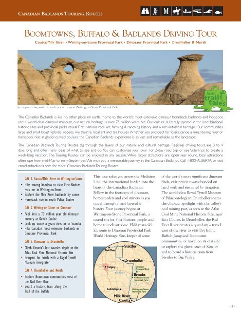
Bo o m t ow n s, Bu f falo & Badla n ds driving to u r<br />
Coutts/Milk River • Writing-on-Stone Provincial Park • Dinosaur Provincial Park • Drumheller & North<br />
Join a park interpreter to visit rock art sites in Writing-on-Stone Provincial Park<br />
The Canadian Badlands is like no other place on earth. Home to the world’s most extensive dinosaur bonebeds, <strong>badlands</strong> and hoodoos<br />
and a world-class dinosaur museum, our natural heritage is over 75 million years old. Our culture is literally layered in the land. National<br />
historic sites and provincial parks reveal First Nations rock art, farming & ranching history and a rich industrial heritage. Our communities<br />
large and small boast festivals, rodeos, live theatre, local art and tea houses. Whether you prospect for fossils, canoe a meandering river or<br />
horseback ride in glacier-carved coulees, the Canadian Badlands experience is as vast and remarkable as the landscape.<br />
The Canadian Badlands Touring Routes dig through the layers of our natural and cultural heritage. Regional driving tours are 3 to 4<br />
days long and offer many ideas of what to see and do. You can customize your own 1or 2-day road trip or use Side Trips to create a<br />
week-long vacation. The Touring Routes can be enjoyed in any season. While larger attractions are open year round, local attractions<br />
often ope from mid-May to early-September. We wish you a memorable journey in the Canadian Badlands. Call 1-800-ALBERTA or visit<br />
<strong>canadian</strong><strong>badlands</strong>.com for more Canadian Badlands Touring Routes.<br />
Day 1. Coutts/Milk River to Writing-on-Stone<br />
• Hike among hoodoos to view First Nations<br />
rock art in Writing-on-Stone<br />
• Explore the Milk River <strong>badlands</strong> by canoe<br />
• Horseback ride in south Police Coulee<br />
Day 2. Writing-on-Stone to Dinosaur<br />
• Peek into a 70 million year old dinosaur<br />
nursery at Devil’s Coulee<br />
• Look up inside a grain elevator at Scandia<br />
• Hike Canada’s most extensive <strong>badlands</strong> in<br />
Dinosaur Provincial Park<br />
Day 3. Dinosaur to Drumheller<br />
• Climb Canada’s last wooden tipple at the<br />
Atlas Coal Mine National Historic Site<br />
• Prospect for fossils with a Royal Tyrrell<br />
Museum interpreter<br />
Day 4. Drumheller and North<br />
• Explore Boomtown communities west of<br />
the Red Deer River<br />
• Board a historic train along the<br />
Trail of the Buffalo<br />
This tour takes you across the Medicine<br />
Line, the international border, into the<br />
heart of the Canadian Badlands.<br />
Follow in the footsteps of dinosaurs,<br />
homesteaders and coal miners as you<br />
travel through a land layered in<br />
history. Your journey begins at<br />
Writing-on-Stone Provincial Park, a<br />
sacred site for First Nations people and<br />
home to rock art some 3500 years old.<br />
En route to Dinosaur Provincial Park<br />
World Heritage Site, keeper of some<br />
of the world’s most significant dinosaur<br />
finds, visit prairie towns founded on<br />
hard work and sustained by irrigation.<br />
The world-class Royal Tyrrell Museum<br />
of Palaeontology in Drumheller shares<br />
the dinosaur spotlight with the valley’s<br />
coal mining past, as seen at the Atlas<br />
Coal Mine National Historic Site, near<br />
East Coulee. In Drumheller, the Red<br />
Deer River creates a quandary – travel<br />
west of the river to visit Dry Island<br />
Buffalo Jump and Boomtown<br />
communities; or travel on its east side<br />
to explore the ghost town of Rowley<br />
and to board a historic train from<br />
Stettler to Big Valley.<br />
- 1 -
Canadian Badlan d s To u r i n g ro u T e s<br />
Visitor Information Centres<br />
Brooks - 6 km east of Brooks on Highway 1<br />
403-362-6881, brookschamber.ab.ca<br />
Milk River - 1 km south of Milk River<br />
on Highway 4 1-800-ALBERTA,<br />
travelalberta.com<br />
Drumheller - 60 1Avenue West<br />
1-866-823-8100, traveldrumheller.com<br />
Stettler - 6606-50th Avenue<br />
1-877-742-9499, stettler.net<br />
Accommodations<br />
Visit the Alberta Hotel & Lodging<br />
Association online at explorealberta.com<br />
for approved accommodation or contact<br />
1-800-ALBERTA.<br />
Camping: Writing-on-Stone, Dinosaur,<br />
Kinbrook Island and Drumheller campgrounds<br />
are often full by early afternoon.<br />
Reservations highly recommended. Camping<br />
at various municipal campgrounds on<br />
the Boomtown Trail (Highway 21) and<br />
Trail of the Buffalo (Highway 56) and at<br />
Tolman Bridge east of Trochu and Bleriot<br />
Ferry on the Red Deer River.<br />
Bed & Breakfasts/Guest Ranches/Hotels:<br />
Numerous in the Drumheller Valley,<br />
Brooks and Red Deer area; limited tourist<br />
accommodation in Milk River area.<br />
Distances and Driving Times<br />
Milk River to Writing-on-Stone,<br />
45 km, 30 min<br />
Writing-on-Stone to Dinosaur,<br />
200 km, 2 hr<br />
Brooks to Dinosaur, 48 km , 30 min<br />
Brooks to Drumheller, 140 km, 1 hr 20 min<br />
Brooks to East Coulee, 122 km , 1 hr 10 min<br />
Drumheller to Big Valley, 70 km, 40 min<br />
Drumheller to Stettler, 95 km, 55 min<br />
This map is not intended for navigation.<br />
Pick up an official Alberta Road Map at a<br />
Visitor Information Centre or call<br />
1-800-ALBERTA.<br />
Events<br />
April<br />
Easter Farmer’s Market, Drumheller<br />
Spring Festival, East Coulee<br />
Rodeo, Stettler, Big Valley<br />
County Music Jamboree, Stettler<br />
June<br />
Beethoven in the Badlands, Drumheller<br />
Craze Daze, Stettler<br />
Warner Days<br />
Writing-on-Stone National Aboriginal Day<br />
Rodeo, Brooks<br />
July<br />
Canada Day Celebrations, all communities<br />
Motorcycle Rally, Wayne<br />
Passion Play, Drumheller<br />
Prairie Wind Sailing Regatta, Brooks<br />
RCMP Musical Ride, Stettler<br />
A Writing-on-Stone<br />
403-647-2364, cd.gov.ab.ca<br />
B Devil’s Coulee Museum<br />
403-642-2118, devilscoulee.com<br />
C Brooks Aqueduct<br />
403-362-4451, cd.gov.ab.ca<br />
D Dinosaur<br />
403-378-4344, cd.gov.ab.ca<br />
The Canadian Badlands Touring Routes aim to follow good secondary highways and, occasionally, offer gravel-road alternatives. While most attractions are accessible on hard-surfaced roads, some have<br />
gravel-road access. Please drive carefully and respect private property. Every effort has been made to ensure accurate information at the time of publication. Attraction hours and seasons of operation vary.<br />
You are advised to contact each attraction in advance. This publication is for information purposes only. We are unable to accept responsibility for any inconvenience, loss or injury sustained as a result of<br />
anyone relying upon this information.<br />
E<br />
F<br />
7<br />
Attractions<br />
East Coulee School Museum<br />
403-822-3970, albertaheritage.net<br />
Atlas Coal Mine<br />
403-822-2220, atlascoalmine.ab.ca<br />
Royal Tyrrell Museum<br />
403-823-7707, tyrrellmuseum.com<br />
H Morrin Sod House, 403-772-2180<br />
I St. Ann Ranch<br />
1-888-442-3924, stannranch.com<br />
J Dry Island Buffalo Jump<br />
403-378-4342, cd.gov.ab.ca<br />
K Anthony Henday Museum<br />
403-749-2711, albertaheritage.net<br />
L Alberta Prairie Railway Excursions<br />
1-800-282-3994, absteamtrain.com<br />
- 2 -
Canadian Badlan d s To u r i n g ro u T e s<br />
1Day<br />
One<br />
Coutts/Milk River to Writing-on-Stone<br />
Provincial Park<br />
Journey from the US-Canada<br />
border across a vast prairie<br />
landscape to a sacred site of the<br />
First Nations people, Writing-on-<br />
Stone. Join a park interpreter to<br />
see ancient writings on sandstone<br />
cliffs and experience the spirited<br />
Milk River Valley by canoe, foot or<br />
on horseback.<br />
Head north from Coutts on Highway 4 or<br />
east from Milk River on Highway 501 to<br />
begin this journey in the Canadian<br />
Badlands. The prairie landscape that<br />
stretches before you is home to the last of<br />
Alberta’s huge ranches, relics of cattle<br />
barons and English investors who came<br />
West in the 1880s seeking freedom and<br />
fortune. Few fences cross these rangelands<br />
where native grasses must be managed<br />
carefully in a land with little water. Yet 75<br />
million years ago, you would have been<br />
standing on the bottom of the warm and<br />
shallow Bearpaw Sea, squeezing sand and<br />
silt between your toes. Insects and frogs<br />
darted among ferns and horsetails in a<br />
swampy land, while birds and flying reptiles<br />
chattered and swooped above forests of<br />
conifers and other huge trees. Dinosaurs<br />
shook the ground, as they stomped along<br />
searching for an easy meal.<br />
The Bearpaw Sea and rivers running into<br />
it laid down layers of sand and silt. Over<br />
time and under great weight and pressure,<br />
beach sands turned into white and golden<br />
sandstone while silty mud formed darker<br />
bands of rock. A million or so years of<br />
erosion by water and wind carved away<br />
at these layers, sculpting unusual<br />
geological formations found across the<br />
Canadian Badlands – hoodoos, coulees,<br />
cliffs, buttes and mesa.<br />
You can check out replicas of one of these<br />
geological curiosities – hoodoos – at the<br />
Travel Alberta Visitor Information Centre,<br />
just south of Milk River. For the real thing,<br />
continue east on Highway 501 for 30 km<br />
to Highway 500. Turn sourth and con-<br />
tinue to Writing-on-Stone Provincial Park.<br />
En route you will cross Verdigris Coulee,<br />
a small gully that joins the Milk River<br />
near the park. There are numerous coulees<br />
across the Canadian Badlands, breaking<br />
up the prairie landscape. Coulees, from<br />
the French word couler meaning to flow,<br />
are gullies and furrows in the hillsides<br />
View First Nations rock art at Writing-on-Stone<br />
:"<br />
originally created by glacial metlwaters.<br />
The largest are 13,000 years old, but the<br />
process continues today.<br />
Help preserve rock art and hoodoos for<br />
future generations. Take only pictures and<br />
leave only footprints – on the main trails.<br />
Do not climb the hoodoos.<br />
Writing-on-Stone is a magical place.<br />
The prairie gives way to the Milk River<br />
Valley abruptly, and a hauntingly beautiful<br />
landscape of sandstone cliffs and<br />
castellated hoodoos appears before you.<br />
Spires of rock that appear to grow from<br />
the valley bottom are the most exemplary<br />
hoodoos in the Canadian Badlands.<br />
A hard rock forms the cap of the hoodoo,<br />
sheltering the softer rock beneath from the<br />
chiseling action of rain and wind. At least<br />
for a while. Hoodoos are the creations of<br />
erosion. Once the cap rock falls, the pillar<br />
shrinks rapidly.<br />
This valley has long been considered<br />
sacred to the First Nations people of the<br />
plains. Dating back at least 3500 years,<br />
the ancestors of the Shoshoni, Gros<br />
Ventre, Blackfoot and other tribes<br />
travelled here to conduct ceremonies<br />
and rituals and to seek spiritual guidance.<br />
In First Nations spirituality, all things<br />
– from rock and water to beaver and bird<br />
– possess a spirit, including this valley.<br />
People came, and still come, to pray for<br />
guidance in this sacred place.<br />
Pictographs painted on the sandstone<br />
cliffs and petroglyphs carved into the rock<br />
are shrouded in mystery and spirituality.<br />
The Blackfoot people believe that the<br />
images were created by the spirits.<br />
- 3 -
Canadian Badlan d s To u r i n g ro u T e s<br />
Archaeologists propose that some<br />
images may have recorded the spirit<br />
dreams of young warriors on vision<br />
quests, and were carved with antler or<br />
bone. While some images appear to tell<br />
the story of a battle or hunt, others have<br />
no obvious explanation. Humans and<br />
animals are depicted in different styles,<br />
likely from different time periods.<br />
Most of the rock art is found in the<br />
Archaeological Preserve. A park bus tour<br />
to the petroglyphs and pictographs should<br />
not be missed. You can find more rock<br />
art along the self-guided Hoodoo<br />
Interpretive Trail and in the Backcountry<br />
Hiking Zone. The latter requires a fording<br />
of the river – check with park staff for<br />
water levels and safe crossing points.<br />
Also across the river is the Writing-on-<br />
Stone Police Outpost at the mouth of<br />
Police Coulee in the park reserve.<br />
The park occasionally offers guided<br />
hikes to the outpost.<br />
Writing-on-Stone and the surrounding<br />
area has lots to offer: guided bus tours<br />
Hike among hoodoos at Writing-on-Stone<br />
:"<br />
and hikes to rock art sites, self-guided trails<br />
through the hoodoos, exhibits in the<br />
Interpretive Centre, wildlife viewing and<br />
birding in unique riparian habitat,<br />
horseback riding in south Police Coulee,<br />
and canoe and raft trips on the Milk River.<br />
The Milk River Valley, with the large<br />
coulees feeding into it from both the north<br />
and south, was a First Nations highway for<br />
thousands of years. Hunters and warriors<br />
passed through as they searched for their<br />
quarry; whisky traders and cattle<br />
rustlers later adopted these well-worn<br />
trails. Mounties charged with bringing<br />
peace and sovereignty to the West<br />
established their outpost at Police Coulee<br />
in 1887. It was part of a chain of posts<br />
along the Canada-US border.<br />
Many outposts were only a tent but some<br />
were more permanent and substantial.<br />
The police officers had a list of duties:<br />
control raiding of horses and cattle, collect<br />
customs duties, stop any whisky smuggling,<br />
and prevent American cattle from ranging<br />
Explore Writing-on-Stone's unique landscape<br />
into Canada. As well, they fought prairie<br />
fires, checked in on settlers, and carried<br />
the mail. Life was lonely at the outposts<br />
and many men deserted. Some left<br />
petroglyphs of their own. Contact the park<br />
Visitor Centre for information on guided<br />
hikes to the restored NWMP outpost.<br />
In the evenings as the hoodoos glow pink<br />
and the little brown bats and nighthawks<br />
hunt overhead, it is easy to believe that<br />
spirits still walk this valley. Camp in the<br />
park or stay in one of the few guest ranches<br />
or bed & breakfasts in the Milk River area.<br />
Alternatively, Lethbridge offers a range of<br />
tourist accommodation, 135 km northwest<br />
on Highways 501 and 4.<br />
- 4 -
Canadian Badlan d s To u r i n g ro u T e s<br />
2Day<br />
Two<br />
Writing-on-Stone to Dinosaur<br />
Provincial Park<br />
Dinosaurs play the starring role in<br />
a visit to Devil’s Coulee and World<br />
Heritage Site Dinosaur Provincial<br />
Park. Breath-taking scenery,<br />
unearthly rock formations and cool<br />
cottonwoods promise a day or<br />
more of discoveries for everyone.<br />
Enjoy the park by foot or on an<br />
interpretive bus tour.<br />
Today’s journey begins by making your<br />
way to the town of Warner, located at<br />
the junction of Highways 4 and 36<br />
(64 km from Writing-on Stone, 18 km<br />
from Milk River and 67 km from<br />
Lethbridge). Warner is a farming<br />
community, known for the discovery<br />
of the first dinosaur eggs in Alberta.<br />
Visit the Devil’s Coulee Dinosaur<br />
Museum to see a replica of the dinosaur<br />
nursery discovered in a coulee not far<br />
from town. For the real thing, join a<br />
museum interpreter on a 2-hour tour of<br />
the Hadrosaur (duckbill) nesting site.<br />
From Warner, follow Highway 36 north.<br />
Highway 36 crosses some of the most<br />
productive farmland around. Watch for<br />
fields of famous Taber sweet corn, as<br />
well as potatoes, beans and sugar beets.<br />
Alberta’s only sugar factory in Taber<br />
depends upon the beets grown in the area<br />
since 1900. Harvesting the riches of the<br />
soil is ever challenging, and, in the early<br />
years, was back-breaking work.<br />
Imagine traveling by horse-drawn wagon<br />
– struggling through steep-sided coulees,<br />
repairing broken harness or worse, a<br />
broken wheel – to arrive at your new<br />
home. Nothing fancy, in fact, probably<br />
nothing at all, just open prairie, 160 acres<br />
(65 hectares) with your name on it.<br />
Here, as in many places across the<br />
Canadian Badlands, the faint of heart<br />
lasted a year or less, beaten by the<br />
relentless wind, harsh winters and<br />
never-ending work. Those who stayed<br />
built a sod house or shack to live in<br />
then a proper wooden house when their<br />
crops prospered.<br />
Along with a house, settlers needed<br />
water. Some settled near Taber and the<br />
Oldman River, while others settled near<br />
the Bow, establishing communities such<br />
as Scandia, Rainier and Bow City.<br />
Successful crops required successful<br />
irrigation and water was transported<br />
to farmland. Irrigation remains just as<br />
important today. As you travel north on<br />
Highway 36 to Brooks, look for signs of<br />
irrigation: reservoirs and canals leading to<br />
farmlands and their pivot sprinklers.<br />
Visit prairie towns sustained by irrigation<br />
You can learn more about the importance<br />
of irrigation at a number of local<br />
attractions: the Taber & District<br />
Museum in Taber, Eastern Irrigation<br />
District Historical Park in Scandia, and<br />
Brook Aqueduct National Historic Site,<br />
southeast of Brooks. You can also reap<br />
the recreational benefits of irrigation at<br />
the many reservoirs in the area: you can<br />
birdwatch, sail, fish, or just enjoy the sun<br />
and sand at Lake Newell and Kinbrook<br />
Island Provincial Park, south of Brooks<br />
on Highway 873.<br />
Dinosaur Provincial Park is 48 km<br />
northeast of Brooks accessed from<br />
Highways 873 and 544. As you<br />
approach the park, the prairie comes<br />
to an abrupt end. Before descending<br />
into the valley, take time to stop at the<br />
lookout where a world truly like no other<br />
stretches before you.<br />
Dinosaur Provincial Park received its<br />
United Nations World Heritage Site<br />
designation for three reasons: the<br />
abundance and diversity of fossils, the<br />
largest and most spectacular <strong>badlands</strong> in<br />
Canada, and to recognize the endangered<br />
river edge habitat with its plains<br />
cottonwood trees.<br />
- 5 -
Canadian Badlan d s To u r i n g ro u T e s<br />
Farmers and ranchers who settled along<br />
the Red Deer River long knew about<br />
strange bones eroding from valley sides.<br />
In 1884, Joseph Tyrell, visited the valley<br />
and came across fossils of what was to<br />
be called an Albertosaurus. This spurred<br />
more exploration, and in 1888,<br />
Thomas Weston of the Geological<br />
Survey unearthed a treasure chest of<br />
fossils at Dead Lodge Canyon, now in<br />
Dinosaur Provincial Park. It wasn’t until<br />
Barnum Brown, a scientist at the<br />
American Museum of Natural History,<br />
visited in 1909 that fossil fever hit. Over<br />
the next five years, the Great Canadian<br />
Dinosaur Rush resulted in the discovery<br />
of more than 200 complete or nearly<br />
complete skeletons.<br />
3Day<br />
Three<br />
Dinosaur Provincial Park to Drumheller,<br />
The Great Canadian Dinosaur Rush<br />
extended from Dinosaur Provincial<br />
Park through the Drumheller Valley<br />
and up the Red Deer River. Close<br />
on the heels of the dinosaur hunters<br />
were coal miners, ranchers and<br />
farmers, all seeking wealth in<br />
prairie soils. Today ou can walk in<br />
their footsteps by prospecting for<br />
fossils and climbing to the top of<br />
a coal mine tipple.<br />
Dinosaur Provincial Park is a giant<br />
laboratory of past life, grudgingly giving<br />
up clues to the researchers who come<br />
here from around the world. At least 35<br />
species of dinosaurs have been found<br />
here, including more than 500 complete<br />
skeletons. Scientists have uncovered<br />
several bonebeds. The climate of the<br />
Bearpaw Sea 75 million years ago was as<br />
explosive as a T. rex. Sudden storms and<br />
flash floods panicked herds of dinosaurs,<br />
drowning large numbers. Sand and mud<br />
washed over the carcasses, burying them.<br />
Over the next three million years, more<br />
sediment poured in, finally covering the<br />
dinosaur graveyards in a rock blanket<br />
1.5 kilometres thick.<br />
Spend the morning further exploring<br />
Dinosaur Provincial Park. If you didn’t<br />
have time yesterday, be sure to take the<br />
2-hour Badlands Bus Tour into the<br />
Natural Preserve. The park has so<br />
much to offer, it’s difficult to leave:<br />
interpretive trails, fossil exhibits, the<br />
John Ware cabin, the exhibits in the<br />
Field Station and birding along the creek<br />
and river. As staff often say, a park that<br />
took over 75 million years to create<br />
deserves more than a day to visit!<br />
Today’s journey begins by making your<br />
way north along Highway 36, north of<br />
Brooks. By the mid-1870s, the endless<br />
grass of the West pulled at the pocket-<br />
books of British and Ontario investors.<br />
With land leased at 1¢ an acre per year,<br />
the potential profits were inviting.<br />
Dukes and princes, lawyers and wealthy<br />
Every year, new discoveries are made.<br />
These fossils are protected in the Natural<br />
Reserve which covers 70% of the park.<br />
You can enter this restricted area on a<br />
guided hike or bus tour. Park interpretive<br />
tours are very popular, so be sure to book<br />
in advance. You can explore the rest of<br />
the park on your own.<br />
Camping at Dinosaur Provincial Park<br />
as the sun paints the <strong>badlands</strong> in hues<br />
of pink and purple is an experience not<br />
to be missed. If you prefer other<br />
accommodation, there is a variety of<br />
hotels and bed & breakfasts in Brooks<br />
and area.<br />
Join a fossil safari in Dinosaur Provincial Park<br />
landowners hired cowboys to trail cattle<br />
from Texas and Mexico to this area. They<br />
placed experienced ranch managers in<br />
charge and waited for the cash to roll in.<br />
Some made a tidy profit; others soon sold<br />
out or abandoned their ranch to invest in<br />
more reliable ventures.<br />
- 6 -
Canadian Badlan d s To u r i n g ro u T e s<br />
Two British dukes owned large parcels of<br />
land north of Brooks, although neither<br />
ever lived here. Their four royal ladies<br />
are remembered in the towns along<br />
Highways 550 and 554. Rosemary was<br />
the daughter of the Duke of Sutherland<br />
and Millicent was his wife. Duchess<br />
commemorates the wife of the Duke of<br />
Connaught who also served as Canada’s<br />
Governor General from 1911 to 1916.<br />
Patricia was their daughter.<br />
Turn north on Highway 36 just past<br />
Duchess. The next 100 km run through<br />
ranching country. Running cattle on the<br />
open range made good business sense to<br />
early ranchers: the grass was good, cattle<br />
walked to rivers for water and cowboys<br />
were needed only for the spring and fall<br />
round ups and to occasionally check<br />
on the cattle. Chinooks kept the snow<br />
off the grass, at least until the winter of<br />
1906/07. That winter the Chinook winds<br />
stayed silent and thousands of cattle froze<br />
or starved to death. It was a bitter lesson.<br />
Ranchers took to fencing their land to<br />
protect and feed their cattle year round,<br />
and planted crops and stored wild hay in<br />
preparation for each upcoming winter.<br />
With the influx of homesteaders,<br />
ranchers saw their open-range empire<br />
shrink year by year. Homesteaders too<br />
faced disappointment when their farming<br />
practices – learned in areas of higher<br />
rainfall – caused their topsoil to blow<br />
away and their crops to wither. This land<br />
filled with settlers, then emptied almost<br />
as quickly in the first three decades of the<br />
20th century. Unless irrigated, the land is<br />
best suited for grazing cattle, at one<br />
:"<br />
animal for every 40 acres. Successful<br />
irrigation has turned Brooks into a<br />
regional centre for cattle feedlots<br />
and processing.<br />
Farms did thrive in river valleys and<br />
hilly areas of the Canadian Badlands<br />
where more rain fell or snow collected.<br />
The upcoming Red Deer River Valley<br />
was one such place.<br />
Explore the <strong>badlands</strong> by canoe.<br />
The Red Deer River offers a Class 1<br />
(novice) river experience. Contact a<br />
visitor information centre for information<br />
on day and multi-day excursions on the<br />
Red Deer River.<br />
You are in cattle country!<br />
About 80 km north of Brooks on<br />
Highway 36, turn left on Highway 570<br />
and continue 26 km to the descent into<br />
the Red Deer River Valley. At the valley<br />
bottom is the ghost town of Dorothy,<br />
once a prosperous community that<br />
served the needs of surrounding<br />
farmers. Today only one of the original<br />
three grain elevators, the Roman<br />
Catholic and United churches, and a<br />
scatter of boarded up homes and<br />
businesses remain. From Dorothy,<br />
Highway 570 becomes Highway 10,<br />
marking the beginning of the Drumheller<br />
Valley, home to the dinosaurs and a coal<br />
mining legacy.<br />
It was carbon – coal – that Joseph Tyrrell<br />
was searching for when he came to the<br />
valley in 1884. He knew that coal would<br />
power the development of the West.<br />
And for many years it did, as fuel for<br />
steam trains and for home heating.<br />
Today it is still used to produce most<br />
of Alberta’s electricity. The Drumheller<br />
Valley was Alberta’s hotbed for coal<br />
mining from 1911 until the 1950s.<br />
Coal remains visible in the valley.<br />
In fact, every black line traced across<br />
the <strong>badlands</strong> around you is a layer of<br />
coal, marking a time when prehistoric<br />
plants fell into swamps and, with time<br />
and compression, left only their carbon<br />
molecules behind.<br />
Coal mining history comes to life at the<br />
Atlas Coal Mine National Historic Site,<br />
13 km northwest of Dorothy on<br />
Highway 10. Follow signs across the river<br />
to the historic site. The Atlas was the last<br />
mine in the Drumheller Valley to close,<br />
in 1984. A large wooden tipple – the site<br />
of size-sorting shakers and coal storage<br />
bins – dominates the site. You can climb<br />
to the top with a guide and peek into the<br />
8-storey high bins while hearing stories of<br />
underground work, accidents, unions and<br />
Wildfire brand coal. Although there are<br />
no underground tours, you can take<br />
a mantrip ride—the old mode of<br />
transporting miners to the coal face.<br />
- 7 -
Canadian Badlan d s To u r i n g ro u T e s<br />
Explore the Atlas Coal Mine<br />
Allow at least two hours to enjoy the<br />
various interpretive programs, audiotours,<br />
walking trails, and the Atlas’ award-<br />
winning film.<br />
The Atlas’ miners walked to work from<br />
East Coulee, a mining town across the<br />
valley that continues to thrive as a<br />
village of commuters, artists and retirees.<br />
Many old miners’ homes have been<br />
restored as permanent or summer<br />
residences. Retired miners still live<br />
here – look for huge vegetable gardens<br />
that in lean years kept the families fed.<br />
With 3000 people in 1940, East Coulee<br />
sprawled across the valley. The town<br />
prospered with shops, churches and a<br />
6-room school lining the main street.<br />
Today the East Coulee School Museum<br />
presents a fascinating glimpse of life<br />
during the heyday of mining. Join a<br />
museum interpreter to tour the restored<br />
1930s schoolroom and, over tea or a<br />
light lunch at the Willow Tea Room,<br />
look through old mining photos or chat<br />
with a local.<br />
To reach East Coulee, from the access<br />
road to the Atlas, continue 1.5 km on<br />
Highway 10. After visiting the school<br />
museum, continue 13 km, passing the<br />
historic mining towns of Lehigh, Willow<br />
Creek, and Cambria to reach Rosedale.<br />
Rosedale is the last historic mining<br />
town before Drumheller, a mining town<br />
itself. Follow the signs to the Suspension<br />
Bridge, a swaying cable bridge hanging<br />
over the Red Deer River. Cross in the<br />
footsteps of the miners as they walked<br />
to work at the Star Mine on the far side.<br />
After changing from street clothes to<br />
mining clothes in the wash house, the<br />
miners picked up their lamp, battery<br />
and identification tag and headed into<br />
the mine. A coal-dusted sandwich and a<br />
flask of water or tea broke a day of heavy<br />
work with pick and shovel or drill and<br />
coal cutter. After a good 8-hour day, it<br />
was back to the surface and a hot shower<br />
before heading home.<br />
There were always several mines near<br />
each community, creating rivalry but<br />
plenty of employment, especially during<br />
the war years. Towns like Rosedale and<br />
nearby Wayne regularly pitted their<br />
Visit Wayne's famous Last Chance Saloon<br />
SiDE TRiP<br />
Take Highway 10X to Wayne, counting the<br />
eleven bridges over the Rosebud River along<br />
the way.Wayne was once home to 2,000<br />
bachelors and families, miners and shopkeepers.<br />
Hotels, restaurants, boarding houses and stores<br />
thrived while the six mines operated. Once the<br />
mines began to close, people moved to the<br />
next mine that was hiring, often taking their<br />
houses with them. Now only the Last Chance<br />
Saloon in the Rosedeer Hotel remain.<br />
Stop in for a buffalo burger and to see the<br />
photographs and artifacts of a town that died<br />
over 50 years ago. Motorcycle buffs shouldn’t<br />
miss the annual Harley Davidson rally in<br />
early July.<br />
sports teams against each other. After<br />
cheering on their players, they retired to<br />
some friendly drinking and gambling in<br />
the pool halls and bars. If you have time,<br />
one such establishment is the famed Last<br />
Chance Saloon in Wayne.<br />
From Rosedale, continue 5 km to<br />
Drumheller, the heart of Dinosaur<br />
Country and the modern Dinosaur Rush.<br />
Folk art dinosaurs are everywhere and<br />
the big granddaddy stands guard over<br />
the Visitor Information Centre.<br />
Climb to the top of the World’s Largest<br />
Dinosaur for a Tyrannosaurus-eye view of<br />
the <strong>badlands</strong> and the cottonwood-lined<br />
Red Deer River. Then join Alberta’s<br />
dinosaur hunters at the Royal Tyrrell<br />
Museum of Palaeontology.<br />
The Royal Tyrrell is located in Midland<br />
Provincial Park, 6 km northwest of<br />
Drumheller on Highway 838.<br />
The museum promises an educational<br />
- 8 -
Canadian Badlan d s To u r i n g ro u T e s<br />
SiDE TRiP<br />
The Hoodoos Recreation Area is 6 km west<br />
of East Coulee on Highway 10. Like stone<br />
mushrooms that have popped out of the<br />
valley floor, these hoodoos are just some of<br />
the hundreds, large and small, that you can<br />
see throughout the Canadian Badlands. A hard<br />
rock forms the cap of the hoodoo, sheltering<br />
the softer rock beneath from the chiseling<br />
action of rain and wind. At least for a while.<br />
Hoodoos are the creation of erosion. Once the<br />
cap rock falls, the pillar shrinks rapidly. it is<br />
important not to climb on the hoodoos, both<br />
for your safety and theirs.<br />
4Day<br />
Four<br />
Drumheller and North<br />
To summon the words of David<br />
Frost, two roads diverge and sorry,<br />
you cannot travel both. From<br />
Drumheller, you can chose either<br />
to continue north on Highway<br />
56 for a historic train ride from<br />
Stettler to Big Valley, or set out for<br />
the Boomtown communities along<br />
Highway 21 and the remarkable<br />
Dry Island Buffalo Jump.<br />
Option 1: Trail of the Buffalo<br />
This route begins on the North Dinosaur<br />
Trail on the north side of the Red Deer<br />
River in Drumheller. Turn west onto<br />
Highway 838 which quickly leads you<br />
out of town past the Homestead Antique<br />
visit of two to three hours. The high-<br />
light for many visitors is the Dinosaur<br />
Gallery where reconstructed skeletons<br />
tower over you, still threatening after<br />
so many years. The museum’s guided<br />
hikes and interpretive programs are<br />
popular as well. Contact the Tyrrell<br />
in advance to join an interpreter on a<br />
realistic dinosaur dig and to cast your<br />
own dinosaur fossils.<br />
Museum and the Murray House. Stop in<br />
for tea and a muffin, then stroll through<br />
the museum for stories of farmers,<br />
ranchers and miners who settled this<br />
valley. Some of these stories depict<br />
the life of the nearly 2000 miners who<br />
worked at the Midland Mine, now a<br />
provincial park, 2 km further up the road.<br />
The Midland Coal Mining Company<br />
owned 2 of the 140 coal mines that<br />
operated in the valley until 1984.<br />
Take a walk on the 1.1 km interpretive<br />
trail to see some of the equipment used<br />
underground. At the west end of Midland<br />
Provincial Park is the Royal Tyrell<br />
Museum. If you didn’t have time<br />
yesterday to visit the museum, it’s well<br />
worth the stop.<br />
Continuing up river on Highway 838<br />
you pass the Little Church and<br />
attractions such as golf and go-carts.<br />
The road climbs steeply out of the<br />
valley to Horsethief Canyon Viewpoint.<br />
SiDE TRiP<br />
Drumheller can keep you busy for days!<br />
Take time to visit the Homestead Antique<br />
Museum, cuddle up with a boa constrictor at<br />
Reptile World, squeeze into Alberta’s<br />
smallest church, drive the Dinosaur Trail,<br />
via Bleriot Ferry, and shop in historic<br />
downtown Drumheller. Contact the Drumheller<br />
Visitor information Centre for details on these<br />
attractions, as well as where to golf, canoe,<br />
hike and horseback ride in the valley.<br />
Don’t forget to ask about scenic helicopter<br />
rides over Horseshoe Canyon!<br />
Marvel at dinosaurs at the Royal Tyrrell<br />
It’s worth taking a few minutes to stop<br />
and breathe in the striking panorama<br />
before you. The canyons, cliffs and<br />
channels carved by glacial rivers 13,000<br />
years ago were the haunt of horse and<br />
cattle thieves in Drumheller’s early<br />
ranching days. These master thieves<br />
rustled animals further north then hid<br />
them in this rocky maze. Once any<br />
pursuit ended, the thieves trailed the<br />
animals to Montana, USA to<br />
willing buyers.<br />
- 9 -
Canadian Badlan d s To u r i n g ro u T e s<br />
From Horsethief Canyon Viewpoint,<br />
continue north on the Dinosaur Trail.<br />
Highway 838 crosses farmlands to the<br />
junction with the hard-packed Township<br />
Road 302. To the left is access to Bleriot<br />
Ferry, once the only means of crossing<br />
wagons, livestock, and people across the<br />
Red Deer River without getting wet.<br />
The ferry linked neighbours, preventing<br />
the loneliness that often plagued the<br />
isolated farmers. In operation since 1913,<br />
the ferry is a real prairie workhorse.<br />
One of the few left in the province, it<br />
operates from spring break-up (about<br />
May) to fall freeze-up (about October or<br />
November). You can take the ferry and<br />
continue this tour on Option 2,<br />
just north of Orkney Hill Viewpoint.<br />
To continue with Option 1, turn right<br />
on Township Road 302 and drive east<br />
8 km, past Munson to Highway 9. Turn<br />
left and continue north 10 km to the<br />
junction of Highways 9 and 56 where<br />
you turn left to access the village of<br />
Morrin where you can step into a<br />
reconstructed “soddie”. The town is<br />
5 km east of Highway 56, just north<br />
off Highway 9.<br />
Imagine that it’s 1910 and you have<br />
arrived by wagon to homestead on the<br />
prairie. Your first task: build a house<br />
where wood is scarce and sawmills far<br />
away. Like your neighbours, your first<br />
home is a “soddie” built from fresh sod<br />
turned by the plow. These sods were<br />
cut into large, brick-like sections and<br />
stacked. The roof was a series of angled<br />
poplar poles covered with more sod.<br />
As to the floor, it was simply dirt.<br />
On hot days the house was cool, and on<br />
cold days, warm. It remained dry during<br />
a short rainstorm but could rain inside<br />
for several days afterwards!<br />
Homesteaders used this technique to<br />
build barns for their animals and storage<br />
sheds. The buildings lasted until they<br />
could afford sawn lumber. After visiting<br />
Morrin Sod House, return to<br />
Highway 56 – part of the Alberta<br />
Trail of the Buffalo – and continue<br />
north towards Stettler.<br />
Settlement in this vast land depended<br />
on the ability of settlers to reach their<br />
homesteads. Most arrived by rail in<br />
Calgary and, eventually, Stettler. From<br />
Calgary, homesteaders packed all their<br />
belongings in a horse-drawn wagon and<br />
followed rutted trails east. They had to<br />
cross the Red Deer River, a feat in itself.<br />
Once the first ferry was established east<br />
of Trochu at Tolman in 1907, settlement<br />
boomed. Villages like Morrin, Rowley<br />
and Rumsey became the social and<br />
commercial hearts of their districts.<br />
Rowley was once a booming community;<br />
now it is largely a ghost town with a<br />
Imagine life as an early settler at Morrin Sod House<br />
mixture of restored buildings and those<br />
left to the whim of time. Rowley is 13 km<br />
north of Morrin, accessed from Highway<br />
56 on gravel Township Road 324.<br />
Walk the main street past Sam’s Saloon,<br />
the hardware store and the pool hall to<br />
the train station. The tracks are now<br />
gone but a gust of wind whistling around<br />
the corner of the Yesteryear Artifacts<br />
Museum suggests better days when the<br />
train brought mail, freight and passengers<br />
to the crowd of farmers and ranchers<br />
waiting on the platform. Periodically,<br />
movie producers discover Rowleywood’s<br />
charm and film movies and commercials,<br />
often using locals for extras. Rowley’s<br />
businesses and museum open daily in the<br />
summer months and the last Saturday<br />
night of every month is pizza night.<br />
As you travel north on the Trail of<br />
the Buffalo notice how the land has<br />
become hillier. Several ice ages have<br />
sent their glacial tongues scouring this<br />
landscape from north to south. As the<br />
climate warmed, these ice sheets melted<br />
and dropped their loads of boulders and<br />
gravels. The knobs, or kames, left behind<br />
are covered with grass while the hollows,<br />
or kettles, often collect water, attracting<br />
waterfowl and migrating birds.<br />
This knob and kettle landscape is set in<br />
the last remaining tract of aspen parkland<br />
in Canada, and is part of the Rumsey<br />
Provincial Ecological Reserve &<br />
Natural Area. The land is managed in<br />
conjunction with leaseholders, and it<br />
is a courtesy to contact them if you are<br />
interested in walking on the land.<br />
- 10 -
Canadian Badlan d s To u r i n g ro u T e s<br />
Thirty kilometers north of Rowley, just<br />
west of Highway 56, is Big Valley, a<br />
town that managed not to drift away<br />
with the prairie wind. Originally<br />
established as a coal mining town, it was<br />
the railway that attracted settlers and<br />
businesspeople, alike. Railway workers<br />
moved into town when it was named<br />
a terminal and a roundhouse was built.<br />
The boom didn’t last long – competing<br />
railways merged under the Canadian<br />
Northern Railway and traffic and railway<br />
workers were diverted elsewhere. More<br />
residents were lost when a branch from<br />
Hanna to Mirror opened, by-passing<br />
Big Valley. Yet it is the railway once<br />
again that is bringing people to town.<br />
Alberta Prairie Railway Excursions<br />
offers scenic train rides to Big Valley.<br />
Departing from Stettler, 32 km to the<br />
north, this leisurely, rocking ride chugs<br />
through vibrant parkland and farmland.<br />
You may meet Gabriel Dumont, a leader<br />
of the Riel Rebellion from Saskatchewan,<br />
take part in a murder mystery, or be a<br />
victim of an old-fashioned train robbery.<br />
At the stop in Big Valley, you will have<br />
time to walk the interpretive trail at the<br />
roundhouse, visit the Canadian Railway<br />
Hall of Fame in the restored train<br />
station, climb to bright blue St. Edmund’s<br />
Church and shop at Jimmy Jock<br />
Boardwalk. The train tours last between<br />
four and eight hours, with lunch or<br />
dinner included. Be sure to book ahead.<br />
If you would like to see history rather<br />
than be part of it, Stettler’s Town and<br />
Country Museum shows every aspect<br />
of local history in 26 buildings. You can<br />
browse through historic homes and<br />
shops, learn a lesson at the schools, ride<br />
a speeder at the CN station or check the<br />
engines of restored tractors. One of the<br />
museum guides might even tell you about<br />
Stettler’s cigar factory! You can also head<br />
to downtown Stettler; the main street is<br />
lined with relics from its boomtown past.<br />
Be sure to pick up a copy of the town’s<br />
historic walking tour.<br />
From Stettler you can continue west<br />
to the City of Red Deer on Highways<br />
12 and 11 or take Highway 12 east to<br />
explore more Trail of the Buffalo<br />
communities. The trail also extends<br />
north on Highway 56; be sure to visit<br />
Donalda, a small town set along the<br />
rugged Meeting Creek Coulee.<br />
The Donalda Gallery for the Arts,<br />
located in the historic Imperial Bank<br />
of Canada feature local artisans, and<br />
the Donalda Museum is home to 850<br />
different types of kerosene lamps.<br />
Option 2: Boomtown Trail<br />
This route begins on the South Dinosaur<br />
Trail on the south side of the Red Deer<br />
River in Drumheller, passing the old<br />
mining towns of Kneehill and Nacmine.<br />
Seven kilometers past Kirkpatrick,<br />
turn right on Highway 837 to cross the<br />
river and climb steeply out of the valley<br />
to reach Orkney Hill Viewpoint.<br />
The Viewpoint offers a spectacular<br />
panorama of the Red Deer Valley<br />
Badlands. Take time to breathe in<br />
the view!<br />
Enjoy the the historic train ride from Stettler<br />
to Big Valley<br />
Continue north on Highway 837 to<br />
Highway 27. Turn left and follow the<br />
road west for 18 km to Highway 21 and<br />
the Boomtown Trail. Many of the towns<br />
and villages on Highway 21 sprang up<br />
quickly during the heyday of settlement<br />
in the early 1900s. Today, towns like<br />
Lousana, Elnora and Huxley have few<br />
shops or services, but almost a hundred<br />
years ago their business districts bustled!<br />
Banks, stores, lumber yards and barber<br />
shops vied for space and attention.<br />
The owners faced their small and simple<br />
wooden buildings with a grand, square-<br />
topped front to appear larger and more<br />
significant. This building style, common<br />
to Western movies, has the descriptive<br />
name of boomtown architecture. Stroll<br />
down the main street of any Boomtown<br />
community and you will see several<br />
examples – some restored and some<br />
leaning towards better days.<br />
The first Boomtown community on this<br />
route is Three Hills, 7 km north from the<br />
junction of Highways 27 and 21. As in<br />
many prairie towns, grain elevators line<br />
the railway in Three Hills. Many of these<br />
- 11 -
Canadian Badlan d s To u r i n g ro u T e s<br />
prairie sentinels were built in the wheat<br />
boom of the 1920s, perched next to the<br />
rail line that would link small towns to<br />
far-flung markets. By the mid-1930s,<br />
Alberta boasted over 1,700 elevators.<br />
Now there are a mere few hundred left.<br />
Many elevators have been torn down<br />
as rail lines closed and grain companies<br />
built concrete and metal silos in larger,<br />
regional centres. You can view the new<br />
and the old in grain elevator architecture<br />
in Three Hills. Over tea in the restored<br />
train station at the Kneehill Historical<br />
Museum, look through photos of early<br />
days in Three Hills.<br />
From Three Hills, return to Highway 21<br />
and continue north 13 km to Trochu.<br />
Trochu’s main street reflects the booms<br />
and busts of prairie towns. Some classic<br />
boomtown relics remain: squared-topped<br />
front stores and a stately brick building<br />
line the wide street, and the grain<br />
elevators frame the view down main<br />
street and out of town. At the turn of<br />
the century, promises of easy wealth and<br />
freedom attracted settlers from eastern<br />
Canada, England, America, Denmark,<br />
Germany and many other countries.<br />
Trochu, however, has roots in the<br />
Brittany area of France.<br />
In 1905, Armand Trochu and two<br />
partners set out to develop the St. Ann<br />
Ranch and Trading Company.<br />
Their enterprise was successful and<br />
rapidly attracted other families.<br />
A school and hospital followed, run<br />
by the French Sisters of Charity of our<br />
Lady of Evron.<br />
:"<br />
By 1911 and the arrival of the railway,<br />
Trochu was thriving with businesses<br />
where French was as likely to be spoken<br />
as English. When the First World War<br />
broke out, most of the settlers returned<br />
to France to fight – few ever saw Canada<br />
again. Stop in for tea at St. Ann Ranch,<br />
a provincial historic site, and stroll<br />
among the post office, school and chapel.<br />
As you return to Highway 21 and<br />
continue north, you will pass the<br />
community of Huxley. It was the people<br />
of Huxley and area who valued a stretch<br />
of the Red Deer River enough to lobby<br />
the Province for its protection as a park.<br />
As a result, you can enjoy the remarkable<br />
Dry Island Buffalo Jump Provincial Park.<br />
Breathe in the view at Dry Island Buffalo Jump<br />
Explore the Red Deer River Valley on<br />
horseback. Contact 1-800-ALBERTA for<br />
details on working and guest ranches<br />
near Dry Island Provincial Park and in the<br />
Drumheller Valley.<br />
Two kilometers north of Huxley, turn<br />
east on Township Road 344 and<br />
continue 20 km east on a good gravel<br />
road to reach the edge of the Red Deer<br />
River Valley. At the park entrance is Dry<br />
Island Viewpoint; below lies a stunning<br />
landscape of hoodoos, gray hillsides<br />
scored by rainwater, sandstone cliffs and<br />
the silty Red Deer River. Walk to the<br />
interpretive panels at the edge of the<br />
grassy bench. To your left is the “dry<br />
island”, a mesa separated from the valley<br />
edge; look right and you will see the<br />
grassy cliff-top of a buffalo jump.<br />
Bison herds once travelled these plains,<br />
finding abundant grasses, water and<br />
shelter in the coulees. These immense<br />
animals were a grocery store on the hoof<br />
for the Cree people, and it was here that<br />
the Cree hunted by stampeding bison<br />
over the steep cliffs. Unlike other buffalo<br />
jumps in Alberta, the steep cliffs at<br />
Dry Island assured that the bison died<br />
on impact. A successful hunt secured<br />
meat for pemmican, hides for tipis and<br />
horns for cups. Archaeologists and local<br />
ranchers and farmers have unearthed<br />
stone tools, fire pits, pottery shards and<br />
bone fragments.<br />
From the Dry Island Viewpoint, you can<br />
descend on the park road to the picnic<br />
area near the river. Unofficial trails lead<br />
in several directions; look for wildflowers<br />
and fossils, leaving them untouched for<br />
future visitors.<br />
- 12 -
:"<br />
Canadian Badlan d s To u r i n g ro u T e s<br />
See a Fossil? Let it Be!<br />
Fossils uncover stories of past times when<br />
left on the ground with other fossils and<br />
rocks. Mark the spot and report it to the<br />
Tyrrell Museum so a palaeontologist can<br />
check it out. Collecting fossils in Alberta is<br />
illegal without a permit.<br />
As you continue north on Highway 21,<br />
you enter aspen parkland country, a<br />
natural mosaic of aspen forest and<br />
grassland. In southern parts of the<br />
Canadian Badlands, early setttlers could<br />
begin to break the land immediately; in<br />
the parkland, trees had to be cut down<br />
and the roots removed first. Farmers first<br />
settled any open grassland, their efforts<br />
From dinosaurs to coal mining and the lazy Red Deer River to Boomtown communities, this <strong>touring</strong> route has<br />
given you a taste of the Canadian Badlands. More discoveries await. In the Canadian Badlands, you can search<br />
for orchids in the Cypress Hills, watch rare birds at Pakowki Lake, paddle a voyageur canoe in Medicine Hat or<br />
enjoy afternoon tea at a number of tea houses, and take in local rodeos, farmers’ markets and festivals in<br />
communities across the region. To plan your next Canadian Badlands experience, go to <strong>canadian</strong><strong>badlands</strong>.com<br />
or contact Travel Alberta at 1-800-ALBERTA.<br />
ending at the edge of the forest. Slowly,<br />
with horse teams, chains, dynamite and<br />
axes, they ate into the forest edges.<br />
Not until tractors became affordable<br />
after the Second World War did much<br />
of the parkland come under<br />
cultivation. To imagine life as a settler,<br />
step into a replica homesteader’s shack<br />
at the Anthony Henday Museum in<br />
Delburne. An extensive collection of<br />
pioneering artefacts is housed in the old<br />
train station and water tank tower.<br />
After your visit to Delburne, continue<br />
north on Highway 21, reaching<br />
Highway 12 in about 20 km.<br />
From Delburne, you can follow<br />
Highway 11 west to the City of<br />
Red Deer or continue north on the<br />
Boomtown Trail to Camrose. If you are<br />
heading north, you can camp, swim,<br />
canoe and fish at Rochon Sands<br />
Provincial Park, a Watchable Wildlife<br />
site. Keep an eye out for pelicans flying<br />
overhead as they leave their summer<br />
haunts on the water and islands of<br />
Buffalo Lake to fish and loaf on the<br />
Red Deer River.<br />
Visit the Hoodoos, near Drumheller Roar from the mouth of the world's largest Dinosaur Canoe the calm Red Deer River<br />
- 13 -
Boomtowns, Buffalo,<br />
and Badlands<br />
Take a thrilling train ride, pretend you’re a<br />
cowboy, dig in dirt like a paleontologist, and<br />
travel the trail of the buffalo on this exciting<br />
tour.<br />
Writing-on-Stone Provincial Park:Take an<br />
interpretive tour to see ancient Aboriginal rock art<br />
of people, animals, and the stories of Aboriginal<br />
culture. Cool down in the park with some swimming,<br />
fishing, canoeing, and kayaking.<br />
Warner:At the Devils Coulee Dinosaur Heritage<br />
Museum, peek at fossilized baby dinosaurs and the<br />
eggs of the Hadrosaur Dinosaur. Stick your fingers<br />
in cool plaster and make a cast of a dinosaur<br />
footprint! Be an official Dino-digger and scoop<br />
up dirt to reveal a dinosaur bone bed. On the<br />
Devils Coulee Guided Tour step into the heart of<br />
the Dinosaur world to see fossils still in the earth.<br />
BROOKS AND AREA:<br />
Lake Newell/Kinbrook Island Provincial Park:<br />
Build a sandcastle, jump into one of Alberta’s<br />
warmest lakes for a swim, or try your luck at<br />
Need a Break?<br />
fishing! Visit the Brooks Lakeside Leisure Centre<br />
where you can zip down a waterslide or cannon ball<br />
into the pool.<br />
DRUMHELLER AND AREA:<br />
World’s Largest Dinosaur and Spray Park: Look<br />
up…way up to the World’s Largest Dinosaur-climb<br />
151 feet to the top and get a T-rex eye view. On a<br />
hot summer day, splash around the spray park but<br />
beware of the T-rex’s clutches!<br />
The Royal Tyrrell Museum:<br />
Offers programs just for kids<br />
from 45 minutes to 3 hours.<br />
Explore a dinosaur quarry and<br />
play dinosaur games with the<br />
Jr. Dinosaur Explorers, or<br />
discover ancient fossils and<br />
make crafts at the Dino<br />
Adventure Hour.<br />
Reptile World: Squeeze your way into a picture<br />
with Brittany the Boa Constrictor then snap up<br />
some courage to visit Fred the 600 pound alligator!<br />
Reptile World is Canada’s largest reptile exhibit,<br />
located in downtown Drumheller.
Drumheller pools and waterslides: Dash<br />
down a slippery waterslide, or cannonball<br />
into a pool at the Drumheller Aquaplex<br />
next to the World’s Largest Dinosaur.<br />
Don’t forget to see if your hotel has a<br />
swimming pool or a waterslide!<br />
Atlas Coal Mine National Historic Site:<br />
Have you ever wondered what a real mine<br />
looks like? Take a teeth-chattering coal<br />
car ride, climb the wooden tipple and learn<br />
how coal was taken from the ground, sorted,<br />
and shipped off to market.<br />
Three Hills<br />
Zip on down to the Three<br />
Hills Aquatic Centre for<br />
some waterslide and swimming<br />
fun. Then travel just<br />
outside of Three Hills to<br />
the Guzoo Animal Farm<br />
(located just off secondary<br />
highway 583) and meet<br />
over 400 animals! You can<br />
pet a real lion cub and watch the<br />
feeding time with all the animals.<br />
Big Valley<br />
The old west is right around the corner at<br />
the Jimmy Jock Boardwalk. Creak along<br />
the western style boardwalk and visit an<br />
old barbershop. Stop your tummy from<br />
rumbling at the fudge factory or have one<br />
of Vivian’s famous sticky cinnamon buns at<br />
Hulley’s Hideway Café.<br />
Stettler<br />
Jump aboard a real steam or diesel train<br />
with Alberta Prairie Railway Excursions.<br />
Take part in one of the family tours and<br />
have fun with clowns and a sing along!<br />
Watch out for the dreaded Bolton Gangthis<br />
gang of dressed up actors like to rob<br />
trains and take your money! Luckily, you’ll<br />
have the famous buffalo hunter Gabriel<br />
Dumont on the train who will help save you<br />
from the robbers! Once your train ride<br />
has ended, zip down a waterslide at the<br />
Stettler Recreation Centre.<br />
Fill in the answers on the blanks and<br />
then put the letters together to spell<br />
a secret word!<br />
1. The Royal Tyrrell _______<br />
2. The _____ Jock Boardwalk<br />
3. Jump aboard a steam or diesel _____<br />
in Stettler<br />
4. Be a Dino- ______ in Warner<br />
5. Get a ____ eye view at the World’s<br />
Largest Dinosaur and Spray Park<br />
A _______ is a worker who finds coal and other elements deep underground and takes them out of<br />
Earth. Many fossils were discovered when looking for coal in the hills of the <strong>badlands</strong>. You can imagine<br />
what it was like to be a miner at the Atlas Coal Mine National Historic Site.<br />
Secret Word is MINER
Canadian Badlan d s To u r i n g ro u T e s<br />
To u r i n g ro u T e s Feedback Fo rm<br />
We hope you enjoyed your driving tour of the Canadian Badlands. To help us improve the self-guided tour experience, please<br />
take time to complete and return this form. To thank you for your time, we would like to send you a complimentary poster<br />
of Dinosaur Provincial Park.<br />
1. Please indicate the driving tour you participated in:<br />
O Prairie Winds & Badlands (Lethbridge, Cypress Hills and Medicine Hat)<br />
O Red Coats & Coulees (Medicine Hat/Walsh, Cypress Hills and Dinosaur Provincial Park)<br />
O Train Tales & Dinosaur Trails (Oyen, Hanna, Drumheller and Dinosaur Provincial Park)<br />
O Homesteads, Bonebeds & Coalbeds (Calgary, Drumheller and Dinosaur Provincial Park)<br />
O Boomtowns, Buffalo & Badlands (Milk River/Coutts, Writing-on-Stone and Dinosaur Provincial Park and Drumheller)<br />
O Coal Trails & Prairie Rails (Red Deer, Dry Island Buffalo Jump Provincial Park and Drumheller)<br />
2. Please describe your travel party:<br />
Number of adults<br />
Number of children (under 18 years of age)<br />
3. How did you learn about the driving tour?<br />
O Internet (please specify website)<br />
O Travel Alberta Visitor Information Centre (please provide name)<br />
O Community Visitor Information Centre (please provide name)<br />
O Friend or family member<br />
O Other (please specify)<br />
4. Did you participate in the full length of the driving tour as outlined in the self-guided driving tour description?<br />
O Yes<br />
O No If no, indicate which day(s) you participated in: (e.g., day 2)<br />
Why did you choose not to participate in the full driving tour?<br />
5. Check the statements that are most accurate:<br />
O I used the driving tour to plan a trip to the Canadian Badlands.<br />
O I was already planning to visit the Canadian Badlands and used the driving tour as a resource.<br />
O I was already visiting the Canadian Badlands and used the driving tour to enhance my trip.<br />
O I stayed longer in the Canadian Badlands as a result of the driving tour.<br />
O I am planning another trip to the Canadian Badlands as a result of the driving tour.<br />
O Other (please specify)
Canadian Badlan d s To u r i n g ro u T e s<br />
6. After participating in this driving tour, would you consider participating in another Canadian Badlands driving tour?<br />
O Yes<br />
O No. If no, why not?<br />
7. After participating in this driving tour, would you consider participating in a similar self-guided driving tour elsewhere<br />
in the Province of Alberta?<br />
O Yes. If yes, what part of Alberta interests you?<br />
O No<br />
For each of the following questions, please indicate your answer on the scale provided,<br />
where 1 represents very unsatisfied and 5 represents very satisfied.<br />
1. How satisfied were you with the level of information 1 2 3 4 5<br />
in the self-guided driving tour description?<br />
2. How satisfied were you with the accuracy of the 1 2 3 4 5<br />
information in the self-guided driving tour description?<br />
3. How satisfied were you with the number of 1 2 3 4 5<br />
attractions and activities in the driving tour?<br />
4. How satisfied were you with the length of the driving tour? 1 2 3 4 5<br />
Additional Comments<br />
To receive your complimentary poster, please provide the following information (optional). Personal information<br />
collected in this survey is done so in accordance with the Freedom of Information and Protection Act (FOIP).<br />
Last Name: First Name:<br />
Address : City:<br />
Province/State: Country: Postal Code/Zip Code:<br />
Mail: Tourism Development Branch,<br />
Alberta Tourism, Parks, Recreation and Culture,<br />
6th Floor, Commerce Place, 10155 – 102 St.<br />
Edmonton, Alberta, Canada T5J 4L6<br />
Fax: (780) 427-0778