Mongolia - General Mining
Mongolia - General Mining
Mongolia - General Mining

You also want an ePaper? Increase the reach of your titles
YUMPU automatically turns print PDFs into web optimized ePapers that Google loves.
26<br />
4 - Independent Geological Report - <strong>Mongolia</strong><br />
2.0 GEOTECTONIC SETTING AND<br />
REGIONAL GEOLOGY<br />
<strong>Mongolia</strong> is situated at the margin of two cratonal<br />
blocks; the North China Platform to the south<br />
and the Siberian Craton to the north. The region<br />
has experienced major terrain accretion events<br />
throughout the Paleozoic, with subsequent postcollisional<br />
extension giving rise in the Paleozoic<br />
to extensive bi-modal volcanism and associated<br />
intrusion of felsic, calc-alkaline plutons and stocks<br />
(Cunningham, 2007 and Parfenov et al., 2007).<br />
Carboniferous sedimentary deposits are known to<br />
be coal bearing and occur in the south Gobi and<br />
northwestern <strong>Mongolia</strong>, with the northwestern coal<br />
basin extending north into Russia (Sanjsuren, 2008).<br />
The geology of northwestern <strong>Mongolia</strong> is dominated<br />
by events related to the closure of the Tethys Ocean<br />
during the Late Paleozoic to Early Mesozoic (Parfenov<br />
et al., 2007) (Figure 2). The resulting suture zone,<br />
the Mongol-Okhotsk Zone (MOZ), strikes eastnortheast<br />
over approximately 3000 kilometres and<br />
45 ° 50 °<br />
=<br />
Khuden Khuden (Coal) (Coal)<br />
(Coal)<br />
Bayan-Olgii<br />
90 ° 95 °<br />
90 °<br />
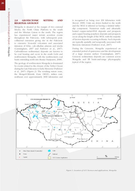
UVS UVS UVS UVS NUUR NUUR NUUR NUUR NUUR NUUR NUUR NUUR NUUR BASIN BASIN PROJECTS<br />
PROJECTS<br />
Ulaangom<br />
Uvs<br />
Khovd<br />
Zavkhan<br />
Khovsgol<br />
KHANGAI KHANGAI KHANGAI KHANGAI KHANGAI KHANGAI KHANGAI FAULT FAULT PROJECTS<br />
PROJECTS<br />
Uliastai<br />
Arkhangai<br />
Govi-Altai<br />
95 °<br />
Mine/Major deposit (Commodity)<br />
Town<br />
Capital<br />
Bayankhongor<br />
Nariin Nariin Nariin Nariin Nariin Nariin Sukhait Sukhait Sukhait Sukhait Sukhait Sukhait Sukhait Sukhait Sukhait Sukhait (Coal) (Coal) (Coal) (Coal) (Coal) (Coal)<br />
(Coal) (Coal) (Coal) (Coal)<br />
Moron Bulgan<br />
Erdenet Erdenet Erdenet (Cu)<br />
(Cu)<br />
Ovorkhangai<br />
M O N G O L I A<br />
Lake<br />
100 °<br />
100 °<br />
Railroad<br />
GCC Licence/Application<br />
Tavan Tavan Tavan Tavan Tolgoi Tolgoi Tolgoi Tolgoi (Coal)<br />
(Coal)<br />
Omnigov<br />
is recognised as being over 200 kilometres wide<br />
(Koval, 1999). Units are down faulted to the north<br />
and the MOZ is inferred as having a sinistral strikeslip<br />
component. Numerous mafic and ultramafic<br />
hosted copper-nickel-PGE deposits and prospects<br />
and copper bearing porphyry deposits and prospects<br />
occur along the length of the MOZ, with the majority<br />
of known deposits occurring in Russia. Such deposits<br />
are typically spatially and temporally associated with<br />
Mesozoic intrusions (Parfenov et al., 2007).<br />
During the Cenozoic, <strong>Mongolia</strong> experienced an<br />
extended period of quiescence and the development<br />
of a large erosion surface (Cunningham, 2007).<br />
Cenozoic sedimentary deposits are common across<br />
<strong>Mongolia</strong> and fill basin-and-range physiography<br />
typical of the region.<br />
105 °<br />
Irkutsk<br />
R U S S I A<br />
Selenge<br />
=<br />
ULAANBAATAR<br />
ULAANBAATAR<br />
Tov<br />
Boroo Boroo Boroo (Au)<br />
(Au)<br />
Dundgov<br />
Tsagaan Tsagaan Tsagaan Tsagaan Tsagaan Tsagaan Tsagaan Tsagaan Tsagaan Suvarga Suvarga Suvarga Suvarga Suvarga (Cu) (Cu) (Cu) (Cu) (Cu) (Cu)<br />
(Cu) (Cu) (Cu) (Cu)<br />
Dornogov<br />
(Cu)<br />
105 °<br />
110 °<br />
Oyu Oyu Tolgoi Tolgoi Tolgoi Tolgoi Tolgoi Tolgoi (Cu-Au)<br />
(Cu-Au)<br />
Khentii<br />
110 °<br />
Chita<br />
Dornod<br />
Sukhbaatar<br />
115 ° 120 °<br />
C H I N A<br />
115 ° 120 °<br />
%<br />
0 500 km<br />
Figure 1: Location of GCC licences and applications, <strong>Mongolia</strong><br />
50 °<br />
45 °