Mongolia - General Mining
Mongolia - General Mining
Mongolia - General Mining

You also want an ePaper? Increase the reach of your titles
YUMPU automatically turns print PDFs into web optimized ePapers that Google loves.
54<br />
5 - Independent Geological Report - Australia<br />
interest were black chlorite schists, limestones and<br />
dolomites. Several quartz-reefs were also noted and<br />
sampled.<br />
Targeted during this visit were the ‘black calcite’<br />
outcrops, which earlier prospecting has found to be<br />
highly anomalous in silver; in particular the ‘black<br />
calcite’ range, which was noted during RW’s 2006<br />
helicopter reconnaissance to persist for over six<br />
kilometres strike length.<br />
The independent geologist was able to follow this<br />
feature on the ground and to sample it over 1,500<br />
m length. He found that it was indeed open in both<br />
the north and the south. He has formed the opinion<br />
that this be the Halls Creek Fault or an associated<br />
structure. Over half the samples were collected<br />
from this 30-50m wide zone which swells up to<br />
over 100m. The NNE-SSW striking feature typically<br />
consists of dark green (‘black’) chlorite schist forming<br />
dark ridges. While the schist consists of large slatelike<br />
plates, it is often tightly folded. Within and to<br />
the west of this prominent schist are a number of<br />
calcite and dolomite lenses and layers. These are of<br />
a few cm to nearly a metre thick. There are many of<br />
these lenses and layers, comprising 10-30% of the<br />
30-50m wide target-zone. They consist of calcite and<br />
dolomite of light to dark (gray) colour, often with<br />
blobs and irregular veins of milky quartz. Malachite<br />
was frequently observed in the carbonate lenses.<br />
Galena was found in one outcrop. Sampling by the<br />
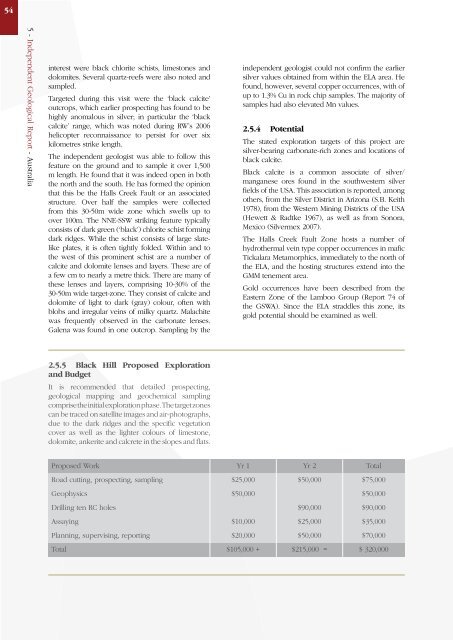
2.5.5 Black Hill Proposed Exploration<br />
and Budget<br />
It is recommended that detailed prospecting,<br />
geological mapping and geochemical sampling<br />
comprise the initial exploration phase. The target zones<br />
can be traced on satellite images and air-photographs,<br />
due to the dark ridges and the specific vegetation<br />
cover as well as the lighter colours of limestone,<br />
dolomite, ankerite and calcrete in the slopes and flats.<br />
independent geologist could not confirm the earlier<br />
silver values obtained from within the ELA area. He<br />
found, however, several copper occurrences, with of<br />
up to 1.3% Cu in rock chip samples. The majority of<br />
samples had also elevated Mn values.<br />
2.5.4 Potential<br />
The stated exploration targets of this project are<br />
silver-bearing carbonate-rich zones and locations of<br />
black calcite.<br />
Black calcite is a common associate of silver/<br />
manganese ores found in the southwestern silver<br />
fields of the USA. This association is reported, among<br />
others, from the Silver District in Arizona (S.B. Keith<br />
1978), from the Western <strong>Mining</strong> Districts of the USA<br />
(Hewett & Radtke 1967), as well as from Sonora,<br />
Mexico (Silvermex 2007).<br />
The Halls Creek Fault Zone hosts a number of<br />
hydrothermal vein type copper occurrences in mafic<br />
Tickalara Metamorphics, immediately to the north of<br />
the ELA, and the hosting structures extend into the<br />
GMM tenement area.<br />
Gold occurrences have been described from the<br />
Eastern Zone of the Lamboo Group (Report 74 of<br />
the GSWA). Since the ELA straddles this zone, its<br />
gold potential should be examined as well.<br />
Proposed Work Yr 1 Yr 2 Total<br />
Road cutting, prospecting, sampling $25,000 $50,000 $75,000<br />
Geophysics $50,000 $50,000<br />
Drilling ten RC holes $90,000 $90,000<br />
Assaying $10,000 $25,000 $35,000<br />
Planning, supervising, reporting $20,000 $50,000 $70,000<br />
Total $105,000 + $215,000 = $ 320,000