Download - BC Water & Waste Association
Download - BC Water & Waste Association
Download - BC Water & Waste Association

You also want an ePaper? Increase the reach of your titles
YUMPU automatically turns print PDFs into web optimized ePapers that Google loves.
CHalleNGes and OppOrtuNities for sustainable water stewardship in<br />
The Upper<br />
Kiskatinaw River<br />
At the time the US Army Corp of<br />
Engineers constructed the City of Dawson Creek’s<br />
water supply system during the Second World<br />
War, it would have been hard to imagine how<br />
much the landscape within the upper Kiskatinaw<br />
River <strong>Water</strong>shed (UKRW) would change in the<br />
decades to follow. The unstable silty drainage<br />
system, that gave definition to its Woodland<br />
Cree name of ‘muddy river,’ is known for its high<br />
natural spikes in turbidity after spring freshet and<br />
intense rainfall periods. Very little land-use activity<br />
in those days would have added to this impact<br />
in the watershed. Traditional resource harvesting,<br />
by both First Nations and the rural settlers who<br />
farmed and ranched in the lower reaches of the<br />
drainage system, included annual fishing for<br />
Arctic grayling and bull trout in the tributaries.<br />
Natural processes that cause frequent slope<br />
erosion and sedimentation have remained the<br />
dominant operational challenge, particularly after<br />
winter thawing and spring freshet.<br />
Once raw water is pumped from an intake<br />
on the river near Arras, it is elevated and filtered<br />
through a series of four constructed reservoirs with<br />
200 million gallons of capacity over a distance<br />
of 16 km to the treatment plant located just<br />
south of the City. Given this reliance on the upper<br />
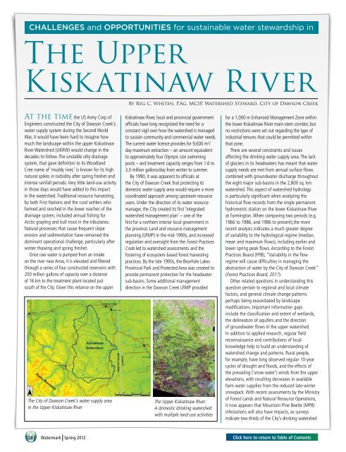
The City of Dawson Creek’s water supply area<br />
in the Upper Kiskatinaw River<br />
28<br />
<strong>Water</strong>mark Spring 2012<br />
By Reg C. Whiten, P.Ag. MCIP, <strong>Water</strong>shed Steward, City of Dawson Creek<br />
Kiskatinaw River, local and provincial government<br />
officials have long recognized the need for a<br />
constant vigil over how the watershed is managed<br />
to sustain community and commercial water needs.<br />
The current water licence provides for 9,600 m 3 /<br />
day maximum extraction – an amount equivalent<br />
to approximately four Olympic size swimming<br />
pools – and treatment capacity ranges from 1.6 to<br />
3.0 million gallons/day from winter to summer.<br />
By 1990, it was apparent to officials at<br />
the City of Dawson Creek that protecting its<br />
domestic water supply area would require a more<br />
coordinated approach among upstream resource<br />
users. Under the direction of its water resource<br />
manager, the City created its first ‘integrated<br />
watershed management plan’ – one of the<br />
first for a northern interior local government in<br />
the province. Land and resource management<br />
planning (lRMP) in the mid-1990s, and increased<br />
regulation and oversight from the Forest Practices<br />
Code led to watershed assessments and the<br />
fostering of ecosystem-based forest harvesting<br />
practices. By the late 1990s, the Bearhole Lakes<br />
Provincial Park and Protected Area was created to<br />
provide permanent protection for the headwater<br />
sub-basins. Some additional management<br />
direction in the Dawson Creek lRMP provided<br />
The Upper Kiskatinaw River:<br />
A domestic drinking watershed<br />
with multiple land-use activities<br />
for a 1,000 m Enhanced Management Zone within<br />
the lower Kiskatinaw River main-stem corridor, but<br />
no restrictions were set out regarding the type of<br />
industrial tenures that could be permitted within<br />
that zone.<br />
There are several constraints and issues<br />
affecting the drinking water supply area. The lack<br />
of glaciers in its headwaters has meant that water<br />
supply needs are met from annual surface flows<br />
combined with groundwater discharge throughout<br />
the eight major sub-basins in the 2,800 sq. km<br />
watershed. This aspect of watershed hydrology<br />
is particularly significant when analyzing the<br />
historical flow records from the single permanent<br />
hydrometric station on the lower Kiskatinaw River<br />
at Farmington. When comparing two periods (e.g.<br />
1966 to 1986, and 1986 to present),the more<br />
recent analysis indicates a much greater degree<br />
of variability to the hydrological regime (median,<br />
mean and maximum flows), including earlier and<br />
lower spring peak flows. According to the Forest<br />
Practices Board (FPB), “Variability in the flow<br />
regime will cause difficulties in managing the<br />
abstraction of water by the City of Dawson Creek”<br />
(Forest Practices Board, 2011).<br />
Other related questions in understanding this<br />
question pertain to regional and local climate<br />
factors, and general climate change patterns<br />
perhaps being exacerbated by landscape<br />
modifications. Important information gaps<br />
include the classification and extent of wetlands,<br />
the delineation of aquifers and the direction<br />
of groundwater flows in the upper watershed.<br />
In addition to applied research, regular field<br />
reconnaissance and contributions of local<br />
knowledge help to build an understanding of<br />
watershed change and patterns. Rural people,<br />
for example, have long observed regular 10-year<br />
cycles of drought and floods, and the effects of<br />
the prevailing (‘snow-eater’) winds from the upper<br />
elevations, with resulting decreases in available<br />
farm water supplies from the reduced late-winter<br />
snowpack. With recent assessments by the Ministry<br />
of Forest lands and Natural Resource Operations,<br />
it now appears that Mountain Pine Beetle (MPB)<br />
infestations will also have impacts, as surveys<br />
indicate two-thirds of the City’s drinking watershed<br />
click here to return to table of contents