July/August 2004 - Kansas Historical Society
July/August 2004 - Kansas Historical Society
July/August 2004 - Kansas Historical Society

Create successful ePaper yourself
Turn your PDF publications into a flip-book with our unique Google optimized e-Paper software.
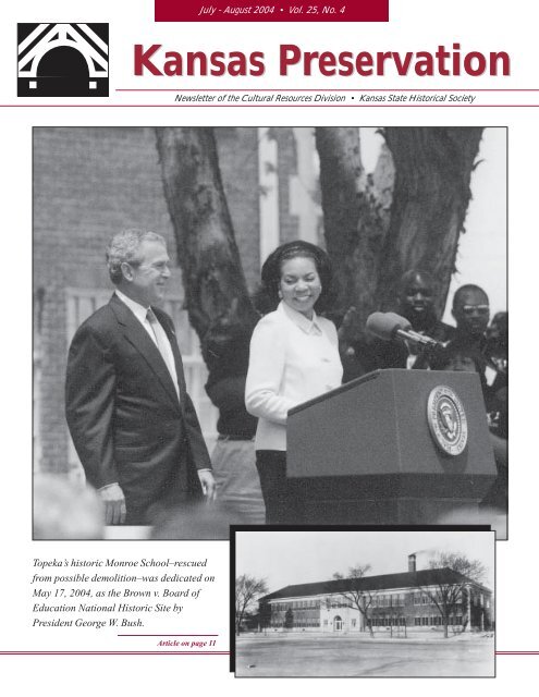
Topeka’s historic Monroe School–rescued<br />
from possible demolition–was dedicated on<br />
May 17, <strong>2004</strong>, as the Brown v. Board of<br />
Education National Historic Site by<br />
President George W. Bush.<br />
<strong>July</strong> - <strong>August</strong> <strong>2004</strong> � Vol. 25, No. 4<br />
<strong>Kansas</strong> Preservation<br />
Newsletter of the Cultural Resources Division � <strong>Kansas</strong> State <strong>Historical</strong> <strong>Society</strong><br />
Article on page 11
1<br />
Contents<br />
3<br />
Walgreens Targets Historic<br />
<strong>Kansas</strong> Properties<br />
7<br />
Prairie Style Homes<br />
11<br />
Brown v. Board of Education<br />
National Historic Site<br />
13 - 22<br />
<strong>Kansas</strong> Archeology Training<br />
Program Field School<br />
KANSAS PRESERVATION<br />
Published bimonthly by the Cultural Resources<br />
Division, <strong>Kansas</strong> State <strong>Historical</strong> <strong>Society</strong>, 6425 S.W.<br />
Sixth Avenue, Topeka, KS 66615-1099.<br />
Please send change of address information<br />
to the above address or e-mail<br />
cultural_resources@kshs.org.<br />
Third-class postage paid at Topeka, <strong>Kansas</strong><br />
Terry W. Marmet,<br />
Interim State Historic Preservation Officer<br />
Richard Pankratz, Editor<br />
Virginia Wulfkuhle, Associate Editor<br />
Tracy Campbell, Editorial & Design Services<br />
Partial funding for this publication is provided by the<br />
National Park Service, Department of the Interior.<br />
The contents and opinions do not necessarily reflect<br />
the views or policies of the Department of the<br />
Interior, nor does the mention of trade names or<br />
commercial products constitute an endorsement or<br />
recommendation by the Department of the Interior.<br />
This program receives federal funds from the<br />
National Park Service. Regulations of the U.S.<br />
Department of the Interior strictly prohibit unlawful<br />
discrimination in departmental federally assisted<br />
programs on the basis of race, color, national origin,<br />
age, or handicap. Any person who believes he or<br />
she has been discriminated against in any program,<br />
activity, or facility operated by a recipient of federal<br />
assistance should write to: Office of Equal<br />
Opportunity, National Park Service, 1849 C Street<br />
NW, Washington, DC 20240.<br />
2005 Historic Preservation<br />
Fund Grant Applications<br />
Now Available<br />
Application materials for the fiscal<br />
year 2005 round of the Historic Preservation<br />
Fund (HPF) grant program are<br />
now available from the <strong>Kansas</strong> Historic<br />
Preservation Office (KHPO).<br />
The Historic Preservation Fund is<br />
a federal grant program from the<br />
National Park Service (NPS), Department<br />
of the Interior. The NPS passes<br />
funds through state preservation<br />
offices to assist local organizations<br />
and governments in implementing<br />
activities that will contribute to<br />
planning for the preservation of our<br />
built environment and<br />
archeological resources.<br />
Eligible activities include<br />
surveys of historic structures<br />
and archeological<br />
sites, the production of<br />
nominations to the National<br />
Register of Historic Places,<br />
the development of historic<br />
preservation plans, and<br />
historic preservation-related<br />
educational programs.<br />
Activities financed by the<br />
HPF should be directed toward<br />
providing individuals and organizations<br />
with the information and means<br />
to support preservation efforts in their<br />
own communities.<br />
Historic Preservation Fund grants<br />
are awarded to organizations such as<br />
historical societies, universities,<br />
regional planning commissions,<br />
nonprofit corporations, Certified Local<br />
Governments (CLG), and city and<br />
county governments. Up to 60 percent<br />
of the project costs may be financed<br />
by the HPF. The other 40 percent must<br />
be furnished by the project sponsor<br />
and can be provided in cash or in-kind<br />
services and materials.<br />
The KHPO expects to have<br />
approximately $100,000 to award for<br />
projects in 2005. A minimum of<br />
approximately $60,000 is reserved for<br />
projects proposed by CLGs. In fiscal<br />
year 2005 applications for the following<br />
activities will be given a higher<br />
priority: surveys in downtown<br />
business districts in designated<br />
Mainstreet Partnership Cities and<br />
other <strong>Kansas</strong> communities, surveys in<br />
areas facing development pressures,<br />
and projects that have the potential<br />
for increasing knowledge and awareness<br />
of historic resources concerning<br />
minority populations in <strong>Kansas</strong>.<br />
Because the statewide preservation<br />
conference for 2006 will be hosted by<br />
the City of Lawrence, additional<br />
applications are not being solicited for<br />
conferences.<br />
Proposed HPF projects are<br />
evaluated according to several criteria.<br />
These include the need for the project<br />
Historic Preservation Fund grants<br />
are awarded to organizations such<br />
as historical societies, universities,<br />
regional planning commissions,<br />
nonprofit corporations, Certified<br />
Local Governments (CLG), and<br />
city and county governments.<br />
to address historic preservation issues<br />
in the state, the soundness of the<br />
proposed project, the administrative<br />
ability of the applicant, and the<br />
educational potential of the project.<br />
Well-developed grant proposals that<br />
address priorities established by the<br />
KHPO will have a competitive<br />
advantage in the evaluation process.<br />
Potential applicants may submit<br />
preliminary applications for staff<br />
review. The preliminary application<br />
deadline is October 1, <strong>2004</strong>.<br />
Applications for the HPF grants<br />
must be postmarked no later than<br />
November 15, <strong>2004</strong>, or delivered in<br />
person to the KHPO in its offices at<br />
6425 SW Sixth Avenue, Topeka, by<br />
4:30 p.m. on that date.<br />
For more information on this<br />
program, please contact the grants<br />
manager at (785) 272-8681 Ext. 216 or<br />
cultural_resources@kshs.org.<br />
This article was prepared by Teresa Kiss,<br />
grants manager in the Cultural<br />
Resources Division.
Use of Federal Tax Incentives in<br />
<strong>Kansas</strong> Increases<br />
(Right) The Midland Hotel in Wilson was rehabilitated<br />
and reopened as a hotel in 2003.<br />
(Below) The old Lincoln School in Newton was<br />
rehabilitated for senior housing in 2002.<br />
More than 31,000 historic buildings<br />
across the United States have been<br />
revitalized through a program started in<br />
1976 to offer federal income tax incentives<br />
to property owners who rehabilitate<br />
historic buildings for an income-producing<br />
purpose. Those rehabilitations<br />
represent a private investment in historic<br />
properties of more than $31 billion since<br />
1977. Property owners receive federal<br />
income tax credit equal to 20 percent of a<br />
qualifying project’s expenses if the<br />
rehabilitation is completed according to<br />
the Secretary of the Interior’s Standards<br />
for Rehabilitation. The program is<br />
administered by the National Park Service<br />
in coordination with the Internal Revenue<br />
Service and the State Historic Preservation<br />
Offices in each state.<br />
This tax credit has been available to<br />
Kansans since its inception, but recent<br />
years have seen its use grow. In federal<br />
fiscal year 2000 there was only one<br />
rehabilitation project completed through<br />
this program with a private investment of<br />
$37,000. <strong>Kansas</strong> was among the states<br />
with the fewest projects and ranked fortyseventh<br />
in private investments. By fiscal<br />
year 2002 completed projects in the state<br />
grew to three with a total private investment<br />
of $2.8 million. However, this still<br />
left <strong>Kansas</strong> toward the bottom of the<br />
ranking of states utilizing the program.<br />
Oklahoma had seven completed projects<br />
in 2002 with a total investment of $7.5<br />
million while Missouri ranked much<br />
higher with forty-five completed projects<br />
totaling more than $87.5 million in private<br />
investment.<br />
The added incentive of a state<br />
income tax credit signed into law in 2001<br />
has gradually attracted more investment<br />
in historic preservation and rehabilitation<br />
projects in <strong>Kansas</strong>. With the addition of a<br />
state income tax credit equal to 25 percent<br />
of qualifying project expenses, property<br />
owners could recoup up to 45 percent of<br />
their projects’ expenses in the form of tax<br />
credits. For the first time this made<br />
rehabilitation projects for many historic<br />
properties financially feasible.<br />
As developers and property owners<br />
submitted applications for these programs<br />
and began to complete projects, the<br />
statistics for <strong>Kansas</strong> rose. In fiscal year<br />
2003 seventeen projects were completed<br />
in <strong>Kansas</strong> utilizing the federal tax credit<br />
program. These projects represented a<br />
total private investment of more than $27<br />
million. The increase in projects and total<br />
investments put <strong>Kansas</strong> in the middle of<br />
the state rankings. As the number of new<br />
projects in <strong>Kansas</strong> continues to rise, the<br />
number of historic buildings being saved<br />
from demolition and neglect also increases.<br />
For more information on tax incentives<br />
for rehabilitation of historic buildings,<br />
including private residences and<br />
other non-income producing properties,<br />
please contact the Cultural Resources<br />
Division of the <strong>Kansas</strong> State <strong>Historical</strong><br />
<strong>Society</strong> at (785) 272-8681 Ext. 240 or<br />
cultural_resources@kshs.org.<br />
This article was prepared by Katrina L.<br />
Klingaman, tax credits coordinator in the<br />
Cultural Resources Division.<br />
2
3<br />
The Alf Landon House in Independence, <strong>Kansas</strong>, was the<br />
home of the <strong>Kansas</strong> governor and 1936 U.S. presidential<br />
candidate from 1915 to the late 1930s.
Walgreens<br />
Chain<br />
Targets<br />
Historic<br />
<strong>Kansas</strong><br />
Properties<br />
The Walgreen Company has plans to<br />
clear a block of buildings near<br />
downtown Independence, <strong>Kansas</strong>,<br />
to make room for a new drive-thru<br />
pharmacy. Among the historic buildings<br />
threatened by the proposed action is the<br />
Independence home of famed <strong>Kansas</strong><br />
governor and 1936 presidential candidate<br />
Alfred (Alf) Landon. Despite the obvious<br />
historical significance of the<br />
property, it has never been<br />
listed on the National Register<br />
of Historic Places. The<br />
absence of such a designation<br />
may make the home more<br />
difficult to protect.<br />
The Landon Home at 300<br />
West Maple was constructed<br />
in 1901 by Dr. J. T. Davis. Alf<br />
Landon’s father, John Landon,<br />
purchased the house in 1915<br />
for Alf and his new bride. After he<br />
returned from World War I, Alf lived in the<br />
house until he was elected governor in<br />
1932. Landon used images of the house<br />
in campaign materials for his 1936<br />
presidential bid.<br />
Walgreens Threatens<br />
“Corner of Main & Main”<br />
If the Walgreen Company proceeds<br />
with its current plans, the home of this<br />
significant politician will be lost. Unfortunately,<br />
this threat to a significant property<br />
by big-box pharmacy retailers is not<br />
unique. Since Walgreens announced<br />
plans to open 6,000 more stores nationwide<br />
in the first decade of the twenty-first<br />
This Walgreens store replaced the Fleming Mansion at the southwest corner of 10 th<br />
and Gage in Topeka.<br />
century, preservationists and community<br />
leaders have banded together to protect<br />
historic buildings from the cornerpharmacy<br />
onslaught.<br />
Residents of Buffalo, New York’s<br />
Elmwood neighborhood fought the<br />
demolition of nine homes for the construction<br />
of a 14,000 square-foot store in<br />
1995. In 2000, Walgreens razed the famed<br />
Despite the obvious historical significance of<br />
the Landon property, it has never been listed<br />
on the National Register of Historic Places.<br />
The absence of such a designation may make<br />
the home more difficult to protect.<br />
Kahiki Supper Club in Columbus, Ohio.<br />
The company targeted the First National<br />
Bank and Trust Company in East Chicago<br />
for demolition in late 2003; the 1918<br />
structure was famous for being robbed in<br />
1934 by John Dillinger.<br />
The Walgreen Company’s proposed<br />
demolition of two Victorian<br />
houses in Rockland, Massachusetts, in<br />
1999 captured the attention of the<br />
National Trust for Historic Preservation<br />
(Trust), which named the “Corner of<br />
Main and Main,” threatened by chain<br />
drugstores, to its annual eleven most<br />
endangered properties list. In a 1999<br />
interview with Katie Couric on NBC’s<br />
Today Show, Trust President Richard<br />
Moe brought the threat to the attention<br />
of the nation. He urged national<br />
drugstore chains to follow the lead of<br />
other national retailers, which retrofit<br />
existing buildings for their stores.<br />
Saving the Fleming Mansion<br />
Historic <strong>Kansas</strong> buildings have not<br />
been immune to drugstore development.<br />
The state’s first high-profile case involved<br />
plans to remove the<br />
Fleming Mansion at the corner<br />
of 10 th and Gage in Topeka to<br />
make way for a 14,500 squarefoot<br />
Walgreens.<br />
The historic home was built<br />
in 1926 by George Godfrey<br />
Moore, president of Topeka’s<br />
National Reserve Life Insurance<br />
Company. When Ned Fleming,<br />
who joined his father’s Fleming<br />
Mercantile Company in 1921,<br />
purchased the property, the home became<br />
known as the Fleming Mansion. In 1982,<br />
the large estate–with the mansion<br />
anchoring the northeast corner–was<br />
converted into the Fleming Place shopping<br />
center.<br />
Although at the time of the shopping<br />
center’s construction, the developers<br />
vowed they would not build on the corner<br />
where the historic mansion stood,<br />
difficulties leasing the building for<br />
commercial uses caused them to change<br />
their plans. They first floated the idea of<br />
rezoning the property for a new corner<br />
Walgreens in 1997. At that time, the<br />
Topeka Planning Commission denied the<br />
zoning to replace the home with a new<br />
pharmacy. After the business that<br />
4
occupied the building was closed down<br />
in 2000, developers failed to find a new<br />
tenant. In late 2002, they once again<br />
proposed a zoning change, removal of the<br />
building, and new construction. The<br />
project was reviewed by the State Historic<br />
Preservation Office (SHPO). Although<br />
the property was not itself protected<br />
under the state preservation statute, it<br />
was located within the environs of the<br />
historic Anton-Woodring House. After<br />
5<br />
(Above) The Fleming<br />
Mansion is shown at its<br />
historic location at<br />
10th and Gage in<br />
Topeka.<br />
(Right) The mansion in<br />
route to its new<br />
location northwest of<br />
Sixth and Wanamaker<br />
in Topeka, near the<br />
<strong>Kansas</strong> History Center.<br />
Photos courtesy of<br />
Topeka Capital-Journal.<br />
This article was prepared by<br />
Christy Davis, assistant director of<br />
the Cultural Resources Division.<br />
the SHPO determined that the demolition<br />
would negatively impact the environs of<br />
the listed property, the Topeka City<br />
Commission, after a six-hour debate in<br />
January 2003, voted to overturn the<br />
SHPO’s comments, deciding that there<br />
were no “feasible and prudent alternatives”<br />
to removing the property. Developers<br />
were able to save the building from<br />
demolition when a buyer offered to move<br />
it to a location northwest of Sixth and<br />
Wanamaker in Topeka; however, moving<br />
the structure took it out of its historic<br />
context and disqualified it for listing on<br />
the National Register.<br />
The Fleming Mansion was<br />
saved from demolition when<br />
a buyer offered to move it to<br />
a location northwest of Sixth<br />
and Wanamaker in Topeka;<br />
however, moving the<br />
structure took it out of its<br />
historic context and<br />
disqualified it for listing on<br />
the National Register.<br />
Landon Home on the Line<br />
Like the Fleming Mansion, the Alf<br />
Landon home in Independence has long<br />
been the subject of local debate. The<br />
home was first threatened with demolition<br />
in 1986 when the Independence Zoning<br />
Commission voted to approve a rezoning<br />
of the property from residential to commercial.<br />
However, the City Commission was<br />
not able to garner the unanimous vote<br />
needed to proceed with the rezoning in<br />
light of the neighbors’ petition to prevent it.<br />
Landon’s Independence home is not<br />
listed on the National Register of Historic<br />
Places (neither is the home Landon<br />
constructed in Topeka following his failed<br />
presidential bid), a designation that would<br />
provide an added layer of protection from<br />
the threat of chain drugstore development.<br />
Since identifying the threat of<br />
chain drugstores to historic neighborhoods,<br />
the Trust has obtained written<br />
commitments from four nationwide<br />
drugstore chains, including Walgreens,<br />
that they will not demolish properties<br />
individually listed on the National<br />
Register of Historic Places.<br />
Like the Fleming Mansion, the Alf<br />
Landon House does have some protection<br />
under the state preservation statute<br />
because it happens to be located within<br />
the environs of several listed properties.<br />
However, as in the case of the Fleming<br />
Mansion, the determination can be<br />
appealed to the local governing body. If<br />
the local governing body determines that<br />
there are no feasible and prudent alternatives<br />
to the project and no one sues in<br />
district court, the project may proceed.<br />
If the Landon Home is demolished,<br />
the home of one of the state’s most<br />
significant national figures will be lost.<br />
Furthermore, the historic context of the<br />
Cont. on page 10
Sold on eBay!<br />
Kansans Find Success in Marketing<br />
Threatened Buildings to the World<br />
What’s the latest trend in marketing vacant buildings? The<br />
popular internet auction site, eBay.<br />
eBay builds on the old-fashioned concept of expanding<br />
product markets, introducing local products to a global marketplace.<br />
Our state’s vacant buildings, many of them historic, fit<br />
well into the niche. Many creative <strong>Kansas</strong> communities struggling<br />
to find a buyer for significant buildings have successfully<br />
attracted the attention of the international marketplace eBay<br />
places at their fingertips. Businesses are attracted not only to<br />
the state’s relatively low property values, but also to its friendly<br />
citizens. The result is a “win-win” for <strong>Kansas</strong>: communities<br />
save the buildings that represent their local history and new<br />
businesses are attracted to the state.<br />
The citizens of McCracken, <strong>Kansas</strong> struck eBay gold when<br />
their vacant 43,000-square-foot 1918 middle school was sold<br />
for $50,000 to a Phoenix-based company in 2003. After unsuc-<br />
cessfully offering the building to forty charities, the LaCrosse<br />
unified school district took the advice of its district secretary<br />
and placed the McCracken building on the eBay auction block.<br />
In the thirty days the building was featured on the web, the site<br />
had 22,000 hits and the district received approximately 1,700<br />
email inquiries. When the bidding came to a close, the ad had<br />
gleaned 200 offers from 23 states and many other countries<br />
including Japan. The successful bidders plan to move their eBay<br />
business “enginepowered” to McCracken. One of the selling<br />
points was the friendly <strong>Kansas</strong> reception the business owners<br />
received.<br />
The <strong>Kansas</strong> communities of Gaylord and Morland have also<br />
sold school buildings on eBay. The City of Gaylord sold its<br />
school for $25,000 to the Seattle owners of an internet-based<br />
business. The building would have cost the city $100,000 to<br />
demolish. Now it will be added to the community’s tax rolls.<br />
Early this year, the Morland Community Foundation<br />
sold a school building (headquarters for the 2002<br />
<strong>Kansas</strong> Archeology Training Program) on eBay. Bison<br />
America, Inc. purchased the building for $125,000 to<br />
serve as the headquarters of the Bison Institute of<br />
the High Plains. This museum and educational center<br />
will eventually attract visitors to this small town<br />
(population 164).<br />
Communities are using eBay to save local business<br />
buildings as well. A 1904 bank in Hill City was<br />
posted on the site on May 19, <strong>2004</strong>. At the close of<br />
bidding on June 19, <strong>2004</strong>, the building sold for a<br />
successful bid of $73,100.<br />
In its short history as a tool for marketing historic<br />
buildings, eBay has successfully matched local<br />
communities with businesses and organizations<br />
seeking low-cost facilities in friendly <strong>Kansas</strong> communities.<br />
This not only often saves these buildings<br />
from the wrecking ball, but also puts them to use in<br />
ways that economically benefit the state.<br />
This article was prepared by Christy<br />
Davis, assistant director of the Cultural<br />
Resources Division.<br />
6
The Prairie style of regional archi<br />
tecture was popularized by Frank<br />
Lloyd Wright (1867- 1959) in the<br />
early part of the twentieth century. This<br />
low-lying, horizontal planar form was a<br />
reaction to the massive, highly decorative<br />
Victorian styling of the nineteenth<br />
century. Linked with the Arts and Crafts<br />
movement, the Prairie School was based<br />
on the belief that form follows function,<br />
i.e., the form of the building is determined<br />
by its function. The defining characteristics<br />
of the style include an integrated<br />
relationship between the building and the<br />
setting, low horizontal lines, and open<br />
flowing floor plans. The style was<br />
residential in conception and application.<br />
7<br />
The Wright Stuff<br />
Prairie Style Homes on the Prairie<br />
Clarence Shepard’s design for the Gates House, located at 4146 Cambridge in <strong>Kansas</strong> City, comes<br />
late in the Prairie School lineage.<br />
Creators of Prairie Style<br />
It was in the Chicago studio of Louis<br />
Sullivan that Wright and others, including<br />
Marion Mahony and Dwight Perkins,<br />
worked on developing the designs that<br />
became known as the Prairie School.<br />
Known as the “Eighteen,” the group<br />
practiced at Steinway Hall in Chicago<br />
from 1894 until 1902. Wright became the<br />
dominant figure and left to establish his<br />
home studio in Oak Park in 1902.<br />
Wright’s seminal designs were<br />
generated during this time and include the<br />
1893 Winslow House in River Forest and<br />
the 1901 Willits House in Highland Park,<br />
both in Illinois. By the time Wright<br />
Architectural Style in <strong>Kansas</strong><br />
designed his most famous Prairie style<br />
house, the 1909 Robie House in Hyde<br />
Park, Illinois, he had left the Steinway Hall<br />
and formed his Oak Park atelier or studio.<br />
These three designs show the style<br />
moving from a box to an extended series<br />
of horizontal planes.<br />
Although Wright is the most<br />
influential of the Prairie School architects<br />
and is most often associated with the<br />
style, the Steinway Hall group was<br />
influential in their own right. Among the<br />
talented architects were Mahony, Perkins,<br />
Walter Burley Griffin, William Gray<br />
Purcell, Percy Dwight Bentley, and<br />
William Drummond. Mahony was the<br />
only woman among them, the first woman<br />
This is the fifth in the series of architectural style articles to be published in<br />
<strong>Kansas</strong> Preservation. The articles are designed to provide general background<br />
information about architectural style and may also be used as context statements<br />
for National Register nominations.
graduate of Massachusetts Institute of<br />
Technology’s architectural program, and<br />
the most talented delineator in the group.<br />
Her contributions include an extensive<br />
group of Prairie Style residences in<br />
Mason City, Iowa. Many other lesser<br />
known architects were associated with<br />
the group over time, and by extension, the<br />
impact of the Steinway Hall studio had a<br />
significant ripple effect nationwide.<br />
The concept of the atelier or studio is<br />
one of fundamental importance in the field<br />
of architecture, with apprentices working<br />
under the master. The Prairie School grew<br />
out of such an atelier. Wright went on to<br />
establish the Taliesin West studio in 1932;<br />
it still serves as a school for architects.<br />
Many of Wright’s own designs as well as<br />
Wright-inspired designs can be purchased<br />
from Taliesin, allowing modern<br />
materials to be used for a Prairie Schoolinspired<br />
design.<br />
From Wright’s point of view, the<br />
Prairie School evolved because of his<br />
interest in affordable housing for the<br />
middle class. This was a theme he began<br />
with and ended with later in his career<br />
with Usonian houses. In between,<br />
however, the homes he designed and built<br />
were for the upper class. These are the<br />
(Left) Builder examples of the Prairie style include<br />
window banks, horizontal massing, and deep eaves.<br />
(Lower left and below) Japanese pagoda influences<br />
were incorporated into the Shepard and Belcher<br />
design for Mount Barbara in Salina. The geometric<br />
cut glass found in this Mount Barbara window is a<br />
classic example of the Wright tradition.<br />
Glossary<br />
Casement window - a window<br />
having at least one window sash<br />
which swings open along its<br />
entire length; usually on hinges<br />
fixed to the sides of the opening<br />
into which it is fitted<br />
Eaves - the lower edge of a sloping<br />
roof; that part of a roof of a<br />
building which projects beyond<br />
the wall<br />
Stretcher bond - bricks laid horizontally<br />
with their length in the<br />
direction of the face of the wall<br />
Usonian - small, affordable<br />
houses designed by Frank Lloyd<br />
Wright during the first half of the<br />
20 th century featuring flat roofs,<br />
carports and open living spaces;<br />
(Usonia was Wright’s term for<br />
the United States of North<br />
America, with an i added for<br />
pleasing sound.)<br />
8
The Henry J. Allen House (255 North Roosevelt, Wichita) is the only <strong>Kansas</strong> residence for which Frank Lloyd Wright supervised the design<br />
and construction.<br />
homes, like the Robie House in Hyde Park<br />
and the Henry J. Allen House in Wichita,<br />
that are the landmark examples of the<br />
style.<br />
But in the beginning, the style grew<br />
from the simple, regional four-square<br />
farmhouse with a hipped roof. Wright<br />
transformed this basic form into a new<br />
architectural genre by lowering the<br />
profile; emphasizing the horizontal;<br />
organizing horizontal, continuous window<br />
bands; using stucco and stained wood;<br />
and shifting the entrance to the side. Two<br />
prototypical designs were commissioned<br />
by and published in Ladies Home<br />
Journal in 1907. “A Fireproof House for<br />
$5000” became Wright’s most influential<br />
design, as it reached thousands and<br />
introduced the style to the middle class.<br />
The Prairie style was popularized by<br />
builders who picked up elements or entire<br />
9<br />
The following publications may be helpful<br />
for determining and describing style:<br />
H. Allen Brooks. The Prairie School: Frank<br />
Lloyd Wright and His Midwest Contemporaries.<br />
New York: Norton, 1972.<br />
Alan Gowans. The Comfortable House:<br />
North American Suburban Architecture<br />
1890-1930. Cambridge, MA: MIT<br />
Press, 1986.<br />
Neil Levine. The Architecture of Frank Lloyd<br />
Wright. Princeton, NJ: Princeton<br />
University Press, 1996.<br />
James C. Massey and Shirley Maxwell.<br />
House Styles in America: The Old-House<br />
Journal Guide to the Architecture of American<br />
Homes. New York: Penguin, 1996.<br />
William A. Radford. Radford’s Cement<br />
Houses and How to Build Them. Chicago:<br />
Radford Architectural Company, 1909.<br />
Marcus Whiffen and Frederick Koeper.<br />
American Architecture, 1607-1976.<br />
Cambridge, MA: MIT Press, 1981.<br />
concepts of the<br />
design. Across the<br />
country there are<br />
examples of homes<br />
with low-standing<br />
eaves, low walls,<br />
and window banks.<br />
Many of these<br />
designs were<br />
ordered from<br />
building catalogues<br />
or were the work of<br />
local builders.<br />
While the style was<br />
most popular from<br />
1905-1920, its<br />
impact is still felt<br />
today. A close look<br />
at the common<br />
ranch style home<br />
constructed from<br />
the 1950s to the present reveals antecedents<br />
to the Prairie style in its geometry,<br />
horizontal emphasis, and open simplicity<br />
of floor plan.<br />
Publications such as the aforementioned<br />
Ladies Homes Journal, Architectural<br />
Record, and House Beautiful helped<br />
to disseminate the style. William<br />
Radford’s Chicago-based architectural<br />
and engineering publication company<br />
blended the Prairie style with twentieth<br />
century concrete building technology in a<br />
1909 publication for builders.<br />
Elements of Prairie Style<br />
Organic in nature, the Prairie style<br />
used native building materials for its form.<br />
Throughout the long, low horizontal<br />
planes, the subtle influence of Japanese<br />
architecture pervades. This horizontality<br />
translated nicely into the suburban<br />
medium of residential architecture.<br />
Conceived around a large hearth, the floor<br />
plan was open and flowing, integrating<br />
gardens and terraces with the interior of<br />
the house. Low sloping roofs, overhanging<br />
eaves, and tall casement window<br />
Vernacular examples of the Prairie style were often built as<br />
Foursquares.<br />
banks were key design features that<br />
placed the house within the landscape<br />
rather than on it. With the number of<br />
parts reduced and the extension of<br />
horizontal planes, the house could be<br />
integrated naturally into the landscape.<br />
Typically Prairie style houses are<br />
two-story, sometimes three. The traditional<br />
basement is eliminated by raising<br />
the house off the ground. The major<br />
living quarters were up one flight of stairs<br />
for a better view. The visual and functional<br />
emphasis is placed on the top half<br />
of the residence.<br />
Often built of masonry, either rough<br />
stone or brick laid in stretcher bond, the<br />
designers of Prairie style homes sought a<br />
material that would blend naturally with<br />
its surroundings. Stucco and wood were<br />
also used frequently for lower end homes.<br />
High style homes featured beautifully<br />
finished interior woodwork. Heating,<br />
lighting, plumbing, and mechanical<br />
systems were designed as architectural<br />
features. Often the architect would<br />
design the furniture and carpeting, to<br />
make the building as one.
Prairie Style in <strong>Kansas</strong><br />
Although <strong>Kansas</strong> sits squarely on<br />
the prairie, the state boasts only one<br />
residential example of Frank Lloyd<br />
Wright’s work. The Henry J. Allen House<br />
was built for the prominent <strong>Kansas</strong><br />
statesman and his wife Elsie between 1917<br />
and 1919. While Wichita has many<br />
vernacular examples of the style, some<br />
dating before the construction of the<br />
Allen House, Wright’s mark stands clearly<br />
on this landmark example. Coming late in<br />
the first phase of his residential designs,<br />
the house includes a courtyard, garden<br />
teahouse, and massive brick wall. Its low<br />
horizontal sprawling yet palatial appearance<br />
clearly shows the influence of<br />
Japanese design.<br />
<strong>Kansas</strong> City-based architect Clarence<br />
Shepard worked in the Prairie style, with<br />
landmark examples in Salina and <strong>Kansas</strong><br />
City. Shepard may have worked as a<br />
draftsman for Wright during the Oak Park<br />
studio period, between 1902 and 1905. He<br />
is said to have preferred the Prairie style<br />
above all others, designing his own home<br />
in that genre. Shepard had an extensive<br />
residential practice in the <strong>Kansas</strong> City<br />
metropolitan area and was associated<br />
with the J. C. Nichols Company.<br />
Shepard collaborated with Hardborne<br />
Belcher to design a three-story, native<br />
stone villa in Salina for Mr. and Mrs.<br />
Daniel Albert “Bert” Nelson. Constructed<br />
between 1916 and 1918, Mount Barbara<br />
stands prominently overlooking the city<br />
of Salina, yet, because of its use of native<br />
stone, low hanging eaves, low horizontal<br />
lines, projecting eaves and window<br />
banks, the massive house blends<br />
naturally with its wooded surroundings.<br />
Several years later, Shepard designed<br />
a straight-forward landmark example of<br />
the Prairie style for Judge Louis Gates.<br />
Located on a small suburban lot in<br />
<strong>Kansas</strong> City, the two-story stuccoed,<br />
frame house is surmounted by a hip roof<br />
with wide overhanging eaves. Constructed<br />
in 1922-1923, the Gates House is<br />
a late example of the style.<br />
Throughout the state stand other<br />
landmark quality residences done in the<br />
Prairie style tradition. Additionally there<br />
are even more residences that stand as<br />
vernacular examples of the style. As a<br />
class of buildings, these are typically well<br />
built and stand the test of time. Many<br />
could be listed on the National Register<br />
because of their architectural significance<br />
as examples of the Prairie style.<br />
This article was written by Martha<br />
Hagedorn-Krass, architectural<br />
historian with the Cultural<br />
Resources Division.<br />
Walgreens Targets Historic Properties<br />
Landon home will be lost if the<br />
surrounding buildings are destroyed<br />
or if the home is moved. Local<br />
preservationists are working to see<br />
the building protected.<br />
Bibliography<br />
Anderson, Ric. “Commission votes<br />
against moving Fleming house.” Topeka<br />
Capital-Journal, November 18, 1997.<br />
Curtis, Wayne. “The Tiki Wars.” The<br />
Atlantic Monthly, February 2001.<br />
Foster, Margaret. “Bank Survives<br />
Dillinger and Walgreens.” Preservation<br />
Online, June 24, 2003. nationaltrust.com/<br />
archives/arc_news/063403.htm.<br />
Hall, Mike. “Developer wants new<br />
Walgreens.” Topeka Capital-Journal,<br />
December 10, 2002.<br />
Hall, Mike and Alicia Henrickson.<br />
“Fleming Mansion evokes memories.”<br />
Topeka Capital-Journal, January 9, 2003.<br />
Hartman, Carol. “Preservationists see<br />
trouble in town centers: chain drugstores.”<br />
Associated Press and Boston<br />
Globe, June 15, 1999.<br />
Heritage Trust Applications Available<br />
The <strong>Kansas</strong> Historic Preservation<br />
Office (KHPO) announces the availability<br />
of applications for the 2005 round of<br />
Heritage Trust Fund (HTF) grants in<br />
early September. The HTF is a state<br />
program that provides matching funds<br />
for the preservation of properties listed<br />
on the National Register of Historic<br />
Places or the Register of Historic <strong>Kansas</strong><br />
Places. This is a competitive grant program<br />
in which applications compete for<br />
the funds available for that year.<br />
The deadline for applications in this<br />
round of grants is March 1, 2005. Applications<br />
must be complete and postmarked<br />
by the March 1 deadline. If an<br />
application is hand delivered, it must be<br />
received no later than 4:30 p.m. at the<br />
<strong>Kansas</strong> Historic Preservation Office on<br />
that date. Final selection of projects will<br />
be made at the May 2005 meeting of the<br />
<strong>Kansas</strong> Historic Sites Board of Review.<br />
Preliminary applications, which the<br />
KHPO staff will review and provide<br />
Cont. from page 5<br />
Heslam, Jessica. “History Channel to<br />
recount fight against drugstore.” Patriot<br />
Ledger, 1999.<br />
Historic Landmarks Foundation of<br />
Indiana. “Breaking the bank.” News<br />
Story, December 2003.<br />
Hooper, Michael. “Fleming finished in<br />
city.” Topeka Capital-Journal, <strong>August</strong> 23,<br />
2003.<br />
National Trust for Historic Preservation.<br />
“Issues and Initiatives: Chain Drugstores.”<br />
Nationaltrust.org/issues/<br />
drugstores/index.html.<br />
Sternberg, Hilary. “ Ban the Box’ Move.”<br />
Buffalo Preservation Report, June 1995.<br />
preservationcoalition.org/bpr/9506bpr/<br />
banbox.html<br />
Stingl, Jim. “Let’s Everybody Drink to<br />
Historic Preservation.” Milwaukee<br />
Journal Sentinel, March 21, 2003.<br />
Today Show, June 17, 1999. Transcript<br />
on burrows.com/rocknews.html.<br />
Von Stroheim, Otto. “Kahiki vs.<br />
Walgreens.” Tikinews.com/mailarchive/<br />
msg0035.html, April 27, 2000.<br />
’<br />
comments on, must be submitted by 4:30<br />
p.m., January 18, 2005. Preliminary applications<br />
are not required but are highly<br />
encouraged.<br />
HTF grant workshops will be held in<br />
locations around the state. The first will be<br />
held in Topeka at the <strong>Kansas</strong> History Center,<br />
Potawatomi Mission, Potawatomi<br />
Room (second floor), on Thursday, September<br />
16, <strong>2004</strong>, at 2 p.m. Other dates<br />
and locations are included in the calendar<br />
on the back cover of this issue.<br />
Additional information about the HTF<br />
grant program can be found on our web<br />
site at kshs.org under “Preserve,” “Buildings,”<br />
“Find Funding.”<br />
To request an application packet,<br />
please contact the <strong>Kansas</strong> Historic Preservation<br />
Office at (785) 272-8681 Ext. 216 or<br />
cultural_resources@kshs.org or write<br />
Heritage Trust Fund, <strong>Kansas</strong> Historic Preservation<br />
Office, <strong>Kansas</strong> State <strong>Historical</strong><br />
<strong>Society</strong>, 6425 SW Sixth Avenue, Topeka,<br />
<strong>Kansas</strong>, 66615-1099.<br />
10
11<br />
Cheryl Brown Henderson of the Brown Foundation introduced President George W. Bush at the<br />
dedication of the Brown v. Board National Historic Site. Photo by Donna Rae Pearson.<br />
In the first decades following its construction in 1926,<br />
Topeka’s Monroe School was one of the city’s four<br />
all-black elementary schools. With the landmark 1954<br />
Supreme Court decision striking down the “Separate But<br />
Equal” doctrine, the school gained a place in American<br />
history. Parents of several Monroe students were<br />
plaintiffs in one of the five school desegregation cases<br />
combined into Oliver L. Brown et al. v. Board of Education<br />
of Topeka, <strong>Kansas</strong> et al.<br />
Amid the changes that followed the Brown ruling, the<br />
school building would have been lost had it not been for<br />
a group of dedicated volunteers. On May 17, <strong>2004</strong>,<br />
Monroe School once again received national attention<br />
with its dedication as the Brown v. Board of Education<br />
National Historic Site. The dedication represented not<br />
only a reflection on five decades of struggle toward<br />
equality, but also a celebration of the preservation of the<br />
historically significant Monroe School.<br />
In the school’s original design, Thomas Williamson,<br />
arguably Topeka’s best regarded twentieth-century<br />
architect, employed reinforced board-formed concrete<br />
slabs, beams, and joists to create a structure that would<br />
stand the test of time. However, the building nearly did<br />
not survive its first half-century. In the years following<br />
Brown v. Board, African-American students began<br />
enrolling in traditionally white schools; white students,<br />
however, did not enroll in the city’s traditionally black<br />
schools. The trend resulted in a precipitous decline in<br />
Monroe’s enrollment, which remained entirely African<br />
American. In 1958, just four years following the landmark<br />
case, the school’s enrollment had fallen to 148, approximately<br />
one-third its capacity. Faced with the sharp decline<br />
in enrollment, the school district closed Monroe in 1975.<br />
From the time of its closure, the school’s future<br />
became progressively more uncertain. A 1970s rezoning of<br />
the surrounding neighborhood from residential to light<br />
industrial/commercial seemed to seal the neighborhood’s<br />
fate, making it doubtful the building would ever again be<br />
used as a school. (Ironically, the school district then<br />
constructed a new science magnet school just one block to<br />
the north in 1995.)<br />
The school district used the building for storage until<br />
1980 when it sold the building to Richard Appelhans.<br />
Appelhans then sold the building in 1982 to Fairlawn<br />
Church of the Nazarene, which began remodeling the<br />
building for use as a dental clinic, clothing bank, and a<br />
halfway house. To accommodate the new use, the church<br />
made many changes to the building’s interior, from<br />
The background on pages 11 and 12 and the front cover image of Monroe School<br />
soon after its construction are provided courtesy of the National Park Service.<br />
Brown v<br />
Culmina<br />
Fifty years ago, T<br />
brought national<br />
segregation. No<br />
Brown v. Board<br />
Historic Site,<br />
interpret the de<br />
future
. Board Dedication Marks<br />
tion of Preservation Effort<br />
opeka’s Monroe School<br />
ttention to the issue of<br />
w as the home of the<br />
of Education National<br />
Monroe School will<br />
segregation story for<br />
generations.<br />
installing partitions and closing in staircases to removing<br />
classroom walls and wood wardrobes. In 1988, soon after<br />
making irreversible changes, the church sold Monroe<br />
School. The new owners, S/S Builders, Inc., made additional<br />
interior changes to use the building for storage.<br />
When S/S Builders’ owner Mark Stueve posted an<br />
auction notice on the fence surrounding the building in<br />
1990, many in the community feared the building would be<br />
demolished. A group of dedicated volunteers fought to<br />
stop the auction. Among them was Cheryl Brown<br />
Henderson, a daughter of Brown v. Board plaintiff Oliver<br />
Brown. Henderson had formed the Brown Foundation just<br />
two years earlier to carry on the effort toward educational<br />
equality. The group hoped to designate the building a<br />
National Historic Landmark that could serve to interpret<br />
the story of school integration.<br />
The Brown Foundation’s efforts bore fruit in 1991<br />
when the Trust for Public Land purchased Monroe School<br />
and the building was designated a National Historic<br />
Landmark through an amendment to the National Historic<br />
Landmark nomination for Sumner School, an all-white<br />
school that some of the children of Brown v. Board of<br />
Education plaintiffs would have attended had the schools<br />
not been segregated. In 1992, the U. S. Congress passed<br />
Public Law 102-525 establishing Monroe School as the<br />
Brown v. Board of Education National Historic Site. Soon<br />
after this designation, in December 1993, the property was<br />
transferred to the National Park Service.<br />
View of the Monroe School following its restoration. Photo courtesy of National Park<br />
Service.<br />
This article was prepared by Christy Davis, assistant director<br />
of the Cultural Resources Division.<br />
After obtaining title to Monroe School, the National<br />
Park Service (NPS) began planning for the building’s restoration<br />
and rehabilitation. In 1996, the NPS published a<br />
General Management Plan that provided guidance on the<br />
interpretation of the site. The 1998 Historic Structures<br />
Report provided a history of the building’s construction<br />
and renovations and put forth recommendations regarding<br />
restoration work. Exterior construction, including<br />
repointing, stone cleaning, steel window repair, and exterior<br />
door repair/replacement began in 2001; interior work<br />
began the next year. In 2003-<strong>2004</strong>, the exhibits and audiovisual<br />
equipment to accommodate the building’s new<br />
interpretive visitors’ center function were installed. The<br />
State Historic Preservation Office reviewed the plans in<br />
accordance with Section 106 of the National Historic<br />
Preservation Act.<br />
Although Monroe School was saved, its context was<br />
compromised as neighborhood homes were condemned<br />
and demolished. Once again, national attention would<br />
play a part in the neighborhood’s rehabilitation. The<br />
Brown Foundation worked with Congress to establish a<br />
Presidential Commission for the fiftieth anniversary of the<br />
Brown decision. This President-commissioned dedication<br />
would draw the media spotlight to the Monroe<br />
neighborhood–a prospect that spurred the City of<br />
Topeka to allocate federal funds from the Department of<br />
Cont. on back cover<br />
12
The <strong>2004</strong> <strong>Kansas</strong> Archeology<br />
Training Program (KATP) field school<br />
held at site 14MP407 in McPherson<br />
County provided an opportunity to study<br />
an archeological site via remote sensing.<br />
While three visible mounds suggested<br />
the locations of probable house structures,<br />
no other potential cultural features<br />
were readily apparent. Because one<br />
aspect of the excavations sought to<br />
investigate areas outside houses in hopes<br />
of identifying outdoor activity areas, it<br />
was felt that a geophysical survey would<br />
help direct the placement of units outside<br />
structures. Archaeo-Physics, LLC from<br />
Minneapolis, Minnesota, was contacted<br />
to conduct a shallow subsurface geophysical<br />
survey of the site.<br />
The geophysical investigation in<br />
April <strong>2004</strong> included both electrical<br />
resistance and magnetic field gradient<br />
surveys. A total of 8,100 square meters<br />
were investigated in two separate areas of<br />
the site. In the pasture area, 6,300 square<br />
meters were surveyed by both methods.<br />
Due to rain during the latter portion of the<br />
survey period, an area of the site located<br />
in an adjacent wheat field was subjected<br />
only to the magnetic survey. Moisture on<br />
the wheat would have adversely affected<br />
the collection of resistance data. A total<br />
of 1,800 square meters was surveyed in<br />
the wheat field.<br />
The Tools of Geophysical<br />
Investigation<br />
The two forms of geophysical survey<br />
used are described below in order to<br />
familiarize the reader with the instruments<br />
and the basic principles behind each type<br />
of survey. In an electrical resistance<br />
survey, an electrical current is sent<br />
through the soil with the intent of<br />
measuring the relative ease or difficulty<br />
with which the current moves through the<br />
soil. Variations in these readings can be<br />
viewed as variance in the resistance of<br />
the soil matrix at any point within the<br />
survey grid.<br />
The electrical resistance survey<br />
equipment is a portable unit, consisting of<br />
two probes placed 50 centimeters apart,<br />
that is connected by cables to two other<br />
probes established outside the survey<br />
grid to serve as the control against which<br />
the mobile unit measures relative resis-<br />
13<br />
Laying the Groundwork<br />
The Geophysical Survey of 14MP407<br />
This aerial view shows the approximate locations of the east and west survey areas at<br />
14MP407.<br />
tance. In a particular survey grid (here<br />
established as 30 x 30-meter blocks), the<br />
individual carrying the mobile unit moves<br />
back and forth across the grid at 1-meter<br />
intervals with two readings taken every<br />
meter. A reading is taken when the<br />
prongs on the mobile unit are pushed into<br />
the soil, completing the electrical circuit<br />
created by the mobile probe and the stationary<br />
probes. The collected data is then<br />
processed to allow for the best visibility<br />
of cultural features. One result of this<br />
processing is that natural variation is minimized<br />
through filtering, allowing subtle<br />
cultural features to appear more readily.<br />
A magnetic field gradient survey<br />
operates with the assumption that the<br />
earth’s magnetic field at the surface is<br />
uniform and has zero gradient. A geologic<br />
anomaly or cultural disturbance adds to<br />
this field, and, therefore, the gradient is<br />
no longer zero. Readings taken by the<br />
gradiometer during survey measure this<br />
deviation from the homogenous natural<br />
magnetic field and record it as positive (in<br />
same direction as the earth’s magnetic<br />
field) and negative (opposite to the<br />
earth’s magnetic field) responses. Iron<br />
and steel objects, of course, are readily<br />
identified with this survey and can<br />
adversely affect the interpretation of the<br />
data. The surveyor must take care not to<br />
have any metal on himself while carrying<br />
the gradiometer during the survey, as the<br />
instrument will read that as well.<br />
Archeologically important features<br />
can have varying degrees of remnant and<br />
field magnetization. Examples of remnant<br />
magnetization are hearths, burned<br />
structures and support posts, and<br />
pottery. Field magnetization can include<br />
anything that may have disturbed the<br />
natural magnetic field present across the<br />
earth’s surface, such as excavated cultural<br />
features like posts, pits, and basins.<br />
The magnetic field gradient survey<br />
equipment consists of a handheld unit<br />
with two sensors set 50 centimeters apart.<br />
Collected data represents the recorded<br />
variation between the two sensors.<br />
Within the grid block, the surveyor walks<br />
with a very consistent pace back and<br />
forth at 50-centimeter intervals. The<br />
instrument takes eight readings per meter<br />
along each transect. Processing of the<br />
magnetic data includes filtering to remove<br />
background noise, allowing for cultural<br />
patterning to be more apparent. Process-
ing also compensates for minor variations<br />
in instrument orientation and lateral<br />
movement across the block and assures<br />
that a consistent number of data points<br />
are collected in every square meter of<br />
survey across the grid.<br />
Interpreting the Results<br />
Results of the geophysical survey at<br />
14MP407 were promising even from the<br />
most preliminary interpretation available<br />
while the crew was still in the field.<br />
Several anomalies were readily apparent<br />
and seemed to represent excellent<br />
candidates for cultural features outside of<br />
the visible house mounds.<br />
In addition to yielding important<br />
information about a number of anomalies<br />
that appeared to be of cultural origin<br />
outside structures, the survey shed<br />
additional light on the three visible<br />
mounds in the pasture. It was apparent<br />
that Mound 1 and Mound 2 had similar<br />
magnetic signatures, suggesting that<br />
structures in both locations likely had<br />
burned. On the other hand, Mound 3 had<br />
a very different magnetic signature, one<br />
that was not nearly as chaotic and strong<br />
as that seen in the first two instances.<br />
Based on this information, it is hypothesized<br />
that the structure associated with<br />
Mound 3 did not burn and that anomalies<br />
clustered in that area may well represent<br />
internal features, such as pits, basins,<br />
posts, etc. A number of anomalies<br />
outside the vicinity of the mounds were<br />
identified as having a high potential for<br />
being cultural features.<br />
In early May, with the help of Gary<br />
Parks of the Natural Resource Conservation<br />
Service (NRCS) and a truck-mounted<br />
Giddings soil probe, several anomalies in<br />
the pasture were cored to determine the<br />
nature of the various anomalies. In the<br />
adjacent wheat field, several anomalies<br />
were cored with handheld soil probes.<br />
The term used for this stage of<br />
investigation is ground truthing. Ground<br />
truthing is an important part of the<br />
geophysical investigation because it is<br />
when the accuracy of the interpretation of<br />
the geophysical data is realized. The<br />
hope is that the coring will consistently<br />
confirm the presence of cultural features,<br />
particularly in spots that are judged to be<br />
high potential anomalies.<br />
High potential features consistently<br />
had a strong correlation between the<br />
magnetic and resistance data; in other<br />
words, the anomaly was readily visible in<br />
both sets of data. Ground truthing of<br />
these anomalies confirmed the presence<br />
of cultural features in every instance.<br />
Typically, the core revealed a darker,<br />
organically enriched disturbed soil that<br />
The geophysical survey produced detailed maps of 14MP407. Shown here are the results<br />
of the combined resistance and magnetic data from the pasture area. This method of<br />
display is a useful means of identifying correlations between data sets.<br />
contained occasional flecks of charcoal<br />
and burned earth. In one case, a chert<br />
flake and a burned corn kernel were<br />
present in a soil core extracted from a pit<br />
feature. Other anomalies were cored that<br />
had either a magnetic signature or an<br />
electrical resistance signature with little<br />
correlation between the two. Cultural<br />
features were identified in approximately<br />
half of these and were generally recog-<br />
nized to be subtler in appearance, that is,<br />
with lighter disturbed fill and fewer<br />
instances of charcoal and burned earth.<br />
The ground truthing confirmed a number<br />
of known cultural features that could be<br />
investigated during the June field school.<br />
During the KATP investigations, a<br />
limited number of these features were<br />
investigated. In addition to working on<br />
features identified during the earlier<br />
14
ground truthing of larger anomalies by<br />
soil probing, the opportunity presented<br />
itself to investigate an area that encompassed<br />
a series of smaller anomalies. This<br />
area was thought to possibly represent a<br />
circular or ovoid post pattern, perhaps<br />
representing an arbor or shade structure<br />
where some daily activities of the site’s<br />
inhabitants may have occurred. Such<br />
small features could not effectively be<br />
investigated by soil coring but could best<br />
be identified by opening a series of excavation<br />
units. A group of <strong>Kansas</strong> Anthropological<br />
Association volunteers enrolled<br />
in the Basic Archeological Excavation<br />
class were given the task of ground<br />
truthing this area. One unit placed in this<br />
vicinity yielded evidence of a large post<br />
that may correspond with one of the small<br />
anomalies identified in the geophysical<br />
survey. A small basin was also identified<br />
15<br />
in the same area and may represent a<br />
larger anomaly that probably masks in<br />
part the post in the same location.<br />
Initial interpretation of the excavation<br />
of the Mound 2 structure suggests that at<br />
least some of the identified cultural<br />
features may have corresponding<br />
anomalies identified in the geophysical<br />
survey. The overall chaotic signature of<br />
the Mound 2 area precluded interpretation<br />
of these individual features originally.<br />
During the excavation, a number of<br />
soil samples were collected from small<br />
features (posts and basins), the profile of<br />
the Mound 2 fill, and an area isolated from<br />
cultural features that shows a relatively<br />
undisturbed soil profile. Additional<br />
research involving these soil samples in<br />
the near future will help identify some of<br />
the variables that allowed for the identification<br />
of the anomalies at this site.<br />
(Left) A Natural Resources Conservation Service (NRCS)<br />
Giddings rig was used to ground truth a number of the<br />
anomalies detected during the geophysical survey.<br />
(Below) NRCS soil scientist Gary Parks, Tod Bevitt, and Martin<br />
Stein examine a soil core extracted by the Giddings rig.<br />
Acknowledgments: The work by<br />
Archaeo-Physics, LLC was made<br />
possible by a generous<br />
contribution from the Midwest<br />
Archeological Center of the<br />
National Park Service. Thanks go<br />
to the NRCS for its cooperation in<br />
providing a soil scientist and<br />
equipment for ground truthing.<br />
This article was prepared by<br />
C. Tod Bevitt and Dave Maki.<br />
Bevitt is an independent<br />
consultant under contract to the<br />
<strong>Kansas</strong> State <strong>Historical</strong> <strong>Society</strong> for<br />
the field investigation, data<br />
analysis, and reporting of the<br />
<strong>2004</strong> KATP field school. Maki is a<br />
partner in Archaeo-Physics, LLC,<br />
of Minneapolis, Minnesota.
Housework and Yard ard Work ork<br />
This aerial view, looking west across 14MP407, shows the setting of the site in relation to the surrounding countryside.<br />
The excavation area is shown in the upper left and the Smoky Hill River is on the right.<br />
The 29th <strong>Kansas</strong> Archeology<br />
Training raining Program Investigates<br />
a Smoky Hill Phase Habitation Site<br />
Introduction and Background<br />
The <strong>2004</strong> <strong>Kansas</strong> Archeology Training Program<br />
(KATP) recently concluded a 16-day field school during<br />
which portions of a Smoky Hill earthlodge and several<br />
areas outside of this and other houses were investigated.<br />
The KATP has twice before visited the<br />
Lindsborg vicinity, in 1992 and 1993, with work at the<br />
Sharps Creek site (14MP408), a late sixteenth- and early<br />
seventeenth-century protohistoric Wichita village. A<br />
total of 133 volunteers contributed more than 5,800<br />
hours in the field and lab to help make the investigations<br />
at 14MP407 a success. While additional work is<br />
required to finish the artifact processing and cataloguing<br />
later this year, the contributions of the volunteer<br />
crew provided a solid foundation upon which the<br />
interpretation can begin.<br />
Fieldwork focused on a habitation site attributed to<br />
the Smoky Hill phase of the Central Plains tradition.<br />
Smoky Hill phase radiocarbon dates suggest a general<br />
range of A.D. 1050-1350, with some sites perhaps dating<br />
earlier and some later. Sites of the phase are found<br />
along the major drainages of the region: the Smoky Hill,<br />
Solomon, Saline, Blue, and <strong>Kansas</strong> Rivers and their<br />
tributaries. Key sites include the Salina burial pit<br />
(14SA1) and nearby habitation site (14SA414), the<br />
Minneapolis site (14OT5), and the Griffing site (14RY21)<br />
near Manhattan. Extensive investigations have been<br />
conducted at several other sites over the past 60 to 70<br />
years, which collectively has helped to establish a<br />
limited understanding of this culture.<br />
Smoky Hill houses are commonly identified as<br />
square to rectangular structures of varying sizes, often<br />
with extended entryways. Circular structures also occur<br />
occasionally, though it is not known what this variation<br />
signifies. Interior features such as a central hearth, large<br />
support posts and one or more storage pits are found in<br />
almost every instance with these structures. Many sites<br />
contain multiple structures, with some having as many<br />
as two dozen or more individual houses that are<br />
16
This view, looking south across the excavation units concentrated on Mound 2, shows the volunteer crew in action.<br />
identified by low mounds or artifact<br />
clusters. More commonly, sites are<br />
smaller and have indications of one to<br />
three structures. Little evidence is<br />
available to suggest that houses at any<br />
one site were all occupied simultaneously.<br />
While instances of contemporaneous<br />
occupation are certainly possible, in the<br />
majority of cases multiple houses likely<br />
represent repeated use of a particular<br />
location over time.<br />
Smoky Hill material culture can be<br />
divided into several functional categories.<br />
Ceramic assemblages, generally consisting<br />
of utilitarian pottery, include small to<br />
large globular jars and bowls, typically<br />
cordmarked and occasionally decorated,<br />
tempered with sand or grog (crushed<br />
sherds). Bone objects consist of digging<br />
implements, such as scapula hoes and<br />
tibia digging stick tips manufactured from<br />
bison bone; deer metapodial beamers for<br />
hideworking; awls manufactured from<br />
various bones and bone fragments;<br />
mussel shell hoes; and bone and shell<br />
beads, just to name a few classes of<br />
artifacts. Small triangular arrow points<br />
(often side and/or basal notched), end<br />
scrapers, diamond beveled knives, flake<br />
drills, and numerous informal flake tools<br />
17<br />
comprise the lithic tool kit. Ground stone<br />
objects, such as manos and metates,<br />
abraders, and axes and celts, could be<br />
expected in a typical assemblage.<br />
Together these objects give archeologists<br />
a glimpse into the types of activities<br />
carried out in the daily lives of a site’s<br />
original inhabitants.<br />
KAA member Harold Reed recorded<br />
14MP407 in 1971. Richard Stauffer,<br />
another KAA member who also had a<br />
collection from the site, recently added to<br />
the original record, contributing valuable<br />
information regarding potential features<br />
he had observed in an adjacent wheat<br />
field. Long known to local collectors, the<br />
site has been subjected to occasional<br />
digging over the years, resulting in a very<br />
noticeable crater in Mound 1 and a trench<br />
excavation in Mound 2. The Mound 2<br />
trench yielded a collection of materials<br />
that the owner was gracious enough to<br />
show and even lend a portion for<br />
analysis. The data will provide important<br />
additional information on the house that<br />
became the focus of the <strong>2004</strong> KATP.<br />
The area of the site investigated this<br />
year lies in a pasture. Though not in<br />
native grass, it is apparent that the land<br />
was not subject to long-term cultivation<br />
or deep plowing, as the cultural deposits<br />
are quite shallow and still relatively intact.<br />
Three low mounds are readily visible<br />
along the crown of the ridge upon which<br />
the site is situated. These mounds<br />
represent the locations of collapsed<br />
earthlodges.<br />
An adjacent wheat field contains<br />
another portion of the site, and a third<br />
ridge to the west has yet another cultural<br />
component, though in that instance the<br />
materials represent a later protohistoric<br />
Wichita occupation. These areas are<br />
recognized by artifact scatters in the<br />
cultivated fields. At least two collectors<br />
reported seeing dark stains in the wheat<br />
field in the vicinity of the artifact scatter<br />
at one time in the past, suggesting that<br />
pits or other cultural features might be<br />
present. Daub (burned house plaster<br />
bearing grass and/or pole impressions)<br />
was also collected from the area, suggesting<br />
the presence of a structure as well.<br />
A geophysical survey was conducted<br />
on portions of the pasture and<br />
adjacent wheat field to help identify<br />
potential cultural features in the vicinity<br />
of the house mounds and artifact scatter,<br />
respectively (see accompanying article in<br />
this issue). This work was highly
In 1934 the Nebraska State <strong>Historical</strong><br />
<strong>Society</strong> excavated a similar Plains<br />
earthlodge at the Minneapolis site in<br />
Ottawa County. An artist recreated the<br />
type of house represented by the posthole<br />
pattern.<br />
valuable in placing units outside of the<br />
Mound 2 structure, which was the focus<br />
of the KATP excavations, and also<br />
provides an excellent reference for any<br />
future investigations that might take place<br />
at the site.<br />
Research Objectives<br />
Several research questions guided<br />
the site study. One key aspect of the<br />
investigation was the recovery of plant<br />
remains to address questions about the<br />
site inhabitants diet and their reliance on<br />
horticulture and wild plants. Much of the<br />
past work on the Smoky Hill phase<br />
occurred prior to the time that soil<br />
flotation was a commonly used procedure.<br />
With this in mind, flotation samples<br />
were collected systematically from all<br />
units excavated more than 20 centimeters<br />
below the ground surface, both from<br />
inside the house fill and floor zones, as<br />
well as from outside the house. At least<br />
one-half of the fill of cultural features,<br />
such as post molds, pits, and basins, was<br />
subjected to flotation. Occasionally<br />
additional samples were taken from<br />
features and portions of the house floor.<br />
Taken together, the information gained<br />
from the analysis of these samples will<br />
inform our understanding of subsistence<br />
practices at 14MP407 and perhaps allow<br />
inferences about practices elsewhere in<br />
the Smoky Hill phase.<br />
Another question related to the excavated<br />
artifact assemblage was how certain<br />
aspects–ceramics and lithic raw material<br />
utilization, for example–compare with<br />
those of other areas, such as sites in the<br />
Salina or Minneapolis localities. Would<br />
the recovered artifacts indicate that<br />
14MP407 was distinct to a significant<br />
degree from expressions of Smoky Hill<br />
culture seen in those and other localities<br />
or could it confidently be grouped with<br />
site clusters from previously investigated<br />
areas?<br />
Finally, with regard to the site itself,<br />
what could we learn about the internal<br />
organization of the site? In order to<br />
answer this question, enough area would<br />
have to be opened to investigate not only<br />
a potential structure but adjacent areas as<br />
well. Areas outside of structures have<br />
been excluded from previous investigations<br />
at Smoky Hill phase sites; hence, a<br />
potentially large part of the daily activities<br />
of the site inhabitants had yet to be<br />
studied.<br />
18
Excavated post molds show a main structural post with a smaller supporting post.<br />
Excavation units are darkened on this topographic map of the pasture portion of the site.<br />
19<br />
The Fieldwork and<br />
Preliminary Results<br />
A total of seventy-one 1 x 1-meter<br />
units were opened across the site. Fiftyeight<br />
of these were in and around Mound<br />
2, exposing a large portion of a structure<br />
(House 2). Perimeter posts, interior posts,<br />
and features (primarily basins) were<br />
identified as the structure floor was<br />
encountered. While most of the west half<br />
of the structure was exposed, only<br />
portions of the east side were investigated<br />
thoroughly. Areas of the house<br />
that remain unopened include most of the<br />
southeast quadrant of the structure and<br />
much of the north and northeast wall<br />
areas. Additionally, no evidence of an<br />
extended entryway was found, although<br />
with much of the east edge of the house<br />
unexcavated, that is not surprising. Six to<br />
eight excavation units were clustered<br />
outside of the south-central portion of the<br />
house. A single shallow basin was<br />
identified in addition to a sparse scatter of<br />
lithic debris and ceramics. While only a<br />
small sample, this work provides tantalizing<br />
evidence of activities being carried on<br />
outside the house.<br />
It is apparent that the structure only<br />
partially burned. The northwest portion<br />
burned quite heavily, as indicated by<br />
several large interior posts charred<br />
completely to their bases and some large<br />
concentrations of daub and burned roof<br />
debris scattered across the north and<br />
west units. Other structural posts<br />
showed no evidence of burning.<br />
Four large interior posts were<br />
identified, roughly equidistant from the<br />
central hearth. These are thought to<br />
represent the primary central roof<br />
supports. The two large posts on the<br />
north side each had an associated smaller<br />
post on their north side. The northwest<br />
central support showed an interesting<br />
sequence of posts: one large post mold<br />
showed no signs of burning, while three<br />
others (two small and one large) immediately<br />
adjacent to it were heavily burned.<br />
Apparently the large post was removed at<br />
some point, perhaps because it was<br />
beginning to fail, and was replaced by<br />
another large post that burned along with<br />
other nearby posts when the structure<br />
was abandoned.<br />
Within the limits of the house, seven<br />
small features were identified as shallow<br />
basins. For the most part, these features<br />
were nearly devoid of artifacts. One exception<br />
was Feature 77 in the southwest<br />
portion of the house. Here a digging stick<br />
tip, several end scrapers, fragments of<br />
one or more scapula tools, and other debris<br />
were found within or near this large
shallow basin. Two basins located nearest<br />
the hearth were circular in plan view and<br />
had conical cross sections. It is not<br />
known what, if any, special purpose these<br />
unique features may have had. Interestingly,<br />
no deeper storage pits were encountered<br />
in the house. In many other<br />
excavated Smoky Hill houses, interior<br />
features include and are often dominated<br />
by cylindrical pits. Deeper storage pits<br />
are present at 14MP407, as several were<br />
identified in areas outside houses during<br />
coring of some of the geophysical anomalies<br />
in both the pasture and wheat field.<br />
This knowledge makes the lack of similar<br />
features in the house an interesting contrast,<br />
although it is possible that<br />
unexcavated portions of the house might<br />
reveal deeper storage facilities.<br />
Artifact distributions on the house<br />
floor present some interesting information.<br />
A relatively dense band of cultural<br />
material, including large portions of as<br />
many as four ceramic vessels, was<br />
exposed inside the west wall of the<br />
structure, continuing into the northwest<br />
corner and around to at least a portion of<br />
the area adjacent to the north wall.<br />
Numerous modified and retouched flakes<br />
were scattered across the area, as well as<br />
a few other stone tools and preforms. A<br />
cluster of charred corn and cob fragments<br />
was located along the short segment of<br />
the north wall near the northwest corner.<br />
The dense strip of debris was a consistent<br />
width wherever it was encountered,<br />
extending approximately 1 meter inside<br />
the perimeter posts. In contrast, very<br />
little material was collected from the<br />
house floor in the vicinity of the large<br />
central support posts near the hearth,<br />
suggesting that this area was kept clean,<br />
possibly as it saw heavier use by the<br />
inhabitants.<br />
The ceramic assemblage consists<br />
primarily of cordmarked, sand- and grogtempered<br />
pottery. At least two forms of<br />
vessels are present in the collection: a<br />
neckless jar or bowl with a narrow<br />
opening (commonly called a coconut jar)<br />
and the more common globular jar.<br />
Decoration is rare but was noted in at<br />
least two instances. As mentioned earlier,<br />
several large complexes of sherds were<br />
recovered and likely represent three or<br />
four reconstructible vessels or vessel<br />
sections. Work on refitting these clusters<br />
of ceramics will be just one of the focuses<br />
of the analysis that will begin this fall.<br />
Lithic artifacts include limited<br />
quantities of flake debris, particularly<br />
larger flakes. Most of the debitage is<br />
small, representing the later stages of<br />
lithic reduction to create tools, as well as<br />
the resharpening of tools. Chert from the<br />
Features are identified on this map of the House 2 excavation block.<br />
Flint Hills is by far the most common raw<br />
material in the chipped stone assemblage.<br />
Smoky Hill jasper from northwest <strong>Kansas</strong><br />
is also present in limited quantities. One<br />
unexpected find is an end scraper made of<br />
Flattop chalcedony, for which northeast<br />
Colorado is the closest source.<br />
Faunal remains are limited and<br />
typically are in poor condition. Species<br />
recognized during the excavation include<br />
bison, deer, small mammals and rodents,<br />
bird, and shellfish. Most of the identifiable<br />
bison remains came from elements<br />
useful for bone tools, such as the scapula<br />
and tibia.<br />
Floral remains recognized during<br />
fieldwork include both beans and corn.<br />
Both cultigens were identified in numerous<br />
instances. The systematic flotation<br />
samples should provide more detail about<br />
this aspect of the site remains.<br />
Approximately 10 meters southwest<br />
of the Mound 2 excavation, a 2 x 2-meter<br />
area was opened to investigate an oblong<br />
anomaly identified by the geophysical<br />
survey. It was hoped that material could<br />
be recovered to at least date this feature<br />
in proximity to House 2. The feature<br />
turned out to be a shallow oval basin that<br />
unfortunately contained almost no<br />
cultural material and was somewhat<br />
difficult to define.<br />
During the first week of the field<br />
school, Tim Weston and his Basic<br />
Archeological Excavation class investigated<br />
another area of the site, located<br />
approximately 15-20 meters northeast of<br />
Mound 1. Their assignment was to<br />
investigate seven or eight small anomalies<br />
that created an oval pattern approximately<br />
5 meters long and 4 meters wide. A total<br />
of six 1 x 1-meter units were opened in this<br />
vicinity with hopes of identifying one or<br />
more of the anomalies and determining<br />
20
whether they were of cultural or natural<br />
origin. Excavation revealed a small<br />
shallow basin and an associated post<br />
along what would be the northwest arc of<br />
the oval cluster of anomalies. In reviewing<br />
the geophysical data, it was determined<br />
that this area corresponded to a<br />
slightly larger anomaly in the group.<br />
Apparently the basin is visible in the<br />
data, and its larger signature masks in part<br />
the post mold that may very well be<br />
representative of the smaller anomalies<br />
creating the oval. Based on this, the oval<br />
is thought to represent a cultural feature,<br />
perhaps a structure of some sort, such as<br />
an arbor where some as yet undetermined<br />
activities were conducted outside of the<br />
nearby dwellings. Additional work in this<br />
area would certainly help determine the<br />
validity of this hypothesis.<br />
As work on those units was completed,<br />
three additional units were opened<br />
a short distance to the southwest, closer<br />
to Mound 1, to investigate another geophysical<br />
anomaly. This particular<br />
anomaly appeared as a large irregular<br />
feature that continued outside of the grid<br />
established for the geophysical survey.<br />
Excavators uncovered the margins of an<br />
irregular basin that carried across parts of<br />
the three 1-meter units. Very little material<br />
was collected from the feature. Its irregular<br />
form, large size, and proximity to<br />
Mound 1 make it a strong candidate for a<br />
borrow area associated with the Mound 1<br />
structure. Material for the earthen house<br />
construction would be acquired from<br />
areas immediately adjacent to the house.<br />
Typically, the shallow borrow depressions<br />
would be filled in with the waste of daily<br />
life; however, it appears that this borrow<br />
pit was not used as a trash receptacle.<br />
21<br />
Conclusions<br />
Revisiting the previously stated<br />
research objectives in light of this<br />
preliminary review of the fieldwork<br />
provides some tentative conclusions.<br />
While the bulk of the flotation<br />
remains to be analyzed, the recovery of<br />
numerous specimens of two cultivated<br />
crops (beans and corn), as well as several<br />
examples of digging implements, suggest<br />
a strong reliance on horticulture at the<br />
site. Additional study will provide more<br />
data and help complete the picture of the<br />
inhabitants’ reliance on cultigens, as well<br />
as gathered wild plants. In all, 176<br />
separate sample numbers were assigned<br />
to soil flotation samples. Approximately<br />
(Left) A bison tibia digging stick tip<br />
recovered from one of the shallow basins<br />
in House 2 suggests a reliance on<br />
horticulture at the site.<br />
(Below) The artifact scatter on the house<br />
floor inside the west wall included pottery<br />
sherds, flake tools, and a ground stone<br />
mano (left of slate).<br />
one-fourth of these samples consisted of<br />
multiple bags from a single provenience,<br />
such as basin features, large posts, and<br />
general house floor samples.<br />
At least two radiocarbon dates will<br />
be obtained from charred plant remains (a<br />
bean and a corncob) collected from the<br />
house floor. A third date will be run on a<br />
sizeable sample of wood charcoal from<br />
one of the interior posts, pending<br />
identification of the tree species represented<br />
by the sample.<br />
A large quantity of pottery was<br />
recovered and will be useful in determining<br />
the number and types of vessels<br />
present in the house. Several reconstructible<br />
vessels or vessel segments will<br />
provide good information on vessel form
This view to the southwest across the main excavation area shows the records tent on the left and sifting screens and backdirt piles on the<br />
right.<br />
and size. A varied and sizeable collection<br />
of stone tools also was found. From this<br />
assemblage and the flake debris, a picture<br />
of lithic raw material use and tool manufacture<br />
and maintenance activities will<br />
come to light. In both instances, comparisons<br />
can then be made with data from<br />
excavations in the Minneapolis and Salina<br />
vicinities.<br />
The excavation was only partly<br />
successful in exploring the topic of<br />
internal site organization. House 2 was<br />
identified and investigated, but only a<br />
portion of it was thoroughly explored. A<br />
small area outside of this particular<br />
structure was opened, allowing the<br />
definition of a shallow basin and light<br />
scatter of cultural material along the<br />
exterior of the south house wall. Other<br />
units successfully found additional<br />
external features. The possible identification<br />
of a post structure, unlike the typical<br />
Smoky Hill phase house, with an associated<br />
basin provides a glimpse into the<br />
potential for research of ancillary activity<br />
areas outside the habitations at 14MP407.<br />
Due to time limitations, investigation of<br />
known features in the wheat field was not<br />
possible. From this standpoint, additional<br />
excavations at the site would go far in<br />
helping to explore this aspect of the<br />
research goals.<br />
In spite of this shortcoming, the <strong>2004</strong><br />
KATP was a success in many ways, and it<br />
is assured that the results of the investigations<br />
at 14MP407 will help us gain a<br />
better understanding of the past inhabitants<br />
of this site and of the central <strong>Kansas</strong><br />
region during the Middle Ceramic period.<br />
Kirby Ross of Kirwin and Roger Ward of El Dorado draw the layers of earth that<br />
have been excavated, recording the profile through the middle of House 2.<br />
Acknowledgments: The cooperation and enthusiasm of the landowners,<br />
Denise and Jim Schwantes and Larry and Edie Dahlsten, are greatly<br />
appreciated.<br />
The author, C. Tod Bevitt, is an independent archeological consultant under<br />
contract to the <strong>Kansas</strong> State <strong>Historical</strong> <strong>Society</strong> for the field investigation,<br />
data analysis, and reporting of the <strong>2004</strong> KATP field school.<br />
22
Brown v. Board<br />
Dedication<br />
Return Service Requested<br />
Cont. from page 12<br />
Housing and Urban Development to make<br />
neighborhood improvements including<br />
the construction of compatible infill<br />
houses, repair of existing houses, and<br />
repair of related infrastructure.<br />
The Brown v. Board of Education<br />
National Historic Site was dedicated on<br />
May 17, <strong>2004</strong>, with remarks from Topeka<br />
Mayor James A. McClinton, U. S.<br />
Representative Elijah E. Cummings,<br />
<strong>Kansas</strong> congressional delegates, U. S.<br />
Secretary of Education Rod Paige, U. S.<br />
Assistant Secretary of the Interior Craig<br />
Manson, U. S. Secretary of the Interior<br />
Gale Norton, U. S. Supreme Court Justice<br />
Stephen Bryer, Governor Kathleen<br />
Sebelius, civil rights pioneer Reverend<br />
Fred Shuttlesworth, and President of the<br />
United States George W. Bush.<br />
With approximately five thousand<br />
people in attendance, the dedication<br />
commemorated the progress made toward<br />
educational equality; addressed the<br />
necessity of recommitting to the civic<br />
responsibility of providing equal opportunity<br />
for all citizens; and celebrated the<br />
rescue of Monroe School, a site of<br />
national historical importance.<br />
The <strong>Kansas</strong> History Center<br />
and Museum will be closed<br />
Labor Day, September 6,<br />
<strong>2004</strong>. Please check the online<br />
calendar at kshs.org for other<br />
dates and events.<br />
KANSAS STATE HISTORICAL SOCIETY<br />
Cultural Resources Division<br />
6425 S.W. Sixth Avenue<br />
Topeka, KS 66615-1099<br />
Happenings in <strong>Kansas</strong><br />
Willing to Die for Freedom:<br />
A Look Back at <strong>Kansas</strong> Territory<br />
April 3, <strong>2004</strong> - October 3, <strong>2004</strong><br />
<strong>Kansas</strong> Museum of History<br />
<strong>Kansas</strong> History Center<br />
6425 S.W. Sixth Avenue<br />
Topeka, <strong>Kansas</strong><br />
This exhibit both observes the territory’s<br />
150th anniversary and explores <strong>Kansas</strong>’<br />
free-state heritage.<br />
Sights Once Seen<br />
June 1, <strong>2004</strong> - <strong>August</strong> 30, <strong>2004</strong><br />
Research Gallery<br />
<strong>Kansas</strong> History Center and Museum<br />
The earliest form of photography is<br />
featured in this traveling exhibit<br />
recreating explorer John C. Fremont’s<br />
1853-54 expedition through the West.<br />
Over 100 daguerreotypes were taken in<br />
modern times by photographer Robert<br />
Shlaer, who retraced Fremont’s route<br />
through present-day <strong>Kansas</strong> and beyond.<br />
Heritage Trust Fund Workshop<br />
September 16, <strong>2004</strong><br />
2:00 p.m.<br />
Koch Education Center, Second Floor<br />
<strong>Kansas</strong> History Center<br />
KAA Fall Fling<br />
September 18-19, <strong>2004</strong><br />
9:00 a.m. - 4:00 p.m.<br />
Archeology Lab<br />
<strong>Kansas</strong> History Center<br />
Heritage Trust Fund Workshop<br />
October 14, <strong>2004</strong><br />
10:00 a.m.<br />
Memorial Building, Third Floor,<br />
Alliance Room<br />
101 South Lincoln<br />
Chanute, <strong>Kansas</strong><br />
KSHS, Inc. Annual Meeting<br />
November 5, <strong>2004</strong><br />
<strong>Kansas</strong> History Center<br />
Includes presentations of the Nyle H.<br />
Miller Local <strong>Historical</strong> Organization<br />
Award, Edgar Langsdorf Award,<br />
Edward H. Tihen <strong>Historical</strong><br />
Publication Awards, John Ripley Local<br />
Organization Award, speakers,<br />
election of board members and<br />
officers, and recognition of retiring<br />
and emeritus board members and<br />
executive committee members.<br />
Lewis and Clark Living History<br />
Program<br />
November 6, <strong>2004</strong><br />
<strong>Kansas</strong> History Center<br />
Captain Lewis’ Company from the<br />
Frontier Army Living History<br />
Association will present a program on<br />
Lewis and Clark. Steve Allie will give<br />
a presentation on the food eaten by<br />
the men on the Corps of Discovery<br />
expedition. The program is free and<br />
open to the public.<br />
Heritage Trust Fund Workshop<br />
November 18, <strong>2004</strong><br />
10:00 a.m.<br />
Location To Be Announced<br />
Salina, <strong>Kansas</strong><br />
Heritage Trust Fund Workshop<br />
December 9, <strong>2004</strong><br />
10:00 a.m.<br />
Carnegie Center for the Arts<br />
701 Second<br />
Dodge City, <strong>Kansas</strong><br />
Heritage Trust Fund Workshop<br />
January 13, 2005<br />
2:00 p.m.<br />
<strong>Kansas</strong> History Center<br />
NONPROFIT<br />
ORG.<br />
U.S. POSTAGE<br />
P A I D<br />
Topeka, Kans.<br />
Permit No. 299