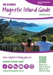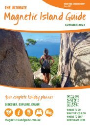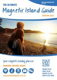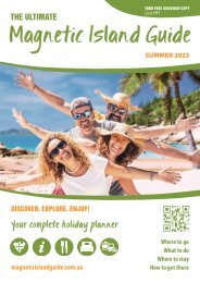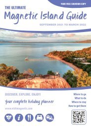
Magnetic Island Guide Winter 2022
The Magnetic Island Guide is your complete holiday planner for Magnetic Island. Find everything you need about our tropical island adventure in North Queensland.
The Magnetic Island Guide is your complete holiday planner for Magnetic Island. Find everything you need about our tropical island adventure in North Queensland.

You also want an ePaper? Increase the reach of your titles
YUMPU automatically turns print PDFs into web optimized ePapers that Google loves.
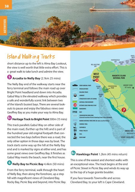
38<br />
ACTIVITIES<br />
<strong>Island</strong> Walking Tracks<br />
short distance up to the left is Alma Bay Lookout,<br />
the view is well worth that little extra effort. This is<br />
a great walk to take lunch and admire the view.<br />
5 Arcadia to Nelly Bay (2.1km 25 mins)<br />
The Nelly Bay end of the walkway starts near the<br />
ferry terminal and follows the main road up over<br />
Bright Point headland and down into Arcadia.<br />
Gabul Way is the elevated walkway which provides<br />
a safe and wonderfully scenic link between two<br />
of the <strong>Island</strong>’s busiest bays. There are several lookouts<br />
to pause and enjoy the fabulous views over<br />
Geoffrey Bay as you make your way to Alma Bay.<br />
5b Heritage Track to Bright Point 500m (15 mins)<br />
This track parallels Gabul Way on other side of<br />
the main road, (further up the hill) and is part of<br />
the hundred year old original footpath that connected<br />
the two bays before there was a road, the<br />
only other option in those days was by boat. The<br />
track starts some way up the hill at the Nelly Bay<br />
end and is marked by signs at either end, and has<br />
some great views over Geoffrey Bay. It finishes as<br />
Gabul Way meets the beach, near the first house.<br />
6 Nelly Bay to Picnic Bay 4.4km (50 mins)<br />
From the ferry terminal, walk through the heart<br />
of Nelly Bay, then along the foreshore, up a step<br />
hill with magnificent views of Cleveland Bay,<br />
Rocky Bay, Picnic Bay and beyond, into Picnic Bay.<br />
12k 12K<br />
12K DISTANCE (KM) FROM NELLY BAY<br />
FERRY<br />
ARRIVAL MANGROVES<br />
POINT<br />
REEF<br />
4k<br />
FERRY ARRIVAL POINT<br />
UNSEALED ROAD<br />
WALKING TRACK<br />
LOOKOUT<br />
WEST<br />
POINT<br />
STINGER NETS/SURF LIFE SAVING<br />
NATIONAL PARK BOUNDRY<br />
ROLLINGSTONE<br />
BAY<br />
CONSERVATION PARK ZONE<br />
(Extends from West Point & Hawking Point to the mainland)<br />
UNSEALED ROAD<br />
WALKING MARINE NATIONAL TRACKPARK ZONE (No take zone/No fishing)<br />
LOOKOUT<br />
SNORKEL TRAIL<br />
NATIONAL PARK BOUNDRY<br />
Km SHIPWRECK FROM NELLY BAY<br />
MANGROVES<br />
PUBLIC TOILETS<br />
REEF<br />
FUEL<br />
Conse rvation Park Zone<br />
Marine BOAT RAMP National Park Zone<br />
(No take zone)<br />
YOUNG<br />
BAY<br />
Conservation Park Zone extends to the mainland<br />
BOLGER<br />
BAY<br />
Townsville<br />
8kms<br />
MAUD<br />
BAY<br />
Huntingfield<br />
HUNTINGFIELD<br />
Norris<br />
Joyce NORRIS<br />
Bay BAY Wilson JOYCE<br />
WILSON<br />
BAY Bay<br />
Bay BAY<br />
Bay BAY<br />
MAGNETIC ISLAND<br />
NATIONAL PARK PARK<br />
CONSERVATION<br />
PARK<br />
6b Hawkings Point 1.2km (45 mins return)<br />
MOUNT Mt. Cook COOK<br />
497 metres<br />
497<br />
metres<br />
7<br />
COCKLE Cockle BAY Bay<br />
BACON BAY<br />
NOBBY HEADLAND<br />
This is one of the easiest and shortest walks with<br />
an exceptional view. The track begins at the end<br />
of Picnic Street in Picnic Bay and winds its way up<br />
to the top of a huge granite boulder.<br />
If you face towards Townsville and across<br />
Cleveland Bay, to your left is Cape Cleveland.