Caribbean Compass Yachting Magazine - April 2022
Welcome to Caribbean Compass, the most widely-read boating publication in the Caribbean! THE MOST NEWS YOU CAN USE - feature articles on cruising destinations, regattas, environment, events...
Welcome to Caribbean Compass, the most widely-read boating publication in the Caribbean! THE MOST NEWS YOU CAN USE - feature articles on cruising destinations, regattas, environment, events...

You also want an ePaper? Increase the reach of your titles
YUMPU automatically turns print PDFs into web optimized ePapers that Google loves.
— Continued from previous page<br />
This convinced me that this was the best way to see all the islands in the Eastern<br />
<strong>Caribbean</strong> chain (see the December 2021 and January <strong>2022</strong> issues of <strong>Compass</strong> in<br />
the Back Issues Archive at www.caribbeancompass.com). Later, Ross Norgove with<br />
White Squall II, and Jim Squier with Te Hongi followed my lead, picked up charters<br />
in Grenada, then headed north through the islands.<br />
The St. Thomas charter fleet was different from Nicholson’s Antigua fleet, as the<br />
majority of boats were 50 feet or under. With very few exceptions they were owner<br />
operated until the late 1970s, when wealthy owners in the States would send down<br />
bigger boats with hired skippers. These boats were very much resented by the owneroperated<br />
boats. The owner-operated boats had to be self-supporting, but if the<br />
skippered boats lost money chartering the owner just deducted<br />
the loss from his income tax.<br />
Some of the boats, though good sailors, were a bit long in the<br />
tooth. Some were schooners built in Maine or Nova Scotia in the<br />
1930s, during the Depression, and iron fastened. Gitana, a<br />
46-foot Nova Scotia schooner, was skippered by Hardy Wright<br />
— an unfortunate name as, although he was an excellent sailor,<br />
he was often referred to as “hardly right” or “hardly ever right.”<br />
One day while washing dishes he inadvertently dumped some of<br />
the cutlery over the side with the wash water. When he dove to<br />
pick it up he decided to check Gitana’s bottom to see whether it<br />
needed scrubbing before the Memorial Day weekend races from<br />
St. Thomas to St. Croix and return. He discovered to his horror<br />
that the iron ballast keel was about two inches below the<br />
wooden structural keel. Obviously the keel bolts were broken.<br />
He took three dock lines, looped them under the boat, tied the<br />
ends together and, using a Spanish windlass, tightened them up<br />
bar tight. He then sailed carefully to Beef Island. When Gitana<br />
was hauled she settled down on her keel so nicely that you never<br />
would’ve known that old keel bolts were broken.<br />
Augie and Lynn Hollen chartered their 45-foot Maine-built<br />
Casey schooner. Early one season the engine died. They did not<br />
tell the charter brokers and continued to accept charters.<br />
Charter parties would arrive, be greeted, shown around the boat<br />
and gear stowed. When the time came to leave the dock and the<br />
engine wouldn’t start, Augie would dive into the engine room<br />
and spend about half an hour. He then would emerge and say,<br />
”I can’t figure out what’s wrong, but we can get underway under<br />
sail. Once we are anchored this evening I will attack the engine<br />
and get it going.”<br />
They would sail off the dock and have a nice day sailing. Once<br />
anchored, awning rigged and charter party happily having<br />
sundowners in the cockpit, Augie would “work away” on the<br />
engine while Lynn cooked dinner and entertained the guests.<br />
Augie would “give up” by dinnertime, apologize for the nonworking<br />
engine, and say, “Oh, well. The boat sails so well we really don’t<br />
need the engine.” Lynn was a very beautiful gal with long red<br />
hair, a good sailor and a good cook. Augie, too, was an excellent<br />
sailor and a raconteur. They never had an unhappy charter, and<br />
never told the charter brokers that the engine didn’t work.<br />
Lynn went on to become a very successful charter broker.<br />
Augie settled in Coral Bay, St. John, built a 40-foot cowhorn schooner with a lug<br />
foresail that overlapped the mainsail. This sail had to be trimmed like a genoa on<br />
each tack. He persuaded several more sailors to build cowhorn schooners at<br />
Coral Bay, too.<br />
A last Sea Saga story<br />
Rudy Thompson, when he first arrived in St. Thomas and before his day charter<br />
days, took over skippering Sea Saga for Basil Symonette. Just before Carnival<br />
started one year Rudy booked a rather crazy charter. A couple had purchased a<br />
small guesthouse in Dominica, and wanted transportation for themselves, their<br />
grand piano and a big German Shepherd. As previously mentioned, St. Thomas<br />
charter boats seldom went east of Virgin Gorda, and Sea Saga, a gaff-rigged<br />
schooner, was not very good going to windward. But the only way to get the grand<br />
piano and the German Shepherd to Dominica was to charter a boat. Rudy was the<br />
only skipper willing to take on the charter, so he was able to negotiate a high charter<br />
fee, payable in cash before departure.<br />
They took the legs off the piano, covered it with canvas and strapped it down on<br />
the cabin top. Rudy collected the cash, gave money to his crew and told him to stock<br />
the boat for the trip, and went off to enjoy Carnival.<br />
Enjoy he did, never going to bed and arriving on Sea Saga at about 0700. They got<br />
underway, and once out of St. Thomas Harbor, Rudy brought Sea Saga hard on the<br />
wind and turned the helm over to the crew and charter party, who were moderately<br />
good sailors. He told them to just sail as close to the wind as possible and still keep<br />
the boat moving, and went below to sleep.<br />
It had been a hell of a Carnival and Rudy slept for about 18 hours. He was woken<br />
up by the German Shepherd licking his face. He was pleased to discover that a<br />
norther had come in about the time they left St. Thomas. He saw St. Kitts to<br />
starboard, just a little forward of the beam and about ten miles to leeward. He eased<br />
sheets and headed directly for Dominica. They arrived in Dominica four days after<br />
leaving St. Thomas. He had booked the charter on the basis that it would take him<br />
ten days to island-hop to Dominica, and was a very happy skipper.<br />
Meanwhile, Basil Symonette, who (according to a biography at www.wikitree.com/<br />
wiki/Symonette-24) had been popular among a fun-loving gay crowd in Miami after<br />
WWII, met a handsome man from Chicago while standing in line at the St. Thomas<br />
airport. The couple fell deeply in love and became life partners. Together they<br />
eventually built a beach bar and five-cottage resort on Virgin Gorda that expanded<br />
into the now-famous Bitter End Yacht Club.<br />
Visit Don Street’s website at www.street-iolaire.com<br />
for more stories and other information.<br />
Eastern <strong>Caribbean</strong> Charts from the Fifties to Now<br />
It was practically impossible to buy paper charts in the Eastern <strong>Caribbean</strong> in the<br />
1950s, and of course electronic charts were unheard of. There were just the bare<br />
beginnings of yacht chandleries in St. Thomas and Antigua, and neither kept charts<br />
in stock.<br />
Chart 905 was available in St. Thomas, but to obtain other charts you had to send<br />
away to New York Nautical for US charts, or Kelvin Hughes or the British Admiralty<br />
for British Admiralty charts, and ask the price of the charts and also the cost of<br />
having them airmailed to you. A bank draft had then to be purchased and sent before<br />
the charts would be shipped. Airmail was not particularly fast, so from the time the<br />
first letter was sent to when the charts were actually in your hands was a month to<br />
six weeks, sometimes longer, or sometimes never when they got lost in the mail.<br />
The US Virgin Islands were very well charted by the US Coast and Geodetic Survey<br />
in the 1920s and ’30s after the territory was purchased from Denmark. The British<br />
Virgins were covered by a British chart based on surveys done in the 1850s, but<br />
never updated or corrected. The US DMA equivalent of the BVI chart was an exact<br />
copy of the British chart.<br />
Using US charts to cover the island chain from St. Thomas to Grenada required 39<br />
charts. All the charts from the BVI to Grenada were copies of the British Admiralty<br />
charts. The British Admiralty had corrected the charts of the major harbors but<br />
other than that they were completely uncorrected.<br />
In 1975 I was on the British survey ship Fox, which was re-surveying parts of the<br />
Eastern <strong>Caribbean</strong>. The navigating officer was not particularly pleased when I went<br />
through his charts and pointed out errors that I had found that had not been<br />
Quandy, the designer Bill Aitken’s best<br />
design, was among the early St. Thomas<br />
charter yachts. Most boats in the<br />
pre-1970s fleet were 50 feet or under.<br />
corrected. He was rather embarrassed when I pointed out that the chart of St.<br />
Thomas Harbor marked “corrected to 1973” showed Ballast Island just east of<br />
Frenchtown. I pointed out that Ballast Island had been dredged out by the US Navy<br />
in about 1920, right after we purchased the Virgin Islands from the Danes!<br />
In 1979 I signed a memorandum of agreement with the late Tom Wilson, head of<br />
the chartmakers Imray, to do yachting charts of the Eastern <strong>Caribbean</strong>. The charts<br />
were to correct all the errors I had found in the British Admiralty and US charts<br />
covering the area from St. Thomas to Grenada. The area from St. Thomas to Grenada<br />
is now covered by 20 up-to-date, accurate Imray Iolaire charts. They are so highly<br />
regarded that Navionics, C Map and many other electronic chart companies pay<br />
Imray a royalty to use the information from the Imray Iolaire charts.<br />
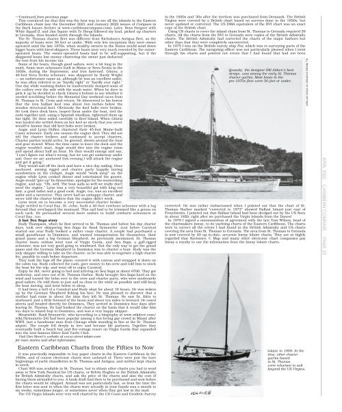
Iolaire in 1959. At the<br />
time, other charter<br />
yachts based<br />
in St. Thomas<br />
were reluctant to sail<br />
beyond the US Virgins.<br />
ALL IMAGES COURTESY OF STEVE CRYTSER<br />
APRIL <strong>2022</strong> CARIBBEAN COMPASS PAGE 23