Curaçao & Sint Maarten - UNDP Trinidad and Tobago
Curaçao & Sint Maarten - UNDP Trinidad and Tobago
Curaçao & Sint Maarten - UNDP Trinidad and Tobago
You also want an ePaper? Increase the reach of your titles
YUMPU automatically turns print PDFs into web optimized ePapers that Google loves.
Country Profile of <strong>Curaçao</strong> <strong>and</strong> <strong>Sint</strong> <strong>Maarten</strong><br />
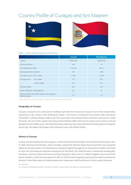
Table 1.1: Basic data of <strong>Curaçao</strong> <strong>and</strong> <strong>Sint</strong> <strong>Maarten</strong><br />
Curacao <strong>Sint</strong> <strong>Maarten</strong><br />
Capital Willemstad Philipsburg<br />
Surface area (km 2 ) 444 34<br />
Total inhabitants (2009) 141.766 40.917<br />
Population density (per km 2 ) 319 1.203<br />
Per capita income (ANG.) (2004) 31.105 31.659<br />
Life expectance men (2008) 72.2 N/A<br />
women (2008) 79.6 N/A<br />
Life birth (2008) 66.3 51.3<br />
Deaths (2008) per 100 inhabitants 8.5 3.7<br />
infant mortality rate (2008) (under 1 year of age per<br />
1000 live births)<br />
Source: Statistical Yearbook of the N.A. 2009 of the Central Bureau of Statistics<br />
Geography of <strong>Curaçao</strong><br />
6.5 7.6<br />
<strong>Curaçao</strong> is located in the southwestern Caribbean just miles from Venezuela. <strong>Curaçao</strong> is one of the isl<strong>and</strong>s which<br />
formed part of the country of the Netherl<strong>and</strong>s Antilles10 . The western countryside of the isl<strong>and</strong> is hilly with Mount<br />
Christoffel at 1230 feet being its tallest peak. The eastern part of the isl<strong>and</strong> is flatter <strong>and</strong> lower <strong>and</strong> is home to Table<br />
Mountain. Just west of the capital is the famous Three Brothers Hills which are the remains of an ancient coral reef<br />
dating back three million years. The isl<strong>and</strong> also boasts numerous bays <strong>and</strong> small inlets formed by glaciers during the<br />
last Ice Age. The largest, Schottegat on the southeast coast, is the isl<strong>and</strong>’s harbor.<br />
History of <strong>Curaçao</strong><br />
<strong>Curaçao</strong> was first inhabited by the Caiquetos, a tribe of peaceful Arawak Indians who had fled from Venezuela. Then<br />
in 1499 a lieutenant of Columbus, Alonso de Ojeda, claimed the isl<strong>and</strong> for Spain. But because there was no gold the<br />
isl<strong>and</strong> was declared useless. The isl<strong>and</strong> however remained Spanish throughout the 16th century but fell to the Dutch<br />
in 1634, later becoming an important trading post for the Dutch. The isl<strong>and</strong> became a commercial meeting place<br />
for pirates, American rebels <strong>and</strong> Dutch merchants during the 18th century. In 1800 the English took control of the<br />
isl<strong>and</strong>, withdrew in 1803 <strong>and</strong> reoccupied it in 1807. In 1816 the Dutch regained control <strong>and</strong> the isl<strong>and</strong> was declared a<br />
free port. In the 20th century the isl<strong>and</strong> assumed new importance with the discovery of oil in nearby Venezuela.<br />
10 The former Netherl<strong>and</strong>s Antilles consisted of: Bonaire, <strong>Curaçao</strong>, Saba, <strong>Sint</strong> <strong>Maarten</strong> <strong>and</strong> <strong>Sint</strong> Eustatius<br />
First National Report | <strong>Curaçao</strong> <strong>and</strong> <strong>Sint</strong> <strong>Maarten</strong> Millennium Development Goals | 2011 Report<br />
37


