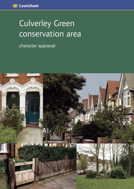
Culverley Green conservation area - London Borough of Lewisham
Culverley Green conservation area - London Borough of Lewisham
Culverley Green conservation area - London Borough of Lewisham

You also want an ePaper? Increase the reach of your titles
YUMPU automatically turns print PDFs into web optimized ePapers that Google loves.
<strong>Culverley</strong> <strong>Green</strong><br />
<strong>conservation</strong> <strong>area</strong><br />
character appraisal
<strong>Culverley</strong> <strong>Green</strong><br />
<strong>conservation</strong> <strong>area</strong><br />
Designated in 1990, <strong>Culverley</strong> <strong>Green</strong><br />
<strong>conservation</strong> <strong>area</strong> is mainly an Edwardian<br />
residential suburb built at the turn <strong>of</strong><br />
the last century. Wide tree-lined streets<br />
enhance its grid-layout. Shops, and<br />
notably the former cinema dating<br />
1913, line Bromley Road. This major<br />
thoroughfare, which was once the main<br />
coaching-route between <strong>London</strong> and<br />
Kent, cuts through the <strong>conservation</strong> <strong>area</strong>.<br />
Housing is mainly early twentieth century<br />
with some late Victorian villas remaining<br />
in Canadian Avenue. Building detail,<br />
which gives the <strong>area</strong> its special interest,<br />
includes carved and moulded capitals and<br />
window surrounds, terracotta window<br />
dressings, sash windows, solid timber<br />
doors and stained glass.<br />
1 <strong>Culverley</strong> <strong>conservation</strong> <strong>area</strong> character appraisal<br />
This character appraisal provides an assessment and<br />
definition <strong>of</strong> <strong>Culverley</strong> <strong>Green</strong>’s special historic and<br />
architectural interest as recommended by Planning<br />
Policy Guidance Note 15: Planning and the Historic<br />
Environment and English Heritage best practice<br />
advice. Appraisals are not comprehensive studies<br />
and the omission <strong>of</strong> a particular building, feature or<br />
space should not be taken to imply that it does not<br />
contribute to the character <strong>of</strong> the <strong>area</strong>. This appraisal<br />
will be a material consideration when determining<br />
planning applications and planning appeals relating<br />
to <strong>Culverley</strong> <strong>Green</strong> <strong>conservation</strong> <strong>area</strong>. Information<br />
on planning controls and appropriate alterations are<br />
given in the <strong>Culverley</strong> <strong>Green</strong> supplementary<br />
planning document available from the Planning<br />
information desk.<br />
This document was drafted following requests from<br />
the <strong>Culverley</strong> <strong>Green</strong> Residents Association in 2001.<br />
The Council’s management proposals were made<br />
available for public consultation in summer 2001.<br />
These proposals, including the making <strong>of</strong> an Article<br />
4(1) direction, were supported by 69% <strong>of</strong><br />
respondents. This character appraisal was adopted<br />
by <strong>Lewisham</strong>’s Mayor and Cabinet on 25<br />
October 2001.
Contents<br />
1 History <strong>of</strong> the <strong>area</strong> 4<br />
location and population 5<br />
origins and development <strong>of</strong> the <strong>area</strong> 5<br />
2 Form and character <strong>of</strong> the <strong>area</strong> 10<br />
Architectural and historic character 11<br />
The character <strong>of</strong> spaces within the <strong>area</strong> 13<br />
The importance <strong>of</strong> trees, gardens and parks 14<br />
Townscape analysis 15<br />
Character <strong>area</strong>s 16<br />
1. Canadian Avenue and Bromley Road including sports ground 16<br />
2. <strong>Culverley</strong>, Penerley, Bargery and Inchmery Roads 18<br />
3. Arran and Newquay Roads 19<br />
3 Negative factors 20<br />
4 Sources and contacts 24<br />
2
Ca n adian Ave<br />
Br m l e y Road<br />
o<br />
Figure 1: The <strong>Culverley</strong> <strong>Green</strong> <strong>conservation</strong> <strong>area</strong><br />
3 <strong>Culverley</strong> <strong>conservation</strong> <strong>area</strong> character appraisal<br />
<strong>Culverley</strong> Road<br />
Penerley Road<br />
Bargery Road<br />
Inchmery Road<br />
Arran Road<br />
Newquay Road
1 History <strong>of</strong> the <strong>area</strong><br />
Location and population<br />
Origins and development <strong>of</strong> the <strong>area</strong><br />
<strong>Culverley</strong> photo in 1909
1 History <strong>of</strong> the <strong>area</strong><br />
5 <strong>Culverley</strong> <strong>conservation</strong> <strong>area</strong> character appraisal<br />
Location and<br />
population<br />
The <strong>Culverley</strong> <strong>Green</strong> <strong>conservation</strong><br />
<strong>area</strong> lies to the south-west <strong>of</strong> the<br />
commercial centre <strong>of</strong> Catford in<br />
suburban south-east <strong>London</strong>.<br />
The boundaries <strong>of</strong> the <strong>area</strong> are<br />
shown in figure 1.<br />
The <strong>area</strong> is surrounded for the<br />
most part by other housing; to<br />
the west is a light industrial <strong>area</strong><br />
and railway lines, and to the<br />
north an <strong>area</strong> <strong>of</strong> shops and<br />
<strong>of</strong>fices at the heart <strong>of</strong> the town.<br />
The landscape is for the most<br />
part flat and quite heavily built<br />
up with few open spaces.<br />
An estimated 3,500 people live<br />
in the <strong>conservation</strong> <strong>area</strong>.<br />
The origins and<br />
development <strong>of</strong><br />
the <strong>area</strong><br />
There is some archeological<br />
evidence <strong>of</strong> early settlement in<br />
the <strong>area</strong> adjoining the River<br />
Ravensbourne at Catford – the<br />
terrace gravels fringing the Thames<br />
are commonly associated with the<br />
remains <strong>of</strong> successive prehistoric<br />
communities. These early<br />
inhabitants lived by a combination<br />
<strong>of</strong> agriculture and river fishing.<br />
An <strong>area</strong> including the <strong>Culverley</strong><br />
<strong>Green</strong> <strong>conservation</strong> <strong>area</strong> has been<br />
designated an Area <strong>of</strong> archeological<br />
Priority in the <strong>Borough</strong>’s Unitary<br />
Development Plan.<br />
The name Catford relates to<br />
an ancient ford to the River<br />
Ravensbourne. In the 13th<br />
century there was a manor <strong>of</strong><br />
that name, part <strong>of</strong> a larger estate<br />
centred on <strong>Lewisham</strong>. However,<br />
the <strong>area</strong> did not develop beyond<br />
a scattered agricultural settlement<br />
until the 19th century – the John<br />
Roque map <strong>of</strong> 1746 (fig 2)<br />
shows a rural landscape with no<br />
buildings at all in the vicinity <strong>of</strong><br />
the modern <strong>conservation</strong> <strong>area</strong>.<br />
By 1843 (fig 3) Sangley Farm<br />
and Sangley House were to be<br />
found to the east <strong>of</strong> Bromley<br />
Road. Sangley Farm survived<br />
until recently as the Priory House<br />
School at 61 Bromley Road.<br />
The importance <strong>of</strong> Bromley Road<br />
as the main coach road from<br />
<strong>London</strong> to Kent stimulated<br />
development <strong>of</strong> elegant villas<br />
along its length (fig 4). However,<br />
the vital factor in the growth <strong>of</strong><br />
Catford as the residential <strong>area</strong><br />
with which we are now familiar<br />
was undoubtedly the developments<br />
in public transport that occurred<br />
towards the end <strong>of</strong> the 19th<br />
century. Although the <strong>Lewisham</strong><br />
to Beckenham railway line had<br />
opened in 1857 with a station at<br />
Catford Bridge, it was the opening
in 1892 <strong>of</strong> the Catford Loop<br />
Line, with stations at Catford<br />
and Bellingham, which was more<br />
influential. Also important was<br />
the establishment during the<br />
1890s <strong>of</strong> a network <strong>of</strong> horse<br />
trams, which gave commuters<br />
access to <strong>Green</strong>wich and thus<br />
trains to <strong>London</strong>.<br />
These improvements in<br />
accessibility attracted a new<br />
working - and, increasingly,<br />
lower-middle-class population<br />
to Catford. Many <strong>of</strong> these<br />
new residents were housed in<br />
developments that spread over<br />
the grounds <strong>of</strong> the large houses<br />
that had formerly characterised<br />
the <strong>area</strong>. As the commuters<br />
moved in, the rich moved out.<br />
The large houses that fell vacant<br />
proved hard to let and the land<br />
was usually bought by developers.<br />
During the later 1890s a series<br />
<strong>of</strong> substantial villas, detached and<br />
semi-detached, began to spread<br />
along Canadian Avenue (then<br />
Berlin Road, laid out by 1894)<br />
and Bromley Road. These villas<br />
were built for local landowners<br />
the Forsters by, among others,<br />
the eminent Scottish builder<br />
James Watt (see fig 5 next page).<br />
Figure 2: Extract from the John<br />
Roque map <strong>of</strong> 1746. The modern-day<br />
<strong>conservation</strong> <strong>area</strong> was still entirely<br />
rural, without any buildings. The only<br />
features still obvious in today’s<br />
landscape are Bromley Road, running<br />
north-south, and a field track running<br />
<strong>of</strong>f this, which may have eventually<br />
become Sangley Road.<br />
6
Figure 3: Extract from the <strong>Lewisham</strong><br />
Parish Tithe Map 1843. Sangley Farm<br />
(bottom, later Priory House School,<br />
demolished) and Sangley House<br />
(demolished) are shown beside<br />
Bromley Road in what is still<br />
a rural landscape.<br />
7 <strong>Culverley</strong> <strong>conservation</strong> <strong>area</strong> character appraisal<br />
Watt was also among those Further green space was provided<br />
employed by the Forsters in the within the <strong>area</strong> by the sports<br />
development <strong>of</strong> their Sangley ground (which predates the<br />
Farm Estate on the eastern side suburb at <strong>Culverley</strong> <strong>Green</strong>), and<br />
<strong>of</strong> Bromley Road. It was this by the Catford Cricket and Lawn<br />
development which sealed Tennis Club, the pavilion and part<br />
the suburban character <strong>of</strong> the <strong>of</strong> the grounds <strong>of</strong> which survive.<br />
<strong>Culverley</strong> <strong>Green</strong> <strong>area</strong>. The planned<br />
nature <strong>of</strong> the growth <strong>of</strong> the These <strong>area</strong>s are testimony to the<br />
suburb is manifested today in strong interest <strong>of</strong> the Edwardian<br />
the regularity <strong>of</strong> the grid-like middle classes in healthy<br />
road network and in the similarity outdoor activity.<br />
<strong>of</strong> form, layout and style <strong>of</strong> the<br />
villas, discussed further below. To the north-west, the former<br />
cinema (1913, also built by James<br />
The estate, which stretched for Watt), and adjoining shops are<br />
some distance to the south <strong>of</strong> included in the <strong>conservation</strong> <strong>area</strong>.<br />
Sangley Road, was built up These high, and in the case <strong>of</strong> the<br />
piecemeal between 1902 and cinema, grand, buildings mark the<br />
the 1920s, and became a typical edge <strong>of</strong> the commercial centre <strong>of</strong><br />
middle-class Edwardian suburb. Catford, and the movement from<br />
Its character still closely reflects the suburban to the urban.<br />
the domestic aspirations <strong>of</strong> those<br />
it was designed to attract. Rows The 1936 OS map (fig 7)<br />
<strong>of</strong> semi-detached villas are set shows the <strong>area</strong> to have been<br />
back from wide, tree-lined streets substantially built up by this date.<br />
behind modest front gardens; More modern development or<br />
deep rear gardens backing on redevelopment has been limited,<br />
to each other fill the backlands although Second World War bomb<br />
between adjoining rows. Despite damage in particular may have<br />
the density <strong>of</strong> the housing opened up some plots. The most<br />
development, the individual villas significant modern building in<br />
are comfortably sized, and the the <strong>conservation</strong> <strong>area</strong> is the<br />
substantial gardens mean that Church <strong>of</strong> St. Laurence, Bromley<br />
the <strong>area</strong> has a peaceful, spacious, Road (1968). There is also a<br />
almost semi-rural feel to it. modern school (Rushey <strong>Green</strong><br />
Primary) at <strong>Culverley</strong> Road, and<br />
some commercial development<br />
along the southern stretch<br />
<strong>of</strong> Bromley Road.
Figure 4: Extract from the <strong>Lewisham</strong><br />
Parish Tithe Map 1863: By this time<br />
Bromley Road had become the<br />
principal coaching route from <strong>London</strong><br />
to Kent, stimulating development<br />
<strong>of</strong> elegant villas along its length.<br />
The first railway line serving Catford,<br />
which opened in 1857, is shown<br />
left <strong>of</strong> the map.<br />
Figure 5: Extract from the 1894<br />
OS Map. This map shows the first<br />
evidence <strong>of</strong> the tide <strong>of</strong> development<br />
that was to sweep over the <strong>Culverley</strong><br />
<strong>Green</strong> <strong>area</strong> during the Edwardian<br />
period. Canadian Avenue (then Berlin<br />
Road) has been laid out, and a row<br />
<strong>of</strong> substantial detached villas stands<br />
to its northern end. To the north and<br />
south, new roads and terraced<br />
housing push against the edges <strong>of</strong><br />
the <strong>area</strong>. To the north west is the<br />
Private Banks Cricket Ground,<br />
opened in 1874.<br />
8
Figure 6: Extract from the 1914 OS Map. This map shows the<br />
suburb in mid-development. The terraces along Arran and<br />
Newquay Roads have only been partly built – the later date <strong>of</strong><br />
the villas on these roads is reflected in a different architectural<br />
style and shorter back gardens.<br />
Figure 7: Extract from the 1936 OS Map. By this time the <strong>area</strong><br />
had been substantially built up. Comparison with figure 1,<br />
which shows the modern-day <strong>conservation</strong> <strong>area</strong>, shows how<br />
little has changed in the intervening years.<br />
9 <strong>Culverley</strong> <strong>conservation</strong> <strong>area</strong> character appraisal
2 Form and character<br />
<strong>of</strong> the <strong>area</strong><br />
Architectural and historical character<br />
The character <strong>of</strong> spaces within the <strong>area</strong><br />
The importance <strong>of</strong> trees, gardens and parks<br />
Townscape analysis<br />
Character <strong>area</strong>s
2 Form and character<br />
<strong>of</strong> the <strong>area</strong><br />
Figure 8: Key unlisted buildings and groups <strong>of</strong> buildings that make a particularly<br />
strong positive contribution to the character and appearance <strong>of</strong> the <strong>area</strong>. The<br />
addresses <strong>of</strong> the buildings shown are: 7,9 and 13 Canadian Avenue Holy Cross<br />
RC Church, Sangley Road 25 and 27 Canadian Avenue,157–159 <strong>Culverley</strong> Road,<br />
8–10 Canadian Avenue, Club House Penerley Road, Former cinema and shops at<br />
1–13 Bromley Road, 30–32 Penerley Road, 25 Bromley Road, 59–89 Bargery<br />
Road, St Laurence’s Church Bromley Road, 184–170 Inchmery Road, 92 Bromley<br />
Road and 48 Arran Road.<br />
11 <strong>Culverley</strong> <strong>conservation</strong> <strong>area</strong> character appraisal<br />
Architectural and<br />
historic character<br />
There are no listed buildings in<br />
the <strong>Culverley</strong> <strong>Green</strong> <strong>conservation</strong><br />
<strong>area</strong>; key unlisted buildings or<br />
groups <strong>of</strong> buildings that make<br />
a particularly strong positive<br />
contribution to the character<br />
or appearance <strong>of</strong> the <strong>area</strong> are<br />
shown in figure 8. Some <strong>of</strong> these<br />
buildings constitute unusually<br />
good or complete examples <strong>of</strong><br />
the main styles found in the<br />
<strong>conservation</strong> <strong>area</strong>; others may<br />
be less readily grouped with the<br />
prevalent building types, but<br />
are <strong>of</strong> a locally outstanding<br />
architectural or historic interest,<br />
which may be enhanced by their<br />
individuality, or by a prominent<br />
landmark location.<br />
However, although there are some<br />
good quality individual buildings<br />
in the <strong>conservation</strong> <strong>area</strong>, such<br />
as the late 19th-century houses<br />
along Canadian Avenue, the<br />
special interest <strong>of</strong> the <strong>Culverley</strong><br />
<strong>Green</strong> <strong>conservation</strong> <strong>area</strong> lies<br />
largely in the strong cohesive<br />
identity <strong>of</strong> the first phases <strong>of</strong><br />
the Edwardian development.<br />
To the northern part <strong>of</strong> the <strong>area</strong><br />
east <strong>of</strong> Bromley Road the villas,<br />
which date from 1902–1914, have<br />
a common form (semi-detached,<br />
with twin projecting gables,<br />
handed front doors and windows
etc, producing a symmetrical However, the continued survival<br />
facade), with detailing executed <strong>of</strong> original features such as<br />
in a freely interpreted ‘medieval’ windows, doors, ro<strong>of</strong> coverings,<br />
style, similar to that popular in front fences or walls, and facade<br />
late Victorian housing. The range finishes, which contribute so<br />
<strong>of</strong> materials employed is limited; much to the character and<br />
the villas are brick-built, originally appearance <strong>of</strong> the <strong>conservation</strong><br />
with slate ro<strong>of</strong>s, window and door <strong>area</strong>, is constantly threatened.<br />
dressings in stone or stucco, and Incremental changes to buildings<br />
timber sash windows and doors. such as unsuitable replacement<br />
Villas occur in groups <strong>of</strong> identical windows and pebble-dashing the<br />
pairs, with the same or slightly facade are alarmingly common<br />
varying styles occurring throughout the <strong>conservation</strong> <strong>area</strong><br />
repeatedly in this manner in and this problem is discussed in<br />
different streets. a later section.<br />
The villas to the south <strong>of</strong> the The architectural interest <strong>of</strong> the<br />
<strong>area</strong>, which are later in date, have buildings is discussed further in<br />
some similarities in form to those the section on <strong>Culverley</strong> <strong>Green</strong>’s<br />
to the north and are also brick character <strong>area</strong>s.<br />
built, but are frequently pebbledashed<br />
and/or tile-hung to the<br />
elevations, with plain tile ro<strong>of</strong>s,<br />
and are entirely different in style.<br />
Also important to the character<br />
and appearance <strong>of</strong> the<br />
<strong>conservation</strong> <strong>area</strong> are the<br />
decorative quality <strong>of</strong> most <strong>of</strong><br />
the older buildings to the north<br />
<strong>of</strong> the <strong>area</strong>, and the high standard<br />
<strong>of</strong> craftsmanship apparently<br />
employed in their construction.<br />
This may have contributed<br />
towards the survival <strong>of</strong> original<br />
features on many <strong>of</strong> these villas<br />
Figure 9a: Typical examples <strong>of</strong> the<br />
Edwardian villas to the northern part<br />
<strong>of</strong> the <strong>area</strong>.<br />
Figure 9b: Later villas to the southern<br />
part <strong>of</strong> the <strong>area</strong>. Although similar in<br />
form to those to the north, these<br />
villas are stylistically very different,<br />
being a form <strong>of</strong> the Old English<br />
fashion that was very popular with<br />
contemporary builders.<br />
12
The character <strong>of</strong><br />
spaces within<br />
the <strong>area</strong><br />
The regular layout both <strong>of</strong><br />
the roads in the heart <strong>of</strong> the<br />
<strong>conservation</strong> <strong>area</strong> and <strong>of</strong> the<br />
buildings along them adds to its<br />
consistency. However, although<br />
the rows <strong>of</strong> villas to the east <strong>of</strong><br />
Bromley Road front in the main<br />
part on to the wide, straight<br />
tree-lined streets running<br />
east-west through the <strong>area</strong>,<br />
Penerley Road and Thornsbeach<br />
Road curve down through it<br />
roughly north-south, forming<br />
a grid-like street pattern.<br />
Where Penerley Road cuts down<br />
between Bargery and Newquay<br />
Roads it is bordered with high<br />
brick walls or fences.<br />
These create a strong sense <strong>of</strong><br />
enclosure, although a contrasting<br />
impression <strong>of</strong> the width <strong>of</strong> the<br />
green spaces between the rows<br />
<strong>of</strong> villas is also obtained.<br />
Bromley Road and the <strong>area</strong> to its<br />
west have a very different spatial<br />
character to the heart <strong>of</strong> the<br />
<strong>conservation</strong> <strong>area</strong>. Bromley Road<br />
itself is wide and busy; its<br />
sweeping curves create a series<br />
<strong>of</strong> revealed views along its length.<br />
The building line tends to be set<br />
well back from the pavement and<br />
there is a much less pronounced<br />
sense <strong>of</strong> enclosure than in the<br />
roads to the east.<br />
13 <strong>Culverley</strong> <strong>conservation</strong> <strong>area</strong> character appraisal<br />
Canadian Avenue is mostly<br />
straight, and like the roads in the<br />
heart <strong>of</strong> the <strong>conservation</strong> <strong>area</strong>,<br />
is lined with trees. However, the<br />
wide, open space <strong>of</strong> the sports<br />
ground that borders the road<br />
contributes to what is again<br />
a weaker sense <strong>of</strong> enclosure.<br />
There is also a small fenced <strong>of</strong>f<br />
green to the east end <strong>of</strong> <strong>Culverley</strong><br />
Road from which the <strong>conservation</strong><br />
<strong>area</strong> takes its name.<br />
Figure 10a: Pair <strong>of</strong> villas with views to green space between.<br />
Figure 10b: <strong>Culverley</strong> <strong>Green</strong>.
The importance<br />
<strong>of</strong> trees, gardens<br />
and parks<br />
The impression <strong>of</strong> a comfortable<br />
Edwardian suburb, a peaceful<br />
domestic haven, relies quite<br />
heavily on the contribution<br />
made both by trees and by green<br />
spaces, particularly gardens,<br />
within the <strong>area</strong>. The mature trees<br />
lining the residential streets are<br />
very important to their character.<br />
Front gardens separate the<br />
houses from the roadside footway<br />
and very long (some 40m) rear<br />
gardens, backing onto each other,<br />
create substantial strips <strong>of</strong> open<br />
space between adjacent rows<br />
<strong>of</strong> houses.<br />
The importance <strong>of</strong> trees within<br />
the streetscape and <strong>of</strong> private<br />
gardens is heightened by a lack<br />
<strong>of</strong> public open space within the<br />
heart <strong>of</strong> the <strong>conservation</strong> <strong>area</strong>.<br />
Access to the school playing<br />
field at Penerley Road is restricted,<br />
and the small green at the<br />
junction <strong>of</strong> <strong>Culverley</strong>, Bargery and<br />
Thornsbeach Roads is fenced <strong>of</strong>f.<br />
However, to the extreme west<br />
<strong>of</strong> the <strong>area</strong> the sports ground<br />
is accessible to the public.<br />
All these spaces contribute<br />
visually to the character <strong>of</strong> the<br />
<strong>area</strong>, although the positive<br />
nature <strong>of</strong> this contribution is<br />
detracted from by the almost<br />
universally poor quality <strong>of</strong> the<br />
surrounding fencing.<br />
Figure 11a: Significant open spaces and groups and avenues <strong>of</strong> trees within<br />
the <strong>conservation</strong> <strong>area</strong>.<br />
Figure 11b: Mature trees lining broad, straight streets<br />
such as Inchmery Road to the west <strong>of</strong> Bromley Road make<br />
a strong contribution to the character <strong>of</strong> the <strong>area</strong>.<br />
14
Townscape analysis<br />
Important views within, into and<br />
out <strong>of</strong> the <strong>conservation</strong> <strong>area</strong>,<br />
principal routes through it, nodes,<br />
edges and significant landmarks<br />
are shown in the townscape<br />
analysis in figure 12. This figure<br />
also indicates the relationship <strong>of</strong><br />
the <strong>conservation</strong> <strong>area</strong> and features<br />
within it with its wider setting.<br />
The relatively flat, low-lying<br />
nature <strong>of</strong> the <strong>conservation</strong> <strong>area</strong><br />
and the surrounding topography<br />
tends to mean that views into<br />
and out <strong>of</strong> it are limited. However,<br />
views into the suburb can be<br />
obtained from the taller buildings<br />
in the town centre, and along<br />
Bromley Road from both<br />
directions. The former cinema and<br />
the sports ground in particular are<br />
important features <strong>of</strong> the wider<br />
Catford landscape.<br />
15 <strong>Culverley</strong> <strong>conservation</strong> <strong>area</strong> character appraisal<br />
Figure 12: Townscape analysis <strong>of</strong> the <strong>Culverley</strong> <strong>Green</strong> <strong>conservation</strong> <strong>area</strong>
Character <strong>area</strong>s<br />
Three character <strong>area</strong>s within<br />
the <strong>conservation</strong> <strong>area</strong> are shown in<br />
figure 13. These are discernible<br />
<strong>area</strong>s which have their own identity<br />
and which form recognisable zones<br />
within the whole.<br />
1. Canadian Avenue and<br />
Bromley Road, including<br />
sports ground.<br />
This <strong>area</strong>, running north-south<br />
along the main route through the<br />
<strong>conservation</strong> <strong>area</strong>, encompasses<br />
both the oldest recognisable<br />
features and buildings within the<br />
<strong>area</strong> and the most significant<br />
modern development. The wide,<br />
gently sweeping curve <strong>of</strong> Bromley<br />
Road, from which houses tend to<br />
be set well back, giving a series <strong>of</strong><br />
views, contrasts with the narrower,<br />
tree-lined Canadian Avenue.<br />
Bromley Road is in itself the<br />
oldest recognisable feature <strong>of</strong><br />
the <strong>conservation</strong> <strong>area</strong>, and was<br />
at one time the main coaching<br />
route between <strong>London</strong> and Kent.<br />
By the late-19th century horsedrawn<br />
trams carried commuters<br />
and their families up and down<br />
the road, encouraging the spread<br />
<strong>of</strong> new housing in the <strong>area</strong>.<br />
Nos 7, 9 and 13 Canadian Avenue<br />
are substantial yellow-brick villas<br />
with loosely classical detailing<br />
and were the first to herald the<br />
development <strong>of</strong> the <strong>area</strong> as a<br />
residential suburb at the end <strong>of</strong><br />
Figure 13: Character <strong>area</strong>s within the<br />
<strong>Culverley</strong> <strong>Green</strong> <strong>conservation</strong> <strong>area</strong>.<br />
Figure 14b: The sports ground<br />
the 19th century. The large, open<br />
expanse <strong>of</strong> the sports ground is<br />
included in the <strong>conservation</strong> <strong>area</strong><br />
for the contribution it makes to<br />
the overall character and in<br />
order to ensure that any future<br />
proposals for the land are in<br />
keeping with that character.<br />
The sports ground is also one <strong>of</strong><br />
the oldest recognisable features<br />
<strong>of</strong> <strong>Culverley</strong> <strong>Green</strong>, appearing on<br />
the 1894 OS map (fig 5).<br />
Several later detached villas<br />
stand along Canadian Avenue<br />
and Bromley Road (fig 14c).<br />
Figure 14a: Bromley Road from the<br />
centre <strong>of</strong> Catford.<br />
Figure 14c: Bromley Road. This<br />
building is typical <strong>of</strong> the substantial<br />
detached villas to the northern<br />
stretches <strong>of</strong> Bromley Road and<br />
Canadian Avenue.<br />
Architecturally diverse, some <strong>of</strong><br />
these larger houses have now<br />
been converted to flats or for<br />
uses such as care homes, tuition<br />
centres or veterinary surgeries.<br />
Houses in Canadian Avenue and<br />
the northern part <strong>of</strong> Bromley Road<br />
are regularly spaced semi-detached<br />
villas with a consistent building<br />
line and height <strong>of</strong> 2 1/2 storeys.<br />
Some display ornate detailing<br />
similar to that found on houses in<br />
character <strong>area</strong> two (fig 14d).<br />
16
Figure 14d: Pairs <strong>of</strong> villas on Canadian<br />
Avenue<br />
Figure 14e: The former cinema,<br />
Bromley Road, and adjacent shops.<br />
Figure 14f: The Church <strong>of</strong> St.<br />
Lawrence, Bromley Road.<br />
17 <strong>Culverley</strong> <strong>conservation</strong> <strong>area</strong> character appraisal<br />
Semi-detached Edwardian villas<br />
with twin gables and handed<br />
window and doors to the facade.<br />
Ornate stucco detailing includes<br />
an eaves cornice with central<br />
corbel in the shape <strong>of</strong> a classically<br />
inspired head, stilted lintels to the<br />
windows supported on colonettes<br />
with carved leaf capitals, and<br />
central pediment overarching<br />
the paired front doors with an<br />
apical boss.<br />
To the east <strong>of</strong> the southern part<br />
<strong>of</strong> Bromley Road there are late<br />
Edwardian houses similar to<br />
those in character <strong>area</strong> three.<br />
On Bromley Road at junctions<br />
running east into the estate,<br />
there are houses with prominent<br />
features such as corner turrets,<br />
proclaiming the entrances to<br />
the suburb.<br />
Further north are the former<br />
cinema and parade <strong>of</strong> shops<br />
(fig 14e). The cinema opened in<br />
1913 as the Central Picture Hall.<br />
It has a grand stucco facade with<br />
recessed ionic columns to the<br />
centre <strong>of</strong> the upper floors.<br />
The cinema and the neighbouring<br />
shops, which have plainer brick<br />
frontages, are by far the tallest<br />
buildings in the <strong>conservation</strong> <strong>area</strong><br />
and mark the transition between<br />
the residential suburb and the<br />
town centre.<br />
The octagonal Church <strong>of</strong> St.<br />
Laurence, Bromley Road (fig 14f),<br />
built in 1968 to a design by<br />
Ralph Covell, replaced an earlier<br />
19th-century church on the site<br />
<strong>of</strong> modern day Laurence House in<br />
central Catford. The church is the<br />
most significant modern building<br />
in the <strong>conservation</strong> <strong>area</strong>.<br />
Recent infill development to the<br />
north end <strong>of</strong> Canadian Avenue;<br />
and to the south <strong>of</strong> the <strong>area</strong>, to<br />
the west <strong>of</strong> Bromley Road, are<br />
<strong>area</strong>s <strong>of</strong> modern commercial<br />
development <strong>of</strong> poor quality.
2. <strong>Culverley</strong>, Penerley, Bargery<br />
and Inchmery Roads.<br />
This is the heart <strong>of</strong> the<br />
<strong>conservation</strong> <strong>area</strong>; a comfortable<br />
Edwardian suburb built between<br />
1902 and 1914. These streets are<br />
characterised by semi-detached<br />
villas <strong>of</strong> similar size and plan form,<br />
consistent building line and<br />
spacing. The villas are set back<br />
from the footpath behind small<br />
walled front gardens (fig 15a),<br />
along a regular grid-like road<br />
network with wide, tree-lined<br />
streets and substantial private<br />
gardens to the rear.<br />
The villas are 2 1/2 storeys with<br />
facades characterised by twin<br />
projecting gables and symmetry<br />
<strong>of</strong> door and window openings.<br />
In terms <strong>of</strong> detailing, a limited<br />
number <strong>of</strong> patterns is repeated<br />
throughout the <strong>area</strong>.<br />
Common elements include twostorey<br />
bay windows, recessed<br />
doorways, banding dividing the<br />
ground and first floors, and mixed<br />
‘medieval’ references such as<br />
colonettes to the bay windows<br />
and doors, with carved leaf<br />
capitals supporting stilted lintels,<br />
pediments or broken pediments.<br />
The style <strong>of</strong> the villas is thus<br />
reminiscent <strong>of</strong> many <strong>of</strong> those<br />
<strong>of</strong> the late Victorian period.<br />
Figure 15a: Inchmery Road.<br />
Figure 15c: Villas on Inchmery Road<br />
sharing common features with other<br />
buildings in the <strong>area</strong> such as twin<br />
gables and handed windows and<br />
doors within a symmetrical facade.<br />
The detailing is again broadly<br />
‘medieval’ in style; unique features<br />
include the wrought iron balconies<br />
to the timber porches above the<br />
recessed doors, and the steeply<br />
pitched brown brick gables above<br />
the square two-storey bay windows.<br />
Figure 15b: Villas on <strong>Culverley</strong> Road<br />
Variations on this style account for<br />
most <strong>of</strong> the villas in character <strong>area</strong><br />
two. The paired, centred front doors<br />
are surmounted by a single<br />
overarching stuccoed pediment with<br />
apical boss and etched floral design,<br />
supported on colonettes with capitals<br />
enriched with carved foliage.<br />
In other villa pairs in this style, the<br />
stilted lintels to the ground floor<br />
windows rest on similar colonettes<br />
rather than plain brick piers as in<br />
this example.<br />
Figure 15d: Villas on <strong>Culverley</strong> Road.<br />
Here a similar form and style to many<br />
<strong>of</strong> the other villas within the character<br />
<strong>area</strong> is combined with the use <strong>of</strong> an<br />
unusual material – terracotta – in the<br />
detailing to the window and door<br />
openings.<br />
This material is also employed on<br />
some villas in Inchmery Road instead<br />
<strong>of</strong> the slate ro<strong>of</strong>s to the bay windows<br />
these villas have flat ro<strong>of</strong>s hidden<br />
behind ornate scrolled pediments<br />
in terracotta.<br />
18
Figure 16a: Houses on Arran Road,<br />
with mock timber framing to the<br />
gables and tile-hung bay windows<br />
Figure 16b: Houses on Newquay<br />
Road in a loose Old English style.<br />
19 <strong>Culverley</strong> <strong>conservation</strong> <strong>area</strong> character appraisal<br />
Another characteristic is the<br />
limited palette <strong>of</strong> materials used.<br />
This includes brick and slate with<br />
detailing in stone or stucco,<br />
timber sash windows and partglazed<br />
timber doors, some with<br />
stained glass. Originally the villas<br />
had tiled front paths with timber<br />
close-boarded fencing to the<br />
front boundary.<br />
The Church <strong>of</strong> the Holy Cross,<br />
fronting on to Langley Road,<br />
is an Edwardian building <strong>of</strong> some<br />
quality and character.<br />
There are two small schools in the<br />
<strong>conservation</strong> <strong>area</strong>, one <strong>of</strong> which<br />
occupies the old Catford Cricket<br />
and Lawn Tennis Club grounds<br />
(the Rushey <strong>Green</strong> Primary<br />
School), for which the associated<br />
Edwardian pavilion still survives.<br />
There is a limited amount <strong>of</strong><br />
generally poor quality modern<br />
infill or redevelopment in this<br />
character <strong>area</strong>, <strong>of</strong> which the most<br />
significant is the Rushey <strong>Green</strong><br />
Primary School building.<br />
3. Arran and Newquay Roads<br />
This <strong>area</strong> was the last part <strong>of</strong> the<br />
suburb to be developed; the 1914<br />
OS map shows Arran and Newquay<br />
Roads in mid-development, with<br />
only a small number <strong>of</strong> houses<br />
completed to the latter. This is<br />
reflected in the architectural<br />
character <strong>of</strong> the houses, which is<br />
substantially different to those in<br />
character <strong>area</strong>s one and two.<br />
The houses are similar in scale<br />
and form to character <strong>area</strong> two,<br />
and share common elements<br />
with the earlier villas such as<br />
twin projecting gables and twostorey<br />
bay windows. However,<br />
stylistically they are very different.<br />
There is a predominantly<br />
vernacular theme to the houses<br />
on Arran road, with false timber<br />
framing to the gables and tilehung<br />
bay windows (fig 16a).<br />
The style <strong>of</strong> the houses on<br />
Newquay Road alludes to the<br />
contemporary Old English fashion<br />
(fig 16b). Materials are also<br />
different to character <strong>area</strong> two<br />
with brick and pebble-dash to<br />
the walls, and plain tile ro<strong>of</strong>s.<br />
Although all parts <strong>of</strong> the<br />
<strong>conservation</strong> <strong>area</strong> are affected by<br />
damaging incremental changes,<br />
such as the introduction <strong>of</strong><br />
unsuitable replacement windows,<br />
or the removal <strong>of</strong> the front fence<br />
or wall to allow forecourt parking,<br />
recent survey work has suggested<br />
that houses in character <strong>area</strong><br />
three have been the worst<br />
affected. For example, 75% <strong>of</strong><br />
houses in Newquay Road have<br />
lost their original windows, and<br />
89% their original facade finish.<br />
This has had a serious impact<br />
on the character and appearance<br />
<strong>of</strong> the <strong>area</strong>.<br />
.
3 Negative factors
3 Negative factors<br />
Within the <strong>conservation</strong> <strong>area</strong> there<br />
are a number <strong>of</strong> individual sites<br />
which detract from the special<br />
character <strong>of</strong> the <strong>area</strong>, and where<br />
improvement would consequently<br />
be welcome. These sites consist<br />
mainly <strong>of</strong> modern redevelopment<br />
or infill <strong>of</strong> an indifferent quality<br />
and are shown in figure 17.<br />
21 <strong>Culverley</strong> <strong>conservation</strong> <strong>area</strong> character appraisal<br />
Figure 17: Sites within the <strong>conservation</strong> <strong>area</strong> with particular potential<br />
for enhancement.<br />
11 Canadian Avenue (Montreal House), 73–75 Bromley Road 2, 2a and 4<br />
Bargery Road, 15 Canadian Avenue, 85 Bromley Road, 37–51 Inchmery Road,<br />
Maple Court and Kingsmere Canadian Avenue, 89 Bromley Road, 1a Inchmery<br />
Road, The Keep, Canadian Avenue 104–106 Bromley Road, 90 Inchmery Road,<br />
26a Canadian Avenue, 108–110 Bromley Road, Inchmery Court Inchmery Road,<br />
81 Canadian Avenue, Garages to rear <strong>of</strong> 73 Bromley Rd, 104 Inchmery Road,<br />
Rivers Centre Fordmill Road, Building to west <strong>of</strong> 13 <strong>Culverley</strong> Road, 74–76<br />
Bargery Road, Elm Court Bromley Road. Rushey <strong>Green</strong> Primary School, 136<br />
Bargery Road 69 and 71 Bromley Road, Holy Cross RC Primary School, Sorting<br />
Office 94–102 Bromley Road, and 31 and 35 Bromley Road Various garages<br />
fronting Penerley Road.
Incremental changes such as the<br />
inappropriate replacement <strong>of</strong><br />
original ro<strong>of</strong> coverings, doors and<br />
windows, the loss <strong>of</strong> front walls or<br />
fences to allow forecourt parking,<br />
and the introduction <strong>of</strong> unsuitable<br />
facade finishes such as pebbledashing<br />
and <strong>of</strong> satellite dishes in<br />
prominent locations, are all very<br />
damaging to the character and<br />
appearance <strong>of</strong> the <strong>area</strong> (see fig<br />
18). This is particularly the case<br />
since these factors rely heavily on<br />
the cohesive nature <strong>of</strong> the<br />
Edwardian suburb, which is drawn<br />
in part from the similarity <strong>of</strong> the<br />
houses and their settings.<br />
A survey <strong>of</strong> the entire<br />
<strong>conservation</strong> <strong>area</strong> undertaken<br />
in February/March 2000<br />
demonstrated the extent <strong>of</strong> the<br />
problem <strong>of</strong> incremental change.<br />
For example, 43% <strong>of</strong> houses in<br />
the <strong>conservation</strong> <strong>area</strong> have<br />
inappropriate replacement<br />
windows – in some individual<br />
streets the percentage is much<br />
higher – and 45% <strong>of</strong> houses<br />
have lost their original ro<strong>of</strong><br />
covering in favour <strong>of</strong> an<br />
unsuitable modern alternative.<br />
This survey also highlighted<br />
the problem <strong>of</strong> unsympathetic<br />
extensions to buildings, which<br />
are equally damaging to the<br />
character and appearance <strong>of</strong> the<br />
<strong>area</strong>. From a recent survey 44%<br />
<strong>of</strong> houses in the <strong>area</strong> have been<br />
affected by such extensions.<br />
The majority <strong>of</strong> these are in<br />
Newquay and Arran roads,<br />
although the problem is not<br />
restricted to this <strong>area</strong>.<br />
Shopfronts to the high buildings<br />
at the prominent corner location<br />
at the junction <strong>of</strong> Bromley and<br />
Sangley Roads are <strong>of</strong> a uniformly<br />
poor design and detract from<br />
these landmark buildings (fig 19).<br />
This is particularly true <strong>of</strong> the<br />
ground-floor frontage and the<br />
signage to the former cinema.<br />
The nature <strong>of</strong> the fencing<br />
surrounding the principal open<br />
spaces in the <strong>area</strong> (Rushey <strong>Green</strong><br />
Primary School playground, sports<br />
ground and <strong>Culverley</strong> <strong>Green</strong>) has<br />
a strong impact on the character<br />
and appearance <strong>of</strong> the <strong>area</strong>, in<br />
particular in terms <strong>of</strong> the view it<br />
affords <strong>of</strong> the spaces themselves.<br />
At the moment the impact <strong>of</strong> the<br />
fencing to all these <strong>area</strong>s except<br />
to the northern boundary <strong>of</strong> the<br />
sports ground is a negative one.<br />
The fencing in the most part is<br />
modern, unattractive, and<br />
impedes views <strong>of</strong> the enclosed<br />
open spaces (fig 20).<br />
Another factor <strong>of</strong> concern is the<br />
apparent loss <strong>of</strong> trees to roads in<br />
the <strong>area</strong>. Their contribution to the<br />
character and appearance <strong>of</strong> the<br />
<strong>conservation</strong> <strong>area</strong> is a vital one.<br />
Figure 18a: The impacts <strong>of</strong><br />
incremental change. Villas on<br />
<strong>Culverley</strong> Road altered almost beyond<br />
recognition. Incremental changes<br />
such as the installation <strong>of</strong> UPVC<br />
windows, the replacement <strong>of</strong> slates<br />
with concrete tiles to the ro<strong>of</strong>, the<br />
rendering and painting <strong>of</strong> the brick<br />
facade, the removal <strong>of</strong> the front wall<br />
to allow forecourt parking, and the<br />
introduction <strong>of</strong> a satellite dish and<br />
ro<strong>of</strong>lights to the front ro<strong>of</strong>slope,<br />
have seriously damaged the<br />
building’s interest.<br />
Figure 18 b:Villas on Newquay Road.<br />
The degree to which some <strong>of</strong> these<br />
buildings have been extended and<br />
altered makes the original form hard<br />
to perceive.<br />
22
Figure 19: Poor quality shopfronts<br />
to the corner <strong>of</strong> Bromley and<br />
Sangley Roads.<br />
Figure 20: Visually intrusive fencing<br />
to the sports ground adjoining<br />
Canadian Avenue. That to the<br />
boundary on Fordmill Road is<br />
<strong>of</strong> an equally poor quality.<br />
23 <strong>Culverley</strong> <strong>conservation</strong> <strong>area</strong> character appraisal<br />
Street furniture – including street<br />
lamps and street signs – is <strong>of</strong><br />
a variable quality, and may be<br />
damaging to the character and<br />
appearance <strong>of</strong> the <strong>conservation</strong><br />
<strong>area</strong> (although some items do<br />
make a positive contribution,<br />
for example the GR post box<br />
on Canadian Avenue). One<br />
particularly significant example is<br />
the guard rail along the centre <strong>of</strong><br />
Bromley Road at its junction with<br />
Canadian Avenue. This is <strong>of</strong> a<br />
heavy, industrial design that is<br />
not in keeping with the character<br />
and appearance <strong>of</strong> the <strong>area</strong>.<br />
It creates a visual and physical<br />
barrier between the two sides <strong>of</strong><br />
Bromley Road (figure 22). The<br />
hard landscaping <strong>of</strong> streets and<br />
footways within the <strong>area</strong> is also <strong>of</strong><br />
a variable and <strong>of</strong>ten poor quality.<br />
Heavy traffic on Bromley Road<br />
effectively severs the east and<br />
west halves <strong>of</strong> the <strong>conservation</strong><br />
<strong>area</strong>. Rat-running along Canadian<br />
Avenue and through the heart <strong>of</strong><br />
the residential <strong>area</strong> to the east <strong>of</strong><br />
Bromley Road (in particular along<br />
Inchmery, Bargery and Arran<br />
Roads) is seriously detrimental to<br />
the peaceful character <strong>of</strong> the <strong>area</strong>.<br />
Improvement to any <strong>of</strong> the<br />
negative factors mentioned in<br />
this section will enhance the<br />
character and appearance <strong>of</strong><br />
the <strong>conservation</strong> <strong>area</strong> and will<br />
be welcomed.<br />
Figures 21a and b: Variable quality <strong>of</strong><br />
street furniture and hard surfacing at<br />
the junction <strong>of</strong> Bromley Road and<br />
Canadian Avenue. Road signs add<br />
clutter to the pavement.<br />
Figure 22 The barriers to the middle<br />
<strong>of</strong> Bromley Road have a particularly<br />
negative impact on the visual quality<br />
<strong>of</strong> the <strong>area</strong>.
4 Sources and contacts<br />
Local history<br />
sources<br />
<strong>Lewisham</strong> History and Guide<br />
by J Coulter (1994), Alan Sutton<br />
Publishing Ltd.<br />
The Archives Photographs Series:<br />
<strong>Lewisham</strong> compiled by J Coulter<br />
and B Olley (1995), Chalford<br />
Publishing Co.<br />
<strong>Lewisham</strong>: Events People and<br />
Places Over the Last 100 Years<br />
by J Coulter (1999), Sutton<br />
Publishing<br />
Discover Sydenham and Catford<br />
by D Spurgeon (1999), <strong>Green</strong>wich<br />
Guidebooks<br />
24
25 <strong>Culverley</strong> <strong>conservation</strong> <strong>area</strong> character appraisal
Useful contacts<br />
<strong>London</strong> <strong>Borough</strong> <strong>of</strong> <strong>Lewisham</strong><br />
Website: www.lewisham.gov.uk<br />
Planning Service<br />
Laurence House<br />
Fifth floor, 1 Catford Road<br />
Catford, <strong>London</strong>, SE6 4SW<br />
Planning information desk:<br />
020 8314 7400<br />
Conservation and Urban<br />
Design team:<br />
020 8314 6071/8533<br />
Planning Enforcement team:<br />
020 8314 8092<br />
Building Control<br />
Address as above<br />
Tel: 020 8314 8233<br />
Envirocall<br />
Report fly-tipping, graffiti,<br />
potholes etc on the following<br />
phone number or websites:<br />
Tel: 020 8314 7171<br />
www.lewishamvisibledifference.org.uk<br />
www.lovelewisham.org<br />
Other contacts<br />
The Building<br />
Conservation Directory<br />
01747 871717<br />
www.building<strong>conservation</strong>.com<br />
English Heritage<br />
020 7973 3000 or 0870 333 1181<br />
www.english-heritage.org.uk<br />
Register <strong>of</strong> Architects<br />
Accredited in Building<br />
Conservation<br />
01625 523784<br />
www.aabc-register.co.uk<br />
Royal Institute <strong>of</strong><br />
British Architects<br />
020 7307 3700<br />
(ask for specialist <strong>conservation</strong><br />
architects)<br />
www.architecture.com<br />
Highways<br />
Wearside Service Centre<br />
Wearside Road<br />
Ladywell, <strong>London</strong>, SE13 7EZ<br />
Tel: 020 8314 2181<br />
Street trees<br />
Wearside Service Centre<br />
(as above)<br />
Tel: 020 8314 2024<br />
Housing Needs Grants<br />
Capital House<br />
47 Rushey <strong>Green</strong><br />
Catford, <strong>London</strong>, SE6 4AS<br />
Tel: 020 8314 6622<br />
<strong>Lewisham</strong> Local Studies<br />
and Archives Centre<br />
<strong>Lewisham</strong> Library<br />
199–201 <strong>Lewisham</strong> High Street<br />
<strong>Lewisham</strong>, <strong>London</strong>, SE13 6LG<br />
Tel: 020 8297 0682<br />
Royal Institute <strong>of</strong><br />
Chartered Surveyors<br />
020 7222 7000<br />
(ask for specialist <strong>conservation</strong><br />
surveyors)<br />
www.rics.org<br />
The Society for the Protection<br />
<strong>of</strong> Ancient Buildings (SPAB)<br />
020 7377 1644<br />
www.spab.org.uk.<br />
SPAB also operates an advice line –<br />
please phone for details.<br />
The Victorian Society<br />
020 8994 1019<br />
www.victorian-society.org.uk<br />
26
Planning Service<br />
Laurence House<br />
1 Catford Road<br />
Catford<br />
SE6 4RU<br />
For other formats,<br />
including Braille, large<br />
print, audio tape or<br />
computer disc and for<br />
further information<br />
contact:<br />
Planning Information<br />
Desk, 020 8314 7400,<br />
planning@lewisham.<br />
gov.uk<br />
Publication number REG76<br />
Published in August 2006 by the<br />
Communications Unit and the<br />
Conservation and Urban Design Team<br />
Design: DogStar Design<br />
Photography: Ian Enness<br />
Historic map and photos:<br />
<strong>Lewisham</strong> Local Studies Centre<br />
Visit www.lewisham.gov.uk for all the<br />
latest news and information about your<br />
Council’s services, and the range <strong>of</strong> job<br />
opportunities we currently have on <strong>of</strong>fer.