Create successful ePaper yourself
Turn your PDF publications into a flip-book with our unique Google optimized e-Paper software.
Hazards:<br />
Hazards are defined as “Phenomena that pose a threat to people, structures, or economic<br />
assets and which may cause a disaster. They could be either manmade or naturally occurring in<br />
our environment.”<br />
It is well known fact that the collapse or severe damage to buildings during the occurrence<br />
of natural disasters is the main cause for the loss of lives of people and cattle and misery of the<br />
survivors. To minimize the damage the first step to map the hazard prone areas and analyse the<br />
risk of damage to the buildings due to the hazards. These maps show not only the boundaries of<br />
the hazard zones of various intensities but also indicate district wise areas lying in the different<br />
intensities.<br />
A householder can use the maps to locate himself in his particular district boundaries and<br />
find intensity of earthquake or wind hazard applicable to his locality. He can also find if his place<br />
is prone to floods or storm surge from the sea. From his district table, he can find for himself the<br />
level of risk that exists to the type of his own house. If he finds that the situation is so risky, he<br />
should take appropriate action to upgrade and strengthen his house the meet the threat of the<br />
hazard<br />
The disaster manager of the area can easily determine the location and percent of area<br />
of the district most susceptible to hazard occurrence, the probable maximum hazard intensities,<br />
the type and number of housing units existing in the district and the risk from the hazards.<br />
Knowing the extent of the problems of future disasters, the district/local authorities can formulate<br />
development plans.<br />
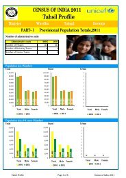
From the hazard map shown below, Deoli town in <strong>Wardha</strong> district falls under Low<br />
Damage Risk Zone (MSK VI) as far as earthquake is concerned and under Moderate Damage<br />
Risk Zone – A (44 m/s) as far as Wind and Cyclone is concerned.<br />
20