March 10.indd - ANPS
March 10.indd - ANPS
March 10.indd - ANPS

Create successful ePaper yourself
Turn your PDF publications into a flip-book with our unique Google optimized e-Paper software.
<strong>March</strong>, 2010<br />
NEWSLETTER OF THE AUSTRALIAN NATIONAL PLACENAMES SURVEY<br />
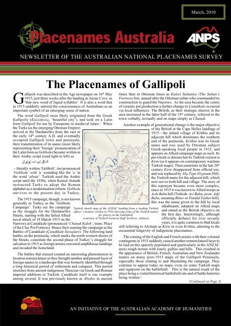
The Placenames of Gallipoli<br />
Gallipoli was described in the Age newspaper on 16 th May<br />
1915, just three weeks after the landing at Anzac Cove as<br />
‘that new word of liquid syllables’ It is also a word that<br />
in 1915 suddenly entered the consciousness of Australians as an<br />
important symbol of an emerging sense of nation.<br />
The word Gallipoli most likely originated from the Greek<br />
Kallipolis (Καλλίπολις, ‘beautiful city’), and took on a Latin<br />
form Gallipoli for use by Europeans in medieval times. 1 When<br />
the Turks (as the emerging Ottoman Empire)<br />
arrived at the Dardanelles from the east in<br />
the early 14 th century A.D. and eventually<br />
occupied Gallipoli town and peninsula,<br />
their transliteration of its name (most likely<br />
representing their ‘foreign’ pronunciation of<br />
the Latin form as Gelibolu) became written in<br />
their Arabic script (read right to left) as<br />
—literally written ‘Geliboli’, but pronounced<br />
‘Gelibolu’ with ‘u’ sounding like the ‘a’ in<br />
the word ‘about’. Turkish used the Arabic<br />
script until the 1930s, when Kemal Ataturk<br />
instructed Turks to adopt the Roman<br />
alphabet as a modernisation reform. Gelibolu<br />
survives to the present day in Turkey.<br />
The 1915 campaign, though, is not known<br />
generally in Turkey as the ‘Gelibolu<br />
Campaign’. Turks see the campaign<br />
as the struggle for the Dardanelles<br />
Straits, starting with the failed Allied<br />
naval attack of 18 <strong>March</strong> 1915 on the<br />
Narrows at Çanakkale (pronounced ‘Chanak Kaleh’, trans: Place<br />
of the Clay Pot Fortress). Hence their naming the campaign as the<br />
Battles of Çanakkale (Çanakkale Savaşları). The following land<br />
battles on the peninsula, which marks the north western shores of<br />
the Straits, constitute the second phase of Turkey’s struggle for<br />
salvation in 1915 as foreign armies executed amphibious landings<br />
and invaded the homeland.<br />
The battles that ensued created an interesting phenomenon in<br />
location nomenclature as they brought another and present layer of<br />
foreign names to a landscape that was formerly identifi ed through<br />
a long historical period of settlement and conquest. This period<br />
stretches from ancient indigenous Thracian via Greek and Roman<br />
imperial additions to Turkish. Çanakkale itself is one example<br />
among several. It was previously known as Abydos in ancient<br />
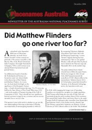
Turkish sketch map of the ANZAC landing from a leading Turkish<br />
offi cer’s memoir written in 1934 showing some of the Turkish names<br />
for places on the battlefi eld.<br />
(courtesy of Turkish General Staff Archives, Ankara)<br />
times then in Ottoman times as Kaleyi Sultaniye (The Sultan’s<br />
Fortress) fort, named after the Ottoman sultan who commanded its<br />
construction to guard the Narrows. As the area became the centre<br />
of ceramic pot production a further change to Çanakkale occurred<br />
via local infl uences. The British, as their strategic interest in the<br />
area increased in the latter half of the 19 th century, referred to the<br />
town verbally, textually and on maps simply as Chanak.<br />
Another example of generational change is the major objective<br />
of the British at the Cape Helles landings of<br />
1915—the inland village of Krithia and its<br />
adjacent hill which dominates the southern<br />
end of the peninsula. Krithia was its Greek<br />
name and was used by Ottoman subject<br />
Greek-speaking local people in 1915, and<br />
appears on Allied campaign maps as such. Its<br />
pre-Greek is obscure but its Turkish version is<br />
Kirte (as it appears on contemporary wartime<br />
Turkish maps). Then sometime in the late 20 th<br />
century Kirte disappeared from offi cial use,<br />
and was replaced by Alçı Tepe (Gypsum Hill),<br />
the Turkish name for the adjacent hill, which<br />
now serves both hill and village. The story of<br />
this toponym became even more complex,<br />
since in 1915 it was known to Allied troops as<br />
Achi Baba hill (Turkish: Aci Baba, pron. Adji<br />
Baba, meaning Bitter or Painful Father hill);<br />
this was the name given to the hill by local<br />
inhabitants, adopted on Allied maps<br />
and stated as the British objective on<br />
the fi rst day. Interestingly, although<br />
officially defunct for over seventy<br />
years, it is quite common to fi nd locals<br />
still referring to Alcitepe as Kirte or even Krithia, attesting to the<br />
occasional longevity of indigenous placenames.<br />
The coming of the English and French armies with their colonial<br />
contingents in 1915 suddenly caused another nomenclatural layer to<br />
be laid on this sparsely populated and (particularly in the ANZAC<br />
area) rough terrain with lonely gullies and hills. This resulted in<br />
the appearance of British, French, Australian and New Zealander<br />
names on many post-1915 maps of the Gallipoli Peninsula,<br />
especially those relating to and illustrating the campaign. They<br />
continue to appear today on maps, even on some Turkish maps<br />
and signposts on the battlefi eld. This is the natural result of the<br />
place being a visited historical battlefi eld site and of battle histories<br />
being written. 2<br />
(Continued on Page 3)<br />
AN INITIATIVE OF THE AUSTRALIAN ACADEMY OF HUMANITIES
From the editor . . .<br />
Dear Readers,<br />
In this <strong>March</strong> issue, with Anzac Day not far away, we feature a major<br />
article on Gallipoli placenames by Harvey Broadbent of Macquarie<br />
University, Sydney. We then turn to rather more distant fi elds, with<br />
Brendan Whyte’s feature on the Oz-related toponymy of the planet<br />
Mars. Below you will fi nd our fi rst contribution from Keith Collicoat<br />
of Buderim, Queensland. We will tell you more about Keith in our<br />
next issue. Happy reading!<br />
Tricia Mack<br />
Letter to the Editor<br />
Dear Editor,<br />
As Caroline Gonda of St Catharine’s College, Cambridge, informs us in the<br />
London Review of Books (28 January), Mary Shelley saw a stage adaptation of<br />
Frankenstein in 1823, in which Frankenstein’s creature was simply referred to<br />
as -------. Afterwards, in a letter to Leigh Hunt, she expressed approval of ‘this<br />
nameless mode of naming the unnameable’.<br />
Coming across a reference to Mount Nameless in Western Australia prompts<br />
me to ask whether anyone has considered the signifi cance of acts of naming which<br />
appear to contradict themselves, or perhaps to shrink from the consequences of<br />
trying to name ‘the unnameable’.<br />
I don’t think this kind of name can be said to produce a full-blown paradox<br />
(such as ‘This sentence is false’) unless we are prepared to say that an act of<br />
naming presupposes the utterance of a sentence. But can anyone tell us why the<br />
evasions and ironies lurking in such no-names are so persistently intriguing?<br />
Comments would be welcomed.<br />
John Miles<br />
Cherrybrook NSW<br />
Conference in Edinburgh<br />
Trends in Toponymy<br />
Conference in Edinburgh<br />
28 June – 1 July 2010<br />
We remind all our readers of this conference to be held in beautiful<br />
Edinburgh this northern summer. <strong>ANPS</strong> people will be there in force: Laura<br />
Kostanski is giving a keynote address on the Grampians; and others attending<br />
and giving papers are Ian Clark, and Michael Walsh. For further details, see<br />
http://www.delc.ed.ac.uk/conferences/TOPONYMYCONFERENCE.html<br />
The Shire of Banana, a “Local Government Area” of 28,577<br />
square kilometres, is located in the Capricorn region of Central<br />
Queensland west of Gladstone.<br />
The Shire gets its name from an old dun working<br />
bullock (named “Banana” because of his colour)<br />
which was used, on the Rannes pastoral run, as a<br />
decoy to “lead” wild cattle into yards when mustering.<br />
The bullock died and his body was taken to a nearby<br />
gully which became known as “Banana’s Gully”.<br />
Later a town, established near there, became known as<br />
Banana and when the fi rst Council sat there the Shire<br />
was named Banana. This sculpture stands in front of<br />
the Banana State School.<br />
The Shire of Banana<br />
Published by Placenames Australia (Inc.) ISSN: 1836-7968 (print) 1836-7976 (online)<br />
ABN 39652752594<br />
Contact: Editor: Tricia Mack, c/- <strong>ANPS</strong>, Linguistics Dept., Macquarie University NSW 2109<br />
Email: editor@anps.org.au<br />
Placenames Australia . <strong>March</strong> 2010 . Page 2<br />
In this issue<br />
The Placenames of Gallipoli ........................1<br />
From the Editor ............................................2<br />
Australian Placenames on Mars ....................5<br />
Two unusual early names for<br />
the Australia Continent .................................6<br />
Placenames puzzle no. 33 ….....….…..........7<br />
Placenames Australia Membership ..............8<br />
Who’s doing What<br />
Our members are involved in various<br />
toponymy projects this quarter.<br />
David Blair has fi nished recording Captain<br />
Cook¹s placenames from his 1770 journal, and<br />
is preparing the material for publication as a<br />
chronological listing.<br />
Dale Lehner is still working on incorporating<br />
Ron Potter¹s database of South- East<br />
Queensland placenames into the <strong>ANPS</strong><br />
records.<br />
Jan Tent is continuing to work with David<br />
Blair on an effective and practical typology<br />
for Australian placename specifi cs; and with<br />
colleague Helen Slatyer, starting research on<br />
early European place-naming practices in the<br />
South Pacifi c.<br />
Joyce Miles is investigating placenames<br />
in the Orange-Cowra area, and beginning to<br />
work on some new WA data.<br />
Future issues will keep you up to date on the<br />
work of our staff and Research Friends.<br />
It became a Shire council, under the Local Authorities<br />
Act 1902, on 31 <strong>March</strong> 1903. The Shire has a population of<br />
13,489 (2006 Australian Bureau of Statistics Census) and<br />
Council “sits” in Biloela, population<br />
5752, the largest town in the shire.<br />
Check out the Comparative profi le<br />
Incorporating data from the 2001<br />
Census at; http://www.banana.qld.<br />
gov.au/docs/profiles/BananaShire_<br />
ComparativeProfi le.pdf.<br />
Keith Collicoat
(Continued from Page 1)<br />
The battalions of foreign soldiers who peopled the scrubby<br />
ridges and gullies spontaneously named their localities, and<br />
Australian and New Zealand names appeared at ANZAC as<br />
did English and French ones in the Helles sector. Preparations<br />
of trench maps or operational orders required fi xed names<br />
and these became the new foreign names for the landscape<br />
that exist to this day. The Sphinx, a prominent rocky outcrop<br />
overlooking the Anzac Cove area, is a good example of this, so<br />
named because it reminded the troops of the original in Egypt<br />
from where they had most recently come.<br />
Prior to the campaign the placenames on the peninsula were<br />
mostly Turkish. They were for the most part confi ned to such<br />
features as:<br />
• villages (e.g. Maidos, Kojadere, Kirte, Anafarta Saghir),<br />
• creek courses, which in Turkish carried the term dere<br />
(pron. dereh), meaning valley or gully with a creek/<br />
stream, or dry creek bed, e.g. Asmak Dere (Vine Valley),<br />
Ziğindere (pron. Zighindereh)(Sharp Edged Gully),<br />
• and the most prominent ridges ( sirt) and spurs (bayir) e.g.<br />
Sari Bayir (Yellow Spur), Abdul Rahman Bayir (Abdul<br />
Rahman’s Spur or Ridge) and high hills (tepe -- pron.<br />
tepeh) e.g. Koja Chimen Tepe (Hill of the Great Pasture),<br />
Kaba Tepe (Rough Hill).<br />
It will be obvious that these gazetted names mostly represent<br />
either the nature of the landscape feature or are associated with<br />
an individual, such as a farmer or land owner.<br />
Other common Turkish placenames that existed were Büyük<br />
(large), Küçük, pron. Kuchuk (small), Burnu (Cape or Point),<br />
Dağ, pron. Dagh (Mountain), Kale (Fort). Kuyu (Well), Ova<br />
(Plain), Tekke (Shrine, originally a dervish lodge).<br />
Some of these names, appearing on Turkish maps, became<br />
features with which the Allied armies at Gallipoli were to<br />
become familiar. They were to be transliterated from the Arabic<br />
alphabet into the Roman alphabet and appear on the Allied<br />
campaign maps, most of which incidentally were to prove<br />
inadequate in scale and detail for successful battle planning.<br />
Even so, some of these locations became battle objectives and<br />
as such acquired a numerical Allied military description along<br />
with their Turkish names. A case in point was Koca Çimen<br />
Tepe (pron. Koja Chimen Tepe) (Hill of the Big Pasture) at<br />
the ANZAC landing, which was designated as Hill 971 (i.e.<br />
971 feet above sea-level), the main objective of the ANZACs<br />
on the fi rst day. 3<br />
The arrival of military forces, both Allied and Ottoman, on<br />
the peninsula resulted in most of the strategically important<br />
hills or elevated sections of landscape being designated with a<br />
number that indicated their height above sea level. The Allies<br />
used the ‘imperial’ feet, the Ottomans used metres. Hence the<br />
400 Plateau, Hill 60, Hill 14 and later in the campaign, alongside<br />
Suvla Bay, even Hill 10, hardly a hill at all but high enough to<br />
hold a Turkish machine gun platoon in a dominant position,<br />
which had to be cleared to enable the new British landings to<br />
take place unmolested.<br />
Not all Turkish-named locations were given numerical<br />
designations by the Allies; some were called by their Anglicised<br />
transliterations. Sari Bayir for example became ‘Sari Bair’, and<br />
Conkbayir (the joint summit point on the Sari Bair ridge and<br />
main objective with its partner summit, Hill 971) later became<br />
the renowned ‘Chunuk Bair’, taken by the New Zealanders in<br />
the August offensive and then re-taken from the Allies two days<br />
later in bloody fi ghting. Other examples of places that the Allies<br />
called by their pre-existing Turkish names are the Aghyl Dere<br />
Placenames Australia . <strong>March</strong> 2010 . Page 3<br />
Gallipoli . . .<br />
(Sheepfold Valley), Asmak Dere (Vine Valley), Kiretch Tepe<br />
(Lime or Chalky Hill) Tekke Tepe (Shrine Hill), and Kerevez<br />
Dere (Celery Valley).<br />
Other than the failed Allied objective of Hill 971, perhaps<br />
the best-known numerically-named feature is Baby 700. This<br />
feature, lying en route up the second ridge towards Hill 971 and<br />
south of it, was an intermediate hill that had to be taken before<br />
Hill 971 could be attacked. It was almost taken by the advanced<br />
units of the ANZACs on the fi rst day, but successfully defended<br />
by the newly-arrived Ottoman reserve force and held by the<br />
Turks for the rest of the campaign. On the 25th April, though,<br />
the Allies designated it Hill 700 only to discover it had two<br />
humps, one slightly higher, so two names were quickly applied<br />
to differentiate the locations: Big 700 and Baby 700.<br />
The name Big 700 only lasted a few days, as a more suitable<br />
name for the hill ensued after it became the target for British<br />
naval artillery—Battleship Hill. The name also denotes a facet<br />
of the battle itself in that British naval guns could not easily<br />
penetrate Turkish land defence emplacements in many places,<br />
most of which were purposely deployed in gullies and lees<br />
which could not be reached by the fl at trajectories of naval<br />
guns. Targets for naval guns had to be in sight: Battleship<br />
Hill, being one such exposed hill on its seaward side, was in<br />
Turkish hands and any Turkish wide frontal attack against the<br />
ANZAC line would have to take place over it. Destroyer Hill,<br />
a small hill overlooking the Sazli Beit Dere (Seaweed Valley),<br />
often heavily shelled by destroyers, was another such exposed<br />
feature duly named.<br />
Such tactical concerns and incidents in the battle for the<br />
Gallipoli Peninsula were the stimulus for the imposing of<br />
European (mainly English) names on the topography. Further<br />
examples of this genre of toponyms are Shrapnel Gully, Shell<br />
Green and Hell Spit—all named as a result of their susceptibility<br />
to Turkish artillery fi re. Others taking their inspiration from<br />
the often bloody battle events are:<br />
• Dead Man’s Ridge, where the bodies of ANZACs and<br />
men of the Royal Naval Division lay from May 2/3 until<br />
the Armistice of 24 May;<br />
• the nearby Bloody Angle—named after the 4th<br />
Australian Brigade and units of the Royal Naval<br />
Division suffered heavy losses there on May 2/3;<br />
• Sniper’s Nest, a scrubby hill from which Turkish snipers<br />
made North Beach vulnerable to enemy fi re and unsafe<br />
for traffi c;<br />
• the Valley of Despair, on the extreme ANZAC right<br />
fl ank, always in Turkish hands.<br />
Geographical appearance and battlefield features also<br />
provided another genre of names. Lone Pine is perhaps the best<br />
known example and the most famous spot after ANZAC Cove.<br />
It was so named because in the fi rst few days of the campaign<br />
a single pine tree marked the No-Man’s Land spot where the<br />
Australian and Turkish front lines battled it out on the right<br />
fl ank. The original name given by the men was the Lonesome<br />
Pine, the inspiration coming from a popular song of the period.<br />
The tree was destroyed by artillery fi re within a few days but<br />
the name of the position survived. In the August Offensive the<br />
front line of Turkish trenches at Lone Pine was taken by the<br />
Australians earning them seven Victoria Crosses.<br />
The following are further illustrations of this genre:<br />
• The Nek, one of the most notorious of positions—a<br />
narrow stretch of No Man’s Land, connecting Russell’s<br />
Top to Baby 700 and the forward Turkish trenches,<br />
which was the scene of the deadly dismounted Australian<br />
Light Horse charge in August;<br />
(Continued on Page 4)
• Rhododendron Ridge (or Spur), leading up to Chunuk<br />
Bair from the west and named by New Zealander, Major<br />
Overton, after the local arbutus that he saw as resembling<br />
the rhododendron;<br />
• The Apex, the highest point on Rhododendron Ridge;<br />
• Camel’s Hump, a Turkish position below Sniper’s<br />
Nest;<br />
• The Chessboard, a criss-cross network of Turkish<br />
trenches inland from the Nek;<br />
• Chocolate Hill, a brownish red scrubby hill inland from<br />
Suvla Bay, its colour later even browner after it was<br />
swept with fi re;<br />
• Green Hill, adjacent to Chocolate Hill;<br />
• The Cornfi eld,<br />
a small patch of cultivated ground just<br />
above Shell Green;<br />
• The Daisy Patch, a piece of old meadow at Cape Helles<br />
and scene of a particularly heroic and costly failed attack<br />
by New Zealand units;<br />
• Happy Valley, just north of Walker’s Ridge so-called<br />
because in the early days, when it was spring, the lower<br />
area was a mass of fl owering shrubs and soft grass fi lled<br />
with the fragrance of wild thyme;<br />
• Scrubby Knoll,<br />
the Turkish command position on the<br />
northern end of the third ridge, where Lieutenant-<br />
Colonel Mustafa Kemal set up his Field H.Q. The Turks<br />
named the spot prosaically Kemalyeri (Kemal’s Place<br />
or Position);<br />
• Table Top, a fl at-topped hill, at the foot of Rhododendron<br />
Ridge captured by the Wellington Mounted Rifl es on the<br />
night of August 6/7;<br />
• The ‘W’ Hills,<br />
the name given to the original Turkishnamed<br />
ridge of Ismail Oglu Tepe about a mile due north<br />
of Hill 60—when viewed from Russell’s Top, to the<br />
south, the ridge appears in the shape of a ‘W’.<br />
By far the most common genre of battlefi eld placenames<br />
remains those called after individuals, usually commanders<br />
and offi cers, who either made their local HQs in these places<br />
or who distinguished themselves in some way at those points.<br />
Monash Valley is perhaps the best known. It is named after<br />
Australian 4th (Continued from Page 3)<br />
Brigade Commander, the renowned John Monash,<br />
who led his brigade to occupy the head of the valley at the<br />
end of the fi rst day. Equally well-known is the fi rst ridge high<br />
above ANZAC Cove, known as Plugge’s Plateau (pronounced<br />
Pluggey’s) and named after Arthur Plugge, the commander of<br />
the Auckland Infantry Battalion, who made the area his H.Q. for<br />
a short while on the afternoon of the fi rst day before receiving<br />
wounds. Space prevents a full explanatory list of place-names<br />
and it must suffi ce to mention a few:<br />
•<br />
Ba Bau Bauchop’s Hill (Colonel of the Otago Rifl es);<br />
•<br />
Bo Bolton’s Hill (Colonel, 8th Australian Infantry<br />
Ba Bat Battalion);<br />
•<br />
Br BBraund’s a Hill (Colonel 2nd Australian Infantry<br />
Ba Bat Battalion);<br />
•<br />
Br Bri Bridges’ Road (leading from Shrapnel Valley towards<br />
Wi Wir Wire Gully, named in memory of General Bridges, the<br />
Au Australian Divisional Commander, who was mortally<br />
wo wou wounded in Shrapnel Valley);<br />
•<br />
Ch CChatham’s<br />
Post (Lieutenant, 5th Australian Light<br />
Ho Hor Horse);<br />
•<br />
Co Cou Courtney’s Post (Lt. Col., 14th Australian Infantry<br />
Ba BBattalion); t<br />
•<br />
Jo John Johnston’s hn hnst ston on’s ’s Jolly, JJol<br />
o ly ly, (Colonel (C ( ol olon on onel el e G. . J. J Johnston, Brigadier<br />
of the tthe<br />
he 2nd 22nd<br />
nd Aus AAustralian<br />
us ustr tr tralia ia i n Ar Arti Artillery ti till ller ery y Brigade, named after<br />
Jo John Johnston’s hn hnst st ston on on’s ’s frequent f ffre<br />
requ qu q en ent re rremarks ma m rk rks k ab aabout o ‘jollying along’ the<br />
Tu Turk Turks rk rks s wi with<br />
th h hhis<br />
is a aart<br />
artillery); rt rtil il ille le lery ry ry); );<br />
•<br />
Ma MMalone’s lo l ne n ’s G GGul<br />
Gully ul u ly ( (the th the e ga ggallant ll llan ant t Co CColonel lo l of the Wellington<br />
In IInfantry fa f nt ntry ry r B BBat<br />
Battalion); at a ta tali li l on on); );<br />
•<br />
Ma MMaclaurin’s cl clau au auri ri r n’ n’s s Hi HHill ll ( (Co (Colonel, Co Colo lo l ne nel, l, l tthe<br />
the he Brigadier of the 1st<br />
Au Australi Australian li l an IInf<br />
Infantry nf nfan an antr tr t y Br Brig Brigade, ig igad ad ade, e, wwas<br />
was as killed in Monash Gully<br />
tw two<br />
o da days<br />
ys y a aaft<br />
after ft f er e t tthe<br />
the he h landi landing); di d ng ng); );<br />
rd r<br />
•<br />
Ma MMacLagan’s cL cLag ag agan an a ’s Rid Ridge id idge ge (Aust ( (Australian st stra ra rali li lian an 3<br />
3<br />
Brigade Commander,<br />
the th t e ma man<br />
n in ccha<br />
charge harg rg r e of the fi rst<br />
st landings); lan an a<br />
• MaCay’s Ma M Ca Cay’ y’ y s Hi Hill<br />
ll (Co (Colonel, Colo l nel, the<br />
he BBrigadier<br />
of the 2nd<br />
Australian Au Aust st stra ra rali li lian an a IInfan<br />
Infantry a tr try y Br BBrigade, igad ad ade, e, e t tthe<br />
h commander of the<br />
second se s co cond nd n wave at the<br />
he landi landing); di ding n ); )<br />
• Quinn’s Qu Q in inn’ n’ n s Post Po Post st (Major (Majo jor r Quinn, Qu Q in i n, the t<br />
tthe<br />
he 15th 1 Australian Infantry<br />
Battalion, Ba B tt ttal al a io i n, wwho<br />
who was kil killed il ille le l d de ddefending fe f nd the post);<br />
• Steel’s St S ee e l’ l’s s Po PPost st s (Ma (Major Ma M jo j r St SSteel, ee eel, l, of oof<br />
the 14th Australian<br />
Battalion). Ba B tt t al alio io ion) n) n).<br />
In their own naming of battle fi eld places, the Turks refrained<br />
from any aggrandisement of individual commanders, apart<br />
from Mustafa Kemal (at Kemalyeri), probably because it was<br />
the main Ottoman fi eld HQ position. In the fi rst weeks of<br />
the campaign, Turkish orders, reports and signals referred to<br />
locations and targets by their existing names if they appeared<br />
on existing maps. ANZAC Cove was already named by its two<br />
promontories as Ariburnu (Bee Point) and Küçük Ariburnu<br />
(Little Bee Point) and so they remained. The major ANZAC<br />
objective Koca Çimen Tepe (Hill 971) also remained in currency<br />
as did other existing names e.g. Yüksek Sırt (High Ridge)<br />
(Russell’s Top), Mestantepe (Drunken Hill) (Chocolate Hill).<br />
If names did not exist the crucial places were designated in the<br />
early periods by altitude designations e.g. “Hill with the Altitude<br />
120” (i.e. 120 metres). This was a military procedure and, as<br />
mentioned, was also utilised by the Allies in places. But later<br />
in the campaign prosaic Turkish names for locations where<br />
action was centred began to appear in both Ottoman verbal and<br />
written communications and orders.<br />
While avoiding geographical and personal names, the<br />
Turks often adopted descriptive toponyms or names echoing<br />
the sentiment of battle, and these frequently had their less<br />
colourful Australian, English or French equivalents. Plugge’s<br />
Plateau went from being Hill with Altitude 105 (approx.) to<br />
Hain Tepe (Traitor Hill), Lone Pine went from being Hill with<br />
Altitude 140 (approx.) to Kanlı Sırt (Bloody Ridge), Quinn’s<br />
Post went from having no name to Bomba Sırt (Bomb Ridge),<br />
and Monash Valley became Korku Dere (Valley of Fear). The<br />
important Allied objective Chunuk Bair did not originally<br />
have a designated name, but early references are as Hill with<br />
the Altitude 220. It is only much later in the campaign that it<br />
becomes referred to as Conk Bayir (Hill of War). The Third<br />
Ridge had no given Turkish name, but soon became known as<br />
Topçucular Sirt (Gunner’s Ridge) as did its similar English<br />
name, Gun Ridge.<br />
This is not the place to offer an exhaustive gazetteer with<br />
background explanations of Gallipoli Campaign placenames—<br />
it would require a small book to do justice to the task. But as<br />
a conclusion I list, alongside their English equivalents, a few<br />
more of the most prominent Turkish names that have found<br />
their way on to Turkish maps depicting the campaign.<br />
Al Bayrak Sırt (Red Flag Ridge) Pine Ridge<br />
Boyun (The Neck/Defi le) Courtney’s Post<br />
Çakal (Chakal) Dere (Jackal Gully) Clarke Valley<br />
Placenames Australia . <strong>March</strong> 2010 . Page 4<br />
Gallipoli . . .<br />
(Continued on Page 7)
Australian Placenames on Mars<br />
The red dust of Mars is not unlike that of the Australian<br />
outback, so it is somehow fi tting that two aboriginal place<br />
names, Canberra and Woomera, have been ascribed to<br />
features on the Red Planet.<br />
American exploration of Mars (the Russians concentrated on<br />
Venus) began with the Mariner 4, launched in 1964 and which<br />
sent back 21 scanning TV images in 1965 when it passed less<br />
than 10,000 km from Mars. This was followed by Mariner 9<br />
which went into orbit around the planet in late 1971 during a<br />
massive dust storm. When the storm abated in early 1972, 70%<br />
of the planet’s surface was imaged, and landing sites selected<br />
for the upcoming Viking programme. The two Viking craft,<br />
each consisting of orbiter and lander modules, were launched<br />
in August and September 1975, and reached the Martian surface<br />
on 20 July and 3 September 1976 respectively, after year-long<br />
journeys. The landers analysed soil samples for signs of life, but<br />
returned negative results. The Viking missions were milestones<br />
in space exploration, but for all their success, it was over 20<br />
years before the next landing on Mars, when the Mars Pathfi nder<br />
mission of 1996-7 landed the mobile robotic Sojourner unit<br />
(Furniss 2001:212-220)<br />
The published results of the Viking missions include two<br />
controlled photomosaic maps, at a scale of 1:250,000, centred<br />
on the landing sites of each Viking lander: the Yorktown and<br />
Canberra regions (USGS 1977a&b). Each map includes detailed<br />
notes on the left side explaining the projection, control and image<br />
processing used, as well as the adopted nomenclature.<br />
On the Canberra sheet (USGS 1977b), the Nomenclature<br />
notes state:<br />
The Viking mission was planned, in part, to honour the<br />
bicentennial celebration of the United States of America<br />
(1776-1976) and the names chosen for the two Viking maps<br />
at a scale of 1:250,000 honour this event. Names on the fi rst<br />
Viking landing site map commemorate the thirteen American<br />
colonies and the ports and countries that traded with them<br />
and from which expeditions originated in 1776. Names on the<br />
second Viking landing site map honour the launch facilities,<br />
tracking stations, and mission control centres concerned with<br />
the exploration of space in 1976, including the Viking mission.<br />
A table of place names used on the map is then given:<br />
Name Na Name me Reference Country<br />
Baykonyr Baykonyr Launch site USSR<br />
Canaveral Ca C naveral Launch site USA<br />
Canberra Tracking station Australia<br />
Evpatorya Evpatorya Tracking station USSR<br />
Goldstone Tracking station USA<br />
Hamaguir Ha Hama ma magu gu guir ir La Laun Launch un ch h ssit<br />
site it ite Al Alge Algeria ge geri ria i<br />
Houston Ho Hous us usto to ton Mission Mi Miss ss ssio io ion Control CCon<br />
on ontr tr trol ol USA US USA<br />
Hsüanch’eng Hs H üanch’eng Launch site China<br />
Johannesburg Tracking station South Africa<br />
Jodrell Jo Jodr drel ell Tr Trac Tracking acki king ng ssta<br />
station tati tion on UK<br />
Kagoshima Launch site Japan<br />
Kaliningrad Mission Control USSR<br />
Kourou Launch site French Guiana<br />
Madrid Madrid Tracking station Spain<br />
Tsukuba Mission Control Control Japan<br />
Volgograd Launch site USSR<br />
Wallops Launch site USA<br />
Woomera Launch site Australia<br />
Placenames Australia . <strong>March</strong> 2010 . Page 5<br />
All these features are craters and all the names were all<br />
approved by the International Astronomical Union in 1979.<br />
Canberra crater is about 3.25 km in diameter, and centred on<br />
47.5° N, 227.4° W (Martian coordinates utilise latitudes from<br />
0 to 90° north and south, but a single longitude of 0 to 360°<br />
measured westwards). The derivation of the word Canberra<br />
is obscure. It was fi rst recorded in 1826 when Joshua Moore<br />
wrote to the Colonial Secretary advising that land he wished<br />
to purchase was at ‘Canberry’. Some sources suggest this is<br />
an Anglicization of nganbirra, meaning ‘meeting place’ in<br />
reference to seasonal corroborees held in what is now the ACT<br />
to feast on Bogong moths. Other sources suggest the word<br />
derives from kaamberra possibly meaning ‘women’s breasts’,<br />
possibly in reference to Black Mountain and Mt. Ainslie<br />
(Appleton & Appleton 1992, 55; Reed 1967:25). Whatever the<br />
name’s origin, in the 1960s NASA built three tracking stations<br />
in the ACT close to Canberra. These were Orroral Valley<br />
(1965-85), which supported orbiting satellites, as well as the<br />
Apollo-Soyuz Test Project and the space shuttles; Tidbinbilla<br />
(1965-present), which was used for tracking the Apollo Lunar<br />
Module; and Honeysuckle Creek (1967-81), which supported<br />
the Apollo moon missions, mainly communicating with the<br />
Apollo command module, Skylab, until that satellite fell to earth<br />
in 1979, and fi nally Viking and Voyager projects. The Canberra<br />
on Mars honours these three tracking stations.<br />
Mars’ Woomera crater, 50 km due north of Canberra, is<br />
about 2.5 km in diameter, and centred at 48.4°N, 227.4°W. It<br />
was named for the ‘secret’ town of Woomera in outback South<br />
Australia, which was developed during the Cold War as a centre<br />
for various British, and later European and American rocketry<br />
experiments. In addition, over the years NASA and the USAF<br />
had several tracking stations in the vicinity of the town including<br />
Island Lagoon (1960-72), and Nurrungar (1969-99). Woomera<br />
is an eastern aboriginal word meaning spear-thrower. Ironically<br />
the indigenes of what became the Woomera area had a different<br />
word for this implement: miru. ‘Woomera’ was chosen from<br />
an aboriginal glossary by N.H .Freeson of the RAF and George<br />
Pither of the RAAF in 1947. Pither passed the suggestion to Air<br />
Marshall E.C. Wackett, the RAAF’s representative on the board<br />
of the Long Range Weapons Establishment which was building<br />
the site, and the board adopted the name on 24 April 1947. An<br />
earlier proposed name, Red Sands (an antipodean tip of the<br />
hat to the White Sands range in New Mexico (Morton 1997:<br />
117)), was ruled out, but would have been highly appropriate<br />
for subsequent transferral to Mars!<br />
Both the Yorktown and Canberra maps of Mars can still be<br />
purchased from the USGS for US$9 each:<br />
U.S. Geological Survey Information Services<br />
Box 25286<br />
Federal Center<br />
Denver, CO 80225<br />
USA<br />
http://store.usgs.gov<br />
© Brendan Whyte<br />
Assistant Curator of Maps<br />
National Library of Australia<br />
References:<br />
Appleton, R. & Appleton, B., 1997, The Cambridge Dictionary<br />
of Australian Placenames, Cambridge University Press,<br />
Cambridge.<br />
Furniss, Tim, 2001, The History of Space Vehicles, Grange Books,<br />
Hoo (Kent).<br />
Morton, Peter, 1989 reprinted 1997, Fire Across the Desert, Woomera<br />
and the Anglo-Australian Joint Project 1946-1980, Department<br />
of Defence, Canberra.<br />
(Continued on Page 7)
Two unusual early names for the<br />
Australian Continent<br />
The continent of Australia had several appellations before<br />
its current name was unequivocally and universally<br />
adopted. These names included: Terra Australis<br />
(Incognita) (Unknown South Land), Nova Hollandia (New<br />
Holland), New South Wales 1 , Notasia, and Ulimaroa. Various<br />
sections of the coastline also had specifi c labels, e.g. G.F. de<br />
Witt’s Land, d’Edels Land, van Nuyts Land, Arnhem Land,<br />
Carpentaria, ‘t Land van Leeuwin, ‘t Land van d’Eendracht,<br />
Maria van Diemen’s Land, (Antonie) van Diemen’s Land, Terre<br />
Napoléon, Dampier’s Land, Dinning’s Land etc.<br />
Most of these appellations are well-known and their<br />
origins easily explained. However, two have remained<br />
unexplained – Ulimaroa and Notasia.<br />
Very little has been written on the<br />
meaning and origin of these names.<br />
Paul Geraghty and I are currently<br />
conducting research into the origin<br />
and meaning of the most enigmatic<br />
of this pair, Ulimaroa, and will<br />
feature as a separate article in a future<br />
issue of the Newsletter. In the mean<br />
time, I present a brief account of the<br />
meaning of Notasia.<br />
This name is used on a number<br />
of early nineteenth century maps of<br />
Australia, e.g. Lowry (1806), Scott<br />
(1811, 1817), Arrowsmith (1816),<br />
Norie (1816), Lapie (1817), Tardieu<br />
(1821), Rossi (1824), and Reichard<br />
(1827). 2 The name also appears<br />
in several literary and scholarly<br />
publications, as well as in the title of<br />
one of the earliest general histories<br />
of New South Wales, compiled from<br />
the written accounts of members of<br />
the First Fleet – Heroes of Notasia:<br />
a record of Australian exploration. 3<br />
The only attempt I have been able to<br />
unearth that attempts to explain the<br />
meaning of Notasia is in a 1927 letter<br />
by Arthur Wilberforce Jose to the Rev. A. J. Prowse. 4 During<br />
his life, Jose was a wood cutter, brick maker, author, historian,<br />
university lecturer, journalist, barrister, intelligence offi cer,<br />
and editor-in-chief of The Australian Encyclopaedia (1925,<br />
1926). 5 In his letter to Prowse, Jose explains that Notasia means<br />
‘Southern Asia’ and is derived from the Greek νοτος (notos)<br />
‘south; the south wind’. This seems a most valid explanation,<br />
especially given numerous contemporary maps labelled<br />
Australia by its Latin equivalent, Australasia.<br />
More in part 2, on the origin and meaning of Ulimaroa.<br />
Part 1<br />
References and footnotes:<br />
Australasia - National Library of Australia<br />
nla.map-rm2969-v<br />
1 When James Cook named the east coast of the continent,<br />
New South Wales, the entire continent was still known as<br />
New Holland. At the establishment of the fi rst British colony,<br />
in 1788, Governor Arthur Phillip proclaimed the name New<br />
South Wales for the eastern half of the continent (to 135° east);<br />
New Holland remained the name for the western half. In 1825,<br />
the western boundary of the colony was extended to 129° east.<br />
In 1831, New Holland was renamed Western Australia.<br />
2 Wilson Lowry, Australasia, in John Pinkerton, Modern<br />
Geography a Description of the Empires, Kingdoms, States,<br />
and Colonies… (London 1807); R. Scott, Australasia, in<br />
George Paterson, The History of New<br />
South Wales from its First Discovery to<br />
the Present Time… (Newcastle-upon-<br />
Tyne 1811) and Eneas Mackenzie, A<br />
New and Complex System of Modern<br />
Geography… (London 1817) http:nla.<br />
gov.au/nla.map-rm2969; Aaron<br />
Arrowsmith, Australasia (Edinburgh<br />
1816); John William Norie, [untitled<br />
map] (London 1816) http://nla.<br />
gov.au/nla.map-rm3381; Pierre<br />
Lapie, Australia Pacific Oeceanie<br />
ou Australasie et Polynesie (Paris<br />
1817); Ambroise Tardieu, Mappemonde<br />
en deux hémisphères dressée<br />
pour l’intelligence de l’Histoire<br />
générale des voyages de Laharpe, in<br />
J.F. La Harpe, Abrégé de l’histoire<br />
générale des voyages…(Paris 1821);<br />
Carlo Rossi, Oceania (Milan 1824)<br />
http://nla.gov.au/nla.map-t1009; and<br />
Christian G.T. Reichard, Oceanica<br />
(Polinesia) (Venice 1827).<br />
3 Robert Brown, Prodromus Florae<br />
Novae Hollandiae et Insulae Van<br />
Diemen (London 1810); Charles-<br />
Athanase Walckenaer, Cosmology, or,<br />
a General Description of the Earth…<br />
(Paris 1815); Thomas K. Hervey,<br />
Australia; with other Poems (London 1825) pp. x, 16, 30, 37;<br />
Jules Verreaux and Eduard Verruex, L’Oceanie en Estampes:<br />
ou description geographique et historique de... Notasie,<br />
Polynesie, Australie... (Paris 1832); ‘Dio’, Heroes of Notasia:<br />
a record of Australian exploration (Hobart 1888).<br />
4 Arthur Wilberforce Jose, Letter 14 Dec. 1927 to the Rev. A. J.<br />
Prowse (Queenstown, Tasmania) on the meaning of Notasia.<br />
Hayes Manuscript Collection, University of Queensland<br />
Library, Ref. UQFL2/1377.<br />
5 R. Lamont, ‘Jose, Arthur Wilberforce (1863 - 1934)’,<br />
Australian Dictionary of Biography, Volume 9 (Melbourne<br />
1983), pp 523-524.<br />
Placenames Australia . <strong>March</strong> 2010 . Page 6<br />
© Jan Tent
Placenames puzzle no. 33<br />
With References to Reading<br />
The clues reveal placenames with a literary reference<br />
(disregard spelling)<br />
E.g. (SA) Otherwise known as Mr Holmes ……..Sherlock<br />
1. (SA) The cargo also contained cedarwood and sweet white<br />
wine<br />
2. (SA) Home of Fanny Price<br />
3. (SA) Basil Hallward painted a portrait of Mr Gray<br />
4. (SA) Her police detective is Adam Dalgleish, settlement<br />
5. (NSW) The daughter of Prospero<br />
6. (NSW) He came out of the West to wed the fair Ellen<br />
7. (NSW) He’s in his hammock till the great Armadas come<br />
8. (NSW/SA/TAS) Goldsmith thought it was the loveliest<br />
village of the plain<br />
9. (ACT) Keats was ‘Silent, upon a peak in Darien’, when<br />
fi rst looking into this author’s translation of Homer<br />
10. (ACT/SA) From experience, he wrote of Tom’s education<br />
at Rugby<br />
11. (QLD) The noble lady from Malfi<br />
12. (QLD) According to Jack Higgins this large bird has landed;<br />
agricultural establishment<br />
13. (QLD) This son of Apollo lost his wife through looking<br />
back; land surrounded by water<br />
14. (VIC) It is right in the centre of Midlothian<br />
15. (VIC) The grandson of Nokomis<br />
16. (VIC) Pick one of these fl owers as time is passing<br />
17. (WA) Beneath this tree the party took place after the<br />
wedding of the tranter’s son Dick Dewey and Fancy Day<br />
18. (WA) The winter of discontent was made glorious by him<br />
19. (VIC/WA) Father of Goneril, Regan and Cordelia, one<br />
twelfth of a year<br />
20. (VIC/QLD) This 2009 Miles Franklin award winner took<br />
a deep breath<br />
© Joyce Miles 2010<br />
(Continued from Page 4)<br />
Answers:<br />
1. Sandalwood 2. Mansfi eld Park 3. Dorrien 4. Jamestown 5. Miranda 6. Lochinvar 7. Drake 8. Auburn<br />
9. Chapman 10. Hughes 11. Duchess 12. Eagle Farm 13. Orpheus Island 14. The Heart 15. Hiawatha<br />
16. Rosebud 17. Greenwood 18. York 19. Learmonth 20. Winton<br />
Placenames Australia . <strong>March</strong> 2010 . Page 7<br />
Gallipoli . . .<br />
Çukur (Chukur) Dere (Glen Valley) Australia Valley<br />
Düz (Düs) Tepe (Flat Hill) Battleship Hill<br />
Cesaret (pron. Jessaret)<br />
Tepe (Hill of Valour) The Nek<br />
Kara Dere (Dark Gully) Cooee Valley<br />
Karayürek Dere (Dark Heart Valley) Legge Valley<br />
Kirmizi Sırt (Red Ridge) Johnstone’s<br />
Jolly<br />
Pilav Tepe (Cooked Rice Hill) Table Top<br />
Şahin Sırt (Eagle Ridge) Rhododendron<br />
Ridge<br />
Süngü Bayir (Bayonet Spur) Chathams Post<br />
and Harris Ridge<br />
Yeşil Tarla (Green Meadow) Shell Green<br />
Harvey Broadbent is Senior Research Fellow in the<br />
Department of Modern History, Politics and International<br />
Relations at Macquarie University and Director of the<br />
ARC-funded Gallipoli Centenary Research Project, which is<br />
researching Turkish documentation of the campaign.<br />
References:<br />
1 There is a Gallipoli also in Italy. Professor Sam Lieu of Macquarie<br />
University is presently completing a book that includes his<br />
extensive research on the origins of the name and offers varying<br />
possibilities.<br />
2 Anzak Koyu (Anzac Cove) was offi cially gazetted on Turkish<br />
maps in 1985, the 70 th anniversary of the campaign, as a reciprocal<br />
arrangement with the Australian Government, which established<br />
Ataturk Park opposite the Australian War Memorial in Canberra<br />
and named a stretch of the coastline at Albany, W.A. as Ataturk<br />
Reach.<br />
3 An objective that was not achieved on the fi rst day nor in the eight<br />
months of the Anzac action at Gallipoli.<br />
Australian Placenames . . .<br />
(Continued from Page 5)<br />
Reed, A.W., 1967 reprinted 2000, Aboriginal Placenames, Reed New<br />
Holland, Sydney.<br />
United States Geological Survey, 1977a, Controlled mosaic of the<br />
Yorktown region of Mars (Viking 1 landing site) M 250 K<br />
22/48 CMC, Miscellaneous investigations series I-1059.<br />
Atlas of Mars 1:250,000 topographic series, prepared in<br />
cooperation with the Jet Propulsion Laboratory, California<br />
Institute of Technology for the Langley Research Center<br />
National Aeronautics and Space Administration. ISBN 978-<br />
0-607-78046-8. USGS product number 27022.<br />
United States Geological Survey, 1977b, Controlled mosaic of the<br />
Canberra region of Mars (Viking 2 landing site) M 250 K<br />
48/226 CM, Miscellaneous investigations series I-1060. Atlas<br />
of Mars 1:250,000 topographic series, prepared in cooperation<br />
with the Jet Propulsion Laboratory, California Institute<br />
of Technology for the Langley Research Center National<br />
Aeronautics and Space Administration. ISBN 978-0-607-<br />
78047-5. USGS product number 27023.
Placenames Australia...<br />
Become a Supporting S<br />
Member!<br />
We realise that not everyone who wishes to support the Australian National Placenames Survey can do so by carrying out<br />
toponymic research and supplying information for our database. There IS another way—become a Supporting Member of<br />
Placenames Australia! In doing so, you’ll help the Survey and its volunteer researchers by providing infrastructure support.<br />
In return, you’ll have the assurance that you’ll be helping ensure the continued existence of this prestige national project,<br />
and we’ll guarantee to keep you in touch by posting to you a printed copy of this quarterly newsletter.<br />
The Survey has no funding of its own—it relies on the generosity of its supporters, both corporate and individual. We will<br />
try to maintain our current mailing list, as long as we can; in the long term, priority will be given to Supporting Members of<br />
the association, to our volunteer Research Friends, to public libraries and history societies, and to media organizations.<br />
Please consider carefully this invitation. If you wish to become a Member, write a cheque to Placenames Australia Inc, or<br />
arrange a bank transfer, and post this page to the Secretary at the address below.<br />
To ensure your continued receipt of the Newsletter, even if you are unable at this time to support <strong>ANPS</strong> by becoming a<br />
Member, please take time to tick the appropriate box below and return this form to the Secretary.<br />
Dr Jan Tent, Placenames Australia<br />
Linguistics Department<br />
MACQUARIE UNIVERSITY NSW 2109<br />
Fax: (02) 9850 9199 Email: director@anps.org.au<br />
Name and/or Organisation:………………………………………<br />
……………………………………………………………………<br />
……………………………………………………………………<br />
Address:………………………………………………………….<br />
……………………………………………………………………<br />
Phone:……………………….. Fax:…………………………….<br />
Email:…………………………………………………………….<br />
� I am unable to become a Member at this time, but please keep me on the h newsletter l mailing ili li list<br />
and send me newsletters � by post OR � by email<br />
� Please remove me from the newsletter mailing list<br />
� Please note my change of address (new address above)<br />
We say<br />
thankyou to…<br />
our corporate sponsor, the Geographical<br />
Names Board of NSW—and to the Secretary<br />
of the Board, Greg Windsor. This<br />
year’s newsletters<br />
could not have been<br />
published without<br />
the support of the<br />
GNB.<br />
Contributions<br />
� I wish to become a Member of<br />
Placenames Australia (individual)—my<br />
cheque/transfer for ……………..…….$25<br />
OR<br />
� We wish to become a Member of<br />
Placenames Australia (organisational/<br />
corporate)—our cheque/transfer for...$250<br />
Date ...........................<br />
� Cheques made out to Placenames<br />
Australia. ABN 39652752594<br />
� Direct tranfer to Bendigo Bank:<br />
BSB 633 108, a/c 131212649<br />
Contributions for Placenames Australia are welcome.<br />
Please send all contributions to the Editor, Tricia Mack,<br />
by email: editor@anps.org.au<br />
Electronic submissions and photographic or other illustrations are greatly<br />
appreciated.<br />
Closing dates for submission are:<br />
31 January for the <strong>March</strong> issue 31 July for the September issue<br />
30 April for the June issue 31 October for the December issue<br />
Placenames Australia . <strong>March</strong> 2010 . Page 8