
Create successful ePaper yourself
Turn your PDF publications into a flip-book with our unique Google optimized e-Paper software.
History of “The <strong>Beach</strong>”<br />
<strong>Wasaga</strong> <strong>Beach</strong> and its surrounding area was first occupied by the<br />
Algonquin Indians. The word Nottawasaga is an Algonquin word.<br />
Nottawa means Iroquois and Saga means “mouth of the river”. The<br />
Algonquin Indian Scouts, when posted at lookouts along the river,<br />
would pass along the word Nottawasaga if they saw Iroquois raiding<br />
parties approaching. This meant “Iroquois at the mouth of the river”.<br />
(Information taken from the on-line Ojibwa-English Dictionary)<br />
In the early 1800’s, Upper Canada was drawn into the struggle<br />
between Great Britain and the United States. As the most accessible<br />
and vulnerable part of the British Empire, Upper Canada was to bear<br />
the brunt of the American attack. As we all learned in school, the<br />
United States declared war on Great Britain in 1812.<br />
The British had early success controlling the Great Lakes during that<br />
war, but on September 9, 1813, a battle between six British and nine<br />
American ships took place on Lake Erie. This battle saw the capture<br />
of all six British ships, with the Americans gaining control of the<br />
Upper Great Lakes. The last surviving British ship of any significance<br />
was the British Schooner The Nancy, a fur-trading vessel that was<br />
pressed into service during the war.<br />
On August 13, 1814, three American ships arrived at the mouth of<br />
the Nottawasaga River, and found The Nancy hidden up river. The<br />
Nancy was subsequently sunk and the mouth of the river was<br />
blocked with debris by the enemy, which shut down the supply route.<br />
Georgian Bay Optometry Clinic<br />
1026 Mosley Street, <strong>Wasaga</strong> <strong>Beach</strong>, ON L9Z 2G7<br />
Comprehensive Eye Exams • Full Eyewear Boutique<br />
Evening and Saturday appointments available<br />
Dr. A. Dionisio 705-422-0020<br />
Optometrist www.gboc.ca<br />
Crewson Insurance<br />
Brokers Limited<br />
With 40 years of experience, I will shop for the<br />
best coverage and price on your behalf.<br />
Please call our office for a quote on your<br />
home, auto, commercial, farm or marine needs.<br />
We will be more than happy to assist you<br />
in any way we can.<br />
DARLENE DARLENE DONER DONER<br />
Broker<br />
1423 Mosley Street, Box 374<br />
<strong>Wasaga</strong> <strong>Beach</strong>, ON L9Z 1A4<br />
Office: 705-429-8885<br />
Fax: 705-429-3306<br />
darlene@crewsoninsurance.com<br />
After the Americans left the area, the surviving crew built several<br />
small boats and made their way on Lake Huron to Fort Mackinac.<br />
The war ended soon after, with the British keeping control of the<br />
Upper Great Lakes and Upper Canada. In 1816, the British<br />
established a fort about four miles from the mouth of the<br />
Nottawasaga, called Fort Nottawasaga or Schoonertown. The<br />
military establishment was moved to Penetanguishene, but a<br />
government storehouse was left for use by provincial land surveyors<br />
in the 1820’s and 1830’s.<br />
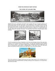
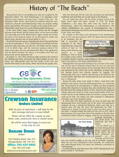
The remains of The Nancy were discovered in the Nottawasaga<br />
River in 1911 and were raised in 1928. The Nancy had been burned<br />
to its waterline, but the<br />
hull is preserved and<br />
displayed at the Nancy<br />
Island Museum, along with<br />
artifacts of that era. The<br />
Nancy Island Museum was<br />
opened as a single<br />
building in 1928 to house<br />
the remains. It has evolved<br />
Nancy Island Museum<br />
and Swing Bridge circa 1940<br />
to include a theatre, museum, replica lighthouse and outdoor artifacts<br />
and is now known as The Nancy Island Historic Site.<br />
Although there was not much farming in our area due to the sandy<br />
soil, the first sign of settlement began when the area was surveyed<br />
in the 1820’s and became known as Flos Township. Most of the land<br />
was surveyed by the 1830’s. Due to the abundance of large trees,<br />
the <strong>Wasaga</strong> <strong>Beach</strong> area became popular for logging. The<br />
Nottawasaga River was a natural route for logs to be floated to the<br />
several lumber mills that were located both up river and across the<br />
bay in Collingwood.<br />
During this time, plans were made to build a canal from Lake<br />
Ontario to Lake Huron, using the Nottawasaga River as a connecting<br />
link. This proved to be too expensive. A railway was then proposed<br />
joining York (Toronto) to Georgian Bay, and construction began on<br />
the first leg of the railway to Barrie in 1851. Based on the proposed<br />
railway, plans were made to create a town named Hythe at the river<br />
mouth, but due to the shifting sandy river bottom, a proper harbour<br />
could not be built. The railway was then extended to Collingwood<br />
and Hythe was never formally created.<br />
In 1870, John Van Vlack purchased 69 acres of land near the<br />
Nottawasaga River and became one of the area’s first permanent<br />
residents. He was a commercial fisherman, built a saw mill, ran a<br />
general store and was the area’s first postmaster. By 1896, a<br />
settlement of around 70 people lived in what was then known as<br />
Van Vlack. A wooden bridge was built over the river in 1872, with a<br />
hotel opening a few years later. Most of the families in the Van Vlack<br />
settlement either fished or logged, with the surrounding area<br />
gradually developing a<br />
Van Vlack Bridge<br />
few small farms. The<br />
settlement also had a<br />
school.<br />
The first official use of<br />
the name <strong>Wasaga</strong> <strong>Beach</strong><br />
appears around the end<br />
of the 1880’s. The Van<br />
Vlack settlement was<br />
situated in Flos<br />
Township, and the beach<br />
area was located roughly at the top end of Sunnidale Township.<br />
When the lots were subdivided in that Township, one subdivision<br />
was called <strong>Wasaga</strong> <strong>Beach</strong>. The name was obviously a derivative of<br />
“Nottawasaga”.<br />
It is interesting to note that even in the 1890’s, <strong>Wasaga</strong> <strong>Beach</strong> was<br />
known locally as “The <strong>Beach</strong>”.<br />
16 www.wasagainfo.com